T. Schenk IGERT Colloqium 2/22/08 2
|
|
|
- Walter Knight
- 5 years ago
- Views:
Transcription
1 Populating/Updating GIS: Automatically? ti Toni Schenk Department of Civil and Environmental Engineering and Geodetic Science The Ohio State University T. Schenk IGERT Colloqium 2/22/08 1
2 Motivation Usefulness of GIS depends greatly on its information content. Information should be rich (satisfy current and future needs) accurate up-to to-date Keeping information up-to to-date may be biggest challenge how to detect changes how to update changes T. Schenk IGERT Colloqium 2/22/08 2
3 Motivation Populating and updating GIS manually is slow expensive Ever increasing amount of data poses challenge to extract t GIS information Can the processes of creating and updating GIS be automated? Your new GIS update is ready to be installed. Do you want to install it now? T. Schenk IGERT Colloqium 2/22/08 3
4 GIS Players surveying GIS photogrammetry t -populate remote sensing -update user data information knowledge Geospatial Information providers Geospatial Information managers T. Schenk IGERT Colloqium 2/22/08 4
5 Data sensor output, result of data acquisition raw signals or preprocessed data t is not an end product, nor does it directly provide answers to applications examples: pixels, laser points data needs to be (further) processed T. Schenk IGERT Colloqium 2/22/08 5
6 Information more specific than data to answer questions information can be retrieved from data information implicitly in data extracting information from data makes it explicit it feature extraction ti features are information primitives T. Schenk IGERT Colloqium 2/22/08 6
7 Knowledge elusive concept, ill-defined means different things to different people to deal withknowledgeitmustbe represented knowledge and its representation are closely related knowledge: facts, procedures, heuristics that t can be used to make inferences T. Schenk IGERT Colloqium 2/22/08 7
8 Data, Information, Knowledge semantic content data information knowledge signal representation symbolic T. Schenk IGERT Colloqium 2/22/08 8
9 Data, Information and GIS GIS contains explicit geospatial information about objects, e.g. a polygon is labeled with building, the vertices may be considered data The object is extracted from raw data, e.g. images Volume l of raw data >> volume of GIS information T. Schenk IGERT Colloqium 2/22/08 9
10 Example GIS of a rural county: 10,000 centerline segments 80,000 parcels 13,000 sewer line segments 130,000 spot elevation points 12,000 water line segments Input data: aerial images GSD 0.1 m County 25 x 25 miles e+12 pixels 3 x 2.5 x e+12 MB 180 MB 1.2 TB T. Schenk IGERT Colloqium 2/22/08 10


11 Data Deluge data information? T. Schenk IGERT Colloqium 2/22/08 11


12 From Data to Information and Knowledge in Human Vision i knowledge perception scene information data acquisition data T. Schenk IGERT Colloqium 2/22/08 12


13 Image Formation on Retina ~1 Mio ganglion cells raw information ~120 Mio photoreceptors raw data T. Schenk IGERT Colloqium 2/22/08 13
14 Paradigm data acquisition preprocessing raw data data feature extraction perceptual organization applications infor rmation kn nowledge T. Schenk IGERT Colloqium 2/22/08 14


15 Representational Issue image seen by computer image seen by human T. Schenk IGERT Colloqium 2/22/08 15


16 Spatial Extent: The Peephole 3x3 3 T. Schenk IGERT Colloqium 2/22/08 16
17 Connect-the the-dots Metaphor connect-the-dots algorithm Meaning of structure? C I I L N O T. Schenk IGERT Colloqium 2/22/08 17
18 Intelligent Data Acquisition add one new point: where should it be added to yield maximum information information gain ? T. Schenk IGERT Colloqium 2/22/08 18


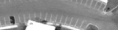
19 Example Image Ocean City, x 1320 pixels pixelsize ~ 15 micron T. Schenk IGERT Colloqium 2/22/08 19


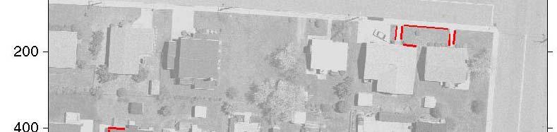
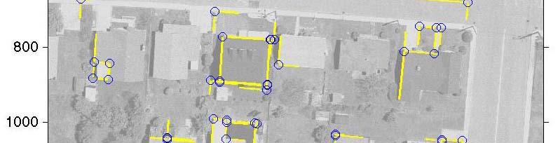
20 Examples of Edge Images Canny edge detector T. Schenk IGERT Colloqium 2/22/08 20


21 Examples of Edge Images T. Schenk IGERT Colloqium 2/22/08 21


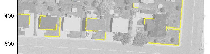
22 Segmented Edges straight line segments length > 25 pixels T. Schenk IGERT Colloqium 2/22/08 22


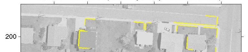
23 Connecting Edge Segments connects edge segments with same line properties and small gap T. Schenk IGERT Colloqium 2/22/08 23


24 Connecting Edge Segments connects edges with larger gaps T. Schenk IGERT Colloqium 2/22/08 24


25 Parallel Edges distance between parallel l lines < 10 pixels T. Schenk IGERT Colloqium 2/22/08 25


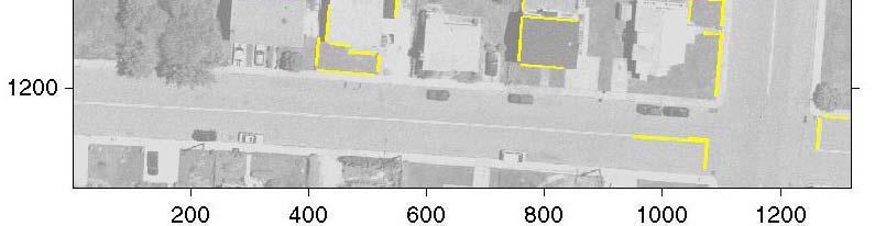
26 Parallel Edges distance between parallel edges < 200 pixels T. Schenk IGERT Colloqium 2/22/08 26


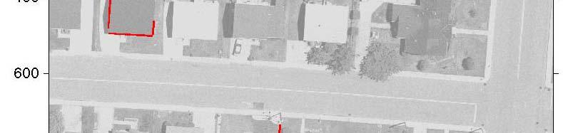
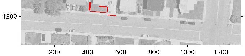
27 Perpendicular Edges edges are grouped to perpendicular pairs, considering proximity T. Schenk IGERT Colloqium 2/22/08 27


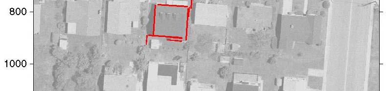
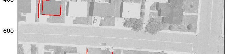
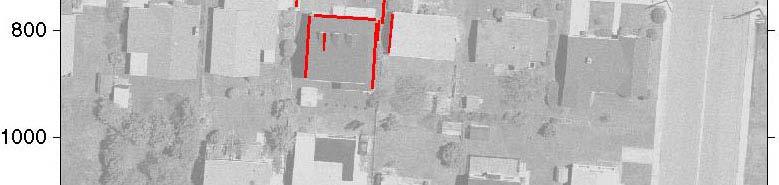
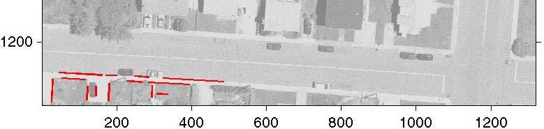
28 Computed Corner Points corners are computed from perpendicular p edges T. Schenk IGERT Colloqium 2/22/08 28
29 Clustering Perpendicular Edges T. Schenk all perpendicular edges IGERT Colloqium 2/22/08 example of 4 clusters 29

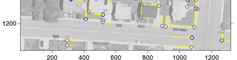
30 Clustering Perpendicular Edges T. Schenk all perpendicular edges IGERT Colloqium 2/22/08 example of 3 clusters 30


31 From Data to Information and Knowledge in a GIS Environment data information query knowledg ge T. Schenk IGERT Colloqium 2/22/08 31
32 Information and Knowledge Generating Processes T. Schenk IGERT Colloqium 2/22/08 32
33 A World of Models graphics world visualiz zation GIS add. information reconstructed t world our world model world hypothesized world humans sensors physical world T. Schenk IGERT Colloqium 2/22/08 33
34 Concluding Remarks data < information < knowledge bottleneck in generating and updating GIS lies in information extraction from data and NOT in data collection end d products consist of information + knowledge from data to information by extracting features and their perceptual organization T. Schenk IGERT Colloqium 2/22/08 34
35 Concluding Remarks Over lifetime of GIS: cost of updating >> original creation Automate update Aspects of updating Detect changes Implement changes T. Schenk IGERT Colloqium 2/22/08 35
36 Concluding Remarks Additional updating considerations Update attributes of objects Precision Upgrading from 2-D to 3-D Missing information thank you T. Schenk IGERT Colloqium 2/22/08 36
From Multi-sensor Data to 3D Reconstruction of Earth Surface: Innovative, Powerful Methods for Geoscience and Other Applications
 From Multi-sensor Data to 3D Reconstruction of Earth Surface: Innovative, Powerful Methods for Geoscience and Other Applications Bea Csatho, Toni Schenk*, Taehun Yoon* and Michael Sheridan, Department
IMAGINE Objective. The Future of Feature Extraction, Update & Change Mapping
 IMAGINE ive The Future of Feature Extraction, Update & Change Mapping IMAGINE ive provides object based multi-scale image classification and feature extraction capabilities to reliably build and maintain
BUILDING MODEL RECONSTRUCTION FROM DATA INTEGRATION INTRODUCTION
 BUILDING MODEL RECONSTRUCTION FROM DATA INTEGRATION Ruijin Ma Department Of Civil Engineering Technology SUNY-Alfred Alfred, NY 14802 mar@alfredstate.edu ABSTRACT Building model reconstruction has been
AUTOMATIC EXTRACTION OF BUILDING ROOFS FROM PICTOMETRY S ORTHOGONAL AND OBLIQUE IMAGES
 AUTOMATIC EXTRACTION OF BUILDING ROOFS FROM PICTOMETRY S ORTHOGONAL AND OBLIQUE IMAGES Yandong Wang Pictometry International Corp. Suite A, 100 Town Centre Dr., Rochester, NY14623, the United States yandong.wang@pictometry.com
FUSION OF LIDAR DATA AND AERIAL IMAGERY FOR A MORE COMPLETE SURFACE DESCRIPTION
 FUSION OF LIDAR DATA AND AERIAL IMAGERY FOR A MORE COMPLETE SURFACE DESCRIPTION Toni Schenk CEEGS Department The Ohio State University schenk.2@osu.edu Commission III, Working Group 5 Bea Csathó Byrd Polar
Spatial Data Management
 Spatial Data Management [R&G] Chapter 28 CS432 1 Types of Spatial Data Point Data Points in a multidimensional space E.g., Raster data such as satellite imagery, where each pixel stores a measured value
Lecture 6: GIS Spatial Analysis. GE 118: INTRODUCTION TO GIS Engr. Meriam M. Santillan Caraga State University
 Lecture 6: GIS Spatial Analysis GE 118: INTRODUCTION TO GIS Engr. Meriam M. Santillan Caraga State University 1 Spatial Data It can be most simply defined as information that describes the distribution
Spatial Data Management
 Spatial Data Management Chapter 28 Database management Systems, 3ed, R. Ramakrishnan and J. Gehrke 1 Types of Spatial Data Point Data Points in a multidimensional space E.g., Raster data such as satellite
A DATA DRIVEN METHOD FOR FLAT ROOF BUILDING RECONSTRUCTION FROM LiDAR POINT CLOUDS
 A DATA DRIVEN METHOD FOR FLAT ROOF BUILDING RECONSTRUCTION FROM LiDAR POINT CLOUDS A. Mahphood, H. Arefi *, School of Surveying and Geospatial Engineering, College of Engineering, University of Tehran,
A Method to Create a Single Photon LiDAR based Hydro-flattened DEM
 A Method to Create a Single Photon LiDAR based Hydro-flattened DEM Sagar Deshpande 1 and Alper Yilmaz 2 1 Surveying Engineering, Ferris State University 2 Department of Civil, Environmental, and Geodetic
Prof. Jose L. Flores, MS, PS Dept. of Civil Engineering & Surveying
 Prof. Jose L. Flores, MS, PS Dept. of Civil Engineering & Surveying Problem One of the challenges for any Geographic Information System (GIS) application is to keep the spatial data up to date and accurate.
automatic digitization. In the context of ever increasing population worldwide and thereby
 Chapter 1 Introduction In the recent time, many researchers had thrust upon developing various improvised methods of automatic digitization. In the context of ever increasing population worldwide and thereby
GIS Data Collection. This chapter reviews the main methods of GIS data capture and transfer and introduces key practical management issues.
 9 GIS Data Collection OVERVIEW This chapter reviews the main methods of GIS data capture and transfer and introduces key practical management issues. It distinguishes between primary (direct measurement)
Section G. POSITIONAL ACCURACY DEFINITIONS AND PROCEDURES Approved 3/12/02
 Section G POSITIONAL ACCURACY DEFINITIONS AND PROCEDURES Approved 3/12/02 1. INTRODUCTION Modern surveying standards use the concept of positional accuracy instead of error of closure. Although the concepts
Digital Softcopy Photogrammetry
 LLP Erasmus IP EPOCHE 2013 Thassos Island, Greece, 2-16 June 2013 Digital Softcopy Photogrammetry Prof. Levente DIMEN The 1 Decembrie 1918 University of Alba Iulia, Romania GENERAL CONTEXT In the last
ACCURACY STUDY OF AIRBORNE LASER SCANNING DATA WITH PHOTOGRAMMETRY
 ACCURACY STUDY OF AIRBORNE LASER SCANNING DATA WITH PHOTOGRAMMETRY Toni Schenk 1, Suyoung Seo 1,Beáta Csathó 2 1 Department of Civil and Environmental Engineering and Geodetic Science 2 Byrd Polar Research
EDGE EXTRACTION ALGORITHM BASED ON LINEAR PERCEPTION ENHANCEMENT
 EDGE EXTRACTION ALGORITHM BASED ON LINEAR PERCEPTION ENHANCEMENT Fan ZHANG*, Xianfeng HUANG, Xiaoguang CHENG, Deren LI State Key Laboratory of Information Engineering in Surveying, Mapping and Remote Sensing,
BUILDING ROOF RECONSTRUCTION BY FUSING LASER RANGE DATA AND AERIAL IMAGES
 BUILDING ROOF RECONSTRUCTION BY FUSING LASER RANGE DATA AND AERIAL IMAGES J.J. Jaw *,C.C. Cheng Department of Civil Engineering, National Taiwan University, 1, Roosevelt Rd., Sec. 4, Taipei 10617, Taiwan,
Principles of Data Management. Lecture #14 (Spatial Data Management)
") Principles of Data Management Lecture #14 (Spatial Data Management) Instructor: Mike Carey mjcarey@ics.uci.edu Database Management Systems 3ed, R. Ramakrishnan and J. Gehrke 1 Today s Notable News v Project
Principles of Data Management Lecture #14 (Spatial Data Management) Instructor: Mike Carey mjcarey@ics.uci.edu Database Management Systems 3ed, R. Ramakrishnan and J. Gehrke 1 Today s Notable News v Project
AUTOMATIC EXTRACTION OF BUILDING FEATURES FROM TERRESTRIAL LASER SCANNING
 AUTOMATIC EXTRACTION OF BUILDING FEATURES FROM TERRESTRIAL LASER SCANNING Shi Pu and George Vosselman International Institute for Geo-information Science and Earth Observation (ITC) spu@itc.nl, vosselman@itc.nl
AUTOMATIC EXTRACTION OF LARGE COMPLEX BUILDINGS USING LIDAR DATA AND DIGITAL MAPS
 AUTOMATIC EXTRACTION OF LARGE COMPLEX BUILDINGS USING LIDAR DATA AND DIGITAL MAPS Jihye Park a, Impyeong Lee a, *, Yunsoo Choi a, Young Jin Lee b a Dept. of Geoinformatics, The University of Seoul, 90
Review of Cartographic Data Types and Data Models
 Review of Cartographic Data Types and Data Models GIS Data Models Raster Versus Vector in GIS Analysis Fundamental element used to represent spatial features: Raster: pixel or grid cell. Vector: x,y coordinate
Data, Data, Everywhere. We are now in the Big Data Era.
 Data, Data, Everywhere. We are now in the Big Data Era. CONTENTS Background Big Data What is Generating our Big Data Physical Management of Big Data Optimisation in Data Processing Techniques for Handling
Multidimensional Indexing The R Tree
 Multidimensional Indexing The R Tree Module 7, Lecture 1 Database Management Systems, R. Ramakrishnan 1 Single-Dimensional Indexes B+ trees are fundamentally single-dimensional indexes. When we create
Spectral Interpretation Based on Multisensor Fusion for Urban Mapping
 Spectral Interpretation Based on Multisensor Fusion for Urban Mapping Beáta Csathó Byrd Polar Research Center The Ohio State University 1090 Carmack Rd., Columbus, OH 43210 Email: csatho.1@osu.edu Toni
The raycloud A Vision Beyond the Point Cloud
 The raycloud A Vision Beyond the Point Cloud Christoph STRECHA, Switzerland Key words: Photogrammetry, Aerial triangulation, Multi-view stereo, 3D vectorisation, Bundle Block Adjustment SUMMARY Measuring
GENERATING BUILDING OUTLINES FROM TERRESTRIAL LASER SCANNING
 GENERATING BUILDING OUTLINES FROM TERRESTRIAL LASER SCANNING Shi Pu International Institute for Geo-information Science and Earth Observation (ITC), Hengelosestraat 99, P.O. Box 6, 7500 AA Enschede, The
Western Land Area Programmatic Environmental Assessment. APPENDIX F: Viewshed Study
 APPENDIX F: Viewshed Study Dulles International Airport Western Land Area Viewshed Study FINAL Prepared by: EAC/Archaeology, Inc. September 26, 2017 Western Land Area This page is left intentionally blank.
Development of Geospatial Smart Cities and Management
 Presented at the FIG Congress 2018, May 6-11, 2018 in Istanbul, Turkey Development of Geospatial Smart Cities and Management (E. Yılmaz, F. Kartal, E. Uçar, K. Eren) FIG2018 - Istanbul, 8 th May 2018 1
City of La Crosse Online Mapping Website Help Document
 City of La Crosse Online Mapping Website Help Document This document was created to assist in using the new City of La Crosse online mapping sites. When the website is first opened, a map showing the City
A DBMS-BASED 3D TOPOLOGY MODEL FOR LASER RADAR SIMULATION
 A DBMS-BASED 3D TOPOLOGY MODEL FOR LASER RADAR SIMULATION C. Jun a, * G. Kim a a Dept. of Geoinformatics, University of Seoul, Seoul, Korea - (cmjun, nani0809)@uos.ac.kr Commission VII KEY WORDS: Modelling,
Sedimentation in Aquilla Lake Hill County, Texas
 Sedimentation in Aquilla Lake Hill County, Texas by Lorena Roque Martinez, GIS and GPS Applications in Earth Sciences (GEO 327G) Introduction The Texas Water Development Board (TWDB) is in charge of offering
PUBLIC WORKS. 1oo. DiEital Fee Schedules. Effective January 1, 2008
 PUBLIC WORKS Geographic Information Systems DiEital Fee Schedules Effective January 1, 2008 Date Advertised 12103/07 In (Publication) Daily Business Journal Public Hearing Date Approved as to form: David
GE1LC7 - Getting to Know Bentley Descartes for Advanced Image Viewing, Editing and Processing
 GE1LC7 - Getting to Know Bentley Descartes for Advanced Image Viewing, Editing and Processing Inga Morozoff Introduction: Raster data is everywhere - whether you do CAD design, mapping or GIS analysis,
Understanding Geospatial Data Models
 Understanding Geospatial Data Models 1 A geospatial data model is a formal means of representing spatially referenced information. It is a simplified view of physical entities and a conceptualization of
Oracle Big Data Spatial and Graph: Spatial Features
 Oracle Big Data Spatial and Graph: Spatial Features January 28 th, 2016 Siva Ravada Senior Director of Development Copyright 2015, Oracle and/or its affiliates. All rights reserved. Program Agenda 1 2
CO-REGISTERING AND NORMALIZING STEREO-BASED ELEVATION DATA TO SUPPORT BUILDING DETECTION IN VHR IMAGES
 CO-REGISTERING AND NORMALIZING STEREO-BASED ELEVATION DATA TO SUPPORT BUILDING DETECTION IN VHR IMAGES Alaeldin Suliman, Yun Zhang, Raid Al-Tahir Department of Geodesy and Geomatics Engineering, University
Trimble VISION Positions from Pictures
 Trimble VISION Positions from Pictures This session will cover What Is Trimble VISION? Trimble VISION Portfolio What Do you Need? How Does It Work & How Accurate Is It? Applications Resources Trimble VISION
ENY-C2005 Geoinformation in Environmental Modeling Lecture 4b: Laser scanning
 1 ENY-C2005 Geoinformation in Environmental Modeling Lecture 4b: Laser scanning Petri Rönnholm Aalto University 2 Learning objectives To recognize applications of laser scanning To understand principles
DATA FUSION FOR MULTI-SCALE COLOUR 3D SATELLITE IMAGE GENERATION AND GLOBAL 3D VISUALIZATION
 DATA FUSION FOR MULTI-SCALE COLOUR 3D SATELLITE IMAGE GENERATION AND GLOBAL 3D VISUALIZATION ABSTRACT: Yun Zhang, Pingping Xie, and Hui Li Department of Geodesy and Geomatics Engineering, University of
AUTOMATIC GENERATION OF DIGITAL BUILDING MODELS FOR COMPLEX STRUCTURES FROM LIDAR DATA
 AUTOMATIC GENERATION OF DIGITAL BUILDING MODELS FOR COMPLEX STRUCTURES FROM LIDAR DATA Changjae Kim a, Ayman Habib a, *, Yu-Chuan Chang a a Geomatics Engineering, University of Calgary, Canada - habib@geomatics.ucalgary.ca,
Designing and Using Basemaps. Jennifer Hughey
 Designing and Using Basemaps Jennifer Hughey Agenda The ArcGIS System Basemaps are a key component of your system Cartographic design considerations Using basemap layers in ArcMap Best practices for designing
A Hierarchial Model for Visual Perception
 A Hierarchial Model for Visual Perception Bolei Zhou 1 and Liqing Zhang 2 1 MOE-Microsoft Laboratory for Intelligent Computing and Intelligent Systems, and Department of Biomedical Engineering, Shanghai
Purpose: To explore the raster grid and vector map element concepts in GIS.
 GIS INTRODUCTION TO RASTER GRIDS AND VECTOR MAP ELEMENTS c:wou:nssi:vecrasex.wpd Purpose: To explore the raster grid and vector map element concepts in GIS. PART A. RASTER GRID NETWORKS Task A- Examine
Managing Imagery and Raster Data using Mosaic Datasets
 Esri European User Conference October 15-17, 2012 Oslo, Norway Hosted by Esri Official Distributor Managing Imagery and Raster Data using Mosaic Datasets Peter Becker ArcGIS is a Comprehensive Imagery
HEURISTIC FILTERING AND 3D FEATURE EXTRACTION FROM LIDAR DATA
 HEURISTIC FILTERING AND 3D FEATURE EXTRACTION FROM LIDAR DATA Abdullatif Alharthy, James Bethel School of Civil Engineering, Purdue University, 1284 Civil Engineering Building, West Lafayette, IN 47907
BUILDING BOUNDARY EXTRACTION FROM HIGH RESOLUTION IMAGERY AND LIDAR DATA
 BUILDING BOUNDARY EXTRACTION FROM HIGH RESOLUTION IMAGERY AND LIDAR DATA Liang Cheng, Jianya Gong, Xiaoling Chen, Peng Han State Key Laboratory of Information Engineering in Surveying, Mapping and Remote
Hamilton County Enhances GIS Base Mapping with 1-foot Contours
 Hamilton County Enhances GIS Base Mapping with 1-foot Contours Presented by Larry Stout, Hamilton County GIS Manager Brad Fugate, Woolpert Inc. Today s Presentation Hamilton County s 2004 Base Mapping
Assimilation of Break line and LiDAR Data within ESRI s Terrain Data Structure (TDS) for creating a Multi-Resolution Terrain Model
 for creating a Multi-Resolution Terrain Model") Assimilation of Break line and LiDAR Data within ESRI s Terrain Data Structure (TDS) for creating a Multi-Resolution Terrain Model Tarig A. Ali Department of Civil Engineering American University of Sharjah,
Assimilation of Break line and LiDAR Data within ESRI s Terrain Data Structure (TDS) for creating a Multi-Resolution Terrain Model Tarig A. Ali Department of Civil Engineering American University of Sharjah,
Machine Vision based Data Acquisition, Processing & Automation for Subsea Inspection & Detection
 Machine Vision based Data Acquisition, Processing & Automation for Subsea Inspection & Detection 1 st Nov 2017 SUT Presentation: The Leading Edge of Value Based Subsea Inspection Adrian Boyle CEO Introduction
International Archives of Photogrammetry and Remote Sensing, Vol. 32, Part W6, Valladolid, Spain, 3-4 June, 1999
 INCLUSION OF MULTISPECTRAL DATA INTO OBJECT RECOGNITION Bea Csathó 1, Toni Schenk, Dong-Cheon Lee and Sagi Filin 2 1 Byrd Polar Research Center, OSU, 1090 Carmack Rd., Columbus, OH 43210, email: csatho.1@osu.edu,
DATA FUSION AND INTEGRATION FOR MULTI-RESOLUTION ONLINE 3D ENVIRONMENTAL MONITORING
 DATA FUSION AND INTEGRATION FOR MULTI-RESOLUTION ONLINE 3D ENVIRONMENTAL MONITORING Yun Zhang, Pingping Xie, Hui Li Department of Geodesy and Geomatics Engineering, University of New Brunswick Fredericton,
Volumetric Calculations. Sample Data
 Volumetric Calculations Sample Data Stockpiles of industrial materials are often difficult to measure accurately. LiDAR offers a fast and extremely accurate solution for taking periodical inventory of
UAV-based Mapping of Surface Imperviousness for Water Runoff Modelling
 UAV-based Mapping of Surface Imperviousness for Water Runoff Modelling Piotr Tokarczyk, Jörg Rieckermann, Frank Blumensaat, Joao Paulo Leitao and Konrad Schindler Institute for Geodesy and Photogrammetry
The City of Huntsville, Texas GIS Mapping System
 The City of Huntsville, Texas GIS Mapping System Author: Huntsville, Texas GIS Division GIS DATA & MAP DISCLAIMER: The City of Huntsville, Texas shall not be held liable for improper or incorrect use of
Canny Edge Based Self-localization of a RoboCup Middle-sized League Robot
 Canny Edge Based Self-localization of a RoboCup Middle-sized League Robot Yoichi Nakaguro Sirindhorn International Institute of Technology, Thammasat University P.O. Box 22, Thammasat-Rangsit Post Office,
3DPIXA: options and challenges with wirebond inspection. Whitepaper
 3DPIXA: options and challenges with wirebond inspection Whitepaper Version Author(s) Date R01 Timo Eckhard, Maximilian Klammer 06.09.2017 R02 Timo Eckhard 18.10.2017 Executive Summary: Wirebond inspection
NATIONWIDE POINT CLOUDS AND 3D GEO- INFORMATION: CREATION AND MAINTENANCE GEORGE VOSSELMAN
 NATIONWIDE POINT CLOUDS AND 3D GEO- INFORMATION: CREATION AND MAINTENANCE GEORGE VOSSELMAN OVERVIEW National point clouds Airborne laser scanning in the Netherlands Quality control Developments in lidar
EVALUATION OF WORLDVIEW-1 STEREO SCENES AND RELATED 3D PRODUCTS
 EVALUATION OF WORLDVIEW-1 STEREO SCENES AND RELATED 3D PRODUCTS Daniela POLI, Kirsten WOLFF, Armin GRUEN Swiss Federal Institute of Technology Institute of Geodesy and Photogrammetry Wolfgang-Pauli-Strasse
GEOGRAPHIC INFORMATION SYSTEMS Lecture 02: Feature Types and Data Models
 GEOGRAPHIC INFORMATION SYSTEMS Lecture 02: Feature Types and Data Models Feature Types and Data Models How Does a GIS Work? - a GIS operates on the premise that all of the features in the real world can
Automatic urbanity cluster detection in street vector databases with a raster-based algorithm
 Automatic urbanity cluster detection in street vector databases with a raster-based algorithm Volker Walter, Steffen Volz University of Stuttgart Institute for Photogrammetry Geschwister-Scholl-Str. 24D
GEOGRAPHIC INFORMATION SYSTEMS Lecture 18: Spatial Modeling
 Spatial Analysis in GIS (cont d) GEOGRAPHIC INFORMATION SYSTEMS Lecture 18: Spatial Modeling - the basic types of analysis that can be accomplished with a GIS are outlined in The Esri Guide to GIS Analysis
May 2013 Oracle Spatial and Graph User Conference
 May 2013 Oracle Spatial and Graph User Conference May 22, 2013 Ronald Reagan Building and International Trade Center Washington, DC USA Paul Calhoun & Vince Smith GIS Systems Analyst City Of Virginia Beach
IGTF 2016 Fort Worth, TX, April 11-15, 2016 Submission 149
 IGTF 26 Fort Worth, TX, April -5, 26 2 3 4 5 6 7 8 9 2 3 4 5 6 7 8 9 2 2 Light weighted and Portable LiDAR, VLP-6 Registration Yushin Ahn (yahn@mtu.edu), Kyung In Huh (khuh@cpp.edu), Sudhagar Nagarajan
Data Representation in Visualisation
 Data Representation in Visualisation Visualisation Lecture 4 Taku Komura Institute for Perception, Action & Behaviour School of Informatics Taku Komura Data Representation 1 Data Representation We have
DATA MODELS IN GIS. Prachi Misra Sahoo I.A.S.R.I., New Delhi
 DATA MODELS IN GIS Prachi Misra Sahoo I.A.S.R.I., New Delhi -110012 1. Introduction GIS depicts the real world through models involving geometry, attributes, relations, and data quality. Here the realization
Surface Contents Author Index
 Surface Contents Author Index Xiangyun HU & C.Vincent Tao AUTOMATIC MAIN ROAD EXTRACTION FROM HIGH RESOLUTION SATELLITE IMAGERY Xiangyun HU, C.Vincent Tao Geospatial Information and Communication (Geo-ICT)
Use of Satellite Imagery for Establishing Road Horizontal Alignments
 Use of Satellite Imagery for Establishing Road Horizontal Alignments Said M. Easa, M.ASCE 1 ; Haibin Dong 2 ; and Jonathan Li 3 Downloaded from ascelibrary.org by University of Waterloo on 10/05/17. Copyright
A NEW APPROACH FOR GENERATING A MEASURABLE SEAMLESS STEREO MODEL BASED ON MOSAIC ORTHOIMAGE AND STEREOMATE
 A NEW APPROACH FOR GENERATING A MEASURABLE SEAMLESS STEREO MODEL BASED ON MOSAIC ORTHOIMAGE AND STEREOMATE Mi Wang State Key Laboratory of Information Engineering in Surveying Mapping and Remote Sensing
Algorithms for GIS: Terrain simplification
 Algorithms for GIS: Terrain simplification Digital terrain models in GIS grid (raster) TIN Data Sources: digitizing contour maps Data Sources: satellite imagery Data Sources: satellite imagery \ Data Sources:
Geometric Rectification Using Feature Points Supplied by Straight-lines
 Available online at www.sciencedirect.com Procedia Environmental Sciences (0 ) 00 07 Geometric Rectification Using Feature Points Supplied by Straight-lines Tengfei Long, Weili Jiao, Wei Wang Center for
Thomas Labe. University ofbonn. A program for the automatic exterior orientation called AMOR was developed by Wolfgang
 Contributions to the OEEPE-Test on Automatic Orientation of Aerial Images, Task A - Experiences with AMOR Thomas Labe Institute of Photogrammetry University ofbonn laebe@ipb.uni-bonn.de (in: OEEPE Publication
Matthew Heric, Geoscientist and Kevin D. Potter, Product Manager. Autometric, Incorporated 5301 Shawnee Road Alexandria, Virginia USA
 INTEGRATIONS OF STRUCTURED QUERY LANGUAGE WITH GEOGRAPHIC INFORMATION SYSTEM PROCESSING: GeoServer Matthew Heric, Geoscientist and Kevin D. Potter, Product Manager Autometric, Incorporated 5301 Shawnee
AERIAL IMAGE MATCHING BASED ON ZERO-CROSSINGS
 AERIAL IMAGE MATCHING BASED ON ZERO-CROSSINGS Jia Zong Jin-Cheng Li Toni Schenk Department of Geodetic Science and Surveying The Ohio State University, Columbus, Ohio 43210-1247 USA Commission III ABSTRACT
Exploration of Unknown or Partially Known. Prof. Dr. -Ing. G. Farber. the current step. It can be derived from a third camera
 Exploration of Unknown or Partially Known Environments? Darius Burschka, Christof Eberst Institute of Process Control Computers Prof. Dr. -Ing. G. Farber Technische Universitat Munchen 80280 Munich, Germany
Summary of Research and Development Efforts Necessary for Assuring Geometric Quality of Lidar Data
 American Society for Photogrammetry and Remote Sensing (ASPRS) Summary of Research and Development Efforts Necessary for Assuring Geometric Quality of Lidar Data 1 Summary of Research and Development Efforts
SINGLE IMAGE ORIENTATION USING LINEAR FEATURES AUTOMATICALLY EXTRACTED FROM DIGITAL IMAGES
 SINGLE IMAGE ORIENTATION USING LINEAR FEATURES AUTOMATICALLY EXTRACTED FROM DIGITAL IMAGES Nadine Meierhold a, Armin Schmich b a Technical University of Dresden, Institute of Photogrammetry and Remote
Technology for Cadastral Applications. John R. Hacker, Jr. Marketing Manager Geospatial Applications
 Technology for Cadastral Applications John R. Hacker, Jr. Marketing Manager Geospatial Applications Agenda Cadastral Mapping Issues Precision and Accuracy Data Creation Data Management Data Publishing
CHAPTER 6 PERCEPTUAL ORGANIZATION BASED ON TEMPORAL DYNAMICS
 CHAPTER 6 PERCEPTUAL ORGANIZATION BASED ON TEMPORAL DYNAMICS This chapter presents a computational model for perceptual organization. A figure-ground segregation network is proposed based on a novel boundary
City of Fontana. GIS: Making Life Easier Presenters: Joe Field, Rogelio Matta
 City of Fontana GIS: Making Life Easier Presenters: Joe Field, Rogelio Matta Fontana Fontana44.5 Square Miles Population 209,000 60 miles east of Los Angeles Fontana Public Works Department 94 Staff $52
Trimble Geospatial Division Integrated Solutions for Geomatics professions. Volker Zirn Regional Sales Representative
 Trimble Geospatial Division Integrated Solutions for Geomatics professions Volker Zirn Regional Sales Representative 1 Agenda Trimble GeoSpatial Division Airborne System Solutions Trimble Inpho Software
ACCURACY ANALYSIS FOR NEW CLOSE-RANGE PHOTOGRAMMETRIC SYSTEMS
 ACCURACY ANALYSIS FOR NEW CLOSE-RANGE PHOTOGRAMMETRIC SYSTEMS Dr. Mahmoud El-Nokrashy O. ALI Prof. of Photogrammetry, Civil Eng. Al Azhar University, Cairo, Egypt m_ali@starnet.com.eg Dr. Mohamed Ashraf
EAT 233/3 GEOGRAPHIC INFORMATION SYSTEM (GIS)
") EAT 233/3 GEOGRAPHIC INFORMATION SYSTEM (GIS) CO3: Ability to produce detail mapping using geographic information systems (GIS) BY : AYU WAZIRA AZHARI SPATIAL DATA & THE MODELLING Spatial Data in GIS Spatial
EAT 233/3 GEOGRAPHIC INFORMATION SYSTEM (GIS) CO3: Ability to produce detail mapping using geographic information systems (GIS) BY : AYU WAZIRA AZHARI SPATIAL DATA & THE MODELLING Spatial Data in GIS Spatial
LSGI 521: Principles of GIS. Lecture 5: Spatial Data Management in GIS. Dr. Bo Wu
 Lecture 5: Spatial Data Management in GIS Dr. Bo Wu lsbowu@polyu.edu.hk Department of Land Surveying & Geo-Informatics The Hong Kong Polytechnic University Contents 1. Learning outcomes 2. From files to
METRIC AND QUALITATIVE EVALUATION OF QUICKBIRD ORTHOIMAGES FOR A LARGE SCALE GEODATABASE CREATION
 METRIC AND QUALITATIVE EVALUATION OF QUICKBIRD ORTHOIMAGES FOR A LARGE SCALE GEODATABASE CREATION Maurizio Barbarella, Michela Zanni DISTART Università di Bologna maurizio.barbarella@mail.ing.unibo.it,
CONCOCTING A GIS. Designing a Geodatabase Optimized for Data Maintenance and Map Production
 CONCOCTING A GIS Designing a Geodatabase Optimized for Data Maintenance and Map Production Jim Isbell Engineering Tech. II Kern County Assessor s Office KERN COUNTY STATISTICS Size of Kern County 8,162
Introduction to GIS. Geographic Information Systems SOCR-377 9/24/2015. R. Khosla Fall Semester The real world. What in the world is GIS?
 Introduction to GIS Geographic Information Systems SOCR-377 What in the world is GIS? GIS is simultaneously the telescope, the microscope, the computer and the Xerox machine of regional analysis and synthesis
Building and Analyzing Topology in Autodesk Map GI21-1
 December 2-5, 2003 MGM Grand Hotel Las Vegas Building and Analyzing Topology in Autodesk Map GI21-1 Alex Penney ISD Training Content Manager, Autodesk Professional Services, Autodesk Inc. Topology is one
Construction, Smart Grid and Intelligent City Models. Geoff Zeiss Principal Between The Poles
 Construction, Smart Grid and Intelligent City Models Geoff Zeiss Principal Between The Poles Geospatial Media Technologies are evolving rapidly in the $7 trillion annually construction industry Evolution
Oracle Big Data Spatial and Graph: Spatial Features Roberto Infante 11/11/2015 Latin America Geospatial Forum
 Oracle Big Data Spatial and Graph: Spatial Features Roberto Infante 11/11/2015 Latin America Geospatial Forum Overview of Spatial features Vector Data Processing Support spatial processing of data stored
Mobile Mapping Solutions for Ohio s Integrated Transportation Network. Brian Foster, CP
 Mobile Mapping Solutions for Ohio s Integrated Transportation Network Brian Foster, CP About Woolpert Established in 1911 Over 600 Professionals 25 Offices $12,000,000 invested in new technology in last
AN INVESTIGATION INTO IMAGE ORIENTATION USING LINEAR FEATURES
 AN INVESTIGATION INTO IMAGE ORIENTATION USING LINEAR FEATURES P. G. Vipula Abeyratne a, *, Michael Hahn b a. Department of Surveying & Geodesy, Faculty of Geomatics, Sabaragamuwa University of Sri Lanka,
LECTURE 2 SPATIAL DATA MODELS
 LECTURE 2 SPATIAL DATA MODELS Computers and GIS cannot directly be applied to the real world: a data gathering step comes first. Digital computers operate in numbers and characters held internally as binary
Peoria County Front Desk Map Application
 Peoria County Front Desk Map Application Quick Guide, 2017 At a First Glance This guide will tell users all they need to know about the Peoria County Front Desk application which can be found on the Peoria
Trimble S6. General. The Trimble S6 Total Station provides the power and flexibility required by today\'s surveying professionals.
 Trimble S6 General Product Description Product Brochure The Trimble S6 Total Station provides the power and flexibility required by today\'s surveying professionals. /upload/165-868-5836.pdf Demonstration
REDI 5.0 User Manual
 REDI 5.0 User Manual OBJECTIVE: REDI (Regional Economic Development Information System) provides a quick, convenient and easy way of accessing the City of San Diego Business Incentive Zones (BIZ) information.
Bridging the gap between CAD and GIS for Cadastral Mapping
 Bridging the gap between CAD and GIS for Cadastral Mapping CCMA 2008 Annual Conference - Sacramento Colin Hobson Munsys, Inc Sample Customers North America Overview Munsys provides an integrated family
From Structure-from-Motion Point Clouds to Fast Location Recognition
 From Structure-from-Motion Point Clouds to Fast Location Recognition Arnold Irschara1;2, Christopher Zach2, Jan-Michael Frahm2, Horst Bischof1 1Graz University of Technology firschara, bischofg@icg.tugraz.at
US Geo-Explorer User s Guide. Web:
 US Geo-Explorer User s Guide Web: http://usgeoexplorer.org Updated on October 26, 2016 TABLE OF CONTENTS Introduction... 3 1. System Interface... 5 2. Administrative Unit... 7 2.1 Region Selection... 7
HIGH RESOLUTION DEMs AND ORTHO-IMAGE BASEMAPS FOR LOCAL GOVERNMENT APPLICATIONS
 HIGH RESOLUTION DEMs AND ORTHO-IMAGE BASEMAPS FOR LOCAL GOVERNMENT APPLICATIONS STATEMENT OF PROBLEM Digital Elevation Models (DEMs) are the digital representation of topographic and/or manmade features