Identification Of the Main 3D Scanning Techniques Suitable for Use in Cultural Heritage Objects
|
|
|
- Stanley Benson
- 5 years ago
- Views:
Transcription

1 Identification Of the Main 3D Scanning Techniques Suitable for Use in Cultural Heritage Objects Tobias Reich i3mainz, Institute for Spatial Information and Surveying Technology University of Applied Sciences Mainz, Germany
2 Agenda Basics Terrestrial Laserscanning Structure from Motion Application of the techniques in an excavation project The collapsed wood accumulation in the well-room of the Royal Palace of Qatna (Syria) High-Precision Measuring Techniques (3D acquisition of surfaces) Basics Different projects 1-16
3 Basics of Laserscanning Technology Measures distances and angles to object Generates 3D points similiar to a Total Station Difference: TLS creates homogeneous cloud with thousands of 3D points in short time Is established product for visualizing, reconstruction, deformation analysis, documentation and other applications The quality of TLS and its different influence factors are correlated i.e.: surface area, angle of incidence, recording distance 2-16
 http://www.faro.com gib.")


4 Basics of Laserscanning Technology (TLS) gib.uni-bonn.de Distance One sigma standard deviation 1 25 m 5 mm 50 m 9 mm Both information with a mean albedo and points (pts)/sec scan rate Point accuracy Leica GeoSystems HDS6000 out of the user s manual 3-16


; AgiSoft Photoscan (commercially) Workflow similar in")


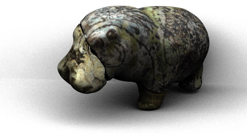
5 Basics of structure from motion Technology Technology originates in Robot Vision Technology tracking of objects, collision tests, motion control, etc. Used in different software packages to generate 3D point clouds / models from a group of pictures automatically examples: VisualSFM (Open Source); AgiSoft Photoscan (commercially) Workflow similar in different software packages Unsorted pictures Orientation & bundle adjustment 3D reconstruction Extraction of features, contours and deep edges interior and relative orientation by assignment of homologous image areas Optionally with meshing and texturing Figures:


 Nikon D300 GOM")
6 Basics of structure from motion Technology Workflow on a terracotta figure with around 50 images. Images were generated with a Nikon D300 - typical Referencing capturing with 3D points scenario on the object for an Isolate Object Comparison with highly precise 3D model (created with fringe projector type GOM Atos III) Nikon D300 GOM Atos III terracotta figure 5-16
 - Matching homoglues image points - Adjust camera & orientation parameters - Undistored the images - Generate a 3D point cloud, mesh (tex.")
7 Basics of structure from motion Technology - Terracotta figure Workflow of used software - Collecting image set (import) - Getting the tie points (SIFT operator) - Matching homoglues image points - Adjust camera & orientation parameters - Undistored the images - Generate a 3D point cloud, mesh (tex.) 6-16


 -")


8 Basics of structure from motion Technology - Terracotta figure - Collecting image set (import) - Getting the tie points (SIFT operator) - Matching homoglues image points - Adjust camera & orientation parameters - Undistored the images - Generate a 3D point cloud, mesh (tex.)


9 Basics of structure from motion Technology - Terracotta figure - Collecting image set (import) - Getting the tie points (SIFT operator) - Matching homoglues image points - Adjust camera & orientation parameters - Undistored the images - Generate a 3D point cloud, mesh (tex.)
 - Getting the tie points (SIFT")

10 Basics of structure from motion Technology - Terracotta figure - Collecting image set (import) - Getting the tie points (SIFT operator) - Matching homoglues image points - Adjust camera & orientation parameters - Undistored the images - Generate a 3D point cloud, mesh (tex.)
")
11 Basics of structure from motion Technology - Terracotta figure - Collecting image set (import) - Getting the tie points (SIFT operator) - Matching homoglues image points - Adjust camera & orientation parameters - Undistored the images - Generate a 3D point cloud, mesh (tex.)


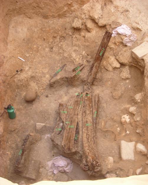
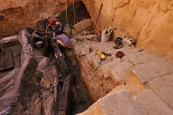
12 The collapsed wood accumulation in the wellroom of the Royal Palace of Qatna - A 3D Recostruction 7-16


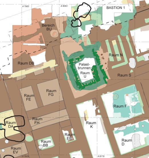
13 12 m Qatna The Well-Room U 9 m 8-16
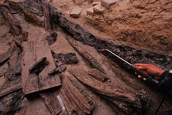
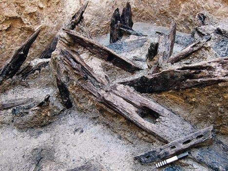


14 The waterlogged timber accumulation 9-16
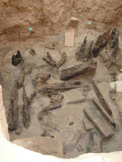
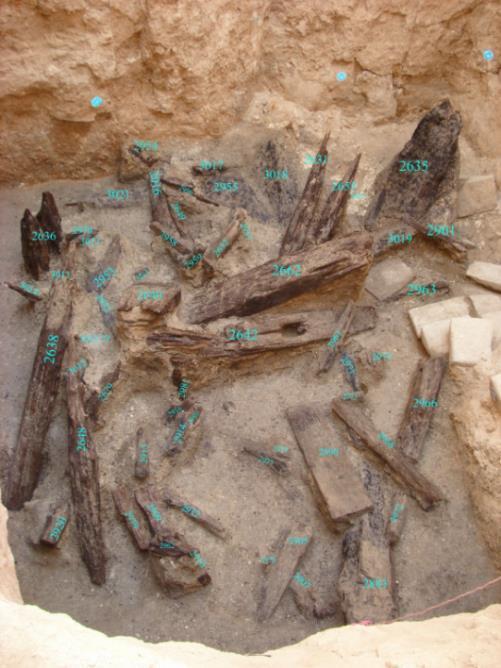
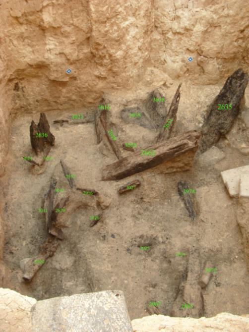
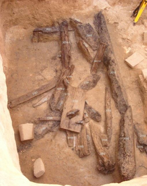
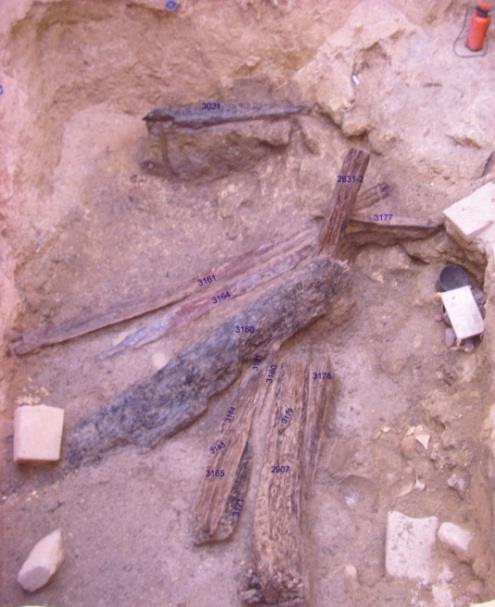
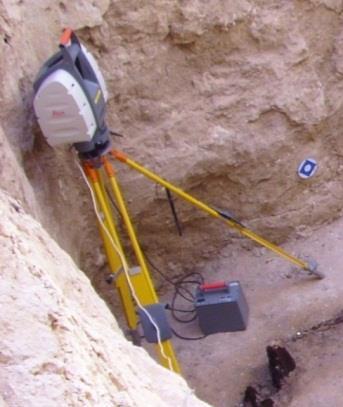
15 The 3D dokumentation with TLS in 6 Field Scan Sessions Layer 2008 Layer 1 (top Layer) Layer 2 Layer 3 HDS3000 Layer 4 Layer 5 Layer 6 (lowest Layer) Layer


16 Detailed 3D documentation of individual pieces of wood - structure from motion 3d model of a piece of wood 3D Camera positions and orientations 11-16

17 Combination of the 3D result from TLS and SFM - 3D dokumentation of the collapsed wood accumulation 12-16


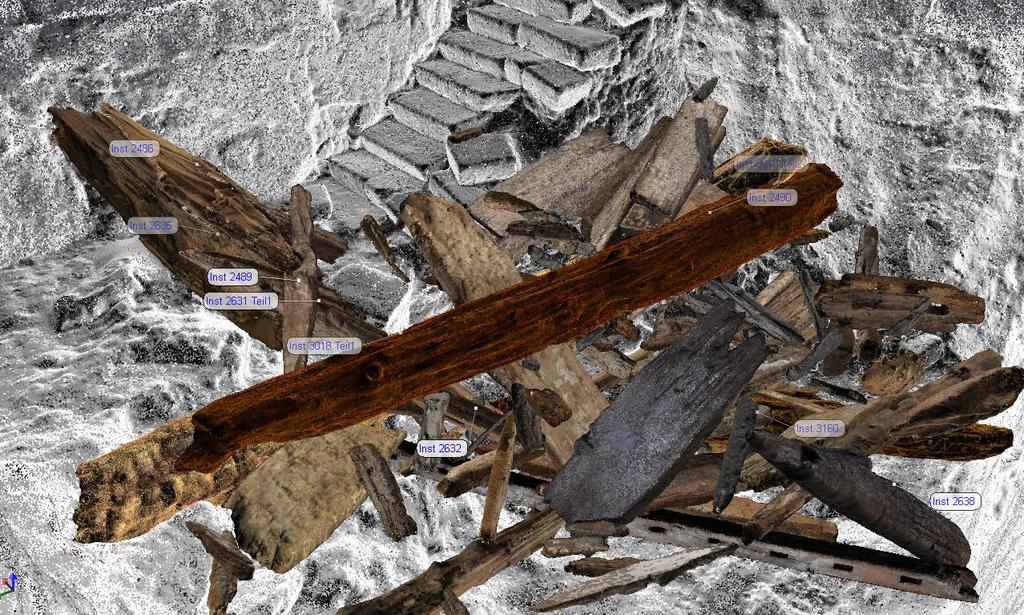
18 collapsed wood accumulation - generated from all measured layers 13-16

 3D point accuracy: 1/5 of its size 0,75 mm (measurement volume")
19 HIGH-PRECISION MEASURING TECHNIQUES - 3D acquisition of surfaces Fringe Projection Technology: photogrammtric solution equipped with an active light projection system is characterized by a stable and invariant mounting of two cameras and a pattern projector with high luminosity cameras are arranged with converging optical axes, so they see the same object part projector illuminates the object with different patterns This allows to solve correspondence problems and to calculate the spatial position of each object pixel GOM ATOS III Point spacing: 0,03 mm (measurement volume 65mm³) 3D point accuracy: 1/5 of its size 0,75 mm (measurement volume 1500mm³) 14-16
 Documentation and analysis of stone-carved Buddhist texts of the 8 th -")

 stone-carved Buddhist texts")
20 HIGH-PRECISION MEASURING TECHNIQUES - Examples of projects (Fringe projection System) Documentation and analysis of stone-carved Buddhist texts of the 8 th - 9 th Century in Sichuan, China The 3D data sets were the basis for the development of a analytical tool for a Photography Web-Atlas of a wall cutout of Scanned with stone-carved Sutra Inscriptions (cooperation 3D with model Academy of a wall of Sciences cutout with Heidelberg) stone-carved Buddhist texts Buddhist texts 15-16


21 HIGH-PRECISION MEASURING TECHNIQUES - Examples of projects (Fringe projection System) High-precision measuring techniques for the monitoring of surfaces from heritage objects (cooperation with the Institut für Steinkonservierung e.v.) Comparison between different measurement campaigns in a false color scheme 3D model 2008 Comparison: Comparison: Comparison:
22 Thank you!
Tracking for the Registration of 3D and Multispectral Datasets
 Tracking for the Registration of 3D and Multispectral Datasets C. Simon Chane 1 2 R. Schütze 2 F. Marzani 1 F. Boochs 2 csimonchane@cite-musique.fr 1 le2i, Université de Bourgogne, France 2 i3mainz, Fachhochschule
3D Terrestrial Laser Scanner Innovative Applications for 3D Documentation
 3D Terrestrial Laser Scanner Innovative Applications for 3D Documentation Rodney Chaffee Head of Sales, FARO Asia Pacific 3D Laser Scaning Market 2017 2.3 Billion $ 2012 1.3 Billion $ CAGR : > 12% Source:
COMPARISON OF LASER SCANNING, PHOTOGRAMMETRY AND SfM-MVS PIPELINE APPLIED IN STRUCTURES AND ARTIFICIAL SURFACES
 COMPARISON OF LASER SCANNING, PHOTOGRAMMETRY AND SfM-MVS PIPELINE APPLIED IN STRUCTURES AND ARTIFICIAL SURFACES 2012 ISPRS Melbourne, Com III/4, S.Kiparissi Cyprus University of Technology 1 / 28 Structure
USE THE 3D LASER SCANNING FOR DOCUMENTATION THE RIGA CATHEDRAL IN LATVIA
 USE THE 3D LASER SCANNING FOR DOCUMENTATION THE RIGA CATHEDRAL IN LATVIA Maris Kalinka, Elina Rutkovska, Department of Geomatic, Riga Technical University, Azenes 16-109, Riga, Latvia, geomatika@geomatika.lv
3D recording of archaeological excavation
 5 th International Conference Remote Sensing in Archaeology The Age of Sensing 13-15 October 2014 - Duke University 3D recording of archaeological excavation Stefano Campana UNIVERSITY of CAMBRIDGE Faculty
Evaluation of Structure from Motion (SfM) in Compact, Long Hallways
 in Compact, Long Hallways") Evaluation of Structure from Motion (SfM) in Compact, Long Hallways Structure from Motion (SfM) is an emerging technology which can generate 3D point clouds from a series of overlapping 2D images. Research
Evaluation of Structure from Motion (SfM) in Compact, Long Hallways Structure from Motion (SfM) is an emerging technology which can generate 3D point clouds from a series of overlapping 2D images. Research
High Definition Modeling of Calw, Badstrasse and its Google Earth Integration
 Master Thesis Yuanting LI High Definition Modeling of Calw, Badstrasse and its Google Earth Integration Duration of the Thesis: 6 months Completion: July, 2014 Supervisors: Prof.Dr.-Ing.Dieter Fritsch
Photogrammetry for forest inventory.
 Photogrammetry for forest inventory. Marc Pierrot Deseilligny. IGN/ENSG, France. Jonathan Lisein. Ulg Gembloux Agro-Bio Tech, Belgium. 1- Photogrammetry 2- Application to forestry 3- Tools and proposed
A COMPARISON OF SPARSE AND DENSE POINT APPROACH TO PHOTOGRAMMETRIC 3D MODELING FOR STONE TEXTURED OBJECTS (CASE STUDY: ARCHEOLOGICAL SITES) ABSTRACT
 ABSTRACT") A COMPARISON OF SPARSE AND DENSE POINT APPROACH TO PHOTOGRAMMETRIC 3D MODELING FOR STONE TEXTURED OBJECTS (CASE STUDY: ARCHEOLOGICAL SITES) Arnadi D. Murtiyoso 1, Deni Suwardhi 2 1,2 Spatial Information
A COMPARISON OF SPARSE AND DENSE POINT APPROACH TO PHOTOGRAMMETRIC 3D MODELING FOR STONE TEXTURED OBJECTS (CASE STUDY: ARCHEOLOGICAL SITES) Arnadi D. Murtiyoso 1, Deni Suwardhi 2 1,2 Spatial Information
Introduction to photogrammetry (with an underwater flavor)
") Introduction to photogrammetry (with an underwater flavor) NAS - UCY HFF Field school, Cyprus, 2016 Dimitrios Skarlatos, Assistant Professor, Cyprus University of Technology Photogrammetric vision Lab
Introduction to photogrammetry (with an underwater flavor) NAS - UCY HFF Field school, Cyprus, 2016 Dimitrios Skarlatos, Assistant Professor, Cyprus University of Technology Photogrammetric vision Lab
Gregory Walsh, Ph.D. San Ramon, CA January 25, 2011
 Leica ScanStation:: Calibration and QA Gregory Walsh, Ph.D. San Ramon, CA January 25, 2011 1. Summary Leica Geosystems, in creating the Leica Scanstation family of products, has designed and conducted
Comparing Aerial Photogrammetry and 3D Laser Scanning Methods for Creating 3D Models of Complex Objects
 Comparing Aerial Photogrammetry and 3D Laser Scanning Methods for Creating 3D Models of Complex Objects A Bentley Systems White Paper Cyril Novel Senior Software Engineer, Bentley Systems Renaud Keriven
Comparing Aerial Photogrammetry and 3D Laser Scanning Methods for Creating 3D Models of Complex Objects
 www.bentley.com Comparing Aerial Photogrammetry and 3D Laser Scanning Methods for Creating 3D Models of Complex Objects A Bentley White Paper Cyril Novel Senior Software Engineer, Bentley Systems Renaud
COSCH KR ontology the basis for a platform recommending 3D and spectral digitisation strategies
 COSCH KR ontology the basis for a platform recommending 3D and spectral digitisation strategies Stefanie Wefers, Ashish Karmacharya, Frank Boochs i3mainz -Institute for Spatial Information and Surveying
Terrestrial 3D laser scanning Practical aspects
 Terrestrial 3D laser scanning Practical aspects ISPRS WG VI/5&SC Summer School 2007 by Gregor Bilban 3D laser scanning Benefits Lower data collection costs Reduction or elimination of re-visits More accurate
Automatic Systems for Digitizing Historical Maps
 Martina Ballarin *, Caterina Balletti **, Caterina Gottardi *** Automatic Systems for Digitizing Historical Maps Keywords: digitization; robotic arm; 3D recording; photogrammetry; historical maps Summary:
Advanced Highway Maintenance and Construction Technology Research Center
 Advanced Highway Maintenance and Construction Technology Research Center Department of Mechanical and Aerospace Engineering University of California at Davis Creating Standards and Specifications for the
APPLICATION OF SFM AND LASER SCANNING TECHNOLOGY TO THE DESCRIPTION OF MOSAICS PIECE BY PIECE
 APPLICATION OF SFM AND LASER SCANNING TECHNOLOGY TO THE DESCRIPTION OF MOSAICS PIECE BY PIECE O.Ajioka a,b *, Y.Hori a a Dep. of Architecture and Urban Design, Faculty of Human-Environment Studies, Kyushu
New Sony DepthSense TM ToF Technology
 ADVANCED MATERIAL HANDLING WITH New Sony DepthSense TM ToF Technology Jenson Chang Product Marketing November 7, 2018 1 3D SENSING APPLICATIONS Pick and Place Drones Collision Detection People Counting
TERRESTRIAL LASER SYSTEM TESTING USING REFERENCE BODIES
 TERRESTRIAL LASER SYSTEM TESTING USING REFERENCE BODIES Miriam Zámečníková and Alojz Kopáčik Department of Surveying, Faculty of Civil Engineering Slovak University of Technology Email: miriam.zamecnikova@stuba.sk
EVOLUTION OF POINT CLOUD
 Figure 1: Left and right images of a stereo pair and the disparity map (right) showing the differences of each pixel in the right and left image. (source: https://stackoverflow.com/questions/17607312/difference-between-disparity-map-and-disparity-image-in-stereo-matching)
Terrestrial radar and laser scanning for deformation monitoring: first steps towards assisted radar scanning
 Terrestrial radar and laser scanning for deformation monitoring: first steps towards assisted radar scanning Daniel Wujanz 1, Frank Neitzel 1, H.P. Hebel 2, J. Linke 2, W. Busch 2 1 Chair of Geodesy and
Assessing 3D Point Cloud Fidelity of UAS SfM Software Solutions Over Varying Terrain
 Assessing 3D Point Cloud Fidelity of UAS SfM Software Solutions Over Varying Terrain Michael Schwind, Michael J. Starek (Presenter) 18th Annual JALBTCX Airborne Coastal Mapping and Charting Technical Workshop,
Computer Vision. 3D acquisition
 è Computer 3D acquisition Acknowledgement Courtesy of Prof. Luc Van Gool 3D acquisition taxonomy s image cannot currently be displayed. 3D acquisition methods Thi passive active uni-directional multi-directional
New Sony DepthSense TM ToF Technology
 ADVANCED MATERIAL HANDLING WITH New Sony DepthSense TM ToF Technology Jenson Chang Product Marketing November 7, 2018 1 3D SENSING APPLICATIONS Pick and Place Drones Collision Detection People Counting
5 member consortium o University of Strathclyde o Wideblue o National Nuclear Laboratory o Sellafield Ltd o Inspectahire
 3 year, 1.24M Innovate UK funded Collaborative Research and Development Project (Nuclear Call) o Commenced April 2015 o Follows on from a successful 6 month Innovate UK funded feasibility study 2013-2014
3D Computer Vision. Structured Light II. Prof. Didier Stricker. Kaiserlautern University.
 3D Computer Vision Structured Light II Prof. Didier Stricker Kaiserlautern University http://ags.cs.uni-kl.de/ DFKI Deutsches Forschungszentrum für Künstliche Intelligenz http://av.dfki.de 1 Introduction
Chapter 3 Image Registration. Chapter 3 Image Registration
 Chapter 3 Image Registration Distributed Algorithms for Introduction (1) Definition: Image Registration Input: 2 images of the same scene but taken from different perspectives Goal: Identify transformation
Dense 3D Reconstruction. Christiano Gava
 Dense 3D Reconstruction Christiano Gava christiano.gava@dfki.de Outline Previous lecture: structure and motion II Structure and motion loop Triangulation Wide baseline matching (SIFT) Today: dense 3D reconstruction
Close-Range. Photogrammetry. and 3D Imaging. 2nd edition. Edited by. Thomas Luhmann, Stuart Robson, Stephen Kyle. and Jan Boehm.
 Close-Range Photogrammetry and 3D Imaging 2nd edition Edited by Thomas Luhmann, Stuart Robson, Stephen Kyle and Jan Boehm De Gruyter Content 1 Introduction 1 1.1 Overview 1 1.1.1 Content 1 1.1.2 References
IMAGE ACQUISITION FOR DIGITAL PHOTOGRAMMETRY USING OF THE SHELF AND METRIC CAMERAS
 IMAGE ACQUISITION FOR DIGITAL PHOTOGRAMMETRY USING OF THE SHELF AND METRIC CAMERAS Günter Pomaska FH Bielefeld, University of Applied Sciences Artilleriestr. 9, D32427 Minden gp@imagefact.de, www.imagefact.de
Structure from Motion: High resolution DEMs at any scale using everyday equipment
 Structure from Motion: High resolution DEMs at any scale using everyday equipment Anders Damsgaard Last revision: May 20, 2014 Outline Photogrammetry Method Examples Summary Photogrammetry using SfM Production
Automatic image network design leading to optimal image-based 3D models
 Automatic image network design leading to optimal image-based 3D models Enabling laymen to capture high quality 3D models of Cultural Heritage Bashar Alsadik & Markus Gerke, ITC, University of Twente,
Artescan, 3D Scanning IPN TecBis, Edif. E Rua Pedro Nunes, Coimbra, Portugal
 1 Displacement and surface pathology monitoring of former Tejo Power Station building by combining terrestrial laser scanning, micro-geodesy, photogrammetry and GIS Adriano OLIVEIRA, João BOAVIDA, Bruno
Structured Light II. Thanks to Ronen Gvili, Szymon Rusinkiewicz and Maks Ovsjanikov
 Structured Light II Johannes Köhler Johannes.koehler@dfki.de Thanks to Ronen Gvili, Szymon Rusinkiewicz and Maks Ovsjanikov Introduction Previous lecture: Structured Light I Active Scanning Camera/emitter
3D Computer Vision Introduction. Guido Gerig CS 6320, Spring 2012
 3D Computer Vision Introduction Guido Gerig CS 6320, Spring 2012 gerig@sci.utah.edu Administrivia Classes: M & W, 1.25-2:45 Room WEB L126 Instructor: Guido Gerig gerig@sci.utah.edu (801) 585 0327 Prerequisites:
Flexible Visual Inspection. IAS-13 Industrial Forum Horizon 2020 Dr. Eng. Stefano Tonello - CEO
 Flexible Visual Inspection IAS-13 Industrial Forum Horizon 2020 Dr. Eng. Stefano Tonello - CEO IT+Robotics Spin-off of University of Padua founded in 2005 Strong relationship with IAS-LAB (Intelligent
Integrating the Generations, FIG Working Week 2008,Stockholm, Sweden June 2008
 H. Murat Yilmaz, Aksaray University,Turkey Omer Mutluoglu, Selçuk University, Turkey Murat Yakar, Selçuk University,Turkey Cutting and filling volume calculation are important issues in many engineering
3D SCANNER: is any device that
 DEFINITIONS 3D SCANNER: is any device that - collects 3D coordinates of a given region of an object surface - automatically and in a systematic pattern - at a high rate - achieving the results (i.e. 3D
ScienceDirect. The use of Optical Methods for Leak Testing Dampers
 Available online at www.sciencedirect.com ScienceDirect Procedia Engineering 69 ( 2014 ) 788 794 24th DAAAM International Symposium on Intelligent Manufacturing and Automation, 2013 The use of Optical
Dense 3D Reconstruction. Christiano Gava
 Dense 3D Reconstruction Christiano Gava christiano.gava@dfki.de Outline Previous lecture: structure and motion II Structure and motion loop Triangulation Today: dense 3D reconstruction The matching problem
Multiview Photogrammetry 3D Virtual Geology for everyone
 Multiview Photogrammetry 3D Virtual Geology for everyone A short course Marko Vrabec University of Ljubljana, Department of Geology FIRST: some background info Precarious structural measurements of fractures
THE USE OF OPTICAL METHODS FOR LEAK TESTING DAMPERS
 DAAAM INTERNATIONAL SCIENTIFIC BOOK 2013 pp. 787-794 CHAPTER 47 THE USE OF OPTICAL METHODS FOR LEAK TESTING DAMPERS TOMASIAK, J. Abstract: The present paper presents the possible use of a portable structural
PERFORMANCE CAPTURE FROM SPARSE MULTI-VIEW VIDEO
 Stefan Krauß, Juliane Hüttl SE, SoSe 2011, HU-Berlin PERFORMANCE CAPTURE FROM SPARSE MULTI-VIEW VIDEO 1 Uses of Motion/Performance Capture movies games, virtual environments biomechanics, sports science,
COMPARATIVE ANALYSIS OF 3D POINT CLOUDS GENERATED FROM A FREEWARE AND TERRESTRIAL LASER SCANNER
 COMPARATIVE ANALYSIS OF 3D POINT CLOUDS GENERATED FROM A FREEWARE AND TERRESTRIAL LASER SCANNER K.R. Dayal a, *, S. Raghavendra a, H. Pande a, P.S. Tiwari a, I. Chauhan a a Indian Institute of Remote Sensing,
Digital Preservation of the Aurelius Church and the Hirsau Museum Complex by Means of HDS and Photogrammetric Texture Mapping
 Master Thesis Ruxandra MOROSAN Ruxandra MOROSAN Digital Preservation of the Aurelius Church and the Hirsau Museum Complex by Means of HDS and Photogrammetric Texture Mapping Duration of the Thesis: 6 months
TERRESTRIAL LASER SCANNER DATA PROCESSING
 TERRESTRIAL LASER SCANNER DATA PROCESSING L. Bornaz (*), F. Rinaudo (*) (*) Politecnico di Torino - Dipartimento di Georisorse e Territorio C.so Duca degli Abruzzi, 24 10129 Torino Tel. +39.011.564.7687
The Feasibility of Structure from Motion over Planetary Bodies with Small Satellite Systems. Caleb Adams 2017 CURO Syposium
 The Feasibility of Structure from Motion over Planetary Bodies with Small Satellite Systems Caleb Adams 2017 CURO Syposium What is the UGA SSRL? Student Run Student Founded Faculty Supported NASA and UNP/AFRL
Terrestrial Laser-Scanning Universal Method or a Specialist s Tool?
 Heinz STANEK, Austria Key words: Terrestrial Laser Scanner, 3D Modeling, True Ortho Image, Cultural Heritage Documentation, 3D Visualization SUMMARY The methodology of laser scanning is in transition very
THE ETRUSCANS IN 3D: FROM SPACE TO UNDERGROUND
 THE ETRUSCANS IN 3D: FROM SPACE TO UNDERGROUND Fabio Remondino 1, Alessandro Rizzi 1, Belen Jimenez 1, Giorgio Agugiaro 1, Giorgio Baratti 1, Raffaele De Amicis 2 (1) 3D Optical Metrology (3DOM) Bruno
Automatic image-based reconstruction of historical buildings from Ayutthaya
 การประช มว ชาการว ศวกรรมโยธาแห งชาต คร งท 20 The 20 tth National Convention on Civil Engineering ว นท 8-10 กรกฎาคม 2558 จ. ชลบ ร 8-10 July 2015, Chonburi, THAILAND Automatic image-based reconstruction
GABRIELE GUIDI, PHD POLITECNICO DI MILANO, ITALY VISITING SCHOLAR AT INDIANA UNIVERSITY NOV OCT D IMAGE FUSION
 GABRIELE GUIDI, PHD POLITECNICO DI MILANO, ITALY VISITING SCHOLAR AT INDIANA UNIVERSITY NOV 2017 - OCT 2018 3D IMAGE FUSION 3D IMAGE FUSION WHAT A 3D IMAGE IS? A cloud of 3D points collected from a 3D
A Comparison of Close-Range Photogrammetry to Terrestrial Laser Scanning for Heritage Documentation
 A Comparison of Close-Range Photogrammetry to Terrestrial Laser Scanning for Heritage Documentation Heinz Rüther 1, Julian Smit 1 and Donatius Kamamba 2 1 Geomatics Division, School of Architecture, Planning
AN AUTOMATIC 3D RECONSTRUCTION METHOD BASED ON MULTI-VIEW STEREO VISION FOR THE MOGAO GROTTOES
 The International Archives of the Photogrammetry, Remote Sensing and Spatial Information Sciences, Volume XL-4/W5, 05 Indoor-Outdoor Seamless Modelling, Mapping and avigation, May 05, Tokyo, Japan A AUTOMATIC
XXV FIG International Congress KUALA LUMPUR Highly Detailed 3D Modelling of Mayan Cultural Heritage using an UAV
 XXV FIG International Congress KUALA LUMPUR 2014 Highly Detailed 3D Modelling of Mayan Cultural Heritage using an UAV Cornelis Stal, Britt Lonneville, Timothy Nuttens, Philippe De Maeyer, Alain De Wulf
A Semi-Automatic Image-Based Close Range 3D Modeling Pipeline Using a Multi-Camera Configuration
 Sensors 2012, 12, 11271-11293; doi:10.3390/s120811271 Article OPEN ACCESS sensors ISSN 1424-8220 www.mdpi.com/journal/sensors A Semi-Automatic Image-Based Close Range 3D Modeling Pipeline Using a Multi-Camera
OUTDOOR AND INDOOR NAVIGATION WITH MICROSOFT KINECT
 DICA-Dept. of Civil and Environmental Engineering Geodesy and Geomatics Section OUTDOOR AND INDOOR NAVIGATION WITH MICROSOFT KINECT Diana Pagliari Livio Pinto OUTLINE 2 The Microsoft Kinect sensor The
The Institute of Remote Sensing and Digital Earth, Chinese Academy of Sciences liqi
 Fine Deformation Monitoring of Ancient Building Based on Terrestrial Laser Scanning Technologies The Institute of Remote Sensing and Digital Earth, Chinese Academy of Sciences liqi Outline Introduce the
SIMULATION AND VISUALIZATION IN THE EDUCATION OF COHERENT OPTICS
 SIMULATION AND VISUALIZATION IN THE EDUCATION OF COHERENT OPTICS J. KORNIS, P. PACHER Department of Physics Technical University of Budapest H-1111 Budafoki út 8., Hungary e-mail: kornis@phy.bme.hu, pacher@phy.bme.hu
Simple 3D Reconstruction of Single Indoor Image with Perspe
 Simple 3D Reconstruction of Single Indoor Image with Perspective Cues Jingyuan Huang Bill Cowan University of Waterloo May 26, 2009 1 Introduction 2 Our Method 3 Results and Conclusions Problem Statement
Integrated High-Quality Acquisition of Geometry and Appearance for Cultural Heritage
 Integrated High-Quality Acquisition of Geometry and Appearance for Cultural Heritage Christopher Schwartz, Michael Weinmann, Roland Ruiters, Reinhard Klein Institute of Computer Science II Computer Graphics
3D MODELLING WITH THE SAMSUNG GEAR 360
 3D MODELLING WITH THE SAMSUNG GEAR 360 L. Barazzetti 1, M. Previtali 1, F. Roncoroni 2 1 Dept. of Architecture, Built environment and Construction engineering (ABC) Politecnico di Milano, Piazza Leonardo
Adaptive Zoom Distance Measuring System of Camera Based on the Ranging of Binocular Vision
 Adaptive Zoom Distance Measuring System of Camera Based on the Ranging of Binocular Vision Zhiyan Zhang 1, Wei Qian 1, Lei Pan 1 & Yanjun Li 1 1 University of Shanghai for Science and Technology, China
A selection of our previous clients:
 Survey Solutions Geo-Spatial Survey Solutions Ltd Contact: Tel: Email: Y X Roger Davies 07713 160041 roger.davies@geo-spatial.co.uk www.geo-spatial.co.uk A selection of our previous clients: English Heritage
A Novel Visual Pipework Inspection System
 Summan, Rahul and Jackson, William and Dobie, Gordon and MacLeod, Charles Norman and Mineo, Carmelo and West, Graeme and Offin, Douglas and Bolton, Gary and Marshall, Stephen and Lille, Alexander (2017)
CS4670: Computer Vision
 CS4670: Computer Vision Noah Snavely Lecture 6: Feature matching and alignment Szeliski: Chapter 6.1 Reading Last time: Corners and blobs Scale-space blob detector: Example Feature descriptors We know
3D MESH RECONSTRUCTION USING PHOTOGRAMMETRY EX. 1 VISUAL SFM + MESHLAB. Afonso Maria C. F. A. Gonçalves
 3D MESH RECONSTRUCTION USING PHOTOGRAMMETRY EX. 1 VISUAL SFM + MESHLAB Afonso Maria C. F. A. Gonçalves 20130528 ADVANCED STUDIES PROGRAM IN COMPUTATION APPLIED TO ARCHITECTURE, URBAN PLANNING AND DESIGN
Introduction to 3D Machine Vision
 Introduction to 3D Machine Vision 1 Many methods for 3D machine vision Use Triangulation (Geometry) to Determine the Depth of an Object By Different Methods: Single Line Laser Scan Stereo Triangulation
MODELING OF THE PLAN DA MATTUN ARCHAEOLOGICAL SITE USING A COMBINATION OF DIFFERENT SENSORS
 MODELING OF THE PLAN DA MATTUN ARCHAEOLOGICAL SITE USING A COMBINATION OF DIFFERENT SENSORS D. Novák, P. Tokarczyk*, P.W. Theiler Institute of Geodesy and Photogrammetry, ETH Zürich, 8093 Zürich, Switzerland
PWO: Faster to Finished Sheet Metal Forming Tools with Optical Metrology
 Application Note PWO: Faster to Finished Sheet Metal Forming Tools with Optical Metrology Company s place of business: Oberkirch GOM system: ATOS Triple Scan GOM software: GOM Inspect Professional Sector:
3D Photography: Active Ranging, Structured Light, ICP
 3D Photography: Active Ranging, Structured Light, ICP Kalin Kolev, Marc Pollefeys Spring 2013 http://cvg.ethz.ch/teaching/2013spring/3dphoto/ Schedule (tentative) Feb 18 Feb 25 Mar 4 Mar 11 Mar 18 Mar
Geospatial database for heritage building conservation
 IOP Conf. Series: Earth and Environmental Science 18 (2014) 012087 doi:10.1088/1755-1315/18/1/012087 Geospatial database for heritage building conservation W N F W A Basir1,3, H Setan1, Z M ajid1, A Chong2
NEW PERSPECTIVES OF POINT CLOUDS COLOR MANAGEMENT THE DEVELOPMENT OF TOOL IN MATLAB FOR APPLICATIONS IN CULTURAL HERITAGE
 NEW PERSPECTIVES OF POINT CLOUDS COLOR MANAGEMENT THE DEVELOPMENT OF TOOL IN MATLAB FOR APPLICATIONS IN CULTURAL HERITAGE M. Pepe a, *, S. Ackermann, L. Fregonese, C. Achille a Polytechnic of Milan, 20133,
Photo based Terrain Data Acquisition & 3D Modeling
 Photo based Terrain Data Acquisition & 3D Modeling June 7, 2013 Howard Hahn Kansas State University Partial funding by: KSU Office of Research and Sponsored Programs Introduction: Need Application 1 Monitoring
TERRESTRIAL AND NUMERICAL PHOTOGRAMMETRY 1. MID -TERM EXAM Question 4
 TERRESTRIAL AND NUMERICAL PHOTOGRAMMETRY 1. MID -TERM EXAM Question 4 23 November 2001 Two-camera stations are located at the ends of a base, which are 191.46m long, measured horizontally. Photographs
Calibration of IRS-1C PAN-camera
 Calibration of IRS-1C PAN-camera Karsten Jacobsen Institute for Photogrammetry and Engineering Surveys University of Hannover Germany Tel 0049 511 762 2485 Fax -2483 Email karsten@ipi.uni-hannover.de 1.
5 member consortium o University of Strathclyde o Wideblue o National Nuclear Laboratory o Sellafield Ltd o Inspectahire
 Summan, Rahul and Mathur, Neha and Dobie, Gordon and West, Graeme and Marshall, Stephen and Mineo, Carmelo and MacLeod, Charles Norman and Pierce, Stephen and Kerr, William (2016) Mosaicing for automated
COMPUTER VISION TOOLS FOR 3D MODELLING IN ARCHAEOLOGY
 1 COMPUTER VISION TOOLS FOR 3D MODELLING IN ARCHAEOLOGY M. Lo Brutto *, P. Meli Dept. of Civil, Environmental, Aerospace and Materials Engineering University of Palermo, Viale delle Scienze, 90128 Palermo,
CAPTURING REALITY AT CENTRE BLOCK
 CAPTURING REALITY AT CENTRE BLOCK C. Boulanger a, C. Ouimet a, N. Yeomans a a Heritage Conservation Services, Public Services and Procurement Canada, 30 Victoria St, Gatineau, Quebec KEY WORDS: Structure
FARO As-Built for AutoCAD Software Versatile Reality to CAD Solutions
 FARO As-Built for AutoCAD Software Versatile Reality to CAD Solutions FARO As-Built for Autodesk Revit Creating Efficiencies in Scan Data Extraction for BIM FARO As-Built for AutoCAD Software TM Versatile
Scan-Copter 2.0. Strength by Cooperation. a product of 4D-IT GmbH & von-oben e.u. High-Quality. 3D Documentation. supported by UAV
 Scan-Copter 2.0 a product of 4D-IT GmbH & von-oben e.u. Peter Dorninger Dominik Krawczyk Clemens Nothegger Strength by Cooperation 3D Documentation Multimedia Applications Data Processing Sensor Integration
HIGH PRECISION SURVEY AND ALIGNMENT OF LARGE LINEAR COLLIDERS - HORIZONTAL ALIGNMENT -
 HIGH PRECISION SURVEY AND ALIGNMENT OF LARGE LINEAR COLLIDERS - HORIZONTAL ALIGNMENT - A. Herty, J. Albert 1 Deutsches Elektronen-Synchrotron DESY, Hamburg, Germany with international partners * 1. INTRODUCTION
INVESTIGATION INTO THE USE OF ACTION CAMERAS IN THE DOCUMENTATION OF ARCHITECTURAL DETAILS - THE CASE STUDY OF A BAROQUE CHAMBER.
 INVESTIGATION INTO THE USE OF ACTION CAMERAS IN THE DOCUMENTATION OF ARCHITECTURAL DETAILS - THE CASE STUDY OF A BAROQUE CHAMBER. J. Markiewicz 1*, S. Łapiński 2, M. Pilarska 1, R. Bieńkowski 3, A. Kaliszewska
Investigating the Applicability of Standard Software Packages for Laser Scanner Based Deformation Analyses
 Investigating the Applicability of Standard Software Packages for Laser Scanner Based Deformation Analyses Presented at the FIG Working Week 2017, May 29 - June 2, 2017 in Helsinki, Finland FIG Working
A METHOD OF 3D MEASUREMENT AND RECONSTRUCTION FOR CULTURAL RELICS IN MUSEUMS
 A METHOD OF 3D MEASUREMENT AND RECONSTRUCTION FOR CULTURAL RELICS IN MUSEUMS Shunyi Zheng a, Yang Zhou a, *, Rongyong Huang a, Langming Zhou a, Xuan Xu a, Chengyi Wang b a School of Remote Sensing and
INTEGRATED MODELING SYSTEMS FOR 3D VISION
 INTEGRATED MODELING SYSTEMS FOR 3D VISION A. Guarnieri a, R. M. Levy b, A. Vettore a a CIRGEO Interdept. Research Center of Geomatics, University of Padova, Italy - cirgeo@unipd.it b Faculty of Environmental
Trimble VISION Positions from Pictures
 Trimble VISION Positions from Pictures This session will cover What Is Trimble VISION? Trimble VISION Portfolio What Do you Need? How Does It Work & How Accurate Is It? Applications Resources Trimble VISION
Body Trunk Shape Estimation from Silhouettes by Using Homologous Human Body Model
 Body Trunk Shape Estimation from Silhouettes by Using Homologous Human Body Model Shunta Saito* a, Makiko Kochi b, Masaaki Mochimaru b, Yoshimitsu Aoki a a Keio University, Yokohama, Kanagawa, Japan; b
Centre for Digital Image Measurement and Analysis, School of Engineering, City University, Northampton Square, London, ECIV OHB
 HIGH ACCURACY 3-D MEASUREMENT USING MULTIPLE CAMERA VIEWS T.A. Clarke, T.J. Ellis, & S. Robson. High accuracy measurement of industrially produced objects is becoming increasingly important. The techniques
MAPPING WITHOUT GROUND CONTROL POINTS: DOES IT WORK?
 MAPPING WITHOUT GROUND CONTROL POINTS: DOES IT WORK? BACKGROUND The economic advantages of Structure from Motion (SfM) mapping without any ground control points have motivated us to investigate an approach
Structured light 3D reconstruction
 Structured light 3D reconstruction Reconstruction pipeline and industrial applications rodola@dsi.unive.it 11/05/2010 3D Reconstruction 3D reconstruction is the process of capturing the shape and appearance
Deformation Monitoring Trials Using a Leica HDS3000
 Deformation Monitoring Trials Using a Leica HDS3000 Gethin ROBERTS, Matthew BADDLEY, UK Key words: Laser scanning, deformation monitoring. SUMMARY The use of laser scanners for deformation monitoring is
Laser Systems for Patient Alignment
 Laser Systems for Patient Alignment GALAXY Patient TOPOGRAPHY Laser System Page: 2 Date: 28 March 2009 The GALAXY System NEW METHOD FOR HIGHER ALIGNMENT ACCURACY. Patient Positioning System for Linac Simulator
TERRESTRIAL LASER SCANNER TECHNIC AS A METHOD FOR IDENTIFICATION AREAS OF SLOPS
 77 TERRESTRIAL LASER SCANNER TECHNIC AS A METHOD FOR IDENTIFICATION AREAS OF SLOPS Bartłomiej Ćmielewski, Bernard Kontny Institute of Geodesy and Geoinformatics, Wroclaw University of Environmental and
PhotoScan. Fully automated professional photogrammetric kit
 PhotoScan Fully automated professional photogrammetric kit Agisoft PhotoScan is a stand-alone photogrammetric software solution for automatic generation of dense point clouds, textured polygonal models,
Robust extraction of image correspondences exploiting the image scene geometry and approximate camera orientation
 Robust extraction of image correspondences exploiting the image scene geometry and approximate camera orientation Bashar Alsadik a,c, Fabio Remondino b, Fabio Menna b, Markus Gerke a, George Vosselman
Estimation of elevation dependent deformations of a parabolic reflector of a large radio telescope
 . Estimation of elevation dependent deformations of a parabolic reflector of a large radio telescope 1 Christoph Holst & Heiner Kuhlmann JISDM, 2-4 November 2011, Hong Kong, China . Motivation Laser Scanner
Testing GoPro for 3D model reconstruction in narrow spaces
 ACTA IMEKO ISSN: 2221 870X September 2016, Volume 5, Number 2, 64 70 Testing GoPro for 3D model reconstruction in narrow spaces Fausta Fiorillo 1, Marco Limongiello 1, Belén Jiménez Fernández Palacios
OLERDOLA S CAVE, CATALONIA, PAST AND PRESENT: A VIRTUAL REALITY RECONSTRUCTION FROM TERRESTRIAL LASER SCANNER AND GIS DATA
 LM VC OLERDOLA S CAVE, CATALONIA, PAST AND PRESENT: A RECONSTRUCTION FROM TERRESTRIAL AND GIS DATA B. Pucci a, A. Marambio a a Virtual City Modelling Lab, Politecnical University of Catalonia, 08012 Barcelona,
Tutorial (Intermediate level): Dense Cloud Classification and DTM generation with Agisoft PhotoScan Pro 1.1
: Dense Cloud Classification and DTM generation with Agisoft PhotoScan Pro 1.1") Tutorial (Intermediate level): Dense Cloud Classification and DTM generation with Agisoft PhotoScan Pro 1.1 This tutorial illustrates how to perform dense point cloud classification in manual and automatic
Tutorial (Intermediate level): Dense Cloud Classification and DTM generation with Agisoft PhotoScan Pro 1.1 This tutorial illustrates how to perform dense point cloud classification in manual and automatic