Terrestrial Laser Scanning: Applications in Civil Engineering Pauline Miller
|
|
|
- William Bond
- 5 years ago
- Views:
Transcription
1 Terrestrial Laser Scanning: Applications in Civil Engineering Pauline Miller School of Civil Engineering & Geosciences Newcastle University
2 Overview Laser scanning overview Research applications geometric accuracy assessment coastal monitoring slope stability assessment Waveform laser scanning developments Integration with other data sources Remaining challenges Conclusions
![Laser Scanning: Main Aspects collection of mass point cloud [xyz + intensity] for each target (point) intensity = strength of returned signal influenced by](/docs-images/92/110253598/images/3-1.jpg "target reflectivity most systems collected digital imagery aids in interpretation useful for mapping (lidar is blind technique) full waveform scanning (more")
3 Laser Scanning: Main Aspects collection of mass point cloud [xyz + intensity] for each target (point) intensity = strength of returned signal influenced by target reflectivity most systems collected digital imagery aids in interpretation useful for mapping (lidar is blind technique) full waveform scanning (more later...)


4 System Development Terrestrial laser scanning Optech parallel, but separate development Airborne laser scanning (lidar)
 natural extension of")


5 Mobile Mapping Systems (MMS) natural extension of lidar & TLS tight integration of scanner, GPS, IMU support dynamic applications e.g. road, rail, boat Optech
6 Laser Scanning Research at Newcastle University
7 Mobile Mapping Systems MMS have been active research topic for ~ 20 years development driven by: airborne systems offer poor coverage of urban environments TLS can partially overcome, but only over limited spatial extents demand for responsive data capture MMS have only recently become commercial reality systems are still maturing requirement for improved understanding of accuracy/precision

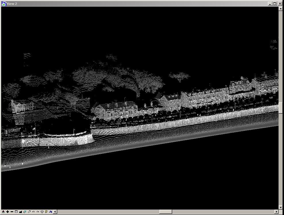
8 Assessing Geometric Quality StreetMapper system 3 laser profilers mounted on high sided van integrated with GPS IMU commissioned by Ordnance Survey analysis of processed data i.e. customer ready
9 Test Sites & Datasets two test sites (Newcastle upon Tyne) 1. low density residential housing => good GPS scenario 2. narrow valley: tall, tightly packed industrial buildings => worst case GPS scenario 5 forward, 5 reverse passes at each site (precision analysis) reference measurements RTK & static GPS measurements for vertical and planimetric assessment
 no significant difference Example N.B.")
10 Precision Assessment Test site 1: m (95%) Test site 2: m (95%) no significant difference Example N.B. poorer precision along kerb lines
11 Accuracy Assessment Elevation Accuracy (m) Planimetric Accuracy (m) Test Site Test Site Elevation poorer results for test site 1 some correspondence with flightlines originating in narrow streets Planimetry corner of road markings used as check points poorer than expected some difficulties in identifying points in scan data
12 Summary of Findings positional quality difficult to independently assess analysis of individual flightlines shows largest RMSE errors in main urban canyons in test site 2 route planning should be considered as important aspect quality control measures are required as routine to ensure specifications are met results demonstrate that MMS can be successfully used even in worst case GPS environments

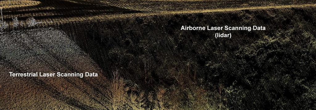
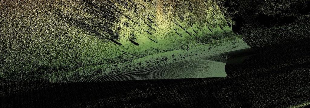
13 MMS for Coastal Monitoring AEROcontrol GPS/IMU Riegl LMS Q560 airborne lidar system Vibration mount Power and storage GrafNav, AEROoffice and TerraScan for processing


14 Testing at Filey Bay 7km beach section Single pass coverage

15
16
17 Data Validation Test Area 1 Test Area 2 Standard deviation (m) Root mean square error (m) Minimum (m) Maximum (m) Mean (m) No. Points validated using post processed RTK GPS data results influenced by: occlusions cliff face orientation (relative to scanner) vegetation effects
18 Summary of Findings well suited to rapid assessment of dynamic environment more affordable than airborne techniques (e.g. lidar) increasingly suitable as cliffs tend to vertical However: limited by access, tides, foreshore terrain orientation of cliff face can cause occlusions defences, buildings, etc may cause obstructions/occlusions


19 TLS for Transport Corridors Slope Stability assessing deformation and slope stability investigating sensitivity of TLS repeat scanning procedure Haltwhistle Road Embankment


20 TLS derived Elevation Differences October December 2007 Detection of low magnitude instability (soil creep, surface run off)

21 Waveform Laser Scanning Record complete waveform of backscattered echo T1 T2 Tn Source: Geolas Consulting


22 Newcastle Waveform Scanning Research Bristol test site: BMX circuit Mixed landscape types (320m 275m)


23 Conventional ground classification algorithms Digital Surface Model DTM 3 Iteration angle DTM 6 Iteration angle 23


24 Smoothing of discontinuities DTM with waveform information 3 Iteration angle 6 Iteration angle Inclusion of low vegetation

25 Waveform Digitising & MMS waveform digitising now a feature of MMS advantages for airborne systems clear (DTMs, vegetation) terrestrial systems have smaller footprint > less impact? greatest benefits may be in vegetated areas: First & last returns only All waveform returns
26 Integration with Other Datasets imagery often comes as standard improved mapping of features and edges textural information for (e.g.) building modelling airborne lidar complementary data source overcome occlusions and provide wider area coverage vector mapping data (e.g. OS MasterMap) inclusion of breaklines (e.g. kerbs) & features (e.g. walls) essential for accurate flood modelling
27

 no explicit feature")

28 Remaining Challenges Greatest challenge is transforming data > information enormous data volumes (esp. with waveform) no explicit feature information (unlike imagery) building/feature extraction remain major research challenges fully automated workflow some way off
29 Conclusions MMS offer great potential for rapid, detailed mapping numerous applications technique still in its infancy evaluation of quality (accuracy, precision) should be core element of every survey particularly important for many hydrological analysis tasks GPS/IMU solution occupies major portion of error budget mission and route planning important


30 ISPRS Commission V Mid Term Symposium Close Range Image Measurement Techniques 22 nd 24 th June 2010 Newcastle upon Tyne newcastle2010.org

31 Contact Details Pauline Miller phone: /5042 School of Civil Engineering & Geosciences PLS Research Team
VEHICLE BASED WAVEFORM LASER SCANNING IN A COASTAL ENVIRONMENT
 VEHICLE BASED WAVEFORM LASER SCANNING IN A COASTAL ENVIRONMENT D. M. Barber *, J. P. Mills School of Civil Engineering and Geosciences, Newcastle University, Newcastle upon Tyne, NE1 7RU, UK * d.m.barber@ncl.ac.uk
N.J.P.L.S. An Introduction to LiDAR Concepts and Applications
 N.J.P.L.S. An Introduction to LiDAR Concepts and Applications Presentation Outline LIDAR Data Capture Advantages of Lidar Technology Basics Intensity and Multiple Returns Lidar Accuracy Airborne Laser
Aerial and Mobile LiDAR Data Fusion
 Creating Value Delivering Solutions Aerial and Mobile LiDAR Data Fusion Dr. Srini Dharmapuri, CP, PMP What You Will Learn About LiDAR Fusion Mobile and Aerial LiDAR Technology Components & Parameters Project
LIDAR MAPPING FACT SHEET
 1. LIDAR THEORY What is lidar? Lidar is an acronym for light detection and ranging. In the mapping industry, this term is used to describe an airborne laser profiling system that produces location and
MONITORING COASTAL INSTABILITY USING AIRBORNE AND TERRESTRIAL LIDAR
 MONITORING COASTAL INSTABILITY USING AIRBORNE AND TERRESTRIAL LIDAR A Coastal Challenge Monitoring coastlines is a challenging task, especially due to the typically inaccessible nature of the coastal terrain.
SPAR, ELMF 2013, Amsterdam. Laser Scanning on the UK Highways Agency Network. Hamish Grierson Blom Uk
 SPAR, ELMF 2013, Amsterdam Laser Scanning on the UK Highways Agency Network Hamish Grierson Blom Uk www.blomasa.com www.blom-uk.co.uk Blom UK Part of the Blom Group Blom Group - Europe s largest aerial
Multi-ray photogrammetry: A rich dataset for the extraction of roof geometry for 3D reconstruction
 Multi-ray photogrammetry: A rich dataset for the extraction of roof geometry for 3D reconstruction Andrew McClune, Pauline Miller, Jon Mills Newcastle University David Holland Ordnance Survey Background
2. POINT CLOUD DATA PROCESSING
 Point Cloud Generation from suas-mounted iphone Imagery: Performance Analysis A. D. Ladai, J. Miller Towill, Inc., 2300 Clayton Road, Suite 1200, Concord, CA 94520-2176, USA - (andras.ladai, jeffrey.miller)@towill.com
Laser scanners with echo digitization for full waveform analysis
 Laser scanners with echo digitization for full waveform analysis Peter Rieger, Andreas Ullrich, Rainer Reichert RIEGL Laser Measurement Systems GmbH DI Peter Rieger Project Management RIEGL LMS GmbH A-3580
Advanced point cloud processing
 Advanced point cloud processing George Vosselman ITC Enschede, the Netherlands INTERNATIONAL INSTITUTE FOR GEO-INFORMATION SCIENCE AND EARTH OBSERVATION Laser scanning platforms Airborne systems mounted
Integrated Multi-Source LiDAR and Imagery
 Figure 1: AirDaC aerial scanning system Integrated Multi-Source LiDAR and Imagery The derived benefits of LiDAR scanning in the fields of engineering, surveying, and planning are well documented. It has
BUILDING DETECTION AND STRUCTURE LINE EXTRACTION FROM AIRBORNE LIDAR DATA
 BUILDING DETECTION AND STRUCTURE LINE EXTRACTION FROM AIRBORNE LIDAR DATA C. K. Wang a,, P.H. Hsu a, * a Dept. of Geomatics, National Cheng Kung University, No.1, University Road, Tainan 701, Taiwan. China-
An Introduction to Lidar & Forestry May 2013
 An Introduction to Lidar & Forestry May 2013 Introduction to Lidar & Forestry Lidar technology Derivatives from point clouds Applied to forestry Publish & Share Futures Lidar Light Detection And Ranging
UTILIZACIÓN DE DATOS LIDAR Y SU INTEGRACIÓN CON SISTEMAS DE INFORMACIÓN GEOGRÁFICA
 UTILIZACIÓN DE DATOS LIDAR Y SU INTEGRACIÓN CON SISTEMAS DE INFORMACIÓN GEOGRÁFICA Aurelio Castro Cesar Piovanetti Geographic Mapping Technologies Corp. (GMT) Consultores en GIS info@gmtgis.com Geographic
Mobile LiDAR for Ground Applications. Spar 2006, March Paul Mrstik, Terrapoint Canada Inc. Craig Glennie, Terrapoint USA LLC
 Mobile LiDAR for Ground Applications Spar 2006, March 27 2006 Paul Mrstik, Terrapoint Canada Inc. Craig Glennie, Terrapoint USA LLC Agenda Introduction to Terrapoint What is mobile LiDAR? Advantages of
Measuring the potential impact of offshore mining on coastal instability through integrated time-series laser scanning and photography
 Measuring the potential impact of offshore mining on coastal instability through integrated time-series laser scanning and photography by Neil Slatcher, Roberto Vargas, Chris Cox and Liene Starka, 3D Laser
Hamilton County Enhances GIS Base Mapping with 1-foot Contours
 Hamilton County Enhances GIS Base Mapping with 1-foot Contours Presented by Larry Stout, Hamilton County GIS Manager Brad Fugate, Woolpert Inc. Today s Presentation Hamilton County s 2004 Base Mapping
UAS based laser scanning for forest inventory and precision farming
 UAS based laser scanning for forest inventory and precision farming M. Pfennigbauer, U. Riegl, P. Rieger, P. Amon RIEGL Laser Measurement Systems GmbH, 3580 Horn, Austria Email: mpfennigbauer@riegl.com,
LIDAR Workshop IPSRS Commission 1
 LIDAR Workshop IPSRS Commission 1 2-Jul-2007, Ljubliana, Slovenia Arthur Rohrbach, Leica Geosystems, Switzerland Presentation topics 1. Basics of Airborne LIDAR Sensing Technology 2. Typical Applications
 Die im Vortrag gezeigten Video Clips können unter http://www.streetmapper.net/gallery/animations.htm heruntergeladen werden. Stuttgart, 19. Juni 2007 Mobile Mapping - 3D-Datenerfassung kommt in Fahrt Jens
LIDAR and Terrain Models: In 3D!
 LIDAR and Terrain Models: In 3D! Stuart.green@teagasc.ie http://www.esri.com/library/whitepapers/pdfs/lidar-analysis-forestry.pdf http://www.csc.noaa.gov/digitalcoast/_/pdf/refinement_of_topographic_lidar_to_create_a_bare_e
CHANGE DETECTION FOR TOPOGRAPHIC MAPPING USING THREE- DIMENSIONAL DATA STRUCTURES
 CHANGE DETECTION FOR TOPOGRAPHIC MAPPING USING THREE- DIMENSIONAL DATA STRUCTURES D. M. Barber a, D. Holland b, J. P. Mills c a DSTL, Porton Down, Salisbury, SP4 OJQ, UK dbarber@dstl.gov.uk b Ordnance
New Requirements for the Relief in the Topographic Databases of the Institut Cartogràfic de Catalunya
 New Requirements for the Relief in the Topographic Databases of the Institut Cartogràfic de Catalunya Blanca Baella, Maria Pla Institut Cartogràfic de Catalunya, Barcelona, Spain Abstract Since 1983 the
HAWAII KAUAI Survey Report. LIDAR System Description and Specifications
 HAWAII KAUAI Survey Report LIDAR System Description and Specifications This survey used an Optech GEMINI Airborne Laser Terrain Mapper (ALTM) serial number 06SEN195 mounted in a twin-engine Navajo Piper
Watershed Sciences 4930 & 6920 ADVANCED GIS
 Watershed Sciences 4930 & 6920 ADVANCED GIS TERRESTRIAL LASER SCANNING (AKA GROUND BASED LIDAR) Joe Wheaton PURPOSE OF TODAY S DEMONSTRATION Introduce you to TLS Demystify TLS & LiDaR TODAY S PLAN I. What
AN INTEGRATED SENSOR ORIENTATION SYSTEM FOR AIRBORNE PHOTOGRAMMETRIC APPLICATIONS
 AN INTEGRATED SENSOR ORIENTATION SYSTEM FOR AIRBORNE PHOTOGRAMMETRIC APPLICATIONS M. J. Smith a, *, N. Kokkas a, D.W.G. Park b a Faculty of Engineering, The University of Nottingham, Innovation Park, Triumph
Quinnipiac Post Flight Aerial Acquisition Report
 Quinnipiac Post Flight Aerial Acquisition Report August 2011 Post-Flight Aerial Acquisition and Calibration Report FEMA REGION 1 Quinnipiac Watershed, Connecticut, Massachusesetts FEDERAL EMERGENCY MANAGEMENT
Investigating the Structural Condition of Individual Trees using LiDAR Metrics
 Investigating the Structural Condition of Individual Trees using LiDAR Metrics Jon Murray 1, George Alan Blackburn 1, Duncan Whyatt 1, Christopher Edwards 2. 1 Lancaster Environment Centre, Lancaster University,
Validation of Aerial LiDAR Products For Transportation Applications
 Creating Value Delivering Solutions Validation of Aerial LiDAR Products For Transportation Applications Dr. Srini Dharmapuri, CP, PMP Michael Baker Jr., Inc. Lauren Little, PE Alaska DOT Public Facility
Overview. 1. Aerial LiDAR in Wisconsin (20 minutes) 2. Demonstration of data in CAD (30 minutes) 3. High Density LiDAR (20 minutes)
 2. Demonstration of data in CAD (30 minutes) 3. High Density LiDAR (20 minutes)") Overview 1. Aerial LiDAR in Wisconsin (20 minutes) 2. Demonstration of data in CAD (30 minutes) 3. High Density LiDAR (20 minutes) 4. Aerial lidar technology advancements (15 minutes) 5. Q & A 1. Aerial
Overview 1. Aerial LiDAR in Wisconsin (20 minutes) 2. Demonstration of data in CAD (30 minutes) 3. High Density LiDAR (20 minutes) 4. Aerial lidar technology advancements (15 minutes) 5. Q & A 1. Aerial
Airborne Laser Survey Systems: Technology and Applications
 Abstract Airborne Laser Survey Systems: Technology and Applications Guangping HE Lambda Tech International, Inc. 2323B Blue Mound RD., Waukesha, WI-53186, USA Email: he@lambdatech.com As mapping products
A METHOD TO PREDICT ACCURACY OF LEAST SQUARES SURFACE MATCHING FOR AIRBORNE LASER SCANNING DATA SETS
 A METHOD TO PREDICT ACCURACY OF LEAST SQUARES SURFACE MATCHING FOR AIRBORNE LASER SCANNING DATA SETS Robert Pâquet School of Engineering, University of Newcastle Callaghan, NSW 238, Australia (rpaquet@mail.newcastle.edu.au)
INTEGRATION OF FULL-WAVEFORM INFORMATION INTO THE AIRBORNE LASER SCANNING DATA FILTERING PROCESS
 INTEGRATION OF FULL-WAVEFORM INFORMATION INTO THE AIRBORNE LASER SCANNING DATA FILTERING PROCESS Y. -C. Lin* and J. P. Mills School of Civil Engineering and Geosciences, Newcastle University, Newcastle
Bringing Singapore to life in 3D
 Bringing Singapore to life in 3D Dr Victor Khoo, Deputy Director Singapore Land Authority Bringing Singapore to life in 3D ESRI Singapore UC 2016 Dr. Victor Khoo Singapore Land Authority SLA 2016 RESTRICTED
LiDAR Remote Sensing Data Collection: Yaquina and Elk Creek Watershed, Leaf-On Acquisition
 LiDAR Remote Sensing Data Collection: Yaquina and Elk Creek Watershed, Leaf-On Acquisition Submitted by: 4605 NE Fremont, Suite 211 Portland, Oregon 97213 April, 2006 Table of Contents LIGHT DETECTION
LiForest Software White paper. TRGS, 3070 M St., Merced, 93610, Phone , LiForest
 0 LiForest LiForest is a platform to manipulate large LiDAR point clouds and extract useful information specifically for forest applications. It integrates a variety of advanced LiDAR processing algorithms
Merging LiDAR Data with Softcopy Photogrammetry Data
 Merging LiDAR Data with Softcopy Photogrammetry Data Cindy McCallum WisDOT\Bureau of Technical Services Surveying & Mapping Section Photogrammetry Unit Overview Terms and processes Why use data from LiDAR
CLASSIFICATION OF NONPHOTOGRAPHIC REMOTE SENSORS
 CLASSIFICATION OF NONPHOTOGRAPHIC REMOTE SENSORS PASSIVE ACTIVE DIGITAL CAMERA THERMAL (e.g. TIMS) VIDEO CAMERA MULTI- SPECTRAL SCANNERS VISIBLE & NIR MICROWAVE HYPERSPECTRAL (e.g. AVIRIS) SLAR Real Aperture
Aalborg Universitet. Published in: Accuracy Publication date: Document Version Early version, also known as pre-print
 Aalborg Universitet A method for checking the planimetric accuracy of Digital Elevation Models derived by Airborne Laser Scanning Høhle, Joachim; Øster Pedersen, Christian Published in: Accuracy 2010 Publication
Redefining Airborne LiDAR Introduction to RIEGL LMS in Airborne LiDAR
 Redefining Airborne LiDAR Introduction to RIEGL LMS in Airborne LiDAR Andres Vargas Integration Systems Engineer LAGF Mexico City, Mexico September 23th, 2014 1 Airborne Laser Scanning History and Evolution
Lecture 11. LiDAR, RADAR
 NRMT 2270, Photogrammetry/Remote Sensing Lecture 11 Calculating the Number of Photos and Flight Lines in a Photo Project LiDAR, RADAR Tomislav Sapic GIS Technologist Faculty of Natural Resources Management
Assimilation of Break line and LiDAR Data within ESRI s Terrain Data Structure (TDS) for creating a Multi-Resolution Terrain Model
 for creating a Multi-Resolution Terrain Model") Assimilation of Break line and LiDAR Data within ESRI s Terrain Data Structure (TDS) for creating a Multi-Resolution Terrain Model Tarig A. Ali Department of Civil Engineering American University of Sharjah,
Assimilation of Break line and LiDAR Data within ESRI s Terrain Data Structure (TDS) for creating a Multi-Resolution Terrain Model Tarig A. Ali Department of Civil Engineering American University of Sharjah,
RIEGL LMS-Q780. The Versatile, High Altitude Airborne LIDAR Sensor
 RIEGL LMS-Q780 4700m 400kHz The full waveform airborne laser scanner offers great versatility, accuracy, and data quality. The scanner enables you to successfully deliver your projects with industry leading
ALS40 Airborne Laser Scanner
 ALS40 Airborne Laser Scanner Airborne LIDAR for Professionals High Performance Laser Scanning Direct Measurement of Ground Surface from the Air The ALS40 Airborne Laser Scanner measures the topography
ENY-C2005 Geoinformation in Environmental Modeling Lecture 4b: Laser scanning
 1 ENY-C2005 Geoinformation in Environmental Modeling Lecture 4b: Laser scanning Petri Rönnholm Aalto University 2 Learning objectives To recognize applications of laser scanning To understand principles
Methods to survey, process, and georeference terrestrial LIDAR data to map regional seacliff erosion with uncertainty analysis
 Methods to survey, process, and georeference terrestrial LIDAR data to map regional seacliff erosion with uncertainty analysis Michael Olsen, Liz Johnstone, Adam Young, Scott Ashford, Neal Driscoll, and
THE RAILMAPPER - A DEDICATED MOBILE LIDAR MAPPING SYSTEM FOR RAILWAY NETWORKS
 THE RAILMAPPER - A DEDICATED MOBILE LIDAR MAPPING SYSTEM FOR RAILWAY NETWORKS Jens Kremer & Albrecht Grimm IGI mbh, Langenauer Straße 46, 57223 Kreuztal, Germany (j.kremer, a.grimm)@igi-systems.com ICWG
EXTRACTING SURFACE FEATURES OF THE NUECES RIVER DELTA USING LIDAR POINTS INTRODUCTION
 EXTRACTING SURFACE FEATURES OF THE NUECES RIVER DELTA USING LIDAR POINTS Lihong Su, Post-Doctoral Research Associate James Gibeaut, Associate Research Professor Harte Research Institute for Gulf of Mexico
APPENDIX E2. Vernal Pool Watershed Mapping
 APPENDIX E2 Vernal Pool Watershed Mapping MEMORANDUM To: U.S. Fish and Wildlife Service From: Tyler Friesen, Dudek Subject: SSHCP Vernal Pool Watershed Analysis Using LIDAR Data Date: February 6, 2014
W D-0049/004 EN
 September 21, 2011 Contact Ground Survey Report, Lidar Accuracy Report, & Project Report New Madrid Seismic Zone Northeast of Memphis, Tennessee Contract Number: W91278-09D-0049/004 EN Project: C-10-026
Table of Contents. 1. Overview... 1
 LIDAR REMOTE SENSING DATA COLLECTION: Diiabllo Canyon,, CA Prreparred by: : Prreparred fforr: : WSII Corrval lliss Offffi ice 5117 SW 2 nndd Stt,, Suitte 400 Corrval lliss,, OR 97333 Updaatteed Maayy 33,,,
Tree height measurements and tree growth estimation in a mire environment using digital surface models
 Tree height measurements and tree growth estimation in a mire environment using digital surface models E. Baltsavias 1, A. Gruen 1, M. Küchler 2, P.Thee 2, L.T. Waser 2, L. Zhang 1 1 Institute of Geodesy
Terrain Modeling and Mapping for Telecom Network Installation Using Scanning Technology. Maziana Muhamad
 Terrain Modeling and Mapping for Telecom Network Installation Using Scanning Technology Maziana Muhamad Summarising LiDAR (Airborne Laser Scanning) LiDAR is a reliable survey technique, capable of: acquiring
RIEGL LMS-Q780. The Versatile, High Altitude Airborne LIDAR Sensor
 RIEGL LMS-Q780 3050m 400kHz The full waveform airborne laser scanner offers great versatility, accuracy, and data quality. The scanner enables you to successfully deliver your projects with industry leading
2010 LiDAR Project. GIS User Group Meeting June 30, 2010
 2010 LiDAR Project GIS User Group Meeting June 30, 2010 LiDAR = Light Detection and Ranging Technology that utilizes lasers to determine the distance to an object or surface Measures the time delay between
Airborne Laser Scanning: Remote Sensing with LiDAR
 Airborne Laser Scanning: Remote Sensing with LiDAR ALS / LIDAR OUTLINE Laser remote sensing background Basic components of an ALS/LIDAR system Two distinct families of ALS systems Waveform Discrete Return
Backscatter Coefficient as an Attribute for the Classification of Full-waveform Airborne Laser Scanning Data in Urban Areas
 Backscatter Coefficient as an Attribute for the Classification of Full-waveform Airborne Laser Scanning Data in Urban Areas Cici Alexander 1, Kevin Tansey 1, Jörg Kaduk 1, David Holland 2, Nicholas J.
Leica ALS70. Airborne Laser Scanners Performance for diverse Applications
 Leica ALS70 Airborne Laser Scanners Performance for diverse Applications Three Models, One Result. Highest Productivity in all Applications. Imagine an affordable 500 khz pulse rate city-mapping LIDAR
Presented at the FIG Congress 2018, May 6-11, 2018 in Istanbul, Turkey
 Presented at the FIG Congress 2018, May 6-11, 2018 in Istanbul, Turkey Evangelos MALTEZOS, Charalabos IOANNIDIS, Anastasios DOULAMIS and Nikolaos DOULAMIS Laboratory of Photogrammetry, School of Rural
CE 59700: LASER SCANNING
 Digital Photogrammetry Research Group Lyles School of Civil Engineering Purdue University, USA Webpage: http://purdue.edu/ce/ Email: ahabib@purdue.edu CE 59700: LASER SCANNING 1 Contact Information Instructor:
FOOTPRINTS EXTRACTION
 Building Footprints Extraction of Dense Residential Areas from LiDAR data KyoHyouk Kim and Jie Shan Purdue University School of Civil Engineering 550 Stadium Mall Drive West Lafayette, IN 47907, USA {kim458,
Reality Check: Processing LiDAR Data. A story of data, more data and some more data
 Reality Check: Processing LiDAR Data A story of data, more data and some more data Red River of the North Red River of the North Red River of the North Red River of the North Introduction and Background
LiDAR data pre-processing for Ghanaian forests biomass estimation. Arbonaut, REDD+ Unit, Joensuu, Finland
 LiDAR data pre-processing for Ghanaian forests biomass estimation Arbonaut, REDD+ Unit, Joensuu, Finland Airborne Laser Scanning principle Objectives of the research Prepare the laser scanning data for
Quality Assurance and Quality Control Procedures for Survey-Grade Mobile Mapping Systems
 Quality Assurance and Quality Control Procedures for Survey-Grade Mobile Mapping Systems Latin America Geospatial Forum November, 2015 Agenda 1. Who is Teledyne Optech 2. The Lynx Mobile Mapper 3. Mobile
Terrestrial GPS setup Fundamentals of Airborne LiDAR Systems, Collection and Calibration. JAMIE YOUNG Senior Manager LiDAR Solutions
 Terrestrial GPS setup Fundamentals of Airborne LiDAR Systems, Collection and Calibration JAMIE YOUNG Senior Manager LiDAR Solutions Topics Terrestrial GPS reference Planning and Collection Considerations
NATIONWIDE POINT CLOUDS AND 3D GEO- INFORMATION: CREATION AND MAINTENANCE GEORGE VOSSELMAN
 NATIONWIDE POINT CLOUDS AND 3D GEO- INFORMATION: CREATION AND MAINTENANCE GEORGE VOSSELMAN OVERVIEW National point clouds Airborne laser scanning in the Netherlands Quality control Developments in lidar
Advanced Highway Maintenance and Construction Technology Research Center
 Advanced Highway Maintenance and Construction Technology Research Center Department of Mechanical and Aerospace Engineering University of California at Davis Creating Standards and Specifications for the
Automated Extraction of Buildings from Aerial LiDAR Point Cloud and Digital Imaging Datasets for 3D Cadastre - Preliminary Results
 Automated Extraction of Buildings from Aerial LiDAR Point Cloud and Digital Imaging Datasets for 3D Pankaj Kumar 1*, Alias Abdul Rahman 1 and Gurcan Buyuksalih 2 ¹Department of Geoinformation Universiti
REGISTRATION OF AIRBORNE LASER DATA TO SURFACES GENERATED BY PHOTOGRAMMETRIC MEANS. Y. Postolov, A. Krupnik, K. McIntosh
 REGISTRATION OF AIRBORNE LASER DATA TO SURFACES GENERATED BY PHOTOGRAMMETRIC MEANS Y. Postolov, A. Krupnik, K. McIntosh Department of Civil Engineering, Technion Israel Institute of Technology, Haifa,
A New Way to Control Mobile LiDAR Data
 A New Way to Control Mobile LiDAR Data Survey control has always been a critically important issue when conducting mobile LiDAR surveys. While the accuracies currently being achieved with the most capable
Automatic DTM Extraction from Dense Raw LIDAR Data in Urban Areas
 Automatic DTM Extraction from Dense Raw LIDAR Data in Urban Areas Nizar ABO AKEL, Ofer ZILBERSTEIN and Yerach DOYTSHER, Israel Key words: LIDAR, DSM, urban areas, DTM extraction. SUMMARY Although LIDAR
INTEGRATION OF MOBILE LASER SCANNING DATA WITH UAV IMAGERY FOR VERY HIGH RESOLUTION 3D CITY MODELING
 INTEGRATION OF MOBILE LASER SCANNING DATA WITH UAV IMAGERY FOR VERY HIGH RESOLUTION 3D CITY MODELING Xianfeng Huang 1,2 Armin Gruen 1, Rongjun Qin 1 Tangwu Du 1, Wei Fang 1 1 Singapore-ETH Center, Future
Geometric validation of a mobile laser scanning system for urban applications
 Geometric validation of a mobile laser scanning system for urban applications Haiyan Guan 1, Jonathan Li 1,2, Yongtao Yu 2, Yan Liu 2 1 GeoSTARS Lab, Faculty of Environment, University of Waterloo, 200
Calibrated Full-Waveform Airborne Laser Scanning for 3D Object Segmentation
 Remote Sens. 2014, 6, 4109-4132; doi:10.3390/rs6054109 Article OPEN ACCESS remote sensing ISSN 2072-4292 www.mdpi.com/journal/remotesensing Calibrated Full-Waveform Airborne Laser Scanning for 3D Object
Municipal Projects in Cambridge Using a LiDAR Dataset. NEURISA Day 2012 Sturbridge, MA
 Municipal Projects in Cambridge Using a LiDAR Dataset NEURISA Day 2012 Sturbridge, MA October 15, 2012 Jeff Amero, GIS Manager, City of Cambridge Presentation Overview Background on the LiDAR dataset Solar
Outline of Presentation. Introduction to Overwatch Geospatial Software Feature Analyst and LIDAR Analyst Software
 Outline of Presentation Automated Feature Extraction from Terrestrial and Airborne LIDAR Presented By: Stuart Blundell Overwatch Geospatial - VLS Ops Co-Author: David W. Opitz Overwatch Geospatial - VLS
A DATA DRIVEN METHOD FOR FLAT ROOF BUILDING RECONSTRUCTION FROM LiDAR POINT CLOUDS
 A DATA DRIVEN METHOD FOR FLAT ROOF BUILDING RECONSTRUCTION FROM LiDAR POINT CLOUDS A. Mahphood, H. Arefi *, School of Surveying and Geospatial Engineering, College of Engineering, University of Tehran,
Airborne LiDAR Data Acquisition for Forestry Applications. Mischa Hey WSI (Corvallis, OR)
") Airborne LiDAR Data Acquisition for Forestry Applications Mischa Hey WSI (Corvallis, OR) WSI Services Corvallis, OR Airborne Mapping: Light Detection and Ranging (LiDAR) Thermal Infrared Imagery 4-Band
Airborne LiDAR Data Acquisition for Forestry Applications Mischa Hey WSI (Corvallis, OR) WSI Services Corvallis, OR Airborne Mapping: Light Detection and Ranging (LiDAR) Thermal Infrared Imagery 4-Band
2-4 April 2019 Taets Art and Event Park, Amsterdam CLICK TO KNOW MORE
 Co-Host Host 2-4 April 2019 Taets Art and Event Park, Amsterdam CLICK TO KNOW MORE Presentation Outline review modern survey methodologies available to support railway requirements measuring everything
StreetMapper 360 & StreetMapper Portable
 StreetMapper 360 & StreetMapper Portable 11th February 2010 Dr. Chris Cox & Mr. Olaf Gross 3D Laser Mapping LIDAR Specialists StreetMapper Distributor for RIEGL (UK, Ireland, Southern Africa) Terrasolid
NEXTMap World 10 Digital Elevation Model
 NEXTMap Digital Elevation Model Intermap Technologies, Inc. 8310 South Valley Highway, Suite 400 Englewood, CO 80112 10012015 NEXTMap (top) provides an improvement in vertical accuracy and brings out greater
Integration of intensity information and echo distribution in the filtering process of LIDAR data in vegetated areas
 Integration of intensity information and echo distribution in the filtering process of LIDAR data in vegetated areas J. Goepfert, U. Soergel, A. Brzank Institute of Photogrammetry and GeoInformation, Leibniz
3D Data Acquisition in Tunnels Optimizing Track Time Using Terrestrial Mobile LiDAR. Scanning. Michael R. Frecks, PLS.
 3D Data Acquisition in Tunnels Optimizing Track Time Using Terrestrial Mobile LiDAR Scanning Michael R. Frecks, PLS President/CEO AREMA 2013 1207 Understanding mobile 3D LiDAR? light detection and ranging
LiDAR Remote Sensing Data Collection: Salmon River Study Area, Oregon
 LiDAR Remote Sensing Data Collection: Salmon River Study Area, Oregon Submitted to: Barbara Ellis-Sugai USDA Forest Service Siuslaw National Forest 4077 SW Research Way Corvallis, Oregon 541.750.7056 Submitted
A New Direction in GIS Data Collection or Why Are You Still in the Field?
 GeoAutomation The Mobile Mapping System Survey-Enabled Imagery A New Direction in GIS Data Collection or Why Are You Still in the Field? Presentation to: URISA BC GIS Technology Showcase January 19, 2011
Data Acquisition; Maintenance, and Dissemination
 Data Acquisition; Maintenance, and Dissemination Amar Nayegandhi, CP, CMS(RS), GISP Director of Remote Sensing Dewberry December 4, 2014 About MAPPS + MAPPS is the only national association of private
Experiments on Generation of 3D Virtual Geographic Environment Based on Laser Scanning Technique
 Experiments on Generation of 3D Virtual Geographic Environment Based on Laser Scanning Technique Jie Du 1, Fumio Yamazaki 2 Xiaoyong Chen 3 Apisit Eiumnoh 4, Michiro Kusanagi 3, R.P. Shrestha 4 1 School
The Effect of Changing Grid Size in the Creation of Laser Scanner Digital Surface Models
 The Effect of Changing Grid Size in the Creation of Laser Scanner Digital Surface Models Smith, S.L 1, Holland, D.A 1, and Longley, P.A 2 1 Research & Innovation, Ordnance Survey, Romsey Road, Southampton,
Open Pit Mines. Terrestrial LiDAR and UAV Aerial Triangulation for. Figure 1: ILRIS at work
 Terrestrial LiDAR and UAV Aerial Triangulation for Open Pit Mines Figure 1: ILRIS at work Figure 2: Geo-Copter X-8000 taking off ay what you will about the past few years, it has produced some useful tools
IMPROVING THE ACCURACY OF DIGITAL TERRAIN MODELS
 STUDIA UNIV. BABEŞ BOLYAI, INFORMATICA, Volume XLV, Number 1, 2000 IMPROVING THE ACCURACY OF DIGITAL TERRAIN MODELS GABRIELA DROJ Abstract. The change from paper maps to GIS, in various kinds of geographical
HEURISTIC FILTERING AND 3D FEATURE EXTRACTION FROM LIDAR DATA
 HEURISTIC FILTERING AND 3D FEATURE EXTRACTION FROM LIDAR DATA Abdullatif Alharthy, James Bethel School of Civil Engineering, Purdue University, 1284 Civil Engineering Building, West Lafayette, IN 47907
TerraMatch. Introduction
 TerraMatch Introduction Error sources Interior in LRF Why TerraMatch? Errors in laser distance measurement Scanning mirror errors Exterior in trajectories Errors in position (GPS) Errors in orientation
Chapters 1 7: Overview
 Chapters 1 7: Overview Photogrammetric mapping: introduction, applications, and tools GNSS/INS-assisted photogrammetric and LiDAR mapping LiDAR mapping: principles, applications, mathematical model, and
Mobile Mapping Solutions for Ohio s Integrated Transportation Network. Brian Foster, CP
 Mobile Mapping Solutions for Ohio s Integrated Transportation Network Brian Foster, CP About Woolpert Established in 1911 Over 600 Professionals 25 Offices $12,000,000 invested in new technology in last
Plantation Resource Mapping using LiDAR
 IFA Symposium Improving Plantation Productivity Mt Gambier, 12-14 May 2014 Field Day Tour Plantation Resource Mapping using LiDAR Christine Stone (NSW DPI) and Jan Rombouts (ForestrySA) Airborne Laser
Lidar Sensors, Today & Tomorrow. Christian Sevcik RIEGL Laser Measurement Systems
 Lidar Sensors, Today & Tomorrow Christian Sevcik RIEGL Laser Measurement Systems o o o o Online Waveform technology Stand alone operation no field computer required Remote control through wireless network
Performance Evaluation of Optech's ALTM 3100: Study on Geo-Referencing Accuracy
 Performance Evaluation of Optech's ALTM 3100: Study on Geo-Referencing Accuracy R. Valerie Ussyshkin, Brent Smith, Artur Fidera, Optech Incorporated BIOGRAPHIES Dr. R. Valerie Ussyshkin obtained a Ph.D.
Cooperating Technical Partners Information Exchange. LIDAR QA/QC and Extracting Building Footprints
 Cooperating Technical Partners Information Exchange LIDAR QA/QC and Extracting Building Footprints Audio and Web Settings Participation Open and hide your control panel using the orange arrow button at
LiDAR REMOTE SENSING DATA COLLECTION BISCUIT FIRE STUDY AREA, OREGON
 LiDAR REMOTE SENSING DATA COLLECTION BISCUIT FIRE STUDY AREA, OREGON Oblique view in the Biscuit Fire Study Area: Above Ground ESRI Grid (1-meter resolution) derived from all LiDAR points Submitted to:
Geospatial Engineering Problems & Solutions Associated With NDP Roads, Tunnelling & Civil Engineering Projects Use of HDS Leica Laser Scanners
 Geospatial Engineering Problems & Solutions Associated With NDP Roads, Tunnelling & Civil Engineering Projects Use of HDS Leica Laser Scanners Laser Scanning Laser Scanning is a method of collecting large