OVERVIEW OF BUILDING RESEARCH AT THE APPLIED GEOTECHNOLOGIES
|
|
|
- Allyson Dean
- 5 years ago
- Views:
Transcription
1 PhD and Postdoc research OVERVIEW OF BUILDING RESEARCH AT THE APPLIED GEOTECHNOLOGIES Lucía Díaz Vilariño Delft, December 2016
2 Index The Applied Geotechnologies Research Group PhD research: from point clouds to gbxml. Postdoc research: point clouds for accessibility diagnosis and path planning in indoors/outdoors.
3 Index The Applied Geotechnologies Research Group PhD research: from point clouds to gbxml. Postdoc research: point clouds for accessibility diagnosis and path planning in indoors/outdoors.


4 The Applied Geotechnologies Research Group P. Arias H. Lorenzo B. Riveiro H. Gzlez-Jorge J. Martínez M. Solla I. Puente S. Lagüela L. Diaz-Vilariño B. Conde A. Fernández E. González N. Caparrini C. Caamaño M. Cabaleiro
5 Index The Applied Geotechnologies Research Group PhD research: from point clouds to gbxml. Postdoc research: point clouds for accessibility diagnosis and path planning in indoors/outdoors.


6 From point clouds to gbxml PhD Research PhD Thesis (2015): Geomatic techniques for the generation of semantically-rich building models for energy analysis purposes Point clouds Automatic processing gbxml Figure. Point cloud Figure. Resulting model imported in Sketchup.
7 Why gbxml? PhD Research The Green Building XML schema, or "gbxml", was developed to facilitate the transfer of building information stored in CAD-based building information models, enabling interoperability between disparate building design and engineering analysis software tools. ( NEWS August 1, 2016 Over 40 BIM and Building Analysis Software Tools Worldwide Now Support gbxml (Autodesk, Trimble, Graphisoft, Bentley, etc) (TAS, Energy Plus, etc.)
 Curved surfaces solved as a set of planar surfaces")
8 Why gbxml? PhD Research Geometry Geometry highly simplified Building elements as Surfaces Each surface defined by 4 boundary points (Cartesian Coordinates) Curved surfaces solved as a set of planar surfaces Openings as rectangles perfectly oriented A building as a set of enclosed spaces. Topology Spaces Adjacency Interior Building Elements Adjacency Openings are Contained by Walls Semantics Figure. gbxml model Karlsruhe Institute of Technology To energy analysis purposes: materials, heating systems, weather, orientation, etc.
9 Point cloud processing PhD Research Point clouds Envelope Reconstruction Opening Reconstruction Space reconstruction gbxml
 all segmented regions, b) ceiling and floor, c) walls,")

10 Envelope reconstruction PhD Research Point cloud Segmentation Regions Classification Figure: a) all segmented regions, b) ceiling and floor, c) walls, d) Obstacle class Ceiling Wall Floor Obstacle Topology extraction Intersection Building Envelope Figure: Parametric model of the envelope after topology extraction and intersection
11 Opening reconstruction PhD Research Wall boundary points Wall regions 2D rotation Rasterization Morphology Edge detection GHT Reprojection Openings Figure: Results of window (right) and door (left) detection. From up to down: raster image, raster submitted to salt and pepper filter and edge image,and edge image with openings in green.


12 Resulting models PhD Research Figure: gbxml models visualized in Sketchup (EnergyPlus plugin)


 Sensors, 15(2), pp.")

13 Closed doors as a special case PhD Research Applying the previous methodology to orthoimages. Distinguishing doors from other objects with the same size and shape Figure: Histograms point-to-plane From: Díaz-Vilariño, L., Khoshelham, K., Martínez-Sánchez, J., Arias, P. 3D modeling of building indoor spaces and closed doors from imagery and point clouds(2015) Sensors, 15(2), pp From: Díaz-Vilariño, L., Martínez-Sánchez, J., Lagüela, S., Armesto, J., Khoshelham, K Door recognition in cluttered building interiors using imagery and LiDAR data. ISPRS Archives, 40 (5),


14 Column segmentation PhD Research To segment round-cross section and rectangular cross-section columns under different conditions of data completeness( not interesting for energy analysis purposes) From: Díaz-Vilariño, L., Conde, B., Lagüela, S., Lorenzo, H., Automatic Detection and Segmentation of Columns in As-Built Buildings from Point Clouds. Remote Sensing, 7, pp


15 Indoor space reconstruction: grammar-based PhD Research Grammar is the set of rules governing the composition of elements from simpler units. Linguistics: phrases, words, etc. Architecture: columns, façades, etc.


16 Indoor space reconstruction: grammar-based PhD Research Example: Palladian indoor designs Characterized by: Repetition Regularity Creativity Andrea Palladio ( )
17 Indoor space reconstruction: grammar-based PhD Research Rule 1:Makeagridof rectangularspaces Repetition Regularity Rule 2:Collapse someof thewalls Creativity


18 Indoor space reconstruction: grammar-based PhD Research Rule 1:placeacuboid If therearepointsonitsceiling Rule 2:connecttwocuboids If theyarenotseparatedbyawall Rule 3:mergetwocuboids If theyhaveacommonface Manhattan-World Structures

19 Indoor space reconstruction: grammar-based PhD Research


20 Enriching models with thermal data PhD Research Use infrared thermography for the calculation of U-values of the enclosure in a nondestructive way. Integrate semantic and geometric information into a model, validated according to gbxml specifications.


21 PhD research: point clouds for energy analysis PhD Research H2020-FTIPilot ENGINENCY A Holistic System for Building Inspection and Energy Efficiency Management (Fast Track to Innovation pilot)
22 Index The Applied Geotechnologies Research Group PhD research: from point clouds to gbxml. Postdoc research: point clouds for accessibility diagnosis and path planning in indoors/outdoors.


23 Postdoc Research Concept Postdoc Project ( ): Accessibility diagnosis and path planning in indoor/outdoor scenes from point clouds Point clouds Automatic processing Building models Semantic modelling for different purposes Different geometry of interest Different meaning semantic Extension to indoors and outdoors
24 Index The Applied Geotechnologies Research Group PhD research: from point clouds to gbxml. Postdoc research: point clouds for accessibility diagnosis and path planning in indoors/outdoors.
25 Indoors Postdoc Research Díaz-Vilariño, L., Boguslawski, P., Khoshelham, K., Lorenzo, H., and Mahdjoubi, L. Indoor navigation from point clouds: 3D modelling and obstacle detection, ISPRS Archives, 2016, XLI-B4,

26 Indoors Postdoc Research Initial position Figure: Example of an initial network in a three-room building with 5 doors.
27 Indoors Postdoc Research An obstacle is defined by the existence of a set of 3D points interrupting the trajectory defined by a path.

28 Indoors Postdoc Research Dijkstra algorithm is used for path-finding: the shortest-route. Routes are submitted to obstacle detection. When an obstacle is detected, the boundary polygon is added to the navigable network and excludedfrom navigation. Links inside the polygon area are excluded from navigation. The process iterates until no obstacles are found. From: oundary.html

 Destination node Node A -2.236-2.")
")
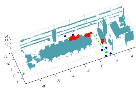
29 Case study: an academic room from University of Vigo Postdoc Research Videoconference room (a) Origin node X (m) Y (m) Destination node Node A Closest door Node B Figure: Buffer size for (a) non-disabled and (b) wheelchair people.

30 Results Postdoc Research
31 Results Postdoc Research
32 Index The Applied Geotechnologies Research Group PhD research: from point clouds to gbxml. Postdoc research: point clouds for accessibility diagnosis and path planning in indoors/outdoors.

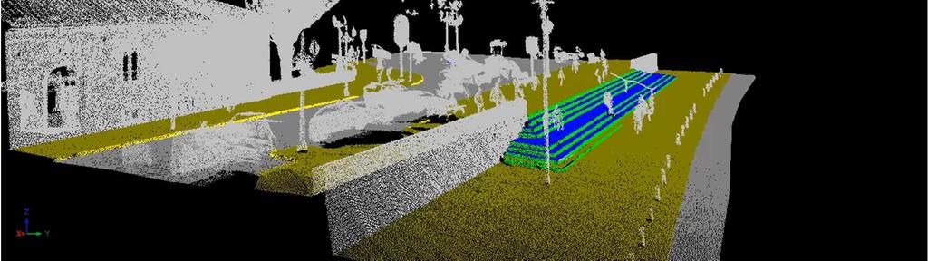
33 Outdoors Postdoc Research An approach for automatic classification of urban ground elements from 3D point clouds. Start urban point clouds Planar segmentation and refinement Preliminary geometric classification Final topologic classification urban classified elements End


34 Segmentation Postdoc Research Start urban point clouds Planar segmentation Split Merge Coplanar segmentation Road-Sidewalk segmentation urban planar elements End
35 Geometric preliminary classification Postdoc Research Planar regions 0º - 15º Tilt 60º-90º Horizontal Vertical Width Heigh <1.2m >1.2m <25cm >25cm tread sidewalk riser curb HVE Geometric candidates
36 Outdoors Postdoc Research Adjacency analysis Comparison with a graph dictionary

37 Results Postdoc Research

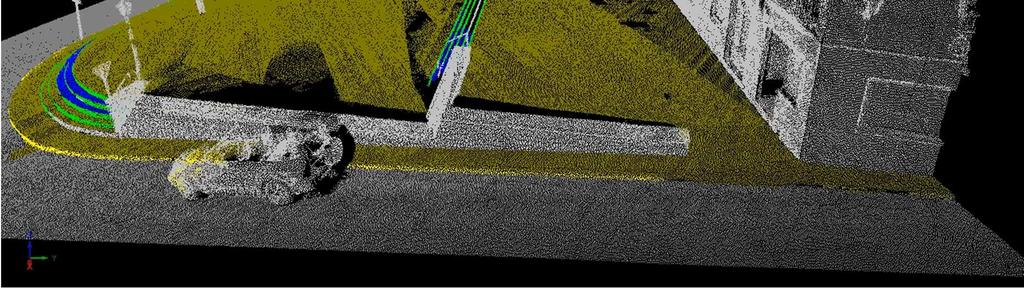
38 Results Postdoc Research
39 References K Khoshelham, L Díaz-Vilariño, 3D Modelling of interior spaces: Learning the language of indoor architecture, 2014, ISPRS Archives, XL.5: S Lagüela, L Díaz-Vilariño, J Armesto, P Arias, Non-destructive approach for the generation and thermal characterization of an as-built BIM, 2014, Construction and Building Materials 51, L Díaz-Vilariño, K Khoshelham, J Martínez-Sánchez, P Arias, 3D modeling of building indoor spaces and closed doors from imagery and point clouds, 2015, Sensors 15(2), L Díaz-Vilariño, B Conde, S Lagüela, H Lorenzo, Automatic Detection and Segmentation of Columns in As-Built Buildings from Point Clouds, 2015, Remote Sensing 7(11), Indoor navigation from point clouds: 3D modelling and obstacle detection L. Díaz-Vilariño, P. Boguslawski, K. Khoshelham, H. Lorenzo, L. Mahdjoubi, Indoor navigation from point clouds: 3D modelling and obstacle detection, 2016, ISPRS Archives, XLI-B4,
40 PhD and Postdoc research OVERVIEW OF BUILDING RESEARCH AT THE APPLIED GEOTECHNOLOGIES Lucía Díaz Vilariño Delft, December 2016
INDOOR NAVIGATION FROM POINT CLOUDS: 3D MODELLING AND OBSTACLE DETECTION
 INDOOR NAVIGATION FROM POINT CLOUDS: 3D MODELLING AND OBSTACLE DETECTION L. Díaz-Vilariño a,d *, P. Boguslawski b, K. Khoshelham c, H. Lorenzo d, L. Mahdjoubi b, a Dept. of Carthographic and Land Engineering,
3D modeling of interior spaces: Learning the language of indoor architecture. Kourosh Khoshelham Lucia Díaz-Vilariño
 3D modeling of interior spaces: Learning the language of indoor architecture Kourosh Khoshelham Lucia Díaz-Vilariño NEED FOR 3D INDOOR MODELS Crisis management in large public buildings Automated route
Extracting topological relations between indoor spaces from point clouds
 Delft University of Technology Extracting topological relations between indoor spaces from point clouds Tran, H.; Khoshelham, K.; Kealy, A.; Díaz-Vilariño, Lucía DOI 10.5194/isprs-annals-IV-2-W4-401-2017
DOOR RECOGNITION IN CLUTTERED BUILDING INTERIORS USING IMAGERY AND LIDAR DATA
 DOOR RECOGNITION IN CLUTTERED BUILDING INTERIORS USING IMAGERY AND LIDAR DATA L. Díaz-Vilariño a, *, J. Martínez-Sánchez a, S. Lagüela a, J. Armesto a, K. Khoshelham b a Applied Geotechnologies Research
Delft University of Technology. Indoor modelling from SLAM-based laser scanner Door detection to envelope reconstruction
 Delft University of Technology Indoor modelling from SLAM-based laser scanner Door detection to envelope reconstruction Díaz-Vilariño, Lucía; Verbree, Edward; Zlatanova, Sisi; Diakite, Abdoulaye DOI 10.5194/isprs-archives-XLII-2-W7-345-2017
INDOOR 3D MODEL RECONSTRUCTION TO SUPPORT DISASTER MANAGEMENT IN LARGE BUILDINGS Project Abbreviated Title: SIMs3D (Smart Indoor Models in 3D)
") INDOOR 3D MODEL RECONSTRUCTION TO SUPPORT DISASTER MANAGEMENT IN LARGE BUILDINGS Project Abbreviated Title: SIMs3D (Smart Indoor Models in 3D) PhD Research Proposal 2015-2016 Promoter: Prof. Dr. Ir. George
INDOOR 3D MODEL RECONSTRUCTION TO SUPPORT DISASTER MANAGEMENT IN LARGE BUILDINGS Project Abbreviated Title: SIMs3D (Smart Indoor Models in 3D) PhD Research Proposal 2015-2016 Promoter: Prof. Dr. Ir. George
Permanent Structure Detection in Cluttered Point Clouds from Indoor Mobile Laser Scanners (IMLS)
") Permanent Structure Detection in Cluttered Point Clouds from NCG Symposium October 2016 Promoter: Prof. Dr. Ir. George Vosselman Supervisor: Michael Peter Problem and Motivation: Permanent structure reconstruction,
Permanent Structure Detection in Cluttered Point Clouds from NCG Symposium October 2016 Promoter: Prof. Dr. Ir. George Vosselman Supervisor: Michael Peter Problem and Motivation: Permanent structure reconstruction,
AUTOMATIC GENERATION OF INDOOR NAVIGABLE SPACE USING A POINT CLOUD AND ITS SCANNER TRAJECTORY
 AUTOMATIC GENERATION OF INDOOR NAVIGABLE SPACE USING A POINT CLOUD AND ITS SCANNER TRAJECTORY B. R. Staats a, A. A. Diakité b, R. L. Voûte c,d, S. Zlatanova b, a Master of Science Geomatics, Faculty of
AN EVALUATION FRAMEWORK FOR BENCHMARKING INDOOR MODELLING METHODS
 AN EVALUATION FRAMEWORK FOR BENCHMARKING INDOOR MODELLING METHODS K. Khoshelham 1, H. Tran 1, L. Díaz-Vilariño 2, M. Peter 3, Z. Kang 4, D. Acharya 1 1 Dept. of Infrastructure Engineering, University of
Methods for Automatically Modeling and Representing As-built Building Information Models
 NSF GRANT # CMMI-0856558 NSF PROGRAM NAME: Automating the Creation of As-built Building Information Models Methods for Automatically Modeling and Representing As-built Building Information Models Daniel
PEDESTRIAN PATHFINDING IN URBAN ENVIRONMENTS: PRELIMINARY RESULTS
 PEDESTRIAN PATHFINDING IN URBAN ENVIRONMENTS: PRELIMINARY RESULTS G.López-Pazos a, J.Balado b,1, L. Díaz-Vilariño b,c, P. Arias b, M. Scaioni d a School of Industrial Engineering, Campus Lagoas-Marcosende,
BUILDING MODEL RECONSTRUCTION FROM DATA INTEGRATION INTRODUCTION
 BUILDING MODEL RECONSTRUCTION FROM DATA INTEGRATION Ruijin Ma Department Of Civil Engineering Technology SUNY-Alfred Alfred, NY 14802 mar@alfredstate.edu ABSTRACT Building model reconstruction has been
Semantic Interpretation of Mobile Laser Scanner Point Clouds in Indoor Scenes Using Trajectories
 1 2 3 4 5 6 7 8 9 10 11 12 13 14 15 16 17 18 19 20 21 22 23 24 25 26 27 28 29 30 31 32 33 34 35 36 37 38 39 40 41 Article Semantic Interpretation of Mobile Laser Scanner Point Clouds in Indoor Scenes Using
Exploiting Indoor Mobile Laser Scanner Trajectories for Interpretation of Indoor Scenes
 Exploiting Indoor Mobile Laser Scanner Trajectories for Interpretation of Indoor Scenes March 2018 Promoter: Prof. Dr. Ir. George Vosselman Supervisor: Michael Peter 1 Indoor 3D Model Reconstruction to
User-Guided Dimensional Analysis of Indoor Scenes Using Depth Sensors
 User-Guided Dimensional Analysis of Indoor Scenes Using Depth Sensors Yong Xiao a, Chen Feng a, Yuichi Taguchi b, and Vineet R. Kamat a a Department of Civil and Environmental Engineering, University of
Building Reliable 2D Maps from 3D Features
 Building Reliable 2D Maps from 3D Features Dipl. Technoinform. Jens Wettach, Prof. Dr. rer. nat. Karsten Berns TU Kaiserslautern; Robotics Research Lab 1, Geb. 48; Gottlieb-Daimler- Str.1; 67663 Kaiserslautern;
DETECTION, MODELING AND CLASSIFICATION OF MOLDINGS FOR AUTOMATED REVERSE ENGINEERING OF BUILDINGS FROM 3D DATA
 DETECTION, MODELING AND CLASSIFICATION OF MOLDINGS FOR AUTOMATED REVERSE ENGINEERING OF BUILDINGS FROM 3D DATA ) Enrique Valero 1 *, Antonio Adan 2, Daniel Huber 3 and Carlos Cerrada 1 1 Escuela Técnica
FROM POINT CLOUDS TO 3D ISOVISTS IN INDOOR ENVIRONMENTS
 FROM POINT CLOUDS TO 3D ISOVISTS IN INDOOR ENVIRONMENTS L. Díaz-Vilariño 1,2, L. González-deSantos 1, E. Verbree 2, G. Michailidou 2, S. Zlatanova 3 1 Applied Geotechnologies Group, Dept. of Natural Resources
Cell Decomposition for Building Model Generation at Different Scales
 Cell Decomposition for Building Model Generation at Different Scales Norbert Haala, Susanne Becker, Martin Kada Institute for Photogrammetry Universität Stuttgart Germany forename.lastname@ifp.uni-stuttgart.de
Semi-Automatic Techniques for Generating BIM Façade Models of Historic Buildings
 Semi-Automatic Techniques for Generating BIM Façade Models of Historic Buildings C. Dore, M. Murphy School of Surveying & Construction Management Dublin Institute of Technology Bolton Street Campus, Dublin
Unwrapping of Urban Surface Models
 Unwrapping of Urban Surface Models Generation of virtual city models using laser altimetry and 2D GIS Abstract In this paper we present an approach for the geometric reconstruction of urban areas. It is
3D Modeling of Building Indoor Spaces and Closed Doors from Imagery and Point Clouds
 Sensors 2015, 15, 3491-3512; doi:10.3390/s150203491 Article OPEN ACCESS sensors ISSN 1424-8220 www.mdpi.com/journal/sensors 3D Modeling of Building Indoor Spaces and Closed Doors from Imagery and Point
Advanced Tips for Better Translation Autodesk Revit 2010 IES
 Advanced Tips for Better Translation Autodesk Revit 2010 IES IES Worldwide Support Series A. Chan and M. Farrell What is a gbxml? When you click on Set Model Properties, even though you are doing it within
Semantic Enrichment of a Point Cloud based on an Octree for Multi-Storey Pathfinding
 Master of Science Geomatics Semantic Enrichment of a Point Cloud based on an Octree for Multi-Storey Pathfinding Florian W. Fichtner June 2016 S E M A N T I C E N R I C H M E N T O F A P O I N T C L O
Recent developments in laser scanning
 Recent developments in laser scanning Kourosh Khoshelham With contributions from: Sander Oude Elberink, Guorui Li, Xinwei Fang, Sudan Xu and Lucia Diaz Vilarino Why laser scanning? Laser scanning accurate
COMBINING HIGH SPATIAL RESOLUTION OPTICAL AND LIDAR DATA FOR OBJECT-BASED IMAGE CLASSIFICATION
 COMBINING HIGH SPATIAL RESOLUTION OPTICAL AND LIDAR DATA FOR OBJECT-BASED IMAGE CLASSIFICATION Ruonan Li 1, Tianyi Zhang 1, Ruozheng Geng 1, Leiguang Wang 2, * 1 School of Forestry, Southwest Forestry
CELL DECOMPOSITION FOR THE GENERATION OF BUILDING MODELS AT MULTIPLE SCALES
 CELL DECOMPOSITION FOR THE GENERATION OF BUILDING MODELS AT MULTIPLE SCALES Norbert Haala, Susanne Becker, Martin Kada Institute for Photogrammetry, Universitaet Stuttgart Geschwister-Scholl-Str. 24D,
With FARO PointSense for Revit. Jörg Braunes Platform Owner Software Chris Palmer Sales Engineer 1
 From Point Clouds to BIM Models With FARO PointSense for Revit Jörg Braunes Platform Owner Software Chris Palmer Sales Engineer 1 Agenda Scan to BIM with Revit PointClouds in Revit Advanced Workflow with
Study on the Signboard Region Detection in Natural Image
 , pp.179-184 http://dx.doi.org/10.14257/astl.2016.140.34 Study on the Signboard Region Detection in Natural Image Daeyeong Lim 1, Youngbaik Kim 2, Incheol Park 1, Jihoon seung 1, Kilto Chong 1,* 1 1567
1 Projective Geometry
 CIS8, Machine Perception Review Problem - SPRING 26 Instructions. All coordinate systems are right handed. Projective Geometry Figure : Facade rectification. I took an image of a rectangular object, and
IESVE Plug-in for Trimble SketchUp Version 3 User Guide
 IES Virtual Environment Copyright 2015 Integrated Environmental Solutions Limited. All rights reserved. No part of the manual is to be copied or reproduced in any form without the express agreement of
Image-Based Buildings and Facades
 Image-Based Buildings and Facades Peter Wonka Associate Professor of Computer Science Arizona State University Daniel G. Aliaga Associate Professor of Computer Science Purdue University Challenge Generate
The paper presents a methodology for the integration of 3D geometry and time-coded thermal data in order to create 4D thermographic model that visuali
 Building Envelope Thermal Performance Analysis using BIM-Based 4D Thermal Information Visualization Worawan Natephra 1, Ali Motamedi 2, Nobuyoshi Yabuki 3, Tomohiro Fukuda 4, Takashi Michikawa 5 1) Ph.D.
EXERCISE 6: AEC OBJECTS
 EXERCISE 6: AEC OBJECTS ASSIGNMENT: In this exercise you will create a small pavilion using AEC extended objects, Doors, Windows and Stairs LEARNING OBJECTIVES: Modeling with AEC Objects Using Door, Windows,
TerraScan Tool Guide
 TerraScan Main Toolbox General Toolbar Draw Toolbar Groups Toolbar Vectorize Towers Toolbar Road Toolbar Buildings Toolbar Building Edges Toolbar View Laser Toolbar Model Toolbar Vectorize Wires Toolbar
Questions and Answers
 Autodesk Ecotect Analysis 2010 Questions and Answers This document addresses common questions about Autodesk Ecotect Analysis software s technical capabilities and design process. Contents 1. General Product
Graph-based Modeling of Building Roofs Judith Milde, Claus Brenner Institute of Cartography and Geoinformatics, Leibniz Universität Hannover
 12th AGILE International Conference on Geographic Information Science 2009 page 1 of 5 Graph-based Modeling of Building Roofs Judith Milde, Claus Brenner Institute of Cartography and Geoinformatics, Leibniz
CS395T paper review. Indoor Segmentation and Support Inference from RGBD Images. Chao Jia Sep
 CS395T paper review Indoor Segmentation and Support Inference from RGBD Images Chao Jia Sep 28 2012 Introduction What do we want -- Indoor scene parsing Segmentation and labeling Support relationships
The Research of Virtual Campus Indoor 3D Modeling and Analysis
 The Research of Virtual Campus Indoor 3D Modeling and Analysis Huixia Zhang 1, a, *, Yali Zhao 1, b and Yawen Dong 1, c 1Institute of Geographical Science, Taiyuan Normal University, Yuci 030619, Shanxi,
EVALUATION OF DRIVER VISIBILITY FROM MOBILE LIDAR DATA AND WEATHER CONDITIONS
 EVALUATION OF DRIVER VISIBILITY FROM MOBILE LIDAR DATA AND WEATHER CONDITIONS H. González-Jorge a, *, L. Díaz-Vilariño b, H. Lorenzo c, P. Arias a a Dept. of Natural Resources and Environmental Engineering,
Using Autodesk Ecotect Analysis and Building Information Modeling
 Autodesk Ecotect Analysis 2010 Using Autodesk Ecotect Analysis and Building Information Modeling This document helps you to get the most from Autodesk Ecotect Analysis software and building information
Multi-ray photogrammetry: A rich dataset for the extraction of roof geometry for 3D reconstruction
 Multi-ray photogrammetry: A rich dataset for the extraction of roof geometry for 3D reconstruction Andrew McClune, Pauline Miller, Jon Mills Newcastle University David Holland Ordnance Survey Background
Three-dimensional nondestructive evaluation of cylindrical objects (pipe) using an infrared camera coupled to a 3D scanner
 using an infrared camera coupled to a 3D scanner") Three-dimensional nondestructive evaluation of cylindrical objects (pipe) using an infrared camera coupled to a 3D scanner F. B. Djupkep Dizeu, S. Hesabi, D. Laurendeau, A. Bendada Computer Vision and
Three-dimensional nondestructive evaluation of cylindrical objects (pipe) using an infrared camera coupled to a 3D scanner F. B. Djupkep Dizeu, S. Hesabi, D. Laurendeau, A. Bendada Computer Vision and
SIMPLE ROOM SHAPE MODELING WITH SPARSE 3D POINT INFORMATION USING PHOTOGRAMMETRY AND APPLICATION SOFTWARE
 SIMPLE ROOM SHAPE MODELING WITH SPARSE 3D POINT INFORMATION USING PHOTOGRAMMETRY AND APPLICATION SOFTWARE S. Hirose R&D Center, TOPCON CORPORATION, 75-1, Hasunuma-cho, Itabashi-ku, Tokyo, Japan Commission
Geometric Modeling Mortenson Chapter 11. Complex Model Construction
 Geometric Modeling 91.580.201 Mortenson Chapter 11 Complex Model Construction Topics Topology of Models Connectivity and other intrinsic properties Graph-Based Models Emphasize topological structure Boolean
HEURISTIC FILTERING AND 3D FEATURE EXTRACTION FROM LIDAR DATA
 HEURISTIC FILTERING AND 3D FEATURE EXTRACTION FROM LIDAR DATA Abdullatif Alharthy, James Bethel School of Civil Engineering, Purdue University, 1284 Civil Engineering Building, West Lafayette, IN 47907
BUILDING EXTRACTION AND RECONSTRUCTION FROM LIDAR DATA. Zheng Wang. EarthData International Gaithersburg, Maryland USA
 BUILDING EXTRACTION AND RECONSTRUCTION FROM LIDAR DATA Zheng Wang EarthData International Gaithersburg, Maryland USA zwang@earthdata.com Tony Schenk Department of Civil Engineering The Ohio State University
Advanced point cloud processing
 Advanced point cloud processing George Vosselman ITC Enschede, the Netherlands INTERNATIONAL INSTITUTE FOR GEO-INFORMATION SCIENCE AND EARTH OBSERVATION Laser scanning platforms Airborne systems mounted
Urban Scene Segmentation, Recognition and Remodeling. Part III. Jinglu Wang 11/24/2016 ACCV 2016 TUTORIAL
 Part III Jinglu Wang Urban Scene Segmentation, Recognition and Remodeling 102 Outline Introduction Related work Approaches Conclusion and future work o o - - ) 11/7/16 103 Introduction Motivation Motivation
space is used effectively. Outdoor space components such as fences and trees affect the solar radiation that the building receives. These components a
 BIM-based Simulation Tool for Building Thermal Performance in Built-up Areas H. Kawai 1,* and T. Asawa 1 1 Department of Environmental Science and Engineering, Tokyo Institute of Technology, Yokohama,
2011 Bentley Systems, Incorporated. Bentley Descartes V8i Advancing Information Modeling For Intelligent Infrastructure
 Bentley Descartes V8i Advancing Information Modeling For Intelligent Infrastructure Agenda Why would you need Bentley Descartes? What is Bentley Descartes? Advanced Point Cloud Workflows Advanced Terrain
AUTOMATIC EXTRACTION OF BUILDING FEATURES FROM TERRESTRIAL LASER SCANNING
 AUTOMATIC EXTRACTION OF BUILDING FEATURES FROM TERRESTRIAL LASER SCANNING Shi Pu and George Vosselman International Institute for Geo-information Science and Earth Observation (ITC) spu@itc.nl, vosselman@itc.nl
UWE has obtained warranties from all depositors as to their title in the material deposited and as to their right to deposit such material.
 Boguslawski, P., Mahdjoubi, L., Zverovich, V., Fadli, F. and Barki, H. (2015) BIM-GIS modelling in support of emergency response applications. In: Mahdjoubi, L., Brebbia, C. and Laing, R., eds. (2015)
Empirical Validation of IES<VE> Simulation in Term of Daylight in Self- Shading Office Room in Malaysia
 2013, TextRoad Publication ISSN 2090-4304 Journal of Basic and Applied Scientific Research www.textroad.com Empirical Validation of IES Simulation in Term of Daylight in Self- Shading Office Room in
Building Information Modeling
 Chapter Building Information Modeling 1 Building information modeling (BIM) is an integrated workflow built on coordinated, reliable information about a project from design through construction and into
A Standard Indoor Spatial Data Model OGC IndoorGML and Implementation Approaches
 International Journal of Geo-Information Article A Standard Indoor Spatial Data Model OGC IndoorGML and Implementation Approaches Hae-Kyong Kang 1 and Ki-Joune Li 2, * 1 Korea Research Institute for Human
Three-Dimensional Object Detection and Layout Prediction using Clouds of Oriented Gradients
 ThreeDimensional Object Detection and Layout Prediction using Clouds of Oriented Gradients Authors: Zhile Ren, Erik B. Sudderth Presented by: Shannon Kao, Max Wang October 19, 2016 Introduction Given an
AN EVALUATION PIPELINE FOR INDOOR LASER SCANNING POINT CLOUDS
 AN EVALUATION PIPELINE FOR INDOOR LASER SCANNING POINT CLOUDS S. Karam 1, *, M. Peter 1, S. Hosseinyalamdary 1, G. Vosselman 1 1 Dept. of Earth Observation Science, Faculty ITC, University of Twente, 7514
AUTOMATIC GENERATION OF DIGITAL BUILDING MODELS FOR COMPLEX STRUCTURES FROM LIDAR DATA
 AUTOMATIC GENERATION OF DIGITAL BUILDING MODELS FOR COMPLEX STRUCTURES FROM LIDAR DATA Changjae Kim a, Ayman Habib a, *, Yu-Chuan Chang a a Geomatics Engineering, University of Calgary, Canada - habib@geomatics.ucalgary.ca,
Revolve Vertices. Axis of revolution. Angle of revolution. Edge sense. Vertex to be revolved. Figure 2-47: Revolve Vertices operation
 Revolve Vertices The Revolve Vertices operation (edge create revolve command) creates circular arc edges or helixes by revolving existing real and/or non-real vertices about a specified axis. The command
Solid Modelling. Graphics Systems / Computer Graphics and Interfaces COLLEGE OF ENGINEERING UNIVERSITY OF PORTO
 Solid Modelling Graphics Systems / Computer Graphics and Interfaces 1 Solid Modelling In 2D, one set 2D line segments or curves does not necessarily form a closed area. In 3D, a collection of surfaces
GRAMMAR-BASED AUTOMATIC 3D MODEL RECONSTRUCTION FROM TERRESTRIAL LASER SCANNING DATA
 GRAMMAR-BASED AUTOMATIC 3D MODEL RECONSTRUCTION FROM TERRESTRIAL LASER SCANNING DATA Qian Yu, Petra Helmholz, David Belton and Geoff West Cooperated Research Centre for Spatial Sciences (CRCSI) Department
Rapid Building information modeling. Ivar Oveland 2013
 Rapid Building information modeling Ivar Oveland 2013 Case study How can I rapidly create a building information model? Today: Different methods are used today to establish a building information model
BIM-based software tool for BIPV systems design + simulation. Philippe ALAMY. CADCAMation Project Manager
 BIM-based software tool for BIPV systems design + simulation Philippe ALAMY CADCAMation Project Manager palamy@cadcamation.ch BIM-based software tool for BIPV systems design + simulation Introduction BIM-based
GRAPHICS TOOLS FOR THE GENERATION OF LARGE SCALE URBAN SCENES
 GRAPHICS TOOLS FOR THE GENERATION OF LARGE SCALE URBAN SCENES Norbert Haala, Martin Kada, Susanne Becker, Jan Böhm, Yahya Alshawabkeh University of Stuttgart, Institute for Photogrammetry, Germany Forename.Lastname@ifp.uni-stuttgart.de
Semi-Automatic Approach for Building Reconstruction Using SPLIT-MERGE-SHAPE Method
 Semi-Automatic Approach for Building Reconstruction Using SPLIT-MERGE-SHAPE Method Jiann-Yeou RAU, Liang-Chien CHEN Tel: 886-3-4227151 Ext. 7651,7627,7622 Fax: 886-3-4255535 {jyrau, lcchen} @csrsr.ncu.edu.tw
SPACE IDENTIFICATION AND SPACE SUBDIVISION: A POWERFUL CONCEPT FOR INDOOR NAVIGATION AND NAVIGATION
 SPACE IDENTIFICATION AND SPACE SUBDIVISION: A POWERFUL CONCEPT FOR INDOOR NAVIGATION AND NAVIGATION Prof. Sisi Zlatanova UNSW Built Environment s.zlatanova@unsw.edu.au 1 CONTENT Spaces Sims3D BIM as input
Semantizing Complex 3D Scenes using Constrained Attribute Grammars
 Semantizing Complex 3D Scenes using Constrained Attribute Grammars A. Boulch, S. Houllier, R. Marlet and O. Tournaire slight variant of the material presented at SGP 2013 Motivation Semantizing complex
Import a CAD Model 2018
 Import a CAD Model 2018 Import CAD Model In this tutorial you will import a CAD file, then add a 500 kw burner fire. Figure 1. Burner fire in this example This tutorial demonstrates how to: Import a CAD
EECS490: Digital Image Processing. Lecture #17
 Lecture #17 Morphology & set operations on images Structuring elements Erosion and dilation Opening and closing Morphological image processing, boundary extraction, region filling Connectivity: convex
7 th Grade CCGPS Math LFS Unit 5: Geometry
 7 th Grade CCGPS Math LFS Unit 5: Geometry Standards: Cluster: Draw, construct, and describe geometrical figures and describe the relationships between them. MCC7.G.2 (DOK2) Draw (freehand, with ruler
TerraScan New Features
 www.terrasolid.com TerraScan New Features Arttu Soininen 23.01.2018 Import Scanner Positions for Trajectories File / Import scanner positions menu command in Manage Trajectories reads scanner positions
Interior Reconstruction under Occlusion and Clutter, based on the 3D Hough Transform
 School of Engineering and Science Bachelor s Thesis Interior Reconstruction under Occlusion and Clutter, based on the 3D Hough Remus-Claudiu Dumitru May 2012 First supervisor: Prof. Dr. Andreas Nüchter
Mathematics Curriculum
 6 G R A D E Mathematics Curriculum GRADE 6 5 Table of Contents 1... 1 Topic A: Area of Triangles, Quadrilaterals, and Polygons (6.G.A.1)... 11 Lesson 1: The Area of Parallelograms Through Rectangle Facts...
Architecture Engineering Training courses : Course BIM Architecture Diploma Revit Architecture 3D Max Vasari Navis Works Photoshop For Architects
 Architecture Engineering Training courses : Course BIM Architecture Diploma Revit Architecture 3D Max Vasari Navis Works Photoshop For Architects BIM ARCHITECTURAL DIPLOMA ( Design and visualization ):
A DATA DRIVEN METHOD FOR FLAT ROOF BUILDING RECONSTRUCTION FROM LiDAR POINT CLOUDS
 A DATA DRIVEN METHOD FOR FLAT ROOF BUILDING RECONSTRUCTION FROM LiDAR POINT CLOUDS A. Mahphood, H. Arefi *, School of Surveying and Geospatial Engineering, College of Engineering, University of Tehran,
Autodesk Revit Architecture 2011 Getting Started Video Tutorials
 Autodesk Revit Architecture 2011 Getting Started Video Tutorials Instructor Handout Created by: Marvi Basha, Klaus Hyden und Philipp Müller Autodesk Student Experts TU Graz September 2010 Introduction:
Surface and Solid Geometry. 3D Polygons
 Surface and Solid Geometry D olygons Once we know our plane equation: Ax + By + Cz + D = 0, we still need to manage the truncation which leads to the polygon itself Functionally, we will need to do this
EDSL Guide for Revit gbxml Files
 EDSL Guide for Revit gbxml Files Introduction This guide explains how to create a Revit model in such a way that it will create a good gbxml file. Many geometry issues with gbxml files can be fixed within
Figure 1: Workflow of object-based classification
 Technical Specifications Object Analyst Object Analyst is an add-on package for Geomatica that provides tools for segmentation, classification, and feature extraction. Object Analyst includes an all-in-one
Computational Geometry
 Lecture 1: Introduction and convex hulls Geometry: points, lines,... Geometric objects Geometric relations Combinatorial complexity Computational geometry Plane (two-dimensional), R 2 Space (three-dimensional),
SWITCHING FROM SKETCHUP TO VECTORWORKS
 SWITCHING FROM SKETCHUP TO VECTORWORKS INTRODUCTION There are a lot of 3D modeling software programs to choose from and each has its own strengths and weaknesses. For architects, flexibility and ease of
Semantic As-built 3D Modeling of Buildings under Construction from Laser-scan Data Based on Local Convexity without an As-planned Model
 Semantic As-built 3D Modeling of Buildings under Construction from Laser-scan Data Based on Local Convexity without an As-planned Model H. Son a, J. Na a, and C. Kim a * a Department of Architectural Engineering,
Methods for integrating parametric design with building performance analysis
 Methods for integrating parametric design with building performance analysis Ajla Aksamija, PhD, LEED AP BD+C, CDT 1 1 University of Massachusetts Amherst, Amherst, MA ABSTRACT: This paper discusses methods
Object-Based Classification & ecognition. Zutao Ouyang 11/17/2015
 Object-Based Classification & ecognition Zutao Ouyang 11/17/2015 What is Object-Based Classification The object based image analysis approach delineates segments of homogeneous image areas (i.e., objects)
Extraction of façades with window information from oblique view airborne laser scanning point clouds
 Extraction of façades with window information from oblique view airborne laser scanning point clouds Sebastian Tuttas, Uwe Stilla Photogrammetry and Remote Sensing, Technische Universität München, 80290
Introduction to 3D Analysis. Jinwu Ma Jie Chang Khalid Duri
 Introduction to 3D Analysis Jinwu Ma Jie Chang Khalid Duri Area & Volume 3D Analyst Features Detect Change Determine Cut/Fill Calculate Surface Area & Volume Data Management Data Creation Data Conversion
ArcGIS Pro Editing: An Introduction. Jennifer Cadkin & Phil Sanchez
 ArcGIS Pro Editing: An Introduction Jennifer Cadkin & Phil Sanchez See Us Here WORKSHOP ArcGIS Pro Editing: An Introduction LOCATION SDCC - Ballroom 20 D TIME FRAME Thursday 10:00 11:00 ArcGIS Pro: 3D
What's New GRAITEC Advance PowerPack 2016
 What's New GRAITEC Advance PowerPack 2016 Table of contents WELCOME TO GRAITEC POWERPACK FOR REVIT... 5 NEWS... 6 Managers... 6 1: Family Manager... 6 BIM Connect... 7 1: Compliancy with Autodesk Revit
CLASSIFICATION FOR ROADSIDE OBJECTS BASED ON SIMULATED LASER SCANNING
 CLASSIFICATION FOR ROADSIDE OBJECTS BASED ON SIMULATED LASER SCANNING Kenta Fukano 1, and Hiroshi Masuda 2 1) Graduate student, Department of Intelligence Mechanical Engineering, The University of Electro-Communications,
Building Information Modeling (BIM) and Measuring Techniques
 and Measuring Techniques") Building Information Modeling (BIM) and Measuring Techniques Christian CLEMEN, Robert EHRICH and Christopher VAN ZYL, Germany C. Clemen, R. Ehrich,C. van Zyl Building Information Model (BIM) and Measuring
Building Information Modeling (BIM) and Measuring Techniques Christian CLEMEN, Robert EHRICH and Christopher VAN ZYL, Germany C. Clemen, R. Ehrich,C. van Zyl Building Information Model (BIM) and Measuring
AUTOMATIC RECONSTRUCTION OF BUILDING ROOFS THROUGH EFFECTIVE INTEGRATION OF LIDAR AND MULTISPECTRAL IMAGERY
 AUTOMATIC RECONSTRUCTION OF BUILDING ROOFS THROUGH EFFECTIVE INTEGRATION OF LIDAR AND MULTISPECTRAL IMAGERY Mohammad Awrangjeb, Chunsun Zhang and Clive S. Fraser Cooperative Research Centre for Spatial
Trimble Indoor Mobile Mapping Solution
 Kevin Perkins Applanix Corp. NATIONAL SURVEYING, MAPPING & GEOSPATIAL CONFERENCE - MARCH 13-17, 2017 Trimble Indoor Mobile Mapping Solution Why Indoor Mapping? The need: As-built maps/models of indoor
GRAMMAR SUPPORTED FACADE RECONSTRUCTION FROM MOBILE LIDAR MAPPING
 GRAMMAR SUPPORTED FACADE RECONSTRUCTION FROM MOBILE LIDAR MAPPING Susanne Becker, Norbert Haala Institute for Photogrammetry, University of Stuttgart Geschwister-Scholl-Straße 24D, D-70174 Stuttgart forename.lastname@ifp.uni-stuttgart.de
BUILDING ROOF RECONSTRUCTION BY FUSING LASER RANGE DATA AND AERIAL IMAGES
 BUILDING ROOF RECONSTRUCTION BY FUSING LASER RANGE DATA AND AERIAL IMAGES J.J. Jaw *,C.C. Cheng Department of Civil Engineering, National Taiwan University, 1, Roosevelt Rd., Sec. 4, Taipei 10617, Taiwan,
iqmulus/terramobilita benchmark on Urban Analysis
 iqmulus/terramobilita benchmark on Urban Analysis Bruno Vallet, Mathieu Brédif, Béatriz Marcotegui, Andres Serna, Nicolas Paparoditis 1 / 50 Introduction 2 / 50 Introduction Mobile laser scanning (MLS)
Toward generation of a Building Information Model of a deformed structure using laser scanning technology
 Toward generation of a Building Information Model of a deformed structure using laser scanning technology R Zeibak-Shini, R Sacks & S Filin Technion Israel Institute of Technology, Israel Earthquakes are
GENERATING BUILDING OUTLINES FROM TERRESTRIAL LASER SCANNING
 GENERATING BUILDING OUTLINES FROM TERRESTRIAL LASER SCANNING Shi Pu International Institute for Geo-information Science and Earth Observation (ITC), Hengelosestraat 99, P.O. Box 6, 7500 AA Enschede, The
REFINEMENT OF BUILDING FASSADES BY INTEGRATED PROCESSING OF LIDAR AND IMAGE DATA
 In: Stilla U et al (Eds) PIA07. International Archives of Photogrammetry, Remote Sensing and Spatial Information Sciences, 36 (3/W49A) REFINEMENT OF BUILDING FASSADES BY INTEGRATED PROCESSING OF LIDAR
Manipulating the Boundary Mesh
 Chapter 7. Manipulating the Boundary Mesh The first step in producing an unstructured grid is to define the shape of the domain boundaries. Using a preprocessor (GAMBIT or a third-party CAD package) you