A population grid for Andalusia Year Institute of Statistics and Cartography of Andalusia (IECA) Sofia (BU), 24 th October 2013
|
|
|
- Wilfred McDowell
- 5 years ago
- Views:
Transcription
1 A population grid for Andalusia Year 2013 Institute of Statistics and Cartography of Andalusia (IECA) Sofia (BU), 24 th October 2013
2 IECA project. Population grid cells sized 250 x 250m for Andalusia 1. Highlights & main information sources 2. Georeferentiation of the population 2.1. Bottom-up approach: the geocoding of buildings main entrances 2.2. Top-down approach: the spatial disaggregation of non georeferenced households 2.3 Hybrid results 3. The dissemination of the results: visualization of the spatial distribution of the population in Andalusia
3 IECA project. Population grid cells sized 250 x 250m for Andalusia 1. Highlights & main information sources 2. Georeferentiation of the population 2.1. Bottom-up approach: the geocoding of buildings main entrances 2.2. Top-down approach: the spatial disaggregation of non georeferenced households 2.3 Hybrid results 3. The dissemination of the results: visualization of the spatial distribution of the population in Andalusia
4 1. Highlights & main information sources The Institute of Statistics and Cartography of Andalusia (IECA), official body member of the Regional Government of Andalusia, has developed a project to allocate the population of Andalusia A layer of cells has been defined using the Eurostat Grid Generation Tool for ArcGIS. We ran this add-on in the Spatial Analysis module of ArcGIS 10. Our region has been divided generating a grid of cells sized 250 x 250 m We have used as main source of information for population, administrative data coming from Population Register of Andalusia (RPA), dated January 1 st, 2013
5 1. Highlights & main information sources Population Register of Andalusia (RPA): It accounts for all households and individuals settled in Andalusia. It provides information about postal address and demographic characteristics such as sex, age and nationality of household members. This database is created and maintained by IECA and its data come from administrative files Street & Building Directory of Andalusia: Directory created and maintained by IECA in cooperation with town and city halls, municipalities and province governments. It contains info on street and building entrances coming from National Statistical Institute (Spain) files, cadastre files, etc. Urban Cadastre: Administrative files provided by Cadastre Unit from the Ministry of Finance and Public Administration (Spain) containing cadastre information, related to residential area, building characteristics, road characteristics, etc.
6 NUTS 2 in Spain
7 Andalusia, NUTS 2 ES-61

8 Andalusia is the second largest region of Spain and the most populated one in the country Surface: km 2 Population: inhabitans
9 IECA project. Population grid cells sized 250 x 250m for Andalusia 1. Highlights & main information sources 2. Georeferentiation of the population 2.1. Bottom-up approach: the geocoding of buildings main entrances 2.2. Top-down approach: the spatial disaggregation of non georeferenced households 2.3 Hybrid results 3. The dissemination of the results: visualization of the spatial distribution of the population in Andalusia
10 IECA project. Population grid cells sized 250 x 250m for Andalusia 1. Highlights & main information sources 2. Georeferentiation of the population 2.1. Bottom-up approach: the geocoding of buildings main entrances 2.2. Top-down approach: the spatial disaggregation of non georeferenced households 2.3 Hybrid results 3. The dissemination of the results: visualization of the spatial distribution of the population in Andalusia
11 2.1. Bottom-up approach: the geocoding of buildings main entrances Georeferentiation of population living in buildings is possible through GIS once coordinates are assigned. The linking process informs about the degree of coincidence (reliability of matching) RPA Postal address for each individual and group of individuals Matching techniques Street & building directory Postal address and geographic coordinates of main entrances A layer of points is generated representing buildings main entrances and associated number of inhabitants and their demographic characteristics RPA postal addresses linked to its corresponding main entrance and geographic coordinates


12 Population Register of Andalusia Street & building directory 7,453,107 inhabitants (87.4% of the population registered in RPA)
13 2.1. Bottom-up approach: the geocoding of buildings main entrances Next step is to aggregate the information within a cell, i.e. add all points (main entrance and its population) located in a cell. This is a spatial join operation Each main entrance is added within a cell according to its spatial location. Each cell ends up with a total number of inhabitants and main entrances located inside the cell according to the location of the points (main entrances) This procedure assigned 7,453,107 inhabitants (87.4% of the population registered in RPA) to their corresponding cells. A total of 28,806 cells registered population at this stage of the process
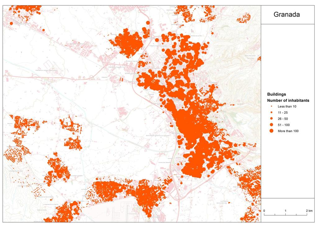
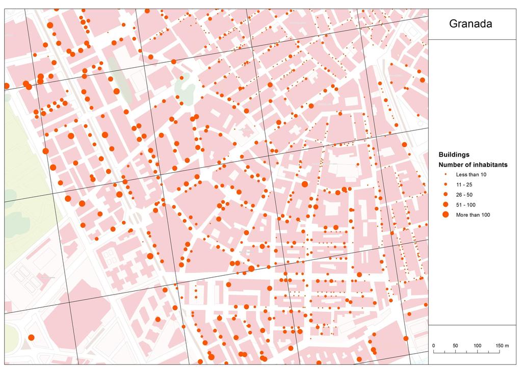
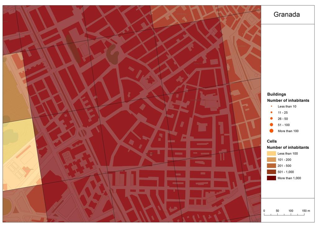
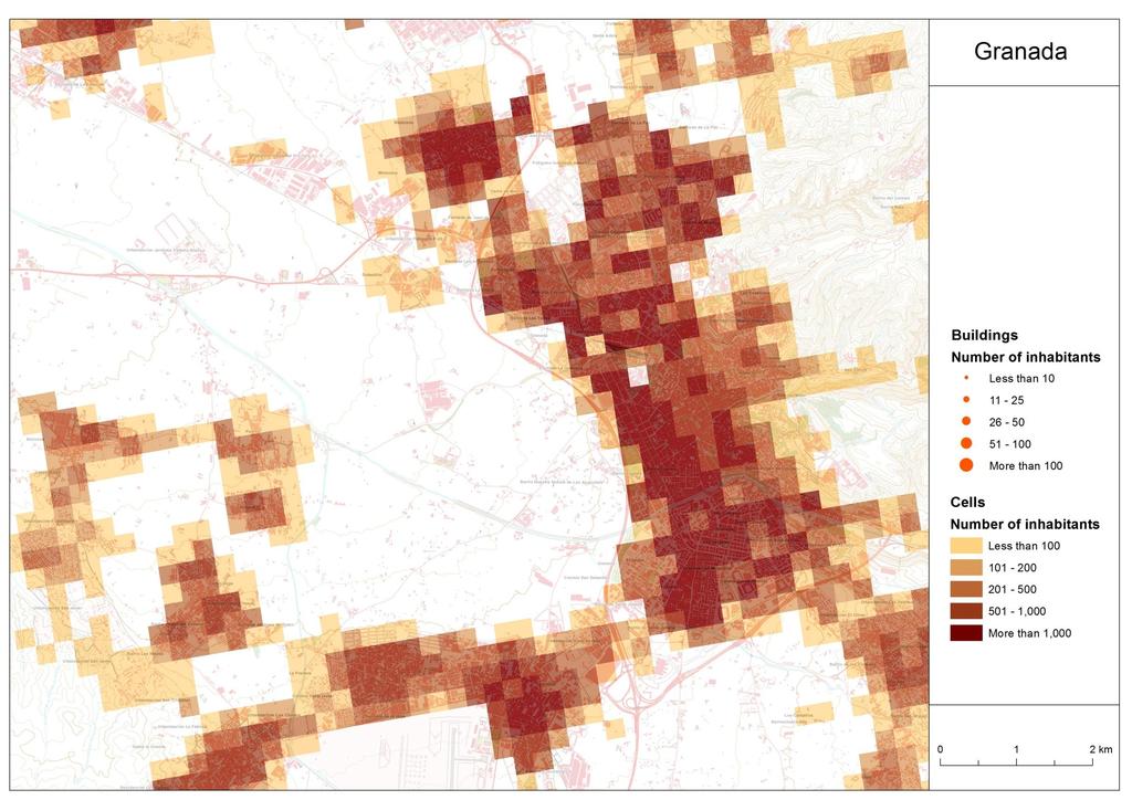
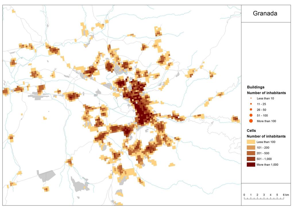
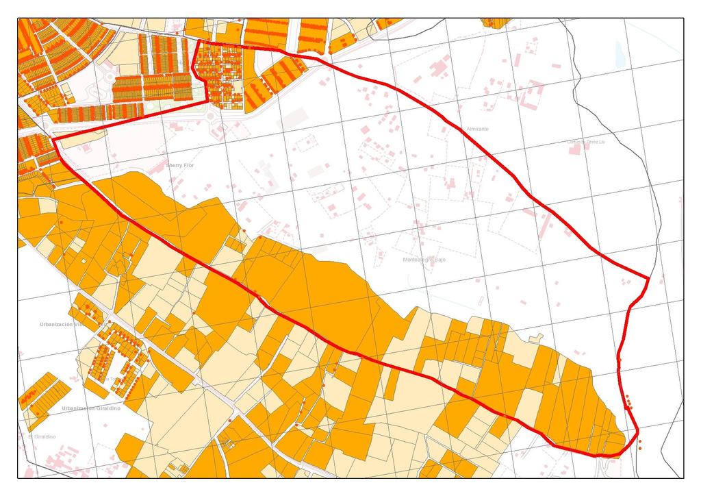
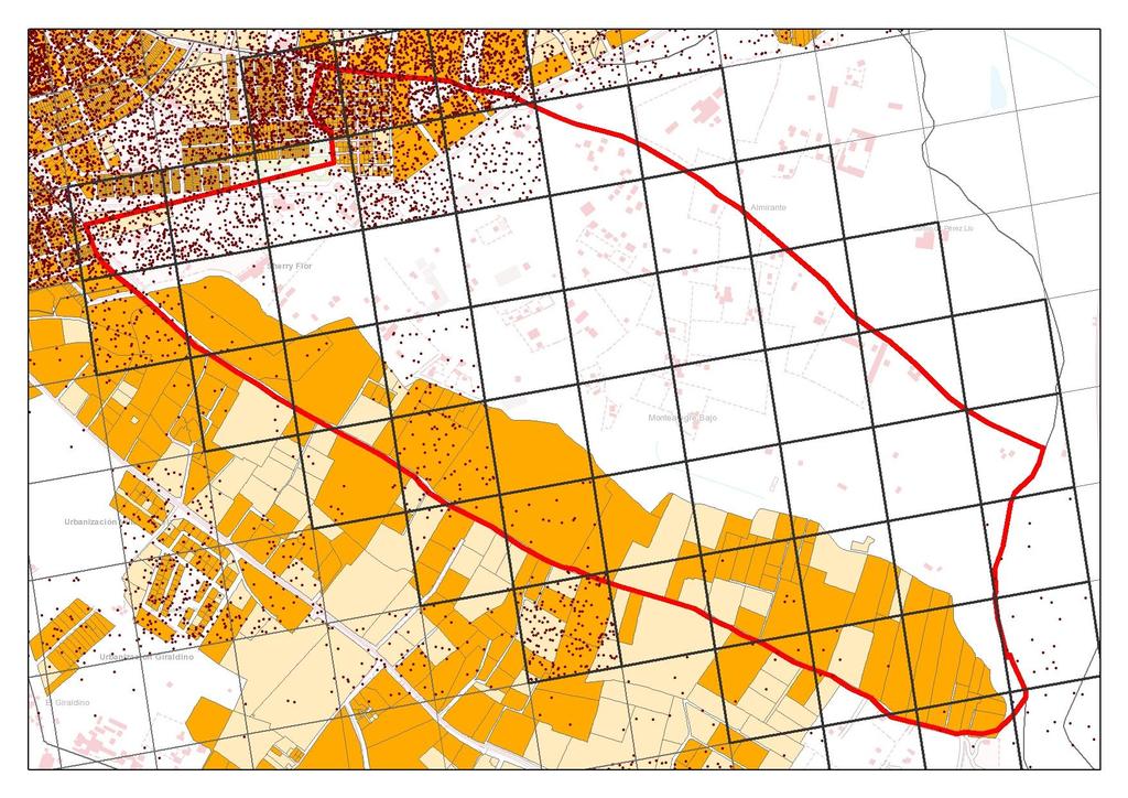
14 An example in the Metropolitan Area of Granada
15
16
17
18
19
20
21
22
23 IECA project. Population grid cells sized 250 x 250m for Andalusia 1. Highlights & main information sources 2. Georeferentiation of the population 2.1. Bottom-up approach: the geocoding of buildings main entrances 2.2. Top-down approach: the spatial disaggregation of non georeferenced households 2.3 Hybrid results 3. The dissemination of the results: visualization of the spatial distribution of the population in Andalusia
24 IECA project. Population grid cells sized 250 x 250m for Andalusia 1. Highlights & main information sources 2. Georeferentiation of the population 2.1. Bottom-up approach: the geocoding of buildings main entrances 2.2. Top-down approach: the spatial disaggregation of non georeferenced households 2.3 Hybrid results 3. The dissemination of the results: visualization of the spatial distribution of the population in Andalusia


25 2.2. Top-down approach: the spatial disaggregation of non georeferenced households Question People in non georeferenced households 87.4% Georeferenced Non georeferenced 68% of the censustracts have nongeoreferenced households 12.6% 12.6% of the population living in households could not be exactly georeferenced via bottom-up approach. Therefore a top-down approach was designed to allocate them spatially to a cell Census-tract level is the maximum territorial disaggregation available for non-georeferenced households Based on statistical techniques and ancillary information, the aim of the top-down approach is to transfer these data (non-georeferenced households) from the census-tracts zoning system to the grid zoning system
26 2.2. Top-down approach: the spatial disaggregation of non georeferenced households Alternatives To allocate spatially to a cell non georeferenced households from a census-tract Basic option: Assuming population distributes uniformly along the territory (choropleth) Alternative: Modelling settlement patterns for non georeferenced households based on ancilliary information. A descriptive analysis of georeferenced and non georeferenced households shows differences in settlement patterns and spatial correlation

27 2.2. Top-down approach: the spatial disaggregation of non georeferenced households Cartogram- Percentage of non-georeferenced households

28 2.2. Top-down approach: the spatial disaggregation of non georeferenced households
29 2.2. Top-down approach: the spatial disaggregation of non georeferenced households Information sources: Census-tracts layer (National Statistical Institute, Spain) And information processing census-tract/cells In order to transfer non-georeferenced households from the census-tracts zoning system to the grid zoning system a transferring spatial unit was defined: Census-tract/cells Census-tract/cells result from the intersection between the layer of census-tracts and the grid Census-tract/cells are the reference spatial unit for the analysis. The allocation model assigns population from census-tract to census-tract/cells Cells are built afterwards by adding all censustract/cells composing a cell

30 Census-tracts

31 Census-tract/cells
32 2.2. Top-down approach: the spatial disaggregation of non georeferenced households Information sources: - Urban Cadastre layer (Cadastre Unit, Ministry of Finance and Public Administration, Spain) And information processing census-tract/cell/parcels Cadastre territorial delimitation unit is parcel. In order to transfer parcel information to censustract/cell unit a transferring unit was defined: census-tract/cell/parcel Census-tract/cell/parcels result from the intersection between the parcel layer with the census-tract/cell layer Cadastre analysis focused on urban parcels layers containing usage information, residential as well as other usages (residential, commercial, recreational areas versus industrial or construction works areas)
33 Census-tract/cell/parcels
34 2.2. Top-down approach: the spatial disaggregation of non georeferenced households Information sources: - Urban Cadastre layer (Cadastre Unit, Ministry of Finance and Public Administration, Spain) And information processing Alphanumeric data Residential usage parcels are key to the project; hence information available in cadastre regarding their attributes & characteristics was explored in detailed Properties information: age, type of road where a property is located, etc. considered relevant as nongeoreferentiation is basically the result of a mismatching of a record linkage algorithm. Information referring to degree of urban consolidation (urban areas recently constructed, areas with high percentage of unusual types of roads, areas with high percentage of warehouses buildings, etc.) might shed light on the factors that hindered the linking process Properties information aggregated by parcel. i.e: all attributes for the properties inside a parcel were added or averaged, depending on the cases
35 2.2. Top-down approach: the spatial disaggregation of non georeferenced households Variables appearing highly correlated with non georeferentiation incidence Four regression models are built by non georeferentiation intensity group Population Register of Andalusia (RPA) Georeferenced households Georeferenced population by age Georeferenced population by nationality Georeferenced households and population in disseminated areas Urban Cadastre Real estate/immovable properties by type (industrial, residential ) Real estate/immovable properties by type of road where it is located (avenue, street, square, lane, etc.) Real estate/immovable properties year of construction Urban area and urban area containing residential real estate
36 2.2. Top-down approach: the spatial disaggregation of non georeferenced households Our proposal Iterative algorithm based on linear regressions modelled by non georeferentiation intensity group 1. Modeling non georeferenced households at census-tract level (administrative division) 2. Projection of non georeferenced households at census tract/cell level (dasymetric mapping) 3. Volume constraint, total non georeferenced households at census-tract level (pycnophylactic constraint) 4. Models re estimation at census tract/cell level and process iteration until convergence criteria is attained
37 IECA project. Population grid cells sized 250 x 250m for Andalusia 1. Highlights & main information sources 2. Georeferentiation of the population 2.1. Bottom-up approach: the geocoding of buildings main entrances 2.2. Top-down approach: the spatial disaggregation of non georeferenced households 2.3 Hybrid results 3. The dissemination of the results: visualization of the spatial distribution of the population in Andalusia
38 IECA project. Population grid cells sized 250 x 250m for Andalusia 1. Highlights & main information sources 2. Georeferentiation of the population 2.1. Bottom-up approach: the geocoding of buildings main entrances 2.2. Top-down approach: the spatial disaggregation of non georeferenced households 2.3 Hybrid results 3. The dissemination of the results: visualization of the spatial distribution of the population in Andalusia
39 2.3. Hybrid results The final step is to add to each cell the geo-referenced population in the bottom-up approach (geocoding of the buildings) and the population assigned in the top-down approach (allocated non geo-referenced households) The end result can be seen in the following maps:
40
41
42
43
")
44 Distribution of the population by cells (250 m) in Andalusia
45 IECA project. Population grid cells sized 250 x 250m for Andalusia 1. Highlights & main information sources 2. Georeferentiation of the population 2.1. Bottom-up approach: the geocoding of buildings main entrances 2.2. Top-down approach: the spatial disaggregation of non georeferenced households 2.3 Hybrid results 3. The dissemination of the results: visualization of the spatial distribution of the population in Andalusia
46 3. The dissemination of the results Visualization of the spatial distribution of the population in Andalusia
47 More information: Iria Enrique Serafín Ojeda
Georeferencing. Georeferencing: = linking a layer or dataset with spatial coordinates. Registration: = lining up layers with each other
 Georeferencing How do we make sure all our data layers line up? Georeferencing: = linking a layer or dataset with spatial coordinates Registration: = lining up layers with each other Rectification: The
How to Get Census Data from E-STAT
 How to Get Census Data from E-STAT Connecting to E-STAT 1) From the Library Home Page, http://library.mcmaster.ca, click on the Databases tab 2) Once on the Databases tab, type in estat and hit the Go
Review of Cartographic Data Types and Data Models
 Review of Cartographic Data Types and Data Models GIS Data Models Raster Versus Vector in GIS Analysis Fundamental element used to represent spatial features: Raster: pixel or grid cell. Vector: x,y coordinate
Developed as part of a research contract from EPA Region 9 Partnered with Dr. Paul English, CA DPH EHIB
 Air quality hazards defined by CalEPA/ CARB with recommendations for health protective buffer zones to separate these hazards from sensitive populations Developed as part of a research contract from EPA
Geocoding Reference USA data in ArcMap 9.3
 Tufts GIS Tip Sheet Geocoding Reference USA data in ArcMap 9.3 Written by Barbara Parmenter Revised 3/1/2011 In this exercise, you will map businesses or services for a town in the Boston metropolitan
The Address Point Data Standard for Minnesota Overview and Frequently Asked Questions
 The Address Point Data Standard for Minnesota Overview and Frequently Asked Questions Introduction. Address points are a core geospatial infrastructure dataset for Minnesota. They are a foundational data
NAACCR Geocoding Tutorial
 NAACCR Geocoding Tutorial Introduction The goal of the tutorial is to familiarize you with the NAACCR online geocoder. The NAACCR geocoder can be used to geocode one address at a time or in batch mode
GIS Basics for Urban Studies
 GIS Basics for Urban Studies Date: March 21, 2018 Contacts: Mehdi Aminipouri, Graduate Peer GIS Faciliator, SFU Library (maminipo@sfu.ca) Keshav Mukunda, GIS & Map Librarian Librarian for Geography (kmukunda@sfu.ca)
GEOGRAPHIC INFORMATION SYSTEMS Lecture 18: Spatial Modeling
 Spatial Analysis in GIS (cont d) GEOGRAPHIC INFORMATION SYSTEMS Lecture 18: Spatial Modeling - the basic types of analysis that can be accomplished with a GIS are outlined in The Esri Guide to GIS Analysis
Redistricting and Geographic Deployment at the Ottawa Police Service Esri Canada User Conference Ottawa October 12, 2017
 Redistricting and Geographic Deployment at the Ottawa Police Service Esri Canada User Conference Ottawa October 12, 2017 Introduction Alyson Yaraskovitch, B.A., M.A. Crime Intelligence Analyst Ottawa Police
Geodatabases. Dr. Zhang SPRING 2016 GISC /03/2016
 Geodatabases Dr. Zhang SPRING 2016 GISC 1401 10/03/2016 Using and making maps Navigating GIS maps Map design Working with spatial data Spatial data infrastructure Interactive maps Map Animations Map layouts
Using analytical tools in ArcGIS Online to determine where populations vulnerable to flooding and landslides exist in Boulder County, Colorado.
 Using analytical tools in ArcGIS Online to determine where populations vulnerable to flooding and landslides exist in Boulder County, Colorado. Estimated Time to complete: 1-2 hours Learning Objective:
Match and Location Codes
 Centrus GeoStan Match and Location Codes Version 28.00 For Windows, UNIX/Linux, z/os April 2015 2015 Pitney Bowes Software Inc. All rights reserved. Pitney Bowes Software Inc. is a wholly-owned subsidiary
Getting Started with GeoQuery
 Getting Started with GeoQuery A quick-start guide to the download and use of spatial data for international development geo.aiddata.org GeoQuery Quick Start Handbook v. 1.01, December 2017 WWW.GEOQUERY.ORG
SHRP2 C10: Jacksonville
 SHRP2 C10: Jacksonville Partnership to Develop an Integrated Advanced Travel Demand Model and a Fine grained Timesensitive Network Presented by: Stephen Lawe Key Agency Partners: Florida Department of
The Data Journalist Chapter 7 tutorial Geocoding in ArcGIS Desktop
 The Data Journalist Chapter 7 tutorial Geocoding in ArcGIS Desktop Summary: In many cases, online geocoding services are all you will need to convert addresses and other location data into geographic data.
HTC Data Use Tool - User s Manual
 HTC Data Use Tool - User s Manual Module 1: Inputting data into the HTC Data Use Tool Global Strategic Information UCSF Global Health Sciences http://globalhealthsciences.ucsf.edu/pphg/gsi Contact us:
The US Census Geographic Support System Initiative (GSS-I): Working with Partners for Enhanced Data Management KY GIS Conference, 10/01/13
: Working with Partners for Enhanced Data Management KY GIS Conference, 10/01/13") The US Census Geographic Support System Initiative (GSS-I): Working with Partners for Enhanced Data Management KY GIS Conference, 10/01/13 Kevin Holmes, Geographer US Census Bureau: Philadelphia Regional
The US Census Geographic Support System Initiative (GSS-I): Working with Partners for Enhanced Data Management KY GIS Conference, 10/01/13 Kevin Holmes, Geographer US Census Bureau: Philadelphia Regional
* George Washington University report: Counting for Dollars 2020: The Role of the Decennial Census in the Geographic Distribution of Federal Funds
 1 2 * George Washington University report: Counting for Dollars 2020: The Role of the Decennial Census in the Geographic Distribution of Federal Funds (https://gwipp.gwu.edu/counting dollars role decennial
Geocoding: The Basics
 Geocoding: The Basics Karyn Backus CT Dept of Public Health November 2012 ArcGIS 10 This guide is NOT an introduction to GIS or to geocoding. In order to use this guide, it is expected that you are familiar
Egyptian Survey Authority Geographic Information Management System (ESA GIM)
") Egyptian Survey Authority Geographic Information Management System (ESA GIM) Sohail El ABD and Kholoud SAAD, Egypt Key words: GIS, theme, etc. SUMMARY ESA can be regarded as the backbone for supplying
Egyptian Survey Authority Geographic Information Management System (ESA GIM) Sohail El ABD and Kholoud SAAD, Egypt Key words: GIS, theme, etc. SUMMARY ESA can be regarded as the backbone for supplying
DOWNTOWN INDUSTRIAL CORE Data and Recommendations
 DOWTOW IDUSTRIAL CORE Data and Recommendations SUMMARY DATA 620.4 Total Acres of Land 52% Light Industrial Use 0% Heavy Industrial use 2% Residential Use 29% Commercial Use 19% Other 5.393 Businesses 788
Overview of SAS/GIS Software
 3 CHAPTER 1 Overview of SAS/GIS Software Introduction to Geographic Information Systems 3 Features of SAS Software 4 Data in SAS/GIS Applications 5 Spatial Data 5 Spatial Data Layers 6 Spatial Data Coverages
Data Visualization Techniques with Google Earth
 Data Visualization Techniques with Google Earth E-Learning for the GIS Professional Any Time, Any Place! geospatialtraining.com Course Outline Module 1: Google Earth Pro Fundamentals Module 2: Adding Features
AUTOMATIC DIVISION OF CENSUS DISTRICT BASED ON CONSTRAINT DELAUNAY TRIANGULATION
 CO-041 AUTOMATIC DIVISION OF CENSUS DISTRICT BASED ON CONSTRAINT DELAUNAY TRIANGULATION LIU D., MA W., CHENG J. Chinese Academy of surveying and Mapping, BEIJING, CHINA ABSTRACT Division of census district
SimplyMap Canada Research Guide
 SimplyMap Canada Research Guide October 2016 Contents What is SimplyMap?... 1 What can I do with SimplyMap?... 1 Get Started Using SimplyMap... 1 Understanding the Geography of the Census... 1 SimplyMap
Georeferencing Tutorials and Recommended Practices
 March 21, 2008 Georeferencing Tutorials and Recommended Practices Topic Page Introduction 1 Preparing address data for georefernecing 1 Available address geocoders, pros and cons 1 Using Batchgeocode.com
PUBLIC WORKS. 1oo. DiEital Fee Schedules. Effective January 1, 2008
 PUBLIC WORKS Geographic Information Systems DiEital Fee Schedules Effective January 1, 2008 Date Advertised 12103/07 In (Publication) Daily Business Journal Public Hearing Date Approved as to form: David
Pre-Census Planning. Population Census Data Dissemination and Use. Department of Statistics, MALAYSIA
 Population Census 2000 Department of Statistics, MALAYSIA Seminar on Population Census Data Dissemination and Use 10 12 Nov. 2003 Pretoria, South Africa Malaysia 1 Data Dissemination and Use Pre-Census
May 2012 Oracle Spatial User Conference
 1 May 2012 Oracle Spatial User Conference May 23, 2012 Ronald Reagan Building and International Trade Center Washington, DC USA Michele Sacchi Bridge Consulting Program Manager Geomarketing Analysis A
ENGRG 59910: Introduction to GIS
 ENGRG 59910: Introduction to GIS Lecture 05: GIS and Databases Basics Acknowledgment: Michael Piasecki Where are we now? Basic geographic concepts Introduction to GIS, coordinate system, projection, datum
Broadband coverage in Europe in 2012:
 Broadband coverage in Europe in 2012: Guide for France Prepared by: Laura Kell Date: 27 November 2012 Version: 1.1 Point Topic Ltd 73 Farringdon Road London EC1M 3JQ, UK Tel. +44 (0) 20 3301 3303 Email
An Urban Planning Web Viewer based on AJAX *
 An Urban Planning Web Viewer based on AJAX * Miguel R. Luaces, David Trillo Pérez, J. Ignacio Lamas Fonte, Ana Cerdeira-Pena Database Laboratory, University of A Coruña, Campus de Elviña s/n. A Coruña,
Census-ACS Master Index Files
 Census-ACS Master Index Files Documentation and User s Guide VERSION 1.1 March 1, 2013 Created by Michael J. Greenwald, Ph.D., AICP With assistance from Jonathan Brooks, Texas A&M Transportation Institute
US Geo-Explorer User s Guide. Web:
 US Geo-Explorer User s Guide Web: http://usgeoexplorer.org Updated on October 26, 2016 TABLE OF CONTENTS Introduction... 3 1. System Interface... 5 2. Administrative Unit... 7 2.1 Region Selection... 7
Note: you must explicitly follow these instructions to avoid problems
 Exercise 4 Attribute Tables and Census Tract Mapping 30 Points Note: We recommend that you use the Firefox web browser when working with the Census Bureau web site. Objectives: Become familiar with census
Tip Sheet: Using the Selection Tools for Querying
 Tip Sheet: Using the Selection Tools for Querying Written by Barbara M. Parmenter, revised 10/2/2015 OVERVIEW OF SELECTION TOOLS... 1 TIPS FOR USING SELECT BY ATTRIBUTE... 3 TIPS FOR USING SELECT BY LOCATION...
An Introduction to Geographic Information Systems (GIS) using ArcGIS 9.2
 using ArcGIS 9.2") An Introduction to Geographic Information Systems (GIS) using ArcGIS 9.2 by Marcel Fortin, GIS and Map Librarian, University of Toronto Libraries, 2009 gis.maps@utoronto.ca http://www.library.utoronto.ca/maplib/
An Introduction to Geographic Information Systems (GIS) using ArcGIS 9.2 by Marcel Fortin, GIS and Map Librarian, University of Toronto Libraries, 2009 gis.maps@utoronto.ca http://www.library.utoronto.ca/maplib/
Comparison study of the prevalence of cell phone use while driving in the City of Victoria, British Columbia
 Final Report Comparison study of the prevalence of cell phone use while driving in the City of Victoria, British Columbia A final report on the research project surveying the number of drivers using a
Lecture 6: GIS Spatial Analysis. GE 118: INTRODUCTION TO GIS Engr. Meriam M. Santillan Caraga State University
 Lecture 6: GIS Spatial Analysis GE 118: INTRODUCTION TO GIS Engr. Meriam M. Santillan Caraga State University 1 Spatial Data It can be most simply defined as information that describes the distribution
UPDATING OF VECTOR DATABASES AT THE INSTITUT CARTOGRAFIC DE CATALUNYA
 ISPRS Archive Vol. XXXVIII, Part 4-8-2-W9, "Core Spatial Databases - Updating, Maintenance and Services - from Theory to Practice", Haifa, Israel, 2010 UPDATING OF VECTOR DATABASES AT THE INSTITUT CARTOGRAFIC
The Reykjavik GIS project
 The Reykjavik GIS project Jörgen Þormóðsson - Manager of LUKR Stefán Guðlaugsson - GIS-manager of Samsýn City of Reykjavik Department of Environment and Planning Division of Geodesy and Geoinformatics
NAACCR Webinar Exercises. May 6, 2010 Kevin Henry Francis Boscoe
 NAACCR Webinar Exercises May 6, 2010 Kevin Henry Francis Boscoe EXERCISE 1 Google Earth and Geocoding Individual Cases Part 1 Introduction to Google Earth 1 Open Google Earth Click Start Programs Google
Remote sensing techniques applied to seismic vulnerability assessment
 Remote sensing techniques applied to seismic vulnerability assessment JJ Arranz (josejuan.arranz@upm.es), Y. Torres (y.torres@upm.es), A. Haghi (a.haghi@alumnus.upm.es), J. Gaspar (jorge.gaspar@upm.es)
Quantitative Mapping Using Census Data
 MAP, DATA & GIS LIBRARY maplib@brocku.ca ArcGIS Pro Census Mapping Quantitative Mapping Using Census Data This tutorial includes all necessary steps to create a thematic map using numeric census tract
DOAG CONFERENCE Data Warehouse & Business Intelligence. November 22, 2012 NürnbergConvention Center Ost Nürnberg
 November 2012 DOAG CONFERENCE Data Warehouse & Business Intelligence November 22, 2012 NürnbergConvention Center Ost Nürnberg Michele Sacchi Bridge Consulting Program Manager Geomarketing Analysis A developed
From Non-Spatial Data to Spatial Data. Geocoding & Georeferencing in ArcGIS
 03-Geocoding & Georeferencing In Arcgis.Doc Page 1 of 10 From Non-Spatial Data to Spatial Data. Geocoding & Georeferencing in ArcGIS Objectives Upon completion of this tutorial, you should be able to perform
Working with demographic grids in QGIS
 Working with demographic grids in QGIS Anna Dmowska dmowska@amu.edu.pl April 2017 1. Introduction SocScape (Social Landscape) is a research project which provides open access to high resolution (30 m)
Using American FactFinder
 Using American FactFinder John DeWitt Lisa Neidert Project Manager Data Services Social Science Data Analysis Network Population Studies Center What is American FactFinder? http://factfinder.census.gov
Beyond The Vector Data Model - Part Two
 Beyond The Vector Data Model - Part Two Introduction Spatial Analyst Extension (Spatial Analysis) What is your question? Selecting a method of analysis Map Algebra Who is the audience? What is Spatial
Developing a Comprehensive Address Data Standard for the United States
 Developing a Comprehensive Address Data Standard for the United States Address Standard Working Group: Martha McCart Wells, GISP, Spatial Focus Inc., Chair Carl Anderson, Fulton County, Georgia, US, Co-chair
Sampling. Single and Multi-Mode Surveys. Address-Based Sampling
 Sampling for Single and Multi-Mode Surveys using Address-Based Sampling Colm O Muircheartaigh NORC at the University of Chicago and University of Chicago Harris School NSF Conference The Future of Survey
ENGRG Introduction to GIS
 ENGRG 59910 Introduction to GIS Michael Piasecki October 5, 2014 Lecture 05: GIS and Databases Basics Where are we now? Basic geographic concepts Introduction to GIS, coordinate system, projection, datum
Massachusetts Institute of Technology Department of Urban Studies and Planning
 Massachusetts Institute of Technology Department of Urban Studies and Planning 11.204: Planning, Communication, and Digital Media Fall 2004 Recitation 6: Using Access to Query Multiple Data Sets 1. What
Tutorial for mapping Census 2016 data in Qgis by census tracts
 Tutorial for mapping Census 2016 data in Qgis by census tracts Skills you will learn: How to join a Census 2016 map layer to a Census 2016 non-map layer, based on a common joining field shared by the two
BC OnLine. Site Registry User s Guide. Last Updated June 11, 2014
 BC OnLine Site Registry User s Guide Last Updated June 11, 2014 Copyright Copyright 2014 Province of British Columbia. All rights reserved. This user s guide is for users of the BC OnLine services who
TRAINING GUIDE. Data Quality Tools for GIS and Lucity Spatial
 TRAINING GUIDE Data Quality Tools for GIS and Lucity Spatial Data Quality Tools for GIS and Lucity Spatial In this session, we ll cover the tools that can be used to ensure your GIS data is clean in regards
Part 2: Build your own Map Tour with ArcGIS Online
 Part 2: Build your own Map Tour with ArcGIS Online Tutorial Overview In this tutorial, students will create and publish their own Map Tour application, a type of Story Map Web application, through ArcGIS
User s Manual. Version
 COPERT Street Level User s Manual Version 2.2.53 Contents Introduction... 3 Installing COPERT street level... 4 Main menu items... 5 Menu Project... 5 Project > Project > Create file... 5 Project > Project
From Cadastres to Urban Environments for 3D Geomarketing
 From Cadastres to Urban Environments for 3D Geomarketing Martin Hachet and Pascal Guitton Abstract-- This paper presents tools performing automatic generation of urban environments for 3D geomarketing.
Cooperative collaboration between Municipalities using public GIS
 Cooperative collaboration between Municipalities using public GIS Prof. M. AbdelAziz, Professor, Department of Urban Planning, Faculty of Engineering, Al-Azhar University, Cairo, Egypt, (email: m_azizh@yahoo.com).
STATEWIDE CENTERLINE INITIATIVE EDITED: MAY 17, 2013
 STATEWIDE CENTERLINE INITIATIVE EDITED: MAY 17, 2013 WHAT IS THE CENTERLINE INITIATIVE? The Centerline Initiative is a joint effort between the Minnesota Department of Transportation (MnDOT), Minnesota
West Virginia Site Locator and West Virginia Street Locator
 West Virginia Site Locator and West Virginia Street Locator West Virginia GIS Technical Center Final Report Prepared August 2009 Revised June 2010 Revised February 2014 West Virginia GIS Technical Center
The New American FactFinder N E W F U N C T I O N A L I T Y B U T S O M E Q U I R K S
 The New American FactFinder N E W F U N C T I O N A L I T Y B U T S O M E Q U I R K S Good Things Have to know less to find data Table manipulation available online Can now map any (single) variable Drawbacks
Parallel Method for Dasymetric Mapping. Sam Zhang
 Parallel Method for Dasymetric Mapping Sam Zhang Overview Dasymetric mapping is a commonlyapplied algorithm in GIS that can determine the population distribution in a high resolution level. It maps the
The Proposed Road Centerline Standard for Minnesota Overview and Frequently Asked Questions
 The Proposed Road Centerline Standard for Minnesota Overview and Frequently Asked Questions Introduction. Road Centerlines are a foundational geospatial dataset for Minnesota. They are a foundational data
GIS IN ECOLOGY: CREATING RESEARCH MAPS
 GIS IN ECOLOGY: CREATING RESEARCH MAPS Contents Introduction... 2 Elements of Cartography... 2 Course Data Sources... 3 Tasks... 3 Establishing the Map Document... 3 Laying Out the Map... 5 Exporting Your
Increasing the efficiency and sustainability by institutional cooperation: The example of the Addresses Database of Catalonia
 Increasing the efficiency and sustainability by institutional cooperation: The example of the Addresses Database of Catalonia Inma Menacho, Miquel Latorre, Anna Lleopart INSPIRE Conference 2016 Barcelona,
Working with International Census Data in GIS
 Working with International Census Data in GIS Updated February 23, 2015 Table of Contents SETTING UP... 1 DATA SOURCES... 1 TABULAR CENSUS DATA... 2 2001 Tabular Census Data... 5 GEOGRAPHIC DATA... 5 JOINING
INDEX. 1. Introduction to GVSig. 2. Data estructure. 3. Open Project and management. 4. Views gestion Add layer. 4.2.
 GVSIG: QUICK GUIDE INDEX 1. Introduction to GVSig 2. Data estructure 3. Open Project and management 4. Views gestion 4.1. Add layer 4.2. Edit Layers 4.2.1. Layer Visibility 4.2.2. Point, line or area
2045 DEMOGRAPHIC FORECAST SURFACE TRANSPORTATION TECHNICAL COMMITTEE APRIL 28, 2017
 2045 DEMOGRAPHIC FORECAST SURFACE TRANSPORTATION TECHNICAL COMMITTEE APRIL 28, 2017 BACKGROUND The demographic forecasts provide a common base for regional planning and resource allocations. The forecasts
Mapping Census data in QGIS
 Mapping Census data in QGIS Contents Contents 1. Introduction...3 1.1. Census data...3 1.2. Boundary data...3 1.3. Mapping software...3 2. Obtain your census data...4 Step 1: Geography...4 Step 2: Topics...5
Session 6 Population and Housing Censuses; Registers of Population, Dwelling, and Buildings Brunei, August 2017
 Mariet Tetty Nuryetty mariet@bps.go.id Session 6 Population and Housing Censuses; Registers of Population, Dwelling, and Buildings Brunei, 22-24 August 2017 1. Record Linkage 2. How to do it? As a rule
Collect Relevant Demographics
 I N T R O D U C T I O N Collect Relevant Demographics Here we will collect demographics at the local level! At this point you should have identified and mapped a prioritized brownfield site. We will now
Peoria County Front Desk Map Application
 Peoria County Front Desk Map Application Quick Guide, 2017 At a First Glance This guide will tell users all they need to know about the Peoria County Front Desk application which can be found on the Peoria
Topology at the US Census
 Topology at the US Census Daniel Abugov www.acquisinc acquisinc.com dabugov@acquisinc acquisinc.com US Census Requirement for a census is incorporated into the Constitution of the United States* Used for:
HEALTH ANALYSIS AND INFORMATION SYSTEMS (AIS) PAN AMERICAN HEALTH ORGANIZATION (PAHO) Geographic Information System in Epidemiology and Public Health
 PAN AMERICAN HEALTH ORGANIZATION (PAHO) Geographic Information System in Epidemiology and Public Health") HEALTH ANALYSIS AND INFORMATION SYSTEMS (AIS) PAN AMERICAN HEALTH ORGANIZATION (PAHO) Geographic Information System in Epidemiology and Public Health Version 1.26 March 2003 User s Manual HEALTH ANALYSIS
HEALTH ANALYSIS AND INFORMATION SYSTEMS (AIS) PAN AMERICAN HEALTH ORGANIZATION (PAHO) Geographic Information System in Epidemiology and Public Health Version 1.26 March 2003 User s Manual HEALTH ANALYSIS
Tips for a Good Meshing Experience
 Tips for a Good Meshing Experience Meshes are very powerful and flexible for modeling 2D overland flows in a complex urban environment. However, complex geometries can be frustrating for many modelers
Exercise 4.1. Create New Variables in a Shapefile. GIS Techniques for Monitoring and Evaluation of HIV/AIDS and Related Programs
 GIS Techniques for Monitoring and Evaluation of HIV/AIDS and Related Programs Exercise 4.1 Create New Variables in a Shapefile *This training was developed as part of a joint effort between MEASURE Evaluation
GEOGRAPHIC INFORMATION SYSTEMS Lecture 02: Feature Types and Data Models
 GEOGRAPHIC INFORMATION SYSTEMS Lecture 02: Feature Types and Data Models Feature Types and Data Models How Does a GIS Work? - a GIS operates on the premise that all of the features in the real world can
Converting census data into GIS data
 Converting census data into GIS data For those interested in analyzing Canadian demographics data, census data can be downloaded directly from ODESI or the Canadian Census Analyser. In order to use the
Creating a Smaller Data Set from a Larger Data Set Vector Data
 Creating a Smaller Data Set from a Larger Data Set Vector Data Written by Barbara Parmenter, revised by Carolyn Talmadge January 16, 2015 USING THE SELECTION METHOD QUICK METHOD BY CREATING A LAYER FILE...
Human mobility study: using mobile phone data for simulation and transportation research
 1 Human mobility study: using mobile phone data for simulation and transportation research FuturMob17 workshop, 5-7 th September 2017 Mariem Fekih, Orange Labs, Hasselt University Zbigniew Smoreda, Orange
August 2016 G-NAF. Data Release Report
 Product: Prepared: G-NAF Data Report Revision History Date Version Change Coordinator 1.0 Initial Version Anthony Hesling Disclaimer PSMA Australia believes this publication to be correct at the time of
The Repast Simulation/Modelling System for Geospatial Simulation. Andrew Crooks. CASA University College London 1-19 Torrington Place London
 The Repast Simulation/Modelling System for Geospatial Simulation Andrew Crooks CASA University College London 1-19 Torrington Place London http://www.casa.ucl.ac.uk http://www.gisagents.blogspot.com Introduction
GIS in the Social and Natural Sciences. Last Lecture. Today s Outline 5/14/2017. GEOG 4110/5100 Special Topics in Geography
 GEOG 4110/5100 Special Topics in Geography GIS in the Social and Natural Sciences Working with Vector Data in a GIS Last Lecture We talked about the main types of vector data models (CDS, TDS, TIN, Networks)
Quick Guide to American FactFinder
 Quick Guide to American FactFinder 1. Search Terms... 2 2. Finding Neighborhoods... 6 3. Downloading the Tables 13 4. Interpreting the Numbers... 18 Introduction The American FactFinder is a useful online
ArcGIS Online (AGOL) Quick Start Guide Fall 2018
 Quick Start Guide Fall 2018") ArcGIS Online (AGOL) Quick Start Guide Fall 2018 ArcGIS Online (AGOL) is a web mapping tool available to UC Merced faculty, students and staff. The Spatial Analysis and Research Center (SpARC) provides
ArcGIS Online (AGOL) Quick Start Guide Fall 2018 ArcGIS Online (AGOL) is a web mapping tool available to UC Merced faculty, students and staff. The Spatial Analysis and Research Center (SpARC) provides
Delivering On Canada s Broadband Commitment Presentation to OECD/WPIE Public Sector Broadband Procurement Workshop December 4, 2002
 Delivering On Canada s Broadband Commitment Presentation to OECD/WPIE Public Sector Broadband Procurement Workshop December 4, 2002 Canada Demand Aggregation in a Federal Structure 3 major levels of government
Dan Goldberg GIS Research Laboratory Department of Computer Science University of Southern California
 Presented to: Faculty of the Computer Science Department of the University of Southern California 04-01-2010 Dan Goldberg GIS Research Laboratory Department of Computer Science University of Southern California
Remote Sensing and GIS. GIS Spatial Overlay Analysis
 Subject Paper No and Title Module No and Title Module Tag Geology Remote Sensing and GIS GIS Spatial Overlay Analysis RS & GIS XXXI Principal Investigator Co-Principal Investigator Co-Principal Investigator
Administration of Geographical & Postal Coding. January 2007
 January 2007 5 6 Caspian Sea 1 8 4 3 9 Post Codes in Iran 7 Persian Gulf Oman Sea Outlines Post Code System Implemented activities 5 digits Post code System Implementing activities 10 digits Post code
User s Guide. Census GIS India. Developed For: Planners, Administrators, Policy Makers, Researchers at all Levels. Developed By:
 User s Guide Census GIS India Developed For: Planners, Administrators, Policy Makers, Researchers at all Levels. Developed By: Riddhi Management Services Pvt. Ltd. www.riddhi.org Geographic Information
Geographical Information Systems Institute. Center for Geographic Analysis, Harvard University
 Geographical Information Systems Institute Center for Geographic Analysis, Harvard University LAB EXERCISE 5: Queries, Joins: Spatial and Non-spatial 1.0 Getting Census data 1. Go to the American Factfinder
Streamlining Editing Workflows. Amber Bethell
 Streamlining Editing Workflows Amber Bethell Workflow for solving geographic problems Ask a question Create or acquire data Validate and update data Analyze data Create cartographic product Act upon knowledge
Locating unknown connection services during reading routes
 1 Locating unknown connection services during reading routes Introduction Canal de Isabel II was founded in 1851 to provide water to Madrid (capital of Spain). Now it provides water to 5.5 million people
Help Documentation. Copyright 2007 WebAssist.com Corporation All rights reserved.
 Help Documentation Copyright 2007 WebAssist.com Corporation All rights reserved. Using Pro Maps for Google This wizard adds a Pro Map for Google to your web page, allowing you to configure and specify
Development and Maintenance of a Critical Application Geodatabase For DOT Use.
 Development and Maintenance of a Critical Application Geodatabase For DOT. Executive Summary This paper presents a description of the development and maintenance of a state-level database used by the Louisiana
Copyright The McGraw-Hill Companies, Inc. Permission required for reproduction or display.
 Chapter 8. ATTRIBUTE DATA INPUT AND MANAGEMENT 8.1 Attribute Data in GIS 8.1.1 Type of Attribute Table 8.1.2 Database Management 8.1.3 Type of Attribute Data Box 8.1 Categorical and Numeric Data 8.2 The
Small area statistics on de jure and de facto populations
 Small area statistics on de jure and de facto populations - population census and operational data of mobile phone network Naoki Makita a, *, Masakazu Kimura a, Masayuki Terada b, Motonari Kobayashi b