Neusiedler See project
|
|
|
- Luke Bennett
- 5 years ago
- Views:
Transcription


1 Young Authors Paper Analysis of ALS data and products in the Neusiedler See project Maja Bitenc

2 Objectives Technology of ALS Project Neusiedler See. Analyse of DTM quality Analyse of intensity Conclusion Outline 2
3 Objectives Getting to know the ALS. Acquiring practical experiences. DTM Quality control of the project Neusiedler See (sigmadtm.exe). Analising the intensity measurements of the project Neusiedler See. 3


 o")
4 Basics of ALS ALS mission o Data acquisition o Laser light o Moving of the laser beam Postprocessing o 3D coordinates Computation of the results o Digital Terrain Model (DTM) o Digital Surface Model (DSM) Application 4


5 Project Neusiedler See-Seewinkel Seewinkel Project regions Objactives: renaturalization of the natural basisn Aim: modeling high resolution and accuratedtm fot hydrological analysis. 5

6 Data acquisition ALS mision Company: TopScan Fliing date: 24. and Area: ~ 250 km² Number of strips: 57 Number of points: 1,05 miljarde Density: 1,5 točke na m² Measurement sistem: ALTM 2050 Digital camera: Emerge DSS Terrestrial measurements Areas: 12 kontrolnih mest Measurement basis: GPS mreža Method: tachimetry Expected accuracy: ± 3 cm 6
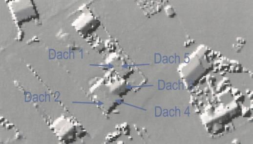
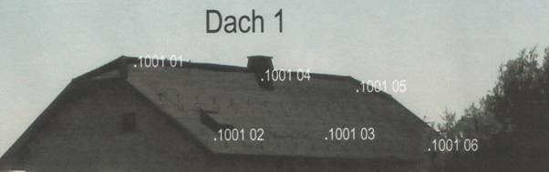
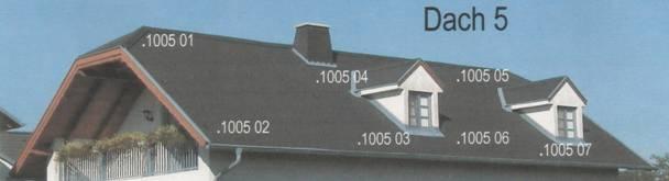
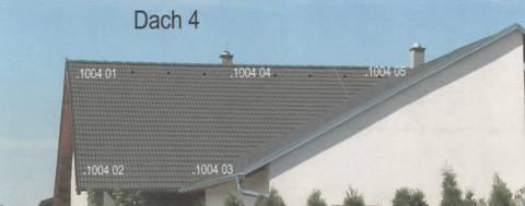
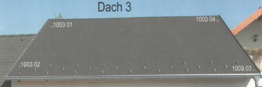

7 Terrestrial measurements Example: surveyed roofs in control area 10 7
8 Postprocessing Polar coordinates (R, α) Orientation Position Calibration data (dx, dy, dz, δω, δφ, δκ) Integration of DGPS and INS Orientation parameters (X o, Y o, Z o, ω, φ, κ ) GEOREFERENCING Time synchronization 3D point coordinates (X, Y, Z) WGS84 8
 FINE GEOREFERENCING Simultaneous block adjustment of strips Control points Control patches (terrestrial measurements) Adjusted 3D point coordinates (X, Y, Z)")
9 Skrbno georeferenciranje Polar coordinates (R, α) Orientation Position Calibration data (dx, dy, dz, δω, δφ, δκ) Tie points Tie patches (searching in the overlapping area) FINE GEOREFERENCING Simultaneous block adjustment of strips Control points Control patches (terrestrial measurements) Adjusted 3D point coordinates (X, Y, Z) WGS84 9

10 The DTM computation Iterative robust interpolation. Profile Weight function 10


11 Processing the measurements Digital terrain model calculation. Hierarchic iterative robust interpolation (SCOP++) 11
12 Global quality parameters σ z DTM quality control 6 [ cm] = ± + 30 tanα Where: n point density per square meter; tan(α) terrain slope; 6 in 30 experimentally computed parameters n Local quality parameters The method for the derivation of the height accuracy of each grid point. (sigmadtm.exe) o Used also for existing DTM. o independent of the interpolation method. o Grid resolution. o Attractive visualization (SCOP++). o Input data: original points, DTM. o Results: 5 digital models of quality parameters. 12

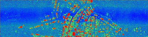

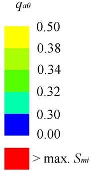


13 The local paramaters and visualization Minimum distance between each grid point and its nearest original point. Maximum main curvature. Height accuracy of original points σ0,d. Weight coefficient qa0. Height accuracy of the DTM σˆ DMR = σ 0.d q a 0 13

14 Comparison of local parameters 1/2 1. Schilf 2. Village 3. Vineyard 4. Field 5. Wood 14
15 Comparison of local parameters 2/2 1. Schilf 2. Village 3. Vineyard 4. Field 5. Wood 15

16 Intensity measurements analyze ALS measurements: polar coordinates, position, orientation, intensity. Influencing factors. o Laser scanner o atmosphere o target Definition; relation between emitted and received strength of laser wavelength. 16

17 Identical points Measured intensity: P ρ I m r P t = * konst. 2 R Intensity of identical points: I m1 = I m2 17
18 Normalization Δ I m = a * ΔR + b Relative normalization: 1. possibility : I 2 (2. strip is master) n I1 I1 = I m,1 + ΔI( ΔR) 2. possibility : I 1 (1. strip is master) n I 2 I 2 = I m,2 ΔI( ΔR) 18
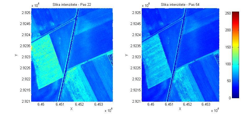

19 Normalization results 19

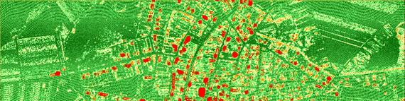
20 Classification Example: classification of green fields (meadows). 20
21 Conclusion DTM quality control o The DTM of Neusiedler See is very accurate. o The planimetric control of the DTM. o The calculation and the visualization of parameters is simple. o Data layers. Thank you for your Intensity measurement analyze attention! o Constant shift in measurements height of the flight. o Classification is not possible. Just lidar data do not suffice. o Potentially useful information about the surface. o Influencing factors. o Intensity dependency. o Different applications of intensity. 21
Processing of airborne laser scanning data
 GIS-E1020 From measurements to maps Lecture 8 Processing of airborne laser scanning data Petri Rönnholm Aalto University 1 Learning objectives To realize error sources of Airborne laser scanning To understand
Aalborg Universitet. Published in: Accuracy Publication date: Document Version Early version, also known as pre-print
 Aalborg Universitet A method for checking the planimetric accuracy of Digital Elevation Models derived by Airborne Laser Scanning Høhle, Joachim; Øster Pedersen, Christian Published in: Accuracy 2010 Publication
Hands-on practice: LIDAR data quality analysis and fine-georeferencing
 EUFAR - EUropean Facility for Airborne Research Hands-on practice: LIDAR data quality analysis and fine-georeferencing Christian Briese cb@ipf.tuwien.ac.at 1 Institute of Photogrammetry and Remote Sensing
Terrain Modeling and Mapping for Telecom Network Installation Using Scanning Technology. Maziana Muhamad
 Terrain Modeling and Mapping for Telecom Network Installation Using Scanning Technology Maziana Muhamad Summarising LiDAR (Airborne Laser Scanning) LiDAR is a reliable survey technique, capable of: acquiring
2010 LiDAR Project. GIS User Group Meeting June 30, 2010
 2010 LiDAR Project GIS User Group Meeting June 30, 2010 LiDAR = Light Detection and Ranging Technology that utilizes lasers to determine the distance to an object or surface Measures the time delay between
TerraMatch. Introduction
 TerraMatch Introduction Error sources Interior in LRF Why TerraMatch? Errors in laser distance measurement Scanning mirror errors Exterior in trajectories Errors in position (GPS) Errors in orientation
POSITIONING A PIXEL IN A COORDINATE SYSTEM
 GEOREFERENCING AND GEOCODING EARTH OBSERVATION IMAGES GABRIEL PARODI STUDY MATERIAL: PRINCIPLES OF REMOTE SENSING AN INTRODUCTORY TEXTBOOK CHAPTER 6 POSITIONING A PIXEL IN A COORDINATE SYSTEM The essential
CE 59700: LASER SCANNING
 Digital Photogrammetry Research Group Lyles School of Civil Engineering Purdue University, USA Webpage: http://purdue.edu/ce/ Email: ahabib@purdue.edu CE 59700: LASER SCANNING 1 Contact Information Instructor:
Airborne Laser Survey Systems: Technology and Applications
 Abstract Airborne Laser Survey Systems: Technology and Applications Guangping HE Lambda Tech International, Inc. 2323B Blue Mound RD., Waukesha, WI-53186, USA Email: he@lambdatech.com As mapping products
Laser scanners with echo digitization for full waveform analysis
 Laser scanners with echo digitization for full waveform analysis Peter Rieger, Andreas Ullrich, Rainer Reichert RIEGL Laser Measurement Systems GmbH DI Peter Rieger Project Management RIEGL LMS GmbH A-3580
ENY-C2005 Geoinformation in Environmental Modeling Lecture 4b: Laser scanning
 1 ENY-C2005 Geoinformation in Environmental Modeling Lecture 4b: Laser scanning Petri Rönnholm Aalto University 2 Learning objectives To recognize applications of laser scanning To understand principles
Trimble Geospatial Division Integrated Solutions for Geomatics professions. Volker Zirn Regional Sales Representative
 Trimble Geospatial Division Integrated Solutions for Geomatics professions Volker Zirn Regional Sales Representative 1 Agenda Trimble GeoSpatial Division Airborne System Solutions Trimble Inpho Software
COMPARATIVE ANALYSIS OF DIFFERENT LIDAR SYSTEM CALIBRATION TECHNIQUES
 COMPARATIVE ANALYSIS OF DIFFERENT LIDAR SYSTEM CALIBRATION TECHNIQUES M. Miller a, A. Habib a a Digitial Photogrammetry Research Group Lyles School of Civil Engineering Purdue University, 550 Stadium Mall
Post-mission Adjustment Methods of Airborne Laser Scanning Data
 Kris MORIN, USA and Dr. Naser EL-SHEIMY, Canada Key words: ALS, LIDAR, adjustment, calibration, laser scanner. ABSTRACT Airborne Laser Scanners (ALS) offer high speed, high accuracy and quick deployment
N.J.P.L.S. An Introduction to LiDAR Concepts and Applications
 N.J.P.L.S. An Introduction to LiDAR Concepts and Applications Presentation Outline LIDAR Data Capture Advantages of Lidar Technology Basics Intensity and Multiple Returns Lidar Accuracy Airborne Laser
Analysis of airborne laser scanning data and products in the Neusiedler See Project
 Analysis of airborne laser scanning data and products in the Neusiedler See Project Maja Bitenc * Abstract. The paper is a condensed presentation of the experimental part of my graduation project (Bitenc,
REGISTRATION OF AIRBORNE LASER DATA TO SURFACES GENERATED BY PHOTOGRAMMETRIC MEANS. Y. Postolov, A. Krupnik, K. McIntosh
 REGISTRATION OF AIRBORNE LASER DATA TO SURFACES GENERATED BY PHOTOGRAMMETRIC MEANS Y. Postolov, A. Krupnik, K. McIntosh Department of Civil Engineering, Technion Israel Institute of Technology, Haifa,
New Requirements for the Relief in the Topographic Databases of the Institut Cartogràfic de Catalunya
 New Requirements for the Relief in the Topographic Databases of the Institut Cartogràfic de Catalunya Blanca Baella, Maria Pla Institut Cartogràfic de Catalunya, Barcelona, Spain Abstract Since 1983 the
Performance Evaluation of Optech's ALTM 3100: Study on Geo-Referencing Accuracy
 Performance Evaluation of Optech's ALTM 3100: Study on Geo-Referencing Accuracy R. Valerie Ussyshkin, Brent Smith, Artur Fidera, Optech Incorporated BIOGRAPHIES Dr. R. Valerie Ussyshkin obtained a Ph.D.
Terrestrial GPS setup Fundamentals of Airborne LiDAR Systems, Collection and Calibration. JAMIE YOUNG Senior Manager LiDAR Solutions
 Terrestrial GPS setup Fundamentals of Airborne LiDAR Systems, Collection and Calibration JAMIE YOUNG Senior Manager LiDAR Solutions Topics Terrestrial GPS reference Planning and Collection Considerations
The Applanix Approach to GPS/INS Integration
 Lithopoulos 53 The Applanix Approach to GPS/INS Integration ERIK LITHOPOULOS, Markham ABSTRACT The Position and Orientation System for Direct Georeferencing (POS/DG) is an off-the-shelf integrated GPS/inertial
An Introduction to Lidar & Forestry May 2013
 An Introduction to Lidar & Forestry May 2013 Introduction to Lidar & Forestry Lidar technology Derivatives from point clouds Applied to forestry Publish & Share Futures Lidar Light Detection And Ranging
ifp Universität Stuttgart Performance of IGI AEROcontrol-IId GPS/Inertial System Final Report
 Universität Stuttgart Performance of IGI AEROcontrol-IId GPS/Inertial System Final Report Institute for Photogrammetry (ifp) University of Stuttgart ifp Geschwister-Scholl-Str. 24 D M. Cramer: Final report
Least Squares 3D surface matching
 Least Squares 3D surface matching Devrim Akca Institute of Geodesy and Photogrammetry Swiss Federal Institute of Technology Zurich www.photogrammetry.ethz.ch 1 The Objective: Co-registration of overlapping
Planimetric and height accuracy of airborne laserscanner data: User requirements and system performance
 Maas 117 Planimetric and height accuracy of airborne laserscanner data: User requirements and system performance HANS-GERD MAAS, Dresden University of Technology ABSTRACT Motivated by the primary use for
ICC experiences on Inertial / GPS sensor orientation. A. Baron, W.Kornus, J.Talaya Institut Cartogràfic de Catalunya, ICC
 ICC experiences on Inertial / GPS sensor orientation A. Baron, W.Kornus, J.Talaya Institut Cartogràfic de Catalunya, ICC Keywords: GPS/INS orientation, robustness Abstract In the last few years the photogrammetric
WADDENZEE SPRING SURVEY
 Report Lidar Survey WADDENZEE SPRING SURVEY 2016 Datum: 6th of June 2016 Client: Nederlandse Aardolie Maatschappij : Author: W. Velthoven Reviewer: F. de Boeck Project number: N605 Version: v1 page 1 van
AUTOMATIC IMAGE ORIENTATION BY USING GIS DATA
 AUTOMATIC IMAGE ORIENTATION BY USING GIS DATA Jeffrey J. SHAN Geomatics Engineering, School of Civil Engineering Purdue University IN 47907-1284, West Lafayette, U.S.A. jshan@ecn.purdue.edu Working Group
LIDAR MAPPING FACT SHEET
 1. LIDAR THEORY What is lidar? Lidar is an acronym for light detection and ranging. In the mapping industry, this term is used to describe an airborne laser profiling system that produces location and
POINT CLOUDS AND DERIVATIVES FOR NATIONWIDE GEOSPATIAL INFORMATION GEORGE VOSSELMAN
 POINT CLOUDS AND DERIVATIVES FOR NATIONWIDE GEOSPATIAL INFORMATION GEORGE VOSSELMAN OVERVIEW Point cloud generation and quality control New lidar technologies Dense matching Updating nationwide point clouds
Automatic DTM Extraction from Dense Raw LIDAR Data in Urban Areas
 Automatic DTM Extraction from Dense Raw LIDAR Data in Urban Areas Nizar ABO AKEL, Ofer ZILBERSTEIN and Yerach DOYTSHER, Israel Key words: LIDAR, DSM, urban areas, DTM extraction. SUMMARY Although LIDAR
Airborne Laser Scanning: Remote Sensing with LiDAR
 Airborne Laser Scanning: Remote Sensing with LiDAR ALS / LIDAR OUTLINE Laser remote sensing background Basic components of an ALS/LIDAR system Two distinct families of ALS systems Waveform Discrete Return
ALS40 Airborne Laser Scanner
 ALS40 Airborne Laser Scanner Airborne LIDAR for Professionals High Performance Laser Scanning Direct Measurement of Ground Surface from the Air The ALS40 Airborne Laser Scanner measures the topography
Tree height measurements and tree growth estimation in a mire environment using digital surface models
 Tree height measurements and tree growth estimation in a mire environment using digital surface models E. Baltsavias 1, A. Gruen 1, M. Küchler 2, P.Thee 2, L.T. Waser 2, L. Zhang 1 1 Institute of Geodesy
2. POINT CLOUD DATA PROCESSING
 Point Cloud Generation from suas-mounted iphone Imagery: Performance Analysis A. D. Ladai, J. Miller Towill, Inc., 2300 Clayton Road, Suite 1200, Concord, CA 94520-2176, USA - (andras.ladai, jeffrey.miller)@towill.com
Optimized Design of 3D Laser Triangulation Systems
 The Scan Principle of 3D Laser Triangulation Triangulation Geometry Example of Setup Z Y X Target as seen from the Camera Sensor Image of Laser Line The Scan Principle of 3D Laser Triangulation Detektion
Airborne Laser Scanning and Derivation of Digital Terrain Models 1
 Airborne Laser Scanning and Derivation of Digital Terrain Models 1 Christian Briese, Norbert Pfeifer Institute of Photogrammetry and Remote Sensing Vienna University of Technology Gußhausstraße 27-29,
Phone: (603) Fax: (603) Table of Contents
 Fax: (603) Table of Contents") Hydrologic and topographic controls on the distribution of organic carbon in forest Soils LIDAR Mapping Project Report Principal Investigator: Adam Finkelman Plumouth State University Plymouth State University,
Hydrologic and topographic controls on the distribution of organic carbon in forest Soils LIDAR Mapping Project Report Principal Investigator: Adam Finkelman Plumouth State University Plymouth State University,
FILTERING OF DIGITAL ELEVATION MODELS
 FILTERING OF DIGITAL ELEVATION MODELS Dr. Ing. Karsten Jacobsen Institute for Photogrammetry and Engineering Survey University of Hannover, Germany e-mail: jacobsen@ipi.uni-hannover.de Dr. Ing. Ricardo
Phone: Fax: Table of Contents
 Geomorphic Characterization of Precarious Rock Zones LIDAR Mapping Project Report Principal Investigator: David E. Haddad Arizona State University ASU School of Earth and Space
NATIONWIDE POINT CLOUDS AND 3D GEO- INFORMATION: CREATION AND MAINTENANCE GEORGE VOSSELMAN
 NATIONWIDE POINT CLOUDS AND 3D GEO- INFORMATION: CREATION AND MAINTENANCE GEORGE VOSSELMAN OVERVIEW National point clouds Airborne laser scanning in the Netherlands Quality control Developments in lidar
A QUALITY ASSESSMENT OF AIRBORNE LASER SCANNER DATA
 A QUALITY ASSESSMENT OF AIRBORNE LASER SCANNER DATA E. Ahokas, H. Kaartinen, J. Hyyppä Finnish Geodetic Institute, Geodeetinrinne 2, 243 Masala, Finland Eero.Ahokas@fgi.fi KEYWORDS: LIDAR, accuracy, quality,
AUTOMATIC BREAK LINE DETERMINATION FOR THE GENERATION OF A DTM ALONG THE RIVER MAIN
 AUTOMATIC BREAK LINE DETERMINATION FOR THE GENERATION OF A DTM ALONG THE RIVER MAIN Christian Briese ab, Gottfried Mandlburger ab, Camillo Ressl b and Herbert Brockmann c a Christian Doppler Laboratory
SimActive and PhaseOne Workflow case study. By François Riendeau and Dr. Yuri Raizman Revision 1.0
 SimActive and PhaseOne Workflow case study By François Riendeau and Dr. Yuri Raizman Revision 1.0 Contents 1. Introduction... 2 1.1. Simactive... 2 1.2. PhaseOne Industrial... 2 2. Testing Procedure...
Light Detection and Ranging (LiDAR)
") Light Detection and Ranging (LiDAR) http://code.google.com/creative/radiohead/ Types of aerial sensors passive active 1 Active sensors for mapping terrain Radar transmits microwaves in pulses determines
Light Detection and Ranging (LiDAR) http://code.google.com/creative/radiohead/ Types of aerial sensors passive active 1 Active sensors for mapping terrain Radar transmits microwaves in pulses determines
KEY WORDS: Laser altimetry, Error recovery, Strip adjustment, Segmentation
 Analysis and implementation of a laser strip adjustment model Sagi Filin Department of Geodesy, Faculty of Civil Engineering and Geosciences Delft University of Technology, The Netherlands s.filin@citg.tudelft.nl
A Hierarchical Quality-Dependent Approach Toward Establishing A Seamless Nationwide Topographic Database
 A Hierarchical Quality-Dependent Approach Toward Establishing A Seamless Nationwide Topographic Database Sagi Dalyot, Arieal Gershkovich, Yerach Doytsher Mapping and Geo-Inormation Engineering Technion,
LIDAR SYSTEM SELF-CALIBRATION USING PLANAR PATCHES FROM PHOTOGRAMMETRIC DATA
 LIDAR SSTEM SELF-CALIBRATION USING PLANAR PATCHES FROM PHOTOGRAMMETRIC DATA Ayman F. Habib a, *, Ki In Bang a, Sung-Woong Shin b, Edson Mitishita c a Department of Geomatics Engineering, University of
ANALYSIS AND ACCURACY ASSESSMENT OF AIRBORNE LASERSCANNING SYSTEM
 ANALYSIS AND ACCURACY ASSESSMENT OF AIRBORNE LASERSCANNING SYSTEM Abdullatif Alharthy¹, James Bethel², Edward M. Mikhail² ¹College of Engineering, Umm Al-Qura University, P.O. Box 555, Makkah, Saudi Arabia
Terrestrial Laser Scanning: Applications in Civil Engineering Pauline Miller
 Terrestrial Laser Scanning: Applications in Civil Engineering Pauline Miller School of Civil Engineering & Geosciences Newcastle University Overview Laser scanning overview Research applications geometric
Adrian Cosmin Ghimbaşan 1 Cornel Cristian Tereşneu 1 Iosif Vorovencii 1
 Adrian Cosmin Ghimbaşan 1 Cornel Cristian Tereşneu 1 Iosif Vorovencii 1 1 Forest Management Planning and Terrestrial Measurements Department, Faculty of Silviculture and Forest Engineering, Transilvania
LIDAR Workshop IPSRS Commission 1
 LIDAR Workshop IPSRS Commission 1 2-Jul-2007, Ljubliana, Slovenia Arthur Rohrbach, Leica Geosystems, Switzerland Presentation topics 1. Basics of Airborne LIDAR Sensing Technology 2. Typical Applications
Small-footprint full-waveform airborne LiDAR for habitat assessment in the ChangeHabitats2 project
 Small-footprint full-waveform airborne LiDAR for habitat assessment in the ChangeHabitats2 project Werner Mücke, András Zlinszky, Sharif Hasan, Martin Pfennigbauer, Hermann Heilmeier and Norbert Pfeifer
AUTOMATIC TARGET IDENTIFICATION FOR LASER SCANNERS
 AUTOMATIC TARGET IDENTIFICATION FOR LASER SCANNERS Valanis Α., Tsakiri Μ. National Technical University of Athens, School of Rural and Surveying Engineering, 9 Polytechniou Street, Zographos Campus, Athens
POINT CLOUD ANALYSIS FOR ROAD PAVEMENTS IN BAD CONDITIONS INTRODUCTION
 POINT CLOUD ANALYSIS FOR ROAD PAVEMENTS IN BAD CONDITIONS Yoshiyuki Yamamoto, Associate Professor Yasuhiro Shimizu, Doctoral Student Eiji Nakamura, Professor Masayuki Okugawa, Associate Professor Aichi
MATLAB and photogrammetric applications
 MALAB and photogrammetric applications Markéta Potůčková Department of applied geoinformatics and cartography Faculty of cience, Charles University in Prague Abstract Many automated processes in digital
LIDAR Data for Photogrammetric Georeferencing
 LIDAR Data for Photogrammetric Georeferencing Ayman HABIB, Mwafag GHANMA and Eui-Myoung KIM, Canada Key words: laser scanning, photogrammetry, triangulation, linear-features, absolute orientation, registration.
TERRESTRIAL LASER SCANNER DATA PROCESSING
 TERRESTRIAL LASER SCANNER DATA PROCESSING L. Bornaz (*), F. Rinaudo (*) (*) Politecnico di Torino - Dipartimento di Georisorse e Territorio C.so Duca degli Abruzzi, 24 10129 Torino Tel. +39.011.564.7687
Chapters 1 7: Overview
 Chapters 1 7: Overview Photogrammetric mapping: introduction, applications, and tools GNSS/INS-assisted photogrammetric and LiDAR mapping LiDAR mapping: principles, applications, mathematical model, and
1. LiDAR System Description and Specifications
 High Point Density LiDAR Survey of Mayapan, MX PI: Timothy S. Hare, Ph.D. Timothy S. Hare, Ph.D. Associate Professor of Anthropology Institute for Regional Analysis and Public Policy Morehead State University
INTEGRATION OF MOBILE LASER SCANNING DATA WITH UAV IMAGERY FOR VERY HIGH RESOLUTION 3D CITY MODELING
 INTEGRATION OF MOBILE LASER SCANNING DATA WITH UAV IMAGERY FOR VERY HIGH RESOLUTION 3D CITY MODELING Xianfeng Huang 1,2 Armin Gruen 1, Rongjun Qin 1 Tangwu Du 1, Wei Fang 1 1 Singapore-ETH Center, Future
HAWAII KAUAI Survey Report. LIDAR System Description and Specifications
 HAWAII KAUAI Survey Report LIDAR System Description and Specifications This survey used an Optech GEMINI Airborne Laser Terrain Mapper (ALTM) serial number 06SEN195 mounted in a twin-engine Navajo Piper
TLS Parameters, Workflows and Field Methods
 TLS Parameters, Workflows and Field Methods Marianne Okal, UNAVCO June 20 th, 2014 How a Lidar instrument works (Recap) Transmits laser signals and measures the reflected light to create 3D point clouds.
LiDAR for Urban Change Detection. Keith W. Cunningham, PhD Alaska Satellite Facility November 13, 2009
 LiDAR for Urban Change Detection Keith W. Cunningham, PhD Alaska Satellite Facility November 13, 2009 LiDAR LiDAR Light Detection and Ranging Building Footprints GIS outlines (planimetrics) GIS Geographic
Advanced Processing Techniques and Classification of Full-waveform Airborne Laser...
 f j y = f( x) = f ( x) n j= 1 j Advanced Processing Techniques and Classification of Full-waveform Airborne Laser... 89 A summary of the proposed methods is presented below: Stilla et al. propose a method
TLS Parameters, Workflows and Field Methods
 TLS Parameters, Workflows and Field Methods Marianne Okal, UNAVCO GSA, September 23 rd, 2016 How a Lidar instrument works (Recap) Transmits laser signals and measures the reflected light to create 3D point
Methods to survey, process, and georeference terrestrial LIDAR data to map regional seacliff erosion with uncertainty analysis
 Methods to survey, process, and georeference terrestrial LIDAR data to map regional seacliff erosion with uncertainty analysis Michael Olsen, Liz Johnstone, Adam Young, Scott Ashford, Neal Driscoll, and
Third Rock from the Sun
 Geodesy 101 AHD LiDAR Best Practice The Mystery of LiDAR Best Practice Glenn Jones SSSi GIS in the Coastal Environment Batemans Bay November 9, 2010 Light Detection and Ranging (LiDAR) Basic principles
Rigorous Scan Data Adjustment for kinematic LIDAR systems
 Rigorous Scan Data Adjustment for kinematic LIDAR systems Paul Swatschina Riegl Laser Measurement Systems ELMF Amsterdam, The Netherlands 13 November 2013 www.riegl.com Contents why kinematic scan data
LiDAR Data Processing:
 LiDAR Data Processing: Concepts and Methods for LEFI Production Gordon W. Frazer GWF LiDAR Analytics Outline of Presentation Data pre-processing Data quality checking and options for repair Data post-processing
CALIBRATION PROCEDURES OF THE IMAGING LASER ALTIMETER AND DATA PROCESSING
 CALIBRATION PROCEDURES OF THE IMAGING LASER ALTIMETER AND DATA PROCESSING Karl-Heinz Thiel, Aloysius Wehr Institut für Navigation, Universität Stuttgart Geschwister-Scholl-Str. 24D D-70174 Stuttgart KEYWORDS:
3D Point Cloud Processing
 3D Point Cloud Processing The image depicts how our robot Irma3D sees itself in a mirror. The laser looking into itself creates distortions as well as changes in intensity that give the robot a single
ANALYSIS OF FULL-WAVEFORM ALS DATA BY SIMULTANEOUSLY ACQUIRED TLS DATA: TOWARDS AN ADVANCED DTM GENERATION IN WOODED AREAS
 ANALYSIS OF FULL-WAVEFORM ALS DATA BY SIMULTANEOUSLY ACQUIRED TLS DATA: TOWARDS AN ADVANCED DTM GENERATION IN WOODED AREAS M. Doneus a,b *, C. Briese a,c, N. Studnicka d a Ludwig Boltzmann Institute for
Project Report Nooksack South Fork Lummi Indian Nation. Report Presented to:
 June 5, 2005 Project Report Nooksack South Fork Lummi Indian Nation Contract #2291-H Report Presented to: Lummi Indian Nation Natural Resources Department 2616 Kwina Road Bellingham, WA 98226 Point of
SENSOR FUSION: GENERATING 3D BY COMBINING AIRBORNE AND TRIPOD- MOUNTED LIDAR DATA
 International Archives of the Photogrammetry, Remote Sensing and Spatial Information Sciences, Vol. XXXIV-5/W10 SENSOR FUSION: GENERATING 3D BY COMBINING AIRBORNE AND TRIPOD- MOUNTED LIDAR DATA A. Iavarone
APPENDIX E2. Vernal Pool Watershed Mapping
 APPENDIX E2 Vernal Pool Watershed Mapping MEMORANDUM To: U.S. Fish and Wildlife Service From: Tyler Friesen, Dudek Subject: SSHCP Vernal Pool Watershed Analysis Using LIDAR Data Date: February 6, 2014
UTILIZACIÓN DE DATOS LIDAR Y SU INTEGRACIÓN CON SISTEMAS DE INFORMACIÓN GEOGRÁFICA
 UTILIZACIÓN DE DATOS LIDAR Y SU INTEGRACIÓN CON SISTEMAS DE INFORMACIÓN GEOGRÁFICA Aurelio Castro Cesar Piovanetti Geographic Mapping Technologies Corp. (GMT) Consultores en GIS info@gmtgis.com Geographic
Sensor Fusion: Generating 3D by Combining Airborne and Tripod mounted LIDAR Data
 Sensor Fusion: Generating 3D by Combining Airborne and Tripod mounted LIDAR Data Albert IAVARONE and Daina VAGNERS, Canada Key Words: LIDAR, Laser scanning, Remote sensing, Active sensors, 3D modeling,
Unwrapping of Urban Surface Models
 Unwrapping of Urban Surface Models Generation of virtual city models using laser altimetry and 2D GIS Abstract In this paper we present an approach for the geometric reconstruction of urban areas. It is
A New Protocol of CSI For The Royal Canadian Mounted Police
 A New Protocol of CSI For The Royal Canadian Mounted Police I. Introduction The Royal Canadian Mounted Police started using Unmanned Aerial Vehicles to help them with their work on collision and crime
Sensor Integration and Image Georeferencing for Airborne 3D Mapping Applications
 Sensor Integration and Image Georeferencing for Airborne 3D Mapping Applications By Sameh Nassar and Naser El-Sheimy University of Calgary, Canada Contents Background INS/GPS Integration & Direct Georeferencing
Surface and Terrain Models
 Advanced Matching Techniques for High Precision Surface and Terrain Models Introduction Comeback of image matching for DTM & DSM generation Very few professional tools for DSM generation from image matching
DIGITAL TERRAIN MODEL USING LASER SCANNING IN THE NEAPOLITAN VOLCANIC AREA. DAUR - University of Padua (2) DISTART - University of Bologna (3)
 DISTART - University of Bologna (3)") DIGITAL TERRAIN MODEL USING LASER SCANNING IN THE NEAPOLITAN VOLCANIC AREA Achilli V. (1), Al-Bayari O. (2), Borgström S. (3), Del Gaudio C. (3), De Martino P. (3), Dubbini M. (2), Fabris M. (1), Marzocchi
DIGITAL TERRAIN MODEL USING LASER SCANNING IN THE NEAPOLITAN VOLCANIC AREA Achilli V. (1), Al-Bayari O. (2), Borgström S. (3), Del Gaudio C. (3), De Martino P. (3), Dubbini M. (2), Fabris M. (1), Marzocchi
Automated Orientation of Aerial Images
 Automated Orientation of Aerial Images Joachim Höhle Aalborg University Denmark jh@i4.auc.dk Abstract Methods for automated orientation of aerial images are presented. They are based on the use of templates,
LiDAR & Orthophoto Data Report
 LiDAR & Orthophoto Data Report Tofino Flood Plain Mapping Data collected and prepared for: District of Tofino, BC 121 3 rd Street Tofino, BC V0R 2Z0 Eagle Mapping Ltd. #201 2071 Kingsway Ave Port Coquitlam,
Chapter 1: Overview. Photogrammetry: Introduction & Applications Photogrammetric tools:
 Chapter 1: Overview Photogrammetry: Introduction & Applications Photogrammetric tools: Rotation matrices Photogrammetric point positioning Photogrammetric bundle adjustment This chapter will cover the
DOCUMENTATION AND VISUALIZATION OF ANCIENT BURIAL MOUNDS BY HELICOPTER LASER SURVEYING
 DOCUMENTATION AND VISUALIZATION OF ANCIENT BURIAL MOUNDS BY HELICOPTER LASER SURVEYING Tsutomu Kakiuchi a *, Hirofumi Chikatsu b, Haruo Sato c a Aero Asahi Corporation, Development Management Division,
APPLICATION AND ACCURACY EVALUATION OF LEICA ADS40 FOR LARGE SCALE MAPPING
 APPLICATION AND ACCURACY EVALUATION OF LEICA ADS40 FOR LARGE SCALE MAPPING WenYuan Hu a, GengYin Yang b, Hui Yuan c,* a, b ShanXi Provincial Survey and Mapping Bureau, China - sxgcchy@public.ty.sx.cn c
Ground and Non-Ground Filtering for Airborne LIDAR Data
 Cloud Publications International Journal of Advanced Remote Sensing and GIS 2016, Volume 5, Issue 1, pp. 1500-1506 ISSN 2320-0243, Crossref: 10.23953/cloud.ijarsg.41 Research Article Open Access Ground
LiDAR data pre-processing for Ghanaian forests biomass estimation. Arbonaut, REDD+ Unit, Joensuu, Finland
 LiDAR data pre-processing for Ghanaian forests biomass estimation Arbonaut, REDD+ Unit, Joensuu, Finland Airborne Laser Scanning principle Objectives of the research Prepare the laser scanning data for
Integration of intensity information and echo distribution in the filtering process of LIDAR data in vegetated areas
 Integration of intensity information and echo distribution in the filtering process of LIDAR data in vegetated areas J. Goepfert, U. Soergel, A. Brzank Institute of Photogrammetry and GeoInformation, Leibniz
TLS Parameters, Workflows and Field Methods
 TLS Parameters, Workflows and Field Methods Marianne Okal, UNAVCO GSA, October 20 th, 2017 How a Lidar instrument works (Recap) Transmits laser signals and measures the reflected light to create 3D point
Marc Crombaghs, Sander Oude Elberink, Regine Brügelmann, Erik de Min
 $66(66,*+(,*+735(&,6,)/$6(5$/7,0(75
CLASSIFICATION OF NONPHOTOGRAPHIC REMOTE SENSORS
 CLASSIFICATION OF NONPHOTOGRAPHIC REMOTE SENSORS PASSIVE ACTIVE DIGITAL CAMERA THERMAL (e.g. TIMS) VIDEO CAMERA MULTI- SPECTRAL SCANNERS VISIBLE & NIR MICROWAVE HYPERSPECTRAL (e.g. AVIRIS) SLAR Real Aperture
SPOT-1 stereo images taken from different orbits with one month difference
 DSM Generation Almost all HR sensors are stereo capable. Some can produce even triplettes within the same strip (facilitating multi-image matching). Mostly SPOT (1-5) used for stereo and Ikonos (in spite
Comparison GRASS-LiDAR modules TerraScan with respect to vegetation filtering
 Comparison GRASS-LiDAR modules TerraScan with respect to vegetation filtering Sara Lucca sara.lucca@mail.polimi.it Maria Antonia Brovelli - maria.brovelli@polimi.it LiDAR system Detection system by a laser
Municipal Projects in Cambridge Using a LiDAR Dataset. NEURISA Day 2012 Sturbridge, MA
 Municipal Projects in Cambridge Using a LiDAR Dataset NEURISA Day 2012 Sturbridge, MA October 15, 2012 Jeff Amero, GIS Manager, City of Cambridge Presentation Overview Background on the LiDAR dataset Solar
THE USE OF ANISOTROPIC HEIGHT TEXTURE MEASURES FOR THE SEGMENTATION OF AIRBORNE LASER SCANNER DATA
 THE USE OF ANISOTROPIC HEIGHT TEXTURE MEASURES FOR THE SEGMENTATION OF AIRBORNE LASER SCANNER DATA Sander Oude Elberink* and Hans-Gerd Maas** *Faculty of Civil Engineering and Geosciences Department of
Photogrammetric Performance of an Ultra Light Weight Swinglet UAV
 Photogrammetric Performance of an Ultra Light Weight Swinglet UAV J. Vallet, F. Panissod, C. Strecha, M. Tracol UAV-g 2011 - Unmanned Aerial Vehicle in Geomatics September 14-16, 2011ETH Zurich Summary
Waddenzee LiDAR Survey September 2014
 Waddenzee LiDAR Survey September 2014 Final Report Datum: 2 February 2015 Client: Nederlandse Aardolie Maatschappij Author: Fugro Geospatial B.V. Project number: ASM11515.001 1. Introduction...2 2. Project