Intelligent photogrammetry. Agisoft
|
|
|
- Gordon Jacobs
- 5 years ago
- Views:
Transcription


1 Intelligent photogrammetry Agisoft

2 Agisoft Metashape is a cutting edge software solution, with its engine core driving photogrammetry to its ultimate limits, while the whole system is designed to deliver industry specific results relying on machine learning techniques for post-processing and analysis tasks. The software allows to process images from RGB or multispectral cameras, including multi-camera systems, into dense point clouds, textured polygonal models, georeferenced true orthomosaics and DSMs/DTMs. Further postprocessing enables to eliminate shadows and texture artifacts from the models, calculate vegetation indices and extract information for farming equipment action maps, automatically classify dense point clouds, etc.
.")
3 Very fast & highly accurate Based on the state-of-the-art technology developed by Agisoft, Metashape allows for very fast processing, providing at the same time highly accurate results both for aerial and close-range photography (up to 3cm for aerial, and up to 1mm for close-range photography). Local or cloud processing Agisoft Metashape is capable of processing of photos across a local cluster, thanks to distributed processing functionality. Alternatively, the project can be easily sent to the cloud to minimize hardware investment, with all the processing options being still available. Intuitive UI & stereo mode The software package has a linear project-based workflow that is intuitive and can be easily mastered even by a non-specialist, while professional photogrammetrists can benefit from advanced features like stereo mode and have complete control over the results accuracy, with detailed report being generated at the end of processing.


4 Enhanced photogrammetric engine with rigorous statistical assessment Photogrammetric engine inside Metashape software is developed to provide flexibility in the choice of the sensor, including support for frame, fish-eye and spherical cameras, as well as multi-camera systems, with new option to input slave offset reference to improve accuracy of the results. For processing of the data captured with consumer cameras, in addition to rolling shutter compensation, Metashape 1.5 was enhanced to work with photo-invariant parameters for higher precision in case of unstable interior orientation parameters. To perform uncertainty analysis of the results, covariance data is now available for all BBA parameters (camera IO and EO parameters, GPS/IMU antenna offset, slave sensor offset, tie points).
5

6 Classical photogrammetry with user-friendly interface Metashape enables to perform manual vectorization from stereo pairs using anaglyph glasses or specialized 3D displays for the tasks where it is necessary. Metashape 1.5 makes vectorization in stereo mode more convenient thanks to the possibility to directly select the stereo pair from the Photos pane, with the lock option to prevent from accidental switching. A new smart seamlines function automatically makes the seamlines bypass buildings and other objects to generate seamless orthomosaics based on DTMs.
7

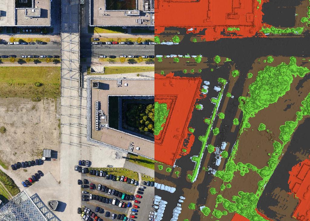
8 Modern post-processing tools for your applications Metashape is capable of eliminating shadows and texture artifacts from the models, calculating vegetation indices and extracting information for farming equipment action maps. With the new semantic classification of 3D point clouds, Metashape helps to solve the crucial task of higher-level interpretation of the scanned data. Using modern machine learning techniques Metashape 1.5 enables automatic dense point cloud classification into Ground, Vegetation, Building, Road and Car classes.
9

10 Local / Network processing / Cloud Metashape is optimized for multi-core CPUs and multi-gpu systems for fast generation of the results. Distributed processing on a HPC cluster helps to speed up all the calculations for massive data sets even further. Metashape 1.5 presents cloud processing option integrated in the application user interface for those who don t want to invest in the hardware infrastructure. Different payment plans are offered depending on the project demands.

11

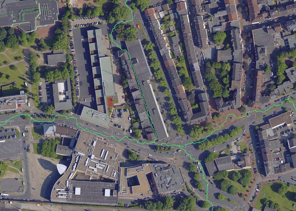
12 Seamless orthomosaic for Surveying & Mapping Metashape is a perfect tool for aerial imagery processing. The functionality of the program is being constantly developed according to the tasks set by rapidly emerging UAS industry. Metashape has proved to be a professional level post-processing tool capable of dense point clouds generation and classification for further exceptionally detailed DSMs/DTMs calculations and high-resolution seamless orthomosaics export, not to mention reconstruction of precise polygonal models of large scale objects. It is an indispensable part of GIS workflow starting with a UAV system.

13 Highly accurate measurements for Mining & Quarrying Highly accurate DEMs produced by Metashape lay the grounds for precise area and volume measurements, both for excavations and piles. Once multiple flights performed at different time moments, Metashape allows for volume change tracking, soil erosion and glacier studies. Automatic non-coded targets detection capability saves up on human work in inspection projects done on a regular basis

14 Customized vegetation index calculation for Precision Agriculture & Environmental Management With support for panchromatic, multispectral and thermal imagery, Metashape seamlessly integrates into workflows involving processing of data from diverse sources, like vegetation and soil analysis, fires and night studies, etc. Vegetation indices calculation according to a user-defined formula allows to analyze crop problems and generate prescriptions for variable rate farming equipment.

15 Consumer camera support for Archaeology & Documentation Archaeology more and more often relies on photogrammetric approaches today, be it a need to model an artifact or a demand for an excavation mapping. Thanks to the capability to process imagery from any digital camera, Metashape is widely used in various archaeological projects both up in the mountains and deep under the water, including special researches like a greenery pattern study to find ancient ruins under the ground or a rock art documentation and analysis project.

16 Oblique imagery support for Architecture & Cultural Heritage Preservation Numerous projects prove that Metashape is a quality tool to solve the tasks of facade and building modeling. With support for oblique imagery processing, Metashape allows to reconstruct the whole building, which can be employed for virtual tours creation, with reconstruction results being exhibited as illustrative models of largescale cultural heritage objects. 3D models of partially ruined monuments and artifacts generated with Metashape present reliable basis for restoration works thanks to exceptional accuracy of reconstruction results. Castle Spangenberg by Aibotix GmbH
17 Photorealistic textures for Visual Effects & Game Design Thanks to being highly detailed and photorealistic, Metashape models meet the strict requirements of professional animation studios, which successfully employ the software for movie and game production. Face and body capture results, being among the most demanded ones, prove that Metashape potential goes beyond one s imagination. Human scan by Infinite Realities
18 Advantages 01. Highly accurate and detailed results 02. Fully automated and intuitive workflow 03. GPU acceleration for faster processing 04. Network processing for large projects 05. Cloud processing to save up on infrastructure 06. Reasonably powerful Standard edition for art projects 07. Easy sharing with PDF / fly through video export and direct upload to online resources 08. Stereoscopic measurements for precise feature extraction Compatibility 01. Supports digital/film/video cameras and multi-camera systems 02. Processes images from frame/ fisheye/spherical/cylindrical cameras 03. Works well with most UAVs 04. Integrates with LIDAR workflows with point cloud import 05. Exports results in widely supported formats 06. Supports most EPSG coordinate systems and configurable vertical datums 07. Runs on Windows, Mac OS X and Linux
19 Capabilities 01. Aerial and close-range triangulation 02. Incremental image alignment 03. Dense point cloud generation and automatic classification 04. DSM/DTM generation 05. True orthomosaic generation in user defined projections 06. Automatic seamline refinement for traditional DTM-based orthomosaics 07. Manual seamline editing 08. Elevation contour lines generation 09. Georeferencing using flight log and/or GCPs 10. Coded and non-coded targets auto detection 11. Coordinate/distance/area/ volume measurements 12. Multispectral imagery processing and vegetation index calculation 13. Texture generation with delighting and deghosting filters 14. 4D reconstruction for dynamic scenes 15. Hierarchical tiled model generation and visualization 16. Polygonal model reconstruction 17. Spherical panorama stitching 18. Built-in Python scripting for job automation 19. Headless operation support
20 Want to try? Start your testing with free 30-day trial license available on request at Register at account.agisoft.com and get personal account to test cloud processing of your projects To place an order contact our sales department Benefit from the local purchase check the list of our authorized resellers at Agisoft LLC
PhotoScan. Fully automated professional photogrammetric kit
 PhotoScan Fully automated professional photogrammetric kit Agisoft PhotoScan is a stand-alone photogrammetric software solution for automatic generation of dense point clouds, textured polygonal models,
PhotoScan. Fully automated professional photogrammetric kit
 PhotoScan Fully automated professional photogrammetric kit Agisoft PhotoScan is a stand-alone photogrammetric software solution for automatic generation of dense point clouds, textured polygonal models,
Simply powerful. Pix4Dmapper features the raycloud. Read more on Next generation aerial image processing software
 Next generation aerial image processing software Simply powerful Pix4D is your solution to convert thousands of aerial images taken by lightweight UAV or aircraft into georeferenced 2D mosaics and 3D surface
Introduction. Acute3D S.A.S. WTC Valbonne Sophia Antipolis. 120 route des Macarons.
 Introduction This benchmark compares the performances of the three main photo-based 3Dmodeling software. Five projects related to different kind of applications were led on the same machine and this document
Feature Extraction from Imagery & Lidar. Kurt Schwoppe, Esri Mark Romero, Esri Gregory Bacon, Fairfax County
 Feature Extraction from & Lidar Kurt Schwoppe, Esri Mark Romero, Esri Gregory Bacon, Fairfax County Today s Speakers Image Processing Experts and Good Colleagues Kurt Schwoppe Industry Lead Esri Mark Romero
Surveying like never before
 CAD functionalities GCP Mapping and Aerial Image Processing Software for Land Surveying Specialists Surveying like never before www.3dsurvey.si Modri Planet d.o.o., Distributors: info@3dsurvey.si +386
What s New in Imagery in ArcGIS. Presented by: Christopher Patterson Date: October 18, 2017
 What s New in Imagery in ArcGIS Presented by: Christopher Patterson Date: October 18, 2017 Imagery in ArcGIS Advancing 2010 Stretch, Extract Bands Clip, Mask Reproject, Orthorectify, Pan Sharpen Vegetation
Drone2Map: an Introduction. October 2017
 Drone2Map: an Introduction October 2017 Drone2Map: An Introduction Topics: - Introduction to Drone Mapping - Coordinate Systems - Overview of Drone2Map - Basic Drone2Map Workflow - 2D Data Processing -
Quality Accuracy Professionalism
 GeoWing - who are we? Mapping Data Service Provider Lidar Multispectral Topographic and Planimetric Maps Elevation Models Point Clouds / 3D Models Orthophotography FAA-Authorized UAS Operators WOSB / DBE
Tutorial (Beginner level): Orthomosaic and DEM Generation with Agisoft PhotoScan Pro 1.3 (with Ground Control Points)
: Orthomosaic and DEM Generation with Agisoft PhotoScan Pro 1.3 (with Ground Control Points)") Tutorial (Beginner level): Orthomosaic and DEM Generation with Agisoft PhotoScan Pro 1.3 (with Ground Control Points) Overview Agisoft PhotoScan Professional allows to generate georeferenced dense point
Tutorial (Beginner level): Orthomosaic and DEM Generation with Agisoft PhotoScan Pro 1.3 (with Ground Control Points) Overview Agisoft PhotoScan Professional allows to generate georeferenced dense point
Tutorial (Beginner level): Orthomosaic and DEM Generation with Agisoft PhotoScan Pro 1.3 (without Ground Control Points)
: Orthomosaic and DEM Generation with Agisoft PhotoScan Pro 1.3 (without Ground Control Points)") Tutorial (Beginner level): Orthomosaic and DEM Generation with Agisoft PhotoScan Pro 1.3 (without Ground Control Points) Overview Agisoft PhotoScan Professional allows to generate georeferenced dense point
Tutorial (Beginner level): Orthomosaic and DEM Generation with Agisoft PhotoScan Pro 1.3 (without Ground Control Points) Overview Agisoft PhotoScan Professional allows to generate georeferenced dense point
UAV s in Surveying: Integration/processes/deliverables A-Z. 3Dsurvey.si
 UAV s in Surveying: Integration/processes/deliverables A-Z Info@eGPS.net TODAY S PROGRAM Introduction to photogrammetry and 3Dsurvey Theoretical facts about the technology and basics of 3dsurvey Introduction
EVOLUTION OF POINT CLOUD
 Figure 1: Left and right images of a stereo pair and the disparity map (right) showing the differences of each pixel in the right and left image. (source: https://stackoverflow.com/questions/17607312/difference-between-disparity-map-and-disparity-image-in-stereo-matching)
Photo based Terrain Data Acquisition & 3D Modeling
 Photo based Terrain Data Acquisition & 3D Modeling June 7, 2013 Howard Hahn Kansas State University Partial funding by: KSU Office of Research and Sponsored Programs Introduction: Need Application 1 Monitoring
Scalability for Large Photogrammetry Projects
 Scalability for Large Photogrammetry Projects Dr. Philippe Simard President SimActive Inc. IMAGE About SimActive Founded in 2003, SimActive is the developer of Correlator3D software, a patented end-to-end
Agisoft Metashape User Manual. Professional Edition, Version 1.5
 Agisoft Metashape User Manual Professional Edition, Version 5 Agisoft Metashape User Manual: Professional Edition, Version 5 Publication date 2018 Copyright 2018 Agisoft LLC Table of Contents Overview...
Open Pit Mines. Terrestrial LiDAR and UAV Aerial Triangulation for. Figure 1: ILRIS at work
 Terrestrial LiDAR and UAV Aerial Triangulation for Open Pit Mines Figure 1: ILRIS at work Figure 2: Geo-Copter X-8000 taking off ay what you will about the past few years, it has produced some useful tools
Agisoft Photogrammetric Kit User Manual. Professional Edition, Version 1.3
 Agisoft Photogrammetric Kit User Manual Professional Edition, Version 1.3 Agisoft Photogrammetric Kit User Manual: Professional Edition, Version 1.3 Publication date 2017 Copyright 2017 Agisoft LLC Table
Feel4U TerrEye. Tactical decision-support solutions for land management (for a better and cost-efficiency & environmental friendly land stewardship)
") Feel4U TerrEye Tactical decision-support solutions for land management (for a better and cost-efficiency & environmental friendly land stewardship) Guillaume Janssens Agro-Environment Consultant info@terreye.com
Feel4U TerrEye Tactical decision-support solutions for land management (for a better and cost-efficiency & environmental friendly land stewardship) Guillaume Janssens Agro-Environment Consultant info@terreye.com
2/9/2016. Session Agenda: Implementing new Geospatial Technologies for more efficient data capture
 Implementing new Geospatial Technologies for more efficient data capture Jay Haskamp Applied Geospatial Engineer Steve Richter VP Sales Session Agenda: Today s changing technologies and what lies ahead
UAS for Surveyors. An emerging technology for the Geospatial Industry. Ian Murgatroyd : Technical Sales Rep. Trimble
 UAS for Surveyors An emerging technology for the Geospatial Industry Ian Murgatroyd : Technical Sales Rep. Trimble Project Overview Voyager Quarry, located near Perth Australia Typical of hard rock mines,
The Use of UAS in modern field work
 The Use of UAS in modern field work SplitRS 2015, Thessaloniki, GREECE 22/05/2015 1 ebee by sensefly Swiss-made UAV Fully autonomous flight Suitable for: Mapping, GIS, Surveying Precision Agriculture Environmental
Photogrammetry for forest inventory.
 Photogrammetry for forest inventory. Marc Pierrot Deseilligny. IGN/ENSG, France. Jonathan Lisein. Ulg Gembloux Agro-Bio Tech, Belgium. 1- Photogrammetry 2- Application to forestry 3- Tools and proposed
Overview of the Trimble TX5 Laser Scanner
 Overview of the Trimble TX5 Laser Scanner Trimble TX5 Revolutionary and versatile scanning solution Compact / Lightweight Efficient Economical Ease of Use Small and Compact Smallest and most compact 3D
Agisoft PhotoScan User Manual. Professional Edition, Version 1.4
 Agisoft PhotoScan User Manual Professional Edition, Version 1.4 Agisoft PhotoScan User Manual: Professional Edition, Version 1.4 Publication date 2018 Copyright 2018 Agisoft LLC Table of Contents Overview...
LiForest Software White paper. TRGS, 3070 M St., Merced, 93610, Phone , LiForest
 0 LiForest LiForest is a platform to manipulate large LiDAR point clouds and extract useful information specifically for forest applications. It integrates a variety of advanced LiDAR processing algorithms
ERDAS IMAGINE THE WORLD S MOST WIDELY-USED REMOTE SENSING SOFTWARE PACKAGE
 PRODUCT BROCHURE ERDAS IMAGINE THE WORLD S MOST WIDELY-USED REMOTE SENSING SOFTWARE PACKAGE 1 ERDAS IMAGINE The world s most widely-used remote sensing software package 2 ERDAS IMAGINE The world s most
Agisoft PhotoScan User Manual. Professional Edition, Version 1.2
 Agisoft PhotoScan User Manual Professional Edition, Version 1.2 Agisoft PhotoScan User Manual: Professional Edition, Version 1.2 Publication date 2016 Copyright 2016 Agisoft LLC Table of Contents Overview...
Producing Ortho Imagery In ArcGIS. Hong Xu, Mingzhen Chen, Ringu Nalankal
 Producing Ortho Imagery In ArcGIS Hong Xu, Mingzhen Chen, Ringu Nalankal Agenda Ortho imagery in GIS ArcGIS ortho mapping solution Workflows - Satellite imagery - Digital aerial imagery - Scanned imagery
CREATING CUSTOMIZED SPATIAL MODELS WITH POINT CLOUDS USING SPATIAL MODELER OPERATORS TO PROCESS POINT CLOUDS IN IMAGINE 2014
 CREATING CUSTOMIZED SPATIAL MODELS WITH POINT CLOUDS USING SPATIAL MODELER OPERATORS TO PROCESS POINT CLOUDS IN IMAGINE 2014 White Paper December 22, 2016 Contents 1. Introduction... 3 2. ERDAS IMAGINE
Case Study for Long- Range Beyond Visual Line of Sight Project. March 15, 2018 RMEL Transmission and Planning Conference
 Case Study for Long- Range Beyond Visual Line of Sight Project March 15, 2018 RMEL Transmission and Planning Conference 2014 HDR Architecture, 2016 2014 HDR, Inc., all all rights reserved. Helicopters
PRODUCT BROCHURE IMAGESTATION HIGH VOLUME PHOTOGRAMMETRY AND PRODUCTION MAPPING
 PRODUCT BROCHURE IMAGESTATION HIGH VOLUME PHOTOGRAMMETRY AND PRODUCTION MAPPING UNPARALLELED PROCESSING, ACCURATE RESULTS FOR CAD AND GIS-BASED WORKFLOWS The ImageStation software suite enables digital
3D recording of archaeological excavation
 5 th International Conference Remote Sensing in Archaeology The Age of Sensing 13-15 October 2014 - Duke University 3D recording of archaeological excavation Stefano Campana UNIVERSITY of CAMBRIDGE Faculty
SimActive and PhaseOne Workflow case study. By François Riendeau and Dr. Yuri Raizman Revision 1.0
 SimActive and PhaseOne Workflow case study By François Riendeau and Dr. Yuri Raizman Revision 1.0 Contents 1. Introduction... 2 1.1. Simactive... 2 1.2. PhaseOne Industrial... 2 2. Testing Procedure...
Tutorial (Intermediate level): Dense Cloud Classification and DTM generation with Agisoft PhotoScan Pro 1.1
: Dense Cloud Classification and DTM generation with Agisoft PhotoScan Pro 1.1") Tutorial (Intermediate level): Dense Cloud Classification and DTM generation with Agisoft PhotoScan Pro 1.1 This tutorial illustrates how to perform dense point cloud classification in manual and automatic
Tutorial (Intermediate level): Dense Cloud Classification and DTM generation with Agisoft PhotoScan Pro 1.1 This tutorial illustrates how to perform dense point cloud classification in manual and automatic
Practical Considerations of UAS Operations on Data Quality
 Practical Considerations of UAS Operations on Data Quality Precision. Accuracy. Reliability OVERVIEW Project Planning and Execution Ground Control Data Processing and Delivery 1 OVERVIEW Get Legal: Section
Mosaicking Software: A comparison of various software suites. Geosystems Research Institute Report 5071
 Mosaicking Software: A comparison of various software suites Geosystems Research Institute Report 5071 Lee Hathcock (Mississippi State University) Ryan MacNeille (Altavian, Inc.) 3-24-2016 Mosaicking software
TRIMBLE BUSINESS CENTER PHOTOGRAMMETRY MODULE
 TRIMBLE BUSINESS CENTER PHOTOGRAMMETRY MODULE WHITE PAPER TRIMBLE GEOSPATIAL DIVISION WESTMINSTER, COLORADO, USA July 2013 ABSTRACT The newly released Trimble Business Center Photogrammetry Module is compatible
Coastal Survey of archaeological sites using drones
 Coastal Survey of archaeological sites using drones In Poseidon s Realm XXI Underwater archaeology - interdisciplinary approaches and technical innovations Dimitrios Skarlatos, Savvidou Eleni Photogrammetric
TRAINING MATERIAL HOW TO OPTIMIZE ACCURACY WITH CORRELATOR3D
 TRAINING MATERIAL WITH CORRELATOR3D Page2 Contents 1. UNDERSTANDING INPUT DATA REQUIREMENTS... 4 1.1 What is Aerial Triangulation?... 4 1.2 Recommended Flight Configuration... 4 1.3 Data Requirements for
1. Introduction. A CASE STUDY Dense Image Matching Using Oblique Imagery Towards All-in- One Photogrammetry
 Submitted to GIM International FEATURE A CASE STUDY Dense Image Matching Using Oblique Imagery Towards All-in- One Photogrammetry Dieter Fritsch 1, Jens Kremer 2, Albrecht Grimm 2, Mathias Rothermel 1
New! Analysis Ready Data Tools Add-on package for image preprocessing for multi-temporal analysis. Example of satellite imagery time series of Canada
 Highlights New! Analysis Ready Data Tools Add-on package for image preprocessing for multi-temporal analysis Rigorous scientific preprocessing Example of satellite imagery time series of Canada A new industry
ADVANCING REALITY MODELING WITH CONTEXTCAPTURE
 ADVANCING REALITY MODELING WITH CONTEXTCAPTURE Knowing the existing conditions of a project is a key asset in any decision process. Governments need to better know their territories, through mapping operations,
ROAD-SCANNER COMPACT APPLICATION FIELDS MAIN FEATURES
 ROAD-SCANNER COMPACT Mobile Mapping System by GEXCEL & SITECO collaboration A smaller mobile system for asset management and cartography suited for ZOLLER & FRÖHLICH PROFILER 9012 laser scanner. 2 + 3
a Geo-Odyssey of UAS LiDAR Mapping Henno Morkel UAS Segment Specialist DroneCon 17 May 2018
 a Geo-Odyssey of UAS LiDAR Mapping Henno Morkel UAS Segment Specialist DroneCon 17 May 2018 Abbreviations UAS Unmanned Aerial Systems LiDAR Light Detection and Ranging UAV Unmanned Aerial Vehicle RTK Real-time
Sasanka Madawalagama Geoinformatics Center Asian Institute of Technology Thailand
 Sasanka Madawalagama Geoinformatics Center Asian Institute of Technology Thailand This learning material was not prepared by ADB. The views expressed in this document are the views of the author/s and
Merging LiDAR Data with Softcopy Photogrammetry Data
 Merging LiDAR Data with Softcopy Photogrammetry Data Cindy McCallum WisDOT\Bureau of Technical Services Surveying & Mapping Section Photogrammetry Unit Overview Terms and processes Why use data from LiDAR
LIDAR MAPPING FACT SHEET
 1. LIDAR THEORY What is lidar? Lidar is an acronym for light detection and ranging. In the mapping industry, this term is used to describe an airborne laser profiling system that produces location and
WelcometotheJungle ofdigitalimagehandlingplatforms anddataproperties
 WelcometotheJungle ofdigitalimagehandlingplatforms anddataproperties A general overview with room for discussion and lots of questions By, Jesper Cairo Westergaard, Research IT Coordinator, University
Assessing the Accuracy of Stockpile Volumes Obtained Through Aerial Surveying
 CASE STUDY Assessing the Accuracy of Stockpile Volumes Obtained Through Aerial Surveying Martin Remote Sensing share surveying insight DroneDeploy Introduction This report comes to us from Kelsey Martin,
COMPONENTS. The web interface includes user administration tools, which allow companies to efficiently distribute data to internal or external users.
 COMPONENTS LASERDATA LIS is a software suite for LiDAR data (TLS / MLS / ALS) management and analysis. The software is built on top of a GIS and supports both point and raster data. The following software
Presented at the FIG Congress 2018, May 6-11, 2018 in Istanbul, Turkey
 Presented at the FIG Congress 2018, May 6-11, 2018 in Istanbul, Turkey Evangelos MALTEZOS, Charalabos IOANNIDIS, Anastasios DOULAMIS and Nikolaos DOULAMIS Laboratory of Photogrammetry, School of Rural
ERDAS IMAGINE THE WORLD S MOST WIDELY-USED REMOTE SENSING SOFTWARE PACKAGE
 PRODUCT BROCHURE ERDAS IMAGINE THE WORLD S MOST WIDELY-USED REMOTE SENSING SOFTWARE PACKAGE 1 ERDAS IMAGINE The world s most widely-used remote sensing software package 2 ERDAS IMAGINE The Theworld s world
IMAGERY FOR ARCGIS. Manage and Understand Your Imagery. Credit: Image courtesy of DigitalGlobe
 IMAGERY FOR ARCGIS Manage and Understand Your Imagery Credit: Image courtesy of DigitalGlobe 2 ARCGIS IS AN IMAGERY PLATFORM Empowering you to make informed decisions from imagery and remotely sensed data
IMAGINE EXPANSION PACK Extend the Power of ERDAS IMAGINE
 IMAGINE EXPANSION PACK Extend the Power of ERDAS IMAGINE IMAGINE EXPANSION PACK IMAGINE Expansion Pack is a collection of functionality to extend the utility of ERDAS IMAGINE. It includes 3D visualization
Unmanned Aerial Systems: A Look Into UAS at ODOT
 Ohio Department of Transportation John R. Kasich, Governor Jerry Wray, Director Unmanned Aerial Systems: Tim Burkholder, PS Mapping Manager Division of Engineering Office of CADD and Mapping Services Kyle
Slide 1. Bentley Descartes V8i. Presented by: Inga Morozoff, Bentley
 Slide 1 Bentley Descartes V8i Presented by: Inga Morozoff, Bentley Slide 2 Agenda What is Bentley Descartes? Where is it used? Features Benefits Live demo Questions and Answers 2 WWW.BENTLEY.COM Slide
IMAGINE Objective. The Future of Feature Extraction, Update & Change Mapping
 IMAGINE ive The Future of Feature Extraction, Update & Change Mapping IMAGINE ive provides object based multi-scale image classification and feature extraction capabilities to reliably build and maintain
Processing to Create a 3D Model
 3D Modelling Processing to Create a 3D Model These guidance notes take you through how to process multiple photographs of a rock art panel to create a 3D model. In order to do this, you first need to capture
Getting Started with Pix4D for Agriculture 3.3
 Getting Started with Pix4D for Agriculture 3.3 Sign-up 3 Redeem 4 Hardware - Computer 4 Software Download and Installation 5 Download 5 Installation 5 Update 8 Hardware - Cameras 8 Inputs 9 Outputs 9 Image
REMOTE SENSING LiDAR & PHOTOGRAMMETRY 19 May 2017
 REMOTE SENSING LiDAR & PHOTOGRAMMETRY 19 May 2017 SERVICES Visual Inspections Digital Terrain Models Aerial Imagery Volume Computations Thermal Inspections Photo maps Aerial Video Training & Consultancy
The Feature Analyst Extension for ERDAS IMAGINE
 The Feature Analyst Extension for ERDAS IMAGINE Automated Feature Extraction Software for GIS Database Maintenance We put the information in GIS SM A Visual Learning Systems, Inc. White Paper September
High resolution survey and orthophoto project of the Dosso-Gaya region in the Republic of Niger. by Tim Leary, Woolpert Inc.
 High resolution survey and orthophoto project of the Dosso-Gaya region in the Republic of Niger by Tim Leary, Woolpert Inc. Geospatial Solutions Photogrammetry & Remote Sensing LiDAR Professional Surveying
FOUR-BAND THERMAL MOSAICKING: A NEW METHOD TO PROCESS THERMAL IMAGERY FROM UAV FLIGHT YICHEN YANG YALE SCHOOL OF FORESTRY AND ENVIRONMENTAL STUDIES
 FOUR-BAND THERMAL MOSAICKING: A NEW METHOD TO PROCESS THERMAL IMAGERY FROM UAV FLIGHT YICHEN YANG YALE SCHOOL OF FORESTRY AND ENVIRONMENTAL STUDIES OUTLINE Background Objectives Methodology Results Calibration
Structure from Motion (SfM) Photogrammetry Data Exploration and Processing Manual
 Photogrammetry Data Exploration and Processing Manual") Structure from Motion (SfM) Photogrammetry Data Exploration and Processing Manual Written by Katherine Shervais (UNAVCO) and James Dietrich (Dartmouth) Collecting data in the field is only the first step
Structure from Motion (SfM) Photogrammetry Data Exploration and Processing Manual Written by Katherine Shervais (UNAVCO) and James Dietrich (Dartmouth) Collecting data in the field is only the first step
Comparing Aerial Photogrammetry and 3D Laser Scanning Methods for Creating 3D Models of Complex Objects
 Comparing Aerial Photogrammetry and 3D Laser Scanning Methods for Creating 3D Models of Complex Objects A Bentley Systems White Paper Cyril Novel Senior Software Engineer, Bentley Systems Renaud Keriven
The use of different data sets in 3-D modelling
 The use of different data sets in 3-D modelling Ahmed M. HAMRUNI June, 2014 Presentation outlines Introduction Aims and objectives Test site and data Technology: Pictometry and UltraCamD Results and analysis
trimble unmanned aircraft systems
 trimble unmanned aircraft systems FOR SURVEYING and MAPPING TRIMBLE UAS AERIAL IMAGING solution: INDUSTRY-LEADING UAS MAPPING SOLUTIONS FOR ALL YOUR APPLICATION NEEDS Trimble prides itself on being a leader
An Introduction to Lidar & Forestry May 2013
 An Introduction to Lidar & Forestry May 2013 Introduction to Lidar & Forestry Lidar technology Derivatives from point clouds Applied to forestry Publish & Share Futures Lidar Light Detection And Ranging
Hydra Fusion Tools. Capabilities Guide. Real-time 3D Reconstructions
 Hydra Fusion Tools Capabilities Guide Real-time 3D Reconstructions Hydra Fusion Tools Building a Mapping System Flying an unmanned aircraft system (UAS) is no longer a stand-alone activity. Operators are
Virtual and remote inspection methods
 Virtual and remote inspection methods Rasmus Lindeneg Johansen, RLJ@cowi.dk 1 How do we inspect "today"? 2 Inspection "today" Manual inspections From the ground From lift/platform By rope Data was collected
Geomatica OrthoEngine Orthorectifying VEXCEL UltraCam Data
 Geomatica OrthoEngine Orthorectifying VEXCEL UltraCam Data Vexcel s UltraCam digital camera system has a focal distance of approximately 100mm and offers a base panchromatic (black and white) resolution
Imagery and Raster Data in ArcGIS. Abhilash and Abhijit
 Imagery and Raster Data in ArcGIS Abhilash and Abhijit Agenda Imagery in ArcGIS Mosaic datasets Raster processing ArcGIS is a Comprehensive Imagery System Integrating All Types, Sources, and Sensor Models
Leica Geosystems UAS Airborne Sensors. MAPPS Summer Conference July 2014 Alistair Stuart
 Leica Geosystems UAS Airborne Sensors MAPPS Summer Conference July 2014 Alistair Stuart 1 Sensors for UAS! Promise of UAS is to expand aerial data acquisition capabilities for traditional and non-traditional
2018 SimActive Inc. All rights reserved.
 2018 SimActive Inc. All rights reserved. Table of Contents 1. Important Notes... 5 2. Overview... 6 3. System Requirements... 7 4. Data Requirements... 8 4.1 Sensor Types... 8 4.2 Input Image Formats...
Over the years, they have been used several tools to perform aerial surveys of analyzed to archaeological sites and monuments. From the plane to the
 Over the years, they have been used several tools to perform aerial surveys of analyzed to archaeological sites and monuments. From the plane to the balloon, the balloon to the telescopic rods, all of
HYDRA FUSION TOOLS CAPABILITIES GUIDE REAL-TIME 3D RECONSTRUCTIONS
 HYDRA FUSION TOOLS CAPABILITIES GUIDE REAL-TIME 3D RECONSTRUCTIONS HYDRA FUSION TOOLS BUILDING A MAPPING SYSTEM Flying an unmanned aircraft system (UAS) is no longer a stand-alone activity. Operators are
ENY-C2005 Geoinformation in Environmental Modeling Lecture 4b: Laser scanning
 1 ENY-C2005 Geoinformation in Environmental Modeling Lecture 4b: Laser scanning Petri Rönnholm Aalto University 2 Learning objectives To recognize applications of laser scanning To understand principles
TcpMDT. Digital Terrain Model Version 7.5. TcpMDT
 Digital Terrain Model Version 7.5 Versions and Modules PROFESSIONAL STANDARD IMAGES SURVEYING POINT CLOUD Product Features STANDARD Surveying Points Management Digital Terrain Model Contours Terrain Cross
Pleiades 1A data DEM extraction and DSM to DTM conversion Geomatica 2015 Tutorial
 Pleiades 1A data DEM extraction and DSM to DTM conversion Geomatica 2015 Tutorial A great innovation of the Pleiades system is to offer high resolution stereoscopic coverage capability. The stereoscopic
UAV Flight Operations for Mapping. Precision. Accuracy. Reliability
 UAV Flight Operations for Mapping Precision. Accuracy. Reliability Part One: Why is Mapping different? Part Two: What about accuracy and precision? Part Three: What is the Workflow? Part Four: AGENDA What
Reality Modeling Drone Capture Guide
 Reality Modeling Drone Capture Guide Discover the best practices for photo acquisition-leveraging drones to create 3D reality models with ContextCapture, Bentley s reality modeling software. Learn the
Multiview Photogrammetry 3D Virtual Geology for everyone
 Multiview Photogrammetry 3D Virtual Geology for everyone A short course Marko Vrabec University of Ljubljana, Department of Geology FIRST: some background info Precarious structural measurements of fractures
Drone2Map for ArcGIS: Bring Drone Imagery into ArcGIS. Will
 Drone2Map for ArcGIS: Bring Drone Imagery into ArcGIS Will Meyers @MeyersMaps A New Window on the World Personal Mapping for Micro-Geographies Accurate High Quality Simple Low-Cost Drone2Map for ArcGIS
CORRELATOR3D TM Whitepaper
 CORRELATOR3D TM Whitepaper 2018 SimActive Inc. All rights reserved. 1. Table of Contents Executive Summary... 1 Introduction... 2 1. Correlator3D Step-by-Step Guide... 3 Workflow... 3 Project Setup...
Agisoft PhotoScan Change Log
 Version 1.1.0 build 1976 (20 September 2014, preview Added support for camera groups: camera folders and camera stations. Added Export Panorama command. Added Thin Point Cloud command. Added Disabled depth
A Strategy and Vision for Enterprise 3D GIS. B r o o k s P a t r i c k A c c o u n t E x e c u t i v e b p a t r i c e s r i.
 A Strategy and Vision for Enterprise 3D GIS B r o o k s P a t r i c k A c c o u n t E x e c u t i v e b p a t r i c k @ e s r i. c o m Understanding where things are, and why, is essential for rational
Iowa Department of Transportation Office of Design. Photogrammetric Mapping Specifications
 Iowa Department of Transportation Office of Design Photogrammetric Mapping Specifications March 2015 1 Purpose of Manual These Specifications for Photogrammetric Mapping define the standards and general
Comparing Aerial Photogrammetry and 3D Laser Scanning Methods for Creating 3D Models of Complex Objects
 www.bentley.com Comparing Aerial Photogrammetry and 3D Laser Scanning Methods for Creating 3D Models of Complex Objects A Bentley White Paper Cyril Novel Senior Software Engineer, Bentley Systems Renaud
Visualizing 2D Data in a 3D World
 Visualizing 2D Data in a 3D World Karl Kliparchuk, M.Sc., GISP, and Brendan Walashek, B.Sc. McElhanney Consulting Services Ltd. Email: kkliparchuk@mcelhanney.com and bwalashek@mcelhanney.com Agenda A Quick
Journal Online Jaringan COT POLIPD (JOJAPS) Accuracy Assessment of Height Coordinate Using Unmanned Aerial Vehicle Images Based On Leveling Height
 Accuracy Assessment of Height Coordinate Using Unmanned Aerial Vehicle Images Based On Leveling Height") JOJAPS eissn 2504-8457 Abstract Journal Online Jaringan COT POLIPD (JOJAPS) Accuracy Assessment of Height Coordinate Using Unmanned Aerial Vehicle Images Based On Leveling Height Syamsul Anuar Bin Abu
JOJAPS eissn 2504-8457 Abstract Journal Online Jaringan COT POLIPD (JOJAPS) Accuracy Assessment of Height Coordinate Using Unmanned Aerial Vehicle Images Based On Leveling Height Syamsul Anuar Bin Abu
Efficient Processing of UAV Projects
 Efficient Processing of UAV Projects Dr. Philippe Simard President SimActive Inc. IMAGE About SimActive Leading developer of photogrammetry software since 2003 Thousands of users in 50+ countries: military
TERRESTRIAL LASER SCANNER DATA PROCESSING
 TERRESTRIAL LASER SCANNER DATA PROCESSING L. Bornaz (*), F. Rinaudo (*) (*) Politecnico di Torino - Dipartimento di Georisorse e Territorio C.so Duca degli Abruzzi, 24 10129 Torino Tel. +39.011.564.7687
UAS Campus Survey Project
 ARTICLE STUDENTS CAPTURING SPATIAL INFORMATION NEEDS UAS Campus Survey Project Texas A&M University- Corpus Christi, home to the largest geomatics undergraduate programme in Texas, USA, is currently undergoing
2-4 April 2019 Taets Art and Event Park, Amsterdam CLICK TO KNOW MORE
 Co-Host Host 2-4 April 2019 Taets Art and Event Park, Amsterdam CLICK TO KNOW MORE Presentation Outline review modern survey methodologies available to support railway requirements measuring everything
GEO 6895: Airborne laser scanning - workflow, applications, value. Christian Hoffmann
 GEO 6895: Airborne laser scanning - workflow, applications, value. Christian Hoffmann Agenda Why LiDAR? The value of an end-to-end workflow The Trimble AX-Series Data processing & modelling Information
Neue Verfahren der Bildverarbeitung auch zur Erfassung von Schäden in Abwasserkanälen?
 Neue Verfahren der Bildverarbeitung auch zur Erfassung von Schäden in Abwasserkanälen? Fraunhofer HHI 13.07.2017 1 Fraunhofer-Gesellschaft Fraunhofer is Europe s largest organization for applied research.
LiDAR Engineering and Design Applications. Sample Data
 LiDAR Engineering and Design Applications Sample Data High density LiDAR will return points on any visible part of a structure. Modeling of Existing Structures 2 The distance between any two positions
INTEGRATION OF MOBILE LASER SCANNING DATA WITH UAV IMAGERY FOR VERY HIGH RESOLUTION 3D CITY MODELING
 INTEGRATION OF MOBILE LASER SCANNING DATA WITH UAV IMAGERY FOR VERY HIGH RESOLUTION 3D CITY MODELING Xianfeng Huang 1,2 Armin Gruen 1, Rongjun Qin 1 Tangwu Du 1, Wei Fang 1 1 Singapore-ETH Center, Future
Image Management in ArcGIS. Vinay Viswambharan
 Image Management in ArcGIS Vinay Viswambharan Topics covered Primary Imagery Management Information Model - Mosaic Dataset Sharing Imagery using mosaic datasets/image services. Image Services and Cloud