KRISTAPS KLAVA - HEAD OF LASER SCANNING DEPARTMENT AT MERKO 3D LASER SCANNING POSSIBILITIES IN REAL ESTATE
|
|
|
- Samson Blake
- 5 years ago
- Views:
Transcription

1 KRISTAPS KLAVA - HEAD OF LASER SCANNING DEPARTMENT AT MERKO 3D LASER SCANNING POSSIBILITIES IN REAL ESTATE
2 Overview 1. What is laser scanning; 2. Technology; 3. End results of laser scanning; 4. Applications; 5. H2O center. 2

3 WHAT IS LASER SCANNING? 3D Laser Scanning is a non-contact, non-destructive technology that digitally captures the shape of physical objects. 3

4 END RESULT OF LASER SCANNING - 3D POINT CLOUD Obtained detailed 3D representation of the object is often called a point cloud. Point cloud consists from millions of points and each point contains XYZ coordinates and RGB colour information. Depending on the used technology - point cloud resolution, size and the time spent obtaining it may differ. 4


5 TECHNOLOGY Depending from the task needed to be done, there are different kinds of laser scanners used: Airborne Laser Scanners Terrestrial Laser Scanners Handheld Laser Scanners 5

6 TECHNOLOGY WE USE - Leica BLK360; - Leica RTC360; - Geoslam ZEB Revo. 6

7 END RESULT OF LASER SCANNING - WEB BASED VIEWER - A secure cloud-based solution for storing and sharing scan data with different project partners. - With annotations additional information, descriptions or hyperlinks can be added to the laser scan data. 7

8 END RESULT OF LASER SCANNING - WEB BASED VIEWER - Laser scans are presented in an intuitive, easy to use 360 view. - Distance measurements are as simple as picking two or more points from the scan picture. 8


9 APPLICATIONS Architecture; Renovation/Reconstruction; Building Control; BIM; Archaeology; Traffic accidents and CSI (Crime scene investigation). 9

10 ARCHITECTURE Laser scanning-based reality capture is fundamentally changing the world of architecture and construction. This technology and the complimentary workflow provides tangible, real-world benefits by lowering the cost of documenting as-is conditions and reducing the overall project lifecycle 10

11 RENOVATION/ RECONSTRUCTION Laser scanning technology can be used to obtain building geometry very fast with millimeter precision. Possible outcome: - 2D drawing; - 3D drawing; - 3D model. 11
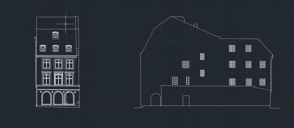

12 RENOVATION/ RECONSTRUCTION 12

13 BUILDING CONTROL As construction progresses, laser scanning data can be used to compare the newly constructed work against the as-designed model or drawings for quality assurance. As the construction ends the new facility will have as built 3D documentation from all major milestones in project. 13


14 During building control areas that have irregular forms and which are essential for correct project completion 14

15 BIM The building construction industry is just in the beginning phases of adopting laser scanning as an integral part of a BIM process. The first step is understanding how and where laser scanning fits into the design and construction process and the value or return on investment. 15

16 BIM Building information model Renovation - Inaccurate drawings; - No drawing at all; - Design from point cloud; - Accurate flor plans; - Accurate elevation views. Construction validation - Detect issues that can`t be seen with naked eye; - Evaluate work on daily/weekly basis; - Orientated to match the model coordinate system; - Analysed to find clashes or deviations. 16


17 H2O CENTRE - 15 min to capture many million points, from which you can create everything you need for a successful project 17

18 THANK YOU
2/19/2018. Who are we? Who am I? What is Scanning? How does scanning work? How does scanning work? Scanning for Today s Surveyors
 2/19/2018 Who are we? Scanning for Today s Surveyors Survey, GIS, and Construction dealer Founded in 1988 Employee Owned Headquartered in Bismarck, ND States covered: ND, SD, MN, MT, WY, CO, UT, ID, WA,
Reality Capture: From Point Cloud To Design To Visualisation. by Shuaib Yunos, Baker Baynes
 Reality Capture: From Point Cloud To Design To Visualisation by Shuaib Yunos, Baker Baynes Perspective: Design & Construction Designers are conceiving buildings differently. Building owners expect a lot
Introducing. GeoSLAM. The experts in go anywhere 3D mobile mapping technology. The Company. The Technology. The Applications. Strategic Partnerships
 Introducing GeoSLAM The experts in go anywhere 3D mobile mapping technology The Company The Technology The Applications Strategic Partnerships The Company Multipurpose Presentation Template 2 About Us
Reality Capture. Customer Case
 Reality Capture Customer Case Reality Capture customer case: MP-Map Oy Surveying company using FARO laser scanners MP-Map Oy is a construction surveying company with over 30 years of surveying experience
Geospatial Engineering Problems & Solutions Associated With NDP Roads, Tunnelling & Civil Engineering Projects Use of HDS Leica Laser Scanners
 Geospatial Engineering Problems & Solutions Associated With NDP Roads, Tunnelling & Civil Engineering Projects Use of HDS Leica Laser Scanners Laser Scanning Laser Scanning is a method of collecting large
BIM & Digital Transformation Scotland Live 2018 Capturing 3D Reality at the push of a button
 BIM & Digital Transformation Scotland Live 2018 Capturing 3D Reality at the push of a button Gary Kelly Country Manager Scotland Leica Geosystems @LeicaScot Capturing 3D Reality at the push of a button
Simplicity is the new black: The BLK360 story
 Simplicity is the new black: The BLK360 story Vanda KADLECIKOVA Leica Geosystems Heerbrugg, Switzerland E-mail: vanda.kadlecikova@leica-geosystems.com Abstract Meet the game changer. The new Leica BLK360
BIM for infrastructure make easy with Laser Scanner. 17 October Beng Chieh Quah Head of Marketing Asia Pacific
 BIM for infrastructure make easy with Laser Scanner 17 October 2016 Beng Chieh Quah Head of Marketing Asia Pacific who is? founded in 1981 NASDAQ since 1997 Global technology company Offering a range of
GeoSLAM Hub The complete software solution for GeoSLAM data
 GeoSLAM Hub The complete software solution for GeoSLAM data GeoSLAM.com GeoSLAM Hub A comprehensive software suite that turns GeoSLAM data into actionable information and valuable deliverables. A part
GeoSLAM Overview. The global leader in go anywhere 3D mobile mapping technology. 1
 GeoSLAM Overview The global leader in go anywhere 3D mobile mapping technology. 1 About GeoSLAM The global leader in go anywhere 3D mobile mapping technology. 2 Who We Are GeoSLAM is a global market leader
3D Terrestrial Laser Scanner Innovative Applications for 3D Documentation
 3D Terrestrial Laser Scanner Innovative Applications for 3D Documentation Rodney Chaffee Head of Sales, FARO Asia Pacific 3D Laser Scaning Market 2017 2.3 Billion $ 2012 1.3 Billion $ CAGR : > 12% Source:
Copyright ZEB-CAM User Guide 2018 GeoSLAM Ltd. All rights reserved.
 GeoSLAM ZEB-CAM UserGuide GeoSLAM.com Copyright ZEB-CAM User Guide 2018 GeoSLAM Ltd. All rights reserved. 2018 GeoSLAM Ltd 1 ZEB-CAM User Guide v3.0.0 CONTENTS Introduction... 5 1.1 Specification... 5
GeoSLAM Software. The complete end-to-end solution for GeoSLAM data. GeoSLAM.com
 GeoSLAM Software The complete end-to-end solution for GeoSLAM data GeoSLAM.com GeoSLAM Software Solutions GeoSLAM Hub & Draw is a comprehensive software suite that transforms 3D point cloud data into actionable
A New Protocol of CSI For The Royal Canadian Mounted Police
 A New Protocol of CSI For The Royal Canadian Mounted Police I. Introduction The Royal Canadian Mounted Police started using Unmanned Aerial Vehicles to help them with their work on collision and crime
GeoSLAM Overview. The experts in go-anywhere 3D mobile mapping technology
 GeoSLAM Overview The experts in go-anywhere 3D mobile mapping technology 1 About GeoSLAM The experts in go-anywhere 3D mobile mapping technology 2 Who We Are GeoSLAM is a global market leader in go-anywhere
LiForest Software White paper. TRGS, 3070 M St., Merced, 93610, Phone , LiForest
 0 LiForest LiForest is a platform to manipulate large LiDAR point clouds and extract useful information specifically for forest applications. It integrates a variety of advanced LiDAR processing algorithms
Overview of the Trimble TX5 Laser Scanner
 Overview of the Trimble TX5 Laser Scanner Trimble TX5 Revolutionary and versatile scanning solution Compact / Lightweight Efficient Economical Ease of Use Small and Compact Smallest and most compact 3D
Efficient and Effective Quality Assessment of As-Is Building Information Models and 3D Laser-Scanned Data
 Efficient and Effective Quality Assessment of As-Is Building Information Models and 3D Laser-Scanned Data Pingbo Tang 1, Engin Burak Anil 2, Burcu Akinci 2, Daniel Huber 3 1 Civil and Construction Engineering
Bentley Descartes and what s new in Descartes V8i (SELECTseries 3) What is Bentley Descartes? 2011 Bentley Systems, Incorporated
 What is Bentley Descartes? 2011 Bentley Systems, Incorporated") Bentley Descartes and what s new in Descartes V8i (SELECTseries 3) Tom Stogdill Bentley Systems, Inc. What is Bentley Descartes? Image Processing Raster Geo-Referencing Advanced raster transformation (warping,
Bentley Descartes and what s new in Descartes V8i (SELECTseries 3) Tom Stogdill Bentley Systems, Inc. What is Bentley Descartes? Image Processing Raster Geo-Referencing Advanced raster transformation (warping,
Suite en It Up with Autodesk ReCap
 Chad Studer ADSK Solutions RC3165 Static and mobile laser scanning technologies capture millions of points and provide photorealistic interactive virtual sites known as point clouds. With Autodesk ReCap
Copyright ZEB CAM User s Manual 2016 GeoSLAM Ltd. All rights reserved.
 Copyright ZEB CAM User s Manual 2016 GeoSLAM Ltd. All rights reserved. 2016 GeoSLAM Ltd 1 ZEB CAM User s Manual v1.0.0 2016 GeoSLAM Ltd 2 ZEB CAM User s Manual v1.0.0 CONTENTS Introduction... 5 1.1 Specification...
Don t Listen To Us Listen To Our Customers
 Don t Listen To Us Listen To Our Customers GeoSLAM.com The experts in go-anywhere 3D mobile mapping technology Architects, engineers, facility managers, surveyors they are all seeking ways to be more profitable,
HANDHELD MOBILE MAPPING / 3D LASER MAPPING SOLUTIONS. ZEB Family Brochure. geoslam.com
 HANDHELD MOBILE MAPPING / 3D LASER MAPPING SOLUTIONS ZEB Family Brochure geoslam.com NEW Long range, greater intensity, UAV ready HANDHELD BACKPACK UAV Effortless Data Capture Your tool to capture, view
A Sweet Success in Plant Documentation for Michigan Sugar Company
 A Sweet Success in Plant Documentation for Michigan Sugar Company COMPANY LOCATION 3D Imaging Services Flint, MI TOOLS USED Leica ScanStation P40 (solutionshardware-p40.html) Leica Cyclone Software (solutionssoftware-cyclone.html)
Trimble RealWorks. What s new in version 9.0
 Trimble RealWorks What s new in version 9.0 Trimble RealWorks v9.0 What s new Over 40 new features and enhancements Navigation and visualization improvements SketchUp interoperability Additional 3 rd party
Laser Scanning & Creation of 3D Models For BIM and Process Facilities
 Specialised Surveying Solutions Presented to: ICES UAE Region Abu Dhabi November 2009 Land and Engineering Surveying Services 3D Laser Scanning & Modeling Laser Scanning Technology Zoller+Fröhlich Phase
Most as-built information is still manually collected. Today s Design Market
 Agenda 1. Overview of 3D laser scanning 2. HDS 3D Laser scanning applications Leica ScanStation2 True Color Scan 3. Demonstration of HDS & Trueview 4. Questions and Answers The advanced 3D Laser Scanning
Engineering Systems Manager
 02/04/2006 1 Engineering Systems Manager Colin K Fairweather 02/04/2006 2 Point Cloud Data With PDMS On Brownfield Projects What are the benefits and why use the technology? 02/04/2006 3 The History of
Messerli Informatik GmbH EliteCAD ME V13 R2 update information 1
 Messerli Informatik GmbH EliteCAD ME V13 R2 update information 1 EliteCAD ME V13 R2 update information February 2016 This update of EliteCAD ME contains numerous improvements and optimizations which have
BEFORE YOU BUY: SEVEN CRITICAL QUESTIONS TO ASK ABOUT LASER SCANNERS. Robert Gardiner
 BEFORE YOU BUY: SEVEN CRITICAL QUESTIONS TO ASK ABOUT LASER SCANNERS Robert Gardiner Table of Contents Introduction... 3 Horizontal and Vertical Angular Accuracies... 4 Movement Tracking... 6 Range Limitations...
Copyright GeoSLAM Viewer User Guide 2017 GeoSLAM Ltd. All rights reserved. Version GeoSLAM Ltd 1 GeoSLAM Viewer User Guide v1.0.
 Copyright GeoSLAM Viewer User Guide 2017 GeoSLAM Ltd. All rights reserved. Version 1.0.0 2017 GeoSLAM Ltd 1 GeoSLAM Viewer User Guide v1.0.0 2017 GeoSLAM Ltd 2 GeoSLAM Viewer User Guide v1.0.0 CONTENTS
Rapid Building information modeling. Ivar Oveland 2013
 Rapid Building information modeling Ivar Oveland 2013 Case study How can I rapidly create a building information model? Today: Different methods are used today to establish a building information model
FARO As-Built for AutoCAD Software Versatile Reality to CAD Solutions
 FARO As-Built for AutoCAD Software Versatile Reality to CAD Solutions FARO As-Built for Autodesk Revit Creating Efficiencies in Scan Data Extraction for BIM FARO As-Built for AutoCAD Software TM Versatile
Surface Rendering. Surface Rendering
 Surface Rendering Surface Rendering Introduce Mapping Methods - Texture Mapping - Environmental Mapping - Bump Mapping Go over strategies for - Forward vs backward mapping 2 1 The Limits of Geometric Modeling
Digital Preservation of the Aurelius Church and the Hirsau Museum Complex by Means of HDS and Photogrammetric Texture Mapping
 Master Thesis Ruxandra MOROSAN Ruxandra MOROSAN Digital Preservation of the Aurelius Church and the Hirsau Museum Complex by Means of HDS and Photogrammetric Texture Mapping Duration of the Thesis: 6 months
How we build reality. Company Overview. Case Study Stonehenge in High Defi nition
 How we build reality Case Study Stonehenge in High Defi nition Company Overview Z+F is one of world leading manufacturers of phase based laser scanners. Our strengths lie in our powerful 3D laser scanning
Automated Processing for 3D Mosaic Generation, a Change of Paradigm
 Automated Processing for 3D Mosaic Generation, a Change of Paradigm Frank BIGNONE, Japan Key Words: 3D Urban Model, Street Imagery, Oblique imagery, Mobile Mapping System, Parallel processing, Digital
Marc De Bruyne 3D Design Improvement Leader, DOW Chemical
 Marc De Bruyne 3D Design Improvement Leader, DOW Chemical John Foster Director, Profox Companies DOW Chemical Terneuzen in the Netherlands Globally, second largest DOW site after Freeport US. Producing
NEW PERSPECTIVE SEPTEMBER 2017
 VOLUME 7 ISSUE 6 SEPTEMBER 2017 NEW PERSPECTIVE 18 26 38 POLARIS SHOWS THE WAY The terrestrial laser scanning market continues to evolve, providing today s practitioner with an abundance of options LITTLE
Extracting Plant Deliverables from AutoCAD Point Clouds
 Extracting Plant Deliverables from AutoCAD Point Clouds The webinar will begin shortly. You will hear silence until the webinar begins. Please note that this webinar is being recorded and all registrants
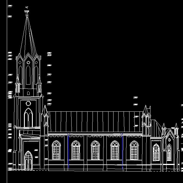
USE THE 3D LASER SCANNING FOR DOCUMENTATION THE RIGA CATHEDRAL IN LATVIA
 USE THE 3D LASER SCANNING FOR DOCUMENTATION THE RIGA CATHEDRAL IN LATVIA Maris Kalinka, Elina Rutkovska, Department of Geomatic, Riga Technical University, Azenes 16-109, Riga, Latvia, geomatika@geomatika.lv
Realworks Software. A Powerful 3D Laser Scanning Office Software Suite
 TECHNICAL NOTES Realworks Software A Powerful 3D Laser Scanning Office Software Suite Trimble RealWorks is a powerful office software that imports rich data from your 3D laser scanning instrument and transforms
Comparison of 3D Laser Scanning and Classical Survey Data Deformation Analysis of Industrial Facilities in Oil Refinery
 Comparison of 3D Laser Scanning and Classical Survey Data Deformation Analysis of Industrial Facilities in Oil Refinery Almin ĐAPO, Luka BABIĆ, Boško PRIBIČEVIĆ, Antonio ANTUNOVIĆ University of Zagreb,
Leica Pegasus: Backpack
 Leica Pegasus: Backpack Fast Acquisition Accurate data Indoor/Outdoor projects Pegasus:Backpack Simple workflow Everything, Everywhere 1 Leica Pegasus: Backpack Award Winning System Remarks Multiple Award
RealWorks Software. A Powerful 3D Laser Scanning Office Software Suite
 TECHNICAL NOTES RealWorks Software A Powerful 3D Laser Scanning Office Software Suite Trimble RealWorks is a powerful office software that imports rich data from your 3D laser scanning instrument and transforms
Scan-to-BIM. NEWBIM ApS, Galina Slavova CEO, BIM Specialist
 Scan-to-BIM NEWBIM ApS, Galina Slavova CEO, BIM Specialist Agenda What is Building Information Modeling (BIM) About NEWBIM ApS 3D Laser Scanning Integration Case Study Demonstration Building Information
TERRESTRIAL LASER SYSTEM TESTING USING REFERENCE BODIES
 TERRESTRIAL LASER SYSTEM TESTING USING REFERENCE BODIES Miriam Zámečníková and Alojz Kopáčik Department of Surveying, Faculty of Civil Engineering Slovak University of Technology Email: miriam.zamecnikova@stuba.sk
The Most Comprehensive Solution for Indoor Mapping Applications
 The Most Comprehensive Solution for Indoor Mapping Applications TRIMBLE INDOOR MOBILE MAPPING SOLUTION TRIMBLE INDOOR MOBILE MAPPING SOLUTION (TIMMS): HIGH EFFICIENCY, MAXIMUM FLEXIBILITY, ALL-IN-ONE PACKAGE
With FARO PointSense for Revit. Jörg Braunes Platform Owner Software Chris Palmer Sales Engineer 1
 From Point Clouds to BIM Models With FARO PointSense for Revit Jörg Braunes Platform Owner Software Chris Palmer Sales Engineer 1 Agenda Scan to BIM with Revit PointClouds in Revit Advanced Workflow with
Point clouds in BIM. IOP Conference Series: Earth and Environmental Science PAPER OPEN ACCESS
 IOP Conference Series: Earth and Environmental Science PAPER OPEN ACCESS Point clouds in BIM To cite this article: Gergana Antova et al 2016 IOP Conf. Ser.: Earth Environ. Sci. 44 042034 View the article
The benefit of Terrestrial Laser Scanner for archaeology
 The benefit of Terrestrial Laser Scanner for archaeology Christian RUDORFER City of Vienna / MA41 Urban Survey Abstract: In 2010, the MA 41 - Urban Survey of the City of Vienna decided to purchase a terrestrial
Terrestrial 3D laser scanning Practical aspects
 Terrestrial 3D laser scanning Practical aspects ISPRS WG VI/5&SC Summer School 2007 by Gregor Bilban 3D laser scanning Benefits Lower data collection costs Reduction or elimination of re-visits More accurate
INDOOR 3D MODEL RECONSTRUCTION TO SUPPORT DISASTER MANAGEMENT IN LARGE BUILDINGS Project Abbreviated Title: SIMs3D (Smart Indoor Models in 3D)
") INDOOR 3D MODEL RECONSTRUCTION TO SUPPORT DISASTER MANAGEMENT IN LARGE BUILDINGS Project Abbreviated Title: SIMs3D (Smart Indoor Models in 3D) PhD Research Proposal 2015-2016 Promoter: Prof. Dr. Ir. George
INDOOR 3D MODEL RECONSTRUCTION TO SUPPORT DISASTER MANAGEMENT IN LARGE BUILDINGS Project Abbreviated Title: SIMs3D (Smart Indoor Models in 3D) PhD Research Proposal 2015-2016 Promoter: Prof. Dr. Ir. George
A selection of our previous clients:
 Survey Solutions Geo-Spatial Survey Solutions Ltd Contact: Tel: Email: Y X Roger Davies 07713 160041 roger.davies@geo-spatial.co.uk www.geo-spatial.co.uk A selection of our previous clients: English Heritage
VGMETROLOGY. Maximum Precision, Minimal CT Data Set Sizes
 VGMETROLOGY Maximum Precision, Minimal CT Data Set Sizes Full-featured but nonetheless easy-to-use VGMETROLOGY is made for metrologists. The Universal Metrology Solution VGMETROLOGY is made for metrologists.
Geospatial database for heritage building conservation
 IOP Conf. Series: Earth and Environmental Science 18 (2014) 012087 doi:10.1088/1755-1315/18/1/012087 Geospatial database for heritage building conservation W N F W A Basir1,3, H Setan1, Z M ajid1, A Chong2
BIM PROCESS COMPARING NEW BUILD WITH EXISTING ASSETS A VERY QUICK SUMMARY OF THE PROCESS
 : STEPPING INTO THE FUTURE WITH THE PAST HYBRID MODELLING IN THE BIM PROCESS CARL BROOKES 8 DECEMBER 2017 INTRODUCTION Very quick summary of BIM process Comparing New build with existing assets 3D model
Overview and Agenda. (Green)BIM, Indoor Mobile Mapping - Innovative Ways to Scan Geomatic BIM education
BIM, Indoor Mobile Mapping - Innovative Ways to Scan Geomatic BIM education") CEGE Department - 3DIMPact of Civil, Environmental & Geomatic Engineering (CEGE) 3D Imaging, Metrology, Photogrammetry Applied Coordinate Technologies (3DIMPact) Chadwick GreenBIM Advancing Operational
CEGE Department - 3DIMPact of Civil, Environmental & Geomatic Engineering (CEGE) 3D Imaging, Metrology, Photogrammetry Applied Coordinate Technologies (3DIMPact) Chadwick GreenBIM Advancing Operational
Point Cloud - Polygon Mesh. Wannes Van Isacker - Industrial Design 15
 Point Cloud - Polygon Mesh Wannes Van Isacker - Industrial Design 15 3D-SCANNING About 3D Scanning To get started with 3D scanning you first have to understand a little how the scanner works. The scanner
Terrestrial Laser Scanning assignment
 Terrestrial Laser Scanning assignment Objective: Underground 3D survey using terrestrial laser scanning Location: Otaniemi campus, Innopoli 3 Business Area Equipment: Faro Focus 3D Methodology: Multiple
Developing a Network:
 Developing a Network: This is setting up IP addresses in properties in Local Area Connection in the Network and Sharing Centre in Control Panel. I deselected all of the networks checkboxes accept the TCP/IP4
The raycloud A Vision Beyond the Point Cloud
 The raycloud A Vision Beyond the Point Cloud Christoph STRECHA, Switzerland Key words: Photogrammetry, Aerial triangulation, Multi-view stereo, 3D vectorisation, Bundle Block Adjustment SUMMARY Measuring
Leveraging Point Clouds to Produce Accurate As-Built Models. Sonia Delgadillo
 Leveraging Point Clouds to Produce Accurate As-Built Models Sonia Delgadillo Time What is CADWorx fieldpipe? Easy customization Comprehensive specs Short learning curve AutoCAD -based CADWorx Plant Design
DRONE MAPPING FOR CONSTRUCTION
 DRONE MAPPING FOR CONSTRUCTION POWERFUL SOLUTIONS FOR AS-BUILT SURVEYS AND SITE DOCUMENTATION - AUTOMATED FLEXIBLE PROCESSING - REPEATABLE RELIABLE ACCURACY - APPLICABLE RESULTS WE CAPTURE IMAGES FROM
3D Laser Scanning Approaches and Business Models for implementing BIM in Facility Management
 3D Laser Scanning Approaches and Business Models for implementing BIM in Facility Management M.Sc. Zsuzsa Besenyői, HTW Berlin Prof. Dr.-Ing. Markus Krämer, HTW Berlin Dipl.-Ing. (FH) Frank Lindner, G2Plus
SAS 3D SPARK PVT LTD
 SAS 3D SPARK PVT LTD All Dimensions Covered About Us We are located in Bangalore, S.A.S 3D Spark Pvt Ltd is an engineering firm specializing in 3D scanning solutions. Our engineers and management have
REPRESENTATION REQUIREMENTS OF AS-IS BUILDING INFORMATION MODELS GENERATED FROM LASER SCANNED POINT CLOUD DATA
 REPRESENTATION REQUIREMENTS OF AS-IS BUILDING INFORMATION MODELS GENERATED FROM LASER SCANNED POINT CLOUD DATA Engin Burak Anil 1 *, Burcu Akinci 1, and Daniel Huber 2 1 Department of Civil and Environmental
CRONOS 3D DIMENSIONAL CERTIFICATION
 CRONOS 3D DIMENSIONAL CERTIFICATION This dimensional certification is structured as follow: 1. 2. 3. 4. 5. Test description Dimensional report basic workflow Dimensional report, acquisition field 18mm
ERROR SOURCES IN PROCCESSING LIDAR BASED BRIDGE INSPECTION
 The International Archives of the Photogrammetry, Remote Sensing and Spatial Information Sciences, XLII-/W7, 07 ISPRS Geospatial Week 07, 8 September 07, Wuhan, China ERROR SOURCES IN PROCCESSING LIDAR
Toward generation of a Building Information Model of a deformed structure using laser scanning technology
 Toward generation of a Building Information Model of a deformed structure using laser scanning technology R Zeibak-Shini, R Sacks & S Filin Technion Israel Institute of Technology, Israel Earthquakes are
Building Information Modeling
 Chapter Building Information Modeling 1 Building information modeling (BIM) is an integrated workflow built on coordinated, reliable information about a project from design through construction and into
Using SLAM-based Handheld Laser Scanning to Gain Information on Difficult-to-access Areas for Use in Maintenance Model
 Using SLAM-based Handheld Laser Scanning to Gain Information on Difficult-to-access Areas for Use in Maintenance Model T. Makkonen a, R. Heikkilä a, P. Tölli b, F. Fedorik a a Construction Technology Research
GCSE ICT AQA Specification A (Short Course) Summary
 Summary") GCSE ICT AQA Specification A (Short Course) Summary 9.1 The general structure of information systems Understand that information systems may be described in terms of inputs, storage, processing, outputs
GCSE ICT AQA Specification A (Short Course) Summary 9.1 The general structure of information systems Understand that information systems may be described in terms of inputs, storage, processing, outputs
Trimble Realworks Software
 TECHNICAL NOTES Trimble Realworks Software A Powerful 3D Laser Scanning Office Software Suite DESIGNED FOR TODAY S MULTIFACETED SCANNING PROFESSIONAL, TRIMBLE REALWORKS IS A POWERFUL OFFICE SOFTWARE THAT
INTEGRATING PHOTOGRAMMETRIC TECHNOLOGIES AND GEODETIC METHODS FOR 3D MODELING
 INTEGRATING PHOTOGRAMMETRIC TECHNOLOGIES AND GEODETIC METHODS FOR 3D MODELING Georgeta Pop Faculty of Geodesy, Geodesy and Photogrammetry Department, Technical University of Civil Engineering Bucharest,
technical notes trimble realworks software
 technical notes trimble realworks software A POWERFUL 3D LASER SCANNING OFFICE SOFTWARE SUITE Designed for today s multifaceted scanning professional, Trimble RealWorks is a powerful office software that
TERRESTRIAL LASER SCANNER DATA PROCESSING
 TERRESTRIAL LASER SCANNER DATA PROCESSING L. Bornaz (*), F. Rinaudo (*) (*) Politecnico di Torino - Dipartimento di Georisorse e Territorio C.so Duca degli Abruzzi, 24 10129 Torino Tel. +39.011.564.7687
ON THE ROAD JULY/AUGUST MAP PROJECTIONS The importance of horizontal and vertical datums in GIS mapping
 VOLUME 4 ISSUE 5 JULY/AUGUST 2014 ON THE ROAD 30 40 62 MAP PROJECTIONS The importance of horizontal and vertical datums in GIS mapping FOLLOW THE LEDDAR A special purpose sensor that does several 3D measurement
Streamline your office to field processes. Peter Madsen
 2017 Streamline your office to field processes Peter Madsen Introduction Improving your office>field>office workflows and processes Data Preparation Data Upload Field Process Coding / Stringing Object
Tools, Tips and Workflows Colorized Point Clouds take on Role of 3D Image
 l Karrie-Sue Simmers, Darrick Wagg 1-15-2013 Revision 1.0 In a visual world an image is easily recognizable to viewers when compared to a monochrome point cloud and can be one of the biggest challenges
Location Based Technology Expert. Mobile VR 3D modeling for BIM
 Location Based Technology Expert Mobile VR 3D modeling for BIM 50bln square meters indoor environment are waiting to be digitized and go online. So we need a way efficient enough to map the indoors VR
Comparing Aerial Photogrammetry and 3D Laser Scanning Methods for Creating 3D Models of Complex Objects
 Comparing Aerial Photogrammetry and 3D Laser Scanning Methods for Creating 3D Models of Complex Objects A Bentley Systems White Paper Cyril Novel Senior Software Engineer, Bentley Systems Renaud Keriven
Robust Automatic 3D Point Cloud Registration and Object Detection
 FEATURE EXTRACTION FOR BIM Robust Automatic 3D Point Cloud Registration and Object Detection BY DAVID SELVIAH This article presents a ground-breaking approach to generating survey data for a BIM process
Comparing Aerial Photogrammetry and 3D Laser Scanning Methods for Creating 3D Models of Complex Objects
 www.bentley.com Comparing Aerial Photogrammetry and 3D Laser Scanning Methods for Creating 3D Models of Complex Objects A Bentley White Paper Cyril Novel Senior Software Engineer, Bentley Systems Renaud
Tools, Tips and Workflows LP360 Under the Hood - The Conflation Point Cloud Task LP360
 Tools, Tips and Workflows LP360 Lewis Graham Revision 1.0 l In the January issue of GeoCue News, we discussed the new Point (PCT) overhaul that we released in LP360 2013.2. The focus of the last article
IMPROVEMENT OF AIRCRAFT MECHANICAL DAMAGE INSPECTION WITH ADVANCED 3D IMAGING TECHNOLOGIES
 IMPROVEMENT OF AIRCRAFT MECHANICAL DAMAGE INSPECTION WITH ADVANCED 3D IMAGING TECHNOLOGIES MARK MAIZONNASSE 60TH A4A NDT FORUM SEPTEMBER 2017, FORT LAUDERDALE, FL, USA BRIDGING PHYSICAL AND DIGITAL WORLDS
Real World to Virtual World. With Geomagic Design X
 Real World to Virtual World With Geomagic Design X About OR3D OR3D based in UK with offices in Wrexham (Wales) and Bristol (England) Cover the UK and Internationally UK s largest supplier of Geomagic software
Rapid generation of 3D GIS content from reality capture data sources. Keir Keightley, HDR
 Rapid generation of 3D GIS content from reality capture data sources Keir Keightley, HDR Purpose Why do we want 3D GIS content? A picture is worth a thousand words, and more, if you can navigate it in
Leica BLK360 Questions & Answers. Vers
 Questions & Answers Vers. 11.01.2017 What is it? 2 What is it? 3 What is it? Calibrated full spherical image, LED flash support 4 What is it? 5 A new, simple way to capture reality Speed On-the-fly image
Integrating the Generations, FIG Working Week 2008,Stockholm, Sweden June 2008
 H. Murat Yilmaz, Aksaray University,Turkey Omer Mutluoglu, Selçuk University, Turkey Murat Yakar, Selçuk University,Turkey Cutting and filling volume calculation are important issues in many engineering
Edocuments - Springboard. Cloud based managed document production. Getting Started..
 Edocuments - Springboard Cloud based managed document production About Springboard.. Springboard: an on-line managed document production application developed by Edocuments Ltd, designed to simplify the
Semi-Automatic Techniques for Generating BIM Façade Models of Historic Buildings
 Semi-Automatic Techniques for Generating BIM Façade Models of Historic Buildings C. Dore, M. Murphy School of Surveying & Construction Management Dublin Institute of Technology Bolton Street Campus, Dublin
Visual Imaging in the Electronic Age Assignment #3 Draft Geometry Capture
 Visual Imaging in the Electronic Age Assignment #3 Draft Geometry Capture Assigned: October 5, 2017 Due Date: TBA (October 2017) The above image is of the sculpture by James Mahoney, which was demonstrated
Integrated Field to Finish BIM for Surveyors. Boris Skopljak Market Manager, Trimble Geospatial Office Software
 Integrated Field to Finish BIM for Surveyors Boris Skopljak (boris_skopljak@trimble.com) Market Manager, Trimble Geospatial Office Software Agenda Trimble Introduction BIM relevance in Trimble Trimble
Freestyle 3D. Features and applications. Dr. Daniel Döring Team Lead Product Development Freestyle 1
 Freestyle 3D Features and applications Dr. Daniel Döring Team Lead Product Development Freestyle 1 3D scanning Building works: How to record data? How to check what has been built? How to fit in new parts?
Or select Reset button under the application button (3ds Max symbol top left of screen)
") 3ds Max Notes 1. Starting 3ds Max file Open 3ds Max If Welcome to 3ds Max menu appears then select New Empty Scene Or select Reset button under the application button (3ds Max symbol top left of screen)
3ds Max Notes 1. Starting 3ds Max file Open 3ds Max If Welcome to 3ds Max menu appears then select New Empty Scene Or select Reset button under the application button (3ds Max symbol top left of screen)
Automatic Pipeline Generation by the Sequential Segmentation and Skelton Construction of Point Cloud
 , pp.43-47 http://dx.doi.org/10.14257/astl.2014.67.11 Automatic Pipeline Generation by the Sequential Segmentation and Skelton Construction of Point Cloud Ashok Kumar Patil, Seong Sill Park, Pavitra Holi,
Leica 3D Disto PROJECTOR function for stair case applications
 Leica 3D Disto PROJECTOR function for stair case applications Workflow description: Measurement Stair Design Set Out of fixing points Preparing the measurement 1 mark 1 point on each wall of the stair
Reality Capture using: RPAS Technologies & Image Laser Scanners
 Reality Capture using: RPAS Technologies & Image Laser Scanners by Johan Erasmus (RPAS Technologies) & Barend Bornman (Image Laser Scanners) from Aciel Geomatics Laser Scanners High-Definition Surveying
PAGE LAYOUT IN GRAPHIC DESIGN Where do you start when you want to create an attractive and effective design?
 PAGE LAYOUT IN GRAPHIC DESIGN Where do you start when you want to create an attractive and effective design? Aims & Outcomes for this week: Aims: To understand the three main page layout conventions used