TOTAL STATION THE POWER OF ONE. One surveyor. One system. 1One company.
|
|
|
- Geraldine Moore
- 5 years ago
- Views:
Transcription

1 TOTAL STATION 5600 THE POWER OF ONE. One surveyor. One system. 1One company.


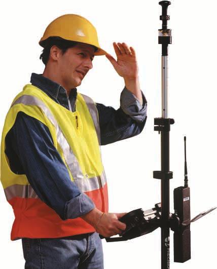
2 capabili THE POWER OF ONE. CONTROL TOPO DR REFLECTORLESS As a 21st-century surveyor, you face challenges undreamed of before. In a single day, you might be called upon to bring in a firstorder control point, then stake out a section of road grade, and finish up with a quick as-built audit on another site. More than ever that means moving mountains of data. You must translate complex CAD designs, work with conflicting datums and coordinate systems, generate sophisticated topo maps, and integrate measurements from a variety of instruments. That s tough enough in an office environment, but you know where the real work is done: In slushy snow, desert sun, and dusty construction sites. That s why at Trimble we ve been working toward a single goal: Giving you, the surveying professional, the capability to handle anything that comes your way. We can simplify your job by providing a single system so versatile it can handle virtually every facet of surveying, from concept to completion. Run by a multi-tasking controller that speaks to office computers and both GPS and conventional field instruments with no translation or interfacing issues, in a format that s so easy to use apprentices will be as productive as old pros. All supported by the same innovative spirit that brought you the first EDM, the first robotic total station, and the first real-time kinematic GPS system. With the 5600 Total Station series we ve achieved our goal. One system. One surveyor. One partner to turn to for support: Trimble, the number one supplier of complete surveying solutions.


3 y TOTAL STATION 5600 INTEGRATED SURVEYING DESIGN/DATA EXCHANGE STAKEOUT DTMS & VOLUMES GIS & AS-BUILT
![produc DOUBLE YOUR PROFIT. [SERVO] INCREASE PRODUCTIVITY 30%. [AUTOLOCK] UPGRADE TO AUTOLOCK AND YOU ADD ANOTHER 20% PRODUCTIVITY.](/docs-images/94/119876397/images/4-0.jpg "To be competitive these days, you need to work fast and work smart every step of the way.")

4 produc DOUBLE YOUR PROFIT. [SERVO] INCREASE PRODUCTIVITY 30%. [AUTOLOCK] UPGRADE TO AUTOLOCK AND YOU ADD ANOTHER 20% PRODUCTIVITY. To be competitive these days, you need to work fast and work smart every step of the way. If you want to be profitable, you can t waste time fiddling with finicky instruments or manually juggling complex data translations. Getting the job done fast while still producing accurate, high-quality results is critical for you and your clients. The Trimble 5600 Total Station series gives you access to the best, most-productive measuring methods available ideal for a wide range of applications. Each Trimble 5600 Total Station is an advanced surveying system for today s surveyor. With its innovative technology, each instrument allows you and your survey crews to survey faster, easier, and better than ever before. FAST. Equipped with a 4-speed servo, the 5600 series instruments allow for fast, smooth, accurate aiming. Servo technology enables automated measuring processes. To measure a set of angles for example, simply aim the instrument at each point just once. You can then let the instrument repeat the measurements automatically. As many times as needed. And as your job requirements grow, so can your 5600 series instrument. The servo system provides the base for upgrades to Autolock and robotic surveying. EFFICIENT. To further increase productivity, upgrade your 5600 series instrument to Autolock a semi-robotic measuring method where measuring and recording occur at the total station. With Autolock, the instrument seeks out the RMT (active remote positioning target), locks to it, and follows as the target is moved from point to point. Autolock looks only for the RMT, so there is never a problem that measurements are taken to other reflective objects. Autolock technology eliminates the need for time-consuming, error-prone focusing and allows you to work effectively even in poorand low-visibility environments. Using Autolock, it is now possible to survey and stakeout as quickly as the rodman can move getting the job done quickly and accurately.
![ivity TOTAL STATION 5600 [ROBOTIC] UPGRADE TO ROBOTIC AND YOU INCREASE PRODUCTIVITY ANOTHER 30%. [DIRECT REFLEX] INNOVATIVE DIRECT REFLEX DR200+ EDM MEASUREMENT SYSTEM.](/docs-images/94/119876397/images/5-0.jpg "[INTEGRATED SURVEYING ] COMBINE THE 5600 WITH A GPS SYSTEM AND HAVE THE BEST OF BOTH WORLDS. ONE-PERSON SURVEYING.")


5 ivity TOTAL STATION 5600 [ROBOTIC] UPGRADE TO ROBOTIC AND YOU INCREASE PRODUCTIVITY ANOTHER 30%. [DIRECT REFLEX] INNOVATIVE DIRECT REFLEX DR200+ EDM MEASUREMENT SYSTEM. [INTEGRATED SURVEYING ] COMBINE THE 5600 WITH A GPS SYSTEM AND HAVE THE BEST OF BOTH WORLDS. ONE-PERSON SURVEYING. For true one-person surveying, robotic operation enables you to now survey and stakeout on your own from the prism further increasing your productivity and reducing your labor and travel costs. Robotic is ideal for both survey and stakeout work. When surveying in robotic mode, simply take the control unit with you to the prism to record measurements and collect other data. For stakeout, use the control unit to navigate to the point. Robotic operation ensures higher data quality, because you are taking the measurements at the point being measured, where errors can be quickly identified and corrected. The 5600 series Robotic option uses a radio to communicate between the total station and the prism. The control unit gives you complete remote control of the instrument and its functions. INNOVATIVE. The innovative Direct Reflex (DR) EDM option is ideal for surveying where the target is difficult, impossible or dangerous to reach. It opens up a world of new applications building elevation surveys, tunnel profiling, measuring to objects on private land, and safe positioning of points in active traffic on roads and railways. The DR measurement system is equipped with purpose-built software tools that automate and control the measurement of complex points. Surface and line intersection, plane intersection, and automated scanning are tools that will help you get the job done. Using the DR200+ you can measure to white objects up to 600 meters away and to Kodak Grey up to 200 meters away. (Kodak Grey is the international standard to determine the range of reflectorless total stations.) And the range when using a single prism is 5.5 kilometers. The DR200+ helps you survey faster and more safely than ever before. SYNERGY. The 5600 Total Station series is the ideal complement to the Trimble GPS Total Station 5700, providing a means of filling in detail that cannot be acquired using GPS alone. A two-person crew can work independently or together, with the technology that suits the job to attain the highest possible productivity. The two are seamlessly linked using our universal controller, the TSCe. You can instantly switch between RTK and total station measurements. All the combined data can be processed and analyzed within the Trimble office software environment.

6 flexi ONE INSTRUMENT. MANY CONFIGURATIONS. FULLY UPGRADABLE Protect your investment. With Servo as standard, you have the option of either conventional or DR measurements. And for faster, more productive surveying, each 5600 Total Station series is fully upgradable to Autolock and Robotic technology. GEODIMETER TECHNOLOGY Tried, tested, and proven Geodimeter EDM. Using DR reflectorless technology, your survey crews can measure up to 600 meters without a prism and to 5500 meters with a single prism. ACTIVE TARGET TECHNOLOGY Reduce operator fatigue and increase productivity. The unique active target tracking gives 100% reliable target acquisition. TRACKLIGHT LINE OF SIGHT INDICATOR Improve productivity. A highly visible red, white, and green light allows your crews to stake out faster than ever. FOUR-SPEED SERVO For smooth, fast, accurate, and automatic aiming. DETACHABLE CONTROL UNITS Flexibility to select the right interface. A variety of user interfaces and control units can be used with the 5600 series, allowing you to select the interface that best suits your organization, work, and special applications.

7 ility TOTAL STATION 5600 LIGHTWEIGHT RMT TARGET 360 active target and mini-prism for 350 m range in robotic surveying, enabling you to complete the big jobs faster than ever before. Geodimeter Control Unit Zeiss Elta / Open System Control Unit TSCe Controller Geodat Win Control Unit Flexibility is built in. At Trimble our goal is to design and build surveying tools that give you the flexibility to meet all your challenges today and tomorrow. Tools that simplify your complex tasks. Tools that are intuitive, easy to use, and meet your requirements whatever the situation. Advanced technology, upgrade options, and a selection of user interfaces from the Trimble Toolbox to best suit your work give you the versatility you need for highly productive operations. And you can be sure you have made a sound investment upgrade options can adapt your instrument to your changing needs as your work challenges change. At Trimble we know that the real key to productive survey and stakeout work is in the software the user interface. That s why we offer you the flexibility to select from a variety of interfaces available in the Trimble Toolbox. You can work with the tool that is most familiar and best suited to your operations whether that be graphical or text-based, an on-board control unit or a separate controller. Additionally, you can use the same interfaces with our other surveying instruments. Simply take the control unit or controller with you as you change from working with your 5600 Total Station series instrument to the GPS Total Station The Total Station 5600 series can be operated with your preferred data collection or field computation system Geodimeter, Zeiss Elta and Trimble. Or you can take advantage of our Open System DOS control unit to run your favorite software TDS, SMI and more directly on board. SUPER-LIGHT TELESCOPIC POLE Carbon fiber telescopic rod with a built-in power supply. And for perfect balance the center of gravity is at the handgrip.


8 advanced t A SYSTEM YOU CAN RELY ON. Reliability, productivity, and simple operation are the three cornerstones of the Trimble Total Station 5600 series. And through the integration and evolution of field-proven Geodimeter technology, it is the most reliable Total Station for your work today. With the 5600 series, you have the flexibility to select the right technology for your work 4 speed servo, active target technology and search mechanism, long range direct reflex, and upgradability to Autolock and Robotic. Each instrument is a single, powerful tool ideal for handling all your measurement operations from initial concepts to final completion. Using the Trimble 5600 series, you can depend on getting performance and results. From the big jobs to the small ones, from the arctic to the humid tropics, the instrument is designed and built to work where you want to work. The Trimble 5600 series has the patented and proven search system that ensures surveying quality. This means you can be absolutely sure that the instrument locks onto and measures the right target, the RMT reflector. The instrument only senses the coded signal emitted by the infrared (IR) diode on the RMT. Active Target emits coded control signal that is detected by the instrument The DR200+ measurement technique is based upon the pulsed measurement principle this means the time taken for a very short light pulse to travel to the target and back is measured. What makes the Trimble technique unique is the way in which we determine the shape of the pulse before computing the transmit time. In this way, the influence of noise can be greatly reduced. That s why the range of our DR200+ EDM is so long without degradation of its accuracy. Typical ranges for DR 200+ Dark rock 150 m Wood 200 m Concrete 300 m

9 chnology TOTAL STATION FEATURES MODELS The Trimble 5600 series consists of four total station models. Each model differs from the others only in its accuracy, as follows: Overview of upgrades and options Model: Trimble Total Station 5601 Trimble Total Station 5602 Trimble Total Station 5603 Trimble Total Station 5605 Accuracy 1 /0.3 mgon 2 /0.5 mgon 3 /1.0 mgon 5 /1.5 mgon 1. Standard side cover 2. Radio side cover 3. Internal battery 4. Tracklight 5. Tracker 6. Geodimeter Control Unit, numeric 7. Geodimeter Control Unit, alphanumeric 8. GeodatWin Control Unit 9. Zeiss Elta / Open System Control Unit 10. TSC1 Controller 11. TSCe Controller 12. Field software 13. Range m, 1 prism Range m, 1 prism Range m, 1 prism Range m, 1 prism 14. DR Accuracy 0.3 mgon 1" Accuracy 0.5 mgon 2" Accuracy 1.0 mgon 3" Accuracy 1.5 mgon 5" 16. Panel attachment 17. Card memory 18. RMT Mini 19. RMT Long Range 20. RMT/TS 21. Telescopic range pole 22. External radio 23. Holder for keyboard unit and external radio 24. Large tiltable reflector DR Conventional surveying Surveying with AUTOLOCK Robotic surveying 24 ACCURACY Distance measurement typically ±(2 mm + 2 ppm) ±(0.007 ft + 2 ppm) M.S.E. (Direct Reflex ±(3 mm + 3 ppm) (0.01 ft + 3 ppm) RANGE 1200 to 2500 meters (0.7 miles to 1.6 miles) to one prism depending on instrument version. Direct Reflex: 200 meters (656 ft) to Kodak Gray (typically 600 meters (1968 ft) to a white object and 5500 meters (3.4 miles) to a single prism). MEASURING TIME Standard measurement 3.5 sec. Fast standard 1.3 sec. Fast tracking 0.4 sec. ELECTRICAL Light source: Infrared GaAs diode. (Direct Reflex: IR laser diode, 850 nm) Batteries: Rechargable NiMH Power consumption A depending on use of servo, tracker, radio, and type of measurement mode. MECHANICAL AND ENVIRONMENTAL Aiming: 4-speed servo drive. Endless fine adjustment. Leveling: 2-axis level in the LC display. Telescope: Coaxial with 26X magnification (30X optional). Field of view 2.6 meters at 100 meters (8.6 ft at 330 ft). Illuminated crosshair (15 steps). Operating temperature: -20 C to +50 C (-5 F to +122 F) Many options no compromises. Choice usually also means leaving things out. This is not the case when you choose the Trimble 5600 series. Whichever version you choose, the simplest or the most advanced, you keep all your options open for the future. You always have the option to upgrade and allow the surveying system to grow with the task. All you have to do is decide the level you need for your current surveying requirements. Do you need the highest possible surveying capability immediately or does a servo-driven Total Station suffice? With the Trimble 5600 series, you get what you need today without compromising your future. COMMUNICATIONS Data input/output: RS-232 two-way communication. Radio: Range approx meters (1 mile). Output 100mW to 500mW (differs from country to country depending on local legislation).


10 interope INTEGRATED SURVEYING Total Station. Total solution. When you invest in a Trimble 5600 Total Station series, you get more than just an advanced survey instrument much more. Because a 5600 series instrument is really a complete surveying solution. A servo-driven total station, which, through modular upgrades, can become an Autolock or robotic total station. With DR200+ technology built in, the instrument is capable of measuring to any object up to 600 m away without a prism! All Trimble products are supported with powerful field and office software, which integrate seamlessly with the instrumentation. All are designed by Trimble and linked together through the Trimble Toolbox environment, which is rapidly becoming the world standard for high-performance surveying. Seamless data flow. In the Trimble Toolbox environment, a single controller handles all of your instruments from mechanical and robotic total stations to RTK GPS receivers, even instruments from other manufacturers. All with seamless plug and play simplicity. You can change instrument types on the fly the survey controller automatically combines and correlates the different measurements into a single, unified dataset. Back in the office, the control unit interfaces directly to Trimble Geomatics Office software a single comprehensive program for all your data processing needs. No matter how your clients want their data delivered, the software is ready to automatically translate your field data into more than 50 design, CAD, GIS, and survey formats. There s even a Trimble Link module that lets you directly move your field data into the AutoDesk AutoCAD Land Development Desktop Top left: See your survey data in real time, as you survey it! Top right: Simple 3D arrows get you to the point when staking out with robotic, servo, and conventional total stations. MANY TYPES OF INSTRUMENTS Take continuous alignments to the field and view your position on the road in real time.


11 ability TOTAL STATION 5600 design package for analysis. Or, for inhouse design work, use the Terramodel software, Trimble s advanced design application for complete concept-to-completion integration. When your clients are ready to give their construction designs back to you for stakeout, the translation is just as seamless. Our new RoadLink Wizard automates the process for more than 30 road design software formats. find it more productive, you can add a Trimble GPS Total Station system and continue surveying by yourself without any interruption. For large sites, add a Trimble GPS system to rapidly cover open areas and positions not readily accessed with the total station, and continue surveying by yourself with no interruption. Field efficiency. The tight integration of the Trimble 5600 series will radically boost your productivity in the field. The combination of robotic and DR200+ measurement techniques creates the ultimate measuring machine, making it easy for a single surveyor to go anywhere and carry out any job previously carried out by an entire crew. You can upload your entire continuous 3-dimensional design to the survey controller, which allows you to put the pole down anywhere on site and instantly see the station, offset, cut or fill. Even if someone parks a bulldozer in your path, you can work right around it. And if you Integration, interoperability, and seamless compatibility. It all ads up to the power of one one surveyor, one system, one company. Trimble. 50 TYPES OF DATA The Trimble Toolbox also includes powerful software for civil engineering design, visualization, geodetic surveying and real time deformation monitoring. Process GPS and Conventional survey data with Trimble Geomatics Office and link to more than 50 types of survey, GIS, CAD & design data.

12 TRIMBLE. THE WORLD LEADER IN INTEGRATED SURVEY SOLUTIONS In the 20th century, Geodimeter, Trimble, and Zeiss revolutionized the world of surveying with the first automatic level, the first EDM, the first Robotic Total Station, the first commercial GPS receiver, and the first Real-Time Kinematic surveying system. Now in the 21st century, the new combined force of Trimble is bringing that same pioneering spirit to bear on practical solutions for the new challenges that will face the surveyor in the new millennium. We re closing the gap between field and office with integrated products that offer real-time data management, real-time data exchange, and real-time quality control from Concept to Completion. The new Trimble Toolbox offers the most comprehensive survey toolset in the world. With sales and support facilities around the globe, all interconnected with advanced global communications technology, we re ready to provide expert support anywhere your work takes you, 24 hours a day. Welcome to the 21st century. NORTH AMERICA Trimble Navigation Limited Engineering and Construction 5475 Kellenburger Road Dayton, Ohio Toll Free Main Fax EUROPE Trimble GmbH Am Prime Parc 11 D Raunheim Germany Main Fax LATIN AMERICA Trimble Navigation Limited 6505 Blue Lagoon Drive Suite 120 Miami, FL Toll Free Main Fax AFRICA & MIDDLE EAST Trimble P.O. Box Jebel Ali Free Zone Dubai UAE Main Fax ASIA-PACIFIC Trimble Navigation Australia PTY Limited Level 1/123 Gotha Street Spring Hill, QLD 4004 AUSTRALIA Main Fax CHINA Trimble Export Limited Representative Office Suite 16D, Building 2, Epoch Center 4 Beiwa Road, Haidian District Beijing, P.R. China, Main Fax Your Local Trimble Office or Representative Copyright 2001, Trimble Navigation Limited. All rights reserved. Elta, Geodat, Geodimeter, GPS Total Station and Terramodel are trademarks of Trimble Navigation Limited registered in the United States Patent and Trademark Office. The Globe and Triangle, Trimble, Autolock, Tracklight, Integrated Survey, RoadLink, Trimble Geomatics Office, Trimble Link, Trimble Survey Controller, TSC1 and TSCe are trademarks of Trimble Navigation Limited. All other trademarks are the property of their respective owners. TID 12411B (07/01)
Total Station Series 3000
 Total Station Series 3000 OPTIMIZED FOR PERFORMANCE Advanced Technology Integrated Surveying Maximum Versatility Direct Reflex Capability Optimized for Performance 3600 DR REFLECTORLESS 3300 DR REFLECTORLESS
HV601/HV602 for General Construction
 HV601/HV602 for General Construction CONTROL YOU CAN RELY ON Accurate Versatile Fast Easy to Use Precision Leveling and Aligning Maximum Versatility The Spectra Precision Laser HV601 and HV602 from Trimble
TECHNICAL NOTES TRIMBLE SURVEY CONTROLLER SOFTWARE
 TRIMBLE SURVEY CONTROLLER SOFTWARE TECHNICAL NOTES The Trimble Survey Controller software is the data collection solution that will make your survey work faster, easier, and more productive than ever before.
Trimble. LM80 Layout Manager A BLUEPRINT FOR SUCCESSFUL LAYOUT. Easy to Use Increased Productivity Minimum Errors and Rework Maximum Reliability
 Trimble LM80 Layout Manager A BLUEPRINT FOR SUCCESSFUL LAYOUT Easy to Use Increased Productivity Minimum Errors and Rework Maximum Reliability In a Class of its Own The Trimble LM80 is a revolutionary
TechnicalNotes. Trimble Geomatics Office Software
 TechnicalNotes Trimble Geomatics Office Software AT LAST A SINGLE SOFTWARE PACKAGE TO HANDLE ALL OF YOUR SURVEY DATA The Trimble Geomatics Office software is a key component in the Trimble Toolbox of Integrated
TECHNICAL NOTES SURVEY PRO WITH TSX
 SURVEY PRO WITH TSX TECHNICAL NOTES Survey Pro software from TDS is the data collection solution of choice for most North American surveyors 1. And with the addition of the Trimble TSX (Trimble Systems
TRIMBLE GEOMATICS OFFICE TECHNICAL NOTES
 The Trimble Geomatics Office software is an important part of Trimble s total surveying solutions. Never has the collection, processing, and management of survey data been so easy. Surveyors and engineers
GPS TOTAL STATION THE POWER OF ONE. One surveyor. One system. 1One company.
 GPS TOTAL STATION THE POWER OF ONE. One surveyor. One system. 1One company. capability THE POWER OF ONE. GPS TOTAL STATION CONTROL TOPO INTEGRATED SURVEYING DESIGN/DATA EXCHANGE STAKEOUT DTMS & VOLUMES
The Trimble 3D Scanning Solution: Designed by Surveyors for Surveyors
 The Trimble 3D Scanning Solution: Designed by Surveyors for Surveyors TRIMBLE 3D SCANNING Designed by surveyors for surveyors, the Trimble 3D scanning solution follows the surveying workflow you re familiar
Trimble Productivity: Finish Faster with Fewer Machines. GCS600 Grade Control System
 Trimble Productivity: Finish Faster with Fewer Machines GCS600 Grade Control System for Excavators Flexible, Affordable and Easy to Use Productivity and Payback in One Package: Looking for a flexible,
TechnicalNotes. Trimble Total Control Software
 TechnicalNotes Trimble Total Control Software POWERFUL GEODETIC CONTROL FOR ALL SURVEY PROJECTS A survey is only as good as its control elements. Trimble Total Control software puts you in total control
technical notes Trimble survey controller field software
 Trimble survey controller field software technical notes For more than a decade, Trimble Survey Controller field software has provided land surveyors with a complete GNSS and optical data-collection solution
TRIMBLE S6 ACCESSORIES BUNDLES GUIDE
 TRIMBLE S6 ACCESSORIES BUNDLES GUIDE TRIMBLE S6 SERVO ACCESSORY KIT RECOMMENDATIONS SLSU-S2001 Servo Target Kit containing: 571126110 Prism: Reflector tiltable, large 63.5 mm (2.5 in) 571126311 Signal
TRIMBLE TOTAL STATIONS: TRUSTED TODAY, DESIGNED FOR TOMORROW.
 GEOSPatial SOLUTIONS Trimble S-SERIES TOTAL Stations TRIMBLE TOTAL STATIONS: TRUSTED TODAY, DESIGNED FOR TOMORROW. For more than a decade, on countless jobs all over the world, Trimble Robotic s have delivered
Trimble Survey Controller. Release Notes
 Trimble Survey Controller Release Notes Version 7.70 Revision A January 2001 Corporate Office Trimble Navigation Limited Technical Publications Group 645 North Mary Avenue Post Office Box 3642 Sunnyvale,
Trimble Survey Controller. Release Notes
 Trimble Survey Controller Release Notes Version 10.5 Revision A September 2002 Corporate Office Trimble Navigation Limited Engineering and Construction Division 5475 Kellenburger Road Dayton, Ohio 45424-1099
TECHNOLOGY SOLUTIONS TRANSFORMING CONSTRUCTION LAYOUT. Trimble Field Link TRANSFORMING THE WAY THE WORLD WORKS
 TECHNOLOGY SOLUTIONS TRANSFORMING CONSTRUCTION LAYOUT Taking full advantage of the Trimble Tablet s processor and multi-touch screen functionality, has been designed to work the way you work. Featuring
TechnicalNotes. Trimble Survey Controller v10.0 Software THE ADVANCED TOTAL FIELD SOLUTION FROM TRIMBLE
 TechnicalNotes Trimble Survey Controller v10.0 Software THE ADVANCED TOTAL FIELD SOLUTION FROM TRIMBLE The Trimble Survey Controller software utilizes more of your senses to make your survey work faster,
TechnicalNotes. Geodimeter Control Unit
 TechnicalNotes Geodimeter Control Unit THE ADVANCED TOTAL FIELD SOLUTION FROM TRIMBLE Today s land surveyors demand high productivity, total flexibility, and top quality from their instruments. The Trimble
trimble gnss surveying systems
 trimble gnss surveying systems TRIMBLE GNSS SYSTEMS: SOLVING YOUR CHALLENGES IN THE FIELD INDUSTRY-LEADING GNSS SOLUTIONS DESIGNED WITH THE SURVEYOR IN MIND Backed by a legacy of GNSS technology surveying
Trimble Railways GEDO Trolley System
 Trimble Railways GEDO Trolley System Trimble Railways GEDO Trolley System In the railway industry, projects require different applications of measurement techniques. The Trimble Railways GEDO Trolley System
technical notes Trimble survey Manager Software
 Trimble survey Manager Software technical notes Powerful field and office software for the acquisition, processing, and display of precise real-time surveys. Never has the integration of survey data from
GeoMax Total Station Zoom30 Series
 GeoMax Total Station Zoom30 Series GeoMax About Us GeoMax is an internationally active company developing, manufacturing and distributing quality construction and surveying instruments. We provide a comprehensive
High-End Surveying Precise, Fast and Intelligent. LEICA TPS1100 Professional Series
 High-End Surveying Precise, Fast and Intelligent LEICA TPS1100 Professional Series TPS1100 Professional Series More time for the essentials. Automated, practical programs are the main features of the TPS1100
Trimble Site EASY-TO-USE RELIABLE ACCURATE
 Trimble Site Positioning Systems ACCURATE RELIABLE EASY-TO-USE more tools for more jobs Estimators Bid Team Site Surveyor Data Manager Site Engineer/Grade Checker Site Foreman/Supervisor Project Manager
GeoMax Total Station Zoom30 Series
 GeoMax Total Station Zoom30 Series GeoMax About Us GeoMax is an internationally nology group with strong mar- The close cooperation within active company developing, ket positions within measure- the Hexagon
Geospatial GNSS Systems TRANSFORMING THE WAY THE WORLD WORKS
 Geospatial GNSS Systems GNSS Solutions Designed with the Surveyor in Mind POWERFUL TECHNOLOGY YOU CAN DEPEND ON NO MATTER WHAT THE CHALLENGE Whether you are climbing over rough terrain to collect topographic
trimble gnss surveying systems
 trimble gnss surveying systems TRIMBLE GNSS SYSTEMS: SOLVING YOUR CHALLENGES IN THE FIELD INDUSTRY-LEADING GNSS SOLUTIONS DESIGNED WITH THE SURVEYOR IN MIND Backed by a legacy of GNSS technology surveying
Leica TPS1200 Series High performance Total Station
 Leica TPS1200 Series High performance Total Station Leica TPS1200 Total Stations Packed with exciting new features, built for speed, accuracy, ease-of-use and reliability. Leica TPS1200 Total Stations
Provided by Xpert Survey Equipment Click Topcon GPT-8003A for Product Info and Updated Pricing GPT-8000A/GTS-810A SERIES AUTO TRACKING TOTAL STATION
 Provided by Xpert Survey Equipment Click Topcon GPT-8003A for Product Info and Updated Pricing GPT-8000A/GTS-810A SERIES AUTO TRACKING TOTAL STATION The Solo Survey System that puts you in control The
Trimble Total Stations
 Trimble Total Stations The Most Advanced Stations. The Ultimate in Efficiency. FASTER, EASIER AND MORE PRODUCTIVITY Our seven total stations, C3, C5, S5, S7, S9, S9 HP and the SX10; deliver even greater
Trimble Field Solutions in Surveying
 Trimble Field Solutions in Surveying Trimble Survey Controllers and Field Software A total approach to managing fieldwork. RELEASE THE FULL POTENTIAL OF YOUR SURVEYING GEAR AND YOUR BUSINESS Trimble controllers
Provided by Xpert Survey Equipment Click Topcon GPT-8205A for Product Info and Updated Pricing GPT-8200A/GTS-820A SERIES AUTO TRACKING TOTAL STATION
 Provided by Xpert Survey Equipment Click Topcon GPT-8205A for Product Info and Updated Pricing GPT-8200A/GTS-820A SERIES AUTO TRACKING TOTAL STATION The Solo Survey System that puts you in control The
Trimble. S6 Total Station. Demonstration Guide
 Trimble S6 Total Station Demonstration Guide Version 1.00 Revision A Part Number 022543-106 January 2005 Contact Information Trimble Geomatics and Engineering Division 5475 Kellenburger Road Dayton, Ohio
 MS Series MS05A / MS1A Ultra-high Precision Auto-tracking Total Station n 0.5 / 1 Angular Accuracy n High-Performance, versatile EDM n 0.5 mm Distance Accuracy n Optimised Auto-Pointing n Laser Option
TRIMBLE GPS SEARCH TECHNOLOGY FOR THE PROFESSIONAL SURVEYOR
 TRIMBLE GPS SEARCH TECHNOLOGY FOR THE PROFESSIONAL SURVEYOR BY TIM LEMMON AND CHRIS VAN DER LOO, TRIMBLE APPLICATIONS SPECIALISTS, WESTMINSTER, COLORADO, U.S.A. ABSTRACT The Global Positioning System (GPS)
Storage Tank Solutions TRANSFORMING THE WAY THE WORLD WORKS
 Storage Tank Solutions Trimble TX8 Scanner: A Revolution in 3D Scanning TRUE PERFORMANCE IN A REAL WORLD The Trimble TX8 laser scanner sets new standards for performance and ease of use in high-speed collection
Leica TPS800 Series Powerful, efficient, reliable and intuitive. PinPoint Technology
 Leica TPS800 Series Powerful, efficient, reliable and intuitive PinPoint Technology powerful Leica TPS800 Performance Series... Three classes of accuracy TPS800 total stations are available in angular
Trimble Total Stations
 Trimble s The Most Advanced Stations. The Ultimate in Efficiency. Trimble C3 Mechanical Trimble C5 Mechanical Trimble S5 Trimble S7 Trimble S9 Trimble SX10 Trimble s: trusted today, designed for tomorrow.
Realworks Software. A Powerful 3D Laser Scanning Office Software Suite
 TECHNICAL NOTES Realworks Software A Powerful 3D Laser Scanning Office Software Suite Trimble RealWorks is a powerful office software that imports rich data from your 3D laser scanning instrument and transforms
RELEASE NOTES. Trimble Access Software
 RELEASE NOTES Trimble Access Software Version 2017.11 Revision A March 2018 1 Legal Information Trimble Inc. www.trimble.com Copyright and Trademarks 2009 2018, Trimble Inc. All rights reserved. Trimble,
MS05AX / MS1AX. MS AX Series. Ultra-high Precision Auto-tracking Total Station
 MS AX Series MS05AX / MS1AX Ultra-high Precision Auto-tracking Total Station n 0.5 / 1 Angle Accuracy n Automated Matrix Detection n High-Performance, versatile EDM n 0.5 mm Distance Accuracy n Laser Option
RealWorks Software. A Powerful 3D Laser Scanning Office Software Suite
 TECHNICAL NOTES RealWorks Software A Powerful 3D Laser Scanning Office Software Suite Trimble RealWorks is a powerful office software that imports rich data from your 3D laser scanning instrument and transforms
Leica FlexLine TS06plus Top Precision meets High Efficiency
 Leica FlexLine TS06plus Top Precision meets High Efficiency The First Plus: Original Leica Geosystems Quality For most, quality is relative. Not so at Leica Geosystems. To ensure our instruments meet the
Leica FlexLine TS09plus Full Precision at High Performance
 Leica FlexLine TS09plus Full Precision at High Performance The First Plus: Original Leica Geosystems Quality For most, quality is relative. Not so at Leica Geosystems. To ensure our instruments meet the
GLOBAL SERVICES TRAINING SUPPORT REPAIR SERVICES
 GLOBAL SERVICES TRAINING SUPPORT REPAIR SERVICES GLOBAL SERVICES OVERVIEW Trimble s Global Services Division has Training, Support, and Repair Service programs dedicated to lowering our customers operational
GeoMax TPS family. Works when you do.
 Works when you do GeoMax TPS family GeoMax has a complete TPS portfolio to fulfill the needs of all users. Ensure ultimate reliability with GeoMax TPS systems even in challenging environments. Providing
technical notes trimble realworks software
 technical notes trimble realworks software A POWERFUL 3D LASER SCANNING OFFICE SOFTWARE SUITE Designed for today s multifaceted scanning professional, Trimble RealWorks is a powerful office software that
Leica Builder... Built to Build
 Leica Builder... Built to Build Leica Builder... Built to Build Instead of tediously setting up strings, with the Builder T100 my masons can start work right away. The Builder T100 or T200 can determine
technical notes trimble business center software
 technical notes trimble business center software A POWERFUL SURVEY DATA OFFICE SOFTWARE SUITE DESIGNED FOR TODAY'S FAST-PACED SURVEYING OFFICE, TRIMBLE BUSINESS CENTER SOFTWARE UNLOCKS THE POTENTIAL OF
Trimble Realworks Software
 TECHNICAL NOTES Trimble Realworks Software A Powerful 3D Laser Scanning Office Software Suite DESIGNED FOR TODAY S MULTIFACETED SCANNING PROFESSIONAL, TRIMBLE REALWORKS IS A POWERFUL OFFICE SOFTWARE THAT
LEICA TPS700 Performance Series
 LEICA TPS700 Performance Series TPS700 now with automatic for increased surveying performance and comfort LEICA TPS700 Performance Series... Do you have to solve various surveying tasks every day? Would
GeoMax GNSS ZGP800 Series. Works when you do
 GeoMax GNSS ZGP800 Series Works when you do GeoMax About Us GeoMax is an internationally active company developing, manufacturing and distributing quality surveying instruments. We provide a comprehensive
Trimble S6. General. The Trimble S6 Total Station provides the power and flexibility required by today\'s surveying professionals.
 Trimble S6 General Product Description Product Brochure The Trimble S6 Total Station provides the power and flexibility required by today\'s surveying professionals. /upload/165-868-5836.pdf Demonstration
Leica Builder... Built to Build
 Leica Builder... Built to Build Leica Builder... Built to Build Instead of tediously setting up strings, with the Builder T100 my masons can start work right away. The Builder T100 or T200 can determine
DATA COLLECTORS FC-100 / FC-2000
 FC-100 / FC-2000 DATA COLLECTORS Topcon Field Computers; FC-100 and FC-2000 Compact, ultra bright, sealed and sturdy field computers. The demands of modern field data collection and control have changed
Trimble 3D Laser Scanning TRANSFORMING THE WAY THE WORLD WORKS
 Trimble 3D Laser Scanning Speed, Precision and Versatility Complete Solutions for Every Challenge CAPTURE AND DELIVER PRECISE DATA. FASTER. For scanning professionals, speed and precision are critical.
Trimble MX2 mobile mapping
 Trimble MX2 mobile mapping user applications Point clouds within your reach The Trimble MX2 is a vehicle-mounted spatial imaging system which combines high resolution laser scanning and panoramic cameras
Leica System 1200 Software Integrated Software for GPS1200 and TPS1200
 Leica System 1200 Software Integrated Software for GPS1200 and TPS1200 Leica System 1200 Software System 1200 software includes SmartWorx the onboard TPS, GPS and RX1250 software and the Leica Geo Office
Leica TPS1200 Series High performance Total Station
 Leica TPS1200 Series High performance Total Station Leica TPS1200 Total Stations Packed with exciting new features, built for speed, accuracy, ease-of-use and reliability. Leica TPS1200 Total Stations
Leica FlexLine TS06plus Top precision meets high efficiency
 Leica FlexLine TS06plus Top precision meets high efficiency The First Plus: Original Leica Geosystems quality For most, quality is relative. Not so at Leica Geosystems. To ensure our instruments meet the
Leica TPS700 Automated Series Increased surveying performance and comfort. PinPoint Technology
 Leica TPS700 Automated Series Increased surveying performance and comfort PinPoint Technology Leica TPS700 Automated Series with automation for more comfort Do you have to solve various surveying tasks
A New Epic to a Legacy of Breakthrough Technology
 SOKKIA CLASSIC A New Epic to a Legacy of Breakthrough Technology Far from home, in the most demanding worksites, you need to rely on toughness and accuracy to pull you through. In the middle of the desert,
Trimble S6 and SPS700 Total Station Firmware
 Trimble S6 and SPS700 Total Station Firmware Release Notes Introduction Upgrading from a previous version Using Trimble S6/SPS700 firmware with other Trimble products New features/enha ncements Changes
Trimble Positioning for Automotive Applications
 Trimble Positioning for Automotive Applications Trimble at a Glance Core Markets Agriculture Construction Building Construction Geospatial Transportation Emerging Markets Automotive Rail A MARKET LEADER
LEICA T1800 TC1800 TCA1800
 30 40 50 LEICA T1800 TC1800 TCA1800 Equal to any survey task Theodolites and total stations with 1 accuracy Survey instruments for every task Leica theodolites and total stations of the 1800 class Survey
Trimble Business Center Software, v3.30
 Trimble Business Center Software, v3.30 We are pleased to announce a new version of the Trimble Business Center software, version 3.30. This new version includes over 30 new features and enhancements increasing
Leica TPS1200+ Series High performance Total Station
 PointSolutions www.pointsolutions-us.com Leica TPS1200+ Series High performance Total Station Leica TPS1200+ Total Stations Packed with exciting new features, built for speed, accuracy, ease-of-use and
tax incentives expire December 31, 2008! HURRY! Special pricing, financing plans and product specials inside PRECISION PRODUCTS
 Join the Team & Be Rewarded PRODUCTS valid through December 31, 2008 YEAR-END SPECIALS & FINANCING OPTIONS HURRY! Special pricing, financing plans and tax incentives expire December 31, 2008! product specials
Comprehensive Seismic Survey Design And Data Processing. Trimble GPSeismic TRANSFORMING THE WAY THE WORLD WORKS
 Comprehensive Seismic Survey Design And Data Processing Trimble GPSeismic GPSeismic GPSeismic has been continuously developed for over twenty-five years by engineers whose combined professional backgrounds
Provided by Xpert Survey Equipment Click Leica TS06 for Product Info and Updated Pricing. Leica FlexLine TS06plus Top precision meets high efficiency
 Provided by Xpert Survey Equipment Click Leica TS06 for Product Info and Updated Pricing Leica TS06plus Top precision meets high efficiency The First Plus: Leica Geosystems quality For most, quality is
3D Laser Scanning Technology. Fast, Safe, Accurate. Rugged hardware and powerful software combined with streamlined survey workflow
 3D Laser Scanning Technology Fast, Safe, Accurate Rugged hardware and powerful software combined with streamlined survey workflow Maptek specialises in the research, development and application of 3D laser
Trimble Engineering & Construction Group, 5475 Kellenburger Road, Dayton, OH , USA
 Trimble VISION Ken Joyce Martin Koehler Michael Vogel Trimble Engineering and Construction Group Westminster, Colorado, USA April 2012 Trimble Engineering & Construction Group, 5475 Kellenburger Road,
3300 Series. Commercial List Price. New York State Price List
 0000571703051 0000571703061 0000571703151 0000571703171 See end of page for standard accessories. Manual - Trimble 3300 Topo Software User Guide, English 25.00 20.00 Manual - Trimble 3300 Short Form User
Trimble s RoadLink Utility Tutorials
 Trimble s RoadLink utility is an interface between third-party road definitions and Trimble survey devices. It lets you import or key in road definitions, view them graphically, edit them if required,
OPEN-PIT MINE SCANNING IN INDONESIA, HYDRONAV SERVICES OF SINGAPORE
 OPEN-PIT MINE SCANNING IN INDONESIA, HYDRONAV SERVICES OF SINGAPORE TRIMBLE 3D SCANNING CASE STUDY BY PAUL BIDDISCOMBE Nusa Tenggara is the Indonesian name for the more than 500 islands east of Bali, running
X-PAD Ultimate. The Ultimate solution in the field. Works when you do
 Works when you do X-PAD Ultimate The Ultimate solution in the field X-PAD Ultimate is a tailored, flexible, modular, ideal, customised software for high end topographic tasks, such as measure, stake-out,
A new geodetic methodology for the accurate Documentation and Monitoring of inaccessible surfaces.
 A new geodetic methodology for the accurate Documentation and Monitoring of inaccessible surfaces. Ε. Lambrou, G. Pantazis Lecturers at NTUA School of Rural and Surveying Engineering National Technical
TRIMBLE PAVING SOLUTIONS MILL FILL
 TRIMBLE PAVING SOLUTIONS MILL FILL better from the ground up Today s road projects require contractors to work faster, with better accuracy, and with tighter control on costs. For the paving contractor,
trimble unmanned aircraft systems
 trimble unmanned aircraft systems FOR SURVEYING and MAPPING TRIMBLE UAS AERIAL IMAGING solution: INDUSTRY-LEADING UAS MAPPING SOLUTIONS FOR ALL YOUR APPLICATION NEEDS Trimble prides itself on being a leader
Leica Rugby 320 SG & 410/420 DG The toughest players on big fields
 Leica Rugby 320 SG & 410/420 DG The toughest players on big fields Provided by Xpert Survey Equipment Click Leica Rugby 420DG for Product Info and Updated Pricing n Construction n Machine Control n Agriculture
TRIMBLE ASPHALT PAVING SOLUTIONS
 TRIMBLE ASPHALT PAVING SOLUTIONS Mill Fill better from the ground up Today s road projects require contractors to work faster, with better accuracy, and with tighter control on costs. For the paving contractor,
Leica TDRA6000 Product Brochure
 Leica TDRA6000 Product Brochure Version 01/2009 www.leica-geosystems.com/metrology The Laser Station Leica TDRA6000 The Leica TDRA6000 Laser Station is a portable inspection system designed for precision
Leica FlexLine plus. Product Presentation V4.00
 Leica FlexLine plus Product Presentation V4.00 Leica FlexLine plus Table of contents 1. FlexLine plus - Product Concept 2. FlexLine plus - Hardware Features 3. FlexField plus - Onboard Firmware 4. FlexLine
TRIMBLE FIELD POSITIONING SOLUTIONS FOR GENERAL CONTRACTORS
 TRIMBLE FIELD POSITIONING SOLUTIONS FOR GENERAL CONTRACTORS Construction Layout for General Contractors SETTING THE STANDARD construction layout solution for the general contractor. With the increasing
Total Station. Trimble Total Station Family. Total Flexibility
 Total Station Trimble Total Station Family Total Flexibility 4700 modular system 4800 integrated system If you re like most surveyors, you never know what job you ll be faced with tomorrow. But now with
Trimble Survey Controller
 Trimble Survey Controller Getting Started Guide www.trimble.com Trimble Survey Controller Getting Started Guide Version 10.5 Revision A Part Number 571 702 061 September 2002 Corporate Office Trimble
S-650 Coupling Alignment System
 S-650 Coupling A new generation of 5-axis, real-time coupling alignment systems. Geometric Alignment Laser Systems The Best Choice in Coupling Alignment is Easy to See 1 Largest target cell size on the
GCS900 GRADE CONTROL SySTEmS LK Bu RADE G FINISH
 GCS900 GRADE CONTROL Systems BulK Grade take the guesswork out of earthworks Trimble sets the standard for construction technology by developing highly productive, integrated and innovative solutions for
DMC 8000 PowerCommand Integrated Power System Digital Controls
 DMC 8000 PowerCommand Integrated Power System Digital Controls Usability Cummins has taken the complexity out of your system with the DMC 8000 control platform making it easier to use, integrate and adapt
connecting your construction site
 TRIMBLE: Connecting Your Construction SitE connecting your construction site The Ultimate Data Management System Business Center Heavy Construction Edition (HCE) from Trimble is the only office software
AGRICULTURE CORRECTION SERVICES
 AGRICULTURE CORRECTION SERVICES NEW! CENterPoint RTX The new Trimble CenterPoint RTX Correction Service delivers GNSS enabled, repeatable 1.5-inch (4 cm) corrections to your receiver anywhere in the world.
CONNECTING THE WORLD TO A HIGHER STANDARD.
 Established in 1903, Siemon is an industry leader specializing in the design and manufacture of high quality, high performance low voltage infrastructure solutions and services for Data Centers, LANs and
technical notes Trimble business CenTer software trimble BuSineSS Center your Complete office Solution
 Trimble business CenTer software technical notes trimble BuSineSS Center your Complete office Solution designed for today's fast-paced surveying office, trimble Business Center unlocks the potential of
Optical Network Management System. Remote Testing, Network Monitoring, and Service Provisioning Solution for High-Quality Network Performance
 Optical Network Management System Remote Testing, Network Monitoring, and Service Provisioning Solution for High-Quality Network Performance JDSU Enabling Broadband and Optical Innovation Improving the
LANDINS Georeferencing and Orientation System
 LANDINS Georeferencing and Orientation System LANDINS Georeferencing and Orientation System Landins is a simple, turnkey position and orientation system for land-based mobile applications. It offers dependable
SINGLE SERVER INSTALLATION GUIDE
 SINGLE SERVER INSTALLATION GUIDE Trimble 4D Control Software Suite (Version 4.1) Introduction Installation suite Installing the system Checking the installation Legal Notices Version 1 Revision A January
Leica Rugby 320 SG & 410/420 DG The toughest players on big fields. Construction Machine Control Agriculture
 Leica Rugby 320 SG & 410/420 DG The toughest players on big fields Construction Machine Control Agriculture Leica Rugby 320 SG & 410/420 DG When accuracy is the goal, Leica Rugby makes the grade Making
Laser Rotators. Ready for the most challenging sites
 Laser Rotators Ready for the most challenging sites DURING ALL SEASONS Covering every need Construction sites can differ drastically, from modest jobs to compound designs. Construction professionals need
Adam Hammet & Anthony McClaren. Getting to know the Trimble SX10 Scanning Total Station - Inside and Out ISV Regional Conference 2017: Moama, NSW
 Adam Hammet & Anthony McClaren Getting to know the Trimble SX10 Scanning Total Station - Inside and Out ISV Regional Conference 2017: Moama, NSW Contents Difference between scanner and a Total station