Digital Silk Road: Digital Humanities Approach to Spatial Documentation of Cultural Heritage
|
|
|
- Job Henderson
- 5 years ago
- Views:
Transcription
1 Digital Silk Road: Digital Humanities Approach to Spatial Documentation of Cultural Heritage Asanobu KITAMOTO National Institute of Informatics / SOKENDAI

2 2014/02/23 Bam 10th Anniversary 2 Digital Silk Road Project Started in Digital Humanities: Collaborative work among informatics + humanities scholars. Databases and digital resources are publicly accessible on the Web.
3 2014/02/23 Bam 10th Anniversary 3 Digital Humanities Traditional Humanities (little collaboration) Text, image, etc. Digitization Annotation Evaluation Digital Archives Human reading Humanities Scholars problem Collaboration methodology Computer Scientists Machine reading Digital Tools Methodological Commons
.")
4 2014/02/23 Bam 10th Anniversary 4 Toyo Bunko Rare Books Digitization of 203 books, pages. Collection of relevant academic references. Manual input of captions and TOCs. OCR for full-text search (with errors).


5 2014/02/23 Bam 10th Anniversary 5 Dealing with Many Types of Data Text Map Photograph Gazetteer
6 2014/02/23 Bam 10th Anniversary 6 Linking Entities Across Sources Textual criticism Textual source A Place name S? Textual criticism Textual source B Place name T Place name U Geographic And Visual Relationship Data Source C, D, E Data criticism Place name V


7 Registration of Maps Geometric Correction Interactive Georeferencing Map 1 Map 2 Map 1 Map 2 A A B D C B A D A D D C A D B C C Register B B C All points are registered. Shapes are distorted. Single point is registered (but no other points). Shapes are not distorted. 2014/02/23 Bam 10th Anniversary 7
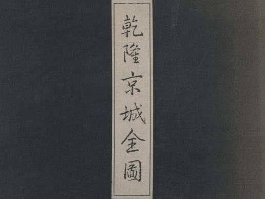

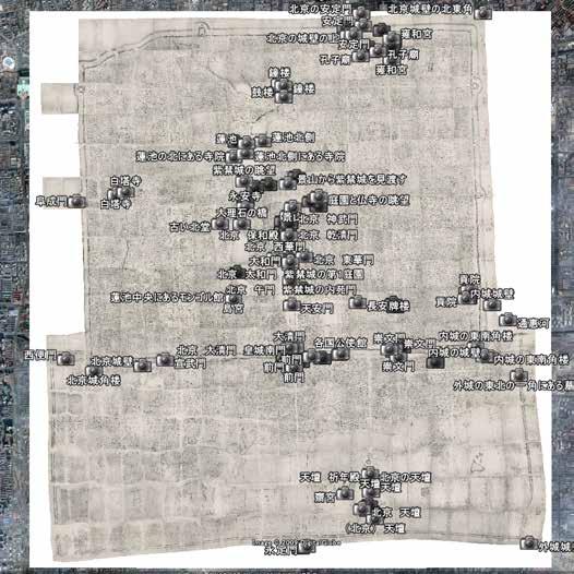
8 2014/02/23 Bam 10th Anniversary 8 Qianlong Map (Beijing)


9 2014/02/23 Bam 10th Anniversary 9 Massive Geometric Correction Huge size = W 13 m x H 14 m Many sheets = 203 sheets in total Massive pixels = 29 billion pixels Control points + lines: We proposed a new geometric correction.

10 2014/02/23 Bam 10th Anniversary 10 Aurel Stein Maps (Silk Road) Stein s map Innermost Asia was registered and displayed on Google Earth satellite images.
 Murtuk-ruins Yoghan-tura Chikkan-köl Bedaulat s town, Bēsh-kāwuk, Kosh-gumbaz")
11 2014/02/23 Bam 10th Anniversary 11 Problem of Missing Ruins Missing Ruins Yārkhoto Bezeklik Kara-khōja Toyuk Sirkip Chong-hassār, Kichik-hassār Lukchun Oi-tam, ruined fort Bögan-tura Buluyuk ( Shipang, Sassik-bulak, Kazma ) Murtuk-ruins Yoghan-tura Chikkan-köl Bedaulat s town, Bēsh-kāwuk, Kosh-gumbaz Yutōgh
12 2014/02/23 Bam 10th Anniversary 12 Different Conceptualization Ruin A in X Ruin E in Y Ruin C in Y Ruin D in Y Ruin B in X
 was digitized and geo-referenced.")
13 2014/02/23 Bam 10th Anniversary 13 Sven Hedin Maps Sven Hedin ( ) explored Persia and Central Asia. His map (1920s) was digitized and geo-referenced. Overlay on satellite images.

14 2014/02/23 Bam 10th Anniversary 14 Sven Hedin Maps (Iran)

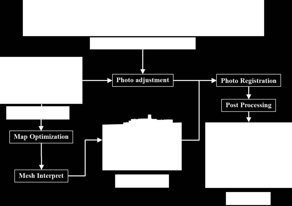
15 2014/02/23 Bam 10th Anniversary 15 Sven Hedin Maps (Tehran)

16 2014/02/23 Bam 10th Anniversary 16 Sven Hedin Maps (Bam)

17 2014/02/23 Bam 10th Anniversary 17 Aurel Stein s Visit to Bam in 1930s More interesting was a visit to large Arq of Bam. Once considered as the strongest fortress of Persia. Since its abandonment in the last century it is slowly crumbling to ruins. Archaeological Reconnaissances in North-Western India and South-Eastern Īrān : vol.1


18 2014/02/23 Bam 10th Anniversary 18 December 26, 2003


19 2014/02/23 Bam 10th Anniversary 19 Project History December 31, 2003 January 2004 April June, 2006 December 26, 2008
20 2014/02/23 Bam 10th Anniversary 20 Collaborators Dr. Elham Andaroodi Prof. Alireza Einifar Mr. Saeed Einifar (Razahang) Dr. Mohammad Reza Matini Leading the 3D CG reconstruction of Bam in terms collection and management of data, supervision of CG rendering teams, and the design of metadata-based ontology. Directing 3D CG drawing and modeling of buildings of the Citadel of Bam Conducting 3D CG drawing and Modeling of buildings of the Citadel of Bam Correcting, evaluating and completing 3D models, development of CAD-based 3D drawing.
21 2014/02/23 Bam 10th Anniversary 21 Project Framework Architectural Process Conceptual Process Museum exhibition Multimedia Rendering Website Physical reconstruction In the future Wireframe Modeling Ontology Heterogeneous data archives Cyber world After the disaster Voluntary data collection Institutional data collection Physical world

22 2014/02/23 Bam 10th Anniversary 22 Architectural Process High Accurate Manual Moderate Original image: Digital Globe Low Inaccurate Automatic Good balance between accuracy and cost
23 2014/02/23 Bam 10th Anniversary 23 Collaboration of Experts 1 st Phase (bad) 2 nd Phase (good) Domain Experts Instruct Check Domain Experts Create Modeling Create Rendering Create Modeling Rendering Transfer Create Computer Experts Computer Experts
24 2014/02/23 Bam 10th Anniversary 24 Modular Design Domain experts (e.g. architects) focus on the accuracy of models. Computer experts (e.g. CG engineers) focus on the appearance of rendered outputs. Separation of modeling and rendering made the architectural process more efficient. Modular design and the division of roles.


25 2014/02/23 Bam 10th Anniversary 25 Semi-Automatic Modeling Photogrammetric Map From CNRS and ICHHTO Photographs From experts and tourists Overlay Structure Simple 3D Model Texture Work by Mr. Natchapon Futragoon

26 2014/02/23 Bam 10th Anniversary 26 Workflow

27 2014/02/23 Bam 10th Anniversary 27


28 2014/02/23 Bam 10th Anniversary 28 Automatic Modeling Laser scanning Image: Wikipedia Structure from Motion Image: Building Rome in a Day New data cannot be measured for post-disaster reconstruction


29 2014/02/23 Bam 10th Anniversary 29 Multiple Images and Videos Using point correspondences and projective geometry fails due to the lack of photographs, variety of cameras, and temporal change due to renovation. 7-minute video taken from a helicopter by NHK in 1981 has potential for the automatic reconstruction of a 3D model, but not yet completed. Work by Mr. Tiago da Silva


30 2014/02/23 Bam 10th Anniversary 30 Project Framework Architectural Process Conceptual Process Museum exhibition Multimedia Rendering Website Physical reconstruction In the future Wireframe Modeling Ontology Heterogeneous data archives Cyber world After the disaster Voluntary data collection Institutional data collection Physical world

31 2014/02/23 Bam 10th Anniversary 31 Conceptual Process We also need the modeling of knowledge for the heterogeneous data archives. Ontology uses classes, attributes, and relationships to define conceptualization. How to render the ontology?


32 2014/02/23 Bam 10th Anniversary 32 Bam3DCG Website

33 2014/02/23 Bam 10th Anniversary 33 Ontology Rendering System
34 Documentation and Disasters Pre-disaster documentation Everything can be measured precisely, uniformly, repeatedly. Created data is mainly for academic communities. Post-disaster documentation Available data is not sufficient, but we need to accept the situation. Created data is also monumental for local communities to revive memories. 2014/02/23 Bam 10th Anniversary 34

35 2014/02/23 Bam 10th Anniversary 35 East Japan Earthquake on 2011


36 2014/02/23 Bam 10th Anniversary 36 Tsunami of 10m+ Heights


37 2014/02/23 Bam 10th Anniversary 37 Radiation Monitoring
38 2014/02/23 Bam 10th Anniversary 38 Japan-Iran International Collaboration We can share the experiences of earthquakes, and this is why I proposed Bam Project. Japan is contributing to Iran in terms of earthquake preparedness and recovery. Recovery is not only about physical reconstruction, but also about psychological reconstruction of memory in the community. Bam Project will help you keeping memories.
, The University of Tehran, and Razahang Architectural Office.")

39 2014/02/23 Bam 10th Anniversary 39 Acknowledgment 3D CG reconstruction of the Citadel of Bam is a collaborative research project between the Digital Silk Road project of NII and Iranian Cultural Heritage, Handicraft and Tourism Organization (ICHHTO), The University of Tehran, and Razahang Architectural Office. The 3D photogrammetric material is provided to NII by Professor Chahryar ADLE from CNRS and ICHHTO. We thank Mr. Tomohiro Ikezaki for implementing the Bam3DCG website generation system. We also thank students who worked for Bam Project at Kitamoto Lab during the NII internship program, namely Tiago da Silva, Natchapon Futragoon, and Xinling Chen.
Post Disaster 3D Modeling of a Collapsed City: Citadel of Bam, Iran
 Post Disaster 3D Modeling of a Collapsed City: Citadel of Bam, Iran Asanobu Kitamoto Elham Andaroodi Mohammad Reza Matini Kinji Ono National Institute of Informatics University of Tehran University of
Geohumanities and the Digital Silk Road
 Geohumanities and the Digital Silk Road Asanobu KITAMOTO, National Institute of Informatics Collaborator: Yoko NISHIMURA, Toyo Bunko http://dsr.nii.ac.jp/ 2014/07/08 GeoHumanities 1 Digital Silk Road Project
Digital Softcopy Photogrammetry
 LLP Erasmus IP EPOCHE 2013 Thassos Island, Greece, 2-16 June 2013 Digital Softcopy Photogrammetry Prof. Levente DIMEN The 1 Decembrie 1918 University of Alba Iulia, Romania GENERAL CONTEXT In the last
Digital Preservation of the Aurelius Church and the Hirsau Museum Complex by Means of HDS and Photogrammetric Texture Mapping
 Master Thesis Ruxandra MOROSAN Ruxandra MOROSAN Digital Preservation of the Aurelius Church and the Hirsau Museum Complex by Means of HDS and Photogrammetric Texture Mapping Duration of the Thesis: 6 months
Metadata for Non-conventional Cultural/Historical Resources: Cultural Heritage in South/Southeast Asia, Japanese Pop-culture, and Disaster Archives
 Metadata for Non-conventional Cultural/Historical Resources: Cultural Heritage in South/Southeast Asia, Japanese Pop-culture, and Disaster Archives Shigeo Sugimoto, Chiranthi Wijesundara University of
Context Recombination for Digital Cultural Archives
 Context Recombination for Digital Cultural Archives Asanobu KITAMOTO, Sonoko SATO, Takeo YAMAMOTO, and Kinji ONO National Institute of Informatics 2-1-2, Hitotsubashi, Chiyoda-ku, Tokyo 101-8430, Japan
Reformulation of Contexts: A Design Concept for the Database of DSR Archive
 Reformulation of Contexts: A Design Concept for the Database of DSR Archive Asanobu Kitamoto, Takeo Yamamoto, Sonoko Sato, and Kinji Ono National Institute of Informatics kitamoto@nii.ac.jp, ty@nii.ac.jp,
Automatic reconstruction of old globes by photogrammetry and its accuracy
 Mátyás Gede Automatic reconstruction of old globes by photogrammetry and its accuracy Keywords: Globes, 3D reconstruction, photogrammetry, accuracy Summary: Virtual 3D model of an old globe can be created
On providing 3D content to Europeana
 On providing 3D content to Europeana CARARE, Athens Workshop, 30 January 2013 Professor Christodoulos Chamzas Democritus University of Thrace, Xanthi Dr. Anestis Koutsoudis Athena Research and Innovation
Historical Big Data: Reconstructing the Past through Integrated Analysis of Historical Data
 Historical Big Data: Reconstructing the Past through Integrated Analysis of Historical Data Asanobu Kitamoto, Mika Ichino, Chikahiko Suzuki, Tarin Clanuwat Center for Open Data in the Humanities, Joint
Overview. Image Geometric Correction. LA502 Special Studies Remote Sensing. Why Geometric Correction?
 LA502 Special Studies Remote Sensing Image Geometric Correction Department of Landscape Architecture Faculty of Environmental Design King AbdulAziz University Room 103 Overview Image rectification Geometric
Application Layer in Science Data Systems:
 Application Layer in Science Data Systems: Case Study of Digital Typhoon and 2011 Great Tohoku Earthquake Asanobu KITAMOTO National Institute of Informatics / JST http://agora.ex.nii.ac.jp/~kitamoto/ Introduction
Realworks Software. A Powerful 3D Laser Scanning Office Software Suite
 TECHNICAL NOTES Realworks Software A Powerful 3D Laser Scanning Office Software Suite Trimble RealWorks is a powerful office software that imports rich data from your 3D laser scanning instrument and transforms
RealWorks Software. A Powerful 3D Laser Scanning Office Software Suite
 TECHNICAL NOTES RealWorks Software A Powerful 3D Laser Scanning Office Software Suite Trimble RealWorks is a powerful office software that imports rich data from your 3D laser scanning instrument and transforms
APPLICATION OF DIGITAL PHOTOGRAMMETRY AND AUTOCAD TO SUPPORT OF HISTORICAL BUILDINGS
 APPLICATION OF DIGITAL PHOTOGRAMMETRY AND AUTOCAD TO SUPPORT OF HISTORICAL BUILDINGS SEYED YOUSEF SADJADI Department of Geography and Geomatics Centre for Geosciences University of Glasgow University Avenue,
Managing Knowledge for Spatial Data A Case Study with Industrial Archaeological Findings
 Managing Knowledge for Spatial Data A Case Study with Industrial Archaeological Findings Ashish Karmacharya 1,2, Christophe Cruz 2, Frank Boochs 1, Frank Marzani 2 1 Institut i3mainz, am Fachbereich 1
Cultural Heritage. Geometric Recording of Cultural Monuments. Basic Principles of Geometric Recording. Specific requirements
 LOW COST DIGITAL PHOTOGRAMMETRIC TECHNIQUES FOR THE DOCUMENTATION OF CULTURAL HERITAGE Ch. Ioannidis, S. Soile, C. Potsiou Lab. of Photogrammetry School of Rural & Surveying Eng. National Technical University
Geospatial database for heritage building conservation
 IOP Conf. Series: Earth and Environmental Science 18 (2014) 012087 doi:10.1088/1755-1315/18/1/012087 Geospatial database for heritage building conservation W N F W A Basir1,3, H Setan1, Z M ajid1, A Chong2
Virtual Reconstruction of the Ancient State of a Ruined Church
 Virtual Reconstruction of the Ancient State of a Ruined Church Christina Gkintzou 1, Andreas Georgopoulos 1, José Manuel Valle Melón 2, and Álvaro Rodríguez Miranda 2 1 Laboratory of Photogrammetry, National
technical notes trimble realworks software
 technical notes trimble realworks software A POWERFUL 3D LASER SCANNING OFFICE SOFTWARE SUITE Designed for today s multifaceted scanning professional, Trimble RealWorks is a powerful office software that
Trimble Realworks Software
 TECHNICAL NOTES Trimble Realworks Software A Powerful 3D Laser Scanning Office Software Suite DESIGNED FOR TODAY S MULTIFACETED SCANNING PROFESSIONAL, TRIMBLE REALWORKS IS A POWERFUL OFFICE SOFTWARE THAT
3D Terrestrial Laser Scanner Innovative Applications for 3D Documentation
 3D Terrestrial Laser Scanner Innovative Applications for 3D Documentation Rodney Chaffee Head of Sales, FARO Asia Pacific 3D Laser Scaning Market 2017 2.3 Billion $ 2012 1.3 Billion $ CAGR : > 12% Source:
QM Chapter 1 Database Fundamentals Version 10 th Ed. Prepared by Dr Kamel Rouibah / Dept QM & IS
 QM 433 - Chapter 1 Database Fundamentals Version 10 th Ed Prepared by Dr Kamel Rouibah / Dept QM & IS www.cba.edu.kw/krouibah Dr K. Rouibah / dept QM & IS Chapter 1 (433) Database fundamentals 1 Objectives
Texturing Techniques in 3D City Modeling
 Texturing Techniques in 3D City Modeling 1 İdris Kahraman, 2 İsmail Rakıp Karaş, Faculty of Engineering, Department of Computer Engineering, Karabuk University, Turkey 1 idriskahraman@karabuk.edu.tr, 2
BUDDHIST STONE SCRIPTURES FROM SHANDONG, CHINA
 BUDDHIST STONE SCRIPTURES FROM SHANDONG, CHINA Heidelberg Academy of Sciences and Humanities Research Group Buddhist Stone Scriptures in China Hauptstraße 113 69117 Heidelberg Germany marnold@zo.uni-heidelberg.de
Two interrelated objectives of the ARIADNE project, are the. Training for Innovation: Data and Multimedia Visualization
 Training for Innovation: Data and Multimedia Visualization Matteo Dellepiane and Roberto Scopigno CNR-ISTI Two interrelated objectives of the ARIADNE project, are the design of new services (or the integration
Photogrammetry and 3D city modelling
 Digital Architecture and Construction 209 Photogrammetry and 3D city modelling Y. Kobayashi School of Architecture and Landscape Architecture, Arizona State University, USA Abstract 3D city modelling and
THE COLORED COMPARISON OF THE WALL SCULPTURE WITH 3D LASER SCANNER AND ORTHOPHOTO
 THE COLORED COMPARISON OF THE WALL SCULPTURE WITH 3D LASER SCANNER AND ORTHOPHOTO Hirotoshi KURASHIGE, Jun KATO, Shozo NISHIMURA Creative Department, Keisoku Research Consultant Co, 1-665-1 Fukuda, Higashi-ku,
Towards Virtual Reality GIS
 'Photogrammetric Week 05' Dieter Fritsch, Ed. Wichmann Verlag, Heidelberg 2005. Haala 285 Towards Virtual Reality GIS NORBERT HAALA, Stuttgart ABSTRACT Due to the rapid developments in the field of computer
THE CUMULATIVE 3D DATA COLLECTION AND MANAGEMENT DURING ARCHAEOLOGICAL PROJECT
 THE CUMULATIVE 3D DATA COLLECTION AND MANAGEMENT DURING ARCHAEOLOGICAL PROJECT KATRI KOISTINEN, JAAKKO LATIKKA, PETTERI PöNTINEN Institute of Photogrammetry and Remote Sensing Helsinki University of Technology
Semi-Automatic Techniques for Generating BIM Façade Models of Historic Buildings
 Semi-Automatic Techniques for Generating BIM Façade Models of Historic Buildings C. Dore, M. Murphy School of Surveying & Construction Management Dublin Institute of Technology Bolton Street Campus, Dublin
CARARE: project overview
 CARARE: project overview Sheena Bassett MDR Partners About Europeana A central point of access to information about digital content thldb held by European cultural l heritage institutions Funded by the
THREE DIMENSIONAL CURVE HALL RECONSTRUCTION USING SEMI-AUTOMATIC UAV
 THREE DIMENSIONAL CURVE HALL RECONSTRUCTION USING SEMI-AUTOMATIC UAV Muhammad Norazam Zulgafli 1 and Khairul Nizam Tahar 1,2 1 Centre of Studies for Surveying Science and Geomatics, Faculty of Architecture
Rapid Modeling of Digital City Based on Sketchup
 Journal of Mechanical Engineering Research and Developments ISSN: 1024-1752 Website: http://www.jmerd.org Vol. 38, No. 1, 2015, pp. 130-134 J. Y. Li *, H. L. Yuan, & C. Reithmeier Department of Architectural
IMAGINE EXPANSION PACK Extend the Power of ERDAS IMAGINE
 IMAGINE EXPANSION PACK Extend the Power of ERDAS IMAGINE IMAGINE EXPANSION PACK IMAGINE Expansion Pack is a collection of functionality to extend the utility of ERDAS IMAGINE. It includes 3D visualization
Metadata Requirements for Digital Museum Environments
 Metadata Requirements for Digital Museum Environments Manjula Patel UKOLN, University of Bath m.patel@ukoln.ac.uk Unless otherwise stated this work is licensed under a Creative Commons Attribution-ShareAlike
EPOCHE 2013 LLP ERASMUS IP
 EPOCHE 2013 LLP ERASMUS IP Excellence in Photogrammetry for Open Cultural Landscape & Heritage Education Project Thesis of Group A THASSOS 2013 http://la.teikav.edu.gr/epoche/ Contents Section 1: Introduction
VISUALIZATION OF FRESCOS BY MEANS OF PHOTOGRAMMETRY AND LASER SCANNING
 VISUALIZATION OF FRESCOS BY MEANS OF PHOTOGRAMMETRY AND LASER SCANNING E. Stylianidis a, P. Patias a, C. Liapakis b, V. Balis b, G. Philotheou c a The Aristotle University of Thessaloniki, Department of
Earth observation in implementing Sendai Framework for Disaster Risk Reduction: UN-SPIDER Efforts
 UN-SPIDER Conference, Beijing, 14-16 September 2015 Earth observation in implementing Sendai Framework for Disaster Risk Reduction: 2015-2030 UN-SPIDER Efforts Shirish Ravan Head, UN-SPIDER Beijing Office
QGIS plugin or web app? Lessons learned from the development of a 3D georeferencer.
 QGIS plugin or web app? Lessons learned from the development of a 3D georeferencer. Produit Timothée 1, Jens Ingensand 2, and Gillian Milani 3 1-2 University of Applied Sciences Western Switzerland, G2C
RECORDING AND PUBLISHING TO ENSURE INFORMED CHOICES FOR FUTURE GENERATIONS
 RECORDING AND PUBLISHING TO ENSURE INFORMED CHOICES FOR FUTURE GENERATIONS Simonetta Acacia, Marta Casanova Research Fellow, DSA Department, University of Genoa, Genoa, Italy Introduction Conservation
UN International Conference on Space-based Technologies for DM 14 to 16 September 2015, Beijing, China
 UN International Conference on Space-based Technologies for DM 14 to 16 September 2015, Beijing, China Jigme Chogyal Sr. Program Officer Ministry of Home and Cultural Affairs Bhutan http://www.ddm.gov.bt
Graph-based Guidance in Huge Point Clouds
 Graph-based Guidance in Huge Point Clouds Claus SCHEIBLAUER / Michael WIMMER Institute of Computer Graphics and Algorithms, Vienna University of Technology, Austria Abstract: In recent years the use of
CHER-ish: A sketch- and image-based system for 3D representation and documentation of cultural heritage sites
 EUROGRAPHICS Workshop on Graphics and Cultural Heritage (2017) T. Schreck and T. Weyrich (Editors) CHER-ish: A sketch- and image-based system for 3D representation and documentation of cultural heritage
Kohei Arai 1 Graduate School of Science and Engineering Saga University Saga City, Japan
 3D Map Creation Based on Knowledgebase System for Texture Mapping Together with Height Estimation Using Objects Shadows with High Spatial Resolution Remote Sensing Satellite Imagery Data Kohei Arai 1 Graduate
USE THE 3D LASER SCANNING FOR DOCUMENTATION THE RIGA CATHEDRAL IN LATVIA
 USE THE 3D LASER SCANNING FOR DOCUMENTATION THE RIGA CATHEDRAL IN LATVIA Maris Kalinka, Elina Rutkovska, Department of Geomatic, Riga Technical University, Azenes 16-109, Riga, Latvia, geomatika@geomatika.lv
A METHOD OF 3D MEASUREMENT AND RECONSTRUCTION FOR CULTURAL RELICS IN MUSEUMS
 A METHOD OF 3D MEASUREMENT AND RECONSTRUCTION FOR CULTURAL RELICS IN MUSEUMS Shunyi Zheng a, Yang Zhou a, *, Rongyong Huang a, Langming Zhou a, Xuan Xu a, Chengyi Wang b a School of Remote Sensing and
THE USE OF TERRESTRIAL LASER SCANNING IN THE RENOVATION OF HISTORIC BUILDINGS
 THE USE OF TERRESTRIAL LASER SCANNING IN THE RENOVATION OF HISTORIC BUILDINGS Eleftherios Tournas, Maria Tsakiri National Technical University of Athens, School of Rural and Surveying Engineering, 9, Iroon
DIGITAL ARCHIVING IN CULTURAL HERITAGE PRESERVATION
 DIGITAL ARCHIVING IN CULTURAL HERITAGE PRESERVATION HUNG-MING CHENG, YA-NING YEN, WUN-BIN YANG China University of Technology, Taiwan hungmc@cute.edu.tw, alexyen@cute.edu.tw, wunbin@gmail.com Abstract.
Framework for HBIM Applications in Egyptian Heritage
 BUE ACE1 Sustainable Vital Technologies in Engineering & Informatics 8-10 Nov 2016 Framework for HBIM Applications in Egyptian Heritage Mohamed Marzouk a, *, Mahmoud Metawie b, and Mohamed Ali b a Professor
DIABLO VALLEY COLLEGE CATALOG
 ART DIGITAL MEDIA ARTDM Toni Fannin, Interim Dean Applied and Fine Arts Division Business and Foreign Language Building, Room 204 Possible career opportunities Digital media or graphic design jobs cover
Research partnerships, user participation, extended outreach some of ETH Library s steps beyond digitization
 IFLA Satellite Meeting 2017: Digital Humanities, Berlin, 15 17 August 2017 Research partnerships, user participation, extended outreach some of ETH Library s steps beyond digitization From «boutique» to
Geometric Rectification of Remote Sensing Images
 Geometric Rectification of Remote Sensing Images Airborne TerrestriaL Applications Sensor (ATLAS) Nine flight paths were recorded over the city of Providence. 1 True color ATLAS image (bands 4, 2, 1 in
TERRASHARE TM A GEO-IMAGE MANAGEMENT AND DISTRIBUTION SOLUTION 1
 TERRASHARE TM A GEO-IMAGE MANAGEMENT AND DISTRIBUTION SOLUTION 1 Hartmut ROSENGARTEN, Oberkochen 2 D-73442 Oberkochen, Germany Tel.: +49-(0)7364-20-3273 Fax: +49-(0)7364-20-2929 e-mail: h.rosengarten@ziimaging.de
COMPANY PROFILE COMITECH S.A.
 COMPANY PROFILE COMITECH S.A. Science and Technology Park of Epirus, Ioannina University Campus, GR-45110, Ioannina, Greece. Tel: +30 26510 45757, Fax: +30 26510 45577 www.comitech.gr, information@comitech.gr
Digitization and Preservation of City Landmarks Using Limited and Free Web Services
 Digitization and Preservation of City Landmarks Using Limited and Free Web Services Sotiris Georgiou 1, Fotis Lazarinis 1,2 1 Applied Arts School, Hellenic Open University, Greece 2 Department of Archival
Publishing 3D contents on the Web: An Introduction
 Publishing 3D contents on the Web: An Introduction Marco Callieri Visual Computing Lab, ISTI CNR, Pisa Overview Working with any kind of dataset always puts us in front of the same challenge: make that
RESOLVING THE CONFLICT BETWEEN HIGH VISUAL QUALITY AND HIGH PERFORMANCE IN VIRTUAL REALITY APPLICATIONS
 RESOLVING THE CONFLICT BETWEEN HIGH VISUAL QUALITY AND HIGH PERFORMANCE IN VIRTUAL REALITY APPLICATIONS KEYS TO ROME PROJECT AS CASE STUDY Mohamed Khalil, Sameh Oransa and Karim Omar 3D modeling and visual
Combination of non-destructive test methods for damage documentation of monuments
 Combination of non-destructive test methods for damage documentation of monuments Color & Space in Cultural Heritage (COSCH) WG 2: Spatial object documentation Mainz, 27.03.2013 Fraunhofer Institute for
SketchUp. Website:
 SketchUp Email: info@computertraininingwales.co.uk Website: www.computertrainingwales.co.uk SketchUp - Beginner Our one-day SketchUp design courses will give you all the skills you need to move quickly
Artescan, 3D Scanning IPN TecBis, Edif. E Rua Pedro Nunes, Coimbra, Portugal
 1 Displacement and surface pathology monitoring of former Tejo Power Station building by combining terrestrial laser scanning, micro-geodesy, photogrammetry and GIS Adriano OLIVEIRA, João BOAVIDA, Bruno
COSCH KR ontology the basis for a platform recommending 3D and spectral digitisation strategies
 COSCH KR ontology the basis for a platform recommending 3D and spectral digitisation strategies Stefanie Wefers, Ashish Karmacharya, Frank Boochs i3mainz -Institute for Spatial Information and Surveying
Sharing Data on the Aquileia Heritage: Proposals for a Research Project
 D-1 Sharing Data on the Aquileia Heritage: Proposals for a Research Project Vito Roberto and Paolo Omero Department of Informatics, University of Udine, Italy vito.roberto@uniud.it, paolo.omero@uniud.it
DIAS_Satellite_MODIS_SurfaceReflectance dataset
 DIAS_Satellite_MODIS_SurfaceReflectance dataset 1. IDENTIFICATION INFORMATION DOI Metadata Identifier DIAS_Satellite_MODIS_SurfaceReflectance dataset doi:10.20783/dias.273 [http://doi.org/10.20783/dias.273]
Photo Tourism: Exploring Photo Collections in 3D
 Click! Click! Oooo!! Click! Zoom click! Click! Some other camera noise!! Photo Tourism: Exploring Photo Collections in 3D Click! Click! Ahhh! Click! Click! Overview of Research at Microsoft, 2007 Jeremy
EVALUATION OF WORLDVIEW-1 STEREO SCENES AND RELATED 3D PRODUCTS
 EVALUATION OF WORLDVIEW-1 STEREO SCENES AND RELATED 3D PRODUCTS Daniela POLI, Kirsten WOLFF, Armin GRUEN Swiss Federal Institute of Technology Institute of Geodesy and Photogrammetry Wolfgang-Pauli-Strasse
The Research of Real 3D Modeling in the Digital Heritage Protection of Ancient Architecture
 The Research of Real 3D Modeling in the Digital Heritage Protection of Ancient Architecture Conghua Wang 1,2, Shanxin Zhang 1,2, Erping Zhao 1, Xiaodan Guo 1 1. School of Information Engineering Tibet
High Definition Modeling of Calw, Badstrasse and its Google Earth Integration
 Master Thesis Yuanting LI High Definition Modeling of Calw, Badstrasse and its Google Earth Integration Duration of the Thesis: 6 months Completion: July, 2014 Supervisors: Prof.Dr.-Ing.Dieter Fritsch
InSAR DEM; why it is better?
 InSAR DEM; why it is better? What is a DEM? Digital Elevation Model (DEM) refers to the process of demonstrating terrain elevation characteristics in 3-D space, but very often it specifically means the
GRAPHICS TOOLS FOR THE GENERATION OF LARGE SCALE URBAN SCENES
 GRAPHICS TOOLS FOR THE GENERATION OF LARGE SCALE URBAN SCENES Norbert Haala, Martin Kada, Susanne Becker, Jan Böhm, Yahya Alshawabkeh University of Stuttgart, Institute for Photogrammetry, Germany Forename.Lastname@ifp.uni-stuttgart.de
Automated Extraction of Buildings from Aerial LiDAR Point Cloud and Digital Imaging Datasets for 3D Cadastre - Preliminary Results
 Automated Extraction of Buildings from Aerial LiDAR Point Cloud and Digital Imaging Datasets for 3D Pankaj Kumar 1*, Alias Abdul Rahman 1 and Gurcan Buyuksalih 2 ¹Department of Geoinformation Universiti
Partial Distortion Correction of Remote Sensing Image Rectification Error
 Partial Distortion Correction of Remote Sensing Image Rectification Error Wenzhong Shi (Department of Land Surveying & Geo-Informatics, The Hong Kong Polytechnic University, Hong Kong) Feng Wang (Institute
Terrestrial Laser Scanning assignment
 Terrestrial Laser Scanning assignment Objective: Underground 3D survey using terrestrial laser scanning Location: Otaniemi campus, Innopoli 3 Business Area Equipment: Faro Focus 3D Methodology: Multiple
DESIGN (DES) Design (DES) San Francisco State University Bulletin
 Design (DES) San Francisco State University Bulletin") DESIGN (DES) DES 210 Industrial Science (Units: 3) Nature, properties, and processing of common industrial materials used in the design and production of today's manufactured products: metallics, plastics,
DESIGN (DES) DES 210 Industrial Science (Units: 3) Nature, properties, and processing of common industrial materials used in the design and production of today's manufactured products: metallics, plastics,
An Approach To Classify The Object From The Satellite Image Using Image Analysis Tool
 IJIRST International Journal for Innovative Research in Science & Technology Volume 1 Issue 4 September 2014 ISSN(online) : 2349-6010 An Approach To Classify The Object From The Satellite Image Using Image
Fig 1. Geometry of DGPS
 CARRYING DGPS SURVEY AND PREPARATION OF DIGITAL ELEVATION MODEL Tarun Nehra Assistant Professor Department of Civil Engineering, Quantum School of Technology, Roorkee Abstract This work presents a report
January 2013 June 2013
 NEW ENGLAND INSTITUTE OF TECHNOLOGY THE CENTER FOR TECHNOLOGY AND INDUSTRY All Autodesk Training Programs are now conducted in our new East Greenwich, RI facilities AutoCAD Fundamentals January 2013 June
Noah Snavely Steven M. Seitz. Richard Szeliski. University of Washington. Microsoft Research. Modified from authors slides
 Photo Tourism: Exploring Photo Collections in 3D Noah Snavely Steven M. Seitz University of Washington Richard Szeliski Microsoft Research 2006 2006 Noah Snavely Noah Snavely Modified from authors slides
3D BUILDINGS MODELLING BASED ON A COMBINATION OF TECHNIQUES AND METHODOLOGIES
 3D BUILDINGS MODELLING BASED ON A COMBINATION OF TECHNIQUES AND METHODOLOGIES Georgeta Pop (Manea), Alexander Bucksch, Ben Gorte Delft Technical University, Department of Earth Observation and Space Systems,
3D MODELLING OF THE LUSATIAN BOROUGH IN BISKUPIN USING ARCHIVAL DATA
 3D MODELLING OF THE LUSATIAN BOROUGH IN BISKUPIN USING ARCHIVAL DATA D. Zawieska 1, J. S. Markiewicz 1,*, J. Kopiasz 2, J.Tazbir 1, A.Tobiasz 1 1 Division of Photogrammetry, Remote Sensing and GIS, Faculty
1.1 Introduction. 1.2 The Multimedia Presentation
 3rd International Conference on Multimedia Technology(ICMT 2013) A MODEL TO DESIGN MULTIMEDIA CONTENT FOR INTERACTIVE DOCUMENTATION OF ARCHITECTONIC RESEARCH AND CASE STUDY PROJECTS Víctor Manuel Martínez
ABSTRACT 1. INTRODUCTION
 Published in SPIE Proceedings, Vol.3084, 1997, p 336-343 Computer 3-d site model generation based on aerial images Sergei Y. Zheltov, Yuri B. Blokhinov, Alexander A. Stepanov, Sergei V. Skryabin, Alexander
AN AUTOMATIC 3D RECONSTRUCTION METHOD BASED ON MULTI-VIEW STEREO VISION FOR THE MOGAO GROTTOES
 The International Archives of the Photogrammetry, Remote Sensing and Spatial Information Sciences, Volume XL-4/W5, 05 Indoor-Outdoor Seamless Modelling, Mapping and avigation, May 05, Tokyo, Japan A AUTOMATIC
Geographic Information Systems. using QGIS
 Geographic Information Systems using QGIS 1 - INTRODUCTION Generalities A GIS (Geographic Information System) consists of: -Computer hardware -Computer software - Digital Data Generalities GIS softwares
Open Locast: Locative Media Platforms for Situated Cultural Experiences
 Open Locast: Locative Media Platforms for Situated Cultural Experiences Amar Boghani 1, Federico Casalegno 1 1 MIT Mobile Experience Lab, Cambridge, MA {amarkb, casalegno}@mit.edu Abstract. Our interactions
DIABLO VALLEY COLLEGE CATALOG
 ART DIGITAL MEDIA ARTDM Toni Fannin, Dean Applied and Fine Arts Division Business and Foreign Language Building, Room 204 Possible career opportunities Digital media or graphic design jobs cover all ends
Enhanced retrieval using semantic technologies:
 Enhanced retrieval using semantic technologies: Ontology based retrieval as a new search paradigm? - Considerations based on new projects at the Bavarian State Library Dr. Berthold Gillitzer 28. Mai 2008
Scalable Video Coding
 Introduction to Multimedia Computing Scalable Video Coding 1 Topics Video On Demand Requirements Video Transcoding Scalable Video Coding Spatial Scalability Temporal Scalability Signal to Noise Scalability
EC-TEL Community Hypermedia in Collaborative Marc Spaniol. and Self-reflective E-learning Applications. Marc Spaniol
 First European Conference on Technology Enhanced Learning Community Hypermedia in Collaborative and Self-reflective E-learning Applications Hersonissou, Greece, 2 nd of October 2006 I5-Spa1006-1/12 Agenda
A New Approach from 3D Modelling and Scanning of Archaeological Data to RealTime Online Exploration
 A New Approach from 3D Modelling and Scanning of Archaeological Data to RealTime Online Exploration Bruno Fanini CNR ITABC, VHLab, Italy. bruno.fanini@gmail.com Daniele Ferdani CNR ITABC, VHLab, Italy.
INTEGRATING PHOTOGRAMMETRIC TECHNOLOGIES AND GEODETIC METHODS FOR 3D MODELING
 INTEGRATING PHOTOGRAMMETRIC TECHNOLOGIES AND GEODETIC METHODS FOR 3D MODELING Georgeta Pop Faculty of Geodesy, Geodesy and Photogrammetry Department, Technical University of Civil Engineering Bucharest,
LEARNING KIT AND TUTORIALS FOR THE DIFFUSION OF THE DIGITAL PHOTOGRAMMETRY
 LEARNING KIT AND TUTORIALS FOR THE DIFFUSION OF THE DIGITAL PHOTOGRAMMETRY Elena ALBERY *, Andrea LINGUA *, Paolo MASCHIO * * Politecnico di Torino, Italia Dipartimento di Georisorse e Territorio Albery@vdiget.polito.it,
THE ETRUSCANS IN 3D: FROM SPACE TO UNDERGROUND
 THE ETRUSCANS IN 3D: FROM SPACE TO UNDERGROUND Fabio Remondino 1, Alessandro Rizzi 1, Belen Jimenez 1, Giorgio Agugiaro 1, Giorgio Baratti 1, Raffaele De Amicis 2 (1) 3D Optical Metrology (3DOM) Bruno
Emergency Telecommunications as the ASP Regional Initiative
 0 Emergency Telecommunications as the ASP Regional Initiative Japan s International Contribution in the Field of ICT for Disaster Risk Reduction Mutsuharu NAKAJIMA Director for International Policy Coordination
Nicole C. Weber Displaying UAV Imagery in Google Earth 1
 Nicole C. Weber Displaying UAV Imagery in Google Earth 1 Abstract This research designs and implements a web-embedded Google Earth application for disaster response field workers to upload images of disaster
RoboCupRescue 2013 Rescue Simulation League Infrastructure Competition Team Description <AUT S.O.S. (Iran)>
>") RoboCupRescue 2013 Rescue Simulation League Infrastructure Competition Team Description SalimMalakouti, Seyed, Yoosef Golshahi, Hesam Hosseini, Mohammad Reza Modaresi, Sina Sheikholeslami,
RoboCupRescue 2013 Rescue Simulation League Infrastructure Competition Team Description SalimMalakouti, Seyed, Yoosef Golshahi, Hesam Hosseini, Mohammad Reza Modaresi, Sina Sheikholeslami,
Course Outline (1) #6 Data Acquisition for Built Environment. Fumio YAMAZAKI
 #6 Data Acquisition for Built Environment. Fumio YAMAZAKI") AT09.98 Applied GIS and Remote Sensing for Disaster Mitigation #6 Data Acquisition for Built Environment 9 October, 2002 Fumio YAMAZAKI yamazaki@ait.ac.th http://www.star.ait.ac.th/~yamazaki/ Course Outline
AT09.98 Applied GIS and Remote Sensing for Disaster Mitigation #6 Data Acquisition for Built Environment 9 October, 2002 Fumio YAMAZAKI yamazaki@ait.ac.th http://www.star.ait.ac.th/~yamazaki/ Course Outline
The Sunshine State Digital Network
 The Sunshine State Digital Network Keila Zayas-Ruiz, Sunshine State Digital Network Coordinator May 10, 2018 What is DPLA? The Digital Public Library of America is a free online library that provides access
Real-Time Graphics Rendering Engine
 Hujun Bao Wei Hua Real-Time Graphics Rendering Engine With 66 figures, 11 of them in color ADVANCED TOPICS IN SCIENCE AND TECHNOLOGY IN CHINA ADVANCED TOPICS IN SCIENCE AND TECHNOLOGY IN CHINA Zhejiang
LSGI 521: Principles of GIS. Lecture 5: Spatial Data Management in GIS. Dr. Bo Wu
 Lecture 5: Spatial Data Management in GIS Dr. Bo Wu lsbowu@polyu.edu.hk Department of Land Surveying & Geo-Informatics The Hong Kong Polytechnic University Contents 1. Learning outcomes 2. From files to