FOUR-BAND THERMAL MOSAICKING: A NEW METHOD TO PROCESS THERMAL IMAGERY FROM UAV FLIGHT YICHEN YANG YALE SCHOOL OF FORESTRY AND ENVIRONMENTAL STUDIES
|
|
|
- Lucy Esther Fitzgerald
- 5 years ago
- Views:
Transcription

1 FOUR-BAND THERMAL MOSAICKING: A NEW METHOD TO PROCESS THERMAL IMAGERY FROM UAV FLIGHT YICHEN YANG YALE SCHOOL OF FORESTRY AND ENVIRONMENTAL STUDIES
2 OUTLINE Background Objectives Methodology Results Calibration & Assessment Conclusion
3 BACKGROUND Unmanned Aircraft Vehicle (UAV) has become a reliable observing platform for environmental remote sensing applications, including wildfire mapping (Ambrosia, 2011), atmospheric studies (Fladeland, 2011), precision agriculture (Hunt, 2005), etc. UAV has unique ability for acquisition of high temporal resolution data at very high spatial resolution.
4 BACKGROUND Mosaicking: a technique that can combine or merge multiple images by detecting the features they have in common. Mosaicking algorithm: Structure-from-Motion (SfM), from tie points to 3D model then to orthomosaic. Mosaicking application: Agisoft Photoscan, Pix4D

5 BACKGROUND Chanllenge:thermal mosaicking Visible band Thermal band High resolution Low resolution Multi-band contrast Single-band contrast Rich texture Smooth texture With/without GPS & GCPs With GPS & GCPs \ Limited sampled area Easy to georeference Hard to georeference (Nishar, 2016)
6 OBJECTIVES Given the importance of applying thermal imaging technology in local climate change (Coutts, 2016), seismology (Li, 2011), forestry (Nishar, 2016), etc., this project aims to design a new method to process and mosaic thermal images acquired from UAV flight. This new method should make up for all the flaws I have mentioned in the traditional workflow.
7 OBJECTIVES Design a processing workflow to bypass the difficulty of mosaicking single-band thermal imagery. The final product, thermal orthomosaic, should lose no sampled area as opposed to the visible orthomosaic. Figure out how to calibrate the temperature map and then validate the calibration.

8 METHODOLOGY 1.Overview: Four-band Thermal Mosaicking Figure. Overview
, New Haven, CT 06511.")
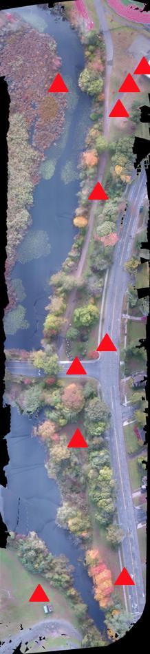
9 METHODOLOGY 2. Study area Figure. The satellite map of Beaver Pond Park ( , ), New Haven, CT The green area is approximately where we did the UAV flight mission.

 DJI Phantom 4 Quadcopter and (b) Flir DUO R dual-sensor thermal camera,")
10 METHODOLOGY 3. Instrument & flight 10 min flight in Beaver Pond Park. Synchronized visible and thermal images, 1pic/s. 440 images collected. (a) (b) Figure. The (a) DJI Phantom 4 Quadcopter and (b) Flir DUO R dual-sensor thermal camera, which has the resolution 1920 by 1080 for visible lens and 160 by 120 for thermal lens.
 JPG to 16-bit (0-65535) TIFF.")
11 METHODOLOGY 4.The workflow of Four-band Thermal Mosaicking Batch processing in MATLAB 2017b From 8-bit (0-255) JPG to 16-bit ( ) TIFF. Stretching multiplier: 10 Figure. Up-sampling the coarse thermal image and cropping the same size of edges from the visible image.


12 METHODOLOGY 4. Running SfM algorithm in Pix4D Figure. In-APP settings. Check in EXIFTOOL


13 METHODOLOGY Sparse Point Cloud Dense Point Cloud Mesh to 3D Model Orthomosaic & DSM Figure. In-APP settings.

14 METHODOLOGY 5. Results Identical pixel size Identical image dimension Identical sampled area Allows pixel-by-pixel analyses Figure. Visible orthomosaic and thermal orthomosaic
 is the themometer we used, and (b) is the visible image that has")
15 CALIBRATION 1.Radiometric calibration: synchronous measurement Figure. Synchronous measurement: (a) is the themometer we used, and (b) is the visible image that has captured the action of measurement.


16 CALIBRATION 1.Radiometric calibration: synchronous measurement Figure. Linear regression of thermometer temperature and DN value, and predicted temperature map
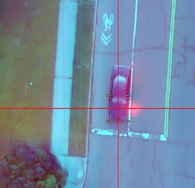
17 CALIBRATION 2.Position calibration: source of error The visible lens is about 3 cm away from the thermal lens so they actually cover different area, but we still registered the images by midline. There should be shutter delay between the lenses, although they are almost synchronized. The delay will lead to misalignment in different directions as the UAV was moving back and forth. Other misalignment due to systematic error.
 The green triangle is the FOV of visible lens represented by V, with the green arrow as its sight line.")
18 CALIBRATION 2.1. Misalignment caused by lens distance Negligible: 5 cm < 5.67 cm (pixel size) (a) (b) Figure. (a) The green triangle is the FOV of visible lens represented by V, with the green arrow as its sight line. The yellow triangle is the FOV of thermal lens represented by T, with the yellow arrow as its sight line. (b) The total misalignment of a 30 m high object on the base map.


19 2.2. Object-based calibration CALIBRATION Figure. Visualizing the object-based calibration
 The")
20 Figure. The linked view in ENVI to show the consistency of thermal orthomosaic and visible orthomosaic: (a) The misalignment before the object-based calibration. (b) The misalignment after the object-based calibration.


21 VALIDATION 1.Validating the thermal representativeness: cluster analysis Figure.13 The rule-based classification of the visible orthomosaic (left part) and the histograms of corresponding clusters (right part) in thermal band.
22 VALIDATION 1.Validating the object-based calibration (a) (c) (b)
23 CONCLUSION The Four-band Thermal Mosaicking is proved to be a reliable method to bypass the difficulty of mosaicking single-band thermal imagery. The generated thermal orthomosaic has exactly the same resolution and sampled area compared to the visible orthomosaic. Therefore, the Four-band Thermal Mosaicking make it possible to do pixel-by-pixel analysis between orthomosaics. Via cluster analysis, we validated that the temperature map can reflect the difference in thermal property. The object-based calibration is an effective method to minimize the misalignment regardless of the error source. The future work should focus on: (1) more rigorous radiometric calibration, in which the difference between emissivity of the objects should be considered. (2) quantification of the position error caused by shutter delay. (3) more solid validation of thermal representativeness.


24
USING UNMANNED AERIAL VEHICLE (DRONE/FLYCAM) TECHNOLOGY IN SURVEY WORK OF PORTCOAST
 TECHNOLOGY IN SURVEY WORK OF PORTCOAST") USING UNMANNED AERIAL VEHICLE (DRONE/FLYCAM) TECHNOLOGY IN SURVEY WORK OF PORTCOAST 1. Capturing aerial images by using Drone Taking images by drones is currently applied in many fields especially in topographic
USING UNMANNED AERIAL VEHICLE (DRONE/FLYCAM) TECHNOLOGY IN SURVEY WORK OF PORTCOAST 1. Capturing aerial images by using Drone Taking images by drones is currently applied in many fields especially in topographic
Assessing 3D Point Cloud Fidelity of UAS SfM Software Solutions Over Varying Terrain
 Assessing 3D Point Cloud Fidelity of UAS SfM Software Solutions Over Varying Terrain Michael Schwind, Michael J. Starek (Presenter) 18th Annual JALBTCX Airborne Coastal Mapping and Charting Technical Workshop,
AIRPHEN. The Multispectral camera from HIPHEN
 AIRPHEN The Multispectral camera from HIPHEN AIRPHEN is a multispectral scientific camera developed by agronomists and photonics engineers to match plant measurements needs and constraints. Its high flexibility,
Mosaicking Software: A comparison of various software suites. Geosystems Research Institute Report 5071
 Mosaicking Software: A comparison of various software suites Geosystems Research Institute Report 5071 Lee Hathcock (Mississippi State University) Ryan MacNeille (Altavian, Inc.) 3-24-2016 Mosaicking software
Simply powerful. Pix4Dmapper features the raycloud. Read more on Next generation aerial image processing software
 Next generation aerial image processing software Simply powerful Pix4D is your solution to convert thousands of aerial images taken by lightweight UAV or aircraft into georeferenced 2D mosaics and 3D surface
Getting Started with Pix4D for Agriculture 3.3
 Getting Started with Pix4D for Agriculture 3.3 Sign-up 3 Redeem 4 Hardware - Computer 4 Software Download and Installation 5 Download 5 Installation 5 Update 8 Hardware - Cameras 8 Inputs 9 Outputs 9 Image
CONTENTS. Quick Start Guide V1.0
 Quick Start Guide CONTENTS 1 Introduction... 2 2 What s in the box?... 3 3 Using your buzzard multispectral sensor... 4 3.1 Overview... 4 3.2 Connecting the power / remote trigger cable... 5 3.3 Attaching
Datasheet. Revision number: 2.1
 Datasheet Revision number: 2.1 Workswell WIRIS 2nd Generation Introduction Workswell s.r.o. is pleased to introduce you a brand new thermal imaging system Workswell WIRIS 2 nd Generation for unmanned air
Photogrammetry for forest inventory.
 Photogrammetry for forest inventory. Marc Pierrot Deseilligny. IGN/ENSG, France. Jonathan Lisein. Ulg Gembloux Agro-Bio Tech, Belgium. 1- Photogrammetry 2- Application to forestry 3- Tools and proposed
Zenmuse XT Release Notes
 2017.06.28 1. Firmware Version: v1.30.0.10 2. DJI Pilot App Android Version: v0.3.1 Added support for the Matrice 200. 1. This firmware upgrade is for the Zenmuse XT gimbal and camera only. It cannot be
SimActive and PhaseOne Workflow case study. By François Riendeau and Dr. Yuri Raizman Revision 1.0
 SimActive and PhaseOne Workflow case study By François Riendeau and Dr. Yuri Raizman Revision 1.0 Contents 1. Introduction... 2 1.1. Simactive... 2 1.2. PhaseOne Industrial... 2 2. Testing Procedure...
Sasanka Madawalagama Geoinformatics Center Asian Institute of Technology Thailand
 Sasanka Madawalagama Geoinformatics Center Asian Institute of Technology Thailand This learning material was not prepared by ADB. The views expressed in this document are the views of the author/s and
UAV s in Surveying: Integration/processes/deliverables A-Z. 3Dsurvey.si
 UAV s in Surveying: Integration/processes/deliverables A-Z Info@eGPS.net TODAY S PROGRAM Introduction to photogrammetry and 3Dsurvey Theoretical facts about the technology and basics of 3dsurvey Introduction
Rectification Algorithm for Linear Pushbroom Image of UAV
 Rectification Algorithm for Linear Pushbroom Image of UAV Ruoming SHI and Ling ZHU INTRODUCTION In recent years, unmanned aerial vehicle (UAV) has become a strong supplement and an important complement
TopoDrone Photogrammetric Mapping Reliable, Accurate, Safe
 TopoDrone Photogrammetric Mapping Reliable, Accurate, Safe A complete solution for accurate airborne data capture and photogrammetric mapping using an unmanned aerial vehicle COST EFFICIENT SOLUTION TO
WelcometotheJungle ofdigitalimagehandlingplatforms anddataproperties
 WelcometotheJungle ofdigitalimagehandlingplatforms anddataproperties A general overview with room for discussion and lots of questions By, Jesper Cairo Westergaard, Research IT Coordinator, University
Tutorial (Beginner level): Orthomosaic and DEM Generation with Agisoft PhotoScan Pro 1.3 (with Ground Control Points)
: Orthomosaic and DEM Generation with Agisoft PhotoScan Pro 1.3 (with Ground Control Points)") Tutorial (Beginner level): Orthomosaic and DEM Generation with Agisoft PhotoScan Pro 1.3 (with Ground Control Points) Overview Agisoft PhotoScan Professional allows to generate georeferenced dense point
Tutorial (Beginner level): Orthomosaic and DEM Generation with Agisoft PhotoScan Pro 1.3 (with Ground Control Points) Overview Agisoft PhotoScan Professional allows to generate georeferenced dense point
Photogrammetric Performance of an Ultra Light Weight Swinglet UAV
 Photogrammetric Performance of an Ultra Light Weight Swinglet UAV J. Vallet, F. Panissod, C. Strecha, M. Tracol UAV-g 2011 - Unmanned Aerial Vehicle in Geomatics September 14-16, 2011ETH Zurich Summary
MAPPING WITHOUT GROUND CONTROL POINTS: DOES IT WORK?
 MAPPING WITHOUT GROUND CONTROL POINTS: DOES IT WORK? BACKGROUND The economic advantages of Structure from Motion (SfM) mapping without any ground control points have motivated us to investigate an approach
Zenmuse XT Release Notes
 2018.03.30 1. Firmware Version: v1.31.0.00 2. DJI Pilot App Android Version: v0.5.1 3. DJI GO App ios Version: V3.1.30 4. DJI GO App Android Version: V3.1.28 1. Fixed an issue where users can't take photos
Tutorial (Beginner level): Orthomosaic and DEM Generation with Agisoft PhotoScan Pro 1.3 (without Ground Control Points)
: Orthomosaic and DEM Generation with Agisoft PhotoScan Pro 1.3 (without Ground Control Points)") Tutorial (Beginner level): Orthomosaic and DEM Generation with Agisoft PhotoScan Pro 1.3 (without Ground Control Points) Overview Agisoft PhotoScan Professional allows to generate georeferenced dense point
Tutorial (Beginner level): Orthomosaic and DEM Generation with Agisoft PhotoScan Pro 1.3 (without Ground Control Points) Overview Agisoft PhotoScan Professional allows to generate georeferenced dense point
Quality Report Generated with version
 Quality Report Generated with version 1.3.54 Important: Click on the different icons for: Help to analyze the results in the Quality Report Additional information about the feature Click here for additional
EnsoMOSAIC. Kopterit metsäninventointidatan keruualustoina
 EnsoMOSAIC Kopterit metsäninventointidatan keruualustoina 20.4.2017 Company introduction MosaicMill founded in 2009 EnsoMOSAIC technology since 1994 Main businesses EnsoMOSAIC forestry solutions EnsoMOSAIC
Airborne Hyperspectral Imaging Using the CASI1500
 Airborne Hyperspectral Imaging Using the CASI1500 AGRISAR/EAGLE 2006, ITRES Research CASI 1500 overview A class leading VNIR sensor with extremely sharp optics. 380 to 1050nm range 288 spectral bands ~1500
Determining the Optimum Number of Ground Control Points for Obtaining High Precision Results Based on UAS Images
 Proceedings Determining the Optimum Number of Ground Control Points for Obtaining High Precision Results Based on UAS Images Valeria-Ersilia Oniga 1, *, Ana-Ioana Breaban 2 and Florian Statescu 2 1 Department
Appendix III: Ten (10) Specialty Areas - Remote Sensing/Imagry Science Curriculum Mapping to Knowledge Units-RS/Imagry Science Specialty Area
 Specialty Areas - Remote Sensing/Imagry Science Curriculum Mapping to Knowledge Units-RS/Imagry Science Specialty Area") III. Remote Sensing/Imagery Science Specialty Area 1. Knowledge Unit title: Remote Sensing Collection Platforms A. Knowledge Unit description and objective: Understand and be familiar with remote sensing
III. Remote Sensing/Imagery Science Specialty Area 1. Knowledge Unit title: Remote Sensing Collection Platforms A. Knowledge Unit description and objective: Understand and be familiar with remote sensing
PhotoScan. Fully automated professional photogrammetric kit
 PhotoScan Fully automated professional photogrammetric kit Agisoft PhotoScan is a stand-alone photogrammetric software solution for automatic generation of dense point clouds, textured polygonal models,
Intelligent photogrammetry. Agisoft
 Intelligent photogrammetry Agisoft Agisoft Metashape is a cutting edge software solution, with its engine core driving photogrammetry to its ultimate limits, while the whole system is designed to deliver
AN INTEGRATED SENSOR ORIENTATION SYSTEM FOR AIRBORNE PHOTOGRAMMETRIC APPLICATIONS
 AN INTEGRATED SENSOR ORIENTATION SYSTEM FOR AIRBORNE PHOTOGRAMMETRIC APPLICATIONS M. J. Smith a, *, N. Kokkas a, D.W.G. Park b a Faculty of Engineering, The University of Nottingham, Innovation Park, Triumph
Accuracy Assessment of an ebee UAS Survey
 Accuracy Assessment of an ebee UAS Survey McCain McMurray, Remote Sensing Specialist mmcmurray@newfields.com July 2014 Accuracy Assessment of an ebee UAS Survey McCain McMurray Abstract The ebee unmanned
DENSE 3D POINT CLOUD GENERATION FROM UAV IMAGES FROM IMAGE MATCHING AND GLOBAL OPTIMAZATION
 DENSE 3D POINT CLOUD GENERATION FROM UAV IMAGES FROM IMAGE MATCHING AND GLOBAL OPTIMAZATION S. Rhee a, T. Kim b * a 3DLabs Co. Ltd., 100 Inharo, Namgu, Incheon, Korea ahmkun@3dlabs.co.kr b Dept. of Geoinformatic
Journal Online Jaringan COT POLIPD (JOJAPS) Accuracy Assessment of Height Coordinate Using Unmanned Aerial Vehicle Images Based On Leveling Height
 Accuracy Assessment of Height Coordinate Using Unmanned Aerial Vehicle Images Based On Leveling Height") JOJAPS eissn 2504-8457 Abstract Journal Online Jaringan COT POLIPD (JOJAPS) Accuracy Assessment of Height Coordinate Using Unmanned Aerial Vehicle Images Based On Leveling Height Syamsul Anuar Bin Abu
JOJAPS eissn 2504-8457 Abstract Journal Online Jaringan COT POLIPD (JOJAPS) Accuracy Assessment of Height Coordinate Using Unmanned Aerial Vehicle Images Based On Leveling Height Syamsul Anuar Bin Abu
Development of a Photogrammetric Processing Workflow for UAV-based Multispectral Imagery
 Development of a Photogrammetric Processing Workflow for UAV-based Multispectral Imagery Student Research Colloquium 2017 Forest Information Technology (M.Sc.) 4th Semester Max Kampen 07.05.2017 1 General
MAPPS 2013 Winter Conference 2013 Cornerstone Mapping, Inc. 1
 MAPPS 2013 Winter Conference 2013 Cornerstone Mapping, Inc. 1 What is Thermal Imaging? Infrared radiation is perceived as heat Heat is a qualitative measure of temperature Heat is the transfer of energy
P H A S E O N E I N D U S T R I A L. T h e w o r l d l e a d e r i n h i g h r e s o l u t i o n i m a g i n g
 P H A S E O N E I N D U S T R I A L T h e w o r l d l e a d e r i n h i g h r e s o l u t i o n i m a g i n g 1 WE ARE A WORLD LEADING PROVIDER of medium format digital imaging systems and solutions for
Unmanned Aerial Systems: A Look Into UAS at ODOT
 Ohio Department of Transportation John R. Kasich, Governor Jerry Wray, Director Unmanned Aerial Systems: Tim Burkholder, PS Mapping Manager Division of Engineering Office of CADD and Mapping Services Kyle
Quality Report Generated with version
 Quality Report Generated with version 3.3.67 Important: Click on the different icons for: Help to analyze the results in the Quality Report Additional information about the feature Click here for additional
Structure from Motion: High resolution DEMs at any scale using everyday equipment
 Structure from Motion: High resolution DEMs at any scale using everyday equipment Anders Damsgaard Last revision: May 20, 2014 Outline Photogrammetry Method Examples Summary Photogrammetry using SfM Production
Applications of Mobile LiDAR and UAV Sourced Photogrammetry
 Applications of Mobile LiDAR and UAV Sourced Photogrammetry Thomas J. Pingel and Earle W. Isibue Northern Illinois University 2017 Illinois GIS Association (ILGISA) Annual Meeting October 2-4, 2017 tpingel.org
ERIC SACZUK BCIT VANCOUVER, BC
 Processing UAS Photogrammetric Images in Agisoft Photoscan Professional Processing UAS Photogrammetric Images in Agisoft Photoscan Professional ERIC SACZUK BCIT VANCOUVER, BC Processing UAS Photogrammetric
Quality Report Generated with Postflight Terra 3D version
 Quality Report Generated with Postflight Terra 3D version 4.0.89 Important: Click on the different icons for: Help to analyze the results in the Quality Report Additional information about the sections
Drone2Map: an Introduction. October 2017
 Drone2Map: an Introduction October 2017 Drone2Map: An Introduction Topics: - Introduction to Drone Mapping - Coordinate Systems - Overview of Drone2Map - Basic Drone2Map Workflow - 2D Data Processing -
28 out of 28 images calibrated (100%), all images enabled. 0.02% relative difference between initial and optimized internal camera parameters
, all images enabled. 0.02% relative difference between initial and optimized internal camera parameters") Dronedata Render Server Generated Quality Report Phase 1 Time 00h:01m:56s Phase 2 Time 00h:04m:35s Phase 3 Time 00h:13m:45s Total Time All Phases 00h:20m:16s Generated with Pix4Dmapper Pro - TRIAL version
Dronedata Render Server Generated Quality Report Phase 1 Time 00h:01m:56s Phase 2 Time 00h:04m:35s Phase 3 Time 00h:13m:45s Total Time All Phases 00h:20m:16s Generated with Pix4Dmapper Pro - TRIAL version
LEAK DETECTION UTILIZING SMALL UNMANNED AERIAL SYSTEMS (SUAS) PRESENTED BY MATT HALKER
 PRESENTED BY MATT HALKER") LEAK DETECTION UTILIZING SMALL UNMANNED AERIAL SYSTEMS (SUAS) PRESENTED BY MATT HALKER of Agenda Introduction Who we are Why we need leak detection Traditional methods of inspection Benefits of suas inspection
LEAK DETECTION UTILIZING SMALL UNMANNED AERIAL SYSTEMS (SUAS) PRESENTED BY MATT HALKER of Agenda Introduction Who we are Why we need leak detection Traditional methods of inspection Benefits of suas inspection
GEOBIA for ArcGIS (presentation) Jacek Urbanski
 Jacek Urbanski") GEOBIA for ArcGIS (presentation) Jacek Urbanski INTEGRATION OF GEOBIA WITH GIS FOR SEMI-AUTOMATIC LAND COVER MAPPING FROM LANDSAT 8 IMAGERY Presented at 5th GEOBIA conference 21 24 May in Thessaloniki.
GEOBIA for ArcGIS (presentation) Jacek Urbanski INTEGRATION OF GEOBIA WITH GIS FOR SEMI-AUTOMATIC LAND COVER MAPPING FROM LANDSAT 8 IMAGERY Presented at 5th GEOBIA conference 21 24 May in Thessaloniki.
EVOLUTION OF POINT CLOUD
 Figure 1: Left and right images of a stereo pair and the disparity map (right) showing the differences of each pixel in the right and left image. (source: https://stackoverflow.com/questions/17607312/difference-between-disparity-map-and-disparity-image-in-stereo-matching)
THREE DIMENSIONAL CURVE HALL RECONSTRUCTION USING SEMI-AUTOMATIC UAV
 THREE DIMENSIONAL CURVE HALL RECONSTRUCTION USING SEMI-AUTOMATIC UAV Muhammad Norazam Zulgafli 1 and Khairul Nizam Tahar 1,2 1 Centre of Studies for Surveying Science and Geomatics, Faculty of Architecture
Quality Report Generated with Pro version
 Quality Report Generated with Pro version 2.1.61 Important: Click on the different icons for: Help to analyze the results in the Quality Report Additional information about the sections Click here for
Multiview Photogrammetry 3D Virtual Geology for everyone
 Multiview Photogrammetry 3D Virtual Geology for everyone A short course Marko Vrabec University of Ljubljana, Department of Geology FIRST: some background info Precarious structural measurements of fractures
Drone2Map for ArcGIS: Bring Drone Imagery into ArcGIS
 Drone2Map for ArcGIS: Bring Drone Imagery into ArcGIS Mike Sweeney 1 Drone2Map for ArcGIS Turn Drones into Enterprise Productivity Tools ArcGIS Drone2Map for ArcGIS Create 2D and 3D products from raw drone
Laptop Generated Quality Report Phase 1 Time 00h:26m:45s Phase 2 Time 02h:30m:06s Phase 3 Time 01h:20m:19s Total Time All phases 04h:17m:10s
 Laptop Generated Quality Report Phase 1 Time 00h:26m:45s Phase 2 Time 02h:30m:06s Phase 3 Time 01h:20m:19s Total Time All phases 04h:17m:10s Generated with Pix4Dmapper Pro - TRIAL version 2.0.104 Important:
Development of Unmanned Aircraft System (UAS) for Agricultural Applications. Quarterly Progress Report
 for Agricultural Applications. Quarterly Progress Report") Development of Unmanned Aircraft System (UAS) for Agricultural Applications Quarterly Progress Report Reporting Period: October December 2016 January 30, 2017 Prepared by: Lynn Fenstermaker and Jayson
Development of Unmanned Aircraft System (UAS) for Agricultural Applications Quarterly Progress Report Reporting Period: October December 2016 January 30, 2017 Prepared by: Lynn Fenstermaker and Jayson
Best Practices for Managing Aerial and UAS Frame Imagery. Cody Benkelman, Jie Zhang
 Best Practices for Managing Aerial and UAS Frame Imagery Cody Benkelman, Jie Zhang Objectives Manage and share collections of imagery from aerial frame cameras - Professional digital cameras - Metric lens,
UAS Campus Survey Project
 ARTICLE STUDENTS CAPTURING SPATIAL INFORMATION NEEDS UAS Campus Survey Project Texas A&M University- Corpus Christi, home to the largest geomatics undergraduate programme in Texas, USA, is currently undergoing
Paris-Le Bourget Airport. 557 out of 557 images calibrated (100%), all images enabled
, all images enabled") DroneData Render Server Generated Quality Report Phase 1 Time 00h:27m:34s Phase 2 Time 01h:40m:23s Phase 3 Time 01h:41m:18s Total Time All Phases 03h:48m:59s Generated with Pix4Dmapper Pro - TRIAL version
DroneData Render Server Generated Quality Report Phase 1 Time 00h:27m:34s Phase 2 Time 01h:40m:23s Phase 3 Time 01h:41m:18s Total Time All Phases 03h:48m:59s Generated with Pix4Dmapper Pro - TRIAL version
Digital Photogrammetry Software Comparison for Rock Mass Characterization
 ARMA 18 1211 Digital Photogrammetry Software Comparison for Rock Mass Characterization Becker, R.E., Galayda, L.J., MacLaughlin, M.M. Montana Tech, Butte, Montana, USA Copyright 2018 ARMA, American Rock
Camera Drones Lecture 3 3D data generation
 Camera Drones Lecture 3 3D data generation Ass.Prof. Friedrich Fraundorfer WS 2017 Outline SfM introduction SfM concept Feature matching Camera pose estimation Bundle adjustment Dense matching Data products
PhotoScan. Fully automated professional photogrammetric kit
 PhotoScan Fully automated professional photogrammetric kit Agisoft PhotoScan is a stand-alone photogrammetric software solution for automatic generation of dense point clouds, textured polygonal models,
Tutorial (Intermediate level): Dense Cloud Classification and DTM generation with Agisoft PhotoScan Pro 1.1
: Dense Cloud Classification and DTM generation with Agisoft PhotoScan Pro 1.1") Tutorial (Intermediate level): Dense Cloud Classification and DTM generation with Agisoft PhotoScan Pro 1.1 This tutorial illustrates how to perform dense point cloud classification in manual and automatic
Tutorial (Intermediate level): Dense Cloud Classification and DTM generation with Agisoft PhotoScan Pro 1.1 This tutorial illustrates how to perform dense point cloud classification in manual and automatic
Accuracy Assessment of POS AVX 210 integrated with the Phase One ixu150
 White Paper 3/17/2016 Accuracy Assessment of POS AVX 210 integrated with the Phase One ixu150 Omer Mian, Joe Hutton, Greg Lipa, James Lutes, Damir Gumerov, Srdjan Sobol Applanix, William Chan - GeoPixel
New! Analysis Ready Data Tools Add-on package for image preprocessing for multi-temporal analysis. Example of satellite imagery time series of Canada
 Highlights New! Analysis Ready Data Tools Add-on package for image preprocessing for multi-temporal analysis Rigorous scientific preprocessing Example of satellite imagery time series of Canada A new industry
Feel4U TerrEye. Tactical decision-support solutions for land management (for a better and cost-efficiency & environmental friendly land stewardship)
") Feel4U TerrEye Tactical decision-support solutions for land management (for a better and cost-efficiency & environmental friendly land stewardship) Guillaume Janssens Agro-Environment Consultant info@terreye.com
Feel4U TerrEye Tactical decision-support solutions for land management (for a better and cost-efficiency & environmental friendly land stewardship) Guillaume Janssens Agro-Environment Consultant info@terreye.com
Introduction. Acute3D S.A.S. WTC Valbonne Sophia Antipolis. 120 route des Macarons.
 Introduction This benchmark compares the performances of the three main photo-based 3Dmodeling software. Five projects related to different kind of applications were led on the same machine and this document
MASI: Modules for Aerial and Satellite Imagery
 MASI: Modules for Aerial and Satellite Imagery Product Descriptions and Typical Applied Cases Dr. Jinghui Yang jhyang@vip.163.com Sept. 18, 2017 File Version: v1.0 VisionOnSky Co., Ltd. Contents 1 Descriptions
Tutorial (Intermediate Level): Radiometric calibration using reflectance panels in PhotoScan Professional 1.4
: Radiometric calibration using reflectance panels in PhotoScan Professional 1.4") Tutorial (Intermediate Level): Radiometric calibration using reflectance panels in PhotoScan Professional 1.4 This tutorial describes common workflow related to the reflectance calibration of multispectral
Tutorial (Intermediate Level): Radiometric calibration using reflectance panels in PhotoScan Professional 1.4 This tutorial describes common workflow related to the reflectance calibration of multispectral
2. POINT CLOUD DATA PROCESSING
 Point Cloud Generation from suas-mounted iphone Imagery: Performance Analysis A. D. Ladai, J. Miller Towill, Inc., 2300 Clayton Road, Suite 1200, Concord, CA 94520-2176, USA - (andras.ladai, jeffrey.miller)@towill.com
Trimble Geospatial Division Integrated Solutions for Geomatics professions. Volker Zirn Regional Sales Representative
 Trimble Geospatial Division Integrated Solutions for Geomatics professions Volker Zirn Regional Sales Representative 1 Agenda Trimble GeoSpatial Division Airborne System Solutions Trimble Inpho Software
UAV Flight Operations for Mapping. Precision. Accuracy. Reliability
 UAV Flight Operations for Mapping Precision. Accuracy. Reliability Part One: Why is Mapping different? Part Two: What about accuracy and precision? Part Three: What is the Workflow? Part Four: AGENDA What
A Guide to Processing Photos into 3D Models Using Agisoft PhotoScan
 A Guide to Processing Photos into 3D Models Using Agisoft PhotoScan Samantha T. Porter University of Minnesota, Twin Cities Fall 2015 Index 1) Automatically masking a black background / Importing Images.
Reality Modeling Drone Capture Guide
 Reality Modeling Drone Capture Guide Discover the best practices for photo acquisition-leveraging drones to create 3D reality models with ContextCapture, Bentley s reality modeling software. Learn the
Best Practices for Managing Processed Ortho Imagery
 Best Practices for Managing Processed Ortho Imagery Cody Benkelman DRAFT slides (June 2017) Characteristics of Processed Ortho Imagery Typically 8 bit (sometimes 16) Typically 3 spectral bands (sometimes
The 2014 IEEE GRSS Data Fusion Contest
 The 2014 IEEE GRSS Data Fusion Contest Description of the datasets Presented to Image Analysis and Data Fusion Technical Committee IEEE Geoscience and Remote Sensing Society (GRSS) February 17 th, 2014
Efficient Processing of UAV Projects
 Efficient Processing of UAV Projects Dr. Philippe Simard President SimActive Inc. IMAGE About SimActive Leading developer of photogrammetry software since 2003 Thousands of users in 50+ countries: military
2/9/2016. Session Agenda: Implementing new Geospatial Technologies for more efficient data capture
 Implementing new Geospatial Technologies for more efficient data capture Jay Haskamp Applied Geospatial Engineer Steve Richter VP Sales Session Agenda: Today s changing technologies and what lies ahead
Mapping Road surface condition using Unmanned Aerial Vehicle- Based Imaging System. Ahmed F. Elaksher St. Cloud State University
 Mapping Road surface condition using Unmanned Aerial Vehicle- Based Imaging System Ahmed F. Elaksher St. Cloud State University 1 Outline Introduction & Motivation Methodology Experimental Results & Analysis
Airborne LiDAR Data Acquisition for Forestry Applications. Mischa Hey WSI (Corvallis, OR)
") Airborne LiDAR Data Acquisition for Forestry Applications Mischa Hey WSI (Corvallis, OR) WSI Services Corvallis, OR Airborne Mapping: Light Detection and Ranging (LiDAR) Thermal Infrared Imagery 4-Band
Airborne LiDAR Data Acquisition for Forestry Applications Mischa Hey WSI (Corvallis, OR) WSI Services Corvallis, OR Airborne Mapping: Light Detection and Ranging (LiDAR) Thermal Infrared Imagery 4-Band
REMOTE SENSING LiDAR & PHOTOGRAMMETRY 19 May 2017
 REMOTE SENSING LiDAR & PHOTOGRAMMETRY 19 May 2017 SERVICES Visual Inspections Digital Terrain Models Aerial Imagery Volume Computations Thermal Inspections Photo maps Aerial Video Training & Consultancy
The ArcGIS Platform for Managing, Processing, and Sharing UAV Data
 The ArcGIS Platform for Managing, Processing, and Sharing UAV Data Cody Benkelman, Technical Product Manager - Imagery David Gadsden, Nonprofit Program Manager Esri Advancing GIS Strong and Growing..Serving
Dense DSM Generation Using the GPU
 Photogrammetric Week '13 Dieter Fritsch (Ed.) Wichmann/VDE Verlag, Belin & Offenbach, 2013 Rotenberg et al. 285 Dense DSM Generation Using the GPU KIRILL ROTENBERG, LOUIS SIMARD, PHILIPPE SIMARD, Montreal
Digital Photogrammetric System. Version 5.3 USER GUIDE. Processing of UAV data
 Digital Photogrammetric System Version 5.3 USER GUIDE Table of Contents 1. Workflow of UAV data processing in the system... 3 2. Create project... 3 3. Block forming... 5 4. Interior orientation... 6 5.
Geothermal Field Work Using a Drone With Thermal Camera: Aerial Photos, Digital Elevation Models and Heat Flow
 GRC Transactions, Vol. 40, 2016 Geothermal Field Work Using a Drone With Thermal Camera: Aerial Photos, Digital Elevation Models and Heat Flow M. C. Harvey School of Environment, University of Auckland,
Piksi for UAV Aerial Surveying. RTK Direct Georeferencing with Swift Navigation s Piksi GPS Receiver
 Piksi for UAV Aerial Surveying RTK Direct Georeferencing with Swift Navigation s Piksi GPS Receiver Dennis Zollo, Rai Gohalwar Version 0.1, March 29, 2016 Contents 1.0 Abstract 2 2.0 Overview 3 3.0 Equipment
The Use of UAS in modern field work
 The Use of UAS in modern field work SplitRS 2015, Thessaloniki, GREECE 22/05/2015 1 ebee by sensefly Swiss-made UAV Fully autonomous flight Suitable for: Mapping, GIS, Surveying Precision Agriculture Environmental
(Subsea) Keith Vickery Zupt LLC
 Keith Vickery Zupt LLC") (Subsea) Keith Vickery Zupt LLC kv@zupt.com Offshore subsea infrastructure surveys (pipeline inspection, well, XT, and manifold inspections) are required to ensure compliance with both internal operator,
(Subsea) Keith Vickery Zupt LLC kv@zupt.com Offshore subsea infrastructure surveys (pipeline inspection, well, XT, and manifold inspections) are required to ensure compliance with both internal operator,
A New Protocol of CSI For The Royal Canadian Mounted Police
 A New Protocol of CSI For The Royal Canadian Mounted Police I. Introduction The Royal Canadian Mounted Police started using Unmanned Aerial Vehicles to help them with their work on collision and crime
The raycloud A Vision Beyond the Point Cloud
 The raycloud A Vision Beyond the Point Cloud Christoph STRECHA, Switzerland Key words: Photogrammetry, Aerial triangulation, Multi-view stereo, 3D vectorisation, Bundle Block Adjustment SUMMARY Measuring
Quality Report Generated with Pix4Dmapper Pro version
 Quality Report Generated with Pix4Dmapper Pro version 3.1.23 Important: Click on the different icons for: Help to analyze the results in the Quality Report Additional information about the sections Click
Aerial Mapping using UAS. Jeff Campbell
 Aerial Mapping using UAS Jeff Campbell 1 Agenda 1. Introduction 2. UAS Mapping Explained 3. Use Cases / Outputs 4. Technologies 5. Training Methods 6. Implementation Strategies 7. Emerging Technologies
Drone2Map for ArcGIS: Bring Drone Imagery into ArcGIS. Will
 Drone2Map for ArcGIS: Bring Drone Imagery into ArcGIS Will Meyers @MeyersMaps A New Window on the World Personal Mapping for Micro-Geographies Accurate High Quality Simple Low-Cost Drone2Map for ArcGIS
THE ISPRS/EUROSDR BENCHMARK ON MULTI-PLATFORM PHOTOGRAMMETRY: RESULTS AND LESSON LEARNT FRANCESCO NEX AND MARKUS GERKE
 THE ISPRS/EUROSDR BENCHMARK ON MULTI-PLATFORM PHOTOGRAMMETRY: RESULTS AND LESSON LEARNT FRANCESCO NEX AND MARKUS GERKE Overview Summary of the results Statistics Data release What s next? ISPRS / EuroSDR
POSITIONING A PIXEL IN A COORDINATE SYSTEM
 GEOREFERENCING AND GEOCODING EARTH OBSERVATION IMAGES GABRIEL PARODI STUDY MATERIAL: PRINCIPLES OF REMOTE SENSING AN INTRODUCTORY TEXTBOOK CHAPTER 6 POSITIONING A PIXEL IN A COORDINATE SYSTEM The essential
Fluke Ti40FT and Ti45FT IR FlexCam Thermal Imagers with IR-Fusion Technology
 Thermal Imaging Fluke Ti40FT and Ti45FT IR FlexCam Thermal Imagers with IR-Fusion Technology The versatile choice for maintenance and production engineers and technicians The Fluke Ti4x models feature
Virtual and remote inspection methods
 Virtual and remote inspection methods Rasmus Lindeneg Johansen, RLJ@cowi.dk 1 How do we inspect "today"? 2 Inspection "today" Manual inspections From the ground From lift/platform By rope Data was collected
Structure from Motion (SfM) Photogrammetry Data Exploration and Processing Manual
 Photogrammetry Data Exploration and Processing Manual") Structure from Motion (SfM) Photogrammetry Data Exploration and Processing Manual Written by Katherine Shervais (UNAVCO) and James Dietrich (Dartmouth) Collecting data in the field is only the first step
Structure from Motion (SfM) Photogrammetry Data Exploration and Processing Manual Written by Katherine Shervais (UNAVCO) and James Dietrich (Dartmouth) Collecting data in the field is only the first step
Scalability for Large Photogrammetry Projects
 Scalability for Large Photogrammetry Projects Dr. Philippe Simard President SimActive Inc. IMAGE About SimActive Founded in 2003, SimActive is the developer of Correlator3D software, a patented end-to-end
Near-Infrared Dataset. 101 out of 101 images calibrated (100%), all images enabled
, all images enabled") Dronedata Back Office Server Generated Quality Report Phase 1 Time 01h:22m:16s Phase 2 Time 00h:11m:39s Phase 3 Time 00h:01m:40s Total Time All Phases 01:35m:35s Generated with Pix4Dmapper Pro - TRIAL
Dronedata Back Office Server Generated Quality Report Phase 1 Time 01h:22m:16s Phase 2 Time 00h:11m:39s Phase 3 Time 00h:01m:40s Total Time All Phases 01:35m:35s Generated with Pix4Dmapper Pro - TRIAL
Introduction to photogrammetry (with an underwater flavor)
") Introduction to photogrammetry (with an underwater flavor) NAS - UCY HFF Field school, Cyprus, 2016 Dimitrios Skarlatos, Assistant Professor, Cyprus University of Technology Photogrammetric vision Lab
Introduction to photogrammetry (with an underwater flavor) NAS - UCY HFF Field school, Cyprus, 2016 Dimitrios Skarlatos, Assistant Professor, Cyprus University of Technology Photogrammetric vision Lab
Presented at the FIG Congress 2018, May 6-11, 2018 in Istanbul, Turkey
 Presented at the FIG Congress 2018, May 6-11, 2018 in Istanbul, Turkey Evangelos MALTEZOS, Charalabos IOANNIDIS, Anastasios DOULAMIS and Nikolaos DOULAMIS Laboratory of Photogrammetry, School of Rural
proctool_owl_v2.1 AisaOWL pre-processing tool quick operation instructions
 proctool_owl_v2.1 AisaOWL pre-processing tool quick operation instructions Doc.Ver. 1.1 30.05. 2014 / Hannu Holma, Specim System requirements Operating system: 64 bit Windows Installation 1. Run Matlab
P h a s e O n e i X U - RS A c c u r a c y A n a l y s i s. T h e f o r e f r o n t o f a e r i a l p h o t o g r a p h y
 P h a s e O n e i X U - RS1 0 0 0 A c c u r a c y A n a l y s i s T h e f o r e f r o n t o f a e r i a l p h o t o g r a p h y 1 Phase One Industrial Aerial Survey Products ixu-rs1000, ixu1000 series