ENHANCED DELIVERABLES AND THE DIGITAL JOBSITE NOVEMBER 14, 2018
|
|
|
- Augustine Howard
- 5 years ago
- Views:
Transcription

1 ENHANCED DELIVERABLES AND THE DIGITAL JOBSITE NOVEMBER 14, 2018

2 Background CP Tech Center/Snyder & Associates team EDC-2 3D Engineered Models EDC-4 e-construction (Digital Construction Inspection) 2
3 What is a 3D Engineered Model 3D Engineered Model: A digital graphical representation of proposed facility/site data consisting of x, y, and z coordinates for producing objects in three-dimensions to communicate design intent useful for visualization, analysis, animation, simulation, plans, specifications, estimates production, and life-cycle asset management. 3

4 What is a 3D Engineered Model Surfaces Existing/Proposed Utilities Structures Time Cost 4

5 Benefits of 3D Engineered Models Increased efficiency Early detection of issues Facilitates stakeholder buy-in Improves communication Models for presentation 5
6 Why should you care? Benefits to Owners/Designers Increased Efficiency More Accurate Quantity Takeoffs Visualization Capabilities Enhanced Quality Assurance in Design Data Streamlining/Enhanced Deliverables 6

7 Increased Efficiency NO! Not less time designing More Time More design iterations can be examined 2D Plans are the result of a 3D Model 7


8 Accurate Quantity Takeoffs Surface to Surface Comparisons Optimize Overlay Quantities 9-Line Profiles Mobile/Static Scanning 8

9 Visualization Capabilities 9

10 Enhanced Quality Assurance in Design 3D and Drivethrough views Clash Detection Clearance Measurements


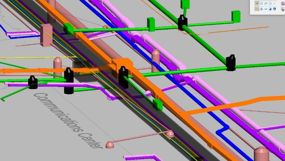
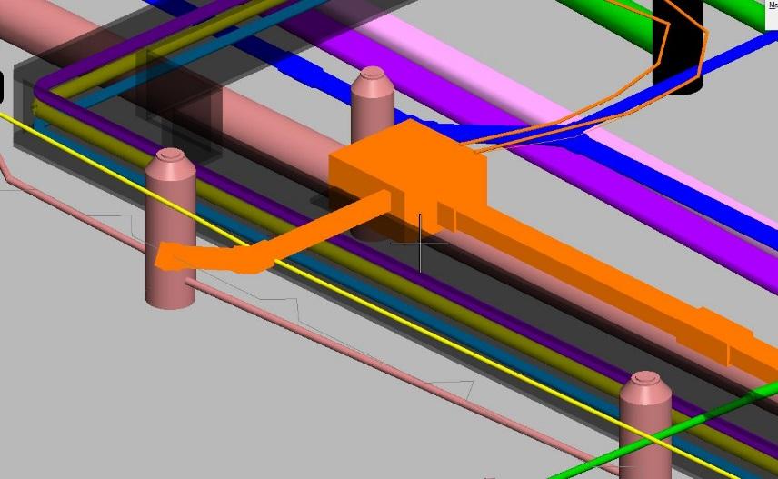
11 Enhanced Quality Assurance in Design


12 Data Streamlining From Designer to Contractor Introduces Fewer Chances for Error

13 CAD Standards Level/Layer File names File Naming Alignments Templates Point Controls 13
14 Data Transfer Universal Data Types are key! Proprietary data types are only good when both parties are using the same software typically not the case CADD files = DXF 2D linework (i.e. Boundary/ROW) 3D linework (i.e. Roadway section breaklines, terrain breaklines) 3D modeled solids (i.e. Bridge abutments, piers, piles, girders, etc.) Alignments and Surfaces = XML Horizontal Alignments and Profiles Digital Terrain Models (DTMs), Triangulated Irregular Networks (TINs), etc) LiDAR Data = E57 Aerial LiDAR Terrestrial LiDAR Mobile LiDAR 14
15 Electronic File Needs For Machine Control Grading o Surface (Triangular Irregular Network) o o Linework File (Horizontal Only) File Types XML s or.dxf s For Machine Control Paving, Milling, Trimming o 3D Polylines XML s or DXF s o o Alignment XML s Transition Locations (Supers) 15

16 AMG Paving - Setup 16

17 AMG Paving - Inputs 17
18 Survey Needs Tie In shots verified Tight Horizontal and Vertical Control Control points every 500 on each side of road staggered 18
19 Digital Construction Inspection Designer s role should continue into construction Designer reviewing contractor s model Who is creating the model of record? Handling Changes in Construction How much of a surveyor will our construction inspectors have to become? 19
20 Contractor Work Plan 20
21 How Much Survey in Construction? Field Calibration of Model and Survey Data Collection Selecting the Right Tool Hardware and Software Skills Greater Integration of Workflows with Design 21

22 GPS Rovers FHWA vision Every Inspector has one of these Courtesy Oregon DOT 22
23 Uses Checking Grade (subgrade) Measuring Quantities (linear, area) Check Station/Offset Positioning Site Mapping Utility Locates/Conflict Documentation Utility Asbuilts 23


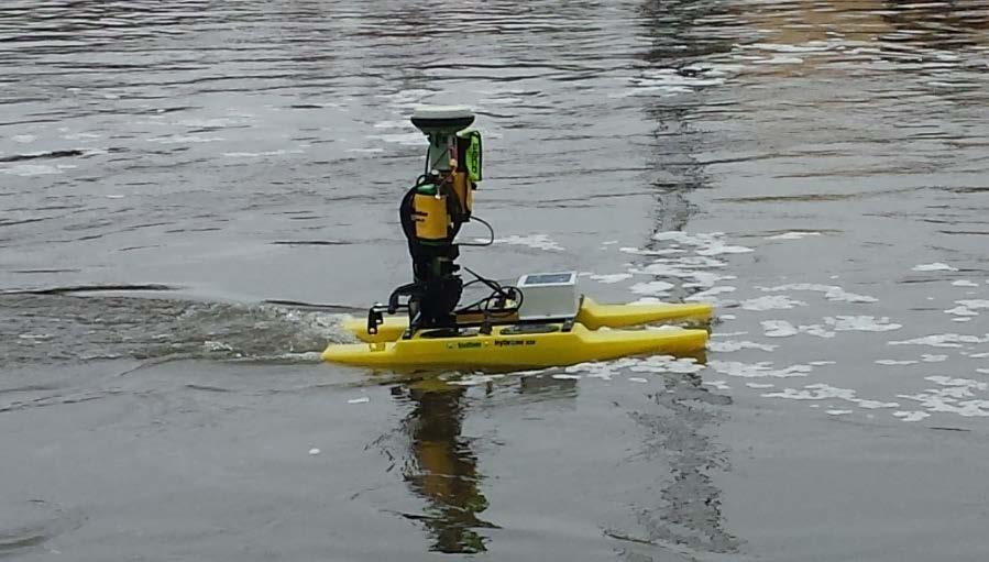
24 Other Tools Total Stations LiDAR HyDrone UAS 24

25 All tools are not created equal 25

26 Contact Information Gabriel Nelson, P.E. Civil Engineer 26
3-D Modeling Implementation
 3-D Modeling Implementation Presented January 31, 2013 Douglas Townes FHWA Resource Center WORKFLOW FOR ELECTRONIC DATA TRANSFER WHEN USING AMG IN CONSTRUCTION Charles Jahren, PhD Iowa State University
Delivering 3D Engineered Model Data for Highway Construction
 Delivering 3D Engineered Model Data for Highway Construction Objectives After completing this module, you will be able to: Describe how 3D engineered models are created in design Describe how contractors
MoDOT s 3D Design Implementation, Electronic Deliverables, and E-Construction. Ashley Buechter, P.E. MoDOT CADD Support Engineer
 MoDOT s 3D Design Implementation, Electronic Deliverables, and E-Construction Ashley Buechter, P.E. MoDOT CADD Support Engineer LADOTD Transportation Conference February 29, 2016 General Information and
5/17/2017. Steven Popke, PE Wisconsin DOT Bureau of Project Development Methods Development Unit
 Steven Popke, PE Wisconsin DOT Bureau of Project Development Unit Wisconsin Department of Transportation since 2014 Assists with WisDOT spilot program for sharing design model data with construction contractors
Business Advantages of Using Electronic Engineering Data
 Business Advantages of Using Electronic Engineering Data Dan Streett, PE & LS NYS Department of Transportation December 5, 2006 AGC/DOT Technical Conference Types of Electronic Engineering Data Created
DTFH61-13-C Addressing Challenges for Automation in Highway Construction
 DTFH61-13-C-00026 Addressing Challenges for Automation in Highway Construction Learning Objectives Research Objectives Research Team Introduce Part I: Implementation Challenges and Success Stories Describe
3-D MODELING FOR MACHINE CONTROL
 SHELLY & SANDS JOHN DOWALTER, PE, PS 3-D MODELING FOR MACHINE CONTROL Dale Carnegie Public Speaking Training Ben Stein s Public Speaking Training SHELLY & SANDS JOHN DOWALTER, PE, PS S&S Survey Manager
Trimble Business Center Software, v3.30
 Trimble Business Center Software, v3.30 We are pleased to announce a new version of the Trimble Business Center software, version 3.30. This new version includes over 30 new features and enhancements increasing
3D Technology in the Construction Continuum. Alabama DOT Pre-Construction Conference Montgomery AL May 03, 2016
 3D Technology in the Construction Continuum Alabama DOT Pre-Construction Conference Montgomery AL May 03, 2016 Brian E Girouard, Sales Engineer, Milling-Paving-Compaction Specialist Civil Engineering &
Overview September 7, 2017
 Overview September 7, 2017 Purpose The purpose of this presentation is to provide an overview of the changes to the required deliverables and workflow for developing plans and models for Illinois DOT projects
Trimble SCS900 Site Controller Software for Beginners. Jordan Lawver HCC-6339
 Trimble SCS900 Site Controller Software for Beginners Jordan Lawver HCC-6339 Agenda What is Trimble SCS900 Site Controller Software? Who uses SCS900 Trimble Site Positioning System software portfolio Applications
2/9/2016. Session Agenda: Implementing new Geospatial Technologies for more efficient data capture
 Implementing new Geospatial Technologies for more efficient data capture Jay Haskamp Applied Geospatial Engineer Steve Richter VP Sales Session Agenda: Today s changing technologies and what lies ahead
Bentleyuser.dk Årsmøde 2012 Nordic Civil 2012
 Bentleyuser.dk Årsmøde 2012 Nordic Civil 2012 5.-7. November 2012, Munkebjerg Hotel, Vejle Workshop X7 Civil Design Review: 3D Modeling and Team Leader: Joe Waxmonsky, PE Bentley Systems, Incorporated
ODOT s Future with 3D Models
 Ohio Department of Transportation Mark McCloud, CADD Manager, CADD and Mapping Services October 28 th, 2015 John R. Kasich, Governor Jerry Wray, Director www.transportation.ohio.gov FHWA Every Day Counts
Session Objectives. Describe how 3D Models are created during design. Discuss what 3D Model outputs are useful in Construction
 1 Session Objectives Describe how 3D Models are created during design Discuss what 3D Model outputs are useful in Construction Describe applications of 3D Models in Construction 2 Creating the 3D Design
Quality Assurance and Quality Control Procedures for Survey-Grade Mobile Mapping Systems
 Quality Assurance and Quality Control Procedures for Survey-Grade Mobile Mapping Systems Latin America Geospatial Forum November, 2015 Agenda 1. Who is Teledyne Optech 2. The Lynx Mobile Mapper 3. Mobile
Table of Contents. MDOT - Creating Model Line String and LandXML RID Files
 Table of Contents General Information... 2 Part 1: Proposed Terrain Model Creation... 3 Option 1: Element Selection Method... 3 Proposed Top Surface... 3 Proposed Subsurface... 4 Option 2: Terrain from
Quality Control Checklist & Tools for Reviewing 3D Engineered Models
 Quality Control Checklist & Tools for Reviewing 3D Engineered Models Production Support Office CADD Vern Danforth Description: In this session we will discuss 3D engineered models. Brief FDOT CADD/Industry
Landfill Grading Using GPS Machine Control
 Landfill Grading Using GPS Machine Control NC SWANA April 2018 Presented by: Bernie Garrett, PE Garrett & Moore Inc. & Gabe Leach Cooper Barnette & Page Inc. 1 Purpose Work flow processes used by Engineers,
Licensed Features - Trimble Business Center v3.10
 Licensed Features - Trimble Business Center v3.10 The following table lists the features available in Trimble Business Center based on the installed. Feature No License Base Complete Advanced Photogrammetry
Innovation. lidarnews.com. volume 3 issue 5. Points clouds and terrain models support rail project. Structured light scanning for human head modeling
 volume 3 issue 5 LIDAR lidarnews.com SCALABILITY Points clouds and terrain models support rail project EXPRESSION Structured light scanning for human head modeling FLUCTUATION Scanning moving objects using
LandXML.org 2.0. a Data Exchange Standard. for. Nathan Crews, Principal Schema Architect, LandXML.org
 LandXML.org 2.0 a Data Exchange Standard for eplan LandXML Deliverable Nathan Crews, Principal Schema Architect, LandXML.org Outline LandXML.org 1999 Autodesk supported effort LandXML Standard Adoption
3D Design Overview.
 3D Design Overview vern.danforth@dot.state.fl.us Typical Plans Set 2D Plans 2D Design Plans History: Why create 2D Plans? FDOT Contract requirements Engineer s sign and seal paper for accountability Provide
Pave the Way to Better Profits. Trimble. Paving Solutions TRANSFORMING THE WAY THE WORLD WORKS
 Pave the Way to Better Profits Trimble Paving Solutions TRANSFORMING THE WAY THE WORLD WORKS Solutions for the Complete Paving Job Site Productive, integrated and innovative solutions to keep you on track
Section 7 - Introducing Roadway Modeling
 Introducing Roadway Modeling Section 7 - Introducing Roadway Modeling Section Goals: Understand the Principles of InRoads Roadway Modeling Understand how to load Typical Section Libraries Understand how
General GPS TPS ROB X POLE VOL RDN RPL Jobs management System settings (units, precision, parameters, etc.)
") XPAD Survey Modules XPAD Survey GPS TPS XPOLE General GPS TPS ROB XPOLE VOL RDN RPL Jobs management System settings (units, precision, parameters, etc.) Instruments GPS GPS TPS ROB XPOLE VOL RDN RPL Instrument
XPAD Survey Modules XPAD Survey GPS TPS XPOLE General GPS TPS ROB XPOLE VOL RDN RPL Jobs management System settings (units, precision, parameters, etc.) Instruments GPS GPS TPS ROB XPOLE VOL RDN RPL Instrument
TECHNICAL NOTES SURVEY PRO WITH TSX
 SURVEY PRO WITH TSX TECHNICAL NOTES Survey Pro software from TDS is the data collection solution of choice for most North American surveyors 1. And with the addition of the Trimble TSX (Trimble Systems
Chapter 1: Introducing Roadway Modeling
 Introducing Roadway Modeling Chapter 1: Introducing Roadway Modeling Chapter Overview The chapter addresses the following topics: How Roadway Modeling Works in InRoads Opening and Exploring Typical Section
GeoSmart Asia Locate 18
 MOBILE MAPPING GeoSmart Asia Locate 18 ESP Associates, P.A. ESP Associates, P.A. ABOUT ESP Founded in 1986 (28 Years of Experience with DOT s) ESP has 14 offices throughout the US 37 States, Canada, and
Roadway Design using GeoTools
 Roadway Design using GeoTools Introduction GeoTools is a general-purpose productivity tool for users of all types of geographic data. In the Civil Tools section, there are many tools for Civil engineering
Surfaces - Objectives
 Surfaces - Objectives Cover the Basic DTM Point Types Creating a new InRoads Surface Surface processing in InRoads Loading 3D data into a Surface A bit about Surface Properties Overview of the View Surface
Aerial and Mobile LiDAR Data Fusion
 Creating Value Delivering Solutions Aerial and Mobile LiDAR Data Fusion Dr. Srini Dharmapuri, CP, PMP What You Will Learn About LiDAR Fusion Mobile and Aerial LiDAR Technology Components & Parameters Project
Figure 1: Mobile mapping project location in New York City.
 Using Mobile LiDAR to Deliver Survey Accurate Data This presentation will take the attendees though the process of controlling and delivering survey grade LiDAR data for use in CADD, Modeling, and GIS
Microwave. Infrared. Preprogrammed Chip
 Advanced Technology for Design Mapping and Construction Layout AACE A.A.C.E. Meeting August 5, 2009 Daniel K. Mardock RBF Consulting Survey Manager Registered Land Surveyor Certified Federal Surveyor Arizona
Features and Benefits
 CAiCE Visual Survey 10 Features and Benefits CAiCE Visual Survey 10 software enables surveying professionals to import, process, analyze, and present surveying all in one software package. Visual Survey
The complete design environment for road planning & construction ANADELTA TESSERA.
 The complete design environment for road planning & construction Short Description Short Description ANADELTA TESSERA Tessera is the professional, standards-based road design solution helping civil engineers
Merging LiDAR Data with Softcopy Photogrammetry Data
 Merging LiDAR Data with Softcopy Photogrammetry Data Cindy McCallum WisDOT\Bureau of Technical Services Surveying & Mapping Section Photogrammetry Unit Overview Terms and processes Why use data from LiDAR
Hexagon 2012 Think Forward! Session ID Using Point Cloud Data Directly for Civil Design of Airport Infrastructure
 Hexagon 2012 Think Forward! Session ID 9113 - Using Point Cloud Data Directly for Civil Design of Airport Infrastructure INTRODUCTION & BACKGROUND Mark D. McGuire, P.E., Sr. Vice President for Campbell
Mobile Mapping Solutions for Ohio s Integrated Transportation Network. Brian Foster, CP
 Mobile Mapping Solutions for Ohio s Integrated Transportation Network Brian Foster, CP About Woolpert Established in 1911 Over 600 Professionals 25 Offices $12,000,000 invested in new technology in last
Title: Improving Your InRoads DTM. Mats Dahlberg Consultant Civil
 Title: Improving Your InRoads DTM Mats Dahlberg Consultant Civil Improving Your InRoads Digital Terrain Model (DTM) Digital Terrain Model A digital representation of a surface topography or terrain composed
Autodesk Civil 3D Fundamentals
 Autodesk Civil 3D Fundamentals Course Length: 4 days The Autodesk Civil 3D Fundamentals training course is designed for Civil Engineers and Surveyors who want to take advantage of the Autodesk Civil 3D
Trimble Site EASY-TO-USE RELIABLE ACCURATE
 Trimble Site Positioning Systems ACCURATE RELIABLE EASY-TO-USE more tools for more jobs Estimators Bid Team Site Surveyor Data Manager Site Engineer/Grade Checker Site Foreman/Supervisor Project Manager
2/19/2018. Who are we? Who am I? What is Scanning? How does scanning work? How does scanning work? Scanning for Today s Surveyors
 2/19/2018 Who are we? Scanning for Today s Surveyors Survey, GIS, and Construction dealer Founded in 1988 Employee Owned Headquartered in Bismarck, ND States covered: ND, SD, MN, MT, WY, CO, UT, ID, WA,
Trimble MX2 mobile mapping
 Trimble MX2 mobile mapping user applications Point clouds within your reach The Trimble MX2 is a vehicle-mounted spatial imaging system which combines high resolution laser scanning and panoramic cameras
3D Modeling for Contractors
 3D Modeling for Contractors The Constructible Model Joel Brown SITECH Ohio a construction technology partner for the 21 st Century Major brand vendor Work with hundreds of Civil Contractors Sales Support
Field to Finish and the New Survey Tools in AutoCAD Civil 3D 2013
 Field to Finish Using AutoCAD Civil 3D Field to Finish and the New Survey Tools in AutoCAD Civil 3D 2013 Shawn Herring, Sr. Civil Application Engineer/Support & Training Manager Jason Jenkins, PLS Civil
UAS to GIS Utilizing a low-cost Unmanned Aerial System (UAS) for Coastal Erosion Monitoring
 for Coastal Erosion Monitoring") UAS to GIS Utilizing a low-cost Unmanned Aerial System (UAS) for Coastal Erosion Monitoring A New Window on the World Personal Mapping for Micro-Geographies Accurate High Quality Simple Low-Cost Drone2Map
UAS to GIS Utilizing a low-cost Unmanned Aerial System (UAS) for Coastal Erosion Monitoring A New Window on the World Personal Mapping for Micro-Geographies Accurate High Quality Simple Low-Cost Drone2Map
technical notes trimble business center software
 technical notes trimble business center software A POWERFUL SURVEY DATA OFFICE SOFTWARE SUITE DESIGNED FOR TODAY'S FAST-PACED SURVEYING OFFICE, TRIMBLE BUSINESS CENTER SOFTWARE UNLOCKS THE POTENTIAL OF
Should Contours Be Generated from Lidar Data, and Are Breaklines Required? Lidar data provides the most
 Should Contours Be Generated from Lidar Data, and Are Breaklines Required? Lidar data provides the most accurate and reliable representation of the topography of the earth. As lidar technology advances
Indoor. Heritage Preservation CAD versus Cloud. inside. Applanix and CSIRO. Grows with LiDAR. Vol. 2 Issue 4 ABOVE & BEYOND. ipad & Tablet Ready!
 inside Indoor Mapping Applanix and CSIRO SMALL BUSINESS Grows with LiDAR Heritage Preservation CAD versus Cloud Vol. 2 Issue 4 ABOVE & BEYOND ipad & Tablet Ready! RE-MODELING THE MIXMASTER From Mobile
Working with Profiles
 Tennessee Association of Professional Land Surveyors 2016 Annual Conference Murfreesboro Working with Profiles In Carlson Software Presented by Who Is That CAD Girl? Jennifer DiBona is a long time CAD
TRIMBLE WESTMINSTER BUILDING PROJECT / 2013
 TRIMBLE WESTMINSTER BUILDING PROJECT - 2012 / 2013 OVERVIEW Outgrowing its current office facility in Westminster, Colorado, Trimble decided to build a larger campus across the street from their current
GIS Mapping of Pipelines
 GIS Mapping of Pipelines RJ Lumbrezer, PS Survey Manager DGL Consulting Engineers, LLC Ted Muns Sales Manager City Blueprint of Toledo 2016 Ohio GIS Conference Hyatt Regency Columbus September 28 30, 2016
Validation of Aerial LiDAR Products For Transportation Applications
 Creating Value Delivering Solutions Validation of Aerial LiDAR Products For Transportation Applications Dr. Srini Dharmapuri, CP, PMP Michael Baker Jr., Inc. Lauren Little, PE Alaska DOT Public Facility
OCTOBER OTEC Session 75 Stringless 3D Paving
 OCTOBER 03 2018 OTEC Session 75 Stringless 3D Paving Introductions Brian E Girouard, Trimble Inc Sales Engineer Paving Specialist Manager brian_girouard@trimble.com Brad Cunningham, SITECH Ohio SITECH
Presentation Overview
 Stringless Concrete Paving STRINGLESS CONCRETE PAVING ACPA BUS TOUR AUGUST 5, 2015 Presentation Overview 1) Manufactures 2) Components needed for Stringless Paving 3) Conventional Methods VS Stringless
AUTOCAD CIVIL 2009 AND AUTOCAD CIVIL 3D Road Rehabilitation and Reconstruction with AutoCAD Civil and AutoCAD. Civil 3D
 AUTOCAD CIVIL 2009 AND AUTOCAD CIVIL 3D 2009 Road Rehabilitation and Reconstruction with AutoCAD Civil and AutoCAD Civil 3D 1 Contents Introduction... 3 Introduction to Corridor Targets... 3 Surface Targets...
Questions and Answers for Customers
 Autodesk InfraWorks 360 Questions and Answers for Customers www.sistemacad.com General Information 2 1.1 Are any changes being made to how Autodesk InfraWorks is packaged in 2015? 2 1.2 I have been using
Round Table Discussion Engineering Data Focus in DOTs IHEEP 2009 San Antonio, Texas September 27, 2009 Facilitator: Dan Belcher, Michigan DOT
 Round Table Discussion Engineering Data Focus in DOTs IHEEP 2009 San Antonio, Texas September 27, 2009 Facilitator: Dan Belcher, Michigan DOT 1. Participants: Name and Position/Role in the DOT Dan Belcher,
OPTIMIZING 3D SURFACE CHARACTERISTICS DATA COLLECTION BY RE-USING THE DATA FOR PROJECT LEVEL ROAD DESIGN
 OPTIMIZING 3D SURFACE CHARACTERISTICS DATA COLLECTION BY RE-USING THE DATA FOR PROJECT LEVEL ROAD DESIGN Benoit Petitclerc, P.E. John Laurent, M. Sc Richard Habel, M. Sc., Pavemetrics Systems Inc., Canada
Trimble VISION Positions from Pictures
 Trimble VISION Positions from Pictures This session will cover What Is Trimble VISION? Trimble VISION Portfolio What Do you Need? How Does It Work & How Accurate Is It? Applications Resources Trimble VISION
OPEN. INTELLIGENT. Laser Scanning Software Solutions
 OPEN. INTELLIGENT. Laser Scanning Software Solutions www.lfm-software.com The Future of Laser Scanning Safe and efficient operation of complex engineering assets, and the efficient management of their
Simply powerful. Pix4Dmapper features the raycloud. Read more on Next generation aerial image processing software
 Next generation aerial image processing software Simply powerful Pix4D is your solution to convert thousands of aerial images taken by lightweight UAV or aircraft into georeferenced 2D mosaics and 3D surface
Improvements for Carlson Office 2019
 Highlights 3D Viewer Speed Surface Objects Solid Modeling Angled Drillholes 3D Timing Viewer Pressure Pipes Point Cloud Basic module IntelliCAD 9.0: CUI, DGN Improvements for Carlson Office 2019 General
FHWA Bridge Information Modeling Update
 FHWA Bridge Information Modeling Update Presented by: Mike Bartholomew, P.E. / CH2M HILL for AASHTO Subcommittee on Bridges & Structures T-19 Technical Committee for Software & Technology Saratoga Springs,
Do More. Change the world in 3D. AutoCAD. Civil 3d
 Do More. Change the world in 3D. AutoCAD Civil 3d 2010 A Powerful Building Information Modeling Solution for Civil Engineering AutoCAD Civil 3D software supports an integrated process focused on a coordinated
LiDAR AT PennDOT Michael Loose, C.P. BOPD Photogrammetry and Surveys
 LiDAR AT PennDOT Michael Loose, C.P. BOPD Photogrammetry and Surveys 2 I. What is LiDAR? II. Benefits of LiDAR III. PennDOT Case Studies IV. Best Practices/Lessons Learned V. Questions 3 4 LiDAR for Engineering
Tools, Tips, and Workflows LP360 Under the Hood: Cross-sections LP360
 LP360 Lewis Graham Revision 1.0 l As we outlined in a previous LP360 Under the Hood, we have added volumetric analysis to LP360. This feature was first released with 2013.2 at the end of last year with
TcpMDT. Digital Terrain Model Version 7.5. TcpMDT
 Digital Terrain Model Version 7.5 Versions and Modules PROFESSIONAL STANDARD IMAGES SURVEYING POINT CLOUD Product Features STANDARD Surveying Points Management Digital Terrain Model Contours Terrain Cross
AutoCAD Civil 3D 2010 Education Curriculum Student Workbook Unit 2: Create Ground Data
 AutoCAD Civil 3D 2010 Education Curriculum Student Workbook Unit 2: Create Ground Data Lesson 3 Surfaces Overview In this lesson, you learn how to work with surfaces in AutoCAD Civil 3D. Surfaces are threedimensional
Rethinking Road Planning and Design Workflows:
 Rethinking Road Planning and Design Workflows: Unlocking the Potential of LiDAR Craig Speirs Softree Technical Systems Forest road construction is one of the most expensive components of timber harvesting.
Design and Optimization of Overhead Transmission Lines using PLS-CADD Software. Course Outline
 Design and Optimization of Overhead Transmission Lines using PLS-CADD Software Course Outline DAYS 1-4: PLS-CADD Beginners Introductions Overview of PLS software PLS Transmission Structure Programs overview
Mobile LiDAR in Road Surface Quality Control and Renovation - Latest Development of Terrasolid Software
 Geodesy, Mine Survey and Aerial Topography. At the turn of the centuries. Moscow 14 15 February 2013 Mobile LiDAR in Road Surface Quality Control and Renovation - Latest Development of Terrasolid Software
AutoCAD Civil 3D 2011 ESSENTIALS
 AutoCAD Civil 3D 2011 ESSENTIALS SDC PUBLICATIONS www.sdcpublications.com Schroff Development Corporation Table of Contents Table of Contents Preface...ix Module 1 The AutoCAD Civil 3D Interface... 1-1
High resolution survey and orthophoto project of the Dosso-Gaya region in the Republic of Niger. by Tim Leary, Woolpert Inc.
 High resolution survey and orthophoto project of the Dosso-Gaya region in the Republic of Niger by Tim Leary, Woolpert Inc. Geospatial Solutions Photogrammetry & Remote Sensing LiDAR Professional Surveying
James Schneider Advanced Materials and Technology
 (CEC-90153) Minnesota DOT Deploy GCS900, Business Center HCE and VisionLink with the DOTs GEOPAK software to automatically monitor large scale excavation in Carver County James Schneider Advanced Materials
OPERATION MANUAL FOR DTM & ORTHOPHOTO
 BANGLADESH DIGITAL MAPPING ASSISTANCE PROJECT (BDMAP) OPERATION MANUAL FOR DTM & ORTHOPHOTO AUGUST 2011 VERSION 1 Introduction 1. General This Operation Manual is prepared by officers of Survey of Bangladesh
Release Notes SPECTRA PRECISION SURVEY OFFICE. Version
 Release Notes SPECTRA PRECISION SURVEY OFFICE Version 3.90.1 Corporate office: Spectra Precision 10368 Westmoor Drive Westminster, CO 80021 USA www.spectraprecision.com Copyright and trademarks: 2005-2017,
Surveying like never before
 CAD functionalities GCP Mapping and Aerial Image Processing Software for Land Surveying Specialists Surveying like never before www.3dsurvey.si Modri Planet d.o.o., Distributors: info@3dsurvey.si +386
Trimble s RoadLink Utility Tutorials
 Trimble s RoadLink utility is an interface between third-party road definitions and Trimble survey devices. It lets you import or key in road definitions, view them graphically, edit them if required,
Case Study for Long- Range Beyond Visual Line of Sight Project. March 15, 2018 RMEL Transmission and Planning Conference
 Case Study for Long- Range Beyond Visual Line of Sight Project March 15, 2018 RMEL Transmission and Planning Conference 2014 HDR Architecture, 2016 2014 HDR, Inc., all all rights reserved. Helicopters
If you are relying on someone else to provide existing ground data to you, use the guidelines below to ensure you receive the best data available.
 That CAD Girl J ennifer dib ona Website: www.thatcadgirl.com Email: thatcadgirl@aol.com Phone: (919) 417-8351 Fax: (919) 573-0351 Basics of Existing Ground Surface Generation The accuracy of an existing
3D Excavator Application in a Future Jobsite
 3D Excavator Application in a Future Jobsite Visa Hokkanen (Novatron Oy) 3D guidance for operator of an excavator is a daily life in a modern infrastructure jobsite that is utilizing 3D production models.
Pathway Services Inc. Technology Presentation
 Lauren Tran Budapest, Hungary 2015 Largest Vendor of this kind in the U.S. Largest Fleet of Full Service Vehicles in U.S. (26) More Than 5 Million Kilometers Collected Using Our Equipment Nearly 50% of
Integrated Multi-Source LiDAR and Imagery
 Figure 1: AirDaC aerial scanning system Integrated Multi-Source LiDAR and Imagery The derived benefits of LiDAR scanning in the fields of engineering, surveying, and planning are well documented. It has
ERROR SOURCES IN PROCCESSING LIDAR BASED BRIDGE INSPECTION
 The International Archives of the Photogrammetry, Remote Sensing and Spatial Information Sciences, XLII-/W7, 07 ISPRS Geospatial Week 07, 8 September 07, Wuhan, China ERROR SOURCES IN PROCCESSING LIDAR
A 3D Scanner Based Technology for Land Levelling
 A 3D Scanner Based Technology for Land Levelling Kunal Chakraborti, Rupam Ghosh Student, Dept of Civil Engineering, Modern Institute of Engineering & Technology, Bandel, Hooghly, West Bengal, India ABSTRACT:
Contents of Lecture. Surface (Terrain) Data Models. Terrain Surface Representation. Sampling in Surface Model DEM
 Data Models. Terrain Surface Representation. Sampling in Surface Model DEM") Lecture 13: Advanced Data Models: Terrain mapping and Analysis Contents of Lecture Surface Data Models DEM GRID Model TIN Model Visibility Analysis Geography 373 Spring, 2006 Changjoo Kim 11/29/2006 1
Lecture 13: Advanced Data Models: Terrain mapping and Analysis Contents of Lecture Surface Data Models DEM GRID Model TIN Model Visibility Analysis Geography 373 Spring, 2006 Changjoo Kim 11/29/2006 1
Technical training May - August
 2017 Technical training May - August Register today! theppigroup.com/training Training centers located in Portland, OR & Seattle, WA. Why Train with PPI? PPI is the only locally owned and operated Autodesk
Cross Slope Collection using Mobile Lidar
 Cross Slope Collection using Mobile Lidar ACEC/SCDOT Annual Meeting December 2, 2015 Introduction Adequate cross slopes on South Carolina Interstates result in: Proper drainage Enhance driver safety by
On Grid: Tools and Techniques to Place Reality Data in a Geographic Coordinate System
 RC21940 On Grid: Tools and Techniques to Place Reality Data in a Geographic Coordinate System Seth Koterba Principal Engineer ReCap Autodesk Ramesh Sridharan Principal Research Engineer Infraworks Autodesk
Control System International a.s., Papírenská 114/5, Praha 6, Czech Republic Web site: www. controlsystem.cz,
 129 Consequences of a complex using of 3D approach in the implementation of the road reconstruction - usage of TLS stop&go and usage of paving control system for milling machines Přikryl, M. and Kutil,
AEC Logic. AEC Terrain. A program to manage earth works in a construction project. Yudhishtirudu Gaddipati 29-Jun-13
 AEC Logic AEC Terrain A program to manage earth works in a construction project Yudhishtirudu Gaddipati 29-Jun-13 Contents 1 Introduction:... 5 2 Program Launch... 5 2.1 How to Launch Program... 5 2.2
Tools, Tips and Workflows LP360 Under the Hood - The Conflation Point Cloud Task LP360
 Tools, Tips and Workflows LP360 Lewis Graham Revision 1.0 l In the January issue of GeoCue News, we discussed the new Point (PCT) overhaul that we released in LP360 2013.2. The focus of the last article
A New Way to Control Mobile LiDAR Data
 A New Way to Control Mobile LiDAR Data Survey control has always been a critically important issue when conducting mobile LiDAR surveys. While the accuracies currently being achieved with the most capable
Airborne LiDAR Surveys and Data Delivery in the Pipeline Industry
 Airborne LiDAR Surveys and Data Delivery in the Pipeline Industry Carlos Femmer Faron Olivier October 25, 2011 October 25, 2011 GITA GIS for Oil and Gas Pipeline 2011 Organization Fugro is a decentralized
Bentley Civil Workshop
 Bentley Civil Workshop 2015 Spring NCLUG Conference Workshop 32B Using Point Clouds in Civil Workflows Team Leader: Bob Rolle Team Members: Bentley Systems, Incorporated 685 Stockton Drive Exton, PA 19341
Power Rail Overhead Line. Håkan Norling - Professional Services Richard W. Bradshaw Development Date
 Power Rail Overhead Line Håkan Norling - Professional Services Richard W. Bradshaw Development Date Power Rail Overhead Line A product for the modeling of overhead lines for electrified railways, build
Creating Value. Delivering Solutions
 Creating Value Delivering Solutions LIDAR...Light Detection and Ranging Technology from the military (1960 s) Rapid, highly accurate DEM coverage of large to medium sized project areas Feature extraction
Working With External Design Software
 Working With External Design Software Introduction This document describes methods for working with project data from external civil design packages such as Civil 3D, Bentley civil products, 12d Model