The use of different data sets in 3-D modelling
|
|
|
- Ethelbert White
- 5 years ago
- Views:
Transcription
1 The use of different data sets in 3-D modelling Ahmed M. HAMRUNI June, 2014 Presentation outlines Introduction Aims and objectives Test site and data Technology: Pictometry and UltraCamD Results and analysis of findings Conclusion


2 Introduction Demand for 3D modelling of our environment is growing rapidly Some applications only need visualisation: planning, emergency response, decision making,. Other applications need geometric correctness: Engineering applications, Cultural heritage documentation Creation of geometrically accurate 3D models is a costly Process Different data sets XXV and International methods Federation of need Surveyors to be used 3D Urban modelling 3D model building has the following components: Accuracy: - Level of detail - Cost - Automation Geometry - Vertical images - LiDAR Texturing method - Terrestrial images - Vertical aerial images - Oblique aerial images
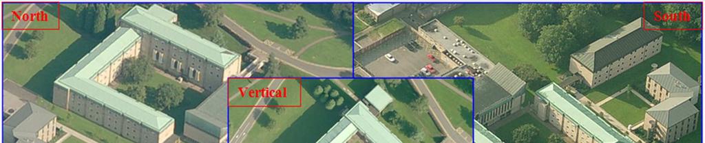
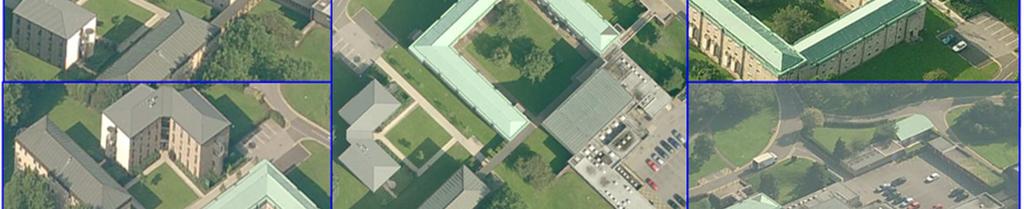
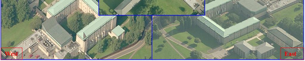
3 Aims and objectives The overall aim is to investigate the geometric potential of using the Pictometry images for 3D modelling and texturing. This aim will be assessed through investigating the following objectives: - Assessment of the images. - Benefits in combining Pictometry imagery with UltraCamD images. - Investigating the geometric quality of feature extraction. - Assessment of 3D geometry of all buildings extracted using both photogrammetric systems: Pictometry and UltraCamD. - Investigation into the quality of texturing the 3D models using vertical, oblique and combined blocks of both camera systems. Test site and data The University of Nottingham, University Park Campus Pictometry images 27 vertical images (nominally f = 65mm) forward overlap 38% to 46%, side lap 25% to 36% 57 oblique images (nominally f = 85mm) forward overlap 21% to 47%, side lap 23% to 45% GSD of 10-15cm pixel size is 9µm Nominal flying height is 1000m
4 Test site and data UltraCamD images 86 images (nominally f = 100mm) forward overlap 60%, side lap 30% GSD 6cm - pixel size 9µm Nominal flying height 500m Pictometry Imagery Pictometry is a digital mapping process; it comprises: - A five-camera system to capture a site of interest obliquely from the four cardinal points of the compass in addition to the traditional vertical view - An image warehouse to store the imagery - EFS (electronic field study ) viewing software to work with Pictometry imagery - An integrated system for position and orientation
 Pictometry Imagery Pictometry images are usually taken from two different levels:")
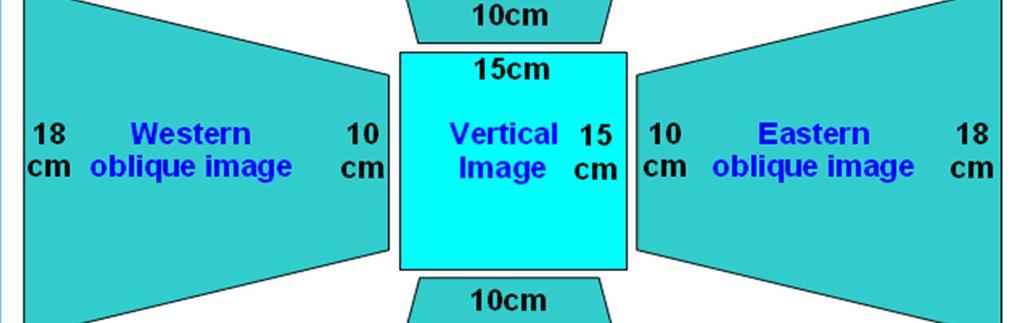
 2- Neighbourhood images - Flying height of 600 to 1000m - Average resolution of about 15cm/pixel (10cm at front and 18cm at back of")
5 Pictometry Imagery Pictometry images consist of two types of images: - Orthogonal (traditional straight down) images (about 20% of images) - Oblique images: images taken at an angle between 45 and 60 (about 80% of images) Pictometry Imagery Pictometry images are usually taken from two different levels: community and neighbourhood 1- Community images - Flying height of 1500 to 1800m - Average resolution of about 60cm/pixel (45cm at front and 90cm at back of oblique image) 2- Neighbourhood images - Flying height of 600 to 1000m - Average resolution of about 15cm/pixel (10cm at front and 18cm at back of oblique image)

6
7 Results: general All computations were performed using LPS Ground coordinated points (total 39) observations performed manually to natural detail points little more difficult to observe on the oblique due to tilt and scale differences Vertical Pictometry images: tie points automatically generated Oblique Pictometry images: manual measurement of tie points Tie points between vertical and oblique images were created through the ground control points Results: general Four solutions have been considered; Solution Control GPS IMU GCPs Additional parameters Float Large Large Small with and without Constrained Realistic Realistic Small with and without Integrated Realistic Realistic No with and without DG solution Fixed Fixed No with and without Small, Large and Realistic: Standard deviation value Small = high weight Large = small weight Realistic = actual estimated value


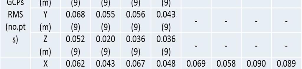
8 UltraCamD block results UltraCamD block results
 X(m) Y(m) Z(m) 0.025 0.038 0.009 0.024 0.028 0.006 0.029 0.040 0.011 0.025 0.035 0.011 - - - - - - - - - - - - CCPs RMS (no. pts) X(m) Y(m) Z(m) 0.094 0.082 0.295 0.089 0.076 0.")
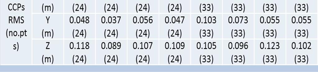
9 Vertical Pictometry images block Vertical Pictometry images block Solution Float Constrained Integrated DG AP No Yes No Yes No Yes No Yes Total image RMSE(µm) GCPs RMS (no.pts) X(m) Y(m) Z(m) CCPs RMS (no. pts) X(m) Y(m) Z(m) (29) (29) (29) (29) (29) (29) (26) (26) (26) (26) (26) (26)
 3.")


10 Oblique Pictometry images block Oblique Pictometry images block Solution Float Constrained Integrated DG AP No Yes No Yes No Yes No Yes Total image RMSE(µm) GCPs RMS (no.pts) X(m) Y(m) Z(m) CCPs RMS (no. pts) X(m) Y(m) Z(m)
 3.4 3.3 3.5 3.4 3.5 3.1 GCPs RMS (no.pts) CCPs RMS (no.")
 0.226 (39) 0.212 (39) 0.158 (39) 0.198 (39) 0.")
11 Combined UltraCamD and Pictometry imagery block Combined UltraCamD and Pictometry imagery block Solution Float Constrained Integrated AP No Yes No Yes No Yes Total RMSE(µm) GCPs RMS (no.pts) CCPs RMS (no.pts) X(m) Y(m) Z(m) X(m) Y(m) Z(m) (39) (39) (39) (39) (39) (39)

")


12 Modelling results Accuracy of 3D models extracted from Pictometry imagery. (qualitative evaluation) Modelling results Quantitative evaluation: planimetric and height accuracy were compared with the BM models Component X Y Avg. Z Min Max St.dev


13 Texturing results Texturing of the 3D polygons was performed using: the vertical Pictometry block, oblique Pictometry block, UltraCamD block, a combined (vertical and oblique) Pictometry block, and combined UltraCamD and Pictometry block. The visual inspection of the textured models show that using either vertical Pictometry block or UltraCamD block has given very good roof structure when it comes to façade texturing the quality was not as good as roofs quality, the texture quality of the building facades is considerably degraded.


14 Texturing results When only the block of oblique images was used for texturing the 3D models, the façade texturing was of very good quality but the texturing quality of some buildings roofs was reduced compared with the vertical images Combining both vertical and oblique images gives the benefit of good quality textures for both the roofs and facades Texturing using oblique images block


15 Texturing using combined UltraCamD and oblique images block Analysis of texturing results some of the 3D models contain errors especially in terms of texturing - The overall quality of the Pictometry images is characterized in some instances by the presence of haze which affects the texture mapping quality


16 Analysis of texturing results - Buildings with internal quadrangles are very challenging to texture from airborne images Analysis of texturing results - The effect of dead ground; area that cannot be seen from the aerial images due to shadow or perspective view


17 Analysis of texturing results - The most important factor that affects the texturing quality is occlusion Occlusion caused by vegetation and tall trees
18 CONCLUSION The use of combined blocks of vertical and oblique images in AT showed that good point coordination can be achieved. The results show that the revolutionary Pictometry oblique imagery can be used for texture mapping large models quickly and can enable photorealism. Terrestrial imagery might be combined with oblique imagery in certain areas to give better quality models, particularly when ground level viewing of the models is required. Acknowledgement BLOM Aerofilms Limited Thanks a lot
THE INTERIOR AND EXTERIOR CALIBRATION FOR ULTRACAM D
 THE INTERIOR AND EXTERIOR CALIBRATION FOR ULTRACAM D K. S. Qtaishat, M. J. Smith, D. W. G. Park Civil and Environment Engineering Department, Mu ta, University, Mu ta, Karak, Jordan, 61710 khaldoun_q@hotamil.com
AN INTEGRATED SENSOR ORIENTATION SYSTEM FOR AIRBORNE PHOTOGRAMMETRIC APPLICATIONS
 AN INTEGRATED SENSOR ORIENTATION SYSTEM FOR AIRBORNE PHOTOGRAMMETRIC APPLICATIONS M. J. Smith a, *, N. Kokkas a, D.W.G. Park b a Faculty of Engineering, The University of Nottingham, Innovation Park, Triumph
SimActive and PhaseOne Workflow case study. By François Riendeau and Dr. Yuri Raizman Revision 1.0
 SimActive and PhaseOne Workflow case study By François Riendeau and Dr. Yuri Raizman Revision 1.0 Contents 1. Introduction... 2 1.1. Simactive... 2 1.2. PhaseOne Industrial... 2 2. Testing Procedure...
Phase One ixa-r-180 Aerial Triangulation
 Phase One ixa-r-180 Aerial Triangulation Accuracy Assessment Results Revision 1 Oodi Menaker and Stephen Epstein Table of Contents 1. Introduction... 1 2. Method... 1 2.1. Selection of Test Area... 2 2.2.
Oblique aerial imagery in the praxis: applications and challenges
 ISPRS / EuroSDR Workshop on Oblique aerial cameras sensors and data processing Barcelona, 10 October 2017 Oblique aerial imagery in the praxis: applications and challenges Daniela Poli, Kjersti Moe, Klaus
Assessing the Performance of Different Direct-Georeferencing with Large Format Digital Cameras
 Assessing the Performance of Different Direct-Georeferencing with Large Format Digital Cameras Civil and Environment Engineering Department, Mu ta University, Mu ta, Al-Karak, Jordan, 61710. E.mail: khaldoun_q@hotamil.com
EVOLUTION OF POINT CLOUD
 Figure 1: Left and right images of a stereo pair and the disparity map (right) showing the differences of each pixel in the right and left image. (source: https://stackoverflow.com/questions/17607312/difference-between-disparity-map-and-disparity-image-in-stereo-matching)
Tree height measurements and tree growth estimation in a mire environment using digital surface models
 Tree height measurements and tree growth estimation in a mire environment using digital surface models E. Baltsavias 1, A. Gruen 1, M. Küchler 2, P.Thee 2, L.T. Waser 2, L. Zhang 1 1 Institute of Geodesy
INTEGRATION OF MOBILE LASER SCANNING DATA WITH UAV IMAGERY FOR VERY HIGH RESOLUTION 3D CITY MODELING
 INTEGRATION OF MOBILE LASER SCANNING DATA WITH UAV IMAGERY FOR VERY HIGH RESOLUTION 3D CITY MODELING Xianfeng Huang 1,2 Armin Gruen 1, Rongjun Qin 1 Tangwu Du 1, Wei Fang 1 1 Singapore-ETH Center, Future
BUNDLE BLOCK ADJUSTMENT WITH HIGH RESOLUTION ULTRACAMD IMAGES
 BUNDLE BLOCK ADJUSTMENT WITH HIGH RESOLUTION ULTRACAMD IMAGES I. Baz*, G. Buyuksalih*, K. Jacobsen** * BIMTAS, Tophanelioglu Cad. ISKI Hizmet Binasi No:62 K.3-4 34460 Altunizade-Istanbul, Turkey gb@bimtas.com.tr
Automated Processing for 3D Mosaic Generation, a Change of Paradigm
 Automated Processing for 3D Mosaic Generation, a Change of Paradigm Frank BIGNONE, Japan Key Words: 3D Urban Model, Street Imagery, Oblique imagery, Mobile Mapping System, Parallel processing, Digital
MODEL DEFORMATION ACCURACY OF DIGITAL FRAME CAMERAS
 MODEL DEFORMATION ACCURACY OF DIGITAL FRAME CAMERAS V. Spreckels a, A. Schlienkamp a, K. Jacobsen b a Deutsche Steinkohle AG (DSK), Dept. Geoinformation/Engineering Survey BG G, Shamrockring 1, D-44623
THE ISPRS/EUROSDR BENCHMARK ON MULTI-PLATFORM PHOTOGRAMMETRY: RESULTS AND LESSON LEARNT FRANCESCO NEX AND MARKUS GERKE
 THE ISPRS/EUROSDR BENCHMARK ON MULTI-PLATFORM PHOTOGRAMMETRY: RESULTS AND LESSON LEARNT FRANCESCO NEX AND MARKUS GERKE Overview Summary of the results Statistics Data release What s next? ISPRS / EuroSDR
STATUS OF AIRBORNE OBLIQUE IMAGING EUROSDR COMMISSION I PROJECT OBLIQUE IMAGERY. Markus Gerke May 15, 2014
 STATUS OF AIRBORNE OBLIQUE IMAGING EUROSDR COMMISSION I PROJECT OBLIQUE IMAGERY Markus Gerke May 15, 2014 THE FIRST AIRBORNE PHOTOS WERE OBLIQUE First recorded aerial photograph in the US (Boston), by
Trimble VISION Positions from Pictures
 Trimble VISION Positions from Pictures This session will cover What Is Trimble VISION? Trimble VISION Portfolio What Do you Need? How Does It Work & How Accurate Is It? Applications Resources Trimble VISION
DIGITAL SURFACE MODELS OF CITY AREAS BY VERY HIGH RESOLUTION SPACE IMAGERY
 DIGITAL SURFACE MODELS OF CITY AREAS BY VERY HIGH RESOLUTION SPACE IMAGERY Jacobsen, K. University of Hannover, Institute of Photogrammetry and Geoinformation, Nienburger Str.1, D30167 Hannover phone +49
Overview of the Trimble TX5 Laser Scanner
 Overview of the Trimble TX5 Laser Scanner Trimble TX5 Revolutionary and versatile scanning solution Compact / Lightweight Efficient Economical Ease of Use Small and Compact Smallest and most compact 3D
Multiray Photogrammetry and Dense Image. Photogrammetric Week Matching. Dense Image Matching - Application of SGM
 Norbert Haala Institut für Photogrammetrie Multiray Photogrammetry and Dense Image Photogrammetric Week 2011 Matching Dense Image Matching - Application of SGM p q d Base image Match image Parallax image
DENSE MATCHING IN HIGH RESOLUTION OBLIQUE AIRBORNE IMAGES
 In: Stilla U, Rottensteiner F, Paparoditis N (Eds) CMRT09. IAPRS, Vol. XXXVIII, Part 3/W4 --- Paris, France, 3-4 September, 2009 DENSE MATCHING IN HIGH RESOLUTION OBLIQUE AIRBORNE IMAGES M. Gerke International
TRIMBLE BUSINESS CENTER PHOTOGRAMMETRY MODULE
 TRIMBLE BUSINESS CENTER PHOTOGRAMMETRY MODULE WHITE PAPER TRIMBLE GEOSPATIAL DIVISION WESTMINSTER, COLORADO, USA July 2013 ABSTRACT The newly released Trimble Business Center Photogrammetry Module is compatible
Drone2Map for ArcGIS: Bring Drone Imagery into ArcGIS. Will
 Drone2Map for ArcGIS: Bring Drone Imagery into ArcGIS Will Meyers @MeyersMaps A New Window on the World Personal Mapping for Micro-Geographies Accurate High Quality Simple Low-Cost Drone2Map for ArcGIS
Absolute Horizontal Accuracies of Pictometry s Individual Orthogonal Frame Imagery
 A Pictometry International, Corp White Paper Absolute Horizontal Accuracies of Pictometry s Individual Orthogonal Frame Imagery Michael J. Zoltek VP, Surveying & Mapping Pictometry International, Corp
Lecture 11. LiDAR, RADAR
 NRMT 2270, Photogrammetry/Remote Sensing Lecture 11 Calculating the Number of Photos and Flight Lines in a Photo Project LiDAR, RADAR Tomislav Sapic GIS Technologist Faculty of Natural Resources Management
Unwrapping of Urban Surface Models
 Unwrapping of Urban Surface Models Generation of virtual city models using laser altimetry and 2D GIS Abstract In this paper we present an approach for the geometric reconstruction of urban areas. It is
EVALUATION OF WORLDVIEW-1 STEREO SCENES AND RELATED 3D PRODUCTS
 EVALUATION OF WORLDVIEW-1 STEREO SCENES AND RELATED 3D PRODUCTS Daniela POLI, Kirsten WOLFF, Armin GRUEN Swiss Federal Institute of Technology Institute of Geodesy and Photogrammetry Wolfgang-Pauli-Strasse
3D recording of archaeological excavation
 5 th International Conference Remote Sensing in Archaeology The Age of Sensing 13-15 October 2014 - Duke University 3D recording of archaeological excavation Stefano Campana UNIVERSITY of CAMBRIDGE Faculty
a Geo-Odyssey of UAS LiDAR Mapping Henno Morkel UAS Segment Specialist DroneCon 17 May 2018
 a Geo-Odyssey of UAS LiDAR Mapping Henno Morkel UAS Segment Specialist DroneCon 17 May 2018 Abbreviations UAS Unmanned Aerial Systems LiDAR Light Detection and Ranging UAV Unmanned Aerial Vehicle RTK Real-time
Advanced point cloud processing
 Advanced point cloud processing George Vosselman ITC Enschede, the Netherlands INTERNATIONAL INSTITUTE FOR GEO-INFORMATION SCIENCE AND EARTH OBSERVATION Laser scanning platforms Airborne systems mounted
Texturing Techniques in 3D City Modeling
 Texturing Techniques in 3D City Modeling 1 İdris Kahraman, 2 İsmail Rakıp Karaş, Faculty of Engineering, Department of Computer Engineering, Karabuk University, Turkey 1 idriskahraman@karabuk.edu.tr, 2
REMOTE SENSING LiDAR & PHOTOGRAMMETRY 19 May 2017
 REMOTE SENSING LiDAR & PHOTOGRAMMETRY 19 May 2017 SERVICES Visual Inspections Digital Terrain Models Aerial Imagery Volume Computations Thermal Inspections Photo maps Aerial Video Training & Consultancy
SPAR, ELMF 2013, Amsterdam. Laser Scanning on the UK Highways Agency Network. Hamish Grierson Blom Uk
 SPAR, ELMF 2013, Amsterdam Laser Scanning on the UK Highways Agency Network Hamish Grierson Blom Uk www.blomasa.com www.blom-uk.co.uk Blom UK Part of the Blom Group Blom Group - Europe s largest aerial
Quality Accuracy Professionalism
 GeoWing - who are we? Mapping Data Service Provider Lidar Multispectral Topographic and Planimetric Maps Elevation Models Point Clouds / 3D Models Orthophotography FAA-Authorized UAS Operators WOSB / DBE
3D CITY MODELLING WITH CYBERCITY-MODELER
 1 3D CITY MODELLING WITH CYBERCITY-MODELER Kilian Ulm 1 and Daniela Poli 1 1. CyberCity AG, Zurich, Switzerland, (kilian.ulm, daniela.poli)@cybercity.tv ABSTRACT 3D city models using stereo aerial-/satellite
GEOMETRY AND INFORMATION CONTENTS OF LARGE SIZE DIGITAL FRAME CAMERAS
 GEOMETRY AND INFORMATION CONTENTS OF LARGE SIZE DIGITAL FRAME CAMERAS Karsten Jacobsen Institute of Photogrammetry and Geoinformation Leibniz University Hannover jacobsen@ipi.uni-hannover.de KEY WORDS:
Quality Assurance and Quality Control Procedures for Survey-Grade Mobile Mapping Systems
 Quality Assurance and Quality Control Procedures for Survey-Grade Mobile Mapping Systems Latin America Geospatial Forum November, 2015 Agenda 1. Who is Teledyne Optech 2. The Lynx Mobile Mapper 3. Mobile
Intelligent photogrammetry. Agisoft
 Intelligent photogrammetry Agisoft Agisoft Metashape is a cutting edge software solution, with its engine core driving photogrammetry to its ultimate limits, while the whole system is designed to deliver
1. Introduction. A CASE STUDY Dense Image Matching Using Oblique Imagery Towards All-in- One Photogrammetry
 Submitted to GIM International FEATURE A CASE STUDY Dense Image Matching Using Oblique Imagery Towards All-in- One Photogrammetry Dieter Fritsch 1, Jens Kremer 2, Albrecht Grimm 2, Mathias Rothermel 1
2. POINT CLOUD DATA PROCESSING
 Point Cloud Generation from suas-mounted iphone Imagery: Performance Analysis A. D. Ladai, J. Miller Towill, Inc., 2300 Clayton Road, Suite 1200, Concord, CA 94520-2176, USA - (andras.ladai, jeffrey.miller)@towill.com
Drone2Map: an Introduction. October 2017
 Drone2Map: an Introduction October 2017 Drone2Map: An Introduction Topics: - Introduction to Drone Mapping - Coordinate Systems - Overview of Drone2Map - Basic Drone2Map Workflow - 2D Data Processing -
A NEW STRATEGY FOR DSM GENERATION FROM HIGH RESOLUTION STEREO SATELLITE IMAGES BASED ON CONTROL NETWORK INTEREST POINT MATCHING
 A NEW STRATEGY FOR DSM GENERATION FROM HIGH RESOLUTION STEREO SATELLITE IMAGES BASED ON CONTROL NETWORK INTEREST POINT MATCHING Z. Xiong a, Y. Zhang a a Department of Geodesy & Geomatics Engineering, University
OBLIQUE AERIAL IMAGES: POTENTIALITIES, APPLICATIONS AND BEST PRACTICES FRANCESCO NEX
 OBLIQUE AERIAL IMAGES: POTENTIALITIES, APPLICATIONS AND BEST PRACTICES FRANCESCO NEX f.nex@utwente.nl The history of oblique imagery First recorded aerial photo in the US (1860) by J.W. Black and S. King
GRAPHICS TOOLS FOR THE GENERATION OF LARGE SCALE URBAN SCENES
 GRAPHICS TOOLS FOR THE GENERATION OF LARGE SCALE URBAN SCENES Norbert Haala, Martin Kada, Susanne Becker, Jan Böhm, Yahya Alshawabkeh University of Stuttgart, Institute for Photogrammetry, Germany Forename.Lastname@ifp.uni-stuttgart.de
Surveying like never before
 CAD functionalities GCP Mapping and Aerial Image Processing Software for Land Surveying Specialists Surveying like never before www.3dsurvey.si Modri Planet d.o.o., Distributors: info@3dsurvey.si +386
Mountain mapping and DSM generation using high resolution satellite image data
 Mountain mapping and DSM generation using high resolution satellite image data Mountain Mapping and Visualization Lenk, Switzerland, February 2008 K. Wolff, A. Grün Institut für Geodesie und Photogrammetrie
Photogrammetry for forest inventory.
 Photogrammetry for forest inventory. Marc Pierrot Deseilligny. IGN/ENSG, France. Jonathan Lisein. Ulg Gembloux Agro-Bio Tech, Belgium. 1- Photogrammetry 2- Application to forestry 3- Tools and proposed
UAS Campus Survey Project
 ARTICLE STUDENTS CAPTURING SPATIAL INFORMATION NEEDS UAS Campus Survey Project Texas A&M University- Corpus Christi, home to the largest geomatics undergraduate programme in Texas, USA, is currently undergoing
INCORPORATING SCENE CONSTRAINTS INTO THE TRIANGULATION OF AIRBORNE OBLIQUE IMAGES
 INCORPORATING SCENE CONSTRAINTS INTO THE TRIANGULATION OF AIRBORNE OBLIQUE IMAGES M. Gerke and A.P. Nyaruhuma International Institute for Geo-Information Science and Earth Observation ITC, Department of
Photogrammetric Performance of an Ultra Light Weight Swinglet UAV
 Photogrammetric Performance of an Ultra Light Weight Swinglet UAV J. Vallet, F. Panissod, C. Strecha, M. Tracol UAV-g 2011 - Unmanned Aerial Vehicle in Geomatics September 14-16, 2011ETH Zurich Summary
Course Outline (1) #6 Data Acquisition for Built Environment. Fumio YAMAZAKI
 #6 Data Acquisition for Built Environment. Fumio YAMAZAKI") AT09.98 Applied GIS and Remote Sensing for Disaster Mitigation #6 Data Acquisition for Built Environment 9 October, 2002 Fumio YAMAZAKI yamazaki@ait.ac.th http://www.star.ait.ac.th/~yamazaki/ Course Outline
AT09.98 Applied GIS and Remote Sensing for Disaster Mitigation #6 Data Acquisition for Built Environment 9 October, 2002 Fumio YAMAZAKI yamazaki@ait.ac.th http://www.star.ait.ac.th/~yamazaki/ Course Outline
Towards Virtual Reality GIS
 'Photogrammetric Week 05' Dieter Fritsch, Ed. Wichmann Verlag, Heidelberg 2005. Haala 285 Towards Virtual Reality GIS NORBERT HAALA, Stuttgart ABSTRACT Due to the rapid developments in the field of computer
P h a s e O n e i X U - RS A c c u r a c y A n a l y s i s. T h e f o r e f r o n t o f a e r i a l p h o t o g r a p h y
 P h a s e O n e i X U - RS1 0 0 0 A c c u r a c y A n a l y s i s T h e f o r e f r o n t o f a e r i a l p h o t o g r a p h y 1 Phase One Industrial Aerial Survey Products ixu-rs1000, ixu1000 series
AUTOMATIC DETECTION OF BUILDINGS WITH RECTANGULAR FLAT ROOFS FROM MULTI-VIEW OBLIQUE IMAGERY
 AUTOMATIC DETECTION OF BUILDINGS WITH RECTANGULAR FLAT ROOFS FROM MULTI-VIEW OBLIQUE IMAGERY J. Xiao *, M. Gerke, G. Vosselman Faculty of Geo-Information Science and Earth Observation, University of Twente,
MAPPING WITHOUT GROUND CONTROL POINTS: DOES IT WORK?
 MAPPING WITHOUT GROUND CONTROL POINTS: DOES IT WORK? BACKGROUND The economic advantages of Structure from Motion (SfM) mapping without any ground control points have motivated us to investigate an approach
3D Data Modelling at Esri. Paul Hardy Business Development Consultant Esri Europe
 3D Data Modelling at Esri Paul Hardy phardy@esri.com Business Development Consultant Esri Europe Users of 3D GIS Local government Facilities management Civil engineering 3D GIS Defense / Public Safety
Near-Infrared Dataset. 101 out of 101 images calibrated (100%), all images enabled
, all images enabled") Dronedata Back Office Server Generated Quality Report Phase 1 Time 01h:22m:16s Phase 2 Time 00h:11m:39s Phase 3 Time 00h:01m:40s Total Time All Phases 01:35m:35s Generated with Pix4Dmapper Pro - TRIAL
Dronedata Back Office Server Generated Quality Report Phase 1 Time 01h:22m:16s Phase 2 Time 00h:11m:39s Phase 3 Time 00h:01m:40s Total Time All Phases 01:35m:35s Generated with Pix4Dmapper Pro - TRIAL
SPOT-1 stereo images taken from different orbits with one month difference
 DSM Generation Almost all HR sensors are stereo capable. Some can produce even triplettes within the same strip (facilitating multi-image matching). Mostly SPOT (1-5) used for stereo and Ikonos (in spite
OBLIQUE AERIAL IMAGERY A REVIEW
 OBLIQUE AERIAL IMAGERY A REVIEW FABIO REMONDINO 3D Optical Metrology unit Bruno Kessler Foundation (FKB) Trento, Italy http://3dom.fbk.eu Email: remondino@fbk.eu MARKUS GERKE EOS dept. ITC / Univ. Twente,
PERFORMANCE OF LARGE-FORMAT DIGITAL CAMERAS
 PERFORMANCE OF LARGE-FORMAT DIGITAL CAMERAS K. Jacobsen Institute of Photogrammetry and GeoInformation, Leibniz University Hannover, Germany jacobsen@ipi.uni-hannover.de Inter-commission WG III/I KEY WORDS:
2017 PROGRAM OVERVIEW. Geospatial Intelligence for Better Outcomes
 2017 PROGRAM OVERVIEW Geospatial Intelligence for Better Outcomes NICB SOLUTION : GEOSPATIAL INTELLIGENCE CENTER Key Program Areas 1. CAT / Disaster Response 2. National Imagery Program 3. Digital Delivery
An Introduction to Lidar & Forestry May 2013
 An Introduction to Lidar & Forestry May 2013 Introduction to Lidar & Forestry Lidar technology Derivatives from point clouds Applied to forestry Publish & Share Futures Lidar Light Detection And Ranging
Optimizing the use of digital airborne images for 2.5D visualization
 GeoInformation in Europe, M.A. Gomarsca (ed.) Ó2007 Millpress, Netherlands, ISBN 9789059660618 Optimizing the use of digital airborne images for 2.5D visualization A.S. Sima & S.A.W. Kay Agriculture and
Pictometry: Potentials for Land Administration 1
 1 Mathias LEMMENS, Christiaan LEMMEN and Martin WUBBE, The Netherlands Key words: Pictometry, oblique images, photogrammetry, cadastre and land registration, topographic mapping. SUMMARY The Netherlands'
AUTOMATIC EXTRACTION OF BUILDING ROOFS FROM PICTOMETRY S ORTHOGONAL AND OBLIQUE IMAGES
 AUTOMATIC EXTRACTION OF BUILDING ROOFS FROM PICTOMETRY S ORTHOGONAL AND OBLIQUE IMAGES Yandong Wang Pictometry International Corp. Suite A, 100 Town Centre Dr., Rochester, NY14623, the United States yandong.wang@pictometry.com
Tools, Tips and Workflows Geiger-Mode LIDAR Workflow Review GeoCue, TerraScan, versions and above
 GeoCue, TerraScan, versions 015.005 and above Martin Flood August 8, 2016 Geiger-mode lidar data is getting a lot of press lately as the next big thing in airborne data collection. Unlike traditional lidar
FAST PRODUCTION OF VIRTUAL REALITY CITY MODELS
 FAST PRODUCTION OF VIRTUAL REALITY CITY MODELS Claus Brenner and Norbert Haala Institute for Photogrammetry (ifp) University of Stuttgart Geschwister-Scholl-Straße 24, 70174 Stuttgart, Germany Ph.: +49-711-121-4097,
INTERPRETING BUILDING FAÇADES FROM VERTICAL AERIAL IMAGES USING THE THIRD DIMENSION
 INTERPRETING BUILDING FAÇADES FROM VERTICAL AERIAL IMAGES USING THE THIRD DIMENSION Meixner P. and Leberl F. Institute for Computer Graphics and Vision, Graz University of Technology, Inffeldgasse 16/II,
POSITIONING A PIXEL IN A COORDINATE SYSTEM
 GEOREFERENCING AND GEOCODING EARTH OBSERVATION IMAGES GABRIEL PARODI STUDY MATERIAL: PRINCIPLES OF REMOTE SENSING AN INTRODUCTORY TEXTBOOK CHAPTER 6 POSITIONING A PIXEL IN A COORDINATE SYSTEM The essential
GEOMETRY OF DIGITAL FRAME CAMERAS INTRODUCTION
 GEOMETRY OF DIGITAL FRAME CAMERAS Karsten Jacobsen Institute of Photogrammetry and Geoinformation Leibniz University Hannover Nienburger Str. 1, D-30167 Hannover, Germany jacobsen@ipi.uni-hannover.de Keywords:
Assessing the performance of commercial Agisoft PhotoScan software to deliver reliable data for accurate 3D modelling
 Assessing the performance of commercial Agisoft PhotoScan software to deliver reliable data for accurate 3D modelling Ahmed Jebur 1,*, Fanar Abed 2 and Mamoun Mohammed 1 1 Engineering Technical College,
PERFORMANCE ANALYSIS OF FAST AT FOR CORRIDOR AERIAL MAPPING
 PERFORMANCE ANALYSIS OF FAST AT FOR CORRIDOR AERIAL MAPPING M. Blázquez, I. Colomina Institute of Geomatics, Av. Carl Friedrich Gauss 11, Parc Mediterrani de la Tecnologia, Castelldefels, Spain marta.blazquez@ideg.es
Todd King, PLS, LEED AP Business Developer
 Todd King, PLS, LEED AP Business Developer TKing@McKimCreed.com 38 YEARS 378 EMPLOYEES ENR Top 500 Design Firm ENR Top 200 Environmental ENR Southeast Engineer Firms POB Geospatial Top 100 Top 50 Trenchless
Calibration and validation of digital airborne cameras
 Institut für Photogrammetrie ifp Calibration and validation of digital airborne cameras Michael Cramer Universität Stuttgart Institut für Photogrammetrie (ifp) Geschwister-Scholl-Str. 24D D-70174 Stuttgart
Photogrammetry: DTM Extraction & Editing
 Photogrammetry: DTM Extraction & Editing How can one determine the x, y, and z of a location? Approaches to DTM Extraction Ground surveying Digitized topographic maps Traditional photogrammetry Hardcopy
Quality Report Generated with Pro version
 Quality Report Generated with Pro version 2.1.61 Important: Click on the different icons for: Help to analyze the results in the Quality Report Additional information about the sections Click here for
INTEGRATING TERRESTRIAL LIDAR WITH POINT CLOUDS CREATED FROM UNMANNED AERIAL VEHICLE IMAGERY
 INTEGRATING TERRESTRIAL LIDAR WITH POINT CLOUDS CREATED FROM UNMANNED AERIAL VEHICLE IMAGERY Michael Leslar a * a Teledyne-Optech, 300 Interchange Way, Vaughan, Ontario, Canada, L4K 5Z8, Mike.Leslar@teledyneoptech.com
PRODUCTION SYSTEM FOR AUTONOMOUS 3-DIMENSIONAL MODELING WITH LIDAR, IFSAR, AND PHOTOGRAMMETRIC DSM DATA INTRODUCTION
 PRODUCTION SYSTEM FOR AUTONOMOUS 3-DIMENSIONAL MODELING WITH LIDAR, IFSAR, AND PHOTOGRAMMETRIC DSM DATA Mark Rahmes, Software Engineer Josef DeVaughn Allen, Software Engineer J. Harlan Yates, System Engineer
Terrestrial Laser Scanning: Applications in Civil Engineering Pauline Miller
 Terrestrial Laser Scanning: Applications in Civil Engineering Pauline Miller School of Civil Engineering & Geosciences Newcastle University Overview Laser scanning overview Research applications geometric
Photo based Terrain Data Acquisition & 3D Modeling
 Photo based Terrain Data Acquisition & 3D Modeling June 7, 2013 Howard Hahn Kansas State University Partial funding by: KSU Office of Research and Sponsored Programs Introduction: Need Application 1 Monitoring
Lecture 5. Relief displacement. Parallax. Monoscopic and stereoscopic height measurement. Photo Project. Soft-copy Photogrammetry.
 NRMT 2270, Photogrammetry/Remote Sensing Lecture 5 Relief displacement. Parallax. Monoscopic and stereoscopic height measurement. Photo Project. Soft-copy Photogrammetry. Tomislav Sapic GIS Technologist
GNSS/INS for High Accuracy Mobile Mapping. Olaf Gross 11 th Terrasolid European User Event Kittilä, Finland
 GNSS/INS for High Accuracy Mobile Mapping Olaf Gross 11 th Terrasolid European User Event 15.02.2012 Kittilä, Finland IGI mbh Founded 1978 25 staff about half in R&D More than 380 customers in 60 different
Outline of Presentation. Introduction to Overwatch Geospatial Software Feature Analyst and LIDAR Analyst Software
 Outline of Presentation Automated Feature Extraction from Terrestrial and Airborne LIDAR Presented By: Stuart Blundell Overwatch Geospatial - VLS Ops Co-Author: David W. Opitz Overwatch Geospatial - VLS
MAPPING CAPABILITY OF A LOW-COST AERIAL DATA ACQUISITION PLATFORM FIRST RESULTS
 MAPPING CAPABILITY OF A LOW-COST AERIAL DATA ACQUISITION PLATFORM FIRST RESULTS Hannes Raggam, Roland Wack, Karlheinz Gutjahr Joanneum Research, Institute of Digital Image Processing Wastiangasse 6, A-8010
DMC GEOMETRIC PERFORMANCE ANALYSIS
 DMC GEOMETRIC PERFORMANCE ANALYSIS R.Alamús a, W.Kornus a, I.Riesinger b a Cartographic Institute of Catalonia (ICC), Barcelona, Spain - (ramon.alamus; wolfgang.kornus)@icc.cat b Chair for Photogrammetry
LiDAR for Urban Change Detection. Keith W. Cunningham, PhD Alaska Satellite Facility November 13, 2009
 LiDAR for Urban Change Detection Keith W. Cunningham, PhD Alaska Satellite Facility November 13, 2009 LiDAR LiDAR Light Detection and Ranging Building Footprints GIS outlines (planimetrics) GIS Geographic
Comeback of Digital Image Matching
 Photogrammetric Week '09 Dieter Fritsch (Ed.) Wichmann Verlag, Heidelberg, 2009 Haala 289 Comeback of Digital Image Matching NORBERT HAALA, Stuttgart ABSTRACT Despite the fact that tools for automatic
Assessing 3D Point Cloud Fidelity of UAS SfM Software Solutions Over Varying Terrain
 Assessing 3D Point Cloud Fidelity of UAS SfM Software Solutions Over Varying Terrain Michael Schwind, Michael J. Starek (Presenter) 18th Annual JALBTCX Airborne Coastal Mapping and Charting Technical Workshop,
CURRENT DEVELOPMENTS IN AIRBORNE OBLIQUE IMAGING SYSTEMS AND AUTOMATED INTERPRETATION OF COMPLEX BUILDINGS. Markus Gerke
 CURRENT DEVELOPMENTS IN AIRBORNE OBLIQUE IMAGING SYSTEMS AND AUTOMATED INTERPRETATION OF COMPLEX BUILDINGS Markus Gerke THE FIRST AIRBORNE PHOTOS WERE OBLIQUE First recorded aerial photograph in the US
LIDAR MAPPING FACT SHEET
 1. LIDAR THEORY What is lidar? Lidar is an acronym for light detection and ranging. In the mapping industry, this term is used to describe an airborne laser profiling system that produces location and
Chapters 1 9: Overview
 Chapters 1 9: Overview Chapter 1: Introduction Chapters 2 4: Data acquisition Chapters 5 9: Data manipulation Chapter 5: Vertical imagery Chapter 6: Image coordinate measurements and refinements Chapters
Multi-ray photogrammetry: A rich dataset for the extraction of roof geometry for 3D reconstruction
 Multi-ray photogrammetry: A rich dataset for the extraction of roof geometry for 3D reconstruction Andrew McClune, Pauline Miller, Jon Mills Newcastle University David Holland Ordnance Survey Background
International Archives of Photogrammetry and Remote Sensing. Vol. XXXII, Part 5. Hakodate 1998
 International Archives of Photogrammetry and Remote Sensing. Vol. XXXII, Part 5. Hakodate 1998 RAPID ACQUISITION OF VIRTUAL REALITY CITY MODELS FROM MULTIPLE DATA SOURCES Claus Brenner and Norbert Haala
HIGH DENSITY AERIAL IMAGE MATCHING: STATE-OF-THE-ART AND FUTURE PROSPECTS
 HIGH DENSITY AERIAL IMAGE MATCHING: STATE-OF-THE-ART AND FUTURE PROSPECTS N. Haala a *, S. Cavegn a, b a Institute for Photogrammetry, University of Stuttgart, Germany - norbert.haala@ifp.uni-stuttgart.de
GENERATING BUILDING OUTLINES FROM TERRESTRIAL LASER SCANNING
 GENERATING BUILDING OUTLINES FROM TERRESTRIAL LASER SCANNING Shi Pu International Institute for Geo-information Science and Earth Observation (ITC), Hengelosestraat 99, P.O. Box 6, 7500 AA Enschede, The
Section 5 Orthoimage generation
 Section 5 Orthoimage generation Emmanuel Baltsavias Orthoimage Generation Older sensor models methods: Kratky s Polynomial Mapping Functions (PMFs) Relief corrected affine transformation - Project GCPs
ATOMI Automatic road centreline extraction
 ATOMI input and output data Ortho images DTM/DSM 2D inaccurate structured road vector data ATOMI Automatic road centreline extraction 3D accurate structured road vector data Classification of roads according
maps.live.com PHOTOGRAMMETRY EVOLUTION PHOTOGRAMMETRY EVOLUTION 3D Geospatial Data for the Internet
 PHOTOGRAMMETRY EVOLUTION ISPRS 1992 Film Scanning ISPRS 1996 Softcopy Stereo ISPRS 2000 Digital Cameras Shown ISPRS 2004 Using Digital Cameras THE INTERNET IS NOW SERVING GEODATA PHOTOGRAMMETRY EVOLUTION
Chapters 1-4: Summary
 Chapters 1-4: Summary So far, we have been investigating the image acquisition process. Chapter 1: General introduction Chapter 2: Radiation source and properties Chapter 3: Radiation interaction with
UAV-BASED DAMAGE MAPPING AND THE FP7-PROJECT RECONASS
 UAV-BASED DAMAGE MAPPING AND THE FP7-PROJECT RECONASS Norman Kerle. ESA Department ITC-OOA-Group (with materials by Markus Gerke, Jorge Fernandez and Anand Vetrivel) ITC/ University Twente International
Presented at the FIG Congress 2018, May 6-11, 2018 in Istanbul, Turkey
 Presented at the FIG Congress 2018, May 6-11, 2018 in Istanbul, Turkey Evangelos MALTEZOS, Charalabos IOANNIDIS, Anastasios DOULAMIS and Nikolaos DOULAMIS Laboratory of Photogrammetry, School of Rural
REFINEMENT OF BUILDING FASSADES BY INTEGRATED PROCESSING OF LIDAR AND IMAGE DATA
 In: Stilla U et al (Eds) PIA07. International Archives of Photogrammetry, Remote Sensing and Spatial Information Sciences, 36 (3/W49A) REFINEMENT OF BUILDING FASSADES BY INTEGRATED PROCESSING OF LIDAR