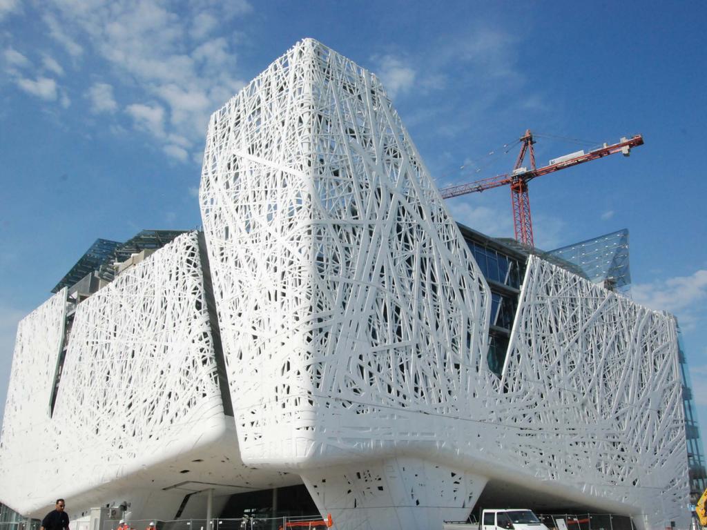
Advanced LiDAR technologies for the construction of the Italian Pavilion at the Milan Expo 2015
|
|
|
- Amy Warren
- 5 years ago
- Views:
Transcription


1 Distributor Meeting Singapore 2015 Advanced LiDAR technologies for the construction of the Italian Pavilion at the Milan Expo 2015 Matteo Sgrenzaroli, R&D Project Manager Lorenzo Cavallari, Project Engineer; Massimo Gelmini, Engineer; Giorgio Dotti, Surveyor, Gexcel, Italy

2

3

4
5
6
7
8
9
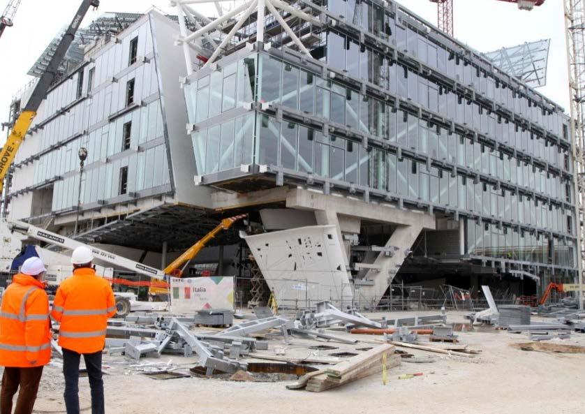
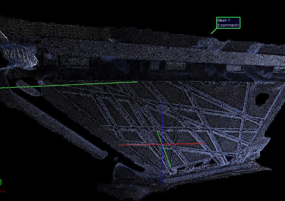
10 1 As built check and control of geometry and positioning of metal flanges and carpentries by first order total station 2 Millimetric Check of the concrete panels by first order total station and laser scanner 3 Global Building Survey by laser scanner and images
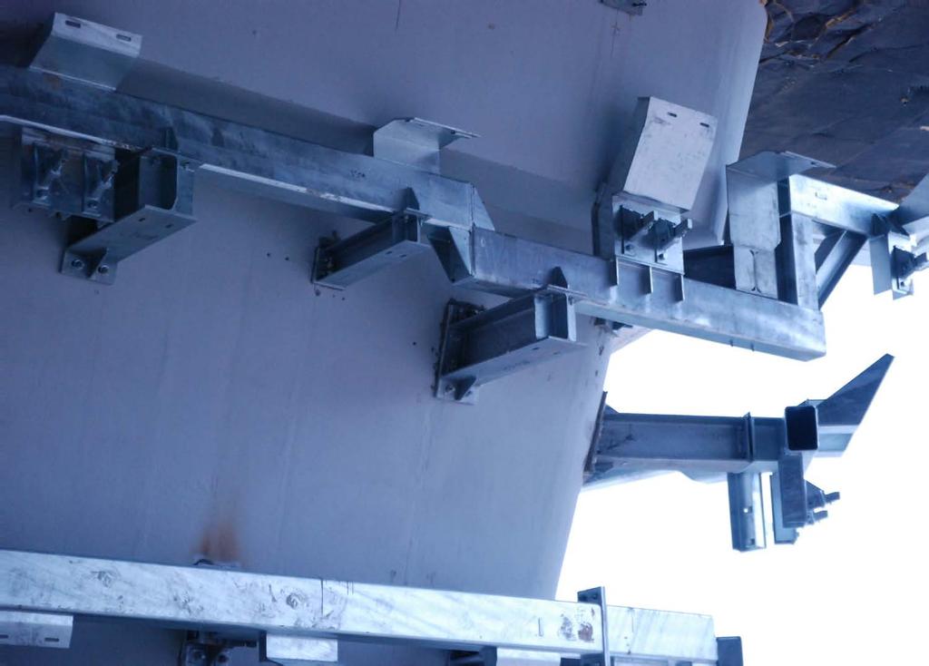
11 1 AS BUILT CHECK AND CONTROL OF GEOMETRY AND POSITIONING OF METAL FLANGES AND CARPENTRIES
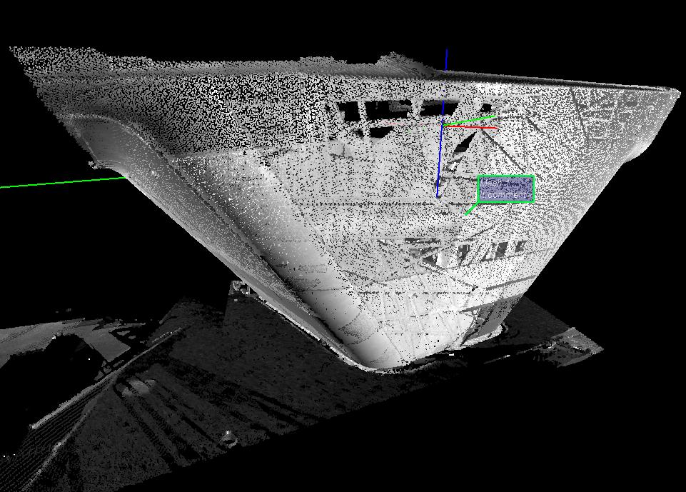
12 JRC 3D Reconstructor
13
14
15
16

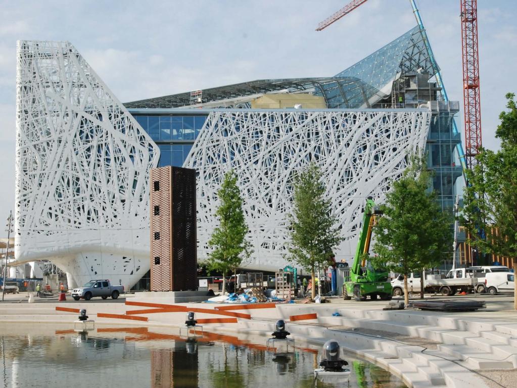
17 DISTRIBUTOR Distributor MEETING Meeting SINGAPORE Singapore ITALIAN PAVILION
18

19 DISTRIBUTOR Distributor MEETING Meeting SINGAPORE Singapore ITALIAN PAVILION GEXCEL PORTFOLIO D CHECK AS-BUILT AND PROJECT STATUS metal carpentry

20 3D CHECK AS-BUILT AND PROJECT STATUS metal carpentry

21 ITALIAN PAVILION Distributor Meeting Singapore D CHECK AS-BUILT AND PROJECT STATUS metal carpentry

22 3D CHECK AS-BUILT AND PROJECT STATUS metal carpentry

23 3D CHECK AS-BUILT AND PROJECT STATUS metal carpentry
24 2 MILLIMETRIC CHECK OF THE CONCRETE PANELS BY FIRST ORDER TOTAL STATION

25 JRC 3D Reconstructor

26 FROM THE 3D BIM PROJECT EVERY PANEL AND THE METALLIC SUPPORT HAVE BEEN IN REAL TIME MONITORED AND THE POSITION DEFINED USING LASER SCANNER AND TOTAL STATION. concrete covering panels
27 FROM THE 3D BIM PROJECT EVERY PANEL AND THE METALLIC SUPPORT HAVE BEEN IN REAL TIME MONITORED AND THE POSITION DEFINED USING LASER SCANNER AND TOTAL STATION. concrete covering panels

28 FROM THE 3D BIM PROJECT EVERY PANEL AND THE METALLIC SUPPORT HAVE BEEN IN REAL TIME MONITORED AND THE POSITION DEFINED USING LASER SCANNER AND TOTAL STATION. concrete covering panels

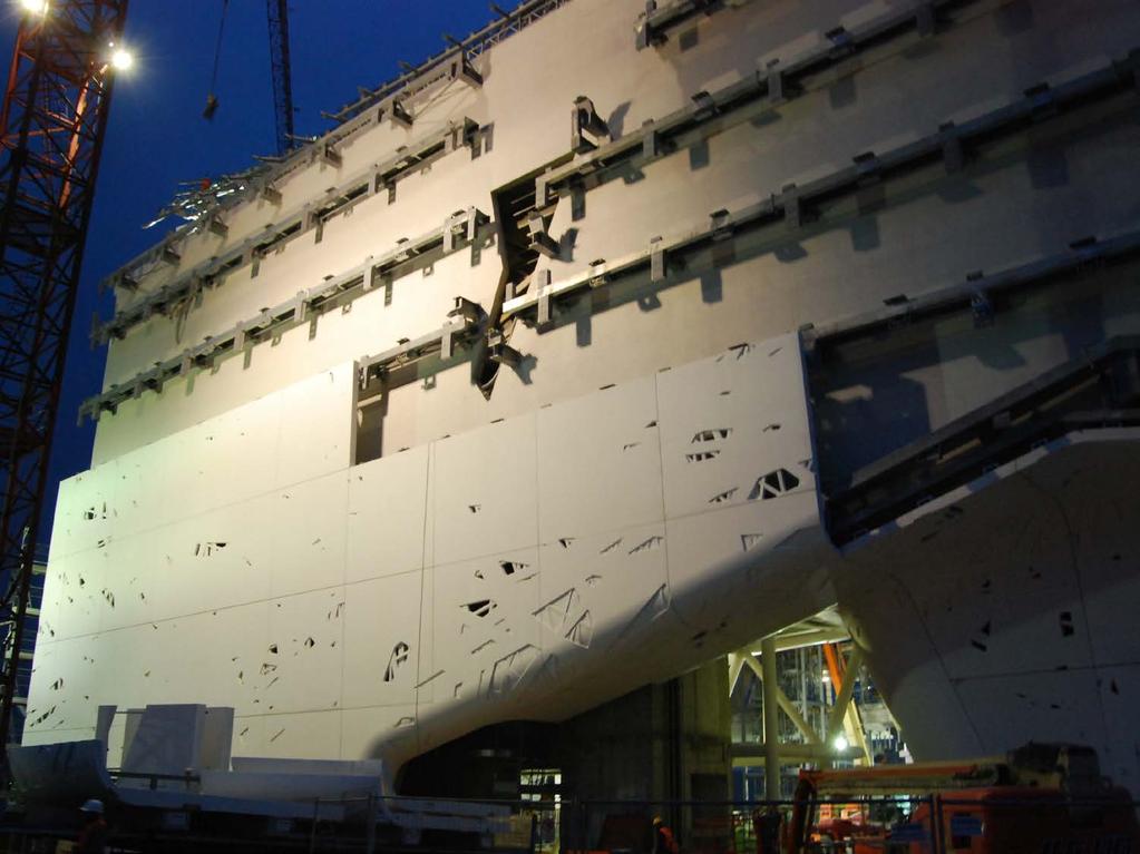
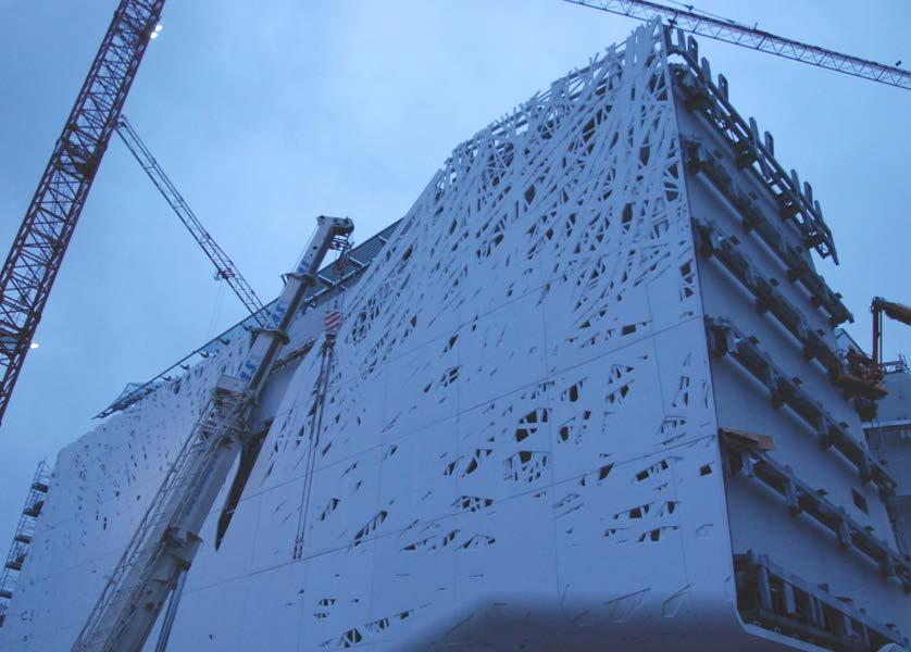
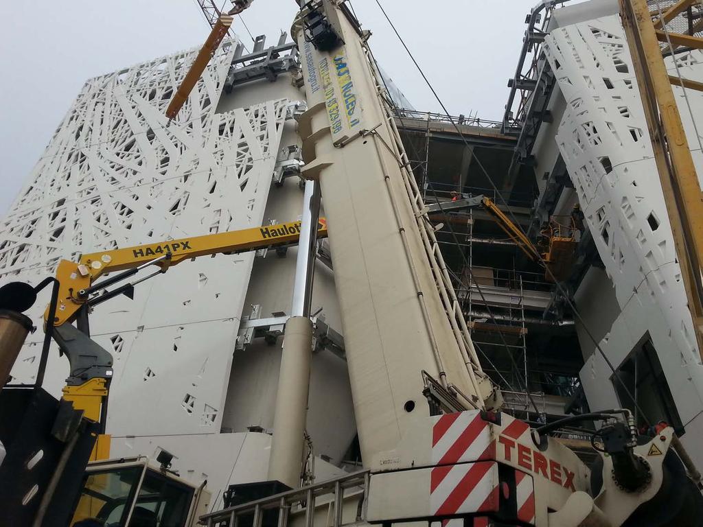
29 ITALIAN PAVILION THE CONSTRUCTION HAS BEEN LATER SURVEYED USING Z&F AND FARO LASER SCANNER. THE SCANS HAVE BEEN ALIGNED, ALMOST REAL TIME, USING A TARGET LESS PRE-ALIGNMENT AND BUNDLE ADJUSTMENT SOFTWARE PROCESS. concrete covering panels
30 ALL THE HEAVY CONCRETE PANELS, OF DIFFERENT SHAPES, HAVE BEEN POSITIONED WITH 2mm ACCURACY AND THE SCANNING AS BUILT DATA ACQUISITION AND PROCESSING HAS BEEN CARRIED IN ALMOST REAL TIME. concrete covering panels

31 THE PROCESS FROM BIM TO THE ON THE FIELD POSITIONING AND SCANNING HAS BEEN OPTIMIZED IN THE WAY TO REDUCE AT THE MINIMUM THE DATA PROCESSING TIME. concrete covering panels
32 3 GLOBAL BUILDING SURVEY


33 3D From images
34
35
36

37 ITALIAN PAVILION

38 4D INSPECTOR Fully Automatic

39 4D INSPECTOR Fully Automatic

40 Image from: urbanfilemilano.blogspot.com Distributor Meeting Singapore 2015 ISOZAKY TOWER CONSULTING

41 Image from: urbanfilemilano.blogspot.com Distributor Meeting Singapore 2015 UNICREDIT PALACE & BOSCO VERTICALE CONSULTING

42 Distributor Meeting Singapore 2015TORRE HADID

43 Distributor Meeting Singapore 2015TORRE HADID

44 Distributor Meeting Singapore 2015TORRE HADID

45 Distributor Meeting Singapore 2015TORRE HADID

46 Distributor Meeting Singapore 2015TORRE HADID BORDER AS BUILT CHECK JRC 3D Reconstructor + LineUp Pro + Focus 3D

47 Distributor Chintergeo Meeting 2015 Singapore 2015TORRE HADID ITALIAN PAVILION CORE VERTICALITY CHECK JRC 3D Reconstructor + LineUp Pro + Focus 3D

48 Distributor Chintergeo Meeting 2015 Singapore 2015TORRE HADID ITALIAN PAVILION CORE VERTICALITY / BORDER CHECK JRC 3D Reconstructor + LineUp Pro + Focus 3D


49 Distributor Chintergeo Meeting 2015 Singapore 2015TORRE HADID ITALIAN PAVILION Gexcel LineUp PRO ClearEdge 3D EdgeWiseTM
50 DO YOU NEED MORE INFORMATION?
Italian pavilion in 3D, project for EXPO 2015, Milan (Italy) JRC 3D RECONSTRUCTOR POWERFUL. ADVANCED. PROFESSIONAL
 JRC 3D RECONSTRUCTOR POWERFUL. ADVANCED. PROFESSIONAL") Italian pavilion in 3D, project for EXPO 2015, Milan (Italy) JRC 3D RECONSTRUCTOR POWERFUL. ADVANCED. PROFESSIONAL OVERVIEW JRC 3D Reconstructor is the well known multi-platform and multi-resolution software
Italian pavilion in 3D, project for EXPO 2015, Milan (Italy) JRC 3D RECONSTRUCTOR POWERFUL. ADVANCED. PROFESSIONAL OVERVIEW JRC 3D Reconstructor is the well known multi-platform and multi-resolution software
Gexcel. JRC 3D Reconstructor BASIC MEASURING TOOLS
 Gexcel JRC 3D Reconstructor BASIC MEASURING TOOLS In this tutorial you will learn how to Save snapshots of the 3D view Measure distances and angles of the 3D models Add annotations to the objects in the
UAVs & IMAGES ACCESSORIES ABOUT GEXCEL
 LIDAR SOFTWARE UAVs & IMAGES MONITORING MOBILE MAPPING ACCESSORIES OTHER ABOUT GEXCEL BUSINESS TEAM LOCATIONS Gexcel offices are located in Italy in two Innovation Centers SALES NETWORK Gexcel s worldwide
JRC 3D Reconstructor CAMERA CALIBRATION & ORIENTATION
 Gexcel JRC 3D Reconstructor CAMERA CALIBRATION & ORIENTATION In this tutorial you will learn how to Include in the project external digital pictures of the scene you are modeling Calculate the original
ROAD-SCANNER COMPACT APPLICATION FIELDS MAIN FEATURES
 ROAD-SCANNER COMPACT Mobile Mapping System by GEXCEL & SITECO collaboration A smaller mobile system for asset management and cartography suited for ZOLLER & FRÖHLICH PROFILER 9012 laser scanner. 2 + 3
LASER SCANNER SURVEY TO CULTURAL HERITAGE CONSERVATION AND RESTORATION
 LASER SCANNER SURVEY TO CULTURAL HERITAGE CONSERVATION AND RESTORATION G. Vacca a, *, M. Deidda a, A. Dessi a, M. Marras a a DICAAR, Engineering Faculty, University of Cagliari P.zza D Armi 09123 Cagliari,
HIGH-DEFINITION SURVEY AND BIM PRESENTATION FOR BIM-MEP AUS
 www.aamgroup.com/bim HIGH-DEFINITION SURVEY AND BIM PRESENTATION FOR BIM-MEP AUS Matt Rumbelow, B.Arch AAM BIM Coordinator ABOUT AAM Reality Captured. Certainty Delivered Reality Captured. Certainty Delivered
Reality Capture. Customer Case
 Reality Capture Customer Case Reality Capture customer case: MP-Map Oy Surveying company using FARO laser scanners MP-Map Oy is a construction surveying company with over 30 years of surveying experience
3D Terrestrial Laser Scanner Innovative Applications for 3D Documentation
 3D Terrestrial Laser Scanner Innovative Applications for 3D Documentation Rodney Chaffee Head of Sales, FARO Asia Pacific 3D Laser Scaning Market 2017 2.3 Billion $ 2012 1.3 Billion $ CAGR : > 12% Source:
Trimble Update. BIMnet 17 th June 2013 BUILDING CONSTRUCTION
 Trimble Update BIMnet 17 th June 2013 BUILDING CONSTRUCTION Agenda Introduction to Trimble What is Trimble BIM+Build? The benefits of BIM to Field Questions? 2 Trimble corporate roots Founded in 1978 Market
Trimble RealWorks. What s new in version 9.0
 Trimble RealWorks What s new in version 9.0 Trimble RealWorks v9.0 What s new Over 40 new features and enhancements Navigation and visualization improvements SketchUp interoperability Additional 3 rd party
Explore Laser Scanning in As-Built Survey. Vijay Chowdhary SE: BIM/CIM
 Explore Laser Scanning in As-Built Survey Vijay Chowdhary SE: BIM/CIM About FARO The world leader in portable 3-D measurement and imaging technology EMEA Headquarters Korntal-Münchingen, Germany APAC Headquarters
BIM for infrastructure make easy with Laser Scanner. 17 October Beng Chieh Quah Head of Marketing Asia Pacific
 BIM for infrastructure make easy with Laser Scanner 17 October 2016 Beng Chieh Quah Head of Marketing Asia Pacific who is? founded in 1981 NASDAQ since 1997 Global technology company Offering a range of
With FARO PointSense for Revit. Jörg Braunes Platform Owner Software Chris Palmer Sales Engineer 1
 From Point Clouds to BIM Models With FARO PointSense for Revit Jörg Braunes Platform Owner Software Chris Palmer Sales Engineer 1 Agenda Scan to BIM with Revit PointClouds in Revit Advanced Workflow with
Laser Scanning. 3D Model is not existing and is required for: studies revamping maintenance HSE integration in another 3D model archiving
 Laser Scanning Laser Scanning Laser scanning is used whenever: 3D Model is not existing and is required for: studies revamping maintenance HSE integration in another 3D model archiving 2 Object acquisition
NEW PERSPECTIVE SEPTEMBER 2017
 VOLUME 7 ISSUE 6 SEPTEMBER 2017 NEW PERSPECTIVE 18 26 38 POLARIS SHOWS THE WAY The terrestrial laser scanning market continues to evolve, providing today s practitioner with an abundance of options LITTLE
RealWorks Software. A Powerful 3D Laser Scanning Office Software Suite
 TECHNICAL NOTES RealWorks Software A Powerful 3D Laser Scanning Office Software Suite Trimble RealWorks is a powerful office software that imports rich data from your 3D laser scanning instrument and transforms
Using Laser Scanning technology and software. Chris Palmer Sales Engineer 28 th April
 Construction Verification Using Laser Scanning technology and software Chris Palmer Sales Engineer 28 th April 2017 1 Contents What is construction verification? How do we measure and check construction
Extracting Plant Deliverables from AutoCAD Point Clouds
 Extracting Plant Deliverables from AutoCAD Point Clouds The webinar will begin shortly. You will hear silence until the webinar begins. Please note that this webinar is being recorded and all registrants
Integration of Textural and Material Information Into Existing BIM Using IR Sensing. A research by: Asem Zabin Baha Khalil
 Integration of Textural and Material Information Into Existing BIM Using IR Sensing A research by: Asem Zabin Baha Khalil Asem Zabin Senior BIM Engineer at itech Management Consultancy Master of Science
3D SCANNING & 3D PRINTING. 2/21/2019 GINGER CHICOS and JUAN PINTO
 3D SCANNING & 2/21/2019 GINGER CHICOS and JUAN PINTO TYPES OF 3D SCANNERS MOST COMMONLY USED IN CONSTRUCTION LASER PULSE (LIDAR) STRUCTURED LIGHT PHOTOGRAMMETRY 3D SCANNING TYPES OF 3D SCANNERS LASER
Boosting the Efficiency of Wind Power Plants. Stringent Demands for Boosting the Efficiency of Wind Power Plants
 Case Study Boosting the Efficiency of Wind Power Plants By Steffen Schenk and Wolfgang Steindorf Three-dimensional measurement and analysis of rotor blades and their production facility are highly complex
Laser Scanning & Creation of 3D Models For BIM and Process Facilities
 Specialised Surveying Solutions Presented to: ICES UAE Region Abu Dhabi November 2009 Land and Engineering Surveying Services 3D Laser Scanning & Modeling Laser Scanning Technology Zoller+Fröhlich Phase
The YellowScan Surveyor: 5cm Accuracy Demonstrated
 The YellowScan Surveyor: 5cm Accuracy Demonstrated Pierre Chaponnière1 and Tristan Allouis2 1 Application Engineer, YellowScan 2 CTO, YellowScan Introduction YellowScan Surveyor, the very latest lightweight
GeoSLAM Overview. The global leader in go anywhere 3D mobile mapping technology. 1
 GeoSLAM Overview The global leader in go anywhere 3D mobile mapping technology. 1 About GeoSLAM The global leader in go anywhere 3D mobile mapping technology. 2 Who We Are GeoSLAM is a global market leader
technical notes trimble realworks software
 technical notes trimble realworks software A POWERFUL 3D LASER SCANNING OFFICE SOFTWARE SUITE Designed for today s multifaceted scanning professional, Trimble RealWorks is a powerful office software that
Trimble Realworks Software
 TECHNICAL NOTES Trimble Realworks Software A Powerful 3D Laser Scanning Office Software Suite DESIGNED FOR TODAY S MULTIFACETED SCANNING PROFESSIONAL, TRIMBLE REALWORKS IS A POWERFUL OFFICE SOFTWARE THAT
Open Pit Mines. Terrestrial LiDAR and UAV Aerial Triangulation for. Figure 1: ILRIS at work
 Terrestrial LiDAR and UAV Aerial Triangulation for Open Pit Mines Figure 1: ILRIS at work Figure 2: Geo-Copter X-8000 taking off ay what you will about the past few years, it has produced some useful tools
TLS Parameters, Workflows and Field Methods
 TLS Parameters, Workflows and Field Methods Marianne Okal, UNAVCO GSA, September 23 rd, 2016 How a Lidar instrument works (Recap) Transmits laser signals and measures the reflected light to create 3D point
The Institute of Remote Sensing and Digital Earth, Chinese Academy of Sciences liqi
 Fine Deformation Monitoring of Ancient Building Based on Terrestrial Laser Scanning Technologies The Institute of Remote Sensing and Digital Earth, Chinese Academy of Sciences liqi Outline Introduce the
2/19/2018. Who are we? Who am I? What is Scanning? How does scanning work? How does scanning work? Scanning for Today s Surveyors
 2/19/2018 Who are we? Scanning for Today s Surveyors Survey, GIS, and Construction dealer Founded in 1988 Employee Owned Headquartered in Bismarck, ND States covered: ND, SD, MN, MT, WY, CO, UT, ID, WA,
Realworks Software. A Powerful 3D Laser Scanning Office Software Suite
 TECHNICAL NOTES Realworks Software A Powerful 3D Laser Scanning Office Software Suite Trimble RealWorks is a powerful office software that imports rich data from your 3D laser scanning instrument and transforms
A New Way to Control Mobile LiDAR Data
 A New Way to Control Mobile LiDAR Data Survey control has always been a critically important issue when conducting mobile LiDAR surveys. While the accuracies currently being achieved with the most capable
Surveyor s. Time Machine. The. Product Review Triumph-LS software. Polaris Shows the Way Leveraging workflow
 SEPTEMBER 2017 The Surveyor s Time Machine Product Review Triumph-LS software Polaris Shows the Way Leveraging workflow Revitalizing a Business With laser scanning A WELL- PLANNED SUCCESS» FULVIO BERNARDINI
A 130 Year- Old Story
 A 130 Year- Old Story The Architectural Survey of the Hungarian State Opera CÉH Inc. of Budapest, Hungary was tasked with the enormous task of measuring and modeling the Hungarian State Opera House. The
EXPERT TIPS & TRICKS MAR/APR 2017
 VOLUME 7 ISSUE 2 MAR/APR 2017 EXPERT TIPS & TRICKS 21 27 30 DRONE-BASED LIDAR STUDY To evaluate the effectiveness of drone-based LIDAR tech Juniper Unmanned conducted a unique empirical study OIL AND GAS
3D Data Acquisition in Tunnels Optimizing Track Time Using Terrestrial Mobile LiDAR. Scanning. Michael R. Frecks, PLS.
 3D Data Acquisition in Tunnels Optimizing Track Time Using Terrestrial Mobile LiDAR Scanning Michael R. Frecks, PLS President/CEO AREMA 2013 1207 Understanding mobile 3D LiDAR? light detection and ranging
FARO As-Built for AutoCAD Software Versatile Reality to CAD Solutions
 FARO As-Built for AutoCAD Software Versatile Reality to CAD Solutions FARO As-Built for Autodesk Revit Creating Efficiencies in Scan Data Extraction for BIM FARO As-Built for AutoCAD Software TM Versatile
GeoSLAM Overview. The experts in go-anywhere 3D mobile mapping technology
 GeoSLAM Overview The experts in go-anywhere 3D mobile mapping technology 1 About GeoSLAM The experts in go-anywhere 3D mobile mapping technology 2 Who We Are GeoSLAM is a global market leader in go-anywhere
Leica High-Definition Surveying Systems. Leica HDS3000. The Industry Standard for High-Definition Surveying
 Leica High-Definition Surveying Systems Leica HDS3000 The Industry Standard for High-Definition Surveying HDS High-Definition Surveying TM : Laser Scanning Redefined High-Definition Surveying, or HDS,
The Leica HDS Family. The Right Tool for the Job HDS3000 HDS2500 HDS4500. Cyclone & CloudWorx. Press the QuickScan button to define the field-of-view.
 HDS2500 High accuracy scanner, ideal for fixed or raised installations when leveled tripod mounting is not practical, or areas with less stringent field-of-view requirements. The Leica HDS Family Time-of-flight
1.1. FireCR Calibration
 1.1. FireCR Calibration Select IP Calibration in the System Menu, then the following window will pop up. Follow the steps in the menu. WARNING Calibrate the scanner before use. The Please calibrate system
Advanced Data Procurement From A Contractors Perspective
 Advanced Data Procurement From a Contractors Perspective Advanced Data Procurement From A Contractors Perspective Brian K. Smith & Travis Rauscher, PE 1 Session Summary Laser scanning and UAV data procurement
3D recording of archaeological excavation
 5 th International Conference Remote Sensing in Archaeology The Age of Sensing 13-15 October 2014 - Duke University 3D recording of archaeological excavation Stefano Campana UNIVERSITY of CAMBRIDGE Faculty
TMS Office and TMS Applications Dear TMS users,
 Amberg Technologies AG Trockenloostrasse 21 CH-8105 Regensdorf-Watt Switzerland Phone +41 44 870 92 22 Fax +41 44 870 06 18 info@amberg.ch www.amberg.ch/at Date: July 12 th, 2012 No: 07-2012 From: Product
Rapid Building information modeling. Ivar Oveland 2013
 Rapid Building information modeling Ivar Oveland 2013 Case study How can I rapidly create a building information model? Today: Different methods are used today to establish a building information model
Robust Automatic 3D Point Cloud Registration and Object Detection
 FEATURE EXTRACTION FOR BIM Robust Automatic 3D Point Cloud Registration and Object Detection BY DAVID SELVIAH This article presents a ground-breaking approach to generating survey data for a BIM process
Leica Cyclone 5.4 Technical Specifications
 Leica Cyclone 5.4 Technical Specifications HDS Scanner control and operation Scan Scan Scan Register Model Survey Viewer Acquire and display image Acquire image at specified resolution (high, medium, low)
Innovation. lidarnews.com. volume 3 issue 5. Points clouds and terrain models support rail project. Structured light scanning for human head modeling
 volume 3 issue 5 LIDAR lidarnews.com SCALABILITY Points clouds and terrain models support rail project EXPRESSION Structured light scanning for human head modeling FLUCTUATION Scanning moving objects using
BIM & Digital Transformation Scotland Live 2018 Capturing 3D Reality at the push of a button
 BIM & Digital Transformation Scotland Live 2018 Capturing 3D Reality at the push of a button Gary Kelly Country Manager Scotland Leica Geosystems @LeicaScot Capturing 3D Reality at the push of a button
Improved Operational Efficiency Through 3D Laser Scanning Techniques. Presented by Grace Chia, Sales Engineer, Seatronics
 Improved Operational Efficiency Through 3D Laser Scanning Techniques Presented by Grace Chia, Sales Engineer, Seatronics About Us SEATRONICS The Marine Technology Specialists; Market leaders in provision
Boosting the Efficiency of Wind Power Plants. Stringent Demands for Boosting the Efficiency of Wind Power Plants
 Case Study Boosting the Efficiency of Wind Power Plants By Steffen Schenk and Wolfgang Steindorf Three-dimensional measurement and analysis of rotor blades and their production facility are highly complex
TLS Parameters, Workflows and Field Methods
 TLS Parameters, Workflows and Field Methods Marianne Okal, UNAVCO June 20 th, 2014 How a Lidar instrument works (Recap) Transmits laser signals and measures the reflected light to create 3D point clouds.
THE RANGER-UAV FEATURES
 THE RANGER-UAV The Ranger Series Ranger-UAV is designed for the most demanding mapping applications, no compromises made. With a 9 meter laser range, this system produces photorealistic 3D point clouds
Workshop. Dr. Denis Wohlfeld Innovation Manager P l a n t S i m u l a t i o n U s e r C o n f e r e n c e
 Workshop 3D Laser Scan PlantSimulation Dr. Denis Wohlfeld Innovation Manager 2 0 1 6 P l a n t S i m u l a t i o n U s e r C o n f e r e n c e GLOBAL FARO SITES W o r l d l e a d e r i n c o m p u t e
A selection of our previous clients:
 Survey Solutions Geo-Spatial Survey Solutions Ltd Contact: Tel: Email: Y X Roger Davies 07713 160041 roger.davies@geo-spatial.co.uk www.geo-spatial.co.uk A selection of our previous clients: English Heritage
Registration with Spheres and Checker Board Targets
 Registration with Spheres and Checker Board Targets Work Shop Óscar García Uriarte Sales Engineer 1 Index When and Why Targets? Which kind of targets? How to place them. Targets in Scene. Accuracy using
Building Information Modeling (BIM) and Measuring Techniques
 and Measuring Techniques") Building Information Modeling (BIM) and Measuring Techniques Christian CLEMEN, Robert EHRICH and Christopher VAN ZYL, Germany C. Clemen, R. Ehrich,C. van Zyl Building Information Model (BIM) and Measuring
Building Information Modeling (BIM) and Measuring Techniques Christian CLEMEN, Robert EHRICH and Christopher VAN ZYL, Germany C. Clemen, R. Ehrich,C. van Zyl Building Information Model (BIM) and Measuring
RAILWAY PROJECT Geodetic Reference System, Geodetic Control Network and Rail Construction Measurements
 RAILWAY PROJECT Geodetic Reference System, Geodetic Control Network and Rail Construction Measurements Railway Project 2 / 8 INDEX 1 Introduction... 3 2 Reference System... 3 2.1 Reference system... 3
RealWorld RealCity RealTerrain Airborne Reality Capture The Integral World of Leica Airborne Solutions
 RealWorld RealCity RealTerrain Airborne Reality Capture The Integral World of Leica Airborne Solutions Photogrammetric Week, September 11, 2017 Dr. Hartmut Rosengarten, Director Airborne Solutions EMEA,
COMPLEX 3D BIM OCT/NOV PORTABLE NUKE INSPECTIONS Might a backpack and ultra-portable LIDAR technology make the world a safer place?
 VOLUME 5 ISSUE 7 OCT/NOV 2015 COMPLEX 24 40 50 PORTABLE NUKE INSPECTIONS Might a backpack and ultra-portable LIDAR technology make the world a safer place? APPLYING FOR A 333 EXEMPTION Vertical Information
POINT CLOUD based REVERSE ENGINEERING. Young-Ho Chai, Ph.D
 POINT CLOUD based REVERSE ENGINEERING Young-Ho Chai, Ph.D 3D Spatial Survey Workflow Hardware Requirements Phase Based Laser Scanner: -Leica ScanStation P20 x 1EA -Usage: Short-range, ~80m Time of Flight
Comparison of point clouds captured with terrestrial laser scanners with different technical characteristic
 Comparison of point clouds captured with terrestrial laser scanners with different technical characteristic Janina Zaczek-Peplinska, Maria Elżbieta Kowalska Warsaw University of Technology, Faculty of
3D Scanning Technology in the Transportation Infrastructure: Case Studies from Around the Globe
 John Whitehead Director of Sales, Asia-Pacific JANUARY 2018 3D Scanning Technology in the Transportation Infrastructure: Case Studies from Around the Globe Overview What does 3D Scanning have to do with
3D MODELING OF CLOSE-RANGE OBJECTS: PHOTOGRAMMETRY OR LASER SCANNING?
 3D MODELING OF CLOSE-RANGE OBJECTS: PHOTOGRAMMETRY OR LASER SCANNING? F. Remondino 1 A. Guarnieri 2 A. Vettore 2 1 Institute of Geodesy and Photogrammetry ETH Hönggerberg - Zurich, Switzerland e-mail:
Laser-based Monitoring of UF6 cylinders
 Laser-based Monitoring of UF6 cylinders V. Sequeira, G Bostroem Institute for the Protection and the Security of the Citizen, European Commission, Joint Research Centre, Ispra, Italy S. Poirier, D. Langlands,
Virtual and remote inspection methods
 Virtual and remote inspection methods Rasmus Lindeneg Johansen, RLJ@cowi.dk 1 How do we inspect "today"? 2 Inspection "today" Manual inspections From the ground From lift/platform By rope Data was collected
5020S CR READER. Software Installation Guide & Calibration Process. Ver.: Document Part Number: CR /170208
 5020S CR READER Software Installation Guide & Calibration Process Ver.: 040608 Document Part Number: CR 11072220/170208 - 2 - CR-Tech is marketing the 5020s, an innovation in the field of compact desktop
Suite en It Up with Autodesk ReCap
 Chad Studer ADSK Solutions RC3165 Static and mobile laser scanning technologies capture millions of points and provide photorealistic interactive virtual sites known as point clouds. With Autodesk ReCap
Delivering the value of BIM to Smart Mobile Devices
 UCL CEGE Geomatic Delivering the value of BIM to Smart Mobile Devices Capturing 3D Geometry for BIM (Scan2BIM) Dietmar Backes, Charles Thomson, Stuart McLeod, Prof Stuart Robson, Dr Jan Boehm, Dr David
NEW APPROACH FOR SAFE, FAST AND ACCURATE SURVEY OF DEEP MINE SHAFTS
 NEW APPROACH FOR SAFE, FAST AND ACCURATE SURVEY OF DEEP MINE SHAFTS by Norbert Benecke & Peter Cain DMT GmbH &Co. KG, Germany / DMT Geosciences, Canada Kinemattic Shaft Survey 2013 Page 1 Who is DMT? is
ArcGIS Pro and CityEngine. Eric Wittner
 ArcGIS Pro and CityEngine Eric Wittner Procedural Modeling Provides a Flexible 3D Design Environment Supporting a Rapid and Repeatable Process Steps Author Rules (or use Library) Generate Multiple Design
OPTIMIZING 3D SURFACE CHARACTERISTICS DATA COLLECTION BY RE-USING THE DATA FOR PROJECT LEVEL ROAD DESIGN
 OPTIMIZING 3D SURFACE CHARACTERISTICS DATA COLLECTION BY RE-USING THE DATA FOR PROJECT LEVEL ROAD DESIGN Benoit Petitclerc, P.E. John Laurent, M. Sc Richard Habel, M. Sc., Pavemetrics Systems Inc., Canada
3D Technologies for Nuclear Safeguards Verification. E. Wolfart, JRC-ITU-Ispra IPNDV WG3 Meeting May 2016, Ispra Italy
 3D Technologies for Nuclear Safeguards Verification E. Wolfart, JRC-ITU-Ispra IPNDV WG3 Meeting 12-13 May 2016, Ispra Italy Objectives Nuclear safeguards verification systems based on 3D imaging for: Design
Amberg ScanControl. Easy pointcloud acquisition. User manual. Amberg Technologies AG Trockenloosstrasse Regensdorf Switzerland
 Amberg ScanControl Easy pointcloud acquisition 15/09/2015 (Application Version 1.0) Art.No. 21605 Amberg Technologies AG Trockenloosstrasse 21 8105 Regensdorf Switzerland Phone: +41 44 870 92 22 Mail:
L2 Data Acquisition. Mechanical measurement (CMM) Structured light Range images Shape from shading Other methods
 Structured light Range images Shape from shading Other methods") L2 Data Acquisition Mechanical measurement (CMM) Structured light Range images Shape from shading Other methods 1 Coordinate Measurement Machine Touch based Slow Sparse Data Complex planning Accurate 2
L2 Data Acquisition Mechanical measurement (CMM) Structured light Range images Shape from shading Other methods 1 Coordinate Measurement Machine Touch based Slow Sparse Data Complex planning Accurate 2
RAIL HIGHWAY GRADE CROSSING ROUGHNESS QUANTITATIVE MEASUREMENT USING 3D TECHNOLOGY
 RAIL HIGHWAY GRADE CROSSING ROUGHNESS QUANTITATIVE MEASUREMENT USING 3D TECHNOLOGY Teng (Alex) Wang, Reginald Souleyrette& Jerry Rose University of Kentucky Lexington, KY Introduction Background: - highway-rail
DIGITAL ARCHIVING IN CULTURAL HERITAGE PRESERVATION
 DIGITAL ARCHIVING IN CULTURAL HERITAGE PRESERVATION HUNG-MING CHENG, YA-NING YEN, WUN-BIN YANG China University of Technology, Taiwan hungmc@cute.edu.tw, alexyen@cute.edu.tw, wunbin@gmail.com Abstract.
Application of Terrestrial Laser Scanning Methodology in Geometric Tolerances Analysis of Tunnel Structures
 Application of Terrestrial Laser Scanning Methodology in Geometric Tolerances Analysis of Tunnel Structures Steve Y. W. Lam Department of Land Surveying and Geo-Informatics, Hong Kong Polytechnic University,
Microwave. Infrared. Preprogrammed Chip
 Advanced Technology for Design Mapping and Construction Layout AACE A.A.C.E. Meeting August 5, 2009 Daniel K. Mardock RBF Consulting Survey Manager Registered Land Surveyor Certified Federal Surveyor Arizona
Leica Scan Station P20 User Manual
 Leica Scan Station P20 User Manual If searching for a ebook Leica scan station p20 user manual in pdf form, then you have come on to the right website. We present the complete edition of this book in PDF,
TLS Parameters, Workflows and Field Methods
 TLS Parameters, Workflows and Field Methods Marianne Okal, UNAVCO GSA, October 20 th, 2017 How a Lidar instrument works (Recap) Transmits laser signals and measures the reflected light to create 3D point
Using Mobile LiDAR To Efficiently Collect Roadway Asset and Condition Data. Pierre-Paul Grondin, B.Sc. Surveying
 Using Mobile LiDAR To Efficiently Collect Roadway Asset and Condition Data Pierre-Paul Grondin, B.Sc. Surveying LIDAR (Light Detection and Ranging) The prevalent method to determine distance to an object
MULTI-SCALE MODELING OF THE BASILICA OF SAN PIETRO IN TUSCANIA (ITALY). FROM 3D DATA TO 2D REPRESENTATION
. FROM 3D DATA TO 2D REPRESENTATION") MULTI-SCALE MODELING OF THE BASILICA OF SAN PIETRO IN TUSCANIA (ITALY). FROM 3D DATA TO 2D REPRESENTATION Filiberto CHIABRANDO 1, Dario PIATTI 2, Fulvio RINAUDO 2 1 Politecnico di Torino, DINSE Viale Mattioli
MULTI-SCALE MODELING OF THE BASILICA OF SAN PIETRO IN TUSCANIA (ITALY). FROM 3D DATA TO 2D REPRESENTATION Filiberto CHIABRANDO 1, Dario PIATTI 2, Fulvio RINAUDO 2 1 Politecnico di Torino, DINSE Viale Mattioli
Italian Solutions Manufacturer. Building Recognition Solutions
 Italian Solutions Manufacturer Building Recognition Solutions EUKLIS, since 2007, is an Italian manufacturer of technological solutions for security, video surveillance, access control and telecommunications,
Data Interoperability Advanced Use
 Data Interoperability Advanced Use Bruce Harold Dale Lutz bharold@esri.com Safe Software This is your world ask us today about best practices Automate Moving Data No Domain Limitations ArcGIS Data Interoperability
Notes and Observations of the South Napa Earthquake August 24, 2014
 Notes and Observations of the August 24, 2014 Case Study: Pre- and Post-Quake 3D Laser Scanning Of the Historic Gordon Building By Shari Kamimori October 16, 2014 The Historic Gordon Building is located
KRISTAPS KLAVA - HEAD OF LASER SCANNING DEPARTMENT AT MERKO 3D LASER SCANNING POSSIBILITIES IN REAL ESTATE
 KRISTAPS KLAVA - HEAD OF LASER SCANNING DEPARTMENT AT MERKO 3D LASER SCANNING POSSIBILITIES IN REAL ESTATE Overview 1. What is laser scanning; 2. Technology; 3. End results of laser scanning; 4. Applications;
Reality Capture using: RPAS Technologies & Image Laser Scanners
 Reality Capture using: RPAS Technologies & Image Laser Scanners by Johan Erasmus (RPAS Technologies) & Barend Bornman (Image Laser Scanners) from Aciel Geomatics Laser Scanners High-Definition Surveying
TAKING LIDAR SUBSEA. Adam Lowry, Nov 2016
 TAKING LIDAR SUBSEA Adam Lowry, Nov 2016 3D AT DEPTH Based in the technology hub of Boulder, Colorado, 3D at Depth is dedicated to the development of underwater laser measurement sensors and software Patented
Laser Rotators. Ready for the most challenging sites
 Laser Rotators Ready for the most challenging sites DURING ALL SEASONS Covering every need Construction sites can differ drastically, from modest jobs to compound designs. Construction professionals need
ANCIENT STRUCTURES AND NEW TECHNOLOGIES: SURVEY AND DIGITAL REPRESENTATION OF THE WOODEN DOME OF SS. GIOVANNI E PAOLO IN VENICE
 ANCIENT STRUCTURES AND NEW TECHNOLOGIES: SURVEY AND DIGITAL REPRESENTATION OF THE WOODEN DOME OF SS. GIOVANNI E PAOLO IN VENICE C. Balletti a, M. Berto b, C. Gottardi b, F. Guerra a a Laboratorio di Fotogrammetria,
Don t Listen To Us Listen To Our Customers
 Don t Listen To Us Listen To Our Customers GeoSLAM.com The experts in go-anywhere 3D mobile mapping technology Architects, engineers, facility managers, surveyors they are all seeking ways to be more profitable,
Trimble Business Center Software, v3.30
 Trimble Business Center Software, v3.30 We are pleased to announce a new version of the Trimble Business Center software, version 3.30. This new version includes over 30 new features and enhancements increasing
IGTF 2016 Fort Worth, TX, April 11-15, 2016 Submission 149
 IGTF 26 Fort Worth, TX, April -5, 26 2 3 4 5 6 7 8 9 2 3 4 5 6 7 8 9 2 2 Light weighted and Portable LiDAR, VLP-6 Registration Yushin Ahn (yahn@mtu.edu), Kyung In Huh (khuh@cpp.edu), Sudhagar Nagarajan
SUMMARY. Page INTERIOR SURVEY - SAN FRANCESCO CHURCH (TERNI) EXTERIOR SURVEY - UFFIZI & PIAZZA DUOMO TUNNEL SURVEY TERNI
 EXTERIOR SURVEY - UFFIZI & PIAZZA DUOMO TUNNEL SURVEY TERNI") CASE STUDIES SUMMARY Page INTERIOR SURVEY - SAN FRANCESCO CHURCH (TERNI) EXTERIOR SURVEY - UFFIZI & PIAZZA DUOMO TUNNEL SURVEY TERNI FOREST SURVEY - MARMORE WATERFALLS ROAD SURVEY FERRARA 3 4 5 6 7 2 INTERIOR
CASE STUDIES SUMMARY Page INTERIOR SURVEY - SAN FRANCESCO CHURCH (TERNI) EXTERIOR SURVEY - UFFIZI & PIAZZA DUOMO TUNNEL SURVEY TERNI FOREST SURVEY - MARMORE WATERFALLS ROAD SURVEY FERRARA 3 4 5 6 7 2 INTERIOR
3D BUILDINGS MODELLING BASED ON A COMBINATION OF TECHNIQUES AND METHODOLOGIES
 3D BUILDINGS MODELLING BASED ON A COMBINATION OF TECHNIQUES AND METHODOLOGIES Georgeta Pop (Manea), Alexander Bucksch, Ben Gorte Delft Technical University, Department of Earth Observation and Space Systems,
Improved Operational Efficiency with Laser Scanning Scott Gray, Operations Manager, Seatronics Ltd.
 Improved Operational Efficiency with Laser Scanning Scott Gray, Operations Manager, Seatronics Ltd. Overview ULS Underwater Laser Systems Trade-offs with Sonar and laser System Operation Results Preview
Automating Data Alignment from Multiple Collects Author: David Janssen Optech Incorporated,Senior Technical Engineer
 Automating Data Alignment from Multiple Collects Author: David Janssen Optech Incorporated,Senior Technical Engineer Stand in Presenter: David Collison Optech Incorporated, Regional Sales Manager Introduction
Marc De Bruyne 3D Design Improvement Leader, DOW Chemical
 Marc De Bruyne 3D Design Improvement Leader, DOW Chemical John Foster Director, Profox Companies DOW Chemical Terneuzen in the Netherlands Globally, second largest DOW site after Freeport US. Producing