HISTORIALLISEN KAUPUNKIMILJÖÖN SUOJELUATLAS: OULUN RAKSILA OULUN YLIOPISTO ARKKITEHTUURIN TIEDEKUNTA ARKKITEHTUURIN HISTORIA JA KORJAUSSUUNNITTELU
|
|
|
- Cody O’Neal’
- 5 years ago
- Views:
Transcription


1 ARKKITEHTUURIN TIEDEKUNTA ARKKITEHTUURIN HISTORIA JA KORJAUSSUUNNITTELU RAKENNUSSUOJELU JA RAKENNETUN YMPÄRISTÖN HOITO 2017 HISTORIALLISEN KAUPUNKIMILJÖÖN SUOJELUATLAS: OULUN RAKSILA OULUN YLIOPISTO ARKKITEHTUURIN TIEDEKUNTA ARKKITEHTUURIN HISTORIA JA KORJAUSSUUNNITTELU OULUN YLIOPISTO ARKKITEHTUURIN TIEDEKUNTA JULKAISUSARJA B


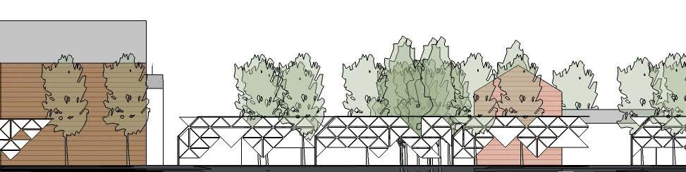
2 ARKKITEHTUURIN TIEDEKUNTA ARKKITEHTUURIN HISTORIA JA KORJAUSSUUNNITTELU RAKENNUSSUOJELU JA RAKENNETUN YMPÄRISTÖ HOITO 2017 OPISKELIJAT Iris Ammann Svenja Dürr Jenni Hakovirta Hertta Hjelt Nelly Isopahkala Illusia Leskinen Jari Maukonen Laura Metsi Laura Mustonen Anna-Elisabet Määttä Kristian Paavilainen Chiara Terenzi Kuva 4 Havainnekuva A Konseptin soveltaminen Kuva 4 Paikkoja mahdollisille sovlluksille Oulun kaupunki kehittää jatkuvasti keskustan alueella kaupunginojan ympäristöä erityisesti valaistuksen ja yleisen viihtyvyyden kautta. Kehitysalue kuitenkin päättyy Rautatienkatuun. Pidemmälle jatkettaessa ojaa on vaikea edes seurailla, je se kulkee paikoitellen hyvin umpeenkasvaneilla alueilla. Osittain sen varrella kulkee virkistysreittejä. Tuomalla yhteisöllistä siirtolapuutarhahenkistä rakentamista kaupunginojan varteen, rannat aktivoituisivat paitsi asukkaiden niin myös muiden kaupunkilaisten käyttöön.vaihtelevat maisemat ja elämä kohottaisivat ojan virkistysarvoa. Paikoitellen oja kapenee hyvinkin kapeaksi, mutta on siitä huolimatta arvokas ja hieno elementti, jota ei ole hyödynnetty juurikaan. Karttaan on merkitty esimerkkialueita joilla Castreninrannan konseptin tyyppistä rakentamista voitaisiin hyödyntää. Kulkuyhteydet ja muut maankäytön kysymykset vaatisivat lisäselvityksiä RAKENNUSSUOJELU JA RAKENNETUN YMPÄRISTÖN HOITO RAKSILA OULU 2017 GSEducationalVersion OPETTAJAT Anna-Maija Ylimaula Özlem Özer-Kemppainen Kari Niskasaari Juho Teppo YHTEISVILJELY TUTKIJA Sara Porzilli KATTOPUUTARHA Oulu 2017 ISBN ISSN HERTTA HJELT 5

3 8 SARA PORZILLI
4 LASER SCANNING SURVEY OF THE STREET FACADES IN RAKSILA Ratakatu, Syrjäkatu, Puutarhakatu, Karjakatu, Puistikkokatu Researcher: Ph.D. Arch. Sara Porzilli Assistant: Francesca Messeri RAKENNUSSUOJELU JA RAKENNETUN YMPÄRISTÖN HOITO RAKSILA OULU 2017 SARA PORZILLI 9

5 LASER SCANNER SURVEY as a method for documenting the townscape Laser scanning technology represents nowadays one of the most efàcient type of survey for measuring and documenting architecture and its environment in general. Cities and urban spaces are in fact growing and changing so quickly that urban planners and experts have the necessities to update their technical tools for monitoring these continuos events. This necessity appears even more relevant and urgent for those urban expansions which involve historic archictural realities as Raksila represents. This scientiàc report shows in fact that even if a small distric-area as Raksila appears almost regular and simple in its main features, in its reality it is determinated by thousands of sensible differences and important elements which constitute the image and the identity of the place. A detailed analysis like the one shown in the report demonstrate that only through methodological analysis and combined activities, as for example survey and photo documentation, we can discover the key points for preserving the authenticity of the townscape. Investigations, census activities, inventory catalogues, digital 3D survey database and true metrical information are fundamental in order to understand the formation and development of an architectural entity, village, or city, as well as for planning conservation and restoration projects starting from the present state of a building or distric. Thanks to these information it s possible to recognize the tangible and intagible elements which constitute the genius loci of the place (C. Norberg-Schulz, Genius loci towards a phenomenology of architecture) for determinating helpful guidelines for the townscape. The survey of Raksila has involved the architecture and its main environment as two essential parts of the same research topic. Below some 3D visualizations and post productions results (as for example digital maps and street sections) are shown in order to demonstrate which can be the main results and outputs achieva ble from these kind of operations. The laser scanner survey of Raksila has been developed thanks to the European Project of PhD. Arch. Sara Porzilli, PostDoc Fellow of the University of Oulu. Title of the research is Preserving Wooden Heritage. Methods for monitoring wooden structures: 3D laser scanner survey and application of BIM systems on point cloud models 1 and it concerns the application of digital survey systems for preserving wooden architecture in order to get updated methods for monitoring this precious type of heritage. Detail of the project: European Commission Horizon 2020 Research and Innovation 1 Framework Programme. MARIE SKáODOWSKA-CURIE ACTIONS INDIVIDUAL FELLOWSHIP. Call: H2020-MSCA-IF ScientiÀc Panel: ST-ENG. Duration of the Project: 24 months. ScientiÀc Coordinator and Supervisor is Prof. Anna-Maija Ylimaula. Project results are protected by the Marie Skâodowska Curie grant agreement of the Researcher Phd. Sara Porzilli. The equipment used has been provided by Mitta Oy, ofàcial partner of the project. 10 SARA PORZILLI

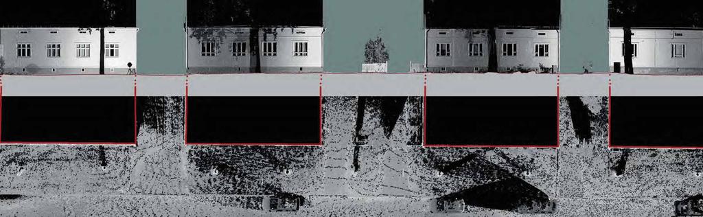
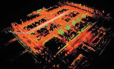
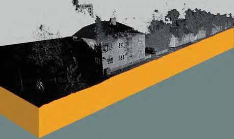
6 THE SURVEY PROJECT: scan positions and resolution of the point cloud mt The survey of Raksila has involved the main streets of the area in order to get a general but detailed recognition of the place with its main measures, including both the architecture and the environment. The laser scanner used is one of the latest Zoller + Fröhlich laser scanner, 5010 model. Streets surveyed are: - Ratakatu (speci cally the part of the bus stop parking area considered the entrance part to Raksila area). 3 ScanStations with SUPERHIGH resolution; - Syrjäkatu. 17 ScanStations in HIGH Resolution; - Puutarhakatu. 29 ScanStations in HIGH Resolution; - Karjakatu. 14 ScanStations in HIGH Resolution; - Puistikkokatu. 21 ScanStations in HIGH Resolution; - Tehtaankatu. 7 ScanStations in SUPERHIGH Resolution. Survey of the part of street between Syrjäkatu and Karjakatu; - Teuvo Pakkalan Katu. 4 ScanStations in SUPERHIGH Resolution. The scans wanted to survey the facade of the old School and close the perimeter of Puistikkokatu street; - Kainuuntie. 6 ScanStations in SUPERHIGH Resolution, in order to get the main measures of the street and the opposite site of the river for a general recognition of the distance of Karjasilta side. Because for the large dimension of the area and because for the presence of the tree crowns still present at the moment of the survey, it has been fundamental to plan a dense project of scan positions. A precise organization of the scan-positions has been de ned in advance in order to set the practical activities and quantify the amount of necessary work on eld. This operation is sensibly recommended because it gives a real and practical understanding of the work and obligates the surveyor to elaborate in advance all the necessary work strategies useful for carrying out the results. In addition to this, strategic scan positions made with superhigh resolution has given the possibility to obtain a more accurate result and achieve a better compensation of the geometrical error. As underlined in the image always groups of three ScanStations are located whenever possible in an equilateral triangle position in order to keep their mutual angle orientations not over 60 degrees. This operation gives the possibility in post production phase to handle and combine the singular point clouds produced with the minimum level of error. The survey project had the role to measure the street fronts trying to obtain the maximum information of the facades of the buildings avoiding the tree crowns when possible. Thanks to this product it has been possible to elaborate accurate street sections in both trasversal and longitudinal orientation RAKENNUSSUOJELU JA RAKENNETUN YMPÄRISTÖN HOITO RAKSILA OULU 2017 SARA PORZILLI 11


7 REGISTRATION OF THE POINT CLOUD AND FINAL METRIC DATABASE The survey project has been registered by using the Z+F Laser Control Software which allows you to see all the scanwords done in a top view mode directly on the map generated and gives you the possibility to recognize each singular scan position and navigate in it (with a double click on the blue sphere). Thanks to this software the nal point cloud has a negligible presence of mistake. Each block is located in the right position in relation to the rest of the area. All the facades from the street side have a detailed point cloud. Thanks to the superhigh scans it has been possible to acquire far distances and hights as for example the high buildings in Ratakatu and Syriäkatu. In order to elaborate the sections the metric database has been divided in sub-categories, corresponding with the streets scanned. 12 SARA PORZILLI
8 RAKENNUSSUOJELU JA RAKENNETUN YMPÄRISTÖN HOITO RAKSILA OULU 2017 SARA PORZILLI 13

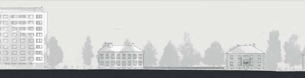
9 PUUTARHAKATU 14 SARA PORZILLI

10 mt Longitudinal section of Puutarhakatu mt Detail of the street section of Puutarhakatu RAKENNUSSUOJELU JA RAKENNETUN YMPÄRISTÖN HOITO RAKSILA OULU 2017 SARA PORZILLI 15

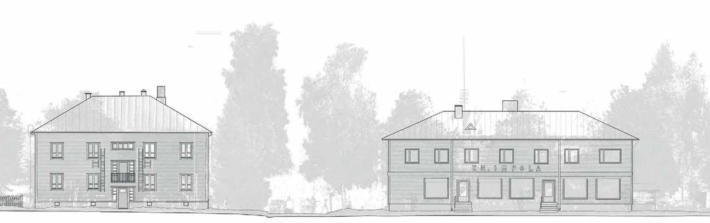
11 KARJAKATU 16 SARA PORZILLI

12 mt Longitudinal section of Karjakatu mt Detail of the street section of Karjakatu RAKENNUSSUOJELU JA RAKENNETUN YMPÄRISTÖN HOITO RAKSILA OULU 2017 SARA PORZILLI 17
13 PUISTIKKOKATU 18 SARA PORZILLI


14 mt Street section of Puistikkokatu mt Detail of the street section of Puistikkokatu RAKENNUSSUOJELU JA RAKENNETUN YMPÄRISTÖN HOITO RAKSILA OULU 2017 SARA PORZILLI 19
An Undergraduate Project with Terrestrial Laser Scanner for Purpose of Architectural Survey
 Theory and Application of Laser Scanning ISPRS Summer School 2007 Ljubljana,Slovenia An Undergraduate Project with Terrestrial Laser Scanner for Purpose of Architectural Survey Cemal Özgür KIVILCIM ISPRS
Case Study. How we build reality. Company Overview. Effi cient Geometric Documentation of Buildings: Castle Schloss Johannisburg, Aschaffenburg
 How we build reality Case Study Effi cient Geometric Documentation of Buildings: Castle Schloss Johannisburg, Aschaffenburg Company Overview Z+F is one of the world s leading manufacturers in the fi eld
MEÄN SAUNA Inventory of old smoke saunas in the Swedish Torne river valley using laser scanning and photogrammetry.
 MEÄN SAUNA Inventory of old smoke saunas in the Swedish Torne river valley using laser scanning and photogrammetry. Olle Hagman Sara Porzilli Markku Seppänen Mats Winsa The cultural heritage of the Swedish
How we build reality. Company Overview. Effi cient Geometric Documentation of Buildings: Castle Schloss Johannisburg in
 How we build reality Effi cient Geometric Documentation of Buildings: Castle Schloss Johannisburg in Case Study Aschaffenburg Company Overview Z+F is one of the world s leading manufacturers in the fi
Digital Preservation of the Aurelius Church and the Hirsau Museum Complex by Means of HDS and Photogrammetric Texture Mapping
 Master Thesis Ruxandra MOROSAN Ruxandra MOROSAN Digital Preservation of the Aurelius Church and the Hirsau Museum Complex by Means of HDS and Photogrammetric Texture Mapping Duration of the Thesis: 6 months
Case Study. How we build reality. Company Overview. Estimating mass properties of dinosaurs using laser imaging and 3D computer modeling
 How we build reality Case Study Estimating mass properties of dinosaurs using laser imaging and 3D computer modeling Company Overview Z+F is the world leader in the manufacturer of phase based laser scanners.
Cultural Heritage. Geometric Recording of Cultural Monuments. Basic Principles of Geometric Recording. Specific requirements
 LOW COST DIGITAL PHOTOGRAMMETRIC TECHNIQUES FOR THE DOCUMENTATION OF CULTURAL HERITAGE Ch. Ioannidis, S. Soile, C. Potsiou Lab. of Photogrammetry School of Rural & Surveying Eng. National Technical University
Semi-Automatic Techniques for Generating BIM Façade Models of Historic Buildings
 Semi-Automatic Techniques for Generating BIM Façade Models of Historic Buildings C. Dore, M. Murphy School of Surveying & Construction Management Dublin Institute of Technology Bolton Street Campus, Dublin
Geospatial database for heritage building conservation
 IOP Conf. Series: Earth and Environmental Science 18 (2014) 012087 doi:10.1088/1755-1315/18/1/012087 Geospatial database for heritage building conservation W N F W A Basir1,3, H Setan1, Z M ajid1, A Chong2
II. FIELD STUDIES 3D SCANNING
 Non-Invasive Data Collecting from 3D Laser Scanning of Objects Covered by the Historic Buildings Conservation Plan, for The Purpose of Their Restoration Joanna A. Pawłowicz, Elżbieta Szafranko Faculty
The Institute of Remote Sensing and Digital Earth, Chinese Academy of Sciences liqi
 Fine Deformation Monitoring of Ancient Building Based on Terrestrial Laser Scanning Technologies The Institute of Remote Sensing and Digital Earth, Chinese Academy of Sciences liqi Outline Introduce the
USE THE 3D LASER SCANNING FOR DOCUMENTATION THE RIGA CATHEDRAL IN LATVIA
 USE THE 3D LASER SCANNING FOR DOCUMENTATION THE RIGA CATHEDRAL IN LATVIA Maris Kalinka, Elina Rutkovska, Department of Geomatic, Riga Technical University, Azenes 16-109, Riga, Latvia, geomatika@geomatika.lv
Geometric Accuracy Investigations of the Latest Terrestrial Laser Scanning Systems
 Thomas Kersten, Klaus Mechelke, Maren Lindstaedt, Harald Sternberg Geometric Accuracy Investigations of the Latest Terrestrial Laser Scanning Systems Outline of presentation Introduction Laser scanning
Framework for HBIM Applications in Egyptian Heritage
 BUE ACE1 Sustainable Vital Technologies in Engineering & Informatics 8-10 Nov 2016 Framework for HBIM Applications in Egyptian Heritage Mohamed Marzouk a, *, Mahmoud Metawie b, and Mohamed Ali b a Professor
3D SPATIAL DATA ACQUISITION AND MODELING OF ANGHEL SALIGNY MONUMENT USING TERRESTRIAL LASER SCANNING
 JOURNAL OF APPLIED ENGINEERING SCIENCES VOL. 2(15), issue 2_2012 ISSN 2247-3769 ISSN-L 2247-3769 (Print) / e-issn:2284-7197 3D SPATIAL DATA ACQUISITION AND MODELING OF ANGHEL SALIGNY MONUMENT USING TERRESTRIAL
INTEGRATION OF POINT CLOUDS DATASET FROM DIFFERENT SENSORS
 INTEGRATION OF POINT CLOUDS DATASET FROM DIFFERENT SENSORS C.K.A.F. Che Ku Abdullah, N.Z.S Baharuddin, M.F.M. Ariff, Z. Majid, C.L. Lau, A.R. Yusoff, K.M. Idris, A. Aspuri Department of Geoinformation,
How we build reality. Company Overview. Case Study Stonehenge in High Defi nition
 How we build reality Case Study Stonehenge in High Defi nition Company Overview Z+F is one of world leading manufacturers of phase based laser scanners. Our strengths lie in our powerful 3D laser scanning
Digital Softcopy Photogrammetry
 LLP Erasmus IP EPOCHE 2013 Thassos Island, Greece, 2-16 June 2013 Digital Softcopy Photogrammetry Prof. Levente DIMEN The 1 Decembrie 1918 University of Alba Iulia, Romania GENERAL CONTEXT In the last
Reality Capture. Customer Case
 Reality Capture Customer Case Reality Capture customer case: MP-Map Oy Surveying company using FARO laser scanners MP-Map Oy is a construction surveying company with over 30 years of surveying experience
A Procedure for accuracy Investigation of Terrestrial Laser Scanners
 A Procedure for accuracy Investigation of Terrestrial Laser Scanners Sinisa Delcev, Marko Pejic, Jelena Gucevic, Vukan Ogizovic, Serbia, Faculty of Civil Engineering University of Belgrade, Belgrade Keywords:
Laser Scanning. 3D Model is not existing and is required for: studies revamping maintenance HSE integration in another 3D model archiving
 Laser Scanning Laser Scanning Laser scanning is used whenever: 3D Model is not existing and is required for: studies revamping maintenance HSE integration in another 3D model archiving 2 Object acquisition
LASER SCANNING SUPPORTS ARCHITECTURAL MAPPINGS AND HISTORICAL URBAN VIEW ANALYSIS
 LASER SCANNING SUPPORTS ARCHITECTURAL MAPPINGS AND HISTORICAL URBAN VIEW ANALYSIS Daniela ORENI*, Francesco FASSI**, Raffaella BRUMANA**, Federico PRANDI**, Hande TUNCER** * DIAP - Politecnico di Milano
AUTOMATED 3D MODELING OF URBAN ENVIRONMENTS
 AUTOMATED 3D MODELING OF URBAN ENVIRONMENTS Ioannis Stamos Department of Computer Science Hunter College, City University of New York 695 Park Avenue, New York NY 10065 istamos@hunter.cuny.edu http://www.cs.hunter.cuny.edu/
Artescan, 3D Scanning IPN TecBis, Edif. E Rua Pedro Nunes, Coimbra, Portugal
 1 Displacement and surface pathology monitoring of former Tejo Power Station building by combining terrestrial laser scanning, micro-geodesy, photogrammetry and GIS Adriano OLIVEIRA, João BOAVIDA, Bruno
IDENTIFICATION DEFORMATION AREAS OF SLOPS USING TERRESTRIAL LASER
 IDENTIFICATION DEFORMATION AREAS OF SLOPS USING TERRESTRIAL LASER SCANNER PRELIMINARY RESEARCH Bartłomiej Ćmielewski 1 Abstract The identification of the deformation of superficial objects, not monolithic,
A new geodetic methodology for the accurate Documentation and Monitoring of inaccessible surfaces.
 A new geodetic methodology for the accurate Documentation and Monitoring of inaccessible surfaces. Ε. Lambrou, G. Pantazis Lecturers at NTUA School of Rural and Surveying Engineering National Technical
THE USE OF OPTICAL METHODS FOR LEAK TESTING DAMPERS
 DAAAM INTERNATIONAL SCIENTIFIC BOOK 2013 pp. 787-794 CHAPTER 47 THE USE OF OPTICAL METHODS FOR LEAK TESTING DAMPERS TOMASIAK, J. Abstract: The present paper presents the possible use of a portable structural
BIM-based software tool for BIPV systems design + simulation. Philippe ALAMY. CADCAMation Project Manager
 BIM-based software tool for BIPV systems design + simulation Philippe ALAMY CADCAMation Project Manager palamy@cadcamation.ch BIM-based software tool for BIPV systems design + simulation Introduction BIM-based
Task group 9 GENERIC TEMPLATE FOR THE MANAGEMENT OF HERITAGE PLACES
 Task group 9 GENERIC TEMPLATE FOR THE MANAGEMENT OF HERITAGE PLACES INVOLVED USER: Guliz Bilgin METU Faculty of Architecture ANKARA PROVIDER: Fulvio Rinaudo DITAG Politecnico di Torino Objectives To FILL
Efficient and Effective Quality Assessment of As-Is Building Information Models and 3D Laser-Scanned Data
 Efficient and Effective Quality Assessment of As-Is Building Information Models and 3D Laser-Scanned Data Pingbo Tang 1, Engin Burak Anil 2, Burcu Akinci 2, Daniel Huber 3 1 Civil and Construction Engineering
Unwrapping of Urban Surface Models
 Unwrapping of Urban Surface Models Generation of virtual city models using laser altimetry and 2D GIS Abstract In this paper we present an approach for the geometric reconstruction of urban areas. It is
THE COLORED COMPARISON OF THE WALL SCULPTURE WITH 3D LASER SCANNER AND ORTHOPHOTO
 THE COLORED COMPARISON OF THE WALL SCULPTURE WITH 3D LASER SCANNER AND ORTHOPHOTO Hirotoshi KURASHIGE, Jun KATO, Shozo NISHIMURA Creative Department, Keisoku Research Consultant Co, 1-665-1 Fukuda, Higashi-ku,
TERRESTRIAL LASER SCANNER TECHNIC AS A METHOD FOR IDENTIFICATION AREAS OF SLOPS
 77 TERRESTRIAL LASER SCANNER TECHNIC AS A METHOD FOR IDENTIFICATION AREAS OF SLOPS Bartłomiej Ćmielewski, Bernard Kontny Institute of Geodesy and Geoinformatics, Wroclaw University of Environmental and
Terrestrial 3D laser scanning Practical aspects
 Terrestrial 3D laser scanning Practical aspects ISPRS WG VI/5&SC Summer School 2007 by Gregor Bilban 3D laser scanning Benefits Lower data collection costs Reduction or elimination of re-visits More accurate
Small or. Collaborative. Polito D7.1. Submission Due Nature R D. Project. Tel: +39 Fax: +39
 Small or medium scale focused research project (STREP) FP7 SMARTCITIES 2013 ICT 2013.6.4 Optimizing Energy Systems in Smart Cities District Information Modeling and Management for Energy Reduction Project
A New Approach for Façade Documentation Using Laser Scanner
 Australian Journal of Basic and Applied Sciences, 5(5): 1080-1085, 2011 ISSN 1991-8178 A New Approach for Façade Documentation Using Laser Scanner 1 Ahmed K. Abdel-Gawwad and 2 Yasser M. El-Sherbiny 1,2
A 130 Year- Old Story
 A 130 Year- Old Story The Architectural Survey of the Hungarian State Opera CÉH Inc. of Budapest, Hungary was tasked with the enormous task of measuring and modeling the Hungarian State Opera House. The
Built Heritage 2013 Monitoring Conservation Management
 From video sequence as a database for the generation of 3D models to video as a tool for architecture communication Matteo Flavio Mancini; Alessia Moscarelli; Erald Mulla Sapienza Università di Roma, Facoltà
LiForest Software White paper. TRGS, 3070 M St., Merced, 93610, Phone , LiForest
 0 LiForest LiForest is a platform to manipulate large LiDAR point clouds and extract useful information specifically for forest applications. It integrates a variety of advanced LiDAR processing algorithms
Photogrammetry and 3D Car Navigation
 Photogrammetric Week '07 Dieter Fritsch (Ed.) Wichmann Verlag, Heidelberg, 2007 Strassenburg-Kleciak 309 Photogrammetry and 3D Car Navigation MAREK STRASSENBURG-KLECIAK, Hamburg ABSTRACT The technological
Advanced Highway Maintenance and Construction Technology Research Center
 Advanced Highway Maintenance and Construction Technology Research Center Department of Mechanical and Aerospace Engineering University of California at Davis Creating Standards and Specifications for the
VISUALIZATION OF FRESCOS BY MEANS OF PHOTOGRAMMETRY AND LASER SCANNING
 VISUALIZATION OF FRESCOS BY MEANS OF PHOTOGRAMMETRY AND LASER SCANNING E. Stylianidis a, P. Patias a, C. Liapakis b, V. Balis b, G. Philotheou c a The Aristotle University of Thessaloniki, Department of
The Trimble 3D Scanning Solution: Designed by Surveyors for Surveyors
 The Trimble 3D Scanning Solution: Designed by Surveyors for Surveyors TRIMBLE 3D SCANNING Designed by surveyors for surveyors, the Trimble 3D scanning solution follows the surveying workflow you re familiar
TERRESTRIAL LASER SCANNER DATA PROCESSING
 TERRESTRIAL LASER SCANNER DATA PROCESSING L. Bornaz (*), F. Rinaudo (*) (*) Politecnico di Torino - Dipartimento di Georisorse e Territorio C.so Duca degli Abruzzi, 24 10129 Torino Tel. +39.011.564.7687
2D-based Indoor Mobile Laser Scanning for Construction Digital Mapping Application with BIM
 Presented at the FIG Congress 2018, May 6-11, 2018 in Istanbul, Turkey 2D-based Indoor Mobile Laser Scanning for Construction Digital Mapping Application with BIM Chao CHEN Llewellyn TANG Craig M HANCOCK
The Processing of Laser Scan Data for the Analysis of Historic Structures in Ireland
 The 7th International Symposium on Virtual Reality, Archaeology and Cultural Heritage VAST (2006) M. Ioannides, D. Arnold, F. Niccolucci, K. Mania (Editors) The Processing of Laser Scan Data for the Analysis
Urban Social Networks
 Urban Social Networks Sensing, Modelling and Visualising Urban Mobility and Copresence Networks Vassilis Kostakos Madeira Interactive Technologies Institute University of Madeira Motivation Slide 2 Motivation
INTEGRATION OF TREE DATABASE DERIVED FROM SATELLITE IMAGERY AND LIDAR POINT CLOUD DATA
 INTEGRATION OF TREE DATABASE DERIVED FROM SATELLITE IMAGERY AND LIDAR POINT CLOUD DATA S. C. Liew 1, X. Huang 1, E. S. Lin 2, C. Shi 1, A. T. K. Yee 2, A. Tandon 2 1 Centre for Remote Imaging, Sensing
Introduction. Advanced Econometrics - HEC Lausanne. Christophe Hurlin. University of Orléans. October 2013
 Advanced Econometrics - HEC Lausanne Christophe Hurlin University of Orléans October 2013 Christophe Hurlin (University of Orléans) Advanced Econometrics - HEC Lausanne October 2013 1 / 27 Instructor Contact
Bridging the gap between 5G and B5G
 5G-MiEdge Bridging the gap between 5G and B5G Valerio Frascolla Director Research and Innovation at Intel 07.03.2018 SPEED-5G WS on Advanced spectrum management in 5G+ networks, London 1 5G-MiEdge EU-JP
THE ETRUSCANS IN 3D: FROM SPACE TO UNDERGROUND
 THE ETRUSCANS IN 3D: FROM SPACE TO UNDERGROUND Fabio Remondino 1, Alessandro Rizzi 1, Belen Jimenez 1, Giorgio Agugiaro 1, Giorgio Baratti 1, Raffaele De Amicis 2 (1) 3D Optical Metrology (3DOM) Bruno
Methods for Automatically Modeling and Representing As-built Building Information Models
 NSF GRANT # CMMI-0856558 NSF PROGRAM NAME: Automating the Creation of As-built Building Information Models Methods for Automatically Modeling and Representing As-built Building Information Models Daniel
From Cadastres to Urban Environments for 3D Geomarketing
 From Cadastres to Urban Environments for 3D Geomarketing Martin Hachet and Pascal Guitton Abstract-- This paper presents tools performing automatic generation of urban environments for 3D geomarketing.
Indoor. Heritage Preservation CAD versus Cloud. inside. Applanix and CSIRO. Grows with LiDAR. Vol. 2 Issue 4 ABOVE & BEYOND. ipad & Tablet Ready!
 inside Indoor Mapping Applanix and CSIRO SMALL BUSINESS Grows with LiDAR Heritage Preservation CAD versus Cloud Vol. 2 Issue 4 ABOVE & BEYOND ipad & Tablet Ready! RE-MODELING THE MIXMASTER From Mobile
FULL AUTOMATIC REGISTRATION OF LASER SCANNER POINT CLOUDS
 FULL AUTOMATIC REGISTRATION OF LASER SCANNER POINT CLOUDS Devrim Akca Institute of Geodesy and Photogrammetry, ETH - Zurich, Switzerland http://www.photogrammetry.ethz.ch 1 The Goal: is automatic registration
Drones and Supercalculators : A New Field of Investigation in Photogrammetry.
 1 Drones and Supercalculators : A New Field of Investigation in Photogrammetry. The Rise in Popularity of Applications and Performances. Introduction... p. 2 Archeology... p. 3 National Heritage Sites
Robust Automatic 3D Point Cloud Registration and Object Detection
 FEATURE EXTRACTION FOR BIM Robust Automatic 3D Point Cloud Registration and Object Detection BY DAVID SELVIAH This article presents a ground-breaking approach to generating survey data for a BIM process
Italian pavilion in 3D, project for EXPO 2015, Milan (Italy) JRC 3D RECONSTRUCTOR POWERFUL. ADVANCED. PROFESSIONAL
 JRC 3D RECONSTRUCTOR POWERFUL. ADVANCED. PROFESSIONAL") Italian pavilion in 3D, project for EXPO 2015, Milan (Italy) JRC 3D RECONSTRUCTOR POWERFUL. ADVANCED. PROFESSIONAL OVERVIEW JRC 3D Reconstructor is the well known multi-platform and multi-resolution software
Italian pavilion in 3D, project for EXPO 2015, Milan (Italy) JRC 3D RECONSTRUCTOR POWERFUL. ADVANCED. PROFESSIONAL OVERVIEW JRC 3D Reconstructor is the well known multi-platform and multi-resolution software
D7.8 Brochure, Poster and e-newsletters 1
 Grant Agreement No. 727721 Contract Duration: 40 months (1 st November 2016 29th February 2020) This project is funded by The European Union H2020-SC1-2016-CNECT SC1-PM-18-2016 - Big Data Supporting Public
THE STANDARD OF MANAGEMENT AND APPLICATION OF CULTURAL HERITAGE DOCUMENTATION
 THE STANDARD OF MANAGEMENT AND APPLICATION OF CULTURAL HERITAGE DOCUMENTATION YEN YA NING 1, WENG KUO HUA 2, CHENG HUNG MING 3, HSU WEI SHAN 4 China University of Technology, 1 Faculty of Architecture,
Terrestrial Laser Scanning for underground marble quarry planning: Comparison of multi-temporal 3D point clouds
 Terrestrial Laser Scanning for underground marble quarry planning: Comparison of multi-temporal 3D point clouds Oliveti M., Mastrorocco G., Esposito G., Di Bartolo S., Seddaiu M., Rindinella A., Salvini
3D IN GIS. 1. Presentation of the results of the scientific and technical contents
 G. Nagy, A. Szepes 3D in GIS 3D IN GIS NAGY Gábor, assistant professor, University of West Hungary, Faculty of Geoinformatics, Department of GIS, ng@geo.info.hu SZEPES András, associate professor, University
LEARNING KIT AND TUTORIALS FOR THE DIFFUSION OF THE DIGITAL PHOTOGRAMMETRY
 LEARNING KIT AND TUTORIALS FOR THE DIFFUSION OF THE DIGITAL PHOTOGRAMMETRY Elena ALBERY *, Andrea LINGUA *, Paolo MASCHIO * * Politecnico di Torino, Italia Dipartimento di Georisorse e Territorio Albery@vdiget.polito.it,
APPLICATION OF 3D TERRESTRIAL LASER SCANNING IN THE PROCESS OF UPDATE OR CORRECTION OF ERRORS IN THE CADASTRAL MAP
 Presented at the FIG Working Week 2017, May 29 - June 2, 2017 in Helsinki, Finland Dr.-Eng. Gintcho Kostov GEO ZEMIA Ltd. 1 1. Introduction 3D Terrestrial laser scanning delivers highly accurate spatial
Reality Capture using: RPAS Technologies & Image Laser Scanners
 Reality Capture using: RPAS Technologies & Image Laser Scanners by Johan Erasmus (RPAS Technologies) & Barend Bornman (Image Laser Scanners) from Aciel Geomatics Laser Scanners High-Definition Surveying
Draper Aden VIRTUAL CONSTRUCTION DOCUMENT, DESIGN, AND BUILD IN 3D
 VIRTUAL CONSTRUCTION VIRTUAL CONSTRUCTION The design and construction environment has changed. While the goals of completing a project on time, within budget, and at the expected level of quality remain
Comparing Aerial Photogrammetry and 3D Laser Scanning Methods for Creating 3D Models of Complex Objects
 Comparing Aerial Photogrammetry and 3D Laser Scanning Methods for Creating 3D Models of Complex Objects A Bentley Systems White Paper Cyril Novel Senior Software Engineer, Bentley Systems Renaud Keriven
Polygon scanner based ultra-short pulse laser processing in roll-to-roll manufacturing
 Polygon scanner based ultra-short pulse laser processing in roll-to-roll manufacturing Development of high speed ultra-short pulse laser ablation process integrated into a roll-to-roll machine Name Surname,
Bosch Measuring Tools Software Partners
 Bosch Measuring Tools Software Partners Introduction We currently place excellent measuring tools on the market, working with well-designed apps for Android and ios devices, bringing connectivity to life
Comparing Aerial Photogrammetry and 3D Laser Scanning Methods for Creating 3D Models of Complex Objects
 www.bentley.com Comparing Aerial Photogrammetry and 3D Laser Scanning Methods for Creating 3D Models of Complex Objects A Bentley White Paper Cyril Novel Senior Software Engineer, Bentley Systems Renaud
INTEGRATING PHOTOGRAMMETRIC TECHNOLOGIES AND GEODETIC METHODS FOR 3D MODELING
 INTEGRATING PHOTOGRAMMETRIC TECHNOLOGIES AND GEODETIC METHODS FOR 3D MODELING Georgeta Pop Faculty of Geodesy, Geodesy and Photogrammetry Department, Technical University of Civil Engineering Bucharest,
Using virtual reality to teach history
 Using virtual reality to teach history Calin Neamtu 1, Radu Comes 1, Razvan Mateescu 2, Rares Ghinea 1, Filip Daniel 1 (1) Department of Design Engineering and Robotics, Technical University of Cluj-Napoca,
DESCRIBING FOREST STANDS USING TERRESTRIAL LASER-SCANNING
 DESCRIBING FOREST STANDS USING TERRESTRIAL LASER-SCANNING T. Aschoff a, *, M. Thies a, H. Spiecker a a Institute for Forest Growth, University of Freiburg, Tennenbacherstr. 4, D-79106 Freiburg, Germany
A TRUST-BY-DESIGN FRAMEWORK FOR THE INTERNET OF THINGS
 A TRUST-BY-DESIGN FRAMEWORK FOR THE INTERNET OF THINGS ESR3 - Davide Ferraris PhD Student @ University of Malaga, NICS lab Tutors: Prof. Javier Lopez, Dr. Carmen Fernandez Gago 1 Contents Introduction
AR Cultural Heritage Reconstruction Based on Feature Landmark Database Constructed by Using Omnidirectional Range Sensor
 AR Cultural Heritage Reconstruction Based on Feature Landmark Database Constructed by Using Omnidirectional Range Sensor Takafumi Taketomi, Tomokazu Sato, and Naokazu Yokoya Graduate School of Information
Next Steps. Investing in the Future of. MASTER DEVELOPER PROCUREMENT OVERVIEW October 2016 July Chicago Union Station Chicago Union Station
 Investing in the Future of Chicago Union Station Chicago Union Station MASTER DEVELOPER PROCUREMENT OVERVIEW October 2016 July 2015 Next Steps 1 Chicago Union Station Operations 4 th busiest station in
METADATA MANAGEMENT AND STATISTICAL BUSINESS PROCESS AT STATISTICS ESTONIA
 Distr. GENERAL 06 May 2013 WP.13 ENGLISH ONLY UNITED NATIONS ECONOMIC COMMISSION FOR EUROPE CONFERENCE OF EUROPEAN STATISTICIANS EUROPEAN COMMISSION STATISTICAL OFFICE OF THE EUROPEAN UNION (EUROSTAT)
3D Laser Scanning Approaches and Business Models for implementing BIM in Facility Management
 3D Laser Scanning Approaches and Business Models for implementing BIM in Facility Management M.Sc. Zsuzsa Besenyői, HTW Berlin Prof. Dr.-Ing. Markus Krämer, HTW Berlin Dipl.-Ing. (FH) Frank Lindner, G2Plus
Data Management Plan
 Data Management Plan Mark Sanders, Martina Chýlková Document Identifier D1.9 Data Management Plan Version 1.0 Date Due M6 Submission date 30 November, 2015 WorkPackage WP1 Management and coordination Lead
PAST, PRESENT & FUTURE: Using Digital Technologies to Support Conservation. (photogrammetry vs. laser scanning)
") PAST, PRESENT & FUTURE: Using Digital Technologies to Support Conservation (photogrammetry vs. laser scanning) Dr Eujin Pei and Anthony Eland School of Design, De Montfort University Introduction Project
PAST, PRESENT & FUTURE: Using Digital Technologies to Support Conservation (photogrammetry vs. laser scanning) Dr Eujin Pei and Anthony Eland School of Design, De Montfort University Introduction Project
STUDY ON INFORMATION MANAGEMENT FOR THE CONSERVATION OF TRADITIONAL CHINESE ARCHITECTURAL HERITAGE 3D MODELLING AND METADATA REPRESENTATION
 STUDY ON INFORMATION MANAGEMENT FOR THE CONSERVATION OF TRADITIONAL CHINESE ARCHITECTURAL HERITAGE 3D MODELLING AND METADATA REPRESENTATION Ya.Ning,Yen a Kuo.Hua,Weng b Hui.Yu, Huang c a Associate Professor,China
Terrestrial radar and laser scanning for deformation monitoring: first steps towards assisted radar scanning
 Terrestrial radar and laser scanning for deformation monitoring: first steps towards assisted radar scanning Daniel Wujanz 1, Frank Neitzel 1, H.P. Hebel 2, J. Linke 2, W. Busch 2 1 Chair of Geodesy and
High Definition Modeling of Calw, Badstrasse and its Google Earth Integration
 Master Thesis Yuanting LI High Definition Modeling of Calw, Badstrasse and its Google Earth Integration Duration of the Thesis: 6 months Completion: July, 2014 Supervisors: Prof.Dr.-Ing.Dieter Fritsch
With FARO PointSense for Revit. Jörg Braunes Platform Owner Software Chris Palmer Sales Engineer 1
 From Point Clouds to BIM Models With FARO PointSense for Revit Jörg Braunes Platform Owner Software Chris Palmer Sales Engineer 1 Agenda Scan to BIM with Revit PointClouds in Revit Advanced Workflow with
A COMPARISON OF SPARSE AND DENSE POINT APPROACH TO PHOTOGRAMMETRIC 3D MODELING FOR STONE TEXTURED OBJECTS (CASE STUDY: ARCHEOLOGICAL SITES) ABSTRACT
 ABSTRACT") A COMPARISON OF SPARSE AND DENSE POINT APPROACH TO PHOTOGRAMMETRIC 3D MODELING FOR STONE TEXTURED OBJECTS (CASE STUDY: ARCHEOLOGICAL SITES) Arnadi D. Murtiyoso 1, Deni Suwardhi 2 1,2 Spatial Information
A COMPARISON OF SPARSE AND DENSE POINT APPROACH TO PHOTOGRAMMETRIC 3D MODELING FOR STONE TEXTURED OBJECTS (CASE STUDY: ARCHEOLOGICAL SITES) Arnadi D. Murtiyoso 1, Deni Suwardhi 2 1,2 Spatial Information
Delivering the value of BIM to Smart Mobile Devices
 UCL CEGE Geomatic Delivering the value of BIM to Smart Mobile Devices Capturing 3D Geometry for BIM (Scan2BIM) Dietmar Backes, Charles Thomson, Stuart McLeod, Prof Stuart Robson, Dr Jan Boehm, Dr David
Case Study. How we build reality. Company Overview. High-end 3D processes at the Bavarian State Criminal Police Offi ce (BLKA)
") How we build reality Case Study High-end 3D processes at the Bavarian State Criminal Police Offi ce (BLKA) Company Overview Z+F is one of the world s leading manufacturers in the fi eld of non-contact
How we build reality Case Study High-end 3D processes at the Bavarian State Criminal Police Offi ce (BLKA) Company Overview Z+F is one of the world s leading manufacturers in the fi eld of non-contact
Hassle-free banking in the DIGITAL AGE through NEXT-GEN. Technologies W H I T E PA P E R
 Hassle-free banking in the DIGITAL AGE through NEXT-GEN Technologies W H I T E PA P E R Experience smooth transactions with the new generation of banking and payments using facial recognition. Financial
Terrestrial Laser Scanning in Building Documentation
 Civil Engineering and Architecture 5(6): 215-221, 2017 DOI: 10.13189/cea.2017.050603 http://www.hrpub.org Terrestrial Laser Scanning in Building Documentation Aikaterini Karagianni Laboratory of Photogrammetry-Remote
THE USE OF TERRESTRIAL LASER SCANNING IN THE RENOVATION OF HISTORIC BUILDINGS
 THE USE OF TERRESTRIAL LASER SCANNING IN THE RENOVATION OF HISTORIC BUILDINGS Eleftherios Tournas, Maria Tsakiri National Technical University of Athens, School of Rural and Surveying Engineering, 9, Iroon
Coordinating Optimisation of Complex Industrial Processes
 Ref. Ares(2016)7192906-29/12/2016 Coordinating Optimisation of Complex Industrial Processes COCOP Project information Project call H2020-SPIRE-2016 Grant Number 723661 Project duration 1.10.2016-31.3.2020
CASOB Simultaneous Surveying and Drawing
 CASOB Simultaneous Surveying and Drawing Michael Korte adiplan Bauvermessung München/Germany ecaade 1991 - PDF-Proceedings (conversion 2000) 261 Michael Korte, CASOB 1 Accurate planning and economical
AUTOMATIC EXTRACTION OF BUILDING FEATURES FROM TERRESTRIAL LASER SCANNING
 AUTOMATIC EXTRACTION OF BUILDING FEATURES FROM TERRESTRIAL LASER SCANNING Shi Pu and George Vosselman International Institute for Geo-information Science and Earth Observation (ITC) spu@itc.nl, vosselman@itc.nl
Grant Name: Development of Inter-Agency Rare Species Data Sharing and Exchange for Statewide Wildlife Conservation Planning.
 Grant Name: Development of Inter-Agency Rare Species Data Sharing and Exchange for Statewide Wildlife Conservation Planning. We created a digital repository of nearly 200 reports and data sets containing
CSc Topics in Computer Graphics 3D Photography
 CSc 83010 Topics in Computer Graphics 3D Photography Tuesdays 11:45-1:45 1:45 Room 3305 Ioannis Stamos istamos@hunter.cuny.edu Office: 1090F, Hunter North (Entrance at 69 th bw/ / Park and Lexington Avenues)
High Resolution Tree Models: Modeling of a Forest Stand Based on Terrestrial Laser Scanning and Triangulating Scanner Data
 ELMF 2013, 11-13 November 2013 Amsterdam, The Netherlands High Resolution Tree Models: Modeling of a Forest Stand Based on Terrestrial Laser Scanning and Triangulating Scanner Data Lothar Eysn Lothar.Eysn@geo.tuwien.ac.at
MODELING CITY HALL S FAÇADE USING LASER SCANNING TECHNOLOGY
 Преглед НЦД 15 (2009), 59 63 Vladimir Pajić, Dušan Jovanović Miro Govedarica (Faculty of Technical Sciences, Novi Sad, Serbia) MODELING CITY HALL S FAÇADE USING LASER SCANNING TECHNOLOGY Abstract. This
X-PAD Ultimate. The Ultimate solution in the field. Works when you do
 Works when you do X-PAD Ultimate The Ultimate solution in the field X-PAD Ultimate is a tailored, flexible, modular, ideal, customised software for high end topographic tasks, such as measure, stake-out,
IoT CoAP Plugtests & Workshop November 27 th 2012
 Building the Environment for the Things as a Service IoT CoAP Plugtests & Workshop November 27 th 2012 Introduction The BETaaS FP7 project Facts Start date: 1/10/12 End date: 31/3/15 (30 months) Cost:
Training in Mapping Changes on an Archaeological Site
 Training in Mapping Changes on an Archaeological Site Presented at the FIG Congress 2018, May 6-11, 2018 in Istanbul, Turkey Pierre-Yves Gilliéron Bertrand Merminod Jérôme Zufferey EPFL Presentation 04.2015