CALIPSO Version 3 Data Products: Additions and Improvements
|
|
|
- Anne Quinn
- 6 years ago
- Views:
Transcription

1 CALIPSO Version 3 Data Products: Additions and Improvements Dave Winker and the CALIPSO team CALIPSO/CloudSat Science Team Meeting July, Madison, WI 1
2 Version 3 Status Version 3 algorithms now used for Level 1 forward processing Starting from turn-on of CALIOP backup laser Reprocessing with Version 3 Level 1 to begin soon All mission data to be reprocessed, from 7 June 2006 Version 3 algorithms for Level 2 processing in final testing Profile products restructured Numerous algorithm improvements Significant bugs fixed All mission data to be reprocessed, probably from 13 June
3 Version 3 Data Products: Level 1 Level 1 data processed using Version 3 algorithms since March 2009 Calibration improvements Goal for calibration uncertainty, radiometric stability: 5% Improved 532 nm daytime calibration > 30 km Rayleigh calibration can only be done at night > Daytime uncertainties improved from 10% to 5% > Stratospheric aerosol biases not yet corrected 1064 nm calibration: significant biases remain > Initial approach using cirrus targets determined to be unreliable > Investigating new approaches (sea surface, etc.) 3
 8-12 km, clear-air attenuated scattering")
4 Improved daytime 532 calibration Version 3 daytime calibration Version 2 daytime calibration Version 1 daytime calibration (using previous nighttime mean calibration) 8-12 km, clear-air attenuated scattering ratios: 4
5 1064: calibration biases remain from cirrus backscatter: X 1064 /X 532 from ocean surface backscatter: X 532 /X Latitude Magnitude and details of biases are seasonally dependent 5
6 Version 3 Data Products: Level 2 New parameters added Aerosol and cloud profile products restructured and improved Aerosol now reported at 5 km Many added parameters Data quality flags now included Algorithm Improvements: Revised strategy for extinction retrievals boundary layer aerosol, constrained cirrus retrievals 1064 nm lidar ratio for dust changed from 30 to 50 New cloud ice/water phase algorithm Several significant bug fixes 6
7 Added Level 2 Parameters Column optical depth in aerosol and cloud layer and profile products Shape parameter (ice clouds) Classification of ice habit: plate-like, column-like, irregular, and oriented Based on algorithm of Noel (2002, 2004, 2006) Cloud-fraction parameter added to 5-km layer and profile products Orbit and path numbers Cloud base, mid, top pressure Cloud base and top temperature Uncertainties now provided for most parameters 7
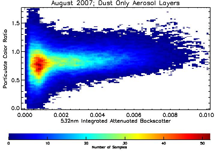
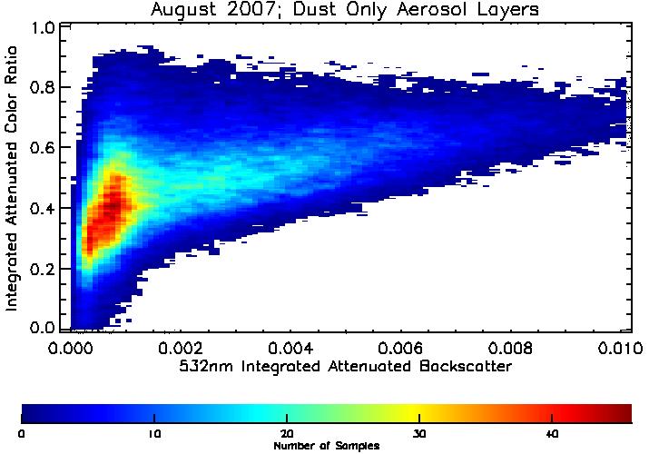
8 Added Parameters: χ p χ p vs IAB χ vs IAB 8


9 Added Parameters: δ p δ p vs IAB δ p vs δ V 9
10 Added parameters: IWP, IWC Cloud profile product: Ice Water Content Cloud layer product: Ice Water Path g/m 3 10
11 Restructured Profile Products Version 2: Profiles of aerosol and cloud 532 and 1064 extinction and backscatter only Cloud profiles reported at 5 km Aerosol profiles averaged to 40 km Both aerosol and cloud profiles now reported at 5-km horizontal resolution Still retrieved at km Added profiles: 532 nm perpendicular backscatter and particle depolarization Atmospheric Volume Description (cloud/aerosol/clear etc.) Cloud fraction within the 5-km horizontal grid Backscatter and extinction uncertainties Added column parameters: Column optical depth: cloud, aerosol, stratosphere Column integrated attenuated backscatter (IAB) Added data quality information CAD score Ext_QC flag Feature type QA flags 11
12 Algorithm Improvements Revisions to constrained extinction retrieval strategy Version 2: constrained retrievals not applied to any cloud or aerosol layer detected on more than one pass through the detection loop This requirement relaxed in Version 3: more constrained retrievals, primarily for nighttime cirrus Revised retrievals of boundary layer aerosol Version 2: extinction only retrieved within detected layers Version 3: extinction retrieved from top of lowest aerosol layer to the surface 1064 nm lidar ratio for dust changed from 30 sr to 50 sr With the revised boundary layer retrieval strategy, will increase column AOD in dust regions New ice-water phase algorithm 12


13 Revised boundary layer aerosol retrieval 532 nm Attenuated Backscatter HSRL V3-alpha V nm Attenuated Backscatter Vertical Feature Mask 13
 (Yong Hu, et al.")
14 New Ice-Water Phase Algorithm Oriented crystals HOI water water ROI random ice IAB δ (Yong Hu, et al., Optics Express, 2007) (Yong Hu, et al., JTech, 2009) 14


15 Reduced artifacts in cloud ice-water phase Oriented ice now properly classified (HOI water in V2) Version 2.01 Version 3 Number of ice clouds with tops below 3.25 km 15
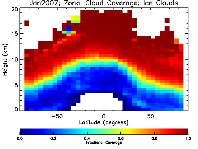
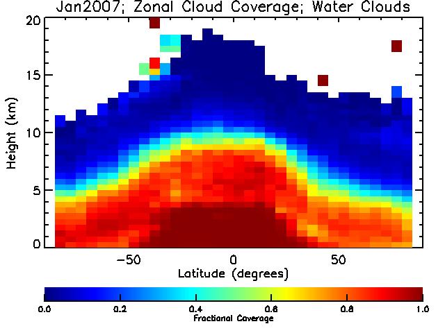

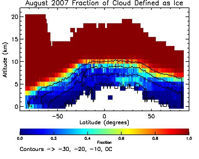
16 Zonal fractions: ice cloud water cloud V3 (Aug) V2 (Jan) 16 16
17 Bug Fixes Surface detection more reliable, especially in 1/3 km product Bugs in surface detection algorithms caused low marine clouds to be sometimes classified as ocean surface Other times, surface detections were underreported Handling of multiple scattering corrected Version 2: multiple scattering corrections applied incorrectly to constrained retrievals (4% of cirrus in Version 2) Multiple scattering corrections not propagated to lower layers Clearing of boundary layer cloud Fix has biggest impacts in marine trade cumulus regions 17


18 Bug in boundary layer cloud clearing In Version 2, clouds below 4 km not cleared properly Cloud-contaminated aerosol classified as cloud Cloud-clearing scheme fixed in Version 3 18


19 CALIPSO layer detection scheme Remove Clouds from boundary layerat single shot resolution Use Profile Scanning Engine to locate features at 1-km and 1/3-km High Resolution Cl ou d Cl ea r i n g Average Data in troposphere to 1-km horizontal resolution NO Boundary layer cleared? YES layer detection algorithm applies a special cloudclearing scheme below 4 km to retrieve boundary layer aerosol Average Data to horizontal resolution K Use Profile Scanning Engine to locate features at resolution K K = 1? Set K = K+1 M ulti-resolution Layer Detection NO YES Remove Layers Apply Attenuation Correction NO K = N? YES Write Level II Data Products 19


20 Trade cumulus scene V2.01 cloud aerosol V3 (correct) 20 20


21 Improved low-cloud statistics Version 2.01 Global mean cover of singlelayer low cloud reduced from 26.1% to 21.8% Regional reductions as much as a factor of 5. Version 3-alpha test 21
 CALIPSO (24.")

22 ISCCP vs. CALIPSO ISCCP (25.1%) CALIPSO (24.0%) Low clouds (Single-layer low clouds, except high clouds with OD < 3 ignored) June-August


23 Next steps Further improvements to calibration Use multiple consistency checks to improve 1064 nm calibration Improve aerosol AOD/extinction retrievals using ocean surface returns accurate AOD/cloud screening on single shots no microphysical assumptions Standard CALIPSO AOD vs. MODIS AOD from ocean sfc returns (D. Josset) 23
Aeolus L2A optical properties products and assimilation in air quality models
 Aeolus L2A optical properties products and assimilation in air quality models Thomas Flament, Angela Benedetti, P. Martinet, E. Martins, L. El Amraoui, A. Dabas, P. Flamant Toulouse, 28 March 2017 Aladin,
Aerosol Remote Sensing from PARASOL and the A-Train
 Aerosol Remote Sensing from PARASOL and the A-Train J.-F. Léon, D. Tanré, J.-L. Deuzé, M. Herman, P. Goloub, P. Lallart Laboratoire d Optique Atmosphérique, France A. Lifermann Centre National d Etudes
Using LiDAR for Classification and
 Using LiDAR for Classification and Recognition of Particulate Matter in the Atmosphere M. Elbakary, K. Iftekharuddin, and K. AFRIFA ECE Dept., Old Dominion University, Norfolk, VA Outline Goals of the
DELIVERABLE 2 SPECIALIZED NOVEL SOFTWARE FOR THE ACQUISITION AND ANALYSIS OF 6 DIFFERENT LIDAR SIGNALS IN REAL TIME
 DELIVERABLE 2 SPECIALIZED NOVEL SOFTWARE FOR THE ACQUISITION AND ANALYSIS OF 6 DIFFERENT LIDAR SIGNALS IN REAL TIME Project Title : Development of a 6-wavelength LIDAR system for the retrieval of the microphysical
The University of Wisconsin Arctic High-Spectral Resolution Lidar: General Information and Data Examples
 The University of Wisconsin Arctic High-Spectral Resolution Lidar: General Information and Data Examples Gijs de Boer, Edwin Eloranta The University of Wisconsin Madison, Madison, WI USA 1. Introduction
Cirrus optical depth and lidar ratio retrieval from combined CALIPSO-CloudSat observations using ocean surface echo
 Cirrus optical depth and lidar ratio retrieval from combined CALIPSO-CloudSat observations using ocean surface echo Damien Josset, Jacques Pelon, Anne Garnier, Yongxiang Hu, Mark Vaughan, Peng-Wang Zhai,
OCEANSAT-2 OCEAN COLOUR MONITOR (OCM-2)
") OCEANSAT-2 OCEAN COLOUR MONITOR (OCM-2) Update of post launch vicarious, lunar calibrations & current status Presented by Prakash Chauhan Space Applications Centre Indian Space Research Organistaion Ahmedabad-
OCEANSAT-2 OCEAN COLOUR MONITOR (OCM-2) Update of post launch vicarious, lunar calibrations & current status Presented by Prakash Chauhan Space Applications Centre Indian Space Research Organistaion Ahmedabad-
ATLAS ATLID Algorithms and Level 2 System Aspects
 ATLAS ATLID Algorithms and Level 2 System Aspects Contract No 22638/09/NL/CT ATBD Page 1 of 25 Issue 1.3 ATLAS ATLID Algorithms and Level 2 System Aspects Algorithm Theoretical Basis Document (ATBD) for
Extension of the CREWtype Analysis to VIIRS. Andrew Heidinger, Andi Walther, Yue Li and Denis Botambekov NOAA/NESDIS and UW/CIMSS, Madison, WI, USA
 Extension of the CREWtype Analysis to VIIRS Andrew Heidinger, Andi Walther, Yue Li and Denis Botambekov NOAA/NESDIS and UW/CIMSS, Madison, WI, USA CREW-4 Grainau, Germany, March 2014 Motivation Important
Level 2 Radar-Lidar GEOPROF Product VERSION 1.0 Process Description and Interface Control Document
 Recommendation JPL Document No. D-xxxx CloudSat Project A NASA Earth System Science Pathfinder Mission Level 2 Radar-Lidar GEOPROF Product VERSION 1.0 Process Description and Interface Control Document
Global and Regional Retrieval of Aerosol from MODIS
 Global and Regional Retrieval of Aerosol from MODIS Why study aerosols? CLIMATE VISIBILITY Presented to UMBC/NESDIS June 4, 24 Robert Levy, Lorraine Remer, Yoram Kaufman, Allen Chu, Russ Dickerson modis-atmos.gsfc.nasa.gov
UV Remote Sensing of Volcanic Ash
 UV Remote Sensing of Volcanic Ash Kai Yang University of Maryland College Park WMO Inter-comparison of Satellite-based Volcanic Ash Retrieval Algorithms Workshop June 26 July 2, 2015, Madison, Wisconsin
Refinement of global ice microphysics using spaceborne active sensors
 JOURNAL OF GEOPHYSICAL RESEARCH, VOL. 116,, doi:10.1029/2011jd015885, 2011 Refinement of global ice microphysics using spaceborne active sensors Kaori Sato 1 and Hajime Okamoto 1 Received 28 February 2011;
The effect of specular reflection on spaceborne lidar measurements of ice clouds
 The effect of specular reflection on spaceborne lidar measurements of ice clouds ROBIN J. HOGAN AND ANTHONY J. ILLINGWORTH Department of Meteorology, University of Reading, United Kingdom Report for the
Improvements to the SHDOM Radiative Transfer Modeling Package
 Improvements to the SHDOM Radiative Transfer Modeling Package K. F. Evans University of Colorado Boulder, Colorado W. J. Wiscombe National Aeronautics and Space Administration Goddard Space Flight Center
Summary of Publicly Released CIPS Data Versions.
 Summary of Publicly Released CIPS Data Versions. Last Updated 13 May 2012 V3.11 - Baseline data version, available before July 2008 All CIPS V3.X data versions followed the data processing flow and data
GOES-R AWG Radiation Budget Team: Absorbed Shortwave Radiation at surface (ASR) algorithm June 9, 2010
 algorithm June 9, 2010") GOES-R AWG Radiation Budget Team: Absorbed Shortwave Radiation at surface (ASR) algorithm June 9, 2010 Presented By: Istvan Laszlo NOAA/NESDIS/STAR 1 ASR Team Radiation Budget AT chair: Istvan Laszlo ASR
GOES-R AWG Radiation Budget Team: Absorbed Shortwave Radiation at surface (ASR) algorithm June 9, 2010 Presented By: Istvan Laszlo NOAA/NESDIS/STAR 1 ASR Team Radiation Budget AT chair: Istvan Laszlo ASR
Aerosol profiling by combination of lidar and lunar/star-photometry
 Aerosol profiling by combination of lidar and lunar/star-photometry Lucas Alados Arboledas (Task 11.2), UGR CNR, CNRS, UGR, UNIVLEEDS ACTRIS-2 1 st WP3 Workshop Athens, Greece November 10-12, 2015 Task
Claus Weitkamp Editor. Lidar. Range-Resolved Optical Remote Sensing of the Atmosphere. Foreword by Herbert Walther. With 162 Ulustrations.
 Claus Weitkamp Editor Lidar Range-Resolved Optical Remote Sensing of the Atmosphere Foreword by Herbert Walther With 162 Ulustrations 4Q Springer Contents Foreword Preface List of Contributors v vii xix
* Attending the Science Team Meeting
 GSFC Steve Platnick (PI), Kerry Meyer U. Wisconsin/CIMSS Steve Ackerman, Rich Frey*, Andy Heidinger [NOAA], Andi Walther * Attending the Science Team Meeting U. Colorado/LASP - Odele Coddington*, Peter
Lecture 13.1: Airborne Lidar Systems
 Lecture 13.1: Airborne Lidar Systems 1. Introduction v The main advantages of airborne lidar systems are that they expand the geographical range of studies beyond those possible by surface-based fixed
NASA e-deep Blue aerosol update: MODIS Collection 6 and VIIRS
 NASA e-deep Blue aerosol update: MODIS Collection 6 and VIIRS Andrew M. Sayer, N. Christina Hsu (PI), Corey Bettenhausen, Nick Carletta, Jaehwa Lee, Colin Seftor, Jeremy Warner Past team members: Ritesh
Implementation of Version 6 AQUA and TERRA SST processing. K. Kilpatrick, G. Podesta, S. Walsh, R. Evans, P. Minnett University of Miami March 2014
 Implementation of Version 6 AQUA and TERRA SST processing K. Kilpatrick, G. Podesta, S. Walsh, R. Evans, P. Minnett University of Miami March 2014 Outline of V6 MODIS SST changes: A total of 3 additional
Physical Modeling for Processing Geosynchronous Imaging Fourier Transform Spectrometer (GIFTS) Indian Ocean METOC Imager (IOMI) Hyperspectral Data
 Indian Ocean METOC Imager (IOMI) Hyperspectral Data") University of Wisconsin - Madison (UW) University of Hawaii (UH) Texas A& M (TAMU) University of Colorado at Boulder (CU) University of Alabama in Huntsville (UAH) MURI Physical Modeling for Processing
University of Wisconsin - Madison (UW) University of Hawaii (UH) Texas A& M (TAMU) University of Colorado at Boulder (CU) University of Alabama in Huntsville (UAH) MURI Physical Modeling for Processing
TES Algorithm Status. Helen Worden
 TES Algorithm Status Helen Worden helen.m.worden@jpl.nasa.gov Outline TES Instrument System Testing Algorithm updates One Day Test (ODT) 2 TES System Testing TV3-TV19: Interferometer-only thermal vacuum
Dennis L. Hlavka* and Stephen P. Palm Science Systems and Applications, Inc NASA/Goddard Space Flight Center, Greenbelt, Maryland
 P1.13 COLUMN OPTICAL DEPTH RETRIEVAL USING SURFACE REFLECTIVITY FROM GLAS Dennis L. Hlavka* and Stephen P. Palm Science Systems and Applications, Inc NASA/Goddard Space Flight Center, Greenbelt, Maryland
EarthCARE The Earth Cloud Aerosol and Radiation Explorer
 EarthCARE The Earth Cloud Aerosol and Radiation Explorer STATUS Tobias Wehr (1) and Riko Oki (2) (1) ESA/ESTEC, Noordwijk, The Netherlands (2) JAXA/EORC, Tsukuba, Ibaraki, Japan CloudSAT & CALIPSO Science
Improved MODIS Aerosol Retrieval using Modified VIS/MIR Surface Albedo Ratio Over Urban Scenes
 Improved MODIS Aerosol Retrieval using Modified VIS/MIR Surface Albedo Ratio Over Urban Scenes Min Min Oo, Matthias Jerg, Yonghua Wu Barry Gross, Fred Moshary, Sam Ahmed Optical Remote Sensing Lab City
Overview of Atmospheric Radiative Transfer. Sergio De Souza-Machado, L. Larrabee Strow, Scott Hannon, Howard Motteler
 Overview of Atmospheric Radiative Transfer Sergio De Souza-Machado, L. Larrabee Strow, Scott Hannon, Howard Motteler U M B C UNIVERSITY OF MARYLAND BALTIMORE COUNTY 1 9 6 6 Workshop for Soundings from
Performance assessment of a five-channel estimation-based ice cloud retrieval scheme for use over the global oceans
 Click Here for Full Article JOURNAL OF GEOPHYSICAL RESEARCH, VOL. 112,, doi:10.1029/2006jd007122, 2007 Performance assessment of a five-channel estimation-based ice cloud retrieval scheme for use over
Comparison of Full-resolution S-NPP CrIS Radiance with Radiative Transfer Model
 Comparison of Full-resolution S-NPP CrIS Radiance with Radiative Transfer Model Xu Liu NASA Langley Research Center W. Wu, S. Kizer, H. Li, D. K. Zhou, and A. M. Larar Acknowledgements Yong Han NOAA STAR
Lecture 24. Lidar Simulation
 Lecture 24. Lidar Simulation q Introduction q Lidar Modeling via Lidar Simulation & Error Analysis q Functions of Lidar Simulation and Error Analysis q How to Build up Lidar Simulation? q Range-resolved
Understanding The MODIS Aerosol Products
 Understanding The MODIS Aerosol Products Rich Kleidman Science Systems and Applications Rob Levy Science Systems and Applications Lorraine Remer NASA Goddard Space Flight Center Chistina Chu NASA Goddard
OMAERO README File. Overview. B. Veihelmann, J.P. Veefkind, KNMI. Last update: November 23, 2007
 OMAERO README File B. Veihelmann, J.P. Veefkind, KNMI Last update: November 23, 2007 Overview The OMAERO Level 2 data product contains aerosol characteristics such as aerosol optical thickness (AOT), aerosol
Improved representation of marine stratocumulus clouds and. the anthropogenic aerosol effect IACETH
 Improved representation of marine stratocumulus clouds and the anthropogenic aerosol effect D. Neubauer, U. Lohmann, C. Hoose, G. M. Frontoso ETH-Zurich EGU General Assembly 2014, 1 May 2014, Vienna Typical
Retrievals of Profiles of Fine and Coarse Aerosols Using Lidar and Radiometric Space Measurements
 IEEE TRANSACTIONS ON GEOSCIENCE AND REMOTE SENSING, VOL. 41, NO. 8, AUGUST 2003 1743 Retrievals of Profiles of Fine and Coarse Aerosols Using Lidar and Radiometric Space Measurements Yoram J. Kaufman,
Evaluation of Several A-Train Ice Cloud Retrieval Products with In Situ Measurements Collected during the SPARTICUS Campaign
 1014 J O U R N A L O F A P P L I E D M E T E O R O L O G Y A N D C L I M A T O L O G Y VOLUME 52 Evaluation of Several A-Train Ice Cloud Retrieval Products with In Situ Measurements Collected during the
Multi-sensors vicarious calibration activities at CNES
 Multi-sensors vicarious calibration activities at CNES Patrice Henry, Bertrand Fougnie June 11, 2013 CNES background in image quality monitoring of operational Earth observation systems Since the launch
S2 MPC Data Quality Report Ref. S2-PDGS-MPC-DQR
 S2 MPC Data Quality Report Ref. S2-PDGS-MPC-DQR 2/13 Authors Table Name Company Responsibility Date Signature Written by S. Clerc & MPC Team ACRI/Argans Technical Manager 2015-11-30 Verified by O. Devignot
User Manual. Program to generate atmospheric backscatter and attenuation coefficients using BACKSCAT 4.0 / LOWTRAN 7 aerosol models.
 User Manual Program to generate atmospheric backscatter and attenuation coefficients using BACKSCAT 4.0 / LOWTRAN 7 aerosol models. Distributed by: Ontar Corporation 9 Village Way North Andover, MA 01845-2000
DISCRIMINATING CLEAR-SKY FROM CLOUD WITH MODIS ALGORITHM THEORETICAL BASIS DOCUMENT (MOD35) MODIS Cloud Mask Team
 MODIS Cloud Mask Team") DISCRIMINATING CLEAR-SKY FROM CLOUD WITH MODIS ALGORITHM THEORETICAL BASIS DOCUMENT (MOD35) MODIS Cloud Mask Team Steve Ackerman 1, Kathleen Strabala 1, Paul Menzel 1,2, Richard Frey 1, Chris Moeller 1,
DISCRIMINATING CLEAR-SKY FROM CLOUD WITH MODIS ALGORITHM THEORETICAL BASIS DOCUMENT (MOD35) MODIS Cloud Mask Team Steve Ackerman 1, Kathleen Strabala 1, Paul Menzel 1,2, Richard Frey 1, Chris Moeller 1,
ERAD Proceedings of ERAD (2002): c Copernicus GmbH 2002
: c Copernicus GmbH 2002") Proceedings of ERAD (22): 179 183 c Copernicus GmbH 22 ERAD 22 An enhanced algorithm for the retrieval of liquid water cloud properties from simultaneous radar and lidar measurements. Part II: Validation
Proceedings of ERAD (22): 179 183 c Copernicus GmbH 22 ERAD 22 An enhanced algorithm for the retrieval of liquid water cloud properties from simultaneous radar and lidar measurements. Part II: Validation
Direct radiative forcing of aerosol
 Direct radiative forcing of aerosol 1) Model simulation: A. Rinke, K. Dethloff, M. Fortmann 2) Thermal IR forcing - FTIR: J. Notholt, C. Rathke, (C. Ritter) 3) Challenges for remote sensing retrieval:
JAXA Himawari Monitor Aerosol Products. JAXA Earth Observation Research Center (EORC) September 2018
 September 2018") JAXA Himawari Monitor Aerosol Products JAXA Earth Observation Research Center (EORC) September 2018 1 2 JAXA Himawari Monitor JAXA has been developing Himawari-8 products using the retrieval algorithms
JAXA Himawari Monitor Aerosol Products JAXA Earth Observation Research Center (EORC) September 2018 1 2 JAXA Himawari Monitor JAXA has been developing Himawari-8 products using the retrieval algorithms
Important Notes on the Release of FTS SWIR Level 2 Data Products For General Users (Version 02.xx) June, 1, 2012 NIES GOSAT project
 June, 1, 2012 NIES GOSAT project") Important Notes on the Release of FTS SWIR Level 2 Data Products For General Users (Version 02.xx) June, 1, 2012 NIES GOSAT project 1. Differences of processing algorithm between SWIR L2 V01.xx and V02.xx
Important Notes on the Release of FTS SWIR Level 2 Data Products For General Users (Version 02.xx) June, 1, 2012 NIES GOSAT project 1. Differences of processing algorithm between SWIR L2 V01.xx and V02.xx
Reprocessing of Suomi NPP CrIS SDR and Impacts on Radiometric and Spectral Long-term Accuracy and Stability
 Reprocessing of Suomi NPP CrIS SDR and Impacts on Radiometric and Spectral Long-term Accuracy and Stability Yong Chen *1, Likun Wang 1, Denis Tremblay 2, and Changyong Cao 3 1.* University of Maryland,
Light Scattering by Preferentially Oriented Ice Crystals
 PIERS ONLINE, VOL. 5, NO. 5, 009 401 Light Scattering by Preferentially Oriented Ice Crystals A. Borovoi and N. Kustova Institute of Atmospheric Optics, Rus. Acad. Sci., Tomsk, Russia Abstract Scattered
Synergistic cloud retrievals from radar, lidar and radiometers
 Synergistic cloud retrievals from radar, lidar and radiometers Robin Hogan Julien Delanoë, Nicola Pounder, Nicky Chalmers, Thorwald Stein, Anthony Illingworth University of Reading Spaceborne radar, lidar
SST Retrieval Methods in the ESA Climate Change Initiative
 ESA Climate Change Initiative Phase-II Sea Surface Temperature (SST) www.esa-sst-cci.org SST Retrieval Methods in the ESA Climate Change Initiative Owen Embury Climate Change Initiative ESA Climate Change
JAXA Himawari Monitor Aerosol Products. JAXA Earth Observation Research Center (EORC) August 2018
 August 2018") JAXA Himawari Monitor Aerosol Products JAXA Earth Observation Research Center (EORC) August 2018 1 JAXA Himawari Monitor JAXA has been developing Himawari 8 products using the retrieval algorithms based
JAXA Himawari Monitor Aerosol Products JAXA Earth Observation Research Center (EORC) August 2018 1 JAXA Himawari Monitor JAXA has been developing Himawari 8 products using the retrieval algorithms based
arxiv: v3 [math.oc] 20 Jun 2016
![arxiv: v3 [math.oc] 20 Jun 2016](/thumbs/95/125391801.jpg "arxiv: v3 [math.oc] 20 Jun 2016") A New Approach to Inverting Backscatter and Extinction from Photon-Limited Lidar Observations Willem J. Marais 1,2,, Robert E. Holz 2, Yu Hen Hu 1, Ralph E. Kuehn 2, Edwin E. Eloranta 3, and Rebecca M.
A New Approach to Inverting Backscatter and Extinction from Photon-Limited Lidar Observations Willem J. Marais 1,2,, Robert E. Holz 2, Yu Hen Hu 1, Ralph E. Kuehn 2, Edwin E. Eloranta 3, and Rebecca M.
Evolution of DARDAR-CLOUD ice cloud retrievals: new parameters and impacts on the retrieved microphysical properties
 Evolution of DARDAR-CLOUD ice cloud retrievals: new parameters and impacts on the retrieved microphysical properties Quitterie Cazenave 1,2, Marie Ceccaldi 1, Julien Delanoë 1, Jacques Pelon 3, Silke Groß
Menghua Wang NOAA/NESDIS/STAR Camp Springs, MD 20746, USA
 Ocean EDR Product Calibration and Validation Plan Progress Report: VIIRS Ocean Color Algorithm Evaluations and Data Processing and Analyses Define a VIIRS Proxy Data Stream Define the required in situ
Direct Remote Measurement of Mixed Layer Using Lidar
 Direct Remote Measurement of Mixed Layer Using Lidar Gary Spiers -JPL, Paul von Allmen JPL Dimitris Menemenlis- JPL Julian A. Domaradzki USC Tyler Schlenker- SpaceX Darek Bogucki Department of Physical
Lecture 09. Lidar Simulation and Error Analysis Overview (1)
") Lecture 09. Lidar Simulation and Error Analysis Overview (1) Introduction Lidar Modeling via Lidar Simulation & Error Analysis Functions of Lidar Simulation and Error Analysis How to Build up Lidar Simulation?
Lecture 09. Lidar Simulation and Error Analysis Overview (1) Introduction Lidar Modeling via Lidar Simulation & Error Analysis Functions of Lidar Simulation and Error Analysis How to Build up Lidar Simulation?
RECENT ADVANCES IN THE SCIENCE OF RTTOV. Marco Matricardi ECMWF Reading, UK
 RECENT ADVANCES IN THE SCIENCE OF RTTOV Marco Matricardi ECMWF Reading, UK RTTOV is the NWP SAF fast radiative transfer model and is developed jointly by ECMWF, the Met Office and Météo France. In this
GAW Aerosol Lidar Observation Network (GALION)
") GAW Aerosol Lidar Observation Network (GALION) First WMO Experts Meeting on the implementation of the GAW Aerosol Lidar Observation Network: GALION Held in March 2007, Hamburg Germany 2008 WMO Report:
GAW Aerosol Lidar Observation Network (GALION) First WMO Experts Meeting on the implementation of the GAW Aerosol Lidar Observation Network: GALION Held in March 2007, Hamburg Germany 2008 WMO Report:
Suomi NPP CrIS Reprocessed SDR Long-term Accuracy and Stability
 Suomi NPP CrIS Reprocessed SDR Long-term Accuracy and Stability Yong Chen 1, Yong Han, Likun Wang 1, Fuzhong Weng, Ninghai Sun, and Wanchun Chen 1 CICS-MD, ESSIC, University of Maryland, College Park,
MODIS Atmosphere: MOD35_L2: Format & Content
 Page 1 of 9 File Format Basics MOD35_L2 product files are stored in Hierarchical Data Format (HDF). HDF is a multi-object file format for sharing scientific data in multi-platform distributed environments.
Evaluation of Satellite Ocean Color Data Using SIMBADA Radiometers
 Evaluation of Satellite Ocean Color Data Using SIMBADA Radiometers Robert Frouin Scripps Institution of Oceanography, la Jolla, California OCR-VC Workshop, 21 October 2010, Ispra, Italy The SIMBADA Project
Retrieval of optical and microphysical properties of ocean constituents using polarimetric remote sensing
 Retrieval of optical and microphysical properties of ocean constituents using polarimetric remote sensing Presented by: Amir Ibrahim Optical Remote Sensing Laboratory, The City College of the City University
Retrieval of Cirrus Cloud Radiative and Backscattering Properties Using Combined Lidar and Infrared Radiometer (LIRAD) Measurements
 Measurements") 1658 JOURNAL OF ATMOSPHERIC AND OCEANIC TECHNOLOGY VOLUME 18 Retrieval of Cirrus Cloud Radiative and Backscattering Properties Using Combined Lidar and Infrared Radiometer (LIRAD) Measurements JENNIFER
1658 JOURNAL OF ATMOSPHERIC AND OCEANIC TECHNOLOGY VOLUME 18 Retrieval of Cirrus Cloud Radiative and Backscattering Properties Using Combined Lidar and Infrared Radiometer (LIRAD) Measurements JENNIFER
Hyperspectral Remote Sensing
 Hyperspectral Remote Sensing Multi-spectral: Several comparatively wide spectral bands Hyperspectral: Many (could be hundreds) very narrow spectral bands GEOG 4110/5100 30 AVIRIS: Airborne Visible/Infrared
Validation of MODTRAN 5.3 sea surface radiance computations
 Validation of MODTRAN 5.3 sea surface radiance computations Vincent Ross*, Denis Dion** et Daniel St-Germain** * With AEREX Avionique Inc., ** With DRDC Valcartier ITBM&S, Toulouse France. June 27th 211
Improved Global Ocean Color using POLYMER Algorithm
 Improved Global Ocean Color using POLYMER Algorithm François Steinmetz 1 Didier Ramon 1 Pierre-Yves Deschamps 1 Jacques Stum 2 1 Hygeos 2 CLS June 29, 2010 ESA Living Planet Symposium, Bergen, Norway c
SINGLE FOOTPRINT ALL-SKY RETRIEVALS USING A FAST, ACCURATE TWOSLAB CLOUD REPRESENTATION
 SINGLE FOOTPRINT ALL-SKY RETRIEVALS USING A FAST, ACCURATE TWOSLAB CLOUD REPRESENTATION Sergio DeSouza-Machado, Larrabee Strow Department of Physics, JCET University of Maryland Baltimore County (UMBC)
Interactive comment on Quantification and mitigation of the impact of scene inhomogeneity on Sentinel-4 UVN UV-VIS retrievals by S. Noël et al.
 Atmos. Meas. Tech. Discuss., www.atmos-meas-tech-discuss.net/5/c741/2012/ Author(s) 2012. This work is distributed under the Creative Commons Attribute 3.0 License. Atmospheric Measurement Techniques Discussions
Interactive comment on Quantification and mitigation of the impact of scene inhomogeneity on Sentinel-4 UVN UV-VIS retrievals by S. Noël et al.
 Atmos. Meas. Tech. Discuss., 5, C741 C750, 2012 www.atmos-meas-tech-discuss.net/5/c741/2012/ Author(s) 2012. This work is distributed under the Creative Commons Attribute 3.0 License. Atmospheric Measurement
A Sensitivity Study of the Effect of Horizontal Photon Transport on the Radiative Forcing of Contrails
 1706 J O U R N A L O F T H E A T M O S P H E R I C S C I E N C E S VOLUME 64 A Sensitivity Study of the Effect of Horizontal Photon Transport on the Radiative Forcing of Contrails AMANDA GOUNOU AND ROBIN
Shortwave Flux from Satellite-Measured Radiance: A Theoretical Study over Marine Boundary Layer Clouds
 2144 JOURNAL OF APPLIED METEOROLOGY VOLUME 4 Shortwave Flux from Satellite-Measured Radiance: A Theoretical Study over Marine Boundary Layer Clouds L. H. CHAMBERS AND B. A. WIELICKI Atmospheric Sciences,
2017 Summer Course on Optical Oceanography and Ocean Color Remote Sensing. Introduction to Remote Sensing
 2017 Summer Course on Optical Oceanography and Ocean Color Remote Sensing Introduction to Remote Sensing Curtis Mobley Delivered at the Darling Marine Center, University of Maine July 2017 Copyright 2017
Daytime Cloud Overlap Detection from AVHRR and VIIRS
 Daytime Cloud Overlap Detection from AVHRR and VIIRS Michael J. Pavolonis Cooperative Institute for Meteorological Satellite Studies University of Wisconsin-Madison Andrew K. Heidinger Office of Research
Atmospheric correction of hyperspectral ocean color sensors: application to HICO
 Atmospheric correction of hyperspectral ocean color sensors: application to HICO Amir Ibrahim NASA GSFC / USRA Bryan Franz, Zia Ahmad, Kirk knobelspiesse (NASA GSFC), and Bo-Cai Gao (NRL) Remote sensing
Lecture 13. Lidar Data Inversion
 Lecture 13. Lidar Data Inversion Review Doppler lidar architecture Daytime capability of Na Doppler lidar Introduction Common raw data format Basic ideas (clues) for data inversion Preprocess Main process
A Survey of Modelling and Rendering of the Earth s Atmosphere
 Spring Conference on Computer Graphics 00 A Survey of Modelling and Rendering of the Earth s Atmosphere Jaroslav Sloup Department of Computer Science and Engineering Czech Technical University in Prague
More Thoughts on Total Propagated Uncertainty for Bathymetric Lidar
 More Thoughts on Total Propagated Uncertainty for Bathymetric Lidar Grady Tuell, Ph.D. GTRI Electro-Optical Systems Lab June 11, 2014 1 30 Years of Atmospheric Lidar Integrated Atmospheric Characterization
GeoTASO Project Summary and Relevance. Jim Leitch Ball Aerospace
 GeoTASO Project Summary and Relevance Jim Leitch Ball Aerospace jleitch@ball.com 303-939-5280 4/23/2013 Sensor Concept Overview Airborne nadir-viewing wide-swath imaging spectrometer Two channel spectrometer
Results of Cross-comparisons using multiple sites
 Results of Cross-comparisons using multiple sites Dave Smith CEOS WGCV IVOS workshop 18-20 Oct 2010 1 Content AATSR Drift Analysis AATSR vs. MERIS comparisons over Deserts Intercomparisons Over Dome-C
LMDZ tutorial. Configurations, input files, forcing data. Lionel GUEZ Olivier BOUCHER (part on aerosols) LMD
 LMD") LMDZ tutorial Configurations, input files, forcing data Lionel GUEZ Olivier BOUCHER (part on aerosols) LMD Contents Configurations LMDZ with realistic physics Aqua-planet or all-land planet Relaxation
LMDZ tutorial Configurations, input files, forcing data Lionel GUEZ Olivier BOUCHER (part on aerosols) LMD Contents Configurations LMDZ with realistic physics Aqua-planet or all-land planet Relaxation
REMOTE SENSING OF BENTHIC HABITATS IN SOUTHWESTERN PUERTO RICO
 REMOTE SENSING OF BENTHIC HABITATS IN SOUTHWESTERN PUERTO RICO Fernando Gilbes Santaella Dep. of Geology Roy Armstrong Dep. of Marine Sciences University of Puerto Rico at Mayagüez fernando.gilbes@upr.edu
Preprocessed Input Data. Description MODIS
 Preprocessed Input Data Description MODIS The Moderate Resolution Imaging Spectroradiometer (MODIS) Surface Reflectance products provide an estimate of the surface spectral reflectance as it would be measured
NOTES AND CORRESPONDENCE An Automated Algorithm for Detection of Hydrometeor Returns in Micropulse Lidar Data
 AUGUST 1998 NOTES AND CORRESPONDENCE 1035 NOTES AND CORRESPONDENCE An Automated Algorithm for Detection of Hydrometeor Returns in Micropulse Lidar Data E. E. CLOTHIAUX, G.G.MACE, AND T. P. ACKERMAN Department
Sensitivity of resolved and parameterized surface drag to changes in resolution and parameterization
 Sensitivity of resolved and parameterized surface drag to changes in resolution and parameterization Annelize van Niekerk Ted Shepherd With thanks to: Simon Vosper, Stuart Webster, Andy Elvidge, Irina
GSAS v5.2 Release Notes GSAS Team January 31, 2006
 Introduction GSAS v5.2 Release Notes GSAS Team January 31, 2006 The data dictionary and flag PDFs have been significantly updated. L1A Changes None Altimetry changes The range correction for saturation
A New Method for Correcting ScanSAR Scalloping Using Forests and inter SCAN Banding Employing Dynamic Filtering
 A New Method for Correcting ScanSAR Scalloping Using Forests and inter SCAN Banding Employing Dynamic Filtering Masanobu Shimada Japan Aerospace Exploration Agency (JAXA), Earth Observation Research Center
Ice Cover and Sea and Lake Ice Concentration with GOES-R ABI
 GOES-R AWG Cryosphere Team Ice Cover and Sea and Lake Ice Concentration with GOES-R ABI Presented by Yinghui Liu 1 Team Members: Yinghui Liu 1, Jeffrey R Key 2, and Xuanji Wang 1 1 UW-Madison CIMSS 2 NOAA/NESDIS/STAR
Calibration Techniques for NASA s Remote Sensing Ocean Color Sensors
 Calibration Techniques for NASA s Remote Sensing Ocean Color Sensors Gerhard Meister, Gene Eplee, Bryan Franz, Sean Bailey, Chuck McClain NASA Code 614.2 Ocean Biology Processing Group October 21st, 2010
CHRIS PROBA instrument
 CHRIS PROBA instrument Wout Verhoef ITC, The Netherlands verhoef @itc.nl 29 June 2009, D1L5 Contents Satellite and instrument Images Multi-angular analysis Toolbox CHRIS-PROBA PROBA-CHRIS Project for On-Board
Data Requirements for Aerosol Observations
 Data Requirements for Aerosol Observations Ellsworth J. Welton NASA Goddard Space Flight Center Will focus on contributing networks Namely GALION (I am the co-chair) MPLNET/AERONET Site: Windpoort, Namibia
Validation of smoke plume rise models using ground based lidar
 Validation of smoke plume rise models using ground based lidar Cyle E Wold A,B, Shawn Urbanski A, Vladimir Kovalev A, Alexander Petkov A, Wei Min Hao A A U.S. Forest Service, RMRS Fire Sciences Laboratory,
Digital Earth Routine on Tegra K1
 Digital Earth Routine on Tegra K1 Aerosol Optical Depth Retrieval Performance Comparison and Energy Efficiency Energy matters! Ecological A topic that affects us all Economical Reasons Practical Curiosity
Micro-Pulse Lidar Network (MPLNET): 10 Years of Trying to Imitate AERONET
: 10 Years of Trying to Imitate AERONET") Micro-Pulse Lidar Network (MPLNET): 10 Years of Trying to Imitate AERONET Principal Investigator: Judd Welton, NASA GSFC Code 613.1 Instrumentation & Network Management: Sebastian Stewart, SSAI GSFC Code
Micro-Pulse Lidar Network (MPLNET): 10 Years of Trying to Imitate AERONET Principal Investigator: Judd Welton, NASA GSFC Code 613.1 Instrumentation & Network Management: Sebastian Stewart, SSAI GSFC Code
Aerosol Optical Depth Retrieval from Satellite Data in China. Professor Dr. Yong Xue
 Aerosol Optical Depth Retrieval from Satellite Data in China Professor Dr. Yong Xue Research Report Outline Multi-scale quantitative retrieval of Aerosol optical depth (AOD) over land Spatial resolution:
Algorithm development for aerosol retrieval and its validation based on combined use of polarization and radiance measurements
 Algorithm development for aerosol retrieval and its validation based on combined use of polarization and radiance measurements I. Sano, and CI team CIs : S. Mukai, M. Nakata, B. Holben, O. Dubovik, A.
Sentinel-3 Product Notice SYNergy
 Sentinel-3 Product Notice SYNergy Mission Sentinel 3-A Sensor SYNERGY products (combination of OLCI and SLSTR) Product SY_2_SYN SY_2_VGP SY_2_VG1 SY_2_V10 Product Notice ID S3A.PN-SYN-L2.02 Issue/Rev Date
Application of statistical methods to the determination of slope in lidar data
 Application of statistical methods to the determination of slope in lidar data David N. Whiteman Assumptions made in the analysis of both Raman lidar measurements of aerosol extinction and differential
NATIONAL TECHNICAL UNIVERSITY OF ATHENS PERMANENT COMMITTEE FOR BASIC RESEARCH NTUA BASIC RESEARCH SUPPORT PROGRAMME THALES 2001
 NATIONAL TECHNICAL UNIVERSITY OF ATHENS PERMANENT COMMITTEE FOR BASIC RESEARCH NTUA BASIC RESEARCH SUPPORT PROGRAMME THALES 001 «USE OF LIDAR TECHNOLOGY FOR ATMOSPHERIC CORRECTION OF DIGITAL REMOTE SENSING
Retrieval of two layer cloud properties from multispectral observations using optimal estimation
 JOURNAL OF GEOPHYSICAL RESEARCH, VOL. 116,, doi:10.1029/2011jd015883, 2011 Retrieval of two layer cloud properties from multispectral observations using optimal estimation P. D. Watts, 1 R. Bennartz, 2
IOCS San Francisco 2015 Uncertainty algorithms for MERIS / OLCI case 2 water products
 IOCS San Francisco 2015 Uncertainty algorithms for MERIS / OLCI case 2 water products Roland Doerffer Brockmann Consult The problem of optically complex water high variability of optical properties of
Lecture 6 Introduction to Scattering
 Lecture 6 Introduction to Scattering Collin Roesler http://www.whoi.edu/cms/images/mediarelations/turbid_high_316298.jpg 12 July 2017 Scattering Theory B = scatterance b= scattering coefficient (m -1 )