Most as-built information is still manually collected. Today s Design Market
|
|
|
- Chloe Glenn
- 6 years ago
- Views:
Transcription


/2 Point size =")


1 Agenda 1. Overview of 3D laser scanning 2. HDS 3D Laser scanning applications Leica ScanStation2 True Color Scan 3. Demonstration of HDS & Trueview 4. Questions and Answers The advanced 3D Laser Scanning Applications in Plant Industries Leica HDS000 Scan 2 HDS 3D Laser Scanner LEICA HDS Scanstation C-10 LEICA ScanStation C-10 TOF (Time of Flight) 50,000 points per second Range up to 300m 3D Scanner + Total Station LEICA HDS 000 Phase-based 500,000 points per second Range up to 80m Integrated Battery / Data Storage Built-in Control Panel Distance = (C x T)/2 Point size = < mm 50,000 points per sec.!! Scan Cloud Processing Software 3 4 Today s Design Market Most as-built information is still manually collected The most accurate design tools; Full 3D Design Models; Ability to perform clash detection. 5
 field trip as compared to a 4- person design crew on multiple trips; The facility is brought to the")
 The piping is added within the design module Engineers and Designers can now concentrate on their specific tasks at hand")

.")
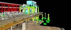
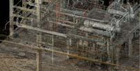
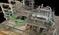
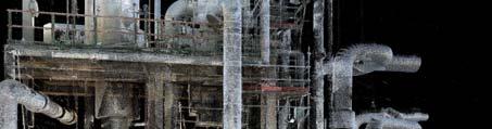
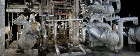
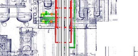
2 What are the results? PROJECT benefits for utilizing HDS technology Safety, Safety, Safety! Able to utilize 2-3 person scanning crew on (1) field trip as compared to a 4- person design crew on multiple trips; The facility is brought to the design staff, as compared to taking the design staff to the facility; Speeds up design and engineering processes; 7 8 Project benefits for utilizing HDS technology (cont d) The piping is added within the design module Engineers and Designers can now concentrate on their specific tasks at hand instead of having to travel onto locations for days gathering information. Laser scans provide us with more information than is required for a project and in some cases it allows for future work to be done as well; Mustang construction is finding that scans, when utilized within the design process, produce less than 1% error rate in construction and installation errors (pre-scanning was approx. 14-1%). D-Points are located and the new Pipe is added Note: The Scan data helps speed the design process by adding the as-built information of the existing facility 9 10 Laser Scans shown within design environment Structural As-Built with laser scan overlay 11 12


3 Tie-in piping added to field scan data ICP piping added to field scan data within model Importance of TruView Who uses TruView? TruView Key Plan Design team has 100% access to facilities scan information 15 All 30º Views / RED LINE Markups 3 Dimensional Measurements Our Clients Client Field Operations Personnel The Management Team The Engineering Team The Design Team Construction / Fabricators / Installation Personnel Wipco provides TruView files to the clients at no cost to them. 1 Example of Dimensions and Notes Example of Tie-In & Demolition Area of Interest 17 18


4 Bring Scan Image into CAD & Add Notes Example of Deliverable for Tie-In & Pipe Demolition Drawing Distribution of technical data Sometimes you have to be on site to appreciate the size of things! 22 Distribution of technical data NavisWorks Integrated with engineering systems PDMS Global models StatoilHydro currently has the world s largest implementation of PDMS Global including 41 PDMS facility models being updated from ~200 satellite locations by ~2000 daily users Locations in England, Scotland, Germany, Finland, Poland, Russia, Korea, India, Singapore in addition to Norway At the moment, we have ~140 ongoing projects (larger modifications >150 MNOK) in these models 23 24


 Handles for rotation")


5 Integrated part of the 3D visualisation tools Integrated part of the 3D visualisation tools NavisWorks viewer with 3D design data NavisWorks viewer with 3D design data and laser scan point cloud data Integrated part of the 3D visualisation tools The Troll A platform has an overall height of 472 meters, weighs 5,000 tons and has the distinction of being the tallest structure ever moved by mankind. Finally, TruView with photorealistic rotary laser scan data presentation. 27 The Advantages of Using Cyclone Useful Tools in Cyclone Fun with Handles Easy access to a Parts Tables Easier to deal with non aligned objects (Pipework) Cloud base package Region grow tools available if needed Limit box hides everything that you don t need to see Handles and Rotation Handles for stretching (orange) Handles for rotation (hotkey r) Using CTRL button to move in axis s Using ALT key to move perpendicular to viewing plane Using SHIFT key to snap to points Combining CTRL and SHIFT keys to move and move & snap an entire object


6 Useful Tools for Cyclone The Look down the Beam method Useful Tools for Cyclone The Look down the Beam method Isolate off smaller section of beam Use insert beam option Use handles to get it close to right place Looking down beam use ALT key to align the two centre points Use rotation handle to get the rotation right Stretch beam out to its extremities Insert other objects using centre handles (eg. Flanges/Elbows on pipe ends) Using this method, we have been able to model an average >250 beams per day! Useful Tools in Cyclone UCS UCS can be used to quickly align & rotate beams Generally use a long wall or centres of columns at either end of job Add line and move to even z values Use set coordinate system from points When inserting beams use the align to xy&z axis to align beam Advantage of highlighting beams that are not installed correctly or bowing Useful Tools in Cyclone Grouping and Adjusting Often jobs are symmetrical or are common along a path Using group tool, group objects together Copy & paste and use rotate toolbox to rotate 90, 180 or whatever is required Change layer/colour and check off each beam once area is correctly positioned Adds speed as each beam is correct size and approximately positioned Useful Tools for Cyclone Unify and Reduce point cloud spacing Plant Operation For beam work or piping a reduction of 0.015m will still be able to be modelled Increases viewing and modelling speed Original scan data can always be still be established by recreating another Modelspace Training Virtual site visits 3


 1 2 3D Laser Scanning")


7 D Laser Scanning Microstation Autocad Navisworks Smartplant Review PDS - PDMS 3D Model (I-View Cad) 3 4 3D Laser Scanning Documentation Geometry-Extraction (Cyclone pcf Basic) Spec Definition (Smartplant Isometrics) 1 2 3D Laser Scanning Documentation Registration Geo-reference Cyclone/CloudWorx db - Unify Design Review - NavisWorks Plantview Plant Maintenance Accurate As-built Documents Isometric Drawings MTO s Piping Spec Modifications New Piping Isogen Isometric Piping Documentation 37 3-a 3-b Geometry Extraction Geometry Extraction Basic Modeling 3-b Geometry Extraction Basic Modeling 3-c Geometry Extraction Basic pcf


 3D Modell")


8 I-Sketch Import - Specification Definition P&ID Implementation 4-a I-Sketch Import - Spec Definition 4-b I-Sketch Isometric (Isogen) MTO s P&ID 5 3D Model NavisWorks MicroStation - AutoCAD (I-View Cad Export) 3D Modell Navisworks Microstation - Autocad (I-View Cad Export) 3D Modell 3D Integration 3D Modell Integration New Piping 3D Model Integration
9 Plant Maintenance 3D Model Integration Cyclone / I-Sketch (Pcf) I-View Cad Plant Maintenance Equipment Removal / Replacement Geo-Tiff Workflow Geo-Tiff Plant Maintenance Accurate As-built Documents Layout Drawings 52 Microstation - Autocad Geo-Tiff Workflow Geo-Tiff Workflow


 57 58 3D Design: CloudWorx for Aveva PDMS This product")


10 Geo-Tiff Workflow Truview Geo-Tiff Workflow Tips Cyclone: Unified Clouds Limit Boxes with Overlap Multiple Modelspace Views Rendering in Cyclone Silhouettte Front Rendering MicroStation AutoCAD Raster with Transparency Geo-Tiff Truview Picture Exposure Optimization Stitching Optimization Navigation - Organization 55 Microstation - Autocad 5 Leica HDS system and CAD 3D modeling Partners 3D Design: CloudWorx for Intergraph SmartPlant Review Product Released May 1, 2005 Product is deployed in Intergraph s next generation review and walk-through platform. Some delays with shipping temporary licenses available in interim. CloudWorx for Intergraph SmartPlant 3D expected Summer 200 when Intergraph makes this functionality available. Bentley CloudWorx is used with Intergraph PDS (Intergraph s current 3D Detailed Engineering Design software) D Design: CloudWorx for Aveva PDMS This product is designed for Aveva s PDMS design environment. Prototype product announcement and public demonstration at SPAR May 23, 2005 PDMS marketing video distributed to HDS sales organizations May 23, 20 Projected release target date 2H (Important Qualifier: Dependent on Aveva s resource availability.) Customer BETA Test opportunities for CloudWorx for PDMS for late July/early August. (Important Qualifier: Dependent on Aveva resource availability.) Question & Answer 59 0
POINT CLOUD based REVERSE ENGINEERING. Young-Ho Chai, Ph.D
 POINT CLOUD based REVERSE ENGINEERING Young-Ho Chai, Ph.D 3D Spatial Survey Workflow Hardware Requirements Phase Based Laser Scanner: -Leica ScanStation P20 x 1EA -Usage: Short-range, ~80m Time of Flight
Leveraging Point Clouds to Produce Accurate As-Built Models. Sonia Delgadillo
 Leveraging Point Clouds to Produce Accurate As-Built Models Sonia Delgadillo Time What is CADWorx fieldpipe? Easy customization Comprehensive specs Short learning curve AutoCAD -based CADWorx Plant Design
Terrestrial 3D laser scanning Practical aspects
 Terrestrial 3D laser scanning Practical aspects ISPRS WG VI/5&SC Summer School 2007 by Gregor Bilban 3D laser scanning Benefits Lower data collection costs Reduction or elimination of re-visits More accurate
A Sweet Success in Plant Documentation for Michigan Sugar Company
 A Sweet Success in Plant Documentation for Michigan Sugar Company COMPANY LOCATION 3D Imaging Services Flint, MI TOOLS USED Leica ScanStation P40 (solutionshardware-p40.html) Leica Cyclone Software (solutionssoftware-cyclone.html)
Engineering Systems Manager
 02/04/2006 1 Engineering Systems Manager Colin K Fairweather 02/04/2006 2 Point Cloud Data With PDMS On Brownfield Projects What are the benefits and why use the technology? 02/04/2006 3 The History of
Leica High-Definition Surveying Systems. Leica HDS3000. The Industry Standard for High-Definition Surveying
 Leica High-Definition Surveying Systems Leica HDS3000 The Industry Standard for High-Definition Surveying HDS High-Definition Surveying TM : Laser Scanning Redefined High-Definition Surveying, or HDS,
The Leica HDS Family. The Right Tool for the Job HDS3000 HDS2500 HDS4500. Cyclone & CloudWorx. Press the QuickScan button to define the field-of-view.
 HDS2500 High accuracy scanner, ideal for fixed or raised installations when leveled tripod mounting is not practical, or areas with less stringent field-of-view requirements. The Leica HDS Family Time-of-flight
 www.lfm-software.com LFM Software Overview Realise the true value of your laser scan data. Outside the EPC environment, Owner Operators are now also recognising the benefits of 3D laser scanning. Laser
Laser Scanning & Creation of 3D Models For BIM and Process Facilities
 Specialised Surveying Solutions Presented to: ICES UAE Region Abu Dhabi November 2009 Land and Engineering Surveying Services 3D Laser Scanning & Modeling Laser Scanning Technology Zoller+Fröhlich Phase
Leica Cyclone 5.4 Technical Specifications
 Leica Cyclone 5.4 Technical Specifications HDS Scanner control and operation Scan Scan Scan Register Model Survey Viewer Acquire and display image Acquire image at specified resolution (high, medium, low)
CloudWorx for Intergraph SmartPlant Review 1.0 Tutorial High-Definition Surveying. Tutorial-Plant
 Tutorial-Plant CloudWorx 1.0 for Intergraph SmartPlant Review CloudWorx for Intergraph SmartPlant Review provides a dynamic and flexible way to work efficiently with large as-built point clouds within
ARECATECH SDN BHD CAPTURE THE REALITY IN TOUCH WITH TOMORROW
 CAPTURE THE REALITY IN TOUCH WITH TOMORROW ARECATECH SDN BHD 3D Laser Scanning Integrity and Management Services Detail Engineering Design Support & COMOS Intelligent P & ID Services SmartPlant - PDMS
Marc De Bruyne 3D Design Improvement Leader, DOW Chemical
 Marc De Bruyne 3D Design Improvement Leader, DOW Chemical John Foster Director, Profox Companies DOW Chemical Terneuzen in the Netherlands Globally, second largest DOW site after Freeport US. Producing
OPEN. INTELLIGENT. Laser Scanning Software Solutions
 OPEN. INTELLIGENT. Laser Scanning Software Solutions www.lfm-software.com The Future of Laser Scanning Safe and efficient operation of complex engineering assets, and the efficient management of their
Cyclone Tips and Tricks. Hexagon Geosystems Track June 2012
 Cyclone Tips and Tricks Hexagon Geosystems Track June 2012 Built-in Hotkeys Enhanced Working Format Open GL Modes There are some very powerful built-in viewing hotkeys in Cyclone. Here are some of them:
Laser Scanning. 3D Model is not existing and is required for: studies revamping maintenance HSE integration in another 3D model archiving
 Laser Scanning Laser Scanning Laser scanning is used whenever: 3D Model is not existing and is required for: studies revamping maintenance HSE integration in another 3D model archiving 2 Object acquisition
Leica Cyclone 9.1 and Leica CloudWorx Technical Specifications
 Leica 9.1 and Leica CloudWorx Technical Specifications Leica 9.1 Technical Specifications REGISTRATION, VISUALIZATION, MODELING & QUERY TOOLS 3D navigation Panoramic view mode Cloud Level of Detail for
Leica Cyclone 9.1 and Leica CloudWorx Technical Specifications
 Leica 9.1 and Leica CloudWorx Technical Specifications Leica 9.1 Technical Specifications REGISTRATION, VISUALISATION, MODELLING & QUERY TOOLS 3D navigation, including 3D mouse support Panoramic view mode
Leica Cyclone 8.1 Leica CloudWorx Technical Specifications
 Leica 8.1 Leica CloudWorx Technical Specifications Leica 8.1 Technical Specifications HDS SCANNER CONTROL AND OPERATION & REGISTRATION Acquire and display image ^ ^ ^ Acquire image at specified resolution
Simplicity is the new black: The BLK360 story
 Simplicity is the new black: The BLK360 story Vanda KADLECIKOVA Leica Geosystems Heerbrugg, Switzerland E-mail: vanda.kadlecikova@leica-geosystems.com Abstract Meet the game changer. The new Leica BLK360
Extracting Plant Deliverables from AutoCAD Point Clouds
 Extracting Plant Deliverables from AutoCAD Point Clouds The webinar will begin shortly. You will hear silence until the webinar begins. Please note that this webinar is being recorded and all registrants
Leica Geosystems HDS. Welcome to CloudWorx 3.2 Tutorial. Cyclone CloudWorx 3.2 Tutorial Section I High-Definition Surveying
 8:08 Cyclone CloudWorx 3.2 Tutorial Section I Welcome to CloudWorx 3.2 Tutorial CloudWorx is the high-performance point cloud solution that enables you to load, render, analyze and extract information
Module 7 Defining Coordinate Systems
 Module 7 Defining Coordinate Systems Introduction Objectives Outline of Topics Covered The use of coordinate systems is very important in managing 3D spatial data including point clouds. In this module
REGISTRATION, VISUALISATION, MODELLING & QUERY TOOLS
 REGISTRATION, VISUALISATION, MODELLING & QUERY TOOLS BASIC 3D navigation, Pan, Zoom, Rotate 3D mouse support Panoramic view mode Align to surface view mode Cloud Level of Detail for fast visualisation
Autodesk Plant Design Suite. Build on the power and familiarity of AutoCAD with multidiscipline plant design solutions.
 Autodesk Plant Design Suite Build on the power and familiarity of AutoCAD with multidiscipline plant design solutions. The Suite Advantage: Convenient, Comprehensive, Cost-Effective Autodesk Plant Design
3D Industrial plants. Documentation
 3D Industrial plants Documentation Published by: FARO Europe GmbH & Co. KG, Lingwiesenstrasse 11/2, D-70825 Korntal-Münchingen, Tel: +49 7150 9797-0, Fax: +49 7150 9797-44, info@faroeurope.com, www.faro.com
Autodesk Plant Design Suite. Integrated solutions for plant design and whole-project review
 Autodesk Plant Design Suite Integrated solutions for plant design and whole-project review The Suite Advantage The suite combines AutoCAD, AutoCAD P&ID, AutoCAD Plant 3D, and Autodesk Navisworks software
MicroStation V8i Tips and Tricks and more
 The following Tips and Tricks include features that are new in the version SELECTSeries 2&3 and some that have been around for a while enjoy Explorer the File Open dialog. Let s take a close look at the
Leica Cyclone and Leica CloudWorx Technical Specifications
 Leica Cyclone and Leica CloudWorx Technical Specifications Valid as of December 2017 leica-geosystems.com REGISTRATION, VISUALISATION, MODELLING & QUERY TOOLS 3D navigation, Pan, Zoom, Rotate / 3D mouse
Leica 3D Disto PROJECTOR function for stair case applications
 Leica 3D Disto PROJECTOR function for stair case applications Workflow description: Measurement Stair Design Set Out of fixing points Preparing the measurement 1 mark 1 point on each wall of the stair
Leica Cyclone Basic User Manual November 2015
 Leica Cyclone Basic User Manual November 2015 C.R.Kennedy & Company Page 1 Contents Copying Raw Files from the C10/P20 Scanner to the PC... 6 Copy Raw files from the USB stick to the PC... 6 Opening Cyclone...
With FARO PointSense for Revit. Jörg Braunes Platform Owner Software Chris Palmer Sales Engineer 1
 From Point Clouds to BIM Models With FARO PointSense for Revit Jörg Braunes Platform Owner Software Chris Palmer Sales Engineer 1 Agenda Scan to BIM with Revit PointClouds in Revit Advanced Workflow with
ON THE ROAD JULY/AUGUST MAP PROJECTIONS The importance of horizontal and vertical datums in GIS mapping
 VOLUME 4 ISSUE 5 JULY/AUGUST 2014 ON THE ROAD 30 40 62 MAP PROJECTIONS The importance of horizontal and vertical datums in GIS mapping FOLLOW THE LEDDAR A special purpose sensor that does several 3D measurement
DEMO OF SMART STRESS ISO (SSI)
") DEMO OF SMART STRESS ISO (SSI) The information flow in the complete Life Cycle Solution is the following: PDS PDMS AutoPlant Piping Specs I-EXPORT IDF/PCF I-CONVERT I-SKETCH (ISOGEN) PIPENET Standard PIPENET
DEMO OF SMART STRESS ISO (SSI) The information flow in the complete Life Cycle Solution is the following: PDS PDMS AutoPlant Piping Specs I-EXPORT IDF/PCF I-CONVERT I-SKETCH (ISOGEN) PIPENET Standard PIPENET
Suite en It Up with Autodesk ReCap
 Chad Studer ADSK Solutions RC3165 Static and mobile laser scanning technologies capture millions of points and provide photorealistic interactive virtual sites known as point clouds. With Autodesk ReCap
Leica 3D Disto PROJECTOR in stair case
 Leica 3D Disto PROJECTOR in stair case Workflow description: Measurement Stair Design Projection of fixing points Preparing the measurement 1 mark 1 point on each wall of the stair case Measurement of
Converting Existing Piping Specs
 Converting Existing Piping Specs Ian Matthew Autodesk, Inc. PD4216: In this class, we will show you how to convert piping specs from other 3D products. This class will demonstrate how to efficiently use
Product Release Summary AVEVA LFM Server
 Product Release Summary AVEVA LFM Server 5.0.0.5 Release Date: 18/03/2019 This document outlines all changes made in the above release of AVEVA LFM Server. Document Prepared by: Praveen Vankdoth Application
Microsoft HoloLens Joe Hines
 Microsoft HoloLens Joe Hines In recent years, the push to utilize technology has been advancing from one job to the next in the construction industry. The main benefits of technology have been increased
Leica ScanStation C10 The All-in-One Laser Scanner for Any Application
 The All-in-One Laser Scanner for Any Application Versatility, Productivity, Value Many organizations interested in laser scanning to diversify and/or improve current business have been waiting for a scanner
Displayed with permission The American Surveyor April/May Copyright 2009 Cheves Media
 NASA s Environmental Simulation Chamber A at the Johnson Space Center in Houston will require upgrades to accommodate testing of components for the new space telescopes. Laser scanning with the FARO LS
POINT CLOUD PROCESSING
 POINT CLOUD PROCESSING August 19-20 Northern California Bentley Bash 2011 UC Berkeley Berkeley, CA Taught by: Mike Lazear Point Cloud Processing Point Cloud Processing N O R T H E R N C A L I F O R N I
Leica Cyclone and Leica CloudWorx Technical Specifications
 Leica Cyclone and Leica CloudWorx Technical Specifications Valid as of August 2018 leica-geosystems.com Key 1 These types can be created using best-fit methods 2 As delivered in database, cannot modify
Overview of the Trimble TX5 Laser Scanner
 Overview of the Trimble TX5 Laser Scanner Trimble TX5 Revolutionary and versatile scanning solution Compact / Lightweight Efficient Economical Ease of Use Small and Compact Smallest and most compact 3D
Scan-to-BIM. NEWBIM ApS, Galina Slavova CEO, BIM Specialist
 Scan-to-BIM NEWBIM ApS, Galina Slavova CEO, BIM Specialist Agenda What is Building Information Modeling (BIM) About NEWBIM ApS 3D Laser Scanning Integration Case Study Demonstration Building Information
Terrestrial LiDAR. Patrick Crawford. Harnessing the Power of Big Data for Asset and Facility Management WHITE PAPER SHAFER, KLINE & WARREN
 WHITE PAPER Terrestrial LiDAR Harnessing the Power of Big Data for Asset and Facility Management Patrick Crawford Team Leader, Geospatial Systems SHAFER, KLINE & WARREN Executive Summary Terrestrial LiDAR
General Software. Program (Software House) Function. Office Productivity. Office (Microsoft) PDF File Generation and Management
 Function. Office Productivity. Office (Microsoft) PDF File Generation and Management") Company Software General Software Office (Microsoft) Office Productivity Acrobat Professional (Adobe) Primavera P6 Professional R8.2 (Oracle) Microstation Ver.J, V8,XS and all versions (Bentley) Autocad
Company Software General Software Office (Microsoft) Office Productivity Acrobat Professional (Adobe) Primavera P6 Professional R8.2 (Oracle) Microstation Ver.J, V8,XS and all versions (Bentley) Autocad
CAXperts - Engineered Efficiency. Michel J. Lespérance, Sales Manager Americas Stefan Bauer Product Manager
 CAXperts - Engineered Efficiency Michel J. Lespérance, Sales Manager Americas Stefan Bauer Product Manager Thank you for inviting us! About CAXperts. Buenas tardes! Gracias mucho Adrian invitar a CAXperts
Table of Contents. Note to Self-Paced Users of the Day 2 Seminar Handbook. Notices 1. Quick Reference 2. Seminar Outline 14
 Table of Contents Note to Self-Paced Users of the Day 2 Seminar Handbook i Notices 1 Quick Reference 2 Seminar Outline 14 Program and Vector Data Overview 17 A Toolbox for Creating Earthwork Models 17
SOLIDWORKS 2017 Keyboard Modifiers & Shortcuts
 SOLIDWORKS 2017 Keyboard Modifiers & Shortcuts Copy/Paste Ctrl+C and Ctrl+V These are similar in functionality to Windows. Sketches Copies and pastes sketch entities. Part Copies and pastes sketches. Assemblies
2011 Bentley Systems, Incorporated. Bentley Descartes V8i Advancing Information Modeling For Intelligent Infrastructure
 Bentley Descartes V8i Advancing Information Modeling For Intelligent Infrastructure Agenda Why would you need Bentley Descartes? What is Bentley Descartes? Advanced Point Cloud Workflows Advanced Terrain
Product Release Summary AVEVA LFM Server
 Product Release Summary AVEVA LFM Server 4.4.2.19 Release Date: 02/08/2018 This document outlines all changes made in the above release of AVEVA LFM Server. Document Prepared by: Praveen Vankdoth Application
TAKING LIDAR SUBSEA. Adam Lowry, Nov 2016
 TAKING LIDAR SUBSEA Adam Lowry, Nov 2016 3D AT DEPTH Based in the technology hub of Boulder, Colorado, 3D at Depth is dedicated to the development of underwater laser measurement sensors and software Patented
3D IN GIS. 1. Presentation of the results of the scientific and technical contents
 G. Nagy, A. Szepes 3D in GIS 3D IN GIS NAGY Gábor, assistant professor, University of West Hungary, Faculty of Geoinformatics, Department of GIS, ng@geo.info.hu SZEPES András, associate professor, University
Autodesk Fusion 360: Introduction. Overview
 Overview Fusion 360 is a cloud-based CAD/CAM tool for collaborative product development. The tools in Fusion enable exploration and iteration on product ideas and collaboration within a product development
Using Laser Scanning technology and software. Chris Palmer Sales Engineer 28 th April
 Construction Verification Using Laser Scanning technology and software Chris Palmer Sales Engineer 28 th April 2017 1 Contents What is construction verification? How do we measure and check construction
Realworks Software. A Powerful 3D Laser Scanning Office Software Suite
 TECHNICAL NOTES Realworks Software A Powerful 3D Laser Scanning Office Software Suite Trimble RealWorks is a powerful office software that imports rich data from your 3D laser scanning instrument and transforms
RealWorks Software. A Powerful 3D Laser Scanning Office Software Suite
 TECHNICAL NOTES RealWorks Software A Powerful 3D Laser Scanning Office Software Suite Trimble RealWorks is a powerful office software that imports rich data from your 3D laser scanning instrument and transforms
Leveraging 2D Data in 3D Modeling
 Leveraging D Data in 3D Modeling Leveraging D Data in 3D Modeling As more and more companies switch to 3D modeling the question of utilizing existing D data and referenced D data from collaborative sources
SmartPlant Fusion: Technology and Capabilities
 W H I T E P A P E R SmartPlant Fusion: Technology and Capabilities The Fastest and Smartest Way to Make Documents and Drawings Available for Decision Support Contents 1. Introduction... 1 2. SmartPlant
Leica ScanStation C5 Scalable Laser Scanner
 Leica ScanStation C5 Scalable Laser Scanner Leica ScanStation C5 Scalable from the Start Companies entering into laser scanning are often faced with inflexible and complex situations and would like a scalable
technical notes trimble realworks software
 technical notes trimble realworks software A POWERFUL 3D LASER SCANNING OFFICE SOFTWARE SUITE Designed for today s multifaceted scanning professional, Trimble RealWorks is a powerful office software that
2011 Bentley Systems, Incorporated. Bentley Descartes V8i (SELECTseries 3) Advancing Information Modeling For Intelligent Infrastructure
 Advancing Information Modeling For Intelligent Infrastructure") Bentley Descartes V8i (SELECTseries 3) Advancing Information Modeling For Intelligent Infrastructure What is Bentley Descartes? Image Processing Raster Geo-Referencing Advanced raster transformation (warping,
Bentley Descartes V8i (SELECTseries 3) Advancing Information Modeling For Intelligent Infrastructure What is Bentley Descartes? Image Processing Raster Geo-Referencing Advanced raster transformation (warping,
Getting Started with Onshape
 Getting Started with Onshape First Edition Elise Moss, Authorized Onshape Partner SDC PUBLICATIONS Better Textbooks. Lower Prices. www.sdcpublications.com Powered by TCPDF (www.tcpdf.org) Visit the following
Trimble RealWorks. What s new in version 9.0
 Trimble RealWorks What s new in version 9.0 Trimble RealWorks v9.0 What s new Over 40 new features and enhancements Navigation and visualization improvements SketchUp interoperability Additional 3 rd party
QuickStart Guide: Leica Cyclone REGISTER 360
 Leica Geosystems QuickStart Guide: Cyclone REGISTER 360 Product Leica Cyclone REGISTER 360 1.4 Date 17 October 2017 From HDS Software Product Management Contents Introduction... 2 Installation... 3 Licensing
Bentley Descartes and what s new in Descartes V8i (SELECTseries 3) What is Bentley Descartes? 2011 Bentley Systems, Incorporated
 What is Bentley Descartes? 2011 Bentley Systems, Incorporated") Bentley Descartes and what s new in Descartes V8i (SELECTseries 3) Tom Stogdill Bentley Systems, Inc. What is Bentley Descartes? Image Processing Raster Geo-Referencing Advanced raster transformation (warping,
Bentley Descartes and what s new in Descartes V8i (SELECTseries 3) Tom Stogdill Bentley Systems, Inc. What is Bentley Descartes? Image Processing Raster Geo-Referencing Advanced raster transformation (warping,
Table Of Contents. Introduction Installation Included Materials System Requirements Quick Start... 9
 Cyclone 5.8 Table Of Contents Introduction... 3 Cyclone Software Introduction... 3 Installation... 5 Included Materials... 5 System Requirements... 5 Installing Cyclone... 6 Obtaining your Cyclone License...
Developing a Method Using Field Surveying Techniques and Instruments to Create 3D Terrain Models. Faheem Muhammad
 Developing a Method Using Field Surveying Techniques and Instruments to Create 3D Terrain Models Faheem Muhammad Office of Science, Science Undergraduate Laboratory Internship (SULI) Savannah State University
6SigmaRoom R8 What s New
 SigmaRoom R8 What s New Contents 6SigmaDC R8 Overview... 2 R8 Highlights... 3 Discoverable Interface... 4 Welcome Screen... 4 New Controls... 5 Extended Tooltips... 5 On-Screen Hints... 6 Confirmation
3D Manufacturing Facility and Production Line Capture
 SPAR 2004 Symposium May 19, 2004 3D Manufacturing Facility and Production Line Capture Presented by: Bill Campbell GM Vehicle Operations Competitive Operations Engineering Mike Ryan GHAFARI Companies SPAR
User Manual PointCab 2
 User Manual PointCab 2 Table of Contents Welcome! 4 What's new? 5 Automatic tile size 5 Elevation map creator 5 LSE Converter 5 Relative paths in DXF files 5 SketchUp plug-in with planar support 5 Scale
3D Terrestrial Laser Scanner Innovative Applications for 3D Documentation
 3D Terrestrial Laser Scanner Innovative Applications for 3D Documentation Rodney Chaffee Head of Sales, FARO Asia Pacific 3D Laser Scaning Market 2017 2.3 Billion $ 2012 1.3 Billion $ CAGR : > 12% Source:
INTEROPERABILITY SUMMARY Leveraging 3D Designs & Data
 W H I T E P A P E R INTEROPERABILITY SUMMARY Leveraging 3D Designs & Data Referencing and Converting Existing External Data to and from Multiple Formats in Engineering and Construction Projects Contents
COMPUTER AIDED ARCHITECTURAL GRAPHICS FFD 201/Fall 2013 HAND OUT 1 : INTRODUCTION TO 3D
 COMPUTER AIDED ARCHITECTURAL GRAPHICS FFD 201/Fall 2013 INSTRUCTORS E-MAIL ADDRESS OFFICE HOURS Özgür Genca ozgurgenca@gmail.com part time Tuba Doğu tubadogu@gmail.com part time Şebnem Yanç Demirkan sebnem.demirkan@gmail.com
Leica DISTO X3 Designed for tough, rugged conditions
 Leica DISTO X3 Designed for tough, rugged conditions The rugged Leica DISTO X-series combines innovative measuring technologies with a site-proof design and simple user interface. Together with the Leica
NEW APPROACH FOR SAFE, FAST AND ACCURATE SURVEY OF DEEP MINE SHAFTS
 NEW APPROACH FOR SAFE, FAST AND ACCURATE SURVEY OF DEEP MINE SHAFTS by Norbert Benecke & Peter Cain DMT GmbH &Co. KG, Germany / DMT Geosciences, Canada Kinemattic Shaft Survey 2013 Page 1 Who is DMT? is
Geosystems Monday Hands-on Sessions
 Geosystems Monday Hands-on Sessions 1110: HDS University - Leica ScanStation P30/40 (and C10 & P20) Operation and Surveying Workflows (CEU eligible nominal fees will apply) The all new Leica ScanStation
Increase Field Survey Efficiency by Merging Technologies in NOVA MultiStation. Vincent Lui Leica Geosystems Ltd
 Increase Field Survey Efficiency by Merging Technologies in NOVA MultiStation Vincent Lui Leica Geosystems Ltd Advantages of Laser Scanning Advantages of TPS Measurements Advantages of Imaging Advantages
Trimble Realworks Software
 TECHNICAL NOTES Trimble Realworks Software A Powerful 3D Laser Scanning Office Software Suite DESIGNED FOR TODAY S MULTIFACETED SCANNING PROFESSIONAL, TRIMBLE REALWORKS IS A POWERFUL OFFICE SOFTWARE THAT
1.1: Introduction to Fusion 360
 .: Introduction to Fusion 360 Fusion 360 is a cloud- based CAD/CAM tool for collaborative product development. The tools in Fusion enable exploration and iteration on product ideas and collaboration within
Why CAXpert? Use Cases to Consider
 Why CAXpert? Use Cases to Consider We ve highlighted some areas that offer significant benefits, along with customers who show that use case in action. See if any of these solve a problem for you. 2016-07-04
A Quick Spin on Autodesk Architectural Studio
 December 2-5, 2003 MGM Grand Hotel Las Vegas A Quick Spin on Autodesk Architectural Studio Mario Guttman, AIA Kevin Durham Christie Landry (Instructor) (Assistant) (Assistant) BD13-5L Autodesk Architectural
KRISTAPS KLAVA - HEAD OF LASER SCANNING DEPARTMENT AT MERKO 3D LASER SCANNING POSSIBILITIES IN REAL ESTATE
 KRISTAPS KLAVA - HEAD OF LASER SCANNING DEPARTMENT AT MERKO 3D LASER SCANNING POSSIBILITIES IN REAL ESTATE Overview 1. What is laser scanning; 2. Technology; 3. End results of laser scanning; 4. Applications;
Autodesk Navisworks Freedom Quick Reference Guide
 WP CAD 00074 March 2012 Guide by Andy Davis Autodesk Navisworks Freedom Quick Reference Guide Quick Reference Guide to Autodesk Navisworks Freedom Opening a Model To open a model, click on the Application
Course BIM MEP Diploma Revit MEP Navis Works
 Course BIM MEP Diploma Revit MEP Navis Works BIM Electromechanical Diploma : BIM MEP diploma maximize the BIM workflow optimization and gives the engineer the full capabilities to perform MEP Model consists
INVESTIGATION ON LASER SCANNERS *
 IWAA2004, CERN, Geneva, 4-7 October 2004 INVESTIGATION ON LASER SCANNERS * Brian Fuss, Catherine Le Cocq, Robert Ruland Stanford Linear Accelerator Center, Stanford, CA, USA Rudolf Staiger Essen University,
FILTER PACKAGE USER S GUIDE
 FILTER PACKAGE USER S GUIDE 1 CONTENT I. Introduction... 3 II. Installation... 3 III. Using the filters... 4 a- General... 4 b- Edge filter... 5 c- Uniform filter... 7 d- Angular filter... 8 e- Circle
Point Cloud Processing and Large Scalable Terrain Model Extraction Inga Morozoff
 Point Cloud Processing and Large Scalable Terrain Model Extraction Inga Morozoff 1 Point cloud data is a new data type that s being driven by the need for accurate 3D as-built information. Point cloud
COMOS. Lifecycle COMOS Walkinside Getting Started. Security information 1. Which functionalities are not covered in this manual? 2
 Security information 1 Which functionalities are not covered in this manual? 2 COMOS Lifecycle Getting Started Open Walkinside Model 3 Navigating 4 Checking projects 5 System integration 6 05/2016 V 10.2
FAQs Contents 1. General Product Information Support and Training Platform and System Requirements... 6
 FAQs Contents 1. General Product Information... 4 1.1 What is System Pvex TM?... 4 1.2 Who designed and developed System Pvex TM?... 4 1.3 What are the main features of System Pvex TM?... 4 1.4 Is it possible
A Basic Guide to Modeling Landscapes in Google SketchUp
 DYNASCAPE SOFTWARE INC. A Basic Guide to Modeling Landscapes in Google SketchUp A DS Sketch 3D User Guide Volume 2 This guide will take you through the steps of creating a 3D model of a landscape in Google
OG10333-L Behind the Face Tips and Tricks in AutoCAD Plant 3D
 OG10333-L Behind the Face Tips and Tricks in AutoCAD Plant 3D Bernd Gerstenberger Autodesk Learning Objectives Discover several, maybe surprising examples of how you can configure your project and your
Autodesk NavisWorks Course :-
 Autodesk NavisWorks Course :- Course Description The Autodesk Navisworks training course instructs students in best approaches to combine 3D geometry from cross disciplines into one scene to enable effective
Tutorial Second Level
 AutoCAD 2018 Tutorial Second Level 3D Modeling Randy H. Shih SDC PUBLICATIONS Better Textbooks. Lower Prices. www.sdcpublications.com Powered by TCPDF (www.tcpdf.org) Visit the following websites to learn
Leica DISTO X4 Designed for bright, outdoor environments
 Leica DISTO X4 Designed for bright, outdoor environments Pointfinder camera The DISTO X4 is equipped with a Pointfinder camera allowing you to easily target distant objects in bright sunlight. Even if
Revit Structure. Autodesk Navisworks
 What is BIM? Autodesk BIM is an intelligent model-based process that helps owners and service providers achieve business results by enabling more accurate, accessible, and actionable insight throughout
BIM & Digital Transformation Scotland Live 2018 Capturing 3D Reality at the push of a button
 BIM & Digital Transformation Scotland Live 2018 Capturing 3D Reality at the push of a button Gary Kelly Country Manager Scotland Leica Geosystems @LeicaScot Capturing 3D Reality at the push of a button
Geospatial Engineering Problems & Solutions Associated With NDP Roads, Tunnelling & Civil Engineering Projects Use of HDS Leica Laser Scanners
 Geospatial Engineering Problems & Solutions Associated With NDP Roads, Tunnelling & Civil Engineering Projects Use of HDS Leica Laser Scanners Laser Scanning Laser Scanning is a method of collecting large
OBJECT MANAGER PACKAGE USER S GUIDE
 OBJECT MANAGER PACKAGE USER S GUIDE 1 CONTENT I. Introduction... 3 II. Installation... 3 III. Using the plugins... 4 a- General... 4 b- Object properties manager... 4 c- Pipe manager... 6 d- Plane manager...