Case Study. How we build reality. Company Overview. Estimating mass properties of dinosaurs using laser imaging and 3D computer modeling
|
|
|
- Suzanna Manning
- 6 years ago
- Views:
Transcription


1 How we build reality Case Study Estimating mass properties of dinosaurs using laser imaging and 3D computer modeling Company Overview Z+F is the world leader in the manufacturer of phase based laser scanners. Our strengths lie in our powerful 3D laser scanning hardware and software innovations which are considered to be the best on the market, the continual nature of these innovations and the support that we show to our customers who are loyal and longstanding owing to the service we provide. In cooperation with the University of Manchester Palaeontology Research Group


 where 3D digital outcrop")


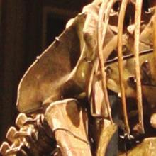
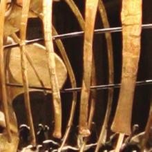
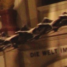
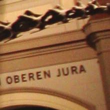
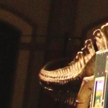
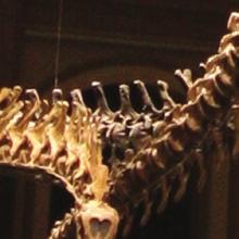
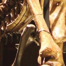
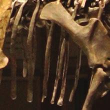
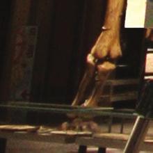
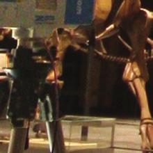
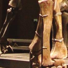
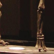
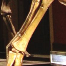
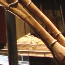
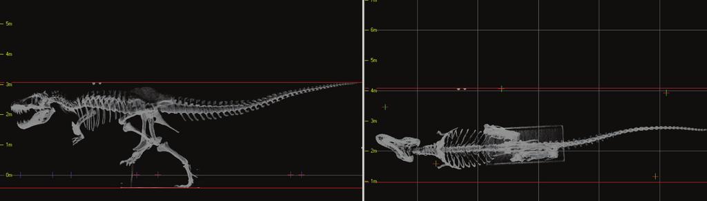
2 Introduction 3D laser scan of the Tyrannosaurus rex known as Stan. Estimating the body mass of vertebrates is an important factor to quantify if we are to understand the locomotion and behavior of both, extant and extinct species. Mass estimates can be more carefully estimated when complete to near-complete mounted skeletons are laser scanned. The data can be used to reconstruct digital models. The 3D digital model can then be imported to suitable processing software that allow mass estimations to be calculated. The virtual body volume can also be manipulated to account for subtile changes in body mass that might affect locomotor ability and centre of mass. The benefits of rapid 3D capture are now also being realised in the broader fields of geological heritage conservation (geoconservation) where 3D digital outcrop models provide valuable data on the year on year weathering of type localities or important excavation sites. For this case study, the work on body mass estimates for dinosaurs, undertaken by Paleontology Research Group based at the University of Manchester, 3D laser scanning technologies was used to modify model properties non - destructively. The 3D laser scanning technology of Z+F was used to scan five specimens of dinosaurs at museums in the UK, USA, China and Argentina over a 12 months period. The whole process was filmed by National Geographic who saw this innovative application of the new techniques as an important example of how 21st Century technology is assisting palaeontology. 2 3

3 Methodology The Z+F IMAGER 5006i was the perfect choice for use of 3D scanning by teams of palaeontologists in the field to scan dinosaur excavations and dinosaur tracksites. Instruments and Software The Z+F IMAGER 5006i phased based scanner was used due to its accuracy, resolution and data acquisition rate of 500,000 points per second. Vast amounts of data were quickly generated and stored on the IMAGER 5006i internal hard drive ( sometimes directly to an attached netbook which was both, very cost effective and allowed a secondary back-up to the internal hard-drive of the scanner ). The huge advantage of the Z+F IMAGER scanners is that they are totally encapsulated units where no peripherals are required to operate. This was a great advantage for setup positions the skeletons where any cabeling would beneath an obstacle. It was important that the scanner was portable and light due to the diversity of environments in which it was used by the Manchester team, from desert to museums and from mountain slopes to floorplains. Many scans were produced and registered via the cloud-to-cloud technique. Preview scans in real-time enabled onsite verification of the recorded data. 3D models were then generated to produce a high resolution skeletal framework for use in locomotion software written by members of the team at the University of Manchester. Why was laserscanning chosen To enable the researchers to estimate how Dinosaurs moved and functioned, it is important to be able to capture precise data on the geometry and morphology of mounted skeletons. The Z+F scanner provided the fastest and accurate data capture technique available to the team. The data captured provides detailed information on the measurements, dimensions and colour ( if desired ) of real-world objects or environments. This provides a powerful source of data for the software to help determine the different key features of the dinosaur that impacted on properties such as body mass, skeleton loading, accurate body mass segments, moments of inertia for each element of the animal, etc. Access to many of the visited sites around the world was time limited, therefore it was extremely important that this time was used productively and as much data as possible was captured. Various scanning solutions were considered however the phased based scanner of Z+F was chosen because of its high resolution, scan rate, portability and overall ease of operation in extreme environments. By utilising this powerful Z+F technology, the researchers were able to spend less time on site. The quality of the data produced has enabled paleontologists to make more accurate estimates of the key locomotor parameters that help constrain their virtual dinosaurs models. 4 5


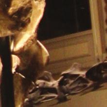


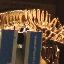


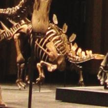

4 Deliverables Z+F IMAGER 5006i used to scan specimens of dinosaur Final deliverables The Z+F IMAGER provided scans in ASCII format for use in the University of Manchester s CAD system. LFM Register, a powerful piece of laser scanning software, developed by Z+F UK, allowed the scans to be registered together to create a 3D model for use in CAD. The fi nal deliverable enabled the palaeontologists, in cooperation with the computational biologists, to generate a virtual model of each dinosaur. Virtual muscle groups were fi tted to the virtual model to fi nd out about the muscle activation patterns. This was achieved by using an evolutionary search algorithm operating within a dynamic engine physics simulator. The resultant models generated stable locomotor gaits for all the species of dinosaurs studied. This enables researches to create a moving 3D version simulating how the dinosaur might have once moved. The project generated signifi cant interest in the research on the maximum running speeds of dinosaurs and how they once moved. The process and results of this work is included in a new six part series called Jurassic CSI commissioned by the National Geographic Channel, hosted by the Manchester palaeontologist Dr Phil Manning. The series explores the application of 21st Century science to palaeontology and includes the work of leading scientists from around the world. Published by the National Geographic Channel, 6 7

5 Zoller + Fröhlich GmbH Simoniusstrasse Wangen im Allgäu Germany Phone: Fax: info@zf-laser.com 01/2013
How we build reality. Company Overview. Case Study Stonehenge in High Defi nition
 How we build reality Case Study Stonehenge in High Defi nition Company Overview Z+F is one of world leading manufacturers of phase based laser scanners. Our strengths lie in our powerful 3D laser scanning
How we build reality. Company Overview. Effi cient Geometric Documentation of Buildings: Castle Schloss Johannisburg in
 How we build reality Effi cient Geometric Documentation of Buildings: Castle Schloss Johannisburg in Case Study Aschaffenburg Company Overview Z+F is one of the world s leading manufacturers in the fi
Case Study. How we build reality. Company Overview. Effi cient Geometric Documentation of Buildings: Castle Schloss Johannisburg, Aschaffenburg
 How we build reality Case Study Effi cient Geometric Documentation of Buildings: Castle Schloss Johannisburg, Aschaffenburg Company Overview Z+F is one of the world s leading manufacturers in the fi eld
Case Study. How we build reality. Company Overview. High-end 3D processes at the Bavarian State Criminal Police Offi ce (BLKA)
") How we build reality Case Study High-end 3D processes at the Bavarian State Criminal Police Offi ce (BLKA) Company Overview Z+F is one of the world s leading manufacturers in the fi eld of non-contact
How we build reality Case Study High-end 3D processes at the Bavarian State Criminal Police Offi ce (BLKA) Company Overview Z+F is one of the world s leading manufacturers in the fi eld of non-contact
IMAGER The new way of scanning highly accurate, fast, reliable and flexible.
 IMAGER 5006 The new way of scanning highly accurate, fast, reliable and flexible www.zf-laser.com Advantages of the product IMAGER 5006 Wireless operation via PDA (Bluetooth) With the IMAGER 5006 Zoller+Froehlich
Z+F IMAGER 5006i. The new way of scanning highly accurate, fast, reliable and flexible
 Z+F IMAGER 5006i The new way of scanning highly accurate, fast, reliable and flexible Z+F IMAGER 5006i An improved system based upon the highly regarded Z+F IMAGER 5006 Stand alone concept Improved point
How we build reality IMAGER 5006EX
 How we build reality IMAGER 5006EX Zoller + Fröhlich Zoller + Fröhlich GmbH was founded in Wangen in 1963. Initially the company concentrated on the design and implementation of individual control systems
How we build reality. Company Overview. Train Mounted Laser Survey of Birmingham New Street Area
 How we build reality Train Mounted Laser Survey of Birmingham New Street Area Case Study Resignalling Phase 7 Company Overview Z+F is one of the world s leading manufacturers in the fi eld of non-contact
 www.lfm-software.com LFM Software Overview Realise the true value of your laser scan data. Outside the EPC environment, Owner Operators are now also recognising the benefits of 3D laser scanning. Laser
Marc De Bruyne 3D Design Improvement Leader, DOW Chemical
 Marc De Bruyne 3D Design Improvement Leader, DOW Chemical John Foster Director, Profox Companies DOW Chemical Terneuzen in the Netherlands Globally, second largest DOW site after Freeport US. Producing
Digital Preservation of the Aurelius Church and the Hirsau Museum Complex by Means of HDS and Photogrammetric Texture Mapping
 Master Thesis Ruxandra MOROSAN Ruxandra MOROSAN Digital Preservation of the Aurelius Church and the Hirsau Museum Complex by Means of HDS and Photogrammetric Texture Mapping Duration of the Thesis: 6 months
3D TECHNOLOGIES AS GLOBAL TREND
 3D TECHNOLOGIES AS GLOBAL TREND CADDprint d.o.o. who we are The company (www.caddprint.hr) was established in 2006. in Varaždin and from our first steps we are constantly initiating newest technologies
Revealing the. Stonehenge. In a major project for English Heritage, Through 3D Digital Modelling. By Neil McLeod
 Revealing the Secrets of Stonehenge Through 3D Digital Modelling In a major project for English Heritage, survey specialists Greenhatch Group used laser scanning, digital photogrammetry and Geomagic Studio
PROFESSIONAL 3D SCANNING SOLUTIONS
 ARTEC 3D SCANNERS A R T E C E V A A R T E C S P I D E R PROFESSIONAL 3D SCANNING SOLUTIONS Reverse Engineering / Quality Control / Orthopedics & Prosthetics / CGI / Media & Design / Heritage Preservation
COMET 5 3D DIGITIZING
 COMET 5 3D DIGITIZING 2 COMET 5: THE 3D SENSOR REFERENCE 3D digitizing in revolutionary shape: With the COMET5 sensor, Steinbichler Optotechnik is presenting a system perfectly fitting the steadily growing
Suite en It Up with Autodesk ReCap
 Chad Studer ADSK Solutions RC3165 Static and mobile laser scanning technologies capture millions of points and provide photorealistic interactive virtual sites known as point clouds. With Autodesk ReCap
HP-L-8.9 LASER SCANNER
 PRODUCT BROCHURE HP-L-8.9 LASER SCANNER Cost-effective laser scanning for the ROMER Absolute Arm 2 HP-L-8.9 LASER SCANNER HIGHLIGHTS MAKING LASER SCANNING ACCESSIBLE TO ALL The HP-L-8.9 is an affordable
AUTOMATIC DETERMINATION OF FOREST INVENTORY PARAMETERS USING TERRESTRIAL LASER SCANNING
 AUTOMATIC DETERMINATION OF FOREST INVENTORY PARAMETERS USING TERRESTRIAL LASER SCANNING Merlijn Simonse 1, Tobias Aschoff, Heinrich Spiecker 3 and Michael Thies 4 Albert Ludwigs University, Institute for
KRISTAPS KLAVA - HEAD OF LASER SCANNING DEPARTMENT AT MERKO 3D LASER SCANNING POSSIBILITIES IN REAL ESTATE
 KRISTAPS KLAVA - HEAD OF LASER SCANNING DEPARTMENT AT MERKO 3D LASER SCANNING POSSIBILITIES IN REAL ESTATE Overview 1. What is laser scanning; 2. Technology; 3. End results of laser scanning; 4. Applications;
The Trimble 3D Scanning Solution: Designed by Surveyors for Surveyors
 The Trimble 3D Scanning Solution: Designed by Surveyors for Surveyors TRIMBLE 3D SCANNING Designed by surveyors for surveyors, the Trimble 3D scanning solution follows the surveying workflow you re familiar
The S100 Laser Scanner
 PRODUCT INFORMATION The S100 Laser Scanner The compact all-rounder The S100 laser scanner: the sensor for improved process performance Damaged goods, or defective machines and equipment, can impede or
Terrestrial radar and laser scanning for deformation monitoring: first steps towards assisted radar scanning
 Terrestrial radar and laser scanning for deformation monitoring: first steps towards assisted radar scanning Daniel Wujanz 1, Frank Neitzel 1, H.P. Hebel 2, J. Linke 2, W. Busch 2 1 Chair of Geodesy and
Laser Scanning & Creation of 3D Models For BIM and Process Facilities
 Specialised Surveying Solutions Presented to: ICES UAE Region Abu Dhabi November 2009 Land and Engineering Surveying Services 3D Laser Scanning & Modeling Laser Scanning Technology Zoller+Fröhlich Phase
Photogrammetry and 3D Car Navigation
 Photogrammetric Week '07 Dieter Fritsch (Ed.) Wichmann Verlag, Heidelberg, 2007 Strassenburg-Kleciak 309 Photogrammetry and 3D Car Navigation MAREK STRASSENBURG-KLECIAK, Hamburg ABSTRACT The technological
The Processing of Laser Scan Data for the Analysis of Historic Structures in Ireland
 The 7th International Symposium on Virtual Reality, Archaeology and Cultural Heritage VAST (2006) M. Ioannides, D. Arnold, F. Niccolucci, K. Mania (Editors) The Processing of Laser Scan Data for the Analysis
COLLABORATION is KEY
 AN AERIAL ADVANTAGE COLLABORATION is KEY LIVING AND WORKING IN A WORLD OF FAST TECHNOLOGICAL ADVANCEMENT, COLLABORATION OF SKILLS IS BECOMING MORE COMMONPLACE. DTM Technologies Ltd and Seahawk AP have
ATRANSPUTER BASED LASER SCANNING SYSTEM
 ATRANSPUTER BASED LASER SCANNING SYSTEM Mr G TIZWKESBURY, Dr D J HARRISON, Dr D A SANDERS, Prof J. BILLINGSLEY, Dr J E L Hollis Automation & Robotics Research Laboratory, School of Systems Engineering,
International Conference on 3D Body Scanning Technologies, Lugano, Switzerland, October BODY SCANFIT System
 BODY SCANFIT System Leonardo FRANCESCHI CAD MODELLING ERGONOMICS srl*, Firenze (FI), Italy Abstract Body Scanfit : The first 3D portable full body scanner system. From the real to the digital world in
3D SCANNER BUYER S GUIDE
 3D SCANNER BUYER S GUIDE WHAT YOU NEED TO CONSIDER WHEN PURCHASING A 3D SCANNER INTERESTED IN PURCHASING A 3D SCANNER BUT DON T KNOW WHERE TO START? The goal of this book is to help you define what you
3D Laser Scanner. Fast, Portable, Accurate. Long range laser scanner Modular design configured to suit your survey needs
 3D Laser Scanner Fast, Portable, Accurate Long range laser scanner Modular design configured to suit your survey needs Introducing the Maptek I-Site 8820 laser scanner The Maptek I-Site 8820 laser scanner
Mobile Mapping The StreetMapper Approach. Andrew Fuller LiDAR Systems Engineer
 Mobile Mapping The StreetMapper Approach Andrew Fuller LiDAR Systems Engineer UK company based in Nottingham Global 3D Laser Mapping Solutions Innovative solutions StreetMapper Over 11 years experience
Simplicity is the new black: The BLK360 story
 Simplicity is the new black: The BLK360 story Vanda KADLECIKOVA Leica Geosystems Heerbrugg, Switzerland E-mail: vanda.kadlecikova@leica-geosystems.com Abstract Meet the game changer. The new Leica BLK360
DESCRIBING FOREST STANDS USING TERRESTRIAL LASER-SCANNING
 DESCRIBING FOREST STANDS USING TERRESTRIAL LASER-SCANNING T. Aschoff a, *, M. Thies a, H. Spiecker a a Institute for Forest Growth, University of Freiburg, Tennenbacherstr. 4, D-79106 Freiburg, Germany
INDUSTRIAL PHOTOGRAMMETRY FOR APPLICATIONS IN AUTOMOTIVE AND AEROSPACE INDUSTRY
 INDUSTRIAL PHOTOGRAMMETRY FOR APPLICATIONS IN AUTOMOTIVE AND AEROSPACE INDUSTRY 56th Photogrammetric Week 1 INDUSTRIAL PHOTOGRAMMETRY FOR APPLICATIONS IN AUTOMOTIVE AND AEROSPACE INDUSTRY Werner Bösemann
PAST, PRESENT & FUTURE: Using Digital Technologies to Support Conservation. (photogrammetry vs. laser scanning)
") PAST, PRESENT & FUTURE: Using Digital Technologies to Support Conservation (photogrammetry vs. laser scanning) Dr Eujin Pei and Anthony Eland School of Design, De Montfort University Introduction Project
PAST, PRESENT & FUTURE: Using Digital Technologies to Support Conservation (photogrammetry vs. laser scanning) Dr Eujin Pei and Anthony Eland School of Design, De Montfort University Introduction Project
Contour LS-K Optical Surface Profiler
 Contour LS-K Optical Surface Profiler LightSpeed Focus Variation Provides High-Speed Metrology without Compromise Innovation with Integrity Optical & Stylus Metrology Deeper Understanding More Quickly
Polygon scanner based ultra-short pulse laser processing in roll-to-roll manufacturing
 Polygon scanner based ultra-short pulse laser processing in roll-to-roll manufacturing Development of high speed ultra-short pulse laser ablation process integrated into a roll-to-roll machine Name Surname,
3D Terrestrial Laser Scanner Innovative Applications for 3D Documentation
 3D Terrestrial Laser Scanner Innovative Applications for 3D Documentation Rodney Chaffee Head of Sales, FARO Asia Pacific 3D Laser Scaning Market 2017 2.3 Billion $ 2012 1.3 Billion $ CAGR : > 12% Source:
January, European Animation, VFX & Games Industry Strategies, Trends & Opportunities. digital.vector. Animation, VFX & Games Market Research
 January, 2018 European Animation, VFX & Games Industry Strategies, Trends & Opportunities digital.vector Animation, VFX & Games Market Research Contents European Animation, VFX & Games Industry European
Virtually Real: Terrestrial Laser Scanning
 Check. They re Chartered. Geomatics Client Guides Virtually Real: Terrestrial Laser Scanning Understanding an evolving survey technology Summary This guide gives you an overview of the technique, some
Laser Scanning. 3D Model is not existing and is required for: studies revamping maintenance HSE integration in another 3D model archiving
 Laser Scanning Laser Scanning Laser scanning is used whenever: 3D Model is not existing and is required for: studies revamping maintenance HSE integration in another 3D model archiving 2 Object acquisition
GoMeasure3D Phone: (434)
") GoMeasure3D Phone: (434) 946-9125 Email: sales@gomeasure3d.com www.gomeasure3d.com Artec Eva and Spider: The perfect package for mass production, industrial design and more Artec Eva and Spider are the
GoMeasure3D Phone: (434) 946-9125 Email: sales@gomeasure3d.com www.gomeasure3d.com Artec Eva and Spider: The perfect package for mass production, industrial design and more Artec Eva and Spider are the
T-SCAN 3 3D DIGITIZING
 T-SCAN 3 3D DIGITIZING 2 T-SCAN 3: THE HANDHELD LASER SCANNER Launching the innovative concept of an intuitive-to-use high-precision laser scanner a few years ago, Steinbichler Optotechnik, as the first
Realworks Software. A Powerful 3D Laser Scanning Office Software Suite
 TECHNICAL NOTES Realworks Software A Powerful 3D Laser Scanning Office Software Suite Trimble RealWorks is a powerful office software that imports rich data from your 3D laser scanning instrument and transforms
3D Laser Scanning Technology. Fast, Safe, Accurate. Rugged hardware and powerful software combined with streamlined survey workflow
 3D Laser Scanning Technology Fast, Safe, Accurate Rugged hardware and powerful software combined with streamlined survey workflow Maptek specialises in the research, development and application of 3D laser
VISUALIZATION OF FRESCOS BY MEANS OF PHOTOGRAMMETRY AND LASER SCANNING
 VISUALIZATION OF FRESCOS BY MEANS OF PHOTOGRAMMETRY AND LASER SCANNING E. Stylianidis a, P. Patias a, C. Liapakis b, V. Balis b, G. Philotheou c a The Aristotle University of Thessaloniki, Department of
INTEGRATING PHOTOGRAMMETRIC TECHNOLOGIES AND GEODETIC METHODS FOR 3D MODELING
 INTEGRATING PHOTOGRAMMETRIC TECHNOLOGIES AND GEODETIC METHODS FOR 3D MODELING Georgeta Pop Faculty of Geodesy, Geodesy and Photogrammetry Department, Technical University of Civil Engineering Bucharest,
Identification Of the Main 3D Scanning Techniques Suitable for Use in Cultural Heritage Objects
 Identification Of the Main 3D Scanning Techniques Suitable for Use in Cultural Heritage Objects Tobias Reich i3mainz, Institute for Spatial Information and Surveying Technology University of Applied Sciences
t Bench for Robotics and Autonomy Andrea Merlo
 t Bench for Robotics and Autonomy Andrea Merlo Agenda Introduction TBRA Overview Objectives Architecture / Technical Description Status Test Results Roadmap he context of a Rover, dance, Navigation and
Geospatial database for heritage building conservation
 IOP Conf. Series: Earth and Environmental Science 18 (2014) 012087 doi:10.1088/1755-1315/18/1/012087 Geospatial database for heritage building conservation W N F W A Basir1,3, H Setan1, Z M ajid1, A Chong2
Real-World Static Map Data and its Connection to Dynamic Scenario Generation. Dr.-Ing. Gunnar Gräfe, 3D Mapping Solutions GmbH
 Real-World Static Map Data and its Connection to Dynamic Scenario Generation Dr.-Ing. Gunnar Gräfe, 3D Mapping Solutions GmbH 3D Mapping Solutions GmbH The company - Headquarters: Holzkirchen, near Munich,
Explore Laser Scanning in As-Built Survey. Vijay Chowdhary SE: BIM/CIM
 Explore Laser Scanning in As-Built Survey Vijay Chowdhary SE: BIM/CIM About FARO The world leader in portable 3-D measurement and imaging technology EMEA Headquarters Korntal-Münchingen, Germany APAC Headquarters
Integrating the Generations, FIG Working Week 2008,Stockholm, Sweden June 2008
 H. Murat Yilmaz, Aksaray University,Turkey Omer Mutluoglu, Selçuk University, Turkey Murat Yakar, Selçuk University,Turkey Cutting and filling volume calculation are important issues in many engineering
Engineering Systems Manager
 02/04/2006 1 Engineering Systems Manager Colin K Fairweather 02/04/2006 2 Point Cloud Data With PDMS On Brownfield Projects What are the benefits and why use the technology? 02/04/2006 3 The History of
(HALT & HASS) Helping to reduce time to market and improve cost efficiency
 Helping to reduce time to market and improve cost efficiency") Highly Accelerated Life Tests and Highly Accelerated Stress Screens (HALT & HASS) Helping to reduce time to market and improve cost efficiency Chris Bowles TÜV Product Service Tel: +44 (0)1489 558150 Email:
Highly Accelerated Life Tests and Highly Accelerated Stress Screens (HALT & HASS) Helping to reduce time to market and improve cost efficiency Chris Bowles TÜV Product Service Tel: +44 (0)1489 558150 Email:
novo AlphaTack Plus accurate tack measurements made simple
 AlphaTack Plus accurate tack measurements made simple Introduction The AlphaTack Plus instrument allows quick tack determination of printing inks with a high degree of accuracy and reproducibility. Due
Framework for HBIM Applications in Egyptian Heritage
 BUE ACE1 Sustainable Vital Technologies in Engineering & Informatics 8-10 Nov 2016 Framework for HBIM Applications in Egyptian Heritage Mohamed Marzouk a, *, Mahmoud Metawie b, and Mohamed Ali b a Professor
VIRTUAL PROTOTYPING SIMULATION FOR THE DESIGN OF TWO-WHEELED VEHICLES
 NTERNATIONAL DESIGN CONFERENCE - DESIGN 2002 Dubrovnik, May 14-17, 2002. VIRTUAL PROTOTYPING SIMULATION FOR THE DESIGN OF TWO-WHEELED VEHICLES S. Barone, A. Curcio and F. Pierucci Keywords: CAD, Multi-Body
Open Pit Mines. Terrestrial LiDAR and UAV Aerial Triangulation for. Figure 1: ILRIS at work
 Terrestrial LiDAR and UAV Aerial Triangulation for Open Pit Mines Figure 1: ILRIS at work Figure 2: Geo-Copter X-8000 taking off ay what you will about the past few years, it has produced some useful tools
Trimble Realworks Software
 TECHNICAL NOTES Trimble Realworks Software A Powerful 3D Laser Scanning Office Software Suite DESIGNED FOR TODAY S MULTIFACETED SCANNING PROFESSIONAL, TRIMBLE REALWORKS IS A POWERFUL OFFICE SOFTWARE THAT
A selection of our previous clients:
 Survey Solutions Geo-Spatial Survey Solutions Ltd Contact: Tel: Email: Y X Roger Davies 07713 160041 roger.davies@geo-spatial.co.uk www.geo-spatial.co.uk A selection of our previous clients: English Heritage
Introducing. GeoSLAM. The experts in go anywhere 3D mobile mapping technology. The Company. The Technology. The Applications. Strategic Partnerships
 Introducing GeoSLAM The experts in go anywhere 3D mobile mapping technology The Company The Technology The Applications Strategic Partnerships The Company Multipurpose Presentation Template 2 About Us
StreetMapper 360 & StreetMapper Portable
 StreetMapper 360 & StreetMapper Portable 11th February 2010 Dr. Chris Cox & Mr. Olaf Gross 3D Laser Mapping LIDAR Specialists StreetMapper Distributor for RIEGL (UK, Ireland, Southern Africa) Terrasolid
Low Frequency RFID reader for Motorola MC70, MC75 and MC75A
 Low Frequency RFID reader for Motorola MC70, MC75 and MC75A + Features and benefits: Mounts on the base of the MC70/75/75A terminal LF RFID reader is powered from the host terminal Motorola MC70/75/75A
Flat and relational structures for a terrestrial vertebrate database
 Journal of the Royal Society of Western Australia, 85:133-137, 2002 Flat and relational structures for a terrestrial vertebrate database P C Withers Department of Zoology, University of Western Australia,
RealWorks Software. A Powerful 3D Laser Scanning Office Software Suite
 TECHNICAL NOTES RealWorks Software A Powerful 3D Laser Scanning Office Software Suite Trimble RealWorks is a powerful office software that imports rich data from your 3D laser scanning instrument and transforms
Visualisation : Lecture 1. So what is visualisation? Visualisation
 So what is visualisation? UG4 / M.Sc. Course 2006 toby.breckon@ed.ac.uk Computer Vision Lab. Institute for Perception, Action & Behaviour Introducing 1 Application of interactive 3D computer graphics to
Key words: Digital library, electronic resources, information sources
 The Role of Digital Library in Technical Education: Present Scenario By Sharanabasappa Librarian Govt., First Grade College, Badami, Bagalkot, Karnataka sharanua@gmail.com and Dr. Anitha S Rai Head Library
Gazprom Global Energy Solutions
 Gazprom Global Energy Solutions The way we work - this is a short introduction piece to describe how Gazprom Global Energy Solutions (GGES) performs its data services. Installer Process Logistic Process
The new MiniCODER Absolute multi-talent for hollow shaft drives
 ABSOLUTE New LENORD +BAUER... automates motion. The new MiniCODER Absolute multi-talent for hollow shaft drives Innovative, absolute measuring MiniCODER Absolute position acquisition with magnetic measuring
Mine Pit Stability Analysis Using Remote Mapping - A Multidisciplinary Matlab Application
 Mine Pit Stability Analysis Using Remote Mapping - A Multidisciplinary Matlab Application George Poropat 20 August 2014 ENERGY FLAGSHIP Objective Remote mapping of the orientation and position of exposed
ROFIN SWS. Scanner Welding System Highly dynamic and robotically guided.
 LASER MACRO ROFIN SWS Scanner Welding System Highly dynamic and robotically guided. T H E P O W E R O F L I G H T ROFIN SWS THE PRODUCT 3D Scanner Welding on the Fly The Scanner Welding System (SWS) is
FORENSIC APPLICATIONS OF SOLID FREEFORM FABRICATION. R.S. Crockett, R.Zick
 FORENSIC APPLICATIONS OF SOLID FREEFORM FABRICATION R.S. Crockett, R.Zick Rapid Prototyping Center Milwaukee School of Engineering, Milwaukee, WI 53202 Abstract Solid Freeform Fabrication was recently
DELIVERABLE 2 SPECIALIZED NOVEL SOFTWARE FOR THE ACQUISITION AND ANALYSIS OF 6 DIFFERENT LIDAR SIGNALS IN REAL TIME
 DELIVERABLE 2 SPECIALIZED NOVEL SOFTWARE FOR THE ACQUISITION AND ANALYSIS OF 6 DIFFERENT LIDAR SIGNALS IN REAL TIME Project Title : Development of a 6-wavelength LIDAR system for the retrieval of the microphysical
Sumitomo (SHI) Demag Plastics Machinery GmbH
 Demag Plastics Machinery GmbH") Sumitomo (SHI) Demag Plastics Machinery GmbH info-dpde@dpg.com www.sumitomo-shi-demag.eu IntElect THE PRECISION MACHINE A brilliant idea stands at the beginning of every successful business deal. Committed
Sumitomo (SHI) Demag Plastics Machinery GmbH info-dpde@dpg.com www.sumitomo-shi-demag.eu IntElect THE PRECISION MACHINE A brilliant idea stands at the beginning of every successful business deal. Committed
4 Criteria of Intelligent Business Continuity
 4 Criteria of Intelligent Business Continuity BEYOND BACKUP AND DISASTER RECOVERY As we move further into the age of high availability and instant gratification we must adapt our business practices to
Reconstruction of a Fatal Fire Utilizing a Long Range 3D Laser Scanner Vojin Mastruko, Independent Court Expert Zagreb, Croatia January, 2013
 Reconstruction of a Fatal Fire Utilizing a Long Range 3D Laser Scanner Vojin Mastruko, Independent Court Expert Zagreb, Croatia January, 2013 On a routine mission on a rocky island on the Croatian coast
3D Laser Scanning Technology. Rugged hardware and powerful software combined with streamlined survey workflow
 3D Laser Scanning Technology Rugged hardware and powerful software combined with streamlined survey workflow I-Site XR3 laser scanner The Maptek I-Site XR3 laser scanner represents the latest laser imaging
Reverse Engineering Tool to improve quality and efficiency of design, manufacture and analysis.
 Reverse Engineering Tool to improve quality and efficiency of design, manufacture and analysis. INTRODUCTION The Internet and technology in general has forever changed the world. This dawning of the technical
Real World to Virtual World. With Geomagic Design X
 Real World to Virtual World With Geomagic Design X About OR3D OR3D based in UK with offices in Wrexham (Wales) and Bristol (England) Cover the UK and Internationally UK s largest supplier of Geomagic software
SURVEY 3.0. Innovative field solutions for Surveyors X PAD. works when you do
 Innovative field solutions for Surveyors works when you do X PAD INNOVATIVE FIELD SOLUTION FOR SURVEYORS The software for survey, stakeout and control, ensuring productivity and flexibility in the field,
UAVs & IMAGES ACCESSORIES ABOUT GEXCEL
 LIDAR SOFTWARE UAVs & IMAGES MONITORING MOBILE MAPPING ACCESSORIES OTHER ABOUT GEXCEL BUSINESS TEAM LOCATIONS Gexcel offices are located in Italy in two Innovation Centers SALES NETWORK Gexcel s worldwide
IntElect THE PRECISION MACHINE. Sumitomo (SHI) Demag Plastics Machinery GmbH
 Demag Plastics Machinery GmbH") IntElect THE PRECISION MACHINE Sumitomo (SHI) Demag Plastics Machinery GmbH info-dpde@dpg.com www.sumitomo-shi-demag.eu All data and information in this prospectus have been complied with great care. However,
IntElect THE PRECISION MACHINE Sumitomo (SHI) Demag Plastics Machinery GmbH info-dpde@dpg.com www.sumitomo-shi-demag.eu All data and information in this prospectus have been complied with great care. However,
Using virtual reality to teach history
 Using virtual reality to teach history Calin Neamtu 1, Radu Comes 1, Razvan Mateescu 2, Rares Ghinea 1, Filip Daniel 1 (1) Department of Design Engineering and Robotics, Technical University of Cluj-Napoca,
DIGITAL ARCHIVING IN CULTURAL HERITAGE PRESERVATION
 DIGITAL ARCHIVING IN CULTURAL HERITAGE PRESERVATION HUNG-MING CHENG, YA-NING YEN, WUN-BIN YANG China University of Technology, Taiwan hungmc@cute.edu.tw, alexyen@cute.edu.tw, wunbin@gmail.com Abstract.
Leica Public Safety Solutions Versatile. Durable. Admissible
 Leica Public Safety Solutions Versatile. Durable. Admissible Public Safety Solutions 3D Laser Scanners Software Training and Consulting Services Leica ScanStation PS Series Professional Grade 3D Laser
3D Industrial plants. Documentation
 3D Industrial plants Documentation Published by: FARO Europe GmbH & Co. KG, Lingwiesenstrasse 11/2, D-70825 Korntal-Münchingen, Tel: +49 7150 9797-0, Fax: +49 7150 9797-44, info@faroeurope.com, www.faro.com
USE THE 3D LASER SCANNING FOR DOCUMENTATION THE RIGA CATHEDRAL IN LATVIA
 USE THE 3D LASER SCANNING FOR DOCUMENTATION THE RIGA CATHEDRAL IN LATVIA Maris Kalinka, Elina Rutkovska, Department of Geomatic, Riga Technical University, Azenes 16-109, Riga, Latvia, geomatika@geomatika.lv
Building Information Modeling (BIM) and Measuring Techniques
 and Measuring Techniques") Building Information Modeling (BIM) and Measuring Techniques Christian CLEMEN, Robert EHRICH and Christopher VAN ZYL, Germany C. Clemen, R. Ehrich,C. van Zyl Building Information Model (BIM) and Measuring
Building Information Modeling (BIM) and Measuring Techniques Christian CLEMEN, Robert EHRICH and Christopher VAN ZYL, Germany C. Clemen, R. Ehrich,C. van Zyl Building Information Model (BIM) and Measuring
Use of Water Immersion UT techniques to assist with data capture and analysis. Dr. N. R. Pearson (Speaker), S. Marshall, M. Kircough, W.
, S. Marshall, M. Kircough, W.") Use of Water Immersion UT techniques to assist with data capture and analysis Dr. N. R. Pearson (Speaker), S. Marshall, M. Kircough, W. Woodhead Outline Introduction assets lifecycle Data acquisition stage
Use of Water Immersion UT techniques to assist with data capture and analysis Dr. N. R. Pearson (Speaker), S. Marshall, M. Kircough, W. Woodhead Outline Introduction assets lifecycle Data acquisition stage
3D measurement solutions
 3D measurement solutions The Earth was never fl at......nor 2 Dimensional! A fl at Earth was widely accepted as fact by many ancient civilizations. In the 4th Century BC Aristotle was one of the fi rst
White Paper. Inside Trimble TX6 and TX8 Deep Dive into Lightning Technology. Prepared by Gregg Jackson and Gregory Lepere ABSTRACT
 White Paper Inside Trimble TX6 and TX8 Deep Dive into Lightning Technology Prepared by Gregg Jackson and Gregory Lepere ABSTRACT With the introduction of next generation Trimble Lightning technology, users
The most popular system in the world
 408UL TITRE SEISMIC ACQUISITION All-Terrain Vibrators SYSTEM The most popular system in the world 408UL Recognized for the strength and reliability of its components, the 408UL acquisition system has dominated
Laser Scanning Versus Photogrammetry Combined with Manual Post-modeling in Stecak Digitization
 Laser Scanning Versus Photogrammetry Combined with Manual Post-modeling in Stecak Digitization Author: Goran Radosevic, Supervisor: Selma Rizvic Faculty of Electrical Engineering Sarajevo Bosnia and Herzegovina
Artescan, 3D Scanning IPN TecBis, Edif. E Rua Pedro Nunes, Coimbra, Portugal
 1 Displacement and surface pathology monitoring of former Tejo Power Station building by combining terrestrial laser scanning, micro-geodesy, photogrammetry and GIS Adriano OLIVEIRA, João BOAVIDA, Bruno
3D Laserscanner App for Indoor Measurements
 3D Laserscanner App for Indoor Measurements V&R Vision & Robotics GmbH Prof. Dr.-Ing. Dietrich Paulus, Dipl.-Inform. Johannes Pellenz info@vision-robotics.de 20. April 2011 vr 3D Laserscanner App for Indoor
BLAZE 600M HIGH-ACCURACY BLUE LIGHT MEASUREMENT SYSTEM PRODUCT BROCHURE
 BLAZE 600M HIGH-ACCURACY BLUE LIGHT MEASUREMENT SYSTEM PRODUCT BROCHURE BLAZING SPEED, DAZZLING PERFORMANCE The BLAZE 600M portable blue light measurement system from Hexagon Manufacturing Intelligence
technical notes trimble realworks software
 technical notes trimble realworks software A POWERFUL 3D LASER SCANNING OFFICE SOFTWARE SUITE Designed for today s multifaceted scanning professional, Trimble RealWorks is a powerful office software that
Unwrapping of Urban Surface Models
 Unwrapping of Urban Surface Models Generation of virtual city models using laser altimetry and 2D GIS Abstract In this paper we present an approach for the geometric reconstruction of urban areas. It is
Workshop. Dr. Denis Wohlfeld Innovation Manager P l a n t S i m u l a t i o n U s e r C o n f e r e n c e
 Workshop 3D Laser Scan PlantSimulation Dr. Denis Wohlfeld Innovation Manager 2 0 1 6 P l a n t S i m u l a t i o n U s e r C o n f e r e n c e GLOBAL FARO SITES W o r l d l e a d e r i n c o m p u t e