3D Modeling and Representation of the Spanish Cadastral Cartography and the INSPIRE buildings model
|
|
|
- Vernon Joseph
- 6 years ago
- Views:
Transcription

1 3D Modeling and Representation of the Spanish Cadastral Cartography and the INSPIRE José Miguel Olivares García Luis Ignacio Virgós Soriano Amalia Velasco Martín Varés 3D Modeling and Representation of the Spanish Cadastral Cartography and the INSPIRE


2 Introduction about the Spanish Cadatre. WMS of the Spanish Cadastre and the 3D representaion of the cadastral cartography in the WMS Shadow representation Perspective representation 3D modeling of the Cadastral cartogrphy And then. 3D modeling by general floor 3D modeling by floors Spanish Cadastre in TWG-buildings The INSPIRE. Testing and implementation conclusions


3 The Spanish Cadastre is a register describing rural and urban real estates. This description includes physical, legal and economic characteristics, location, cadastral reference, address, surface, uses, class of crop, buildings, graphic representation, time atributes, cadastral value and data of title holders (name, national identity number, address, type of title.. and many other data The Spanish Cadastre is principally a fiscal cadastre, whose databases of cadastral values of rural and urban real estate are the basis for the calculation of real estate tax and other local, regional and national taxes.


4 We need more information than just only information about the INSPIRE themes cadastral parcel or building. We need the information inside the building, the distribution of each property, the common areas etc...
5 The Exchange document (FXCC) is a scaled graphic representation of the properties forming an urban real estate building. In every exchange document the different floors and interior spaces are represented. The document contains a digital photo of the building too and it is storaged in the data base parcel by parcel. FXCC.dxf.asci.jpg It is the exchange format with the colaborative entities: Notaries, municipalities, surveyors

6 This document is stored in the system as documental information and link up to parcel data by means of the cadastral reference.

7 The Spanish cadastre has information of -12 million urban parcels, - 32 million urban units and - 42 million rural parcels in a continuos and uniform model Unit of data capture: Municipality Urban cartography : 1:500 and 1:1.000 Rural cartography: 1:2.000 and 1:5.000

8 In Urban areas, the parcels contain urban units (flats, individualiced parkings, other units inside the real estate..). Each unit inside the parcel has his own cadastral reference, all the urban units of a parcel have the same first part of the cadastral reference The link between alpha-numerical information and graphic data is achieved using the cadastral reference.


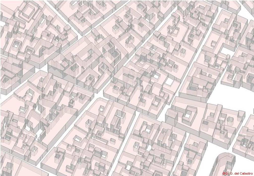
9 The buildings are defined as sub parcels, as volume constructed. Cadastral cartography, even in only 2D, has the volumetric information of the buildings by number of plants in roman numerals in their maps. ( II, -I+VI)


10 The Spanish cadastre is a pioneer public sector organisation in its facilitation of access and re-use of its data for free for both commercial and non-commercial purposes. sedecatastro.gob.es The Spanish Cadastral Service by internet gives cost-free, easy, rapid, 24-hour, 7 days a week access to cadastral data


11 It has evolved from being a government tax collection and a real estate security service to being a socially valuable tool since this data is used in an increasing number of application and new services. This approach has led progressively to a huge success in demand, with more than 8 millions of acces a day and more than 5,2 millions of certificates issued in 2011


12 WMS of the Spanish Cadastre: Free of charge For everybody 24h 7 days


13 . The subparcels are created - by their nature (IP pool, JD Garden, TZA terrace,...) -or by number of plants, for example --I+IV basement plus four plants, - - II+SOP+X two basements plus veranda plus ten floors,..


14 In the model, the texts (the numbers) that we see in the map are attributes of the construction layer CONSTRU geometry of the layer "CONSTRU" defines the different volumes of the buildings and other characteristics as terraces, gardens, swimming pools, etc

15 With all this, How to build the 3D? CONSTRU layer The WMS service of the SDGC is developed with our own media and technology, which allow us to manipulate information obtained directly from the spatial selection of the graphic database in vector format, and to generate the resulting image of the map with the characteristics of the symbols and representations that we want to. The CONSTRU layer is going to serve as a basis for use in the 3D representation.


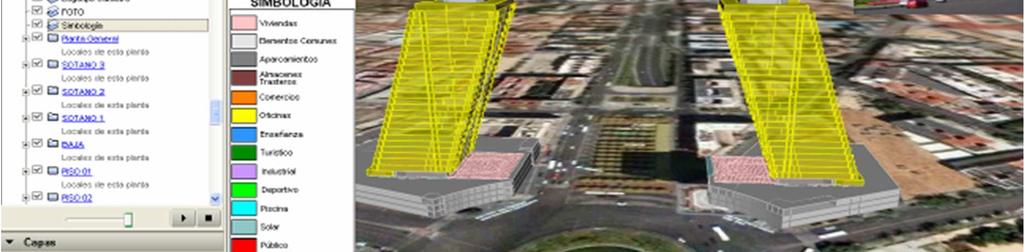
16 We have defined two new layers in the service WMS, providing two different solutions one using a shading to give highlight aspect to the buildings and other that is the representation in Cavalier perspective each constructive element. 3D REPRESENTATION IN THE WMS Shadow using CONSTRU3D layer WMS Catastro Prespective using EDIFICIOS BUILDINGS layer


17 Shadow using CONSTRU3D Layer Cadastral Cartography sub parcels that have as volumetric attribute floors above ground level Normal representation shift from the geometry of these compounds in the Southeast direction semitransparent fill in grey sub parcels that have as volumetric attribute floors above ground level Normal representation

18 Prespective using EDIFICIOS BUILDINGS layer we order the sub parcels from North to South each sub parcel is drawn in its real position with semi-transparent for each pair of consecutive coordinates that make up the sub parcel, we construct a parallelogram in the North-South direction and with different scale by a factor multiplied by the number of floors above ground level. we draw the cover of the generated prism. It is a object with the same geometry of the base but with a shift towards the North of the image, based on a factor by the number of plants
19


20 The SDGC has developed a vector 3D modeling by parcel in KML format. based on -the 3D component of the constructions that it is collected as attribute of the sub parcels and -the geometry of the premises, This modeling is not stored in the database, it is performed in "real time" on the basis of the vector information of the geometry of objects.


21 3D MODELING 3D Model General floor Based on modeling by extrusion on the basis of cadastral mapping and the attribute of construction geometry to get the "z" component 3D Model By floors based on the generation of independent units models with the vector information of the cadastral sketch by plants


22 3D Model of General floor We use the cadastral cartography in vector format of each parcel. And the number of plants, multiplied by 3 (that it is what we have estimated a priori, in meters, as the average height of eachextrusión plant), hacia el interior Modeling by extrusión a 3D model by extrusion is generated for each sub parcel of the parcel.


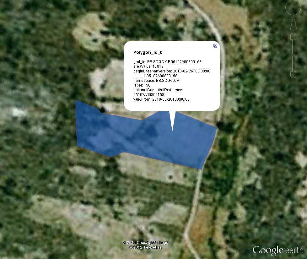
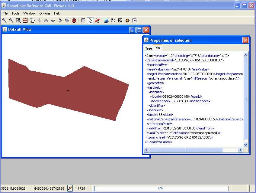
23 Structure of KML File of 3D Model of general floor The resulting KML has a link with the cadastral reference to get all the free cadastral data of the parcel hiperlink
24 3D MODEL by floor We use the information of the FXCC


25 Each part of the building can be then geometrically represented in three Modelización 3D de un local dimensions within the physical space in the building. Roof: horizontal plane geometry of the local 3 metres above the ground There are some exceptions, For example in the case of the terraces the objects are defined by a floor and walls of 1.5 meters in height. Walls: as rectangular vertical planes of 3 meters in height of each pair of coordinates Soil: horizontal plane geometry 2D surface


26 Even, we can give to each unit a color depending on its use, owner, value o any attribute
27

28 Time Catastro 4D We offer also exchange format in KML in 4D

29
30 CONCLUSIONS before INSPIRE The cartography of the Spanish cadastre can by modeled in 3D. the idea of representing 3D objects in services WMS, is a novelty for us and provides a better interpretation of the city Automatic extrusion of 3D data based on simple schemas that allows to reconstruct a large amount of data, offers a good solution to the demand for such products, increasingly requested by users. For cadastral purposes, we don t need to store complex 3D models with description of textures, openings,.simple 3D visualisation is enough for our current users!!!!


31 And then INSPIRE As main buildings data provider of the Spanish Spatial Data infrastructure We have participed in the INSPIRE Thematic Working Group of Buildings Cadastral data of buildings Topografic data of buildings


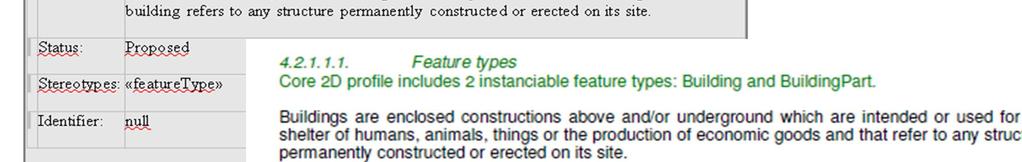
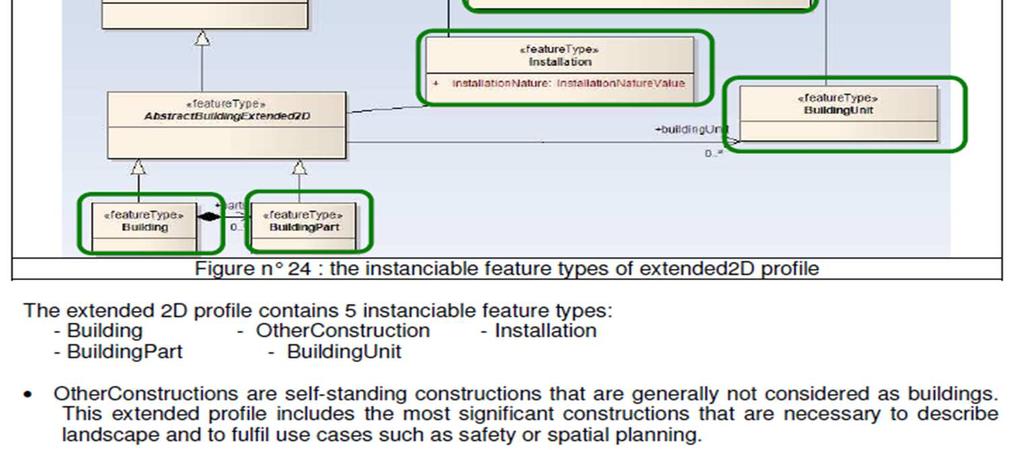
32 INSPIRE status 5 application schemas Base package : Common semantics on Abstract Building Common data types and code lists Core 2D Base information + 2D geometry Core 3D Base information + mandatory 3D geometry 4 LoDs of City GML allowed 2D geometry possible (voidable) Extended 2D Core 2D + additional semantics Extended 3D Core 3D + additional semantics + boundary surfaces, openings, interior + textures Only these 3 AS in IR
33 IN S P IR E c o re 2 D


34


35


36 We will have to build the building from the buildings parts, and to create an identifier


37 We will have to adapt our complete classification of buildings to a much more simple classification or to extend the INSPIRE code list


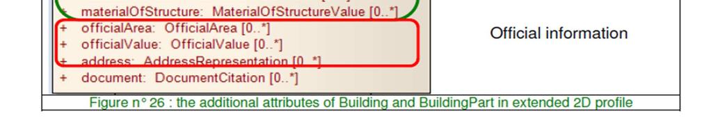
38 If we apply the core model of INSPIRE, we will offer very few data regarding those that we would have been able to provide
39 INSPIRE core 3D


40 We can not give 3D data in INSPIRE model, because we use KML (visualisation format) and not City GML (topologic and semantic model). City GML stores geometry, topology and semantics in its building model
41 INSPIRE EXTENDED 2D


42
![Floor distribution: [-2, 8 ] for a building having 2 underground floors and 8 floors above ground FloorDescription: - floor range [0,0] -](/docs-images/72/66774332/images/43-2.jpg "currentuse: trade - height : 3 m - document: sketch of ground floor - number of dwellings : 0 - openingarea: 40 m2 to descibe a ground")

43 Floor distribution: [-2, 8 ] for a building having 2 underground floors and 8 floors above ground FloorDescription: - floor range [0,0] - currentuse: trade - height : 3 m - document: sketch of ground floor - number of dwellings : 0 - openingarea: 40 m2 to descibe a ground floor occupied by shops. FloorDescription: - floor range [1,7] - currentuse: residential - height : 3 m - document: sketch of first floor - number of dwellings : 6 (6 dwellings per floor) - openingarea: 50 m2 To describe the 7 floors above ground floor, if all these floors are similar

44 INSPIRE EXTENDED 2D


45 In the Spanish Cadastre the building units are important The Spanish Cadastre is a Fiscal Cadastre and the value of each unit is the basic for many taxes as the Local Property tax To be able to offer our buiding units in INSPIRE model we should give one identifier of every unit.


46 INSPIRE Extended 3D To be able to offer our buiding units in INSPIRE 3D model we should give 3D geometry and one identifier of every 3D unit.
47 CONCLUSIONS after INSPIRE We will have to build the building from the buildings parts, and to create an identifier We will have to adapt our complete classification of buildings to a much more simple classification or to extend INSPIRE code list. If we apply the mandatory core 2D model of INSPIRE (most likely scenario for short term), we will offer very few data regarding those that we would have been able to provide. May be in the future, we can apply extended 2D model and offer more 3D related information via floor description, floor distribution and documentation. Our way to provide 3D visualisation of buildings in KML (automatic extrusion of 2D data + height) is not enough to fill the 3D model of INSPIRE; however, we should keep this kind of view services that is of great interest for our users To be able to offer our buiding units in INSPIRE model, we should give geometry (2D or 3D) and identifier of every unit (?)

48 Thank you for your atention
3D Modeling and Representation of the Spanish Cadastral Cartography
 3D Modeling and Representation of the Spanish Cadastral Cartography José Miguel OLIVARES GARCÍA, Luis Ignacio VIRGÓS SORIANO and Amalia VELASCO MARTÍN-VARÉS, Spain Key words: Cadastre Mapping, Web Map
3D Cadastral System Functionalities for 5D Multi- Purpose LIS
 3D Cadastral System Functionalities for 5D Multi- Purpose LIS ΕΣΠΑ 2007-2013, Δράση«Διμερής Ε&Τ Συνεργασία Ελλάδας- Ισραήλ 2013-2015» YΠOYPΓEIO ΠAΙΔΕΙΑΣ ΚΑΙ ΘΡΗΣΚΕΥΜΑΤΩΝ Γ.Γ.Ε.Τ. ΕΥΔΕ - ΕΤΑΚ Outline 5DMuPLIS
Questionnaire 3D-Cadastres: status November 2010
 Questionnaire 3D-Cadastres: status vember This questionnaire is an activity of the FIG working group 3D-Cadastres -. The purpose of the survey is to make a world-wide inventory of the status of 3D-Cadastres
Selective 4D modelling framework for spatialtemporal Land Information Management System
 Selective 4D modelling framework for spatialtemporal Land Information Management System A. Doulamis, S. Soile, N. Doulamis, C. Chrisouli, N. Grammalidis, K. Dimitropoulos C. Manesis, C. Potsiou, C. Ioannidis
Questionnaire 3D-Cadastres: status November 2010
 Questionnaire 3D-Cadastres: status vember 2010 France This questionnaire is an activity of the FIG working group 3D-Cadastres 2010-2014. The purpose of the survey is to make a world-wide inventory of the
Unwrapping of Urban Surface Models
 Unwrapping of Urban Surface Models Generation of virtual city models using laser altimetry and 2D GIS Abstract In this paper we present an approach for the geometric reconstruction of urban areas. It is
Volume and Surface Area of Rectangular Prisms All Boxed Up
 Volume and Surface Area of Rectangular Prisms SUGGESTED LEARNING STRATEGIES: Activating Prior Knowledge, Use Manipulatives, Visualization, Group Presentation, Think/Pair/Share The shape in Figure is a
Visualization Principles in 3D Cadastre: A First Assessment of Visual Variables
 Visualization Principles in 3D Cadastre: A First Assessment of Visual Variables Chen WANG, Jacynthe POULIOT and Frédéric HUBERT, Canada Keywords: 3D, cadastre, visualization, visual variables SUMMARY This
A PROPOSED METHOD FOR GENERATING,STORING AND MANAGING LARGE AMOUNTS OF MODELLING DATA USING SCRIPTS AND ON-LINE DATABASES
 Ninth International IBPSA Conference Montréal, Canada August 15-18, 2005 A PROPOSED METHOD FOR GENERATING,STORING AND MANAGING LARGE AMOUNTS OF MODELLING DATA USING SCRIPTS AND ON-LINE DATABASES Spyros
BASIC MATHEMATICS FOR CADASTRAL MAPPING
 BASIC MATHEMATICS FOR CADASTRAL MAPPING Chapter 5 2015 Cadastral Mapping Manual 5-1 Introduction Data which a mapper must use to solve problems comes from a myriad of sources both new and old. The general
TOPICALITY AND USING OF CIVIL ENGINEERING PROJECTS VISUALIZATION
 TOPICALITY AND USING OF CIVIL ENGINEERING PROJECTS VISUALIZATION Konstantinas Stanislovas Danaitis 1, Ana Usovaite 2 1,2 Vilnius Gediminas Technical University, Saulėtekio ave. 11, LT-10223 Vilnius, Lithuania.
PLANNED VS. REAL CITY
 LANNED VS. REAL CITY 3D GIS for Analyzing the Transformation of Urban Morphology ilar Garcia-Almirall, Francesc Valls Dalmau, Montserrat Moix Bergada {pilar.garcia-almirall, francesc.valls, montserrat.moix}
The Existing Legal Cadastre in Israel Introduced in 1928 Based on Torrens principles (Registration of Title) Two-Dimensional Surface properties Owners
 Two-Dimensional Surface properties Owners") 3D Cadastre GIS Geometry, Topology and other Technical Considerations Presented by Moshe Benhamu & Shay Cherutil Written by: Nurit Peres & Moshe Benhamu FIG Working Week, May 07, 2009, Eilat Agenda Introduction
3D Cadastre GIS Geometry, Topology and other Technical Considerations Presented by Moshe Benhamu & Shay Cherutil Written by: Nurit Peres & Moshe Benhamu FIG Working Week, May 07, 2009, Eilat Agenda Introduction
A New Dimension to Land Development and Subdivision Design: Application of AutoCAD Civil 3D
 A New Dimension to Land Development and Subdivision Design: Application of AutoCAD Civil 3D Tarig Ali College of Engineering and Computer Science University of Central Florida Orlando, Florida taali@mail.ucf.edu
MATHEMATICS MAT1L. Grade 9, Essentials
 MATHEMATICS MAT1L Grade 9, Essentials Volume Lesson 16 Lesson Sixteen Concepts Explore and describe situations from everyday life and the workplace that require calculating or measurement of volume. Investigate
Lecture 4 Form & Space Form Defines Space
 Islamic University-Gaza Faculty of Engineering Architectural Department Principles of Architectural and Environmental Design -EARC 2417 Lecture 4 Form & Space Form Defines Space Instructor: Dr. Suheir
_Tutorials. Arcmap. Linking additional files outside from Geodata
 _Tutorials Arcmap Linking additional files outside from Geodata 2017 Sourcing the Data (Option 1): Extracting Data from Auckland Council GIS P1 First you want to get onto the Auckland Council GIS website
An Urban Planning Web Viewer based on AJAX *
 An Urban Planning Web Viewer based on AJAX * Miguel R. Luaces, David Trillo Pérez, J. Ignacio Lamas Fonte, Ana Cerdeira-Pena Database Laboratory, University of A Coruña, Campus de Elviña s/n. A Coruña,
The cadastral data and standards based on XML in Poland
 The cadastral data and standards based on XML in Poland Jarosław Bydłosz, Piotr Parzych AGH University of Science and Technology Cracow, Poland 1 XML XML Extensible Markup Language Extensible Markup Language
Data transformation Addresses
 Data transformation Addresses according to INSPIRE Ing. Michal Med ČÚZK April 17, 2015 1 Introduction 2 3 4 Introduction About data and services INSPIRE harmonised data and download and view service were
Remote sensing techniques applied to seismic vulnerability assessment
 Remote sensing techniques applied to seismic vulnerability assessment JJ Arranz (josejuan.arranz@upm.es), Y. Torres (y.torres@upm.es), A. Haghi (a.haghi@alumnus.upm.es), J. Gaspar (jorge.gaspar@upm.es)
Rapid Modeling of Digital City Based on Sketchup
 Journal of Mechanical Engineering Research and Developments ISSN: 1024-1752 Website: http://www.jmerd.org Vol. 38, No. 1, 2015, pp. 130-134 J. Y. Li *, H. L. Yuan, & C. Reithmeier Department of Architectural
Alaska Mathematics Standards Vocabulary Word List Grade 7
 1 estimate proportion proportional relationship rate ratio rational coefficient rational number scale Ratios and Proportional Relationships To find a number close to an exact amount; an estimate tells
TWG BU Workshop. INSPIRE Conference.
 TWG BU Workshop INSPIRE Conference dominique.laurent@ign.fr Plan of presentation TWG BU members General methodology Existing standards Use cases user requirements Modelling approach Open issues TWG BU
Visualization/dissemination of 3D Cadastral Information
 Presented at the FIG Congress 2018, May 6-11, 2018 in Istanbul, Turkey Visualization/dissemination of 3D Cadastral Information 9-5-2018 Barbara Cemellini, Rod Thompson, Marian de Vries, Peter van Oosterom
A DATA DRIVEN METHOD FOR FLAT ROOF BUILDING RECONSTRUCTION FROM LiDAR POINT CLOUDS
 A DATA DRIVEN METHOD FOR FLAT ROOF BUILDING RECONSTRUCTION FROM LiDAR POINT CLOUDS A. Mahphood, H. Arefi *, School of Surveying and Geospatial Engineering, College of Engineering, University of Tehran,
Data Specification Buildings
 Data Specification Buildings KEN INSPIRE Workshop INSPIRE Theme Buildings Status after consultation and testing dominique.laurent@ign.fr Plan of presentation General methodology, existing data and standards
Lecture 3 Form & Space Form Defines Space
 Islamic University-Gaza Faculty of Engineering Architecture Department Principles of Architectural and Environmental Design -EARC 2417 Lecture 3 Form & Space Form Defines Space Instructor: Dr. Suheir Ammar
TOPOSCOPY, A CLOSE RANGE PHOTOGRAMMETRIC SYSTEM FOR ARCHITECTS AND LANDSCAPE DESIGNERS
 TOPOSCOPY, A CLOSE RANGE PHOTOGRAMMETRIC SYSTEM FOR ARCHITECTS AND LANDSCAPE DESIGNERS A. C. Groneman-van der Hoeven Bureau Toposcopie, Bachlaan 78, 6865 ES Doorwerth, The Netherlands. info@toposcopie.nl
RECOMMENDATION ITU-R P DIGITAL TOPOGRAPHIC DATABASES FOR PROPAGATION STUDIES. (Question ITU-R 202/3)
") Rec. ITU-R P.1058-1 1 RECOMMENDATION ITU-R P.1058-1 DIGITAL TOPOGRAPHIC DATABASES FOR PROPAGATION STUDIES (Question ITU-R 202/3) Rec. ITU-R P.1058-1 (1994-1997) The ITU Radiocommunication Assembly, considering
Rec. ITU-R P.1058-1 1 RECOMMENDATION ITU-R P.1058-1 DIGITAL TOPOGRAPHIC DATABASES FOR PROPAGATION STUDIES (Question ITU-R 202/3) Rec. ITU-R P.1058-1 (1994-1997) The ITU Radiocommunication Assembly, considering
S206E Lecture 15, 4/27/2018, Rhino 3D, Grasshopper, Shanghai Tower modeling
 S206E057 -- Lecture 15, 4/27/2018, Rhino 3D, Grasshopper, Shanghai Tower modeling Copyright 2018, Chiu-Shui Chan. All Rights Reserved. Creation of high-rise building models has a typical algorithm, which
2011 Bentley Systems, Incorporated. Bentley Descartes V8i Advancing Information Modeling For Intelligent Infrastructure
 Bentley Descartes V8i Advancing Information Modeling For Intelligent Infrastructure Agenda Why would you need Bentley Descartes? What is Bentley Descartes? Advanced Point Cloud Workflows Advanced Terrain
Shadows in the graphics pipeline
 Shadows in the graphics pipeline Steve Marschner Cornell University CS 569 Spring 2008, 19 February There are a number of visual cues that help let the viewer know about the 3D relationships between objects
Covering & Surrounding
 Covering & Surrounding Two-Dimensional Measurement and Three-Dimensional Measurement Name: Hour: Table of Contents Investigation 1 Investigation 1.1 page 3 Investigation 1.2 page 7 Investigation 1.3 page
3D Data Modelling at Esri. Paul Hardy Business Development Consultant Esri Europe
 3D Data Modelling at Esri Paul Hardy phardy@esri.com Business Development Consultant Esri Europe Users of 3D GIS Local government Facilities management Civil engineering 3D GIS Defense / Public Safety
VISUALIZATION PRINCIPLES IN 3D CADASTRE: A FIRST ASSESSMENT OF VISUAL VARIABLES
 VISUALIZATION PRINCIPLES IN 3D CADASTRE: A FIRST ASSESSMENT OF VISUAL VARIABLES Ph.D. Candidate Chen Wang Dr. Jacynthe Pouliot Dr. Frédéric Hubert Department of Geomatics, Laval University, Quebec, Canada
Introduction to INSPIRE. Network Services
 Introduction to INSPIRE. Network Services European Commission Joint Research Centre Institute for Environment and Sustainability Digital Earth and Reference Data Unit www.jrc.ec.europa.eu Serving society
Realworks Software. A Powerful 3D Laser Scanning Office Software Suite
 TECHNICAL NOTES Realworks Software A Powerful 3D Laser Scanning Office Software Suite Trimble RealWorks is a powerful office software that imports rich data from your 3D laser scanning instrument and transforms
AUTOMATIC EXTRACTION OF BUILDING FEATURES FROM TERRESTRIAL LASER SCANNING
 AUTOMATIC EXTRACTION OF BUILDING FEATURES FROM TERRESTRIAL LASER SCANNING Shi Pu and George Vosselman International Institute for Geo-information Science and Earth Observation (ITC) spu@itc.nl, vosselman@itc.nl
CityGML Experience: From Validation to Database Management. Kean Huat SOON, Eric LOW, Zhen Hao NG and Victor KHOO
 Experience: From Validation to Database Management Kean Huat SOON, Eric LOW, Zhen Hao NG and Victor KHOO Outline : WOG 3D National Topographic Mapping Project Validation Process Management of Data in DBMS
Unit E Geometry Unit Review Packet
 Unit E Geometry Unit Review Packet Name Directions: Do ALL (A) Questions. Check Your Answers to (A) Questions. If ALL (A) Questions are correct, skip (B) Questions and move onto next I can statement. If
Slide 1. Bentley Descartes V8i. Presented by: Inga Morozoff, Bentley
 Slide 1 Bentley Descartes V8i Presented by: Inga Morozoff, Bentley Slide 2 Agenda What is Bentley Descartes? Where is it used? Features Benefits Live demo Questions and Answers 2 WWW.BENTLEY.COM Slide
From 2D to 3D at Esri
 From 2D to 3D at Esri OGC/EuroSDR workshop on CityGML in National Mapping Paul Hardy phardy@esri.com Business Development Consultant National Mapping & Cadastre Esri 3D GIS Visualize Manage Share Analyze
TIPS4Math Grades 4 to 6 Overview Grade 4 Grade 5 Grade 6 Collect, Organize, and Display Primary Data (4+ days)
") Collect, Organize, and Display Primary Data (4+ days) Collect, Organize, Display and Interpret Categorical Data (5+ days) 4m88 Collect data by conducting a survey or an experiment to do with the 4m89 Collect
Collect, Organize, and Display Primary Data (4+ days) Collect, Organize, Display and Interpret Categorical Data (5+ days) 4m88 Collect data by conducting a survey or an experiment to do with the 4m89 Collect
INSPIRE & Environment Data in the EU
 INSPIRE & Environment Data in the EU Andrea Perego Research Data infrastructures for Environmental related Societal Challenges Workshop @ pre-rda P6 Workshops, Paris 22 September 2015 INSPIRE in a nutshell
ATTRACTING FOREIGN INVESTMENTbasis
 ATTRACTING FOREIGN INVESTMENTbasis for strengthening growth and employment in local government MUNICIPALITY OF INDJIJA www.indjija.net STRATEGIC LOCATION MUNICIPALITY OF INDJIJA www.indjija.net International
Peoria County Front Desk Map Application
 Peoria County Front Desk Map Application Quick Guide, 2017 At a First Glance This guide will tell users all they need to know about the Peoria County Front Desk application which can be found on the Peoria
From Floor Plans to Condominium Rights Through an Augmented Reality Approach
 From Floor Plans to Condominium Rights Through an Augmented Reality Approach Gerhard NAVRATIL, Marco SCHWAI, Stefan VOLLNHOFER, Philip KONTUREK and Ioannis GIANNOPOULOS, Austria Key words: Austria, condominium,
From 2D to 3D at Esri
 From 2D to 3D at Esri Paul Hardy, Esri Inc phardy@esri.com, Cambridge, UK SHORT PAPER This short paper provides an overview of the 3D capabilities of a modern GIS, illustrated by the Esri ArcGIS system,
Bringing Singapore to life in 3D
 Bringing Singapore to life in 3D Dr Victor Khoo, Deputy Director Singapore Land Authority Bringing Singapore to life in 3D ESRI Singapore UC 2016 Dr. Victor Khoo Singapore Land Authority SLA 2016 RESTRICTED
Automatic generation of 3-d building models from multiple bounded polygons
 icccbe 2010 Nottingham University Press Proceedings of the International Conference on Computing in Civil and Building Engineering W Tizani (Editor) Automatic generation of 3-d building models from multiple
STATE OF CONNECTICUT DEPARTMENT OF CONSUMER PROTECTION 450 Columbus Blvd, Suite 901 Hartford, CT 06103
 STATE OF CONNECTICUT DEPARTMENT OF CONSUMER PROTECTION 450 Columbus Blvd, Suite 901 Hartford, CT 06103 RESIDENTIAL PROPERTY CONDITION DISCLOSURE REPORT The Uniform Property Condition Disclosure Act (Connecticut
Development of Geospatial Smart Cities and Management
 Presented at the FIG Congress 2018, May 6-11, 2018 in Istanbul, Turkey Development of Geospatial Smart Cities and Management (E. Yılmaz, F. Kartal, E. Uçar, K. Eren) FIG2018 - Istanbul, 8 th May 2018 1
Logan City GIS Master Plan. Term Project. Colton Smith. David Tarboton CEE 6440
 Logan City GIS Master Plan Term Project Colton Smith David Tarboton CEE 6440 November 29, 2012 Introduction Logan City has lots of data available for streets, canals, trails, zoning maps, and municipalities.
Keywords: 3D-GIS, R-Tree, Progressive Data Transfer.
 3D Cadastres 3D Data Model Visualisation 3D-GIS IN NETWORKING ENVIRONMENTS VOLKER COORS Fraunhofer Institute for Computer Graphics Germany ABSTRACT In this paper, we present a data model for 3D geometry
GEOMETRY. slide #3. 6th Grade Math Unit 7. 6th Grade Unit 7: GEOMETRY. Name: Table of Contents. Area of Rectangles
 Name: 6th Grade Math Unit 7 GEOMETRY 2012 10 17 www.njctl.org 1 Table of Contents Area of Rectangles Area of Parallelograms Area of Triangles Area of Trapezoids Mixed Review Area of Irregular Figures Area
3D TOPOLOGY FOR MODELLING OF URBAN STRUCTURES
 3D TOPOLOGY FOR MODELLING OF URBAN STRUCTURES Tarun Ghawana & Sisi Zlatanoa Delft Uniersity of Technology Challenge the future Increased awareness of underground information Ludig Emgard Jakob Beetz 2
Detailed analysis + Integration plan
 Outline Integration methodology Detailed analysis + Integration plan Conclusions 2 Outline Integration methodology Detailed analysis + Integration plan Conclusions 3 EULF-ISA Integration: methodology Phase
Math 1 Plane Geometry Part 1
 Math 1 Plane Geometry Part 1 1 Intersecting lines: When two lines intersect, adjacent angles are supplementary (they make a line and add up to 180 degrees, and vertical angles (angles across from each
SketchUp Quick Start For Surveyors
 SketchUp Quick Start For Surveyors Reason why we are doing this SketchUp allows surveyors to draw buildings very quickly. It allows you to locate them in a plan of the area. It allows you to show the relationship
Oklahoma Learning Pathways
 BUI L F OKL ORT AHO MA 2015 2016 Oklahoma Learning Pathways Table of Contents Grade 3...3 Grade 4...5 Grade 5...8 Grade 6... 11 Grade 7... 15 Grade 8... 19 Algebra Readiness...22 Algebra I...25 Geometry...28
Methodological approach for cross-theme harmonization of Polish spatial data sets the case study for the Annex I themes
 Methodological approach for cross-theme harmonization of Polish spatial data sets the case study for the Annex I themes Elżbieta Bielecka, Agnieszka Zwirowicz-Rutkowska, Alina Kmiecik, Marek Brylski, Magdalena
THANK YOU FOR YOUR PURCHASE!
 THANK YOU FOR YOUR PURCHASE! The resources included in this purchase were designed and created by me. I hope that you find this resource helpful in your classroom. Please feel free to contact me with any
COMBINING HIGH SPATIAL RESOLUTION OPTICAL AND LIDAR DATA FOR OBJECT-BASED IMAGE CLASSIFICATION
 COMBINING HIGH SPATIAL RESOLUTION OPTICAL AND LIDAR DATA FOR OBJECT-BASED IMAGE CLASSIFICATION Ruonan Li 1, Tianyi Zhang 1, Ruozheng Geng 1, Leiguang Wang 2, * 1 School of Forestry, Southwest Forestry
ARTS DISTRICT 2018 E. 8 TH STREET, LOS ANGELES, CA
 DOWNTOWN LOS ANGELES ARTS DISTRICT 2018 E. 8 TH STREET, LOS ANGELES, CA INVESTMENT / OWNER-USER OPPORTUNITY MARKETING BROCHURE WWW.LAREALTYPARTNERS.COM PROPERTY SUMMARY PROPERTY OVERVIEW 2017 E. 8TH STREET
RealWorks Software. A Powerful 3D Laser Scanning Office Software Suite
 TECHNICAL NOTES RealWorks Software A Powerful 3D Laser Scanning Office Software Suite Trimble RealWorks is a powerful office software that imports rich data from your 3D laser scanning instrument and transforms
3D CITY MODELLING WITH CYBERCITY-MODELER
 1 3D CITY MODELLING WITH CYBERCITY-MODELER Kilian Ulm 1 and Daniela Poli 1 1. CyberCity AG, Zurich, Switzerland, (kilian.ulm, daniela.poli)@cybercity.tv ABSTRACT 3D city models using stereo aerial-/satellite
Previously... contour or image rendering in 2D
 Volume Rendering Visualisation Lecture 10 Taku Komura Institute for Perception, Action & Behaviour School of Informatics Volume Rendering 1 Previously... contour or image rendering in 2D 2D Contour line
Chapter 8 Visualization and Optimization
 Chapter 8 Visualization and Optimization Recommended reference books: [1] Edited by R. S. Gallagher: Computer Visualization, Graphics Techniques for Scientific and Engineering Analysis by CRC, 1994 [2]
INSPIRE overview and possible applications for IED and E-PRTR e- Reporting Alexander Kotsev
 INSPIRE overview and possible applications for IED and E-PRTR e- Reporting Alexander Kotsev www.jrc.ec.europa.eu Serving society Stimulating innovation Supporting legislation The European data puzzle 24
AUTOMATIC GENERATION OF 3-D BUILDING MODELS FROM BUILDING POLYGONS ON GIS
 AUTOMATIC GENERATION OF 3-D BUILDING MODELS FROM BUILDING POLYGONS ON GIS Kenichi Sugihara 1, Yoshitugu Hayashi 2 ABSTRACT When a real urban world is projected into 3-D virtual space, buildings are major
Web apps for INSPIRE: the ELISE Energy pilot example
 Web apps for INSPIRE: the ELISE Energy pilot example 6 September 2017 Authors: Daniele Francioli Giacomo Martirano Maria Teresa Borzacchiello Francesco Pignatelli Outline Overview of the ELISE Energy Pilot
Revit MEP 2013 Overview Day 1. William Johnson Senior MEP/AEC Application Specialist
 Revit MEP 2013 Overview Day 1 William Johnson Senior MEP/AEC Application Specialist CLASS SCHEDULE 9:00am Training Starts 10:30am 10:45am Morning Break 12:00pm 1:00pm Lunch Break 2:30pm 2:45pm Afternoon
Daylight and Sunlight Study 47 Gainsford Road, London E17 6QB
 Daylight and Sunlight Study 47 Gainsford Road, London E17 6QB 4 May 2016 Right of Light Consulting Burley House 15-17 High Street Rayleigh Essex SS6 7EW Tel: 0800 197 4836 DAYLIGHT AND SUNLIGHT STUDY 47
Dinwiddie County Public Schools Subject: Math 7 Scope and Sequence
 Dinwiddie County Public Schools Subject: Math 7 Scope and Sequence GRADE: 7 Year - 2013-2014 9 WKS Topics Targeted SOLS Days Taught Essential Skills 1 ARI Testing 1 1 PreTest 1 1 Quadrilaterals 7.7 4 The
Towards a 3D cadastre: where do cadastral needs and technical possibilities meet?
 Computers, Environment and Urban Systems 27 (2003) 395 410 www.elsevier.com/locate/compenvurbsys Towards a 3D cadastre: where do cadastral needs and technical possibilities meet? Jantien Stoter a, *, Martin
IB Mathematical Studies Revision Questions
 I Mathematical Studies Revision Questions 1. rectangular block of wood with face D leans against a vertical wall, as shown in the diagram below. = 8 cm, = 5 cm and angle ÂE = 8. Wall F D E 8º Find the
3 AXIS STANDARD CAD. BobCAD-CAM Version 28 Training Workbook 3 Axis Standard CAD
 3 AXIS STANDARD CAD This tutorial explains how to create the CAD model for the Mill 3 Axis Standard demonstration file. The design process includes using the Shape Library and other wireframe functions
Conceptual Design Modeling in Autodesk Revit Architecture 2010
 Autodesk Revit Architecture 2010 Conceptual Design Modeling in Autodesk Revit Architecture 2010 In building design, visualizing a form in the earliest stages enhances a designer s ability to communicate
I.B. Geometry. 3d- Figures min 218 marks
 I.. Geometry 3d- Figures 20-04-07 200 min 218 marks 1. In the diagram below, PQRS is the square base of a solid right pyramid with vertex V. The sides of the square are 8 cm, and the height VG is 12 cm.
Math Geometry FAIM 2015 Form 1-A [ ]
![Math Geometry FAIM 2015 Form 1-A [ ]](/thumbs/80/81205175.jpg "Math Geometry FAIM 2015 Form 1-A [ ]") Math Geometry FAIM 2015 Form 1-A [1530458] Student Class Date Instructions Use your Response Document to answer question 13. 1. Given: Trapezoid EFGH with vertices as shown in the diagram below. Trapezoid
Math Geometry FAIM 2015 Form 1-A [1530458] Student Class Date Instructions Use your Response Document to answer question 13. 1. Given: Trapezoid EFGH with vertices as shown in the diagram below. Trapezoid
Setting up the Ihlet Social Cadastre
 Setting up the Ihlet Social Cadastre Ihlet KHT Dr. Attila Molnár, GI consultant Bela Jarolics Rome, Italy TOPICS Goal of the project Architecture Database Solution Standards, communication Metadata Security
Area of Plane Shapes 1
 Area of Plane Shapes 1 Learning Goals Students will be able to: o Understand the broad definition of area in context to D figures. o Calculate the area of squares and rectangles using integer side lengths.
Review: Geometry. Area Composite Figures Surface Area Volume Fractional Edge Length 3-D Figures and Nets Coordinate Graphing
 Review: Geometry Area Composite Figures Surface Area Volume Fractional Edge Length 3-D Figures and Nets Coordinate Graphing Perimeter: the distance around a polygon. Area: the number of square units needed
TEST REVIEW: UNIT 8 Surface Area 2018
 Class: Date: TEST REVIEW: UNIT 8 Surface Area 2018 Find the area. The figure is not drawn to scale. 1. 5. Find the area. All lengths are in centimeters. Round answer to the nearest tenth. 2. 6. A can of
George used a decorative gate to connect the fencing around his backyard.
 Page 1 of 21 1. George used a decorative gate to connect the fencing around his backyard. Using the information on the diagram and assuming the top and bottom are parallel, is 40º 60º C) 120º D) 180º 2.
FAST PRODUCTION OF VIRTUAL REALITY CITY MODELS
 FAST PRODUCTION OF VIRTUAL REALITY CITY MODELS Claus Brenner and Norbert Haala Institute for Photogrammetry (ifp) University of Stuttgart Geschwister-Scholl-Straße 24, 70174 Stuttgart, Germany Ph.: +49-711-121-4097,
PARAMETERIZE URBAN DESIGN CODES WITH BIM AND OBJECT-ORIENTED PROGRAMMING
 R. Stouffs, P. Janssen, S. Roudavski, B. Tunçer (eds.), Open Systems: Proceedings of the 18th International Conference on Computer-Aided Architectural Design Research in Asia (CAADRIA 2013), 33 42. 2013,
Figure 1 Visualization of 3D-city models: left with CyberWalk, right with TerrainView
 Generation and visualization of 3D-city and facility models using CyberCity Modeler (CC-Modeler ) Prof. Dr. Armin GRUEN, Dr. Franz STEIDLER and Dr. Xinhua WANG Prof. Dr. Armin GRUEN, ETH Zurich, c/o Chair
IT Infrastructure for BIM and GIS 3D Data, Semantics, and Workflows
 IT Infrastructure for BIM and GIS 3D Data, Semantics, and Workflows Hans Viehmann Product Manager EMEA ORACLE Corporation November 23, 2017 @SpatialHannes Safe Harbor Statement The following is intended
A Development Proposal. by Demari Developers
 A Development Proposal by Demari Developers Company Profile Excellent Track record for over 25 years Amongst Market leaders in its field in Cyprus Pioneering Product Diversification Demari Property Management
Rendering Grass Terrains in Real-Time with Dynamic Lighting. Kévin Boulanger, Sumanta Pattanaik, Kadi Bouatouch August 1st 2006
 Rendering Grass Terrains in Real-Time with Dynamic Lighting Kévin Boulanger, Sumanta Pattanaik, Kadi Bouatouch August 1st 2006 Goal Rendering millions of grass blades, at any distance, in real-time, with:
Geodatabases. Dr. Zhang SPRING 2016 GISC /03/2016
 Geodatabases Dr. Zhang SPRING 2016 GISC 1401 10/03/2016 Using and making maps Navigating GIS maps Map design Working with spatial data Spatial data infrastructure Interactive maps Map Animations Map layouts
BCA BUILDING CLASSIFICATIONS
 BCA BUILDING CLASSIFICATIONS Classification of Buildings Intent of classifications To categorise buildings of similar risk levels based on use, hazard and occupancy Classification is a process for understanding
Land Cover spatial datasets harmonization in Portugal using HALE
 Land Cover spatial datasets harmonization in Portugal using HALE Teresa Zuna, Alexandra Fonseca, Danilo Furtado, Ana Luísa Gomes, André Serronha, Paulo Patrício Introduction DGT is the entity responsible
The radius for a regular polygon is the same as the radius of the circumscribed circle.
 Perimeter and Area The perimeter and area of geometric shapes are basic properties that we need to know. The more complex a shape is, the more complex the process can be in finding its perimeter and area.
Investigation: Finding Relationships Between Area and Parallel Lines in Triangles
 Name: Date: Investigation: Finding Relationships Between Area and Parallel Lines in Triangles In this investigation you will discover a relationship between parallel lines and the area of a triangle. Specifically,
INDICATE: TOWARDS THE DEVELOPMENT OF A VIRTUAL CITY MODEL, USING A 3D MODEL OF DUNDALK CITY
 INDICATE: TOWARDS THE DEVELOPMENT OF A VIRTUAL CITY MODEL, USING A 3D MODEL OF DUNDALK CITY AM Aidan Melia 1 ; EN Eoin Nolan 1 ; Ruth Kerrigan 1 1: Integrated Environmental Solutions, Helix Building, West
CHANGING THE WORLD BY CONNECTING THE UNCONNECTED
 Market Trend CHANGING THE WORLD BY CONNECTING THE UNCONNECTED By Richard Schaap, Market Director Broadband Access at Introduction In a world where Internet access is coming to be regarded as an essential
STATE OF CONNECTICUT DEPARTMENT OF CONSUMER PROTECTION 165 Capitol Avenue Hartford, CT 06106
 STATE OF CONNECTICUT DEPARTMENT OF CONSUMER PROTECTION 165 Capitol Avenue Hartford, CT 06106 RESIDENTIAL PROPERTY CONDITION DISCLOSURE REPORT Name of Seller(s): Property Street Address: Property Municipality: