BIM for infrastructure make easy with Laser Scanner. 17 October Beng Chieh Quah Head of Marketing Asia Pacific
|
|
|
- Easter Crawford
- 6 years ago
- Views:
Transcription

1 BIM for infrastructure make easy with Laser Scanner 17 October 2016 Beng Chieh Quah Head of Marketing Asia Pacific


2 who is?


3 founded in 1981 NASDAQ since 1997 Global technology company Offering a range of 3D Portable Measurement and Imaging Solutions, that are DISRUPTIVE in Pricing, Features and Design

")
4 global presence sales presence in more than 80 countries Headquarter: USA Regional Office: Germany (EMEA) Singapore(APAC)
5 What is BIM and its trends What is Building Information Modeling (BIM) Building Information Modelling (BIM) is a three-dimensional (3-D) modelling technology that allows building professionals of various disciplines (architects, structural engineers, structural professionals, mechanical and electrical (M&E) engineers and contractors) to explore the building project digitally through an integrated process, before it is even built. Trends in Asia Pacifc Increasing use of BIM for Infrastructure by Government and Private Enterprise Increasing awareness of tangible benefits of BIM for co-ordinated decision making among stakeholders Increasing automation in construction process due to rising wages


6 Building Information Modelling Owners Architects BIM Builders & Fabricators BIM allows building professionals of various disciplines to Share Information Civil Engineers MEP Systems Engineers Structural Engineers


7 Building Information Modelling Previously drawing centric Data duplication errors Dumbing down of 3D data -> Now model based -> Single model - lots of views -> Maximum reuse of data -> Visualisation and Simulation

8 BIM Adoption BIM Adoption and Implementation 67% of current user of BIM for infrastructure report a positive ROI on their BIM investments. BIM experience user have gained 50% or greater of ROI Improved productivity Example: The construction of US$5.88B Australia s first fully automated transit rail in Sydney. BIM helping the project to streamline the workflows and improve efficiency which results saving cost, time, waste and better communication Source: McGraw-Hill Construction Business Value of BIM for Infrastructure

9 BIM Adoption rates in the world Brazil >15% Adoption rate Canada >48% Adoption rate US >75% Adoption Rate United Kingdom >45% Adoption rate France >42% Adoption rate Germany >28% Adoption rate China >5% Adoption rate Singapore >65% Adoption rate Korea >65% Adoption rate Japan >30% Adoption rate Source: McGraw Hill Construction 2013 Australia/New Zealand >49% Adoption rate
10 A Geographic/Geospatial Information System is a facility that enable users to capture, store, analyze and manage spatially referenced data Comprehensive GIS requires a means of - Data input - Data storage, retrieval and query - Data transformation, analysis, and modeling - Data reporting


11 Laser Scanning High speed laser scanning for detailed 3D images of complex environments and geometries A laser scanner constructs 360-degree point clouds of scanned surfaces to create 3D models
12 Overview of 3D Terrestrial Laser Scanner

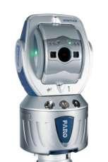
13 Overview of FARO 3D Laser Scanner High-speed 3D laser scanner for detailed measurement & documentation Produces detailed 3D images of complex environments & geometries in only a few minutes Integrated 70 megapixel camera for colorization of point clouds Captures up to 1 million points a second How does a Terrestrial Laser Scanner work? Uses phase shift technology Infrared light of varying length are projected outward Upon contact with an object, they are reflected back to the scanner x, y, z coordinates are calculated Scanner covers a 360 o x 300 o field of view
14 Laser Scanner How It Works 2

15 What Laser Scanner Benefits Laser Laser Scanner able to scan in long range up to 350m Light Weight, compact and mobile that you will take it with you wherever you go. Able to creates a precise in millimetre-accuracy at a blazing speed of 976,000 measurement points per second Reduce time and laborious in documenting existing building infrastructures for building modelling


16 As-Built Model Create fully editable 3D CAD models directly from point cloud or mesh data using realtime accuracy analysis tools Extracting Feature Information and 3D Feature Modeling Surveying As-Built As-Built 3D Feature Modeling Various Feature Modeling Wizards Accuracy Confirmation Exporting to Downstream


17 Deformation Monitoring Terrain & Retainer Wall Monitoring Quick and easy identification using 3D colour mapping deviation analysis or Cross Sectional with required colour spectrum


18 Tank and Chimney analysis Deformation analysis Roundness & straightness analysis Cross Sectional Measurements

19 A Geographic/Geospatial Information System is a facility that enable users to capture, store, analyze and manage spatially referenced data Comprehensive GIS requires a means of - Data input - Data storage, retrieval and query - Data transformation, analysis, and modeling - Data reporting


20 Advantages of Cloud Data Sharing Time & cost savings Mobility Real time feedback Archival without data loss


21 SCENE WebShare Cloud: a cloudbased hosting solution from FARO for easy and secure sharing of scan data worldwide via the internet

22 Success stories Infrastructure Monitoring: Tunneling made easy with FARO 3D LS Solution Company : Beijing Urban Construction Exploration & Surveying Design Research Institue Projects for railway construction and monitoring of tunnel deformation Providing surveying appraisals for clients for quality control Challenges with using traditional solution Multiple point data acquisition is slow and time consuming Data collected is incomplete due to limited number of points Results Reduce data acquisition time by more than 50% (down to 4hours) Improve productivity and accuracy

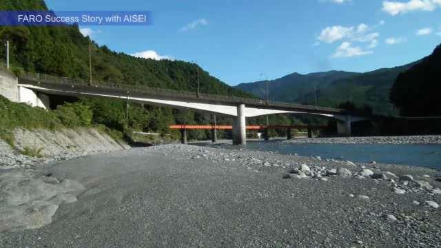
23 Success stories Infrastructure Monitoring: FARO s 3D Laser Scanning Technology Used to Detect Instability in Urban Structures Company : Aisei Ltd (Japan) Monitored Urban old Infrastructure and reinforced or repaired before a breakdown occurs inspects, investigates, and analyze urban structures for possible deterioration Challenges with using traditional solution Assess many bridges without an original design blueprint in hand Manual measurements is risky to accomplish and often inaccessible areas Results Improve operators safety Assess the condition of infrastructure more accurately and quickly with digital information Increase efficiency by using less resources per project

24 Conclusion The advancement and numerous benefits of BIM solutions have helped to empower the Private Enterprises, Government and the users with more accurate and real time data. In addition, the workflow has been simplified and accelerated with the advancement of 3D Laser scanning technology today: Complex infrastructure projects completed with high ROI Resource optimization - fast and precise scanning up to 1 million points per second Use of Cloud storage and sharing technology to improve efficiency real time and mobile
25


26 THANK YOU FOR ATTENDING @FAROtechnologies /FAROtechnologies youtube/farotechnologies
3D Terrestrial Laser Scanner Innovative Applications for 3D Documentation
 3D Terrestrial Laser Scanner Innovative Applications for 3D Documentation Rodney Chaffee Head of Sales, FARO Asia Pacific 3D Laser Scaning Market 2017 2.3 Billion $ 2012 1.3 Billion $ CAGR : > 12% Source:
Explore Laser Scanning in As-Built Survey. Vijay Chowdhary SE: BIM/CIM
 Explore Laser Scanning in As-Built Survey Vijay Chowdhary SE: BIM/CIM About FARO The world leader in portable 3-D measurement and imaging technology EMEA Headquarters Korntal-Münchingen, Germany APAC Headquarters
Innovation. lidarnews.com. volume 3 issue 5. Points clouds and terrain models support rail project. Structured light scanning for human head modeling
 volume 3 issue 5 LIDAR lidarnews.com SCALABILITY Points clouds and terrain models support rail project EXPRESSION Structured light scanning for human head modeling FLUCTUATION Scanning moving objects using
3D Scanning Technology in the Transportation Infrastructure: Case Studies from Around the Globe
 John Whitehead Director of Sales, Asia-Pacific JANUARY 2018 3D Scanning Technology in the Transportation Infrastructure: Case Studies from Around the Globe Overview What does 3D Scanning have to do with
Crossrail: A Case Study in BIM (Draft 26 th July 2013)
") Crossrail: A Case Study in BIM (Draft 26 th July 2013) Crossrail: A Case Study in BIM Malcolm Taylor Crossrail Head of Technical Information 29 th October 2013 Agenda Briefly set the scene What BIM in
Crossrail: A Case Study in BIM (Draft 26 th July 2013) Crossrail: A Case Study in BIM Malcolm Taylor Crossrail Head of Technical Information 29 th October 2013 Agenda Briefly set the scene What BIM in
Trimble 3D Laser Scanning TRANSFORMING THE WAY THE WORLD WORKS
 Trimble 3D Laser Scanning Speed, Precision and Versatility Complete Solutions for Every Challenge CAPTURE AND DELIVER PRECISE DATA. FASTER. For scanning professionals, speed and precision are critical.
The Most Comprehensive Solution for Indoor Mapping Applications
 The Most Comprehensive Solution for Indoor Mapping Applications TRIMBLE INDOOR MOBILE MAPPING SOLUTION TRIMBLE INDOOR MOBILE MAPPING SOLUTION (TIMMS): HIGH EFFICIENCY, MAXIMUM FLEXIBILITY, ALL-IN-ONE PACKAGE
Industry 4.0 revolutionizing BIM and AEC
 CONFERÊNCIA CONSTRUÇÃO 4.0 O DESAFIO DA DIGITALIZAÇÃO DA CONSTRUÇÃO E A ENGENHARIA CIVIL NO CONTEXTO DA INDÚSTRIA 4.0 Industry 4.0 revolutionizing BIM and AEC Vakis P. Kokorelis Construsoft Portugal 22
Scan-to-BIM. NEWBIM ApS, Galina Slavova CEO, BIM Specialist
 Scan-to-BIM NEWBIM ApS, Galina Slavova CEO, BIM Specialist Agenda What is Building Information Modeling (BIM) About NEWBIM ApS 3D Laser Scanning Integration Case Study Demonstration Building Information
Presentation title. Presenters name
 Presentation title Presenters name Andrew Bellerby, Managing Director, Solibri UK Ltd Four segments Nemetschek covers the complete value chain in AEC + Multimedia Facts and figures > 50 years of innovation,
Cisco Cloud Services Router 1000V and Amazon Web Services CASE STUDY
 Cisco Cloud Services Router 1000V and Amazon Web Services CASE STUDY CASE STUDY ADOBE 2 About Adobe Adobe Systems provides digital media and marketing solutions to customers around the world including
Virtually Real: Terrestrial Laser Scanning
 Check. They re Chartered. Geomatics Client Guides Virtually Real: Terrestrial Laser Scanning Understanding an evolving survey technology Summary This guide gives you an overview of the technique, some
Geospatial Engineering Problems & Solutions Associated With NDP Roads, Tunnelling & Civil Engineering Projects Use of HDS Leica Laser Scanners
 Geospatial Engineering Problems & Solutions Associated With NDP Roads, Tunnelling & Civil Engineering Projects Use of HDS Leica Laser Scanners Laser Scanning Laser Scanning is a method of collecting large
The Trimble 3D Scanning Solution: Designed by Surveyors for Surveyors
 The Trimble 3D Scanning Solution: Designed by Surveyors for Surveyors TRIMBLE 3D SCANNING Designed by surveyors for surveyors, the Trimble 3D scanning solution follows the surveying workflow you re familiar
Simplicity is the new black: The BLK360 story
 Simplicity is the new black: The BLK360 story Vanda KADLECIKOVA Leica Geosystems Heerbrugg, Switzerland E-mail: vanda.kadlecikova@leica-geosystems.com Abstract Meet the game changer. The new Leica BLK360
3D Laser Scanning Technology. Fast, Safe, Accurate. Rugged hardware and powerful software combined with streamlined survey workflow
 3D Laser Scanning Technology Fast, Safe, Accurate Rugged hardware and powerful software combined with streamlined survey workflow Maptek specialises in the research, development and application of 3D laser
KRISTAPS KLAVA - HEAD OF LASER SCANNING DEPARTMENT AT MERKO 3D LASER SCANNING POSSIBILITIES IN REAL ESTATE
 KRISTAPS KLAVA - HEAD OF LASER SCANNING DEPARTMENT AT MERKO 3D LASER SCANNING POSSIBILITIES IN REAL ESTATE Overview 1. What is laser scanning; 2. Technology; 3. End results of laser scanning; 4. Applications;
technical notes trimble realworks software
 technical notes trimble realworks software A POWERFUL 3D LASER SCANNING OFFICE SOFTWARE SUITE Designed for today s multifaceted scanning professional, Trimble RealWorks is a powerful office software that
Trimble Realworks Software
 TECHNICAL NOTES Trimble Realworks Software A Powerful 3D Laser Scanning Office Software Suite DESIGNED FOR TODAY S MULTIFACETED SCANNING PROFESSIONAL, TRIMBLE REALWORKS IS A POWERFUL OFFICE SOFTWARE THAT
Reality Capture. Customer Case
 Reality Capture Customer Case Reality Capture customer case: MP-Map Oy Surveying company using FARO laser scanners MP-Map Oy is a construction surveying company with over 30 years of surveying experience
Data Loss Prevention - Global Market Outlook ( )
") Report Information More information from: https://www.wiseguyreports.com/reports/826969-data-loss-prevention-global-market-outlook-2016-2022 Data Loss Prevention - Global Market Outlook (2016-2022) Report
Report Information More information from: https://www.wiseguyreports.com/reports/826969-data-loss-prevention-global-market-outlook-2016-2022 Data Loss Prevention - Global Market Outlook (2016-2022) Report
THE COLORED COMPARISON OF THE WALL SCULPTURE WITH 3D LASER SCANNER AND ORTHOPHOTO
 THE COLORED COMPARISON OF THE WALL SCULPTURE WITH 3D LASER SCANNER AND ORTHOPHOTO Hirotoshi KURASHIGE, Jun KATO, Shozo NISHIMURA Creative Department, Keisoku Research Consultant Co, 1-665-1 Fukuda, Higashi-ku,
ROAD-SCANNER COMPACT APPLICATION FIELDS MAIN FEATURES
 ROAD-SCANNER COMPACT Mobile Mapping System by GEXCEL & SITECO collaboration A smaller mobile system for asset management and cartography suited for ZOLLER & FRÖHLICH PROFILER 9012 laser scanner. 2 + 3
Integrating the Generations, FIG Working Week 2008,Stockholm, Sweden June 2008
 H. Murat Yilmaz, Aksaray University,Turkey Omer Mutluoglu, Selçuk University, Turkey Murat Yakar, Selçuk University,Turkey Cutting and filling volume calculation are important issues in many engineering
3D Laser Scanning Technology. Rugged hardware and powerful software combined with streamlined survey workflow
 3D Laser Scanning Technology Rugged hardware and powerful software combined with streamlined survey workflow I-Site XR3 laser scanner The Maptek I-Site XR3 laser scanner represents the latest laser imaging
Reality Capture: From Point Cloud To Design To Visualisation. by Shuaib Yunos, Baker Baynes
 Reality Capture: From Point Cloud To Design To Visualisation by Shuaib Yunos, Baker Baynes Perspective: Design & Construction Designers are conceiving buildings differently. Building owners expect a lot
Welcome to Singapore. Richard Petrie CEO buildingsmart International 12 th October 2015
 Welcome to Singapore Richard Petrie CEO buildingsmart International 12 th October 2015 Framing the last two years Establishing the Strategy & Business Organisation Our Strategy The Goal Enable full benefits
BIM PROCESS COMPARING NEW BUILD WITH EXISTING ASSETS A VERY QUICK SUMMARY OF THE PROCESS
 : STEPPING INTO THE FUTURE WITH THE PAST HYBRID MODELLING IN THE BIM PROCESS CARL BROOKES 8 DECEMBER 2017 INTRODUCTION Very quick summary of BIM process Comparing New build with existing assets 3D model
ROAD SURFACE STRUCTURE MONITORING AND ANALYSIS USING HIGH PRECISION GPS MOBILE MEASUREMENT SYSTEMS (MMS)
") ROAD SURFACE STRUCTURE MONITORING AND ANALYSIS USING HIGH PRECISION GPS MOBILE MEASUREMENT SYSTEMS (MMS) Bonifacio R. Prieto PASCO Philippines Corporation, Pasig City, 1605, Philippines Email: bonifacio_prieto@pascoph.com
ROAD SURFACE STRUCTURE MONITORING AND ANALYSIS USING HIGH PRECISION GPS MOBILE MEASUREMENT SYSTEMS (MMS) Bonifacio R. Prieto PASCO Philippines Corporation, Pasig City, 1605, Philippines Email: bonifacio_prieto@pascoph.com
2011 Bentley Systems, Incorporated. Bentley Descartes V8i Advancing Information Modeling For Intelligent Infrastructure
 Bentley Descartes V8i Advancing Information Modeling For Intelligent Infrastructure Agenda Why would you need Bentley Descartes? What is Bentley Descartes? Advanced Point Cloud Workflows Advanced Terrain
Trimble Indoor Mobile Mapping Solution
 Kevin Perkins Applanix Corp. NATIONAL SURVEYING, MAPPING & GEOSPATIAL CONFERENCE - MARCH 13-17, 2017 Trimble Indoor Mobile Mapping Solution Why Indoor Mapping? The need: As-built maps/models of indoor
Server Virtualisation Assessment. Service Overview
 Server Virtualisation Assessment Service Overview Our Server Virtualisation Assessment helps organisations reduce server total cost of ownership and make informed decisions around capacity planning by
USER STORY. Laser Scanning Supports State-of-the-art Ancient Tomb Study. Usage of 3D Data Significantly Changing Archeology Practice
 USER STORY Industry: Heritage Okayama University Seki Engineer Service Laser Scanning Supports State-of-the-art Ancient Tomb Study www.faro.com/user-stories/sg Usage of 3D Data Significantly Changing Archeology
Storage Tank Solutions TRANSFORMING THE WAY THE WORLD WORKS
 Storage Tank Solutions Trimble TX8 Scanner: A Revolution in 3D Scanning TRUE PERFORMANCE IN A REAL WORLD The Trimble TX8 laser scanner sets new standards for performance and ease of use in high-speed collection
Realworks Software. A Powerful 3D Laser Scanning Office Software Suite
 TECHNICAL NOTES Realworks Software A Powerful 3D Laser Scanning Office Software Suite Trimble RealWorks is a powerful office software that imports rich data from your 3D laser scanning instrument and transforms
A Sweet Success in Plant Documentation for Michigan Sugar Company
 A Sweet Success in Plant Documentation for Michigan Sugar Company COMPANY LOCATION 3D Imaging Services Flint, MI TOOLS USED Leica ScanStation P40 (solutionshardware-p40.html) Leica Cyclone Software (solutionssoftware-cyclone.html)
RealWorks Software. A Powerful 3D Laser Scanning Office Software Suite
 TECHNICAL NOTES RealWorks Software A Powerful 3D Laser Scanning Office Software Suite Trimble RealWorks is a powerful office software that imports rich data from your 3D laser scanning instrument and transforms
AICON MoveInspect XR8
 AICON MoveInspect XR8 PORTABLE. ROBUST. ACCURATE. PRODUCT BROCHURE THE NEW BENCHMARK FOR INSPECTION, TRACKING AND POSITIONING Today, every company has to meet the challenge to develop products within shorter
A selection of our previous clients:
 Survey Solutions Geo-Spatial Survey Solutions Ltd Contact: Tel: Email: Y X Roger Davies 07713 160041 roger.davies@geo-spatial.co.uk www.geo-spatial.co.uk A selection of our previous clients: English Heritage
NVMe over Universal RDMA Fabrics
 NVMe over Universal RDMA Fabrics Build a Flexible Scale-Out NVMe Fabric with Concurrent RoCE and iwarp Acceleration Broad spectrum Ethernet connectivity Universal RDMA NVMe Direct End-to-end solutions
FARO As-Built for AutoCAD Software Versatile Reality to CAD Solutions
 FARO As-Built for AutoCAD Software Versatile Reality to CAD Solutions FARO As-Built for Autodesk Revit Creating Efficiencies in Scan Data Extraction for BIM FARO As-Built for AutoCAD Software TM Versatile
Real World to Virtual World. With Geomagic Design X
 Real World to Virtual World With Geomagic Design X About OR3D OR3D based in UK with offices in Wrexham (Wales) and Bristol (England) Cover the UK and Internationally UK s largest supplier of Geomagic software
A Quantum Leap in 3D Metrology
 A Quantum Leap in 3D Metrology www.perceptron.com Perceptron has introduced a New Age of Non-Contact Measurement Increased Capability and Reduced Complexity Economical Precision - No More Compromises Helix
Introducing. GeoSLAM. The experts in go anywhere 3D mobile mapping technology. The Company. The Technology. The Applications. Strategic Partnerships
 Introducing GeoSLAM The experts in go anywhere 3D mobile mapping technology The Company The Technology The Applications Strategic Partnerships The Company Multipurpose Presentation Template 2 About Us
Hitachi Enterprise Cloud Family of Solutions
 Hitachi Enterprise Cloud Family of Solutions Accelerate Enterprise Cloud Initiatives and Lower Costs SOLUTION PROFILE Companies are looking to lower the cost of IT management. They seek to achieve faster
Trimble MX2 mobile mapping
 Trimble MX2 mobile mapping user applications Point clouds within your reach The Trimble MX2 is a vehicle-mounted spatial imaging system which combines high resolution laser scanning and panoramic cameras
3D Laser Scanner. Fast, Portable, Accurate. Long range laser scanner Modular design configured to suit your survey needs
 3D Laser Scanner Fast, Portable, Accurate Long range laser scanner Modular design configured to suit your survey needs Introducing the Maptek I-Site 8820 laser scanner The Maptek I-Site 8820 laser scanner
Smart Grid Maturity Model
 Smart Grid Maturity Model Austin Montgomery Software Engineering Institute Carnegie Mellon University Software Engineering Institute Carnegie Mellon University 2 SEI is a federally-funded research and
Using Laser Scanning technology and software. Chris Palmer Sales Engineer 28 th April
 Construction Verification Using Laser Scanning technology and software Chris Palmer Sales Engineer 28 th April 2017 1 Contents What is construction verification? How do we measure and check construction
Version 6.2 Release Notes October 2016
 Version 6.2 Release Notes October 2016 Copyright 2016 FARO. All rights reserved. No part of this publication may be reproduced or transmitted in any form or by any means without written permission of
Global Mobile Patient Lifts Market Research Report 2018
 Report Information More information from: https://www.wiseguyreports.com/reports/3254926-global-mobile-patient-lifts-market-research-report- 2018 Global Mobile Patient Lifts Market Research Report 2018
MULTI-CLOUD REQUIRES NEW MANAGEMENT STRATEGIES AND A FORWARD-LOOKING APPROACH
 MULTI-CLOUD REQUIRES NEW MANAGEMENT STRATEGIES AND A FORWARD-LOOKING APPROACH A new global survey by BMC reveals the confusion created by multi-cloud, increased challenges facing organizations, and that
NEW APPROACH FOR SAFE, FAST AND ACCURATE SURVEY OF DEEP MINE SHAFTS
 NEW APPROACH FOR SAFE, FAST AND ACCURATE SURVEY OF DEEP MINE SHAFTS by Norbert Benecke & Peter Cain DMT GmbH &Co. KG, Germany / DMT Geosciences, Canada Kinemattic Shaft Survey 2013 Page 1 Who is DMT? is
Version 6.1 Release Notes September 2016
 Version 6.1 Release Notes September 2016 Copyright 2016 FARO. All rights reserved. No part of this publication may be reproduced or transmitted in any form or by any means without written permission of
Terrestrial 3D laser scanning Practical aspects
 Terrestrial 3D laser scanning Practical aspects ISPRS WG VI/5&SC Summer School 2007 by Gregor Bilban 3D laser scanning Benefits Lower data collection costs Reduction or elimination of re-visits More accurate
The Role of SANAS in Support of South African Regulatory Objectives. Mr. Mpho Phaloane South African National Accreditation System
 The Role of SANAS in Support of South African Regulatory Objectives Mr. Mpho Phaloane South African National Accreditation System Outline of Presentation INTRODUCTION STATUS OF SANAS TECHNICAL INFRASTRUCTURE
3D Industrial plants. Documentation
 3D Industrial plants Documentation Published by: FARO Europe GmbH & Co. KG, Lingwiesenstrasse 11/2, D-70825 Korntal-Münchingen, Tel: +49 7150 9797-0, Fax: +49 7150 9797-44, info@faroeurope.com, www.faro.com
Trimble Connect Overview
 Trimble Connect Overview Trimble Connect reduces costs and improves efficiency for buildings and infrastructure projects. It does this by consolidating and seamlessly exchanging information throughout
GeoSLAM Overview. The global leader in go anywhere 3D mobile mapping technology. 1
 GeoSLAM Overview The global leader in go anywhere 3D mobile mapping technology. 1 About GeoSLAM The global leader in go anywhere 3D mobile mapping technology. 2 Who We Are GeoSLAM is a global market leader
Draper Aden VIRTUAL CONSTRUCTION DOCUMENT, DESIGN, AND BUILD IN 3D
 VIRTUAL CONSTRUCTION VIRTUAL CONSTRUCTION The design and construction environment has changed. While the goals of completing a project on time, within budget, and at the expected level of quality remain
Company overview. PolyWorks 3D metrology software helps oil field equipment manufacturer cut motor component inspection time in half
 Company overview PolyWorks 3D metrology software helps oil field equipment manufacturer cut motor component inspection time in half Weatherford International Ltd. (NYSE: WFT) is one of the world s largest
An Overview of BuildingSMART. Christopher Groome Secretary buildingsmart International Moscow June 2016
 An Overview of BuildingSMART Christopher Groome Secretary buildingsmart International Moscow June 2016 buildingsmart today Values Open Neutral Not-for-profit International Goals Create open BIM standards
Cloud Transformation and Significance of Security
 Cloud Transformation and Significance of Security Mohit Sharma, Chief Architect & Cloud Evangelist @onlinesince2009 www.cloudsec.com Datacenter Management Change Management Policy Physical Network Management
BROCADE FEDERAL SOLUTIONS. Simplified, Innovative Networks for Federal Agencies
 BROCADE FEDERAL Simplified, Innovative Networks for Federal Agencies INFRASTRUCTURE INDEPENDENCE? THE CHANGING FEDERAL IT LANDSCAPE Mobility. Cloud computing. Virtualization. BYOD. Information technology
Application Note. Oechsler: Fewer Loops for Better Tools
 Application Note Oechsler: Fewer Loops for Better Tools Site / Country: Ansbach / Germany GOM System: ATOS Triple Scan, GOM Inspect Company s field of work: Injection molding and plastic industries Oechsler
BROCADE FEDERAL SOLUTIONS. Simplified, Innovative Networks for Federal Agencies
 BROCADE FEDERAL SOLUTIONS Simplified, Innovative Networks for Federal Agencies BROCADE FEDERAL SOLUTIONS: SIMPLIFIED, INNOVATIVE NETWORKS FOR FEDERAL AGENCIES THE CHANGING FEDERAL IT LANDSCAPE Mobility.
Global Optical Connectors Market: Analysis By Type (Board to Board, Edge Card, Mid Board), By Application, By Region, By Country ( )
, By Application, By Region, By Country ( )") Global Optical Connectors Market: Analysis By Type (Board to Board, Edge Card, Mid Board), By Application (Data Centre, Telecom, Automotive, Others), By Region, By Country: Opportunities and Forecast (2017-2022)
Global Optical Connectors Market: Analysis By Type (Board to Board, Edge Card, Mid Board), By Application (Data Centre, Telecom, Automotive, Others), By Region, By Country: Opportunities and Forecast (2017-2022)
A Case Study about IFEZ(Song-do) Smart-City. Ryan LEE
 Smart-City. Ryan LEE") A Case Study about IFEZ(Song-do) Smart-City Ryan LEE Career History Incheon U-City Corporation Incheon, Korea - Director, IFEZ Smart-City Integrated Operation Center * Managing IFEZ Smart City Integrated
A Case Study about IFEZ(Song-do) Smart-City Ryan LEE Career History Incheon U-City Corporation Incheon, Korea - Director, IFEZ Smart-City Integrated Operation Center * Managing IFEZ Smart City Integrated
Point Cloud Processing and Large Scalable Terrain Model Extraction Inga Morozoff
 Point Cloud Processing and Large Scalable Terrain Model Extraction Inga Morozoff 1 Point cloud data is a new data type that s being driven by the need for accurate 3D as-built information. Point cloud
City of San Antonio Utilizing Advanced Technologies for Stormwater System Mapping and Condition Assessments
 City of San Antonio Utilizing Advanced Technologies for Stormwater System Mapping and Condition Assessments Prepared for: Prepared by Noelle Gaspard, PE, GISP, CFM Agenda Purpose Project Overview Challenges
HIGH-DEFINITION SURVEY AND BIM PRESENTATION FOR BIM-MEP AUS
 www.aamgroup.com/bim HIGH-DEFINITION SURVEY AND BIM PRESENTATION FOR BIM-MEP AUS Matt Rumbelow, B.Arch AAM BIM Coordinator ABOUT AAM Reality Captured. Certainty Delivered Reality Captured. Certainty Delivered
IT Monitoring Tool Gaps are Impacting the Business A survey of IT Professionals and Executives
 IT Monitoring Tool Gaps are Impacting the Business A survey of IT Professionals and Executives June 2018 1 Executive Summary This research finds that large enterprise customers and employees endure a substantial
Data Center Cooling Market Research Report Forecast to 2023
 Report Information More information from: https://www.marketresearchfuture.com/reports/1913 Data Center Cooling Market Research Report Forecast to 2023 Report / Search Code: MRFR/ICT/1381-HCRR Publish
Confessions of an AutoCAD Evangelist who discovered BIM. Heidi Hewett AutoCAD Technical Marketing Manager
 Confessions of an AutoCAD Evangelist who discovered BIM Heidi Hewett AutoCAD Technical Marketing Manager Class summary Do you use Autodesk AutoCAD software for your building design and documentation? Have
Canadian Infrastructure Report Card
 Chris McNally, P.Eng. Presentation to the Institute of Intergovernmental Relations June 2015 Project Sponsors: 1 The Problem According to Statistics Canada, the Gross stock of core public infrastructure
technical notes trimble business center software
 technical notes trimble business center software A POWERFUL SURVEY DATA OFFICE SOFTWARE SUITE DESIGNED FOR TODAY'S FAST-PACED SURVEYING OFFICE, TRIMBLE BUSINESS CENTER SOFTWARE UNLOCKS THE POTENTIAL OF
Generate growth in Asia Pacific with Intelligent Connectivity. Edward Zhou Huawei Technologizes
 Generate growth in Asia Pacific with Intelligent Connectivity Edward Zhou Huawei Technologizes A revolutionary shift is happening in the way the world works, with economies across the planet going digital
GeoSLAM Overview. The experts in go-anywhere 3D mobile mapping technology
 GeoSLAM Overview The experts in go-anywhere 3D mobile mapping technology 1 About GeoSLAM The experts in go-anywhere 3D mobile mapping technology 2 Who We Are GeoSLAM is a global market leader in go-anywhere
FARO Laser Scanner Focus 3D X330 Demonstration Day
 FARO Laser Scanner Focus 3D X330 Demonstration Day Thursday 7 th November 2013 Precision Measurement Technology New Version SCENE 5.2 - Overview Support for Focus 3D X 330 SCENE WebShare Cloud Integration
Linking with Active Plan suite of Products. Chris Palmer Sales Engineer April 28 th
 Webshare Cloud for Facilities Management Linking with Active Plan suite of Products Chris Palmer Sales Engineer April 28 th 2017 1 Contents What is Facilities Management? Managing a Built Asset Webshare
Digital Forensics - Global Market Outlook ( )
") Report Information More information from: https://www.wiseguyreports.com/reports/456593-digital-forensics-global-market-outlook-2015-2022 Digital Forensics - Global Market Outlook (2015-2022) Report /
Report Information More information from: https://www.wiseguyreports.com/reports/456593-digital-forensics-global-market-outlook-2015-2022 Digital Forensics - Global Market Outlook (2015-2022) Report /
Displayed with permission The American Surveyor April/May Copyright 2009 Cheves Media
 NASA s Environmental Simulation Chamber A at the Johnson Space Center in Houston will require upgrades to accommodate testing of components for the new space telescopes. Laser scanning with the FARO LS
Autodesk Revit. Structure
 The power of BIM for structural engineering. Autodesk Revit S L N E TW R K Structure Improve Efficiency, Accuracy, and Coordination Concurrent modeling for structural design, analysis, and coordinated
The Application of Lasers to determine Structure Gauge Encroachments
 David Petterson The Application of Lasers to determine Structure Gauge Encroachments. Page 1. The Application of Lasers to determine Structure Gauge Encroachments Biography David Petterson, B. Geomatics,
UAVs & IMAGES ACCESSORIES ABOUT GEXCEL
 LIDAR SOFTWARE UAVs & IMAGES MONITORING MOBILE MAPPING ACCESSORIES OTHER ABOUT GEXCEL BUSINESS TEAM LOCATIONS Gexcel offices are located in Italy in two Innovation Centers SALES NETWORK Gexcel s worldwide
Hitachi Enterprise Cloud Container Platform
 Hitachi Enterprise Cloud Container Platform Accelerate Enterprise Cloud-Native Development Initiatives SOLUTION PROFILE Cloud-native application development is synonymous with the modern scalable, real-time
GLOBAL PKI TRENDS STUDY
 2018 GLOBAL PKI TRENDS STUDY Sponsored by Thales esecurity Independently conducted by Ponemon Institute LLC SEPTEMBER 2018 EXECUTIVE SUMMARY #2018GlobalPKI Mi Ponemon Institute is pleased to present the
The power of BIM for structural engineering. Autodesk Revit. Structure
 The power of BIM for structural engineering. Autodesk Revit Structure Improve Efficiency, Accuracy, and Coordination Concurrent modeling for structural design, analysis, and coordinated documentation Building
2011 Bentley Systems, Incorporated. Bentley Descartes V8i (SELECTseries 3) Advancing Information Modeling For Intelligent Infrastructure
 Advancing Information Modeling For Intelligent Infrastructure") Bentley Descartes V8i (SELECTseries 3) Advancing Information Modeling For Intelligent Infrastructure What is Bentley Descartes? Image Processing Raster Geo-Referencing Advanced raster transformation (warping,
Bentley Descartes V8i (SELECTseries 3) Advancing Information Modeling For Intelligent Infrastructure What is Bentley Descartes? Image Processing Raster Geo-Referencing Advanced raster transformation (warping,
3 Tips for Your Woes: Streamline. Simplify. Cloud.
 Singtel Business Product Brochure Email Archiving 3 Tips for Your Email Woes: Streamline. Simplify. Cloud. Secure and flexible email archival and e-discovery with Singtel Email Archiving Services. Email
Use of Innovative Technology to Identify Flood Vulnerabilities and Mobilize Response for NYC Transit
 Use of Innovative Technology to Identify Flood Vulnerabilities and Mobilize Response for NYC Transit David Kinskey-Lebeda Civil Engineer, Arup September 16 th, 2015 Who am I Civil Engineer at Arup 5+ years
MODEL WATER DISTRIBUTION SYSTEMS WITH CONFIDENCE
 MODEL WATER DISTRIBUTION SYSTEMS WITH CONFIDENCE xpwater SUPPORTS YOU IN YOUR PROJECTS The concerns of the public you serve rest on the efficacy of your projects. Current and future capacity concerns,
Third Annual Green IT & Sustainability Survey: U.S. Results and Services Implications
 Third Annual Green IT & Sustainability Survey: U.S. Results and Services Implications Gard Little Research Manager Worldwide Services, Global Services Markets & Trends 2009 IDC 1 Agenda Overview of the
Autodesk Robot Structural Analysis Professional. Comprehensive analysis for your structural projects.
 Autodesk Robot Structural Analysis Professional Comprehensive analysis for your structural projects. Integrated Structural Analysis Made Easier Autodesk Robot Structural Analysis Professional software
3D Design & Production
 3D Design & Production Bielefeld, 17.11.2017 Christian Geiler Coordinator IT & Machinery Europe North The digital future..is already here! CALCULATION TENDERING PRODUCTION PLANNING LOGISTICS MANUFACTURING
implementation of the proposed approach, including a Client Server (C/S) platform and the workflow of integration application. Finally, we demonstrate
 platform and the workflow of integration application. Finally, we demonstrate") Towards BIM-based model integration and safety analysis for bridge construction Zhang Xiaoyang 1 Lin Jiarui 2 Hu Zhenzhong 3 Zhang Jianping 4 Fang Ji 5 Du Shenyun 6 1) Master., Department of Civil Engineering,
Towards BIM-based model integration and safety analysis for bridge construction Zhang Xiaoyang 1 Lin Jiarui 2 Hu Zhenzhong 3 Zhang Jianping 4 Fang Ji 5 Du Shenyun 6 1) Master., Department of Civil Engineering,
IT Consulting and Implementation Services
 PORTFOLIO OVERVIEW IT Consulting and Implementation Services Helping IT Transform the Way Business Innovates and Operates 1 2 PORTFOLIO OVERVIEW IT Consulting and Implementation Services IT is moving from
Technology Lifecycle Management Assessment. Know your network - achieve business agility
 Technology Lifecycle Management Assessment Know your network - achieve business agility Your network is the platform on which you build the success of your organisation. In addition to connecting your
Suite en It Up with Autodesk ReCap
 Chad Studer ADSK Solutions RC3165 Static and mobile laser scanning technologies capture millions of points and provide photorealistic interactive virtual sites known as point clouds. With Autodesk ReCap
Leica High-Definition Surveying Systems. Leica HDS3000. The Industry Standard for High-Definition Surveying
 Leica High-Definition Surveying Systems Leica HDS3000 The Industry Standard for High-Definition Surveying HDS High-Definition Surveying TM : Laser Scanning Redefined High-Definition Surveying, or HDS,