FARO Laser Scanner Focus 3D X330 Demonstration Day
|
|
|
- Wilfred Stone
- 6 years ago
- Views:
Transcription

1 FARO Laser Scanner Focus 3D X330 Demonstration Day Thursday 7 th November 2013 Precision Measurement Technology


2
3 New Version SCENE Overview Support for Focus 3D X 330 SCENE WebShare Cloud Integration Improved Visualization Auto Clustering Multi Clipping Box Multi Ortho Photo Performance Improvements
4 Support for Focus 3D X 330 GPS positions used for scan placement Filters adjusted due to longer range Point Cloud creation adjusted to longer range


5 WebShare Cloud Integration

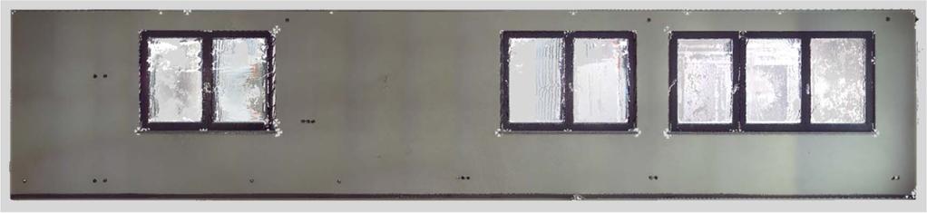
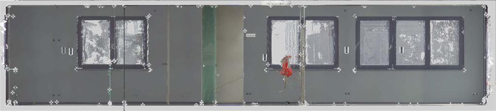
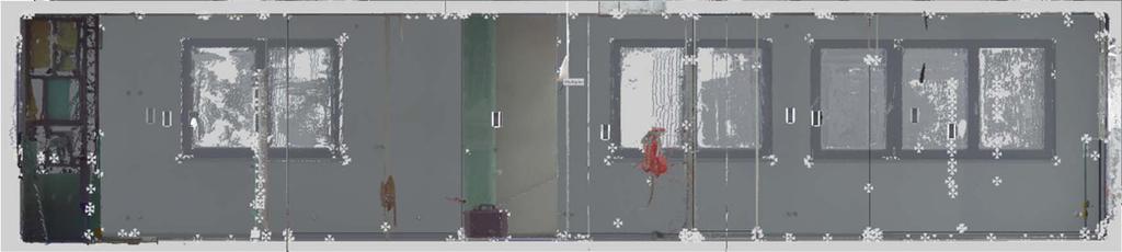
6 Improved Visualisation Colour Balancing SCENE 5.1.x SCENE 5.2 Left: 3D view without color balancing; Right: 3D view with color balancing applied during the creation of the project point cloud
7 Improved Visualisation Color Balancing Colour Balancing During the creation of the project point cloud, there is now the possibility to apply a colour balancing algorithm. Colour balancing tries to smooth the transition between overlapping scans which show different colour tints. This different colour tints typically result from slightly different lighting conditions at the different scan positions.


8 Improved Visualisation Super Sampling SCENE 5.1.x 3D View today SCENE 5.2 3D View with SuperSampling
9 Improved Visualisation Super Sampling Super Sampling Super Sampling is an option of SCENEs 3D View. When activated, SCENE is rendering the data for the 3D view in a higher resolution than your screen (2x, 3x or 4x higher) in the background. Before brought to display, this data is filtered and the resolution is adjusted to your screen size. In effect this will produce more crisp 3D view output which lets you see more details. Stray points and other artifacts are widely reduced.
10 Improved Visualisation Homogenisation for PointClouds Homogenisation for Point Clouds During the creation of scan point clouds or project point clouds, the new homogenization feature eliminates scan points which are closer than 1,5mm. While this does not result in a visual difference compared to not homogenised point clouds, this process reduces the file size by about 20% in average (depending on the specific scan data). This reduction in the number of scan points will also improve the efficiency of exporting scan data from 3D view and importing it into 3rd party software.
 SCENE 5.")

11 Improved Visualisation Auto Clustering SCENE 5.1.x (no auto clustering) SCENE 5.2 (with auto clustering) Left: Correspondence View of a set of scans after a failed registration without Auto Clustering; Right: Correspondence View of the same result with Auto Clustering activated
12 Improved Visualisation Auto Clustering Auto Clustering The Auto Clustering feature helps you to register scans which could not be done automatically by SCENE. Even if a set of scans cannot be placed together completely by SCENE, in many cases there will be groups of scans which already fit together. Once Auto Clustering is activated, SCENE will try to identify those groups of scans and sort them into separate scan clusters. Additionally those clusters will be moved away from each other. In the Correspondence View, those clusters are easily identifiable and allow you to arrange a smaller number of groups instead of a bigger number of single scans.

13 Multi Clipping Boxes Result of the multiple Clipping Box feature.
14 Multi Clipping Boxes Multi Clipping Boxes Once you have defined a Clipping Box in SCENE, the new command Create Clipping Boxes along an axis allows you to create copies of the initial Clipping Box. The dialog box of this command gives you the option to decide in which direction those copies should be created as well as how many copies should be made and the distance between the boxes. As a result, SCENE will create a folder, named as specified in the dialog box, which consists of the initial Clipping Box as well as of all copies. In 3D View, the folder will be shown as a bounding box around all Clipping Boxes. The whole set of boxes may be modified as well as the single Clipping Boxes.
15 Multi Orthophoto
16 Multi Orthophoto Multi Orthophoto The orthophoto tool allows you know to create orthophotos of a set of Clipping Boxes in one step. To do so, select a folder of Clipping Boxes instead of a single box. The new Multi Clipping Box feature for example is automatically creating such a folder for a set of parallel Clipping Boxes. Once you have selected a folder of Clipping Boxes, the orthophoto tool will use the resolution and scale settings to create one orthophoto per Clipping Box.
17 Performance Improvements Speed up of Feature Detection The algorithms for detection of natural features (corner points, planes, rectangles) have been improved. Fine Registration improved (now based on the full scans) Fine Registration in SCENE 5.2 is now using the full scans to optimize the tensions between the scans. Fast 3D Selections and Export (up to 50x faster than 5.1!) The performance of 3D selections and export of point cloud data from 3D View has been improved remarkably. Improved handling of surveyed references SCENE 5.2 is no more creating copies of the global References folder in the scan clusters. All surveyed references are stored in and retrieved from the global References folder. New measurement unit: US survey feet SCENE 5.2 is now offering US survey feet as additional unit for the display of dimension as well as for the export of point cloud data.
18 Upgrade to SCENE 5.2 Upgrade Path To upgrade from a previous version, customer needs to have an active SCENE maintenance contract
19
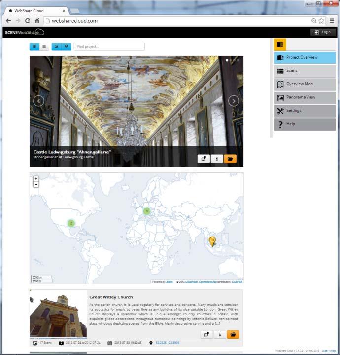
20 SCENE WebShare SCENE WebShare Cloud

21 Sharing and Collaboration

22

23 SCENE WebShare
24 SCENE WebShare SCENE WebShare is available at the FARO 3D App Center at no cost


25 3D App Center


26 SCENE WebShare 500+ downloads!


27

28 SCENE WebShare Cloud
29 What is SCENE WebShare Cloud? The SCENE WebShare Cloud is a secure cloud-based solution for storing and sharing scanning data with different project partners. Offering hosting service FARO eliminated the need to install software on your own computer. SCENE WebShare Cloud guarantees the utmost quality and security and can be used with mobile devices.
30 SCENE WebShare Cloud Features Minimal set up and maintenance effort Best possible security level Scalable infrastructure Hosting service Persistent measurements & annotations Support for mobile devices


31 The Points in the Cloud Project
32 SCENE WebShare Cloud Summary Easy sharing and viewing of scan projects Support for mobile devices Persistent measurements & annotations Hosted Cloud Service Security by encrypted communication & encrypted storage of project and user data Affordable, flexible payment plans

33 *SUBJECT TO REVISION*
Workshop. Dr. Denis Wohlfeld Innovation Manager P l a n t S i m u l a t i o n U s e r C o n f e r e n c e
 Workshop 3D Laser Scan PlantSimulation Dr. Denis Wohlfeld Innovation Manager 2 0 1 6 P l a n t S i m u l a t i o n U s e r C o n f e r e n c e GLOBAL FARO SITES W o r l d l e a d e r i n c o m p u t e
Fit for Purpose Visualisation Quality. Simon Horton Sales Engineer FARO UK 5 May,
 FARO SCENE Fit for Purpose Visualisation Quality Simon Horton Sales Engineer FARO UK 5 May, 2017 1 Visualisation Options FLS Data Scan Point Cloud Data (SPC) Project Point Cloud Data (PPC) Screen Shot
FILTER PACKAGE USER S GUIDE
 FILTER PACKAGE USER S GUIDE 1 CONTENT I. Introduction... 3 II. Installation... 3 III. Using the filters... 4 a- General... 4 b- Edge filter... 5 c- Uniform filter... 7 d- Angular filter... 8 e- Circle
Version 6.2 Release Notes October 2016
 Version 6.2 Release Notes October 2016 Copyright 2016 FARO. All rights reserved. No part of this publication may be reproduced or transmitted in any form or by any means without written permission of
Version 6.2 Release Notes February 2017
 Version 6.2 Release Notes February 2017 Copyright 2017 FARO. All rights reserved. No part of this publication may be reproduced or transmitted in any form or by any means without written permission of
Version 6.1 Release Notes September 2016
 Version 6.1 Release Notes September 2016 Copyright 2016 FARO. All rights reserved. No part of this publication may be reproduced or transmitted in any form or by any means without written permission of
Orientation and Manual registration USER S GUIDE
 Orientation and Manual registration USER S GUIDE 1 CONTENT I. Introduction... 3 II. Installation... 3 III. Using the plugin... 3 a- General... 3 b- Orientation... 3 c- Coordinates transformation... 4 d-
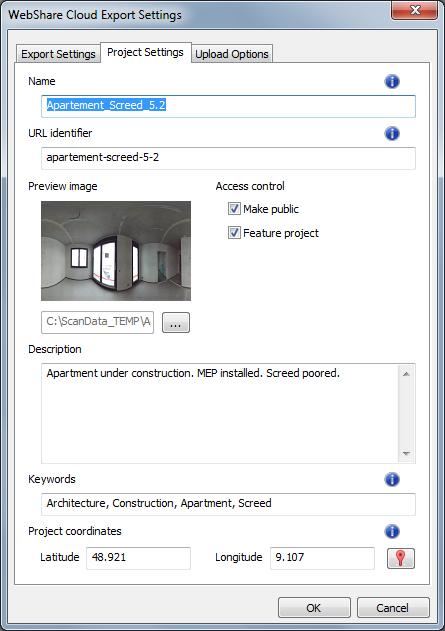
WebShare Cloud Basics
 3D Laser Scanning WebShare Cloud Basics WebShare Cloud Instructions The purpose of this document is to walk you through the process of using WebShare Cloud if you have been invited to view information.
OBJECT MANAGER PACKAGE USER S GUIDE
 OBJECT MANAGER PACKAGE USER S GUIDE 1 CONTENT I. Introduction... 3 II. Installation... 3 III. Using the plugins... 4 a- General... 4 b- Object properties manager... 4 c- Pipe manager... 6 d- Plane manager...
Overview of the Trimble TX5 Laser Scanner
 Overview of the Trimble TX5 Laser Scanner Trimble TX5 Revolutionary and versatile scanning solution Compact / Lightweight Efficient Economical Ease of Use Small and Compact Smallest and most compact 3D
Marc De Bruyne 3D Design Improvement Leader, DOW Chemical
 Marc De Bruyne 3D Design Improvement Leader, DOW Chemical John Foster Director, Profox Companies DOW Chemical Terneuzen in the Netherlands Globally, second largest DOW site after Freeport US. Producing
Terrestrial Laser Scanning assignment
 Terrestrial Laser Scanning assignment Objective: Underground 3D survey using terrestrial laser scanning Location: Otaniemi campus, Innopoli 3 Business Area Equipment: Faro Focus 3D Methodology: Multiple
3D Industrial plants. Documentation
 3D Industrial plants Documentation Published by: FARO Europe GmbH & Co. KG, Lingwiesenstrasse 11/2, D-70825 Korntal-Münchingen, Tel: +49 7150 9797-0, Fax: +49 7150 9797-44, info@faroeurope.com, www.faro.com
technical notes trimble realworks software
 technical notes trimble realworks software A POWERFUL 3D LASER SCANNING OFFICE SOFTWARE SUITE Designed for today s multifaceted scanning professional, Trimble RealWorks is a powerful office software that
RealWorks Software. A Powerful 3D Laser Scanning Office Software Suite
 TECHNICAL NOTES RealWorks Software A Powerful 3D Laser Scanning Office Software Suite Trimble RealWorks is a powerful office software that imports rich data from your 3D laser scanning instrument and transforms
Release Notes. Release Date: March, 2018
 Release Notes Release Date: March, 2018 Software: Geomagic Design X Version 2016.2.1 TABLE OF CONTENTS 1 INTRODUCTION 1 COPYRIGHT 1 2 INSTALLATION 2 SYSTEM REQUIREMENTS 2 DOWNLOAD AND INSTALL SOFTWARE
Trimble Realworks Software
 TECHNICAL NOTES Trimble Realworks Software A Powerful 3D Laser Scanning Office Software Suite DESIGNED FOR TODAY S MULTIFACETED SCANNING PROFESSIONAL, TRIMBLE REALWORKS IS A POWERFUL OFFICE SOFTWARE THAT
SiteAware Viewer. Quick Start Guide
 SiteAware Viewer Quick Start Guide Login Screen 1. Enter SiteAware provided username (an email address) and password 2. Click Login 3. Click Forgot Password to request a password reset 4. Sign Up option
Module 7 Defining Coordinate Systems
 Module 7 Defining Coordinate Systems Introduction Objectives Outline of Topics Covered The use of coordinate systems is very important in managing 3D spatial data including point clouds. In this module
Realworks Software. A Powerful 3D Laser Scanning Office Software Suite
 TECHNICAL NOTES Realworks Software A Powerful 3D Laser Scanning Office Software Suite Trimble RealWorks is a powerful office software that imports rich data from your 3D laser scanning instrument and transforms
Scan-to-BIM. NEWBIM ApS, Galina Slavova CEO, BIM Specialist
 Scan-to-BIM NEWBIM ApS, Galina Slavova CEO, BIM Specialist Agenda What is Building Information Modeling (BIM) About NEWBIM ApS 3D Laser Scanning Integration Case Study Demonstration Building Information
With FARO PointSense for Revit. Jörg Braunes Platform Owner Software Chris Palmer Sales Engineer 1
 From Point Clouds to BIM Models With FARO PointSense for Revit Jörg Braunes Platform Owner Software Chris Palmer Sales Engineer 1 Agenda Scan to BIM with Revit PointClouds in Revit Advanced Workflow with
Trimble RealWorks. What s new in version 9.0
 Trimble RealWorks What s new in version 9.0 Trimble RealWorks v9.0 What s new Over 40 new features and enhancements Navigation and visualization improvements SketchUp interoperability Additional 3 rd party
Product Release Summary AVEVA LFM Server
 Product Release Summary AVEVA LFM Server 5.0.0.5 Release Date: 18/03/2019 This document outlines all changes made in the above release of AVEVA LFM Server. Document Prepared by: Praveen Vankdoth Application
MODULE 10. OFFICESRUVEY : IMAGE MATCHING AND ORTHO PROJECTION
 MODULE 10. OFFICESRUVEY : IMAGE MATCHING AND ORTHO PROJECTION Learning Outcomes: Students should be able to match an imported images with the point cloud and create ortho-image from point clouds or meshes
Gexcel. JRC 3D Reconstructor BASIC MEASURING TOOLS
 Gexcel JRC 3D Reconstructor BASIC MEASURING TOOLS In this tutorial you will learn how to Save snapshots of the 3D view Measure distances and angles of the 3D models Add annotations to the objects in the
Making a custom foot model tutorial
 Making a custom foot model tutorial Goal: Making a customized 3D printable foot model. Pre-request: you should have downloaded 123D app on your smart phone, and download Meshmixer on your computer as well.
Reality Capture: From Point Cloud To Design To Visualisation. by Shuaib Yunos, Baker Baynes
 Reality Capture: From Point Cloud To Design To Visualisation by Shuaib Yunos, Baker Baynes Perspective: Design & Construction Designers are conceiving buildings differently. Building owners expect a lot
What s New In SA CHAPTER
 What s New In SA CHAPTER 1 One of the advantages of SpatialAnalyzer is that development occurs at a brisk pace. New feature requests, bug fixes, and changes are implemented quickly, giving you the opportunity
Simplicity is the new black: The BLK360 story
 Simplicity is the new black: The BLK360 story Vanda KADLECIKOVA Leica Geosystems Heerbrugg, Switzerland E-mail: vanda.kadlecikova@leica-geosystems.com Abstract Meet the game changer. The new Leica BLK360
Digitization of 3D Objects for Virtual Museum
 Digitization of 3D Objects for Virtual Museum Yi-Ping Hung 1, 2 and Chu-Song Chen 2 1 Department of Computer Science and Information Engineering National Taiwan University, Taipei, Taiwan 2 Institute of
BIM for infrastructure make easy with Laser Scanner. 17 October Beng Chieh Quah Head of Marketing Asia Pacific
 BIM for infrastructure make easy with Laser Scanner 17 October 2016 Beng Chieh Quah Head of Marketing Asia Pacific who is? founded in 1981 NASDAQ since 1997 Global technology company Offering a range of
CADZONE Application Workflow SCENE5.1 & CAD Zone: Capturing Data to Diagram Preparation
 CADZONE Application Workflow SCENE5.1 & CAD Zone: Capturing Data to Diagram Preparation Table of Contents Application Description...5 Required Materials...5 Focus 3D Setup...6 Plan the Scan...7 Target
Box Competitive Sheet January 2014
 This document is a comparison of file sharing and collaboration capabilities offered by Soonr Workplace and Box. Narrative is provided when there is no direct comparison between the capabilities or when
Page 1. Area-Subdivision Algorithms z-buffer Algorithm List Priority Algorithms BSP (Binary Space Partitioning Tree) Scan-line Algorithms
 Scan-line Algorithms") Visible Surface Determination Visibility Culling Area-Subdivision Algorithms z-buffer Algorithm List Priority Algorithms BSP (Binary Space Partitioning Tree) Scan-line Algorithms Divide-and-conquer strategy:
Visible Surface Determination Visibility Culling Area-Subdivision Algorithms z-buffer Algorithm List Priority Algorithms BSP (Binary Space Partitioning Tree) Scan-line Algorithms Divide-and-conquer strategy:
The Processing of Laser Scan Data for the Analysis of Historic Structures in Ireland
 The 7th International Symposium on Virtual Reality, Archaeology and Cultural Heritage VAST (2006) M. Ioannides, D. Arnold, F. Niccolucci, K. Mania (Editors) The Processing of Laser Scan Data for the Analysis
Perceptive Experience Content Apps
 Perceptive Experience Content Apps Technical Specifications Version: 2.4.x Written by: Product Knowledge, R&D Date: Thursday, August 2, 2018 2018 Hyland Software, Inc. and its affiliates. Table of Contents
Mosaic Tutorial: Advanced Workflow
 Mosaic Tutorial: Advanced Workflow This tutorial demonstrates how to mosaic two scenes with different color variations. You will learn how to: Reorder the display of the input scenes Achieve a consistent
Autodesk Navisworks Essentials Overview. Prerequisites. Course Outline
 Autodesk Navisworks Essentials Overview This course is designed for new users of Autodesk Navisworks users for the review, 4D simulation, and clash testing, and presenting of existing 3D geometry files.
Perfect PDF 9 Premium
 Perfect PDF 9 Premium The test results ( gut Good, sehr gut very good) refer to Perfect PDF & Print 8 and to versions 7, 6 and 5 of Perfect PDF Premium Professionally create, convert, edit and view PDF,
Z series Camera Calibration
 Z series Camera Calibration Calibration Field Place 30 5cm flat reflector targets 1 foot apart on three columns. Place 10 targets on each column vertically. The columns should be approximately 10 feet
TERRESTRIAL LASER SCANNER DATA PROCESSING
 TERRESTRIAL LASER SCANNER DATA PROCESSING L. Bornaz (*), F. Rinaudo (*) (*) Politecnico di Torino - Dipartimento di Georisorse e Territorio C.so Duca degli Abruzzi, 24 10129 Torino Tel. +39.011.564.7687
NATIONWIDE POINT CLOUDS AND 3D GEO- INFORMATION: CREATION AND MAINTENANCE GEORGE VOSSELMAN
 NATIONWIDE POINT CLOUDS AND 3D GEO- INFORMATION: CREATION AND MAINTENANCE GEORGE VOSSELMAN OVERVIEW National point clouds Airborne laser scanning in the Netherlands Quality control Developments in lidar
Principal Solutions Architect. Architecting in the Cloud
 Matt Tavis Principal Solutions Architect Architecting in the Cloud Cloud Best Practices Whitepaper Prescriptive guidance to Cloud Architects Just Search for Cloud Best Practices to find the link ttp://media.amazonwebservices.co
Linking with Active Plan suite of Products. Chris Palmer Sales Engineer April 28 th
 Webshare Cloud for Facilities Management Linking with Active Plan suite of Products Chris Palmer Sales Engineer April 28 th 2017 1 Contents What is Facilities Management? Managing a Built Asset Webshare
Model 3000 Series Bluetooth User s Manual. May 2017 Revision 2
 Model 3000 Series Bluetooth User s Manual May 2017 Revision 2 Model 3000 Series Bluetooth User s Manual Table of Contents Overview... 1 Model 3000 Series Guide... 1 Firmware... 1 Status LEDs... 2 User
Displayed with permission The American Surveyor April/May Copyright 2009 Cheves Media
 NASA s Environmental Simulation Chamber A at the Johnson Space Center in Houston will require upgrades to accommodate testing of components for the new space telescopes. Laser scanning with the FARO LS
Tutorial (Beginner level): Orthomosaic and DEM Generation with Agisoft PhotoScan Pro 1.3 (with Ground Control Points)
: Orthomosaic and DEM Generation with Agisoft PhotoScan Pro 1.3 (with Ground Control Points)") Tutorial (Beginner level): Orthomosaic and DEM Generation with Agisoft PhotoScan Pro 1.3 (with Ground Control Points) Overview Agisoft PhotoScan Professional allows to generate georeferenced dense point
Tutorial (Beginner level): Orthomosaic and DEM Generation with Agisoft PhotoScan Pro 1.3 (with Ground Control Points) Overview Agisoft PhotoScan Professional allows to generate georeferenced dense point
A Study of Angles & Curves
 A Study of Angles & Curves Method 1: Cutting Quilt Shapes/Using the Shapes Tools Open BERNINA CutWork Software. Make sure that Create New is selected. Click Next. Place a dot in front of New Graphic. Select
button in the lower-left corner of the panel if you have further questions throughout this tutorial.
 Mosaic Tutorial: Simple Workflow This tutorial demonstrates how to use the Seamless Mosaic tool to mosaic six overlapping digital aerial scenes. You will learn about displaying footprints and image data
ANSYS, Inc. February 8, ACT Extensions (Apps): Installation Procedure
: Installation Procedure") 1 2016 ANSYS, Inc. February 8, 2017 ACT Extensions (Apps): Installation Procedure Binary App Installation (1) Installing from the ACT Start Page: 1. From the Project page, select ACT Start Page. 2. Click
1 2016 ANSYS, Inc. February 8, 2017 ACT Extensions (Apps): Installation Procedure Binary App Installation (1) Installing from the ACT Start Page: 1. From the Project page, select ACT Start Page. 2. Click
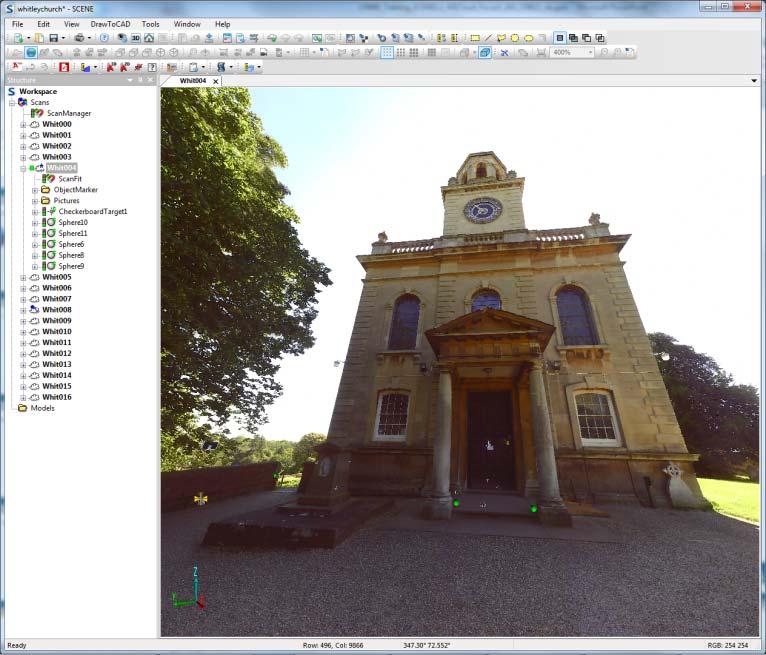
Registration with Spheres and Checker Board Targets
 Registration with Spheres and Checker Board Targets Work Shop Óscar García Uriarte Sales Engineer 1 Index When and Why Targets? Which kind of targets? How to place them. Targets in Scene. Accuracy using
OPEN. INTELLIGENT. Laser Scanning Software Solutions
 OPEN. INTELLIGENT. Laser Scanning Software Solutions www.lfm-software.com The Future of Laser Scanning Safe and efficient operation of complex engineering assets, and the efficient management of their
Licensing & Pricing FAQ
 Licensing & Pricing FAQ Table of Contents WINDOWS SERVER 2012 DATACENTER AND STANDARD EDITIONS... 4 Q1. What is new in Windows Server 2012?... 4 Q2. What is the difference between Windows Server 2012 Standard
Documentation And Collaborating With Developers
 7 Documentation And Collaborating With Developers Occasionally, when designs get developed, the end product may not look quite the same. This disconnect between product and design is not unusual as developers
Flowmap Generator Reference
 Flowmap Generator Reference Table of Contents Flowmap Overview... 3 What is a flowmap?... 3 Using a flowmap in a shader... 4 Performance... 4 Creating flowmaps by hand... 4 Creating flowmaps using Flowmap
GeoSLAM Hub The complete software solution for GeoSLAM data
 GeoSLAM Hub The complete software solution for GeoSLAM data GeoSLAM.com GeoSLAM Hub A comprehensive software suite that turns GeoSLAM data into actionable information and valuable deliverables. A part
SECURE DATA EXCHANGE
 POLICY-DRIVEN SOLUTIONS FOR SECURE DATA EXCHANGE Sending and receiving data is a fundamental part of daily business for nearly every organization. Companies need to share financial transaction details,
About Cisco Unified Communications Manager Group Setup
 Cisco Unified Communications Manager Group Setup This chapter provides information to configure a Cisco Unified Communications Manager group. About, on page 1 Cisco Unified Communications Manager Group
Apple OS Deployment Guide for the Enterprise
 Apple OS Deployment Guide for the Enterprise So your organization is about to deploy Mac, iphone, ipad and/or Apple TV to your users and you re not sure where to start? That s where the Apple management
GeoSLAM Software. The complete end-to-end solution for GeoSLAM data. GeoSLAM.com
 GeoSLAM Software The complete end-to-end solution for GeoSLAM data GeoSLAM.com GeoSLAM Software Solutions GeoSLAM Hub & Draw is a comprehensive software suite that transforms 3D point cloud data into actionable
Tutorial (Beginner level): Orthomosaic and DEM Generation with Agisoft PhotoScan Pro 1.3 (without Ground Control Points)
: Orthomosaic and DEM Generation with Agisoft PhotoScan Pro 1.3 (without Ground Control Points)") Tutorial (Beginner level): Orthomosaic and DEM Generation with Agisoft PhotoScan Pro 1.3 (without Ground Control Points) Overview Agisoft PhotoScan Professional allows to generate georeferenced dense point
Tutorial (Beginner level): Orthomosaic and DEM Generation with Agisoft PhotoScan Pro 1.3 (without Ground Control Points) Overview Agisoft PhotoScan Professional allows to generate georeferenced dense point
ScanSKU: Picking App User Guide- Google Drive
 ScanSKU: Picking App User Guide- Google Drive Step 1 Download the App Download the app at the download page here: www.scansku.com/downloads Install the app onto your Android Device and open it. For most
ECONOMICAL, STORAGE PURPOSE-BUILT FOR THE EMERGING DATA CENTERS. By George Crump
 ECONOMICAL, STORAGE PURPOSE-BUILT FOR THE EMERGING DATA CENTERS By George Crump Economical, Storage Purpose-Built for the Emerging Data Centers Most small, growing businesses start as a collection of laptops
LiDAR & Orthophoto Data Report
 LiDAR & Orthophoto Data Report Tofino Flood Plain Mapping Data collected and prepared for: District of Tofino, BC 121 3 rd Street Tofino, BC V0R 2Z0 Eagle Mapping Ltd. #201 2071 Kingsway Ave Port Coquitlam,
Milestone Systems. Quick guide: Register software license codes on Milestone Customer Dashboard. Milestone Customer Dashboard
 Milestone Systems Quick guide: Register software license codes on Milestone Customer Dashboard Milestone Customer Dashboard Introduction to this guide This quick guide introduces Milestone partners how
DocuWorks 8. Document handling software
 DocuWorks 8 Document handling software DocuWorks 8 At your desk, in the office, or outside Seamless support for business communication DocuWorks Mobile integrated application Document tray option Working
Project report Augmented reality with ARToolKit
 Project report Augmented reality with ARToolKit FMA175 Image Analysis, Project Mathematical Sciences, Lund Institute of Technology Supervisor: Petter Strandmark Fredrik Larsson (dt07fl2@student.lth.se)
Building a Fast Ray Tracer
 Abstract Ray tracing is often used in renderers, as it can create very high quality images at the expense of run time. It is useful because of its ability to solve many different problems in image rendering.
Selective Space Structures Manual
 Selective Space Structures Manual February 2017 CONTENTS 1 Contents 1 Overview and Concept 4 1.1 General Concept........................... 4 1.2 Modules................................ 6 2 The 3S Generator
Editing & Color Grading 101 in DaVinci Resolve 15
 Editing & Color Grading 101 in DaVinci Resolve 15 1. Exploring Resolve Exploring Resolve The Media Page The Edit Page The Fusion Page The Color Page The Fairlight Page The Deliver Page The Processing Pipeline
TECHNICAL DESCRIPTION
 TECHNICAL DESCRIPTION Product Snow Inventory Version 5 Release date 2016-09-27 Document date 2017-11-24 CONTENTS 1 Introduction... 3 1.1 What s new?... 3 2 Platform overview... 4 2.1 Architecture... 4
TERRESTRIAL AND NUMERICAL PHOTOGRAMMETRY 1. MID -TERM EXAM Question 4
 TERRESTRIAL AND NUMERICAL PHOTOGRAMMETRY 1. MID -TERM EXAM Question 4 23 November 2001 Two-camera stations are located at the ends of a base, which are 191.46m long, measured horizontally. Photographs
Cisco Container Platform
 Cisco Container Platform Pradnesh Patil Suhail Syed Cisco Spark How Questions? Use Cisco Spark to communicate with the speaker after the session 1. Find this session in the Cisco Live Mobile App 2. Click
Transitions and Photos
 4 Adding Lesson 3: Transitions and Photos You ve arranged your video clips in the order you want them. But the jump from one clip to the next is very abrupt, and you d like to smooth things out. You can
Smart Wireless WIFI Camera Instructions
 Smart Wireless WIFI Camera Instructions Dear users, Thanks for using this product. Please read the users' manual carefully and keep it for future reference. Thank you. 1 Content 1, How to download the
VE-Pro User Guide IES Virtual Environment 6.4
 -Pro User Guide IES Virtual Environment General Contents 1 Registration... 4 1.1 Activate Software... 5 1.1.1 Receive confirmation email...5 1.1.2 Click Activate software...5 1.1.3 Read and accept license
AXIS Store Reporter. Installation Guide
 Installation Guide Installation Guide Table of Contents System overview............................................ 3 AXIS Store Data Manager and AXIS Store Reporter.................. 4 How to log in to
OUTPUTS AND INTERFACES CARDIOSCAN HOLTER ECG. VERSION 76a
 OUTPUTS AND INTERFACES CARDIOSCAN HOLTER ECG VERSION 76a INTRODUCTION: CardioScan (10, 11, and 12) has evolved into a significant upgrade with the introduction of Version 76a. In addition to many new features
Object Storage Service. Product Introduction. Issue 04 Date HUAWEI TECHNOLOGIES CO., LTD.
 Issue 04 Date 2017-12-20 HUAWEI TECHNOLOGIES CO., LTD. 2017. All rights reserved. No part of this document may be reproduced or transmitted in any form or by any means without prior written consent of
9. Visible-Surface Detection Methods
 9. Visible-Surface Detection Methods More information about Modelling and Perspective Viewing: Before going to visible surface detection, we first review and discuss the followings: 1. Modelling Transformation:
Using Laser Scanning technology and software. Chris Palmer Sales Engineer 28 th April
 Construction Verification Using Laser Scanning technology and software Chris Palmer Sales Engineer 28 th April 2017 1 Contents What is construction verification? How do we measure and check construction
Introduction. Acute3D S.A.S. WTC Valbonne Sophia Antipolis. 120 route des Macarons.
 Introduction This benchmark compares the performances of the three main photo-based 3Dmodeling software. Five projects related to different kind of applications were led on the same machine and this document
Support for external aerotriangulation results from professional systems (Inpho, Bingo).
.") PhotoMesh v7.2 PhotoMesh v7.2 fully automates the generation of high-resolution, textured, 3D mesh models from standard 2D photographs, offering a significant reduction in cost and time compared to traditional
PhotoMesh v7.2 PhotoMesh v7.2 fully automates the generation of high-resolution, textured, 3D mesh models from standard 2D photographs, offering a significant reduction in cost and time compared to traditional
Reality Capture. Customer Case
 Reality Capture Customer Case Reality Capture customer case: MP-Map Oy Surveying company using FARO laser scanners MP-Map Oy is a construction surveying company with over 30 years of surveying experience
WIZBL WEB WALLET MANUAL
 WIZBL WEB WALLET MANUAL By WIZBL.CO.,LTD https://wallet.wizbl.io/ INDEX 1. Registration 1-1. Registration > Entering Verification Code 1-2. Completion of Registration (creation of Web Wallet) 2. Login
Rectangular Partitioning
 Rectangular Partitioning Joe Forsmann and Rock Hymas Introduction/Abstract We will look at a problem that I (Rock) had to solve in the course of my work. Given a set of non-overlapping rectangles each
Adobe Premiere Elements Tutorial
 Adobe Premiere Elements Tutorial Starting a New Project To import movie clips from a digital video camera, click on the Capture Video button. You will be prompted to name your project and choose a location
Graphics and Interaction Rendering pipeline & object modelling
 433-324 Graphics and Interaction Rendering pipeline & object modelling Department of Computer Science and Software Engineering The Lecture outline Introduction to Modelling Polygonal geometry The rendering
Quality Assurance and Quality Control Procedures for Survey-Grade Mobile Mapping Systems
 Quality Assurance and Quality Control Procedures for Survey-Grade Mobile Mapping Systems Latin America Geospatial Forum November, 2015 Agenda 1. Who is Teledyne Optech 2. The Lynx Mobile Mapper 3. Mobile
Autodesk Fusion 360 Training: The Future of Making Things Attendee Guide
 Autodesk Fusion 360 Training: The Future of Making Things Attendee Guide Abstract After completing this workshop, you will have a basic understanding of editing 3D models using Autodesk Fusion 360 TM to
The Trimble 3D Scanning Solution: Designed by Surveyors for Surveyors
 The Trimble 3D Scanning Solution: Designed by Surveyors for Surveyors TRIMBLE 3D SCANNING Designed by surveyors for surveyors, the Trimble 3D scanning solution follows the surveying workflow you re familiar
Anchor Competitive Sheet May 2015
 This document is a comparison of file sharing and collaboration capabilities offered by Soonr Workplace and Anchor. Narrative is provided when there is no direct comparison between the capabilities or
Render methods, Compositing, Post-process and NPR in NX Render
 Render methods, Compositing, Post-process and NPR in NX Render Overview What makes a good rendered image Render methods in NX Render Foregrounds and backgrounds Post-processing effects Compositing models
Getting Started. Extruding Features. Convert to feature class
 http://gmv.cast.uark.edu A Method Store for Advanced Survey and Modeling Technologies Mon, 01 Apr 2013 03:29:18 +0000 en-us hourly 1 http://wordpress.org/?v=3.5.1 http://gmv.cast.uark.edu/modeling/software-visualization/sketchup/workflow-sketchup/arcscene-tosketchup-to-arcscene/
Computer Graphics II
 Computer Graphics II Autumn 2017-2018 Outline Visible Surface Determination Methods (contd.) 1 Visible Surface Determination Methods (contd.) Outline Visible Surface Determination Methods (contd.) 1 Visible
Pharos Designer 2. Copyright Pharos Architectural Controls (15/1/2015)
") Pharos Designer 2 Welcome Welcome to Pharos Designer 2. We are delighted to introduce you to an entirely new version of the Pharos Designer software that picks up where the venerable and much- loved version
Pharos Designer 2 Welcome Welcome to Pharos Designer 2. We are delighted to introduce you to an entirely new version of the Pharos Designer software that picks up where the venerable and much- loved version
GRS Enterprise Synchronization Tool
 GRS Enterprise Synchronization Tool Last Revised: Thursday, April 05, 2018 Page i TABLE OF CONTENTS Anchor End User Guide... Error! Bookmark not defined. Last Revised: Monday, March 12, 2018... 1 Table
Comparison of Two Mathematical Models for the Surface Reconstruction for Deformation Analysis by Using FARO Focus 3D
 Ke-Wei Li Comparison of Two Mathematical Models for the Surface Reconstruction for Deformation Analysis by Using FARO Focus 3D Duration of the Thesis: 6 months Completion: October 2012 Tutor: Dipl.-Ing.
Terrain Modeling and Mapping for Telecom Network Installation Using Scanning Technology. Maziana Muhamad
 Terrain Modeling and Mapping for Telecom Network Installation Using Scanning Technology Maziana Muhamad Summarising LiDAR (Airborne Laser Scanning) LiDAR is a reliable survey technique, capable of: acquiring