Watershed Sciences 4930 & 6920 ADVANCED GIS
|
|
|
- Marion Elliott
- 6 years ago
- Views:
Transcription
1 Watershed Sciences 4930 & 6920 ADVANCED GIS TERRESTRIAL LASER SCANNING (AKA GROUND BASED LIDAR) Joe Wheaton

2 PURPOSE OF TODAY S DEMONSTRATION Introduce you to TLS Demystify TLS & LiDaR
3 TODAY S PLAN I. What is TLS? II. Let s see this thing in action III. What can be done with it? IV. Is this the future?


4 ACTIVE AND PASSIVE REMOTE SENSING
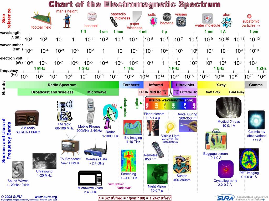
5
6 RECALL LIDAR Airborne-LiDaR


7 WHAT IS TLS? LiDaR from the ground Terrestrial Laser Scanner (a.k.a. ground-based LiDaR)


8 SORT OF LIKE A TOTAL STATION Normal total station needs a reflector target Reflectorless, just looks for a return off any surface TLS, like reflectorless on speed.

9 RECALL TOTAL STATION SURVEYING


10 FIRE THE SMART ONE Who s the smarter one? Who s on the dumb end of a stick now

11 A GUN AND A ROD Gun shoots and record Prism on rod reflects Technically an example of active remote sensing


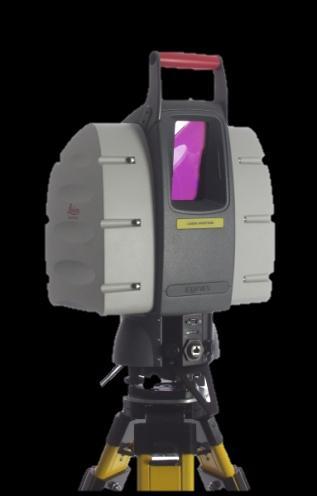
12 TS CALCULATES - DISTANCES Slope Distance is Calculated: Gun shoots beam Beam reflected back off prism Time is recorded Based on speed of light, slope distance is calculated
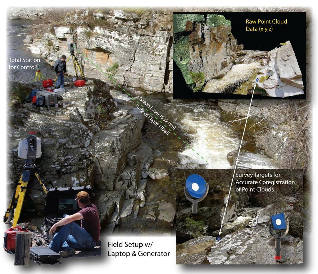
 They go on top of the")

 Allows:")
 non")
13 THE PRISM or REFLECTOR (WHAT IS SHOT) They go on top of the pole Standard unidirectional prism Fancy, 360 prism Multiple prisms (for long distances) Nothing (reflectorless) Allows: a) lower intensity laser, b) greater distances, c) non ambiguous returns
14 TS MEASURES - ANGLES Measures horizontal angles (azimuths or bearings) Measures vertical angles (zenith) Can only do this relative to a horizontal plane Horizontal plane exists because instrument is leveled
15 TOTAL STATION SURVEYING HORIZONTAL DEFINITIONS This diagram shows how you get your x & y coordinate values at each surveyed point

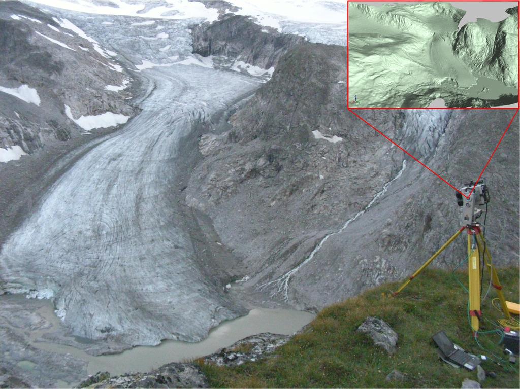
16 TOTAL STATION SURVEYING VERTICAL DEFINITIONS This diagram shows how you get the z coordinate R z of the point you want to survey

17 SO A TLS IS LIKE A REFLECTORLESS TOTAL STATION ON METH
18


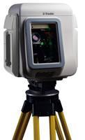
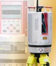
 Leica Shorter")


19 DIFFERENT INSTRUMENTS & SOFTWARE Different instruments help address different scales of questions (same technology) Leica Shorter range (up to 300 m) Higher Resolution & Accuracy (2-5 mm) Riegl Longer range (upto 2 or 8 km) Lower Resolution & Accuracy (10 mm)


20 LOTS OF OPTIONS OUT THERE Trimble GX Optech ILRIS-3D Leica ScanStation C10 Riegl VZ Leica HDS4400
21 TODAY S PLAN I. What is TLS? II. Let s see this thing in action III. What can be done with it? IV. Is this the future?
22 TODAY S PLAN I. What is TLS? II. Let s see this thing in action III. What can be done with it? IV. Is this the future?

23 RADIOHEAD HOUSE OF CARDS No cameras or lights used. Just a Terrestrial Laser Scanner
24 SOME APPLICATIONS ALREADY IN USE: Quantifying 3D-Structure of Wildlife habitat Mapping forests fuels for fire modeling Quantifying forest growth rates to estimate above ground carbon sequestration Calculating growth rates Mapping stratigraphy and structural geology Lichenometry Complex hydraulics in bedrock rivers Quantifying form drag & flow resistance from complex morphologies and vegetation Calculating surface roughness Morphological Sediment budgeting


25 TLS SCALE-FREE? High sampling rate enables landform recording at scales from the grain up to the reach in one single, integrated dataset Captures everything (three orders of magnitude more data) REACH-SCALE BAR-SCALE GRAIN-SCALE


26 Registered Feshie 2007 Scans > 250,000,000 xyz Photorendered Point cloud 12 scans registered Density (median) = ~1400pts/m2 > 250 coincident tie-points RMSE: Control = 7 mm Check = 8 mm
 See: Brasington, J., Vericat, D., Rychkov, I., 2012.")
27 DECIMATION Topographic Point Cloud Analysis Toolkit (ToPCAT; formerly PC-Tools) Look at statistical estimates of variance for elevation Absolute Zmin & Zmax Zmean range stdev - The aboslutle σ sk - Skew n - Count of number of points in cell (i.e. point density) See: Brasington, J., Vericat, D., Rychkov, I., Modeling river bed morphology, roughness, and surface sedimentology using high resolution terrestrial laser scanning. Water Resources Research 48. DOI: /2012wr


28 DETRENDED STD. DEV RELATES TO ROUGHNESS Simple empirical relationship to convert detrended σ to roughness


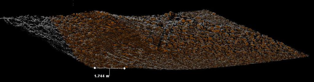
29 MAPPING PARTICLE GRAIN SIZES


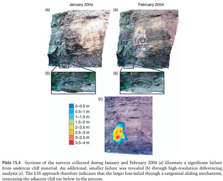
30 A SANDBAR EXAMPLE Roughness changes through time Use roughness as proxy for error Leary & Wheaton (2012)

31 WHAT IS GEOMORPHIC CHANGE DETECTION? Inferences about net geomorphic changes resulting from erosion & deposition that are detectable despite noise Inferences made with that repeat topography


32 ALTERNATIVES TO RASTER-BASED? With ALS, TLS, MBS, SFM point clouds becoming very common RASTER DEMs Raw Point Cloud


33 CloudCompare Free cloud visualization & analysis software 3D (not 2.5D) Triangular Meshing Very efficient Nice Visualization Available at:
. ISPRS journal of Photogrammmetry and Remote Sensing. Web site: http://www.")
34 M3C2C High Precision 3D point cloud comparison Nice command line utility No documentation just yet Paper is not out yet but: Lague, D., Brodu, N., Leroux, J., In Review. Accurate 3D comparison of complex topography with terrestrial laser scanner : application to the Rangitikei canyon (NZ). ISPRS journal of Photogrammmetry and Remote Sensing. Web site:
35 Image from Riegl:

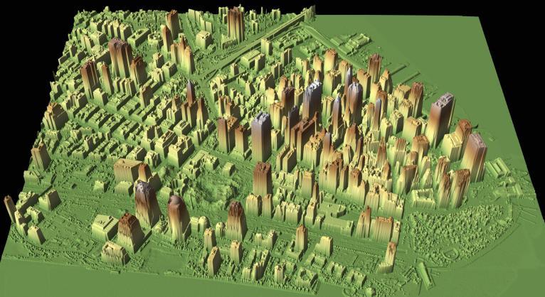
36 GLASGOW CITY MODEL Glasgow City Model:

37 CHARACTERIZING HYDRAULIC HABITAT From Large & Heritage (2007)


38 CHARACTERIZING VEGETATED ROUGHNESS Relate projected area (frontal area drag) from TLS to Airborne LiDaR Map roughness spatially over much larger areas From Manners et al. (2013) - JGR


39 A CHALLENGE

40 ONE SMALL PROBLEM NearIR LiDaR does not penetrate the water surface

41 WATER SURFACE TOPOGRAPHY

42 COASTAL CLIFF EROSION

43 TRACKING INDIVIDUAL FAILURE EVENTS
44


45 OTHER APPLICATIONS Architectural Pipe-networks Animation industry Crime-scene/ accident inventory Archeology Heritage Scanning Civil Infrastructure Application Photos from Land-scope:
46 TODAY S PLAN I. What is TLS? II. Let s see this thing in action III. What can be done with it? IV. Is this the future?
47 FUNDAMENTAL CHANGE IN PROBLEM From an era of being fundamentally data poor to being data rich Too much data can be just as bad as the real world
48 TODAY S PLAN I. What is TLS? II. Let s see this thing in action III. What can be done with it? IV. Is this the future?
49 SOME WEBSITES Groups: ISPRS: /wgtc_5.aspx Laser Scanning Forum: Projects: Rees Scan: Manufacturers Leica: Riegl: Trimble: ml Optech: Guang Zheng s Forestry Research: 20inventory%20characterization%20from%2 0GBL.htm


50 GOOD BOOK ON TLS Laser Scanning for the Environmental Sciences Most of text online:
51
N.J.P.L.S. An Introduction to LiDAR Concepts and Applications
 N.J.P.L.S. An Introduction to LiDAR Concepts and Applications Presentation Outline LIDAR Data Capture Advantages of Lidar Technology Basics Intensity and Multiple Returns Lidar Accuracy Airborne Laser
An Introduction to Lidar & Forestry May 2013
 An Introduction to Lidar & Forestry May 2013 Introduction to Lidar & Forestry Lidar technology Derivatives from point clouds Applied to forestry Publish & Share Futures Lidar Light Detection And Ranging
Airborne Laser Scanning: Remote Sensing with LiDAR
 Airborne Laser Scanning: Remote Sensing with LiDAR ALS / LIDAR OUTLINE Laser remote sensing background Basic components of an ALS/LIDAR system Two distinct families of ALS systems Waveform Discrete Return
GEOMORPHIC CHANGE DETECTION
 GEOMORPHIC CHANGE DETECTION I. THRESHOLDING ALTERNATIVES IN GCD April 30 th to May 1 st, 2014 Sponsored by: WORKSHOP PLAN DAY 1 (AFTERNOON) E. Essential Best Practices to Support GCD F. Traditional Approaches
Terrestrial Laser Scanning: Applications in Civil Engineering Pauline Miller
 Terrestrial Laser Scanning: Applications in Civil Engineering Pauline Miller School of Civil Engineering & Geosciences Newcastle University Overview Laser scanning overview Research applications geometric
Ground LiDAR fuel measurements of the Prescribed Fire Combustion and Atmospheric Dynamics Research Experiment
 Ground LiDAR fuel measurements of the Prescribed Fire Combustion and Atmospheric Dynamics Research Experiment Eric Rowell, Erik Apland and Carl Seielstad IAWF 4 th Fire Behavior and Fuels Conference, Raleigh,
Advanced Highway Maintenance and Construction Technology Research Center
 Advanced Highway Maintenance and Construction Technology Research Center Department of Mechanical and Aerospace Engineering University of California at Davis Creating Standards and Specifications for the
SPAR, ELMF 2013, Amsterdam. Laser Scanning on the UK Highways Agency Network. Hamish Grierson Blom Uk
 SPAR, ELMF 2013, Amsterdam Laser Scanning on the UK Highways Agency Network Hamish Grierson Blom Uk www.blomasa.com www.blom-uk.co.uk Blom UK Part of the Blom Group Blom Group - Europe s largest aerial
TLS Parameters, Workflows and Field Methods
 TLS Parameters, Workflows and Field Methods Marianne Okal, UNAVCO June 20 th, 2014 How a Lidar instrument works (Recap) Transmits laser signals and measures the reflected light to create 3D point clouds.
Terrain Modeling and Mapping for Telecom Network Installation Using Scanning Technology. Maziana Muhamad
 Terrain Modeling and Mapping for Telecom Network Installation Using Scanning Technology Maziana Muhamad Summarising LiDAR (Airborne Laser Scanning) LiDAR is a reliable survey technique, capable of: acquiring
HEURISTIC FILTERING AND 3D FEATURE EXTRACTION FROM LIDAR DATA
 HEURISTIC FILTERING AND 3D FEATURE EXTRACTION FROM LIDAR DATA Abdullatif Alharthy, James Bethel School of Civil Engineering, Purdue University, 1284 Civil Engineering Building, West Lafayette, IN 47907
THE USE OF TERRESTRIAL LASER SCANNING FOR MEASUREMENTS IN SHALLOW-WATER: CORRECTION OF THE 3D COORDINATES OF THE POINT CLOUD
 Photogrammetry and Remote Sensing Published as: Deruyter, G., Vanhaelst, M., Stal, C., Glas, H., De Wulf, A. (2015). The use of terrestrial laser scanning for measurements in shallow-water: correction
LiForest Software White paper. TRGS, 3070 M St., Merced, 93610, Phone , LiForest
 0 LiForest LiForest is a platform to manipulate large LiDAR point clouds and extract useful information specifically for forest applications. It integrates a variety of advanced LiDAR processing algorithms
CloudCompare CICESE Workshop 2015
 CloudCompare CICESE Workshop 2015 Daniel Girardeau-Montaut daniel.girardeau@gmail.com Workshop Interactive! Copy the sample files from the USB thumb drive: You can install CloudCompare 2.6.1 with the Windows
TLS Parameters, Workflows and Field Methods
 TLS Parameters, Workflows and Field Methods Marianne Okal, UNAVCO GSA, October 20 th, 2017 How a Lidar instrument works (Recap) Transmits laser signals and measures the reflected light to create 3D point
2D MODELING. Overview of 2D Modeling
 Overview of 2D Modeling No one believes a model, except the person who wrote it; Everyone believes data, except the person who collected it. unknown wise scientist Two dimensional (depth averaged) hydrodynamic
TLS Parameters, Workflows and Field Methods
 TLS Parameters, Workflows and Field Methods Marianne Okal, UNAVCO GSA, September 23 rd, 2016 How a Lidar instrument works (Recap) Transmits laser signals and measures the reflected light to create 3D point
Light Detection and Ranging (LiDAR)
") Light Detection and Ranging (LiDAR) http://code.google.com/creative/radiohead/ Types of aerial sensors passive active 1 Active sensors for mapping terrain Radar transmits microwaves in pulses determines
Light Detection and Ranging (LiDAR) http://code.google.com/creative/radiohead/ Types of aerial sensors passive active 1 Active sensors for mapping terrain Radar transmits microwaves in pulses determines
LIDAR and Terrain Models: In 3D!
 LIDAR and Terrain Models: In 3D! Stuart.green@teagasc.ie http://www.esri.com/library/whitepapers/pdfs/lidar-analysis-forestry.pdf http://www.csc.noaa.gov/digitalcoast/_/pdf/refinement_of_topographic_lidar_to_create_a_bare_e
Terrestrial GPS setup Fundamentals of Airborne LiDAR Systems, Collection and Calibration. JAMIE YOUNG Senior Manager LiDAR Solutions
 Terrestrial GPS setup Fundamentals of Airborne LiDAR Systems, Collection and Calibration JAMIE YOUNG Senior Manager LiDAR Solutions Topics Terrestrial GPS reference Planning and Collection Considerations
Airborne LiDAR Data Acquisition for Forestry Applications. Mischa Hey WSI (Corvallis, OR)
") Airborne LiDAR Data Acquisition for Forestry Applications Mischa Hey WSI (Corvallis, OR) WSI Services Corvallis, OR Airborne Mapping: Light Detection and Ranging (LiDAR) Thermal Infrared Imagery 4-Band
Airborne LiDAR Data Acquisition for Forestry Applications Mischa Hey WSI (Corvallis, OR) WSI Services Corvallis, OR Airborne Mapping: Light Detection and Ranging (LiDAR) Thermal Infrared Imagery 4-Band
Overview. 1. Aerial LiDAR in Wisconsin (20 minutes) 2. Demonstration of data in CAD (30 minutes) 3. High Density LiDAR (20 minutes)
 2. Demonstration of data in CAD (30 minutes) 3. High Density LiDAR (20 minutes)") Overview 1. Aerial LiDAR in Wisconsin (20 minutes) 2. Demonstration of data in CAD (30 minutes) 3. High Density LiDAR (20 minutes) 4. Aerial lidar technology advancements (15 minutes) 5. Q & A 1. Aerial
Overview 1. Aerial LiDAR in Wisconsin (20 minutes) 2. Demonstration of data in CAD (30 minutes) 3. High Density LiDAR (20 minutes) 4. Aerial lidar technology advancements (15 minutes) 5. Q & A 1. Aerial
Integrating the Generations, FIG Working Week 2008,Stockholm, Sweden June 2008
 H. Murat Yilmaz, Aksaray University,Turkey Omer Mutluoglu, Selçuk University, Turkey Murat Yakar, Selçuk University,Turkey Cutting and filling volume calculation are important issues in many engineering
QUALITY CONTROL METHOD FOR FILTERING IN AERIAL LIDAR SURVEY
 QUALITY CONTROL METHOD FOR FILTERING IN AERIAL LIDAR SURVEY Y. Yokoo a, *, T. Ooishi a, a Kokusai Kogyo CO., LTD.,Base Information Group, 2-24-1 Harumicho Fuchu-shi, Tokyo, 183-0057, JAPAN - (yasuhiro_yokoo,
2/19/2018. Who are we? Who am I? What is Scanning? How does scanning work? How does scanning work? Scanning for Today s Surveyors
 2/19/2018 Who are we? Scanning for Today s Surveyors Survey, GIS, and Construction dealer Founded in 1988 Employee Owned Headquartered in Bismarck, ND States covered: ND, SD, MN, MT, WY, CO, UT, ID, WA,
Landslides Detection and Monitoring along Dieppe Coastal Cliffs Ability of boat-based Mobile Laser Scanning
 Vertical Geology Conference 2014, University of Lausanne Landslides Detection and Monitoring along Dieppe Coastal Cliffs Ability of boat-based Mobile Laser Scanning Clément Michoud 1, Dario Carrea 1, S.
Geospatial Engineering Problems & Solutions Associated With NDP Roads, Tunnelling & Civil Engineering Projects Use of HDS Leica Laser Scanners
 Geospatial Engineering Problems & Solutions Associated With NDP Roads, Tunnelling & Civil Engineering Projects Use of HDS Leica Laser Scanners Laser Scanning Laser Scanning is a method of collecting large
Lidar Technical Report
 Lidar Technical Report Oregon Department of Forestry Sites Presented to: Oregon Department of Forestry 2600 State Street, Building E Salem, OR 97310 Submitted by: 3410 West 11st Ave. Eugene, OR 97402 April
LiDAR Remote Sensing Data Collection: Yaquina and Elk Creek Watershed, Leaf-On Acquisition
 LiDAR Remote Sensing Data Collection: Yaquina and Elk Creek Watershed, Leaf-On Acquisition Submitted by: 4605 NE Fremont, Suite 211 Portland, Oregon 97213 April, 2006 Table of Contents LIGHT DETECTION
EXTRACTING SURFACE FEATURES OF THE NUECES RIVER DELTA USING LIDAR POINTS INTRODUCTION
 EXTRACTING SURFACE FEATURES OF THE NUECES RIVER DELTA USING LIDAR POINTS Lihong Su, Post-Doctoral Research Associate James Gibeaut, Associate Research Professor Harte Research Institute for Gulf of Mexico
High Resolution Laserscanning, not only for 3D-City Models
 Lohr 133 High Resolution Laserscanning, not only for 3D-City Models UWE LOHR, Ravensburg ABSTRACT The TopoSys laserscanner system is designed to produce digital elevation models (DEMs) of the environment
Survey to Support 2D Hydraulic Aquatic Habitat Models
 Survey to Support 2D Hydraulic Aquatic Habitat Models New Mexico Interstate Stream Commission (NMISC) Presented at the 2015 Esri International User Conference San Diego Convention Center Wednesday, July
CLASSIFICATION OF NONPHOTOGRAPHIC REMOTE SENSORS
 CLASSIFICATION OF NONPHOTOGRAPHIC REMOTE SENSORS PASSIVE ACTIVE DIGITAL CAMERA THERMAL (e.g. TIMS) VIDEO CAMERA MULTI- SPECTRAL SCANNERS VISIBLE & NIR MICROWAVE HYPERSPECTRAL (e.g. AVIRIS) SLAR Real Aperture
UAS based laser scanning for forest inventory and precision farming
 UAS based laser scanning for forest inventory and precision farming M. Pfennigbauer, U. Riegl, P. Rieger, P. Amon RIEGL Laser Measurement Systems GmbH, 3580 Horn, Austria Email: mpfennigbauer@riegl.com,
A 4D Filtering and Calibration Technique for Small-Scale Point Cloud Change Detection with a Terrestrial Laser Scanner
 Remote Sens. 2015, 7, 13029-13052; doi:10.3390/rs71013029 Article OPEN ACCESS remote sensing ISSN 2072-4292 www.mdpi.com/journal/remotesensing A 4D Filtering and Calibration Technique for Small-Scale Point
2/9/2016. Session Agenda: Implementing new Geospatial Technologies for more efficient data capture
 Implementing new Geospatial Technologies for more efficient data capture Jay Haskamp Applied Geospatial Engineer Steve Richter VP Sales Session Agenda: Today s changing technologies and what lies ahead
TLS DEFORMATION MEASUREMENT USING LS3D SURFACE AND CURVE MATCHING
 TLS DEFORMATION MEASUREMENT USING LS3D SURFACE AND CURVE MATCHING O. Monserrat, M. Crosetto, B. Pucci Institute of Geomatics, Castelldefels, Barcelona, Spain, (oriol.monserrat, michele.crosetto, barbara.pucci)@ideg.es
Improvement of the Edge-based Morphological (EM) method for lidar data filtering
 method for lidar data filtering") International Journal of Remote Sensing Vol. 30, No. 4, 20 February 2009, 1069 1074 Letter Improvement of the Edge-based Morphological (EM) method for lidar data filtering QI CHEN* Department of Geography,
International Journal of Remote Sensing Vol. 30, No. 4, 20 February 2009, 1069 1074 Letter Improvement of the Edge-based Morphological (EM) method for lidar data filtering QI CHEN* Department of Geography,
NERC GEOPHYSICAL EQUIPMENT FACILTY LOAN REPORT: 892. Hyperscale Modelling of Braided Rivers: linking morphology, sedimentology and sediment transport
 NERC GEOPHYSICAL EQUIPMENT FACILTY LOAN REPORT: 892 Hyperscale Modelling of Braided Rivers: linking morphology, sedimentology and sediment transport James Brasington School of Geography, Queen Mary, University
Learning Objectives LIGHT DETECTION AND RANGING. Sensing. Blacksburg, VA July 24 th 30 th, 2010 LiDAR: Mapping the world in 3-D Page 1
 LiDAR: Mapping the world in 3-D Val Thomas Department of Forest Resources & Environmental Conservation July 29, 2010 Learning Objectives Part 1: Lidar theory What is lidar? How does lidar work? What are
Boresight alignment method for mobile laser scanning systems
 Boresight alignment method for mobile laser scanning systems P. Rieger, N. Studnicka, M. Pfennigbauer RIEGL Laser Measurement Systems GmbH A-3580 Horn, Austria Contents A new principle of boresight alignment
This is a cartoon of the standard NIR lidar. Only get 5 partial returns from each laser shot. In effect we re wasting much of the laser
 1 This is a cartoon of the standard NIR lidar. Only get 5 partial returns from each laser shot. In effect we re wasting much of the laser energy\project costs, because we never record much of the energy
Rogue River LIDAR Project, 2012 Delivery 1 QC Analysis LIDAR QC Report September 6 th, 2012
 O R E G O N D E P A R T M E N T O F G E O L O G Y A N D M I N E R A L I N D U S T R I E S OLC Rogue River Delivery 1 Acceptance Report. Department of Geology & Mineral Industries 800 NE Oregon St, Suite
An Accuracy Assessment of Derived Digital Elevation Models from Terrestrial Laser Scanning in a Sub-Tropical Forested Environment
 Article An Accuracy Assessment of Derived Digital Elevation Models from Terrestrial Laser Scanning in a Sub-Tropical Forested Environment Jasmine Muir 1,2,3, * ID, Nicholas Goodwin 1,2, John Armston 1,2,4
Contents of Lecture. Surface (Terrain) Data Models. Terrain Surface Representation. Sampling in Surface Model DEM
 Data Models. Terrain Surface Representation. Sampling in Surface Model DEM") Lecture 13: Advanced Data Models: Terrain mapping and Analysis Contents of Lecture Surface Data Models DEM GRID Model TIN Model Visibility Analysis Geography 373 Spring, 2006 Changjoo Kim 11/29/2006 1
Lecture 13: Advanced Data Models: Terrain mapping and Analysis Contents of Lecture Surface Data Models DEM GRID Model TIN Model Visibility Analysis Geography 373 Spring, 2006 Changjoo Kim 11/29/2006 1
A 3D Scanner Based Technology for Land Levelling
 A 3D Scanner Based Technology for Land Levelling Kunal Chakraborti, Rupam Ghosh Student, Dept of Civil Engineering, Modern Institute of Engineering & Technology, Bandel, Hooghly, West Bengal, India ABSTRACT:
LiDAR and its use for the enhanced forest inventory
 LiDAR and its use for the enhanced forest inventory Richard Fournier Département de géomatique appliquée Workshop of the Canadian Institute of Forestry Corner Brook, Newfoundland, March 27 2013 LiDAR -
TERRESTRIAL LASER SCANNER DATA PROCESSING
 TERRESTRIAL LASER SCANNER DATA PROCESSING L. Bornaz (*), F. Rinaudo (*) (*) Politecnico di Torino - Dipartimento di Georisorse e Territorio C.so Duca degli Abruzzi, 24 10129 Torino Tel. +39.011.564.7687
Terrestrial radar and laser scanning for deformation monitoring: first steps towards assisted radar scanning
 Terrestrial radar and laser scanning for deformation monitoring: first steps towards assisted radar scanning Daniel Wujanz 1, Frank Neitzel 1, H.P. Hebel 2, J. Linke 2, W. Busch 2 1 Chair of Geodesy and
A Method to Create a Single Photon LiDAR based Hydro-flattened DEM
 A Method to Create a Single Photon LiDAR based Hydro-flattened DEM Sagar Deshpande 1 and Alper Yilmaz 2 1 Surveying Engineering, Ferris State University 2 Department of Civil, Environmental, and Geodetic
LIDAR MAPPING FACT SHEET
 1. LIDAR THEORY What is lidar? Lidar is an acronym for light detection and ranging. In the mapping industry, this term is used to describe an airborne laser profiling system that produces location and
LORI COLLINS, RESEARCH ASSOCIATE PROFESSOR CONTRIBUTIONS BY: RICHARD MCKENZIE AND GARRETT SPEED, DHHC USF L IBRARIES
 LORI COLLINS, RESEARCH ASSOCIATE PROFESSOR CONTRIBUTIONS BY: RICHARD MCKENZIE AND GARRETT SPEED, DHHC USF L IBRARIES AERIAL AND TERRESTRIAL SURVEY WORKFLOWS Workflow from project planning applications
Mobile LiDAR in Road Surface Quality Control and Renovation - Latest Development of Terrasolid Software
 Geodesy, Mine Survey and Aerial Topography. At the turn of the centuries. Moscow 14 15 February 2013 Mobile LiDAR in Road Surface Quality Control and Renovation - Latest Development of Terrasolid Software
Central Coast LIDAR Project, 2011 Delivery 1 QC Analysis LIDAR QC Report February 17 th, 2012
 O R E G O N D E P A R T M E N T O F G E O L O G Y A N D M I N E R A L I N D U S T R I E S OLC Central Coast Delivery 1 Acceptance Report. Department of Geology & Mineral Industries 800 NE Oregon St, Suite
LiDAR Applications in Surveying and Engineering
 LiDAR Applications in Surveying and Engineering 2013 NC GIS Conference Raleigh, NC Frank A. Alex Rankin, III PE, PLS What is LiDAR? Light Detection and Ranging Analogous to RADAR, but using a different
Lidar Sensors, Today & Tomorrow. Christian Sevcik RIEGL Laser Measurement Systems
 Lidar Sensors, Today & Tomorrow Christian Sevcik RIEGL Laser Measurement Systems o o o o Online Waveform technology Stand alone operation no field computer required Remote control through wireless network
The Use of UAV s for Gathering Spatial Information. James Van Rens CEO MAPPS Winter Conference January, 2015
 The Use of UAV s for Gathering Spatial Information James Van Rens CEO MAPPS Winter Conference January, 2015 1 UAV Technological Timeline 1980 s RPV (Remotely Piloted Vehicle) Operator on ground, almost
Surveying Revolutionized. LaserScanning. >> By Marc Cheves, LS
 LaserScanning Riegl Z360 scanner at tunnel entrance to Saguaro Ranch Scan of tunnel entrance Surveying Revolutionized urveyor Richard Darling s company purchased their first scanner, a Riegl Z360, in 2002
Digital Elevation Models
 Digital Elevation Models National Elevation Dataset 1 Data Sets US DEM series 7.5, 30, 1 o for conterminous US 7.5, 15 for Alaska US National Elevation Data (NED) GTOPO30 Global Land One-kilometer Base
Snow cover change detection with laser scanning range and brightness measurements
 Snow cover change detection with laser scanning range and brightness measurements Sanna Kaasalainen, Harri Kaartinen, Antero Kukko, Henri Niittymäki Department of Remote Sensing and Photogrammetry 5th
Quality Assurance and Quality Control Procedures for Survey-Grade Mobile Mapping Systems
 Quality Assurance and Quality Control Procedures for Survey-Grade Mobile Mapping Systems Latin America Geospatial Forum November, 2015 Agenda 1. Who is Teledyne Optech 2. The Lynx Mobile Mapper 3. Mobile
VALIDATION OF A NEW 30 METER GROUND SAMPLED GLOBAL DEM USING ICESAT LIDARA ELEVATION REFERENCE DATA
 VALIDATION OF A NEW 30 METER GROUND SAMPLED GLOBAL DEM USING ICESAT LIDARA ELEVATION REFERENCE DATA M. Lorraine Tighe Director, Geospatial Solutions Intermap Session: Photogrammetry & Image Processing
Assimilation of Break line and LiDAR Data within ESRI s Terrain Data Structure (TDS) for creating a Multi-Resolution Terrain Model
 for creating a Multi-Resolution Terrain Model") Assimilation of Break line and LiDAR Data within ESRI s Terrain Data Structure (TDS) for creating a Multi-Resolution Terrain Model Tarig A. Ali Department of Civil Engineering American University of Sharjah,
Assimilation of Break line and LiDAR Data within ESRI s Terrain Data Structure (TDS) for creating a Multi-Resolution Terrain Model Tarig A. Ali Department of Civil Engineering American University of Sharjah,
FOR 274: Surfaces from Lidar. Lidar DEMs: Understanding the Returns. Lidar DEMs: Understanding the Returns
 FOR 274: Surfaces from Lidar LiDAR for DEMs The Main Principal Common Methods Limitations Readings: See Website Lidar DEMs: Understanding the Returns The laser pulse travel can travel through trees before
UAV Surveying II. Precision. Accuracy. Reliability
 UAV Surveying II Precision. Accuracy. Reliability Part One: Project Lifecycle Deliverables Part Two: Evaluation of UAV Data Accuracy and Examples of Error Part Three: AGENDA Review of Results Examples
Jeffrey A. Schepers P.S. EIT Geospatial Services Holland Engineering Inc. 220 Hoover Blvd, Suite 2, Holland, MI Desk
 Jeffrey A. Schepers P.S. EIT Geospatial Services Holland Engineering Inc. 220 Hoover Blvd, Suite 2, Holland, MI 49423 616-594-5127 Desk 616-322-1724 Cell 616-392-5938 Office Mobile LiDAR - Laser Scanning
Aerial and Mobile LiDAR Data Fusion
 Creating Value Delivering Solutions Aerial and Mobile LiDAR Data Fusion Dr. Srini Dharmapuri, CP, PMP What You Will Learn About LiDAR Fusion Mobile and Aerial LiDAR Technology Components & Parameters Project
Airborne discrete return LiDAR data was collected on September 3-4, 2007 by
 SUPPLEMENTAL MATERIAL 2 LiDAR Specifications Airborne discrete return LiDAR data was collected on September 3-4, 2007 by Watershed Sciences, Inc. (Corvallis, Oregon USA). LiDAR was collected approximately
Wednesday, July 15, Author: Eldris Ferrer Gonzalez, M.Sc. Engineering CSA Group
 Twenty ninth Annual ESRI International User Conference Wednesday, July 15, 2009 Author: Eldris Ferrer Gonzalez, M.Sc. Engineering CSA Group Introduction to Valenciano Project LIDAR Survey for Valenciano
Third Rock from the Sun
 Geodesy 101 AHD LiDAR Best Practice The Mystery of LiDAR Best Practice Glenn Jones SSSi GIS in the Coastal Environment Batemans Bay November 9, 2010 Light Detection and Ranging (LiDAR) Basic principles
Automated Extraction of Buildings from Aerial LiDAR Point Cloud and Digital Imaging Datasets for 3D Cadastre - Preliminary Results
 Automated Extraction of Buildings from Aerial LiDAR Point Cloud and Digital Imaging Datasets for 3D Pankaj Kumar 1*, Alias Abdul Rahman 1 and Gurcan Buyuksalih 2 ¹Department of Geoinformation Universiti
3D SPATIAL DATA ACQUISITION AND MODELING OF ANGHEL SALIGNY MONUMENT USING TERRESTRIAL LASER SCANNING
 JOURNAL OF APPLIED ENGINEERING SCIENCES VOL. 2(15), issue 2_2012 ISSN 2247-3769 ISSN-L 2247-3769 (Print) / e-issn:2284-7197 3D SPATIAL DATA ACQUISITION AND MODELING OF ANGHEL SALIGNY MONUMENT USING TERRESTRIAL
NEXTMap World 10 Digital Elevation Model
 NEXTMap Digital Elevation Model Intermap Technologies, Inc. 8310 South Valley Highway, Suite 400 Englewood, CO 80112 10012015 NEXTMap (top) provides an improvement in vertical accuracy and brings out greater
Intensity Augmented ICP for Registration of Laser Scanner Point Clouds
 Intensity Augmented ICP for Registration of Laser Scanner Point Clouds Bharat Lohani* and Sandeep Sashidharan *Department of Civil Engineering, IIT Kanpur Email: blohani@iitk.ac.in. Abstract While using
Bentley Descartes and what s new in Descartes V8i (SELECTseries 3) What is Bentley Descartes? 2011 Bentley Systems, Incorporated
 What is Bentley Descartes? 2011 Bentley Systems, Incorporated") Bentley Descartes and what s new in Descartes V8i (SELECTseries 3) Tom Stogdill Bentley Systems, Inc. What is Bentley Descartes? Image Processing Raster Geo-Referencing Advanced raster transformation (warping,
Bentley Descartes and what s new in Descartes V8i (SELECTseries 3) Tom Stogdill Bentley Systems, Inc. What is Bentley Descartes? Image Processing Raster Geo-Referencing Advanced raster transformation (warping,
A Procedure for accuracy Investigation of Terrestrial Laser Scanners
 A Procedure for accuracy Investigation of Terrestrial Laser Scanners Sinisa Delcev, Marko Pejic, Jelena Gucevic, Vukan Ogizovic, Serbia, Faculty of Civil Engineering University of Belgrade, Belgrade Keywords:
Ability of Terrestrial Laser Scanner Trimble TX5 in Cracks Monitoring at Different Ambient Conditions
 World Applied Sciences Journal 34 (12): 1748-1753, 2016 ISSN 1818-4952 IDOSI Publications, 2016 DOI: 10.5829/idosi.wasj.2016.1748.1753 Ability of Terrestrial Laser Scanner Trimble TX5 in Cracks Monitoring
Experiments on Generation of 3D Virtual Geographic Environment Based on Laser Scanning Technique
 Experiments on Generation of 3D Virtual Geographic Environment Based on Laser Scanning Technique Jie Du 1, Fumio Yamazaki 2 Xiaoyong Chen 3 Apisit Eiumnoh 4, Michiro Kusanagi 3, R.P. Shrestha 4 1 School
Sandy River, OR Bathymetric Lidar Project, 2012 Delivery QC Analysis Lidar QC Report March 26 th, 2013
 O R E G O N D E P A R T M E N T O F G E O L O G Y A N D M I N E R A L I N D U S T R I E S OLC Sandy River, OR Bathymetric Lidar Project Delivery Acceptance Report. Department of Geology & Mineral Industries
Mapping Photoperiod as a Variable in Vegetation Distribution Analysis. Photoperiod is defined as the duration of time for which an organism receives
 Paul Southard December 7 th, 2017 Mapping Photoperiod as a Variable in Vegetation Distribution Analysis Introduction Photoperiod is defined as the duration of time for which an organism receives illumination.
Existing Elevation Data Sets. Quality Level 2 (QL2) Lidar Data Sets. Better Land Characterization More Accurate Results!
 Lidar Data Sets. Better Land Characterization More Accurate Results!") Existing Elevation Data Sets Out of Date: Most > 40 yrs old Data range from 15 yrs old to > 70 yrs old Spatial Resolution: 33 ft (10 m) or coarser Vertical Accuracy: 3.3 ft 6.6 ft (1 2 m) or worse Quality
Existing Elevation Data Sets Out of Date: Most > 40 yrs old Data range from 15 yrs old to > 70 yrs old Spatial Resolution: 33 ft (10 m) or coarser Vertical Accuracy: 3.3 ft 6.6 ft (1 2 m) or worse Quality
Using LiDAR technology in forestry harvest planning.
 Using LiDAR technology in forestry harvest planning. David González 1, Julio Becker 1,2, Eduardo Torres 2, José Albistur 2, Manuel Escudero 3, Rodrigo Fuentes 1, Helio Hinostroza 2 and Felipe Donoso 4.
MONITORING COASTAL INSTABILITY USING AIRBORNE AND TERRESTRIAL LIDAR
 MONITORING COASTAL INSTABILITY USING AIRBORNE AND TERRESTRIAL LIDAR A Coastal Challenge Monitoring coastlines is a challenging task, especially due to the typically inaccessible nature of the coastal terrain.
Terrestrial 3D laser scanning Practical aspects
 Terrestrial 3D laser scanning Practical aspects ISPRS WG VI/5&SC Summer School 2007 by Gregor Bilban 3D laser scanning Benefits Lower data collection costs Reduction or elimination of re-visits More accurate
Assessing 3D Point Cloud Fidelity of UAS SfM Software Solutions Over Varying Terrain
 Assessing 3D Point Cloud Fidelity of UAS SfM Software Solutions Over Varying Terrain Michael Schwind, Michael J. Starek (Presenter) 18th Annual JALBTCX Airborne Coastal Mapping and Charting Technical Workshop,
Critical Aspects when using Total Stations and Laser Scanners for Geotechnical Monitoring
 Critical Aspects when using Total Stations and Laser Scanners for Geotechnical Monitoring Lienhart, W. Institute of Engineering Geodesy and Measurement Systems, Graz University of Technology, Austria Abstract
AIRBORNE GEIGER MODE LIDAR - LATEST ADVANCEMENTS IN REMOTE SENSING APPLICATIONS RANDY RHOADS
 Place image here (10 x 3.5 ) AIRBORNE GEIGER MODE LIDAR - LATEST ADVANCEMENTS IN REMOTE SENSING APPLICATIONS RANDY RHOADS Geospatial Industry Manager HARRIS.COM #HARRISCORP Harris Company Information SECURITY
UAS Campus Survey Project
 ARTICLE STUDENTS CAPTURING SPATIAL INFORMATION NEEDS UAS Campus Survey Project Texas A&M University- Corpus Christi, home to the largest geomatics undergraduate programme in Texas, USA, is currently undergoing
RIEGL VQ 880 G Laser Scanner System for Topo Bathymetric Surveying. IR laser scanner channel OCTOBER 2015
 RIEGL VQ 880 G Laser Scanner System for Topo Bathymetric Surveying with NEW optional IR laser scanner channel OCTOBER 2015 VQ 880 G Highlights excellently suited for combined hydrographic and topographic
Outline of Presentation. Introduction to Overwatch Geospatial Software Feature Analyst and LIDAR Analyst Software
 Outline of Presentation Automated Feature Extraction from Terrestrial and Airborne LIDAR Presented By: Stuart Blundell Overwatch Geospatial - VLS Ops Co-Author: David W. Opitz Overwatch Geospatial - VLS
USE OF A POINT CLOUD CO-REGISTRATION ALGORITHM FOR DEFORMATION MEASURING
 USE OF A POINT CLOUD CO-REGISTRATION ALGORITHM FOR DEFORMATION MEASURING O.Monserrat, M. Crosetto, B.Pucci Institute of Geomatics, Castelldefels, Barceloba,Spain Abstract: During last few years the use
MODULE 3. FACTORS AFFECTING 3D LASER SCANNING
 MODULE 3. FACTORS AFFECTING 3D LASER SCANNING Learning Outcomes: This module discusses factors affecting 3D laser scanner performance. Students should be able to explain the impact of various factors on
LIDAR an Introduction and Overview
 LIDAR an Introduction and Overview Rooster Rock State Park & Crown Point. Oregon DOGAMI Lidar Project Presented by Keith Marcoe GEOG581, Fall 2007. Portland State University. Light Detection And Ranging
HAWAII KAUAI Survey Report. LIDAR System Description and Specifications
 HAWAII KAUAI Survey Report LIDAR System Description and Specifications This survey used an Optech GEMINI Airborne Laser Terrain Mapper (ALTM) serial number 06SEN195 mounted in a twin-engine Navajo Piper
FOR 474: Forest Inventory. Plot Level Metrics: Getting at Canopy Heights. Plot Level Metrics: What is the Point Cloud Anyway?
 FOR 474: Forest Inventory Plot Level Metrics from Lidar Heights Other Plot Measures Sources of Error Readings: See Website Plot Level Metrics: Getting at Canopy Heights Heights are an Implicit Output of
A DATA DRIVEN METHOD FOR FLAT ROOF BUILDING RECONSTRUCTION FROM LiDAR POINT CLOUDS
 A DATA DRIVEN METHOD FOR FLAT ROOF BUILDING RECONSTRUCTION FROM LiDAR POINT CLOUDS A. Mahphood, H. Arefi *, School of Surveying and Geospatial Engineering, College of Engineering, University of Tehran,
TERRESTRIAL LASER SCANNER TECHNIC AS A METHOD FOR IDENTIFICATION AREAS OF SLOPS
 77 TERRESTRIAL LASER SCANNER TECHNIC AS A METHOD FOR IDENTIFICATION AREAS OF SLOPS Bartłomiej Ćmielewski, Bernard Kontny Institute of Geodesy and Geoinformatics, Wroclaw University of Environmental and
GEO 6895: Airborne laser scanning - workflow, applications, value. Christian Hoffmann
 GEO 6895: Airborne laser scanning - workflow, applications, value. Christian Hoffmann Agenda Why LiDAR? The value of an end-to-end workflow The Trimble AX-Series Data processing & modelling Information
Measuring the potential impact of offshore mining on coastal instability through integrated time-series laser scanning and photography
 Measuring the potential impact of offshore mining on coastal instability through integrated time-series laser scanning and photography by Neil Slatcher, Roberto Vargas, Chris Cox and Liene Starka, 3D Laser
Using terrestrial laser scan to monitor the upstream face of a rockfill weight dam
 Using terrestrial laser scan to monitor the upstream face of a rockfill weight dam NEGRILĂ Aurel Department of Topography and Cadastre Technical University of Civil Engineering Bucharest Lacul Tei Bvd