Thiago L. Gomes Salles V. G. Magalhães Marcus V. A. Andrade Guilherme C. Pena. Universidade Federal de Viçosa (UFV)
|
|
|
- Sabina Harper
- 6 years ago
- Views:
Transcription


1 Thiago L. Gomes Salles V. G. Magalhães Marcus V. A. Andrade Guilherme C. Pena Universidade Federal de Viçosa (UFV)
2 The availability of high resolution terrain data has become a challenge in GIS; On one hand, we have high quality data. On the other hand, the algorithms to process these data require high processing power and memory. 1
3 When this volume of data does not fit in internal memory it needs to be processed externally (mainly in disks); The time to access data on disk is much higher than the internal access; Then, the algorithms must be designed focusing the optimization of I/O operations; not only the CPU processing; 2
4 Consider two algorithms to access a huge matrix M with n x n cells stored in external memory: Alg. 1 for (i=1; i <= n; i++) for (j=1; j <= n; j++) M[i,j] = 0 ; Alg. 2 for (j=1; j <= n; j++) for (i=1; i <= n; i++) M[i,j] = 0 ; Based on CPU instructions, both algorithms are ϴ(n 2 ); 3
5 But, considering I/O operations, if the block size B is smaller than the matrix row: Algorithm 1 executes ϴ(n 2 /B) I/O operations Algorithm 2 executes ϴ(n 2 ) I/O operations In a machine where the disk block contains cells and the time to read a block is 10 milliseconds (9 for seek and 1 for read), the time to access a matrix with cells is: Algorithm 1 4 minutes Algorithm 2 10 months 5
6 An important application in GIS is the drainage network computation. Applications: Environmental planning Watershed analysis Studies of sediment flow Dam planning 6

7 We will work with terrains represented by digital elevation matrices. Objective: to compute the overland flow direction and flow accumulation matrices. 7
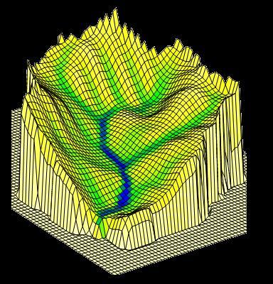
8 DEM 3D Viewing 8
9 DEM 3D Viewing 8
10 DEM 3D Viewing Flow direction
11 DEM 3D Viewing Flow direction Flow accumulation 8
12 DEM Threshold = 4 3D the drainage network is Viewing composed by all cells with flow accum 4 Flow direction Flow accumulation 8

13 DEM 3D Viewing Flow direction Drainage network Flow accumulation 8
 Flat area In general, these two cases are treated by a very time-consuming preprocessing step; 9")
14 In some cases, it is not possible to determine (directly) the flow direction in a cell: Local minimum (depression) Flat area In general, these two cases are treated by a very time-consuming preprocessing step; 9
15 A depression is removed by filling it; that is, its elevation is raised to the elevation of its lowest neighbor; And, the flow direction in flat areas is oriented to the lowest neighbor cell; But, in general, this preprocessing step takes more than 50% of the total running time; 10
16 To avoid this time-consuming preprocessing step, we developed the RWFlood method which is very efficient when the whole terrain fits in internal memory; 11
17 The basic idea of RWFlood is: supposing a terrain being flooded by water coming from outside and getting into the terrain through its boundary; the course of the water getting into the terrain will be the same as the water coming from rain and flowing downhill (that is, the flow direction); 13
 and the flooding process is simulated raising the water level;")
18 In other words, the idea is to suppose the terrain surrounded by water (as an island) and the flooding process is simulated raising the water level; 14
19 Initially, the water level is set to the elevation of the lowest cell in the terrain boundary; Then, two actions are executed iteratively: flooding a cell raising the water level 14
20 Flooding a cell c For all cells d neighbors to c do: if the elevation of d is smaller than the elevation of c then d is raised to the elevation of c; the flow direction of d is set to the cell c; 14
21 Raising the water level After flooding all cells considering the current water level H, the water is raised to the elevation of the lowest cell higher than H; 14
22 These cells are processed as previously and the level of the water is raised to the next level; 14
;")
23 Now, the cell to be processed has some neighbor cells whose elevation is smaller than the water level (a depression); 14

24 The depression is filled; This algorithm could be implemented using an stable priority queue. But, for performance purpose, we use an array of queues. 14
25 RWFlood was implemented to flood the terrain and to compute the flow direction in O(N) time; The flow accumulation can be easily computed (in linear time) using an algorithm based in topological sorting; But, it does not scale well for huge terrains requiring external memory processing; Thus, the idea of this work (the EMFLOW method) is to adapt the RWFlood for external processing; 15


26 Basically, RWFlood stores the cells in the boundary of flooded regions; Cells in the boundary of flooded region And these cells are processed based on their elevation: from the lowest to the highest; 16
27 When a cell is processed, it is necessary to access its neighbors; Which means the terrain matrix is accessed nonsequentially since the cells that are neighbors in the two-dimensional matrix representation may not be close in the memory; Thus, this process can be inefficient when the matrix is huge and is stored in external memory; 17
28 To reduce the number of disk accesses, we propose the EMFlow whose basic idea is to use a cache strategy to benefit from the spatial locality of reference present in the sequence of accesses. 18

 that are stored sequentially in the")
29 Spatial locality of reference: a special library, named TiledMatrix, is used to subdivide the matrix in squared blocks (of cells) that are stored sequentially in the external memory; 19
30 The blocks are managed as in a cache memory; When a cell needs to be accessed, the entire block containing this cell is loaded (and kept) in the memory. The next accesses to cells in this block can be done efficiently; When the internal memory is full, the blocks are replaced using the LRU policy. 20
31 In EMFLow, all matrices used in RWFlood are replaced by matrices managed by TiledMatrix; Supposing the blocks near the flooded region border can fit in the memory, the disk accesses are reduced. 21
32 EMFlow was implemented in C++; It was compared against TerraFlow and r.watershed.seg (both included in GRASS); Test machine rebooted with: 1GB and 4GB of memory to consider different scenarios; Computer: Intel Core 2 Duo 2.8 GHz, Ubuntu Linux bits with a 5400 RPM SATA HD; 22
33 Terrains from Nasa SRTM (30 meter); Processing times (s). EMFlow TerraFlow r.watershed.seg Terrain Memory Memory Memory Width 1GB 4GB 1GB 4GB 1GB 4GB > > > > > > > > >
34 24
35 25
36 We developed a very fast and simple algorithm to compute the drainage network on huge terrains stored in external memory; In huge terrains it was about 30 times faster than Terraflow. 26
37 Future work includes: A parameter that may affect the algorithm`s efficiency is the TiledMatrix block size. In future works we intend to run more tests to evaluate this influence. 27

38 Future work includes: The algorithm needs to keep in the memory the cells in the border of the flooded region. If this border is big and the TiledMatrix cache size is small, the cache may not be enough to store the blocks in this area. One way to avoid this is to identify islands during the flooding process and process each island separately. We intend to use this strategy to improve the method. 28


39 Acknowledgements

40 Drainage network on Tapajos basin computed by EMFlow
41 Drainage network on Tapajos basin computed by r.watershed
42 Drainage network on Tapajos basin computed by TerraFlow
A linear time algorithm to compute the drainage network on grid terrains
 A linear time algorithm to compute the drainage network on grid terrains Salles V. G. Magalhães 1, Marcus V. A. Andrade 1, W. Randolph Franklin 2 and Guilherme C. Pena 1 1 Department of Informatics (DPI)
A Parallel Sweep Line Algorithm for Visibility Computation
 Universidade Federal de Viçosa Departamento de Informática Programa de Pós-Graduação em Ciência da Computação A Parallel Sweep Line Algorithm for Visibility Computation Chaulio R. Ferreira Marcus V. A.
Flow on terrains. Laura Toma csci 3225 Algorithms for GIS Bowdoin College
 Flow on terrains Laura Toma csci 3225 Algorithms for GIS Bowdoin College Overview Flow on grids (discrete) flow direction flow accumulation algorithms for FD and FA dealing with flat areas watershed hierarchy
Massive Data Algorithmics
 In the name of Allah Massive Data Algorithmics An Introduction Overview MADALGO SCALGO Basic Concepts The TerraFlow Project STREAM The TerraStream Project TPIE MADALGO- Introduction Center for MAssive
Algorithms for GIS csci3225
 Algorithms for GIS csci3225 Laura Toma Bowdoin College Flow on digital terrain models (I) Flow Where does the water go when it rains? Flooding: What are the areas susceptible to flooding? Sea level rise:
Geographic Surfaces. David Tenenbaum EEOS 383 UMass Boston
 Geographic Surfaces Up to this point, we have talked about spatial data models that operate in two dimensions How about the rd dimension? Surface the continuous variation in space of a third dimension
Improved Visibility Computation on Massive Grid Terrains
 Improved Visibility Computation on Massive Grid Terrains Jeremy Fishman Herman Haverkort Laura Toma Bowdoin College USA Eindhoven University The Netherlands Bowdoin College USA Laura Toma ACM GIS 2009
A Parallel Sweep Line Algorithm for Visibility Computation
 A Parallel Sweep Line Algorithm for Visibility Computation Chaulio R. Ferreira 1, Marcus V. A. Andrade 1, Salles V. G. Magalhes 1, W. R. Franklin 2, Guilherme C. Pena 1 1 Departamento de Informática Universidade
Geographical Information System (Dam and Watershed Analysis)
") Geographical Information System (Dam and Watershed Analysis) Kumar Digvijay Singh 02D05012 Under Guidance of Prof. Milind Sohoni Outline o Watershed delineation o Sinks, flat areas, flow direction, delineation
Geographical Information System (Dam and Watershed Analysis) Kumar Digvijay Singh 02D05012 Under Guidance of Prof. Milind Sohoni Outline o Watershed delineation o Sinks, flat areas, flow direction, delineation
Extracting Topographic Structure from Digital Elevation Data for Geographic Information System Analysis
 Extracting Topographic Structure from Digital Elevation Data for Geographic Information System Analysis S.K. Jenson and J. O. Domingue TGS Technology, Inc., EROS Data Center, Sioux Falls, SD 57198 ABSTRACT:
An efficient GPU multiple-observer siting method based on sparse-matrix multiplication
 An efficient GPU multiple-observer siting method based on sparse-matrix multiplication Guilherme C. Pena Universidade Fed. de Viçosa Viçosa, MG, Brazil guilherme.pena@ufv.br W. Randolph Franklin Rensselaer
A parallel algorithm for viewshed computation on grid terrains
 A parallel algorithm for viewshed computation on grid terrains Chaulio R. Ferreira 1, Marcus V. A. Andrade 1, Salles V. G. Magalhães 1, W. R. Franklin 2, Guilherme C. Pena 1 1 Universidade Federal de Viçosa,
AutoCAD Civil 3D 2010 Education Curriculum Instructor Guide Unit 4: Environmental Design
 AutoCAD Civil 3D 2010 Education Curriculum Instructor Guide Unit 4: Environmental Design Lesson 2 Watershed Analysis Overview In this lesson, you learn about how AutoCAD Civil 3D software is used to analyze
Efficient Parallel GIS and CAD Operations on Very Large Data Sets
 Efficient Parallel GIS and CAD Operations on Very Large Data Sets W. Randolph Franklin, RPI 2016-10-31 What? design very fast computational geometry and GIS algorithms, and implement and test them on large
Delineating the Stream Network and Watersheds of the Guadalupe Basin
 Delineating the Stream Network and Watersheds of the Guadalupe Basin Francisco Olivera Department of Civil Engineering Texas A&M University Srikanth Koka Department of Civil Engineering Texas A&M University
Surface Analysis. Data for Surface Analysis. What are Surfaces 4/22/2010
 Surface Analysis Cornell University Data for Surface Analysis Vector Triangulated Irregular Networks (TIN) a surface layer where space is partitioned into a set of non-overlapping triangles Attribute and
WMS 9.1 Tutorial Watershed Modeling DEM Delineation Learn how to delineate a watershed using the hydrologic modeling wizard
 v. 9.1 WMS 9.1 Tutorial Learn how to delineate a watershed using the hydrologic modeling wizard Objectives Read a digital elevation model, compute flow directions, and delineate a watershed and sub-basins
WMS 9.1 Tutorial GSSHA Modeling Basics Stream Flow Integrate stream flow with your GSSHA overland flow model
 v. 9.1 WMS 9.1 Tutorial Integrate stream flow with your GSSHA overland flow model Objectives Learn how to add hydraulic channel routing to your GSSHA model and how to define channel properties. Learn how
Learn how to delineate a watershed using the hydrologic modeling wizard
 v. 10.1 WMS 10.1 Tutorial Learn how to delineate a watershed using the hydrologic modeling wizard Objectives Import a digital elevation model, compute flow directions, and delineate a watershed and sub-basins
Watershed Modeling Advanced DEM Delineation
 v. 10.1 WMS 10.1 Tutorial Watershed Modeling Advanced DEM Delineation Techniques Model manmade and natural drainage features Objectives Learn to manipulate the default watershed boundaries by assigning
EVALUATING AND COMPRESSING HYDROLOGY ON SIMPLIFIED TERRAIN
 EVALUATING AND COMPRESSING HYDROLOGY ON SIMPLIFIED TERRAIN By Jonathan Muckell A Thesis Submitted to the Graduate Faculty of Rensselaer Polytechnic Institute in Partial Fulfillment of the Requirements
Learn how to delineate a watershed using the hydrologic modeling wizard
 v. 11.0 WMS 11.0 Tutorial Learn how to delineate a watershed using the hydrologic modeling wizard Objectives Import a digital elevation model, compute flow directions, and delineate a watershed and sub-basins
An Improved Method for Watershed Delineation and Computation of Surface Depression Storage. PO Box 6050, Fargo, ND , United States
 1113 An Improved Method for Watershed Delineation and Computation of Surface Depression Storage Xuefeng Chu, A.M.ASCE 1,*, Jianli Zhang 1, Yaping Chi 1, Jun Yang 1 1 Department of Civil Engineering (Dept
Lab 11: Terrain Analyses
 Lab 11: Terrain Analyses What You ll Learn: Basic terrain analysis functions, including watershed, viewshed, and profile processing. There is a mix of old and new functions used in this lab. We ll explain
Field-Scale Watershed Analysis
 Conservation Applications of LiDAR Field-Scale Watershed Analysis A Supplemental Exercise for the Hydrologic Applications Module Andy Jenks, University of Minnesota Department of Forest Resources 2013
Lab 11: Terrain Analyses
 Lab 11: Terrain Analyses What You ll Learn: Basic terrain analysis functions, including watershed, viewshed, and profile processing. There is a mix of old and new functions used in this lab. We ll explain
WMS 10.1 Tutorial GSSHA WMS Basics Watershed Delineation using DEMs and 2D Grid Generation Delineate a watershed and create a GSSHA model from a DEM
 v. 10.1 WMS 10.1 Tutorial GSSHA WMS Basics Watershed Delineation using DEMs and 2D Grid Generation Delineate a watershed and create a GSSHA model from a DEM Objectives Learn how to delineate a watershed
An efficient map-reduce algorithm for spatio-temporal analysis using Spark (GIS Cup)
") Rensselaer Polytechnic Institute Universidade Federal de Viçosa An efficient map-reduce algorithm for spatio-temporal analysis using Spark (GIS Cup) Prof. Dr. W Randolph Franklin, RPI Salles Viana Gomes
Rensselaer Polytechnic Institute Universidade Federal de Viçosa An efficient map-reduce algorithm for spatio-temporal analysis using Spark (GIS Cup) Prof. Dr. W Randolph Franklin, RPI Salles Viana Gomes
Delineating Watersheds from a Digital Elevation Model (DEM)
") Delineating Watersheds from a Digital Elevation Model (DEM) (Using example from the ESRI virtual campus found at http://training.esri.com/courses/natres/index.cfm?c=153) Download locations for additional
Delineating Watersheds from a Digital Elevation Model (DEM) (Using example from the ESRI virtual campus found at http://training.esri.com/courses/natres/index.cfm?c=153) Download locations for additional
Lab 11: Terrain Analysis
 Lab 11: Terrain Analysis What You ll Learn: Basic terrain analysis functions, including watershed, viewshed, and profile processing. You should read chapter 11 in the GIS Fundamentals textbook before performing
WMS 10.0 Tutorial Hydraulics and Floodplain Modeling HY-8 Modeling Wizard Learn how to model a culvert using HY-8 and WMS
 v. 10.0 WMS 10.0 Tutorial Hydraulics and Floodplain Modeling HY-8 Modeling Wizard Learn how to model a culvert using HY-8 and WMS Objectives Define a conceptual schematic of the roadway, invert, and downstream
A fast watershed algorithm based on chain code and its application in image segmentation
 Pattern Recognition Letters 26 (2005) 1266 1274 www.elsevier.com/locate/patrec A fast watershed algorithm based on chain code and its application in image segmentation Han Sun *, Jingyu Yang, Mingwu Ren
Watershed Modeling With DEMs: The Rest of the Story
 Watershed Modeling With DEMs: The Rest of the Story Lesson 7 7-1 DEM Delineation: The Rest of the Story DEM Fill for some cases when merging DEMs Delineate Basins Wizard Smoothing boundaries Representing
Query Answering Using Inverted Indexes
 Query Answering Using Inverted Indexes Inverted Indexes Query Brutus AND Calpurnia J. Pei: Information Retrieval and Web Search -- Query Answering Using Inverted Indexes 2 Document-at-a-time Evaluation
Flow Computation on Massive Grid Terrains
 Flow Computation on Massive Grid Terrains Lars Arge, Jeffrey S. Chase, Patrick Halpin, Laura Toma, Jeffrey S. Vitter, Dean Urban, Rajiv Wickremesinghe As detailed terrain data becomes available, GIS terrain
Raster Analysis. Overview Neighborhood Analysis Overlay Cost Surfaces. Arthur J. Lembo, Jr. Salisbury University
 Raster Analysis Overview Neighborhood Analysis Overlay Cost Surfaces Exam results Mean: 74% STDEV: 15% High: 92 Breakdown: A: 1 B: 2 C: 2 D: 1 F: 2 We will review the exam next Tuesday. Start thinking
Automatic Discretization and Parameterization of Watersheds using a Digital Elevation Model
 Automatic Discretization and Parameterization of Watersheds using a Digital Elevation Model Ellen Hachborn, Karen Finney, Rob James, Nandana Perera, Tiehong Xiao WaterTech 2017 Computational Hydraulics
Applied Cartography and Introduction to GIS GEOG 2017 EL. Lecture-7 Chapters 13 and 14
 Applied Cartography and Introduction to GIS GEOG 2017 EL Lecture-7 Chapters 13 and 14 Data for Terrain Mapping and Analysis DEM (digital elevation model) and TIN (triangulated irregular network) are two
Modeling Watershed Geomorphology
 W A T E R S H E D S Tutorial Modeling Watersheds Modeling Watershed Geomorphology with TNTmips page 1 Before Getting Started The movement of water over land surfaces is an important environmental factor
Creating and Delineating a Watershed from DXF Terrain Data
 Creating and Delineating a Watershed from DXF Terrain Data 1. Start up WMS. 2. Switch to the Map Module. 3. Select DXF Import. Select the DXF file to import. 4. Notice that the DXF file imports fine into
WMS 9.1 Tutorial GSSHA WMS Basics Watershed Delineation using DEMs and 2D Grid Generation Delineate a watershed and create a GSSHA model from a DEM
 v. 9.1 WMS 9.1 Tutorial GSSHA WMS Basics Watershed Delineation using DEMs and 2D Grid Generation Delineate a watershed and create a GSSHA model from a DEM Objectives Learn how to delineate a watershed
Hydraulics and Floodplain Modeling Modeling with the Hydraulic Toolbox
 v. 9.1 WMS 9.1 Tutorial Hydraulics and Floodplain Modeling Modeling with the Hydraulic Toolbox Learn how to design inlet grates, detention basins, channels, and riprap using the FHWA Hydraulic Toolbox
J.Welhan 5/07. Watershed Delineation Procedure
 Watershed Delineation Procedure 1. Prepare the DEM: - all grids should be in the same projection; if not, then reproject (or define and project); if in UTM, all grids must be in the same zone (if not,
Lesson 5 overview. Concepts. Interpolators. Assessing accuracy Exercise 5
 Interpolation Tools Lesson 5 overview Concepts Sampling methods Creating continuous surfaces Interpolation Density surfaces in GIS Interpolators IDW, Spline,Trend, Kriging,Natural neighbors TopoToRaster
Developing an Interactive GIS Tool for Stream Classification in Northeast Puerto Rico
 Developing an Interactive GIS Tool for Stream Classification in Northeast Puerto Rico Lauren Stachowiak Advanced Topics in GIS Spring 2012 1 Table of Contents: Project Introduction-------------------------------------
ADVANCED TERRAIN PROCESSING: ANALYTICAL RESULTS OF FILLING VOIDS IN REMOTELY SENSED DATA TERRAIN INPAINTING
 ADVANCED TERRAIN PROCESSING: ANALYTICAL RESULTS OF FILLING VOIDS IN REMOTELY SENSED DATA J. Harlan Yates Patrick Kelley Josef Allen Mark Rahmes Harris Corporation Government Communications Systems Division
Stream Network and Watershed Delineation using Spatial Analyst Hydrology Tools
 Stream Network and Watershed Delineation using Spatial Analyst Hydrology Tools Prepared by Venkatesh Merwade School of Civil Engineering, Purdue University vmerwade@purdue.edu January 2018 Objective The
Parallel calculation of LS factor for regional scale soil erosion assessment
 Parallel calculation of LS factor for regional scale soil erosion assessment Kai Liu 1, Guoan Tang 2 1 Key Laboratory of Virtual Geographic Environment (Nanjing Normal University), Ministry of Education,
DIGITAL IMAGE ANALYSIS. Image Classification: Object-based Classification
 DIGITAL IMAGE ANALYSIS Image Classification: Object-based Classification Image classification Quantitative analysis used to automate the identification of features Spectral pattern recognition Unsupervised
Raster Analysis. Overview Neighborhood Analysis Overlay Cost Surfaces. Arthur J. Lembo, Jr. Salisbury University
 Raster Analysis Overview Neighborhood Analysis Overlay Cost Surfaces Why we use Raster GIS In our previous discussion of data models, we indicated that Raster GIS is often used because: Raster is better
APPENDIX E2. Vernal Pool Watershed Mapping
 APPENDIX E2 Vernal Pool Watershed Mapping MEMORANDUM To: U.S. Fish and Wildlife Service From: Tyler Friesen, Dudek Subject: SSHCP Vernal Pool Watershed Analysis Using LIDAR Data Date: February 6, 2014
AUTOMATIC EXTRACTION OF TERRAIN SKELETON LINES FROM DIGITAL ELEVATION MODELS
 AUTOMATIC EXTRACTION OF TERRAIN SKELETON LINES FROM DIGITAL ELEVATION MODELS F. Gülgen, T. Gökgöz Yildiz Technical University, Department of Geodetic and Photogrammetric Engineering, 34349 Besiktas Istanbul,
Import, view, edit, convert, and digitize triangulated irregular networks
 v. 10.1 WMS 10.1 Tutorial Import, view, edit, convert, and digitize triangulated irregular networks Objectives Import survey data in an XYZ format. Digitize elevation points using contour imagery. Edit
An efficient algorithm to compute the viewshed on DEM terrains stored in the external memory
 An efficient algorithm to compute the viewshed on DEM terrains stored in the external memory Mirella A. Magalhães 1, Salles V. G. Magalhães 1, Marcus V. A. Andrade 1, Jugurta Lisboa Filho 1 1 Departamento
2D Model Implementation for Complex Floodplain Studies. Sam Crampton, P.E., CFM Dewberry
 2D Model Implementation for Complex Floodplain Studies Sam Crampton, P.E., CFM Dewberry 2D Case Studies Case Study 1 Rain-on-Grid 2D floodplain simulation for unconfined flat topography in coastal plain
Automated Enforcement of High Resolution Terrain Models April 21, Brian K. Gelder, PhD Associate Scientist Iowa State University
 Automated Enforcement of High Resolution Terrain Models April 21, 2015 Brian K. Gelder, PhD Associate Scientist Iowa State University Problem Statement High resolution digital elevation models (DEMs) should
v Prerequisite Tutorials GSSHA Modeling Basics Stream Flow GSSHA WMS Basics Creating Feature Objects and Mapping their Attributes to the 2D Grid
 v. 10.1 WMS 10.1 Tutorial GSSHA Modeling Basics Developing a GSSHA Model Using the Hydrologic Modeling Wizard in WMS Learn how to setup a basic GSSHA model using the hydrologic modeling wizard Objectives
Computing Visibility on Terrains in External Memory
 Computing Visibility on Terrains in External Memory Herman Haverkort Laura Toma Yi Zhuang TU. Eindhoven Netherlands Bowdoin College USA Visibility Problem: visibility map (viewshed) of v terrain T arbitrary
Watershed Delineation
 Watershed Delineation Using SAGA GIS Tutorial ID: IGET_SA_003 This tutorial has been developed by BVIEER as part of the IGET web portal intended to provide easy access to geospatial education. This tutorial
Improved Applications with SAMB Derived 3 meter DTMs
 Improved Applications with SAMB Derived 3 meter DTMs Evan J Fedorko West Virginia GIS Technical Center 20 April 2005 This report sums up the processes used to create several products from the Lorado 7
Another Fast and Simple DEM Depression-Filling Algorithm Based on Priority Queue Structure
 ATMOSPHERIC AND OCEANIC SCIENCE LETTERS, 2009, VOL. 2, NO. 4, 214 219 Another Fast and Simple DEM Depression-Filling Algorithm Based on Priority Queue Structure LIU Yong-He 1, ZHANG Wan-Chang 2, and XU
R STREAM A GRASS GIS TOOLBOX FOR ADVANCED HYDROGEOMORPHOLOGICAL MODELING COURSE DESCRIPTION r stream is a comprehensive and flexible hydro-geomorpholo
 COURSE DESCRIPTION r stream is a comprehensive and flexible hydro-geomorphological modeling tool written as an extension for GRASS GIS. The toolbox is optimized to work with really huge datasets (of hundreds
LECTURE 2 SPATIAL DATA MODELS
 LECTURE 2 SPATIAL DATA MODELS Computers and GIS cannot directly be applied to the real world: a data gathering step comes first. Digital computers operate in numbers and characters held internally as binary
Parallel Flow-Direction and Contributing Area Calculation for Hydrology Analysis in Digital Elevation Models
 1 Parallel Flow-Direction and Contributing Area Calculation for Hydrology Analysis in Digital Elevation Models Chase Wallis Dan Watson David Tarboton Robert Wallace Computer Science Computer Science Civil
Computing Pfafstetter Labelings I/O-Efficiently (abstract)
") Computing Pfafstetter Labelings I/O-Efficiently (abstract) Lars Arge Department of Computer Science, University of Aarhus Aabogade 34, DK-8200 Aarhus N, Denmark large@daimi.au.dk Herman Haverkort Dept.
Computing Pfafstetter Labelings I/O-Efficiently (abstract) Lars Arge Department of Computer Science, University of Aarhus Aabogade 34, DK-8200 Aarhus N, Denmark large@daimi.au.dk Herman Haverkort Dept.
Hydrologic Terrain Processing Using Parallel Computing
 18 th World IMACS / MODSIM Congress, Cairns, Australia 13-17 July 2009 http://mssanz.org.au/modsim09 Hydrologic Terrain Processing Using Parallel Computing Wallis, C. 1, R. Wallace 3, D.G. Tarboton 2,
Watershed Analysis and A Look Ahead
 Watershed Analysis and A Look Ahead 1 2 Specific Storm Flow to Grate What data do you need? Watershed boundaries for each storm sewer Net flow generated from each point across the landscape Elevation Fill
How to Apply the Geospatial Data Abstraction Library (GDAL) Properly to Parallel Geospatial Raster I/O?
 Properly to Parallel Geospatial Raster I/O?") bs_bs_banner Short Technical Note Transactions in GIS, 2014, 18(6): 950 957 How to Apply the Geospatial Data Abstraction Library (GDAL) Properly to Parallel Geospatial Raster I/O? Cheng-Zhi Qin,* Li-Jun
bs_bs_banner Short Technical Note Transactions in GIS, 2014, 18(6): 950 957 How to Apply the Geospatial Data Abstraction Library (GDAL) Properly to Parallel Geospatial Raster I/O? Cheng-Zhi Qin,* Li-Jun
Computing Visibility on Terrains in External Memory
 Computing Visibility on Terrains in External Memory Herman Haverkort Laura Toma Yi Zhuang TU. Eindhoven Netherlands Bowdoin College USA ALENEX 2007 New Orleans, USA Visibility Problem: visibility map (viewshed)
Stream network delineation and scaling issues with high resolution data
 Stream network delineation and scaling issues with high resolution data Roman DiBiase, Arizona State University, May 1, 2008 Abstract: In this tutorial, we will go through the process of extracting a stream
Memory Hierarchy. Jin-Soo Kim Computer Systems Laboratory Sungkyunkwan University
 Memory Hierarchy Jin-Soo Kim (jinsookim@skku.edu) Computer Systems Laboratory Sungkyunkwan University http://csl.skku.edu Time (ns) The CPU-Memory Gap The gap widens between DRAM, disk, and CPU speeds
Hardware Sizing Guide OV
 Hardware Sizing Guide OV3600 6.3 www.alcatel-lucent.com/enterprise Part Number: 0510620-01 Table of Contents Table of Contents... 2 Overview... 3 Properly Sizing Processing and for your OV3600 Server...
Line Segment Based Watershed Segmentation
 Line Segment Based Watershed Segmentation Johan De Bock 1 and Wilfried Philips Dep. TELIN/TW07, Ghent University Sint-Pietersnieuwstraat 41, B-9000 Ghent, Belgium jdebock@telin.ugent.be Abstract. In this
Properly Sizing Processing and Memory for your AWMS Server
 Overview This document provides guidelines for purchasing new hardware which will host the AirWave Wireless Management System. Your hardware should incorporate margin for WLAN expansion as well as future
T-vector manual. Author: Arnaud Temme, November Introduction
 T-vector manual Author: Arnaud Temme, November 2010 Introduction The T-vector calculation utility was written as part of a research project of the department of Land Dynamics at Wageningen University the
Large and Sparse Mass Spectrometry Data Processing in the GPU Jose de Corral 2012 GPU Technology Conference
 Large and Sparse Mass Spectrometry Data Processing in the GPU Jose de Corral 2012 GPU Technology Conference 2012 Waters Corporation 1 Agenda Overview of LC/IMS/MS 3D Data Processing 4D Data Processing
Metrics assessments Toolset name : METRICS
 User guide for FluvialCorridor toolbox Metrics assessments Toolset name : METRICS Tool s names : Elevation and slope Morphometry Watershed Width Contact length Discontinuities How to cite : Roux, C., Alber,
WMS 9.0 Tutorial GSSHA WMS Basics Watershed Delineation using DEMs and 2D Grid Generation Delineate a watershed and create a GSSHA model from a DEM
 v. 9.0 WMS 9.0 Tutorial GSSHA WMS Basics Watershed Delineation using DEMs and 2D Grid Generation Delineate a watershed and create a GSSHA model from a DEM Objectives Learn how to delineate a watershed
Lab 12: Sampling and Interpolation
 Lab 12: Sampling and Interpolation What You ll Learn: -Systematic and random sampling -Majority filtering -Stratified sampling -A few basic interpolation methods Data for the exercise are in the L12 subdirectory.
memory Abstract The recent availability of detailed geographic data permits terrain applications
 Efficient viewshed computation on terrain in external memory Marcus V. A. Andrade 1,2, Salles V. G. Magalhães 1, Mirella A. Magalhães 1, W. Randolph Franklin 2, and Barbara M. Cutler 3 1 DPI, Universidade
George Mason University Department of Civil, Environmental and Infrastructure Engineering
 George Mason University Department of Civil, Environmental and Infrastructure Engineering Dr. Celso Ferreira Prepared by Lora Baumgartner December 2015 Revised by Brian Ross July 2016 Exercise Topic: Getting
EIDE, ATA, SATA, USB,
 Magnetic disks provide bulk of secondary storage of modern computers! Drives rotate at 60 to 200 times per second! Transfer rate is rate at which data flow between drive and computer! Positioning time
Channel Conditions in the Onion Creek Watershed. Integrating High Resolution Elevation Data in Flood Forecasting
 Channel Conditions in the Onion Creek Watershed Integrating High Resolution Elevation Data in Flood Forecasting Lukas Godbout GIS in Water Resources CE394K Fall 2016 Introduction Motivation Flooding is
v. 9.1 WMS 9.1 Tutorial Watershed Modeling HEC-1 Interface Learn how to setup a basic HEC-1 model using WMS
 v. 9.1 WMS 9.1 Tutorial Learn how to setup a basic HEC-1 model using WMS Objectives Build a basic HEC-1 model from scratch using a DEM, land use, and soil data. Compute the geometric and hydrologic parameters
Visually appealing water flow over a terrain
 Visually appealing water flow over a terrain Eddie Lau CSCI-6530 Advanced Computer Graphics Final Project 2010 Rensselaer Polytechnic Institute Figure 1: Water flow simulation of a scene with three water
GIS in agriculture scale farm level - used in agricultural applications - managing crop yields, monitoring crop rotation techniques, and estimate
 Types of Input GIS in agriculture scale farm level - used in agricultural applications - managing crop yields, monitoring crop rotation techniques, and estimate soil loss from individual farms or agricultural
GIS OPERATION MANUAL
 GIS OPERATION MANUAL 1. Computer System Description Hardware Make Compaq Presario 5004 CPU AMD Athlon 1.1 Ghz Main Memory 640MB CD-ROM 52 X CD-RW 8 X HD 57GB Monitor 19 inch Video Adapter 16 Mb Nvidia
L7 Raster Algorithms
 L7 Raster Algorithms NGEN6(TEK23) Algorithms in Geographical Information Systems by: Abdulghani Hasan, updated Nov 216 by Per-Ola Olsson Background Store and analyze the geographic information: Raster
GIS LAB 8. Raster Data Applications Watershed Delineation
 GIS LAB 8 Raster Data Applications Watershed Delineation This lab will require you to further your familiarity with raster data structures and the Spatial Analyst. The data for this lab are drawn from
Massive Data Algorithmics
 Massive Data Algorithmics University of Aarhus Department of Computer Science Faglig Dag, January 17, 2008 running time The core problem... Normal algorithm I/O-efficient algorithm data size Main memory
Level 2 Diploma Unit 3 Computer Systems
 Level 2 Diploma Unit 3 Computer Systems You are an IT technician in a small company which creates web sites. The company has recently employed someone who is partially sighted and is also left handed.
Parallel Geospatial Data Management for Multi-Scale Environmental Data Analysis on GPUs DOE Visiting Faculty Program Project Report
 Parallel Geospatial Data Management for Multi-Scale Environmental Data Analysis on GPUs 2013 DOE Visiting Faculty Program Project Report By Jianting Zhang (Visiting Faculty) (Department of Computer Science,
Disk scheduling Disk reliability Tertiary storage Swap space management Linux swap space management
 Lecture Overview Mass storage devices Disk scheduling Disk reliability Tertiary storage Swap space management Linux swap space management Operating Systems - June 28, 2001 Disk Structure Disk drives are
Contents of Lecture. Surface (Terrain) Data Models. Terrain Surface Representation. Sampling in Surface Model DEM
 Data Models. Terrain Surface Representation. Sampling in Surface Model DEM") Lecture 13: Advanced Data Models: Terrain mapping and Analysis Contents of Lecture Surface Data Models DEM GRID Model TIN Model Visibility Analysis Geography 373 Spring, 2006 Changjoo Kim 11/29/2006 1
Lecture 13: Advanced Data Models: Terrain mapping and Analysis Contents of Lecture Surface Data Models DEM GRID Model TIN Model Visibility Analysis Geography 373 Spring, 2006 Changjoo Kim 11/29/2006 1
Machine Learning 13. week
 Machine Learning 13. week Deep Learning Convolutional Neural Network Recurrent Neural Network 1 Why Deep Learning is so Popular? 1. Increase in the amount of data Thanks to the Internet, huge amount of
Watershed Modeling Orange County Hydrology Using GIS Data
 v. 9.1 WMS 9.1 Tutorial Watershed Modeling Orange County Hydrology Using GIS Data Learn how to delineate sub-basins and compute soil losses for Orange County (California) hydrologic modeling Objectives
Use of open-source GIS for the preprocessing of distributed hydrological. models
 Use of open-source GIS for the preprocessing of distributed hydrological models F. Branger, I. Braud, S. Debionne, J. Dehotin, S. Jankowfsky, O. Vannier, P. Viallet Who are we? Cemagref Hydrology-Hydraulics
WMS 8.4 Tutorial Watershed Modeling MODRAT Interface (GISbased) Delineate a watershed and build a MODRAT model
 Delineate a watershed and build a MODRAT model") v. 8.4 WMS 8.4 Tutorial Watershed Modeling MODRAT Interface (GISbased) Delineate a watershed and build a MODRAT model Objectives Delineate a watershed from a DEM and derive many of the MODRAT input parameters
v. 8.4 WMS 8.4 Tutorial Watershed Modeling MODRAT Interface (GISbased) Delineate a watershed and build a MODRAT model Objectives Delineate a watershed from a DEM and derive many of the MODRAT input parameters
WMS 8.4 Tutorial Watershed Modeling MODRAT Interface Schematic Build a MODRAT model by defining a hydrologic schematic
 v. 8.4 WMS 8.4 Tutorial Watershed Modeling MODRAT Interface Schematic Build a MODRAT model by defining a hydrologic schematic Objectives This tutorial shows you how to define a basic MODRAT model using
C E N T E R A T H O U S T O N S C H O O L of H E A L T H I N F O R M A T I O N S C I E N C E S. Image Operations II
 T H E U N I V E R S I T Y of T E X A S H E A L T H S C I E N C E C E N T E R A T H O U S T O N S C H O O L of H E A L T H I N F O R M A T I O N S C I E N C E S Image Operations II For students of HI 5323