Linear Routing: Floodrouting. HEC-RAS Introduction. Brays Bayou. Uniform Open Channel Flow. v = 1 n R2/3. S S.I. units
|
|
|
- Junior Brooks
- 6 years ago
- Views:
Transcription
 types of floodrouting of a hydrograph Linear Muskingum Reservoir Storage-Indication / Modified Puls Hydrograph")


1 Linear Routing: Floodrouting HEC-RAS Introduction Shirley Clark Penn State Harrisburg Robert Pitt University of Alabama April 26, 2004 Two (2) types of floodrouting of a hydrograph Linear Muskingum Reservoir Storage-Indication / Modified Puls Hydrograph (Flow versus Time). Floodrouting input of the inflow hydrograph into a Wedge (Linear) or a Pond (Reservoir). The outflow hydrograph will be dampened such that the outflow hydrograph s peak will be less and delayed. Uniform Open Channel Flow Manning s Eqn for velocity or flow Uniform Open Channel Flow Brays B. Brays Bayou v = 1 n R2/3 S S.I. units v = 1.49 S English units n R2/3 where n = Manning s roughness coefficient R = hydraulic radius = A/P S = channel slope Q = flow rate (cfs) = v A Concrete Channel 1
2 Optimal Channels Non-uniform Flow 2

 Thus, dh dx = dz dx + dy dx + α 2g dv 2 dx Backwater Profiles -")
3 Non-Uniform Open Channel Flow With natural or man-made channels, the shape, size, and slope may vary along the stream length, x. In addition, velocity and flow rate may also vary with x. H = z+ y + α v 2 /2g ( ) Thus, dh dx = dz dx + dy dx + α 2g dv 2 dx Backwater Profiles - Compute Numerically Where H = total energy head z = elevation head, αv 2 /2g = velocity head 3
 7. Calculate A 2 8. Calculate P 2 9. Calculate R 2 = A 2 /P 2 10. Calculate V 2 = Q 2 /A 2 Backwater Calculations (cont d) 1. Prepare a table of values 2.")
4 Routine Backwater Calculations 1. Select Y 1 (starting depth) 2. Calculate A 1 (cross sectional area) 3. Calculate P 1 (wetted perimeter) 4. Calculate R 1 = A 1 /P 1 5. Calculate V 1 = Q 1 /A 1 6. Select Y 2 (ending depth) 7. Calculate A 2 8. Calculate P 2 9. Calculate R 2 = A 2 /P Calculate V 2 = Q 2 /A 2 Backwater Calculations (cont d) 1. Prepare a table of values 2. Calculate V m = (V 1 + V 2 ) / 2 3. Calculate R m = (R 1 + R 2 ) / Calculate S = nv m 2 Manning s 1.49R 3 m 2 y 1 + v 1 2g y + v g 5. Calculate L = X from first equation L = S S 0 6. X = X i for each stream reach (SEE SPREADSHEET) Floodplain Bridge Section Watershed Hydraulics Tributary Main Stream D C B A Cross Sections Bridge Q D Q C Q B Q A HEC-RAS: Background River Analysis System model of the U.S. Army Corps of Engineers Input = cross-section geometry and flow rates Output = flood water elevations Cross-Section Schematic Normal Water Surface Floodway Left Bank Station Main Channel Flood Water Surface Floodway Right Bank Station Cross Sections 4
 coordinates ProfileLine CrossSectionLine Example Example Calculate the water surface profiles for two discharges in the channel described in the following tables.")
5 HEC-RAS: Cross-Section Description 3-Dimensional River Channel Points describe channel and floodway geometry Bank station locations Water surface elevations and floodplain boundaries Each point has (x,y,z) coordinates ProfileLine CrossSectionLine Example Example Calculate the water surface profiles for two discharges in the channel described in the following tables. Q 1 = cfs Q 2 = cfs Assume a Manning s n of 0.24 for the two overbanks and a Manning s n of 0.04 for the channel. Assume the overbank distances between stations are the same as the distances between the stations in the channel. Section 1 Down L = 0 ft X Y Section 2 Down L = 1500 ft X Y Section 3 Down L = 2100 ft X Y


6 Section 4 Down L = 2000 ft X Y Example Section 5 Down L = 3150 ft X Y Section 6 Down L = 1855 ft X Y Open HEC-RAS (River Analysis System) by double-clicking on the icon (after installing the program). The following screen should appear: Select File New Project This screen should appear. Fill in the needed data. Then click OK. 6

.")

7 The introductory screen should appear with the project name filled in. Need to add geometric data (cross-section data). Click on Geometric Data button (tree). Need to add geometric data (crosssection data). Click on Geometric Data button (tree). Add River Reach by leftclicking on the River Reach button. 7
, a box will appear asking you to name the river and the reach. The result will look like the screen to the right.")
8 In the tablet area, left-click where you want the reach to start and use the pencil to draw the reach. Double left-click when Reach is completed. Once the reach is drawn (ended by left double-click), a box will appear asking you to name the river and the reach. The result will look like the screen to the right. Next will need to describe cross-sections in the reach. (or can add additional reaches that drain to same outlet). Left-click on the crosssection button on the left. 8


9 The following table should appear. Under Options, select Add New Cross-Section. When the box appears, enter the station number in the reach. Enter the data as required in each of the boxes and then click Apply Data. 9


 screen.")
10 After clicking on Apply Data, the plot should appear. When all cross-sections are entered and the data applied, select Exit Cross-Section Editor. This will return the active screen to the Geometric Data screen. Need to save the geometric data. This will return the introductory (project organization) screen. Want to enter the conditions necessary to perform the steady-state flow example. Click on steady-state flow button. 10
.")

11 The Steady-Flow Data screen will appear. Enter the data (enter number of profiles and the Q values). Select the button Reach Boundary Conditions. The following screen will appear. Click on desired boundary condition. Example will use Normal Depth. 11


12 Normal Depth requires entry of downstream slope at outlet. Use same slope as channel from Stations 2 to 1. Once boundary conditions have been entered, save the flow data and click OK. After saving, return to the introductory screen. The names of the data files for the Project, Geometry and Steady Flow should be showing. After saving, return to the introductory screen. The names of the data files for the Project, Geometry and Steady Flow should be showing. 12


13 Click on the Perform a Steady Flow Simulation button. Select New Plan. Fill in the Plan Name and Short ID. The screen now should look like this. Click on COMPUTE to run the simulation. 13


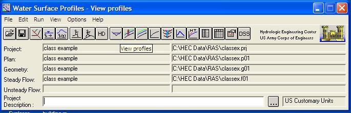
14 This screen will appear when the simulation is complete. Select View Cross-Sections. Select View Profiles. 14


15 Select View 3D Multiple Cross-Section Plot. Select Profile Table Output button. 15


16 Use Options to show both profiles. Use Options to show detailed cross-section output. Connecting HMS and RAS Discharge at a Particular Cross-Section 16


17 HEC-RAS: Output Graphical Text File HEC-RAS: Data Translation Data translation from HEC-RAS text file to dbase table Bank and floodplain boundaries measured from stream centerline Brays Bayou-Typical Urban System The Floodplain Bridges cause unique problems in hydraulics Piers, low chords, and top of road is considered Expansion/contraction can cause hydraulic losses Several cross sections are needed for a bridge Critical in urban settings 288 Crossing Top Width 17


18 Floodplain Determination The Woodlands The Woodlands planners wanted to design the community to withstand a 100-year storm. In doing this, they would attempt to minimize any changes to the existing, undeveloped floodplain as development proceeded through time. HEC RAS Cross Section 3-D Floodplain 18
The HEC-RAS Model Refresher
 The HEC-RAS Model Refresher Minmin Shu P.E. Transportation Review Unit Water Resources Division Michigan Department of Environmental Quality 12-6-2018 What Does the HEC-RAS Mean RAS----River Analysis System
CHAPTER 7 FLOOD HYDRAULICS & HYDROLOGIC VIVEK VERMA
 CHAPTER 7 FLOOD HYDRAULICS & HYDROLOGIC VIVEK VERMA CONTENTS 1. Flow Classification 2. Chezy s and Manning Equation 3. Specific Energy 4. Surface Water Profiles 5. Hydraulic Jump 6. HEC-RAS 7. HEC-HMS
Prepared for CIVE 401 Hydraulic Engineering By Kennard Lai, Patrick Ndolo Goy & Dr. Pierre Julien Fall 2015
 Prepared for CIVE 401 Hydraulic Engineering By Kennard Lai, Patrick Ndolo Goy & Dr. Pierre Julien Fall 2015 Contents Introduction General Philosophy Overview of Capabilities Applications Computational
Cross Sections, Profiles, and Rating Curves. Viewing Results From The River System Schematic. Viewing Data Contained in an HEC-DSS File
 C H A P T E R 9 Viewing Results After the model has finished the steady or unsteady flow computations the user can begin to view the output. Output is available in a graphical and tabular format. The current
Efficiency and Accuracy of Importing HEC RAS Datafiles into PCSWMM and SWMM5
 5 Efficiency and Accuracy of Importing HEC RAS Datafiles into PCSWMM and SWMM5 Karen Finney, Rob James, William James and Tiehong Xiao An advantage of USEPA s SWMM5 is its capability to dynamically model
WMS 9.0 Tutorial Hydraulics and Floodplain Modeling HEC-RAS Analysis Learn how to setup a basic HEC-RAS analysis using WMS
 v. 9.0 WMS 9.0 Tutorial Hydraulics and Floodplain Modeling HEC-RAS Analysis Learn how to setup a basic HEC-RAS analysis using WMS Objectives Learn how to build cross sections, stream centerlines, and bank
PRACTICAL UNIT 1 exercise task
 Practical Unit 1 1 1 PRACTICAL UNIT 1 exercise task Developing a hydraulic model with HEC RAS using schematic river geometry data In the course of practical unit 1 we prepare the input for the execution
WMS 10.1 Tutorial Hydraulics and Floodplain Modeling HEC-RAS Analysis Learn how to setup a basic HEC-RAS analysis using WMS
 v. 10.1 WMS 10.1 Tutorial Hydraulics and Floodplain Modeling HEC-RAS Analysis Learn how to setup a basic HEC-RAS analysis using WMS Objectives Learn how to build cross sections, stream centerlines, and
UNDERSTAND HOW TO SET UP AND RUN A HYDRAULIC MODEL IN HEC-RAS CREATE A FLOOD INUNDATION MAP IN ARCGIS.
 CE 412/512, Spring 2017 HW9: Introduction to HEC-RAS and Floodplain Mapping Due: end of class, print and hand in. HEC-RAS is a Hydrologic Modeling System that is designed to describe the physical properties
Introducion to Hydrologic Engineering Centers River Analysis System (HEC- RAS) Neena Isaac Scientist D CWPRS, Pune -24
 Neena Isaac Scientist D CWPRS, Pune -24") Introducion to Hydrologic Engineering Centers River Analysis System (HEC- RAS) Neena Isaac Scientist D CWPRS, Pune -24 One dimensional river models (1-D models) Assumptions Flow is one dimensional Streamline
Introducion to Hydrologic Engineering Centers River Analysis System (HEC- RAS) Neena Isaac Scientist D CWPRS, Pune -24 One dimensional river models (1-D models) Assumptions Flow is one dimensional Streamline
George Mason University Department of Civil, Environmental and Infrastructure Engineering. Dr. Celso Ferreira Prepared by Lora Baumgartner
 George Mason University Department of Civil, Environmental and Infrastructure Engineering Dr. Celso Ferreira Prepared by Lora Baumgartner Exercise Topic: Getting started with HEC RAS Objective: Create
HEC-RAS. A Tutorial (Model Development of a Small Flume)
") HEC-RAS A Tutorial (Model Development of a Small Flume) HEC-RAS Hydraulic Engineering Center:River Analysis System 1-D step backwater model Utilizes energy equation to compute water surface elevation for
HEC-RAS A Tutorial (Model Development of a Small Flume) HEC-RAS Hydraulic Engineering Center:River Analysis System 1-D step backwater model Utilizes energy equation to compute water surface elevation for
Storm Drain Modeling HY-12 Pump Station
 v. 10.1 WMS 10.1 Tutorial Storm Drain Modeling HY-12 Pump Station Analysis Setup a simple HY-12 pump station storm drain model in the WMS interface with pump and pipe information Objectives Using the HY-12
FLOODPLAIN MODELING USING HEC-RAS
 H A E S T A D M E T H O D S FLOODPLAIN MODELING USING HEC-RAS F i r s t E d i t i o n Authors Haestad Methods Gary Dyhouse Jennifer Hatchett Jeremy Benn Managing Editor Colleen Totz Editors David Klotz,
Watershed Modeling HEC-HMS Interface
 v. 10.1 WMS 10.1 Tutorial Learn how to set up a basic HEC-HMS model using WMS Objectives Build a basic HEC-HMS model from scratch using a DEM, land use, and soil data. Compute the geometric and hydrologic
HCFCD Review Process
 HCFCD Review Process Impact Analysis Local Review LOMR Delegation Local Review This presentation will include: Why is this step important? Process Review Checklist Common Comments 2 Local Review Why is
Flood Inundation Mapping using HEC-RAS
 Flood Inundation Mapping using HEC-RAS Goodell, C. 1 ; Warren, C. 2 WEST Consultants, 2601 25 th St SE, Suite 450, Salem, OR 97302. Abstract Flood inundation mapping is an important tool for municipal
FLOODPLAIN MODELING MANUAL. HEC-RAS Procedures for HEC-2 Modelers
 FLOODPLAIN MODELING MANUAL HEC-RAS Procedures for HEC-2 Modelers Federal Emergency Management Agency Mitigation Directorate 500 C Street, SW Washington, DC 20472 April 2002 Floodplain Modeling Manual HEC-RAS
Steady Flow Water Surface Profile Computation Using HEC-RAS
 Steady Flow Water Surface Profile Computation Using HEC-RAS Objectives The objective of the course is to enable the participants to perform water surface profile computations using computer program HEC-RAS
Numerical Hydraulics
 ETHZ, Fall 2017 Numerical Hydraulics Assignment 3 Comparison of two numerical solutions of river flow: use of Finite Elements (HEC-RAS) and Finite Volumes (BASEMENT) 1 Introduction In the course, two different
v. 9.1 WMS 9.1 Tutorial Watershed Modeling HEC-1 Interface Learn how to setup a basic HEC-1 model using WMS
 v. 9.1 WMS 9.1 Tutorial Learn how to setup a basic HEC-1 model using WMS Objectives Build a basic HEC-1 model from scratch using a DEM, land use, and soil data. Compute the geometric and hydrologic parameters
Hydraulics and Floodplain Modeling Modeling with the Hydraulic Toolbox
 v. 9.1 WMS 9.1 Tutorial Hydraulics and Floodplain Modeling Modeling with the Hydraulic Toolbox Learn how to design inlet grates, detention basins, channels, and riprap using the FHWA Hydraulic Toolbox
Automating Hydraulic Analysis v 1.0.
 2011 Automating Hydraulic Analysis v 1.0. Basic tutorial and introduction Automating Hydraulic Analysis (AHYDRA) is a freeware application that automates some specific features of HEC RAS or other hydraulic
Build a MODRAT model by defining a hydrologic schematic
 v. 11.0 WMS 11.0 Tutorial Build a MODRAT model by defining a hydrologic schematic Objectives Learn how to define a basic MODRAT model using the hydrologic schematic tree in WMS by building a tree and defining
Classwork 5 Using HEC-RAS for computing water surface profiles
 Classwork 5 Using HEC-RAS for computing water surface profiles (in collaboration with Dr. Ing. Luca Milanesi) Why classwork 5? This lecture will give us the possibility to make our first acquaintance with
2D Modeling for Approximate Areas. Monica S. Urisko, P.E. CFM
 2D Modeling for Approximate Areas Monica S. Urisko, P.E. CFM Ferrin P. Affleck, P.E. CFM Outline Types of Modeling Available Steady vs Unsteady 1D vs 2D Software available Basics of 2D modeling Inputs
HECRAS 2D: Are you ready for the revolution in the world of hydraulic modeling?
 HECRAS 2D: Are you ready for the revolution in the world of hydraulic modeling? Rishab Mahajan, Emily Campbell and Matt Bardol March 8, 2017 Outline Reasons for hydraulic modeling 1D Modeling 2D Modeling-
WMS 10.0 Tutorial Watershed Modeling MODRAT Interface Schematic Build a MODRAT model by defining a hydrologic schematic
 v. 10.0 WMS 10.0 Tutorial Watershed Modeling MODRAT Interface Schematic Build a MODRAT model by defining a hydrologic schematic Objectives This tutorial shows users how to define a basic MODRAT model using
Module 9. Lecture 3: Major hydrologic models-hspf, HEC and MIKE
 Lecture 3: Major hydrologic models-hspf, HEC and MIKE Major Hydrologic Models HSPF (SWM) HEC MIKE Hydrological Simulation Program-Fortran (HSPF) Commercial successor of the Stanford Watershed Model (SWM-IV)
Prof. B.S. Thandaveswara. The computation of a flood wave resulting from a dam break basically involves two
 41.4 Routing The computation of a flood wave resulting from a dam break basically involves two problems, which may be considered jointly or seperately: 1. Determination of the outflow hydrograph from the
Watershed Analysis with the Hydrologic Engineering Center s River Analysis System (HEC-RAS)
") Watershed Analysis with the Hydrologic Engineering Center s River Analysis System (HEC-RAS) by Christopher R. Goodell and Gary W. Brunner PURPOSE: The objectives of this document are to provide a general
Watershed Analysis with the Hydrologic Engineering Center s River Analysis System (HEC-RAS) by Christopher R. Goodell and Gary W. Brunner PURPOSE: The objectives of this document are to provide a general
Upper Trinity River Corridor Development Certificate Model Updates. Flood Management Task Force Meeting April 20, 2018
 Upper Trinity River Corridor Development Certificate Model Updates Flood Management Task Force Meeting April 20, 2018 Agenda Review of the Phase II Upper Trinity Watershed CDC Model Development Hydrology
Appendix E. HEC-RAS and HEC-Ecosystem Functions Models
 Appendix E HEC-RAS and HEC-Ecosystem Functions Models 1 Appendix E: Modeled Reaches for the Connecticut River Watershed application of HEC-RAS Separate from the report for the Decision Support System of
Urban Floodplain modeling- Application of Two-Dimensional Analyses to Refine Results
 Urban Floodplain modeling- Application of Two-Dimensional Analyses to Refine Results Prabharanjani Madduri, P.E., CFM Mathini Sreetharan, Ph.D., P.E., CFM Hydraulic modeling of urban areas and issues Modeling
George Mason University Department of Civil, Environmental and Infrastructure Engineering. Dr. Celso Ferreira
 George Mason University Department of Civil, Environmental and Infrastructure Engineering Dr. Celso Ferreira Exercise Topic: HEC GeoRAS Post-Processing Objectives: This tutorial is designed to walk you
Storm Drain Modeling HY-12 Analysis with CAD
 v. 10.1 WMS 10.1 Tutorial Storm Drain Modeling HY-12 Analysis with CAD Data Setup an HY-12 storm drain model in the WMS interface using CAD data with inlet and pipe information Objectives Learn to define
Storm Drain Modeling HY-12 Rational Design
 v. 10.1 WMS 10.1 Tutorial Learn how to design storm drain inlets, pipes, and other components of a storm drain system using FHWA's HY-12 storm drain analysis software and the WMS interface Objectives Define
WMS 10.0 Tutorial Hydraulics and Floodplain Modeling HY-8 Modeling Wizard Learn how to model a culvert using HY-8 and WMS
 v. 10.0 WMS 10.0 Tutorial Hydraulics and Floodplain Modeling HY-8 Modeling Wizard Learn how to model a culvert using HY-8 and WMS Objectives Define a conceptual schematic of the roadway, invert, and downstream
Verification and Validation of HEC-RAS 5.1
 Verification and Validation of HEC-RAS 5.1 Gary Brunner 1, P.E., D. WRE, M.ASCE Dr. Alex Sanchez 1 Dr. Tom Molls 2 Dr. David Parr 3 1. USACE Hydrologic Engineering Center, Davis, CA 2. David Ford Consulting
Floodplain Engineering
 Floodplain Engineering by David E. Fantina, PE Introduction: This course presents a discussion of the modeling procedure for flood profiling. The most commonly used software for flood profiling is the
INTRODUCTION TO HEC-RAS
 INTRODUCTION TO HEC-RAS HEC- RAS stands for Hydrologic Engineering Center s River Analysis System By U.S. Army Corps of Engineers One dimensional analysis of : 1. Steady flow 2. Unsteady flow 3. Sediment
WMS 8.4 Tutorial Watershed Modeling MODRAT Interface Schematic Build a MODRAT model by defining a hydrologic schematic
 v. 8.4 WMS 8.4 Tutorial Watershed Modeling MODRAT Interface Schematic Build a MODRAT model by defining a hydrologic schematic Objectives This tutorial shows you how to define a basic MODRAT model using
Updated on November 10, 2017
 CIVE 7397 Unsteady flows in Rivers and Pipe Networks/Stormwater Management and Modeling / Optimization in Water Resources Engineering Updated on November 10, 2017 Tutorial on using HEC-GeoRAS 10.1 (or
HEC-RAS 3.0 January, 2001 Release Notes
 HEC-RAS 3.0 January, 2001 Release Notes A new version of HEC-RAS (3.0) has been released with significant new features over the previous version (2.21). Version 3.0 includes unsteady flow routing capabilities,
Hydrologic Modeling using HEC-HMS
 Hydrologic Modeling using HEC-HMS CE 412/512 Spring 2017 Introduction The intent of this exercise is to introduce you to the structure and some of the functions of the HEC-Hydrologic Modeling System (HEC-HMS),
Flood Routing for Continuous Simulation Models
 Improving Life through Science and Technology Flood Routing for Continuous Simulation Models J. Williams, W. Merkel, J. Arnold, J. Jeong 11 International SWAT Conference, Toledo, Spain, June 15-17, 11
SMS v D Summary Table. SRH-2D Tutorial. Prerequisites. Requirements. Time. Objectives
 SMS v. 12.3 SRH-2D Tutorial Objectives Learn the process of making a summary table to compare the 2D hydraulic model results with 1D hydraulic model results. This tutorial introduces a method of presenting
Watershed Modeling Rational Method Interface. Learn how to model urban areas using WMS' rational method interface
 v. 10.1 WMS 10.1 Tutorial Learn how to model urban areas using WMS' rational method interface Objectives Learn how to model urban areas using the Rational method, including how to compute rainfall intensity,
ISIS Free & ISIS Professional Quick Start Guide
 ISIS Free & ISIS Professional Cost effective, integrated modelling solutions Think saving, think ISIS, think Halcrow This quick start guide enables first time users to quickly understand how to use ISIS
H y d r o C A D. Owner's Manual
 H y d r o C A D Stormwater Modeling System Version 8 Owner's Manual Copyright 2006 HydroCAD Software Solutions LLC. All rights reserved. HydroCAD is a registered trademark of HydroCAD Software Solutions
This tutorial shows how to build a Sedimentation and River Hydraulics Two-Dimensional (SRH-2D) simulation. Requirements
 simulation. Requirements") v. 13.0 SMS 13.0 Tutorial Objectives This tutorial shows how to build a Sedimentation and River Hydraulics Two-Dimensional () simulation. Prerequisites SMS Overview tutorial Requirements Model Map Module
v. 13.0 SMS 13.0 Tutorial Objectives This tutorial shows how to build a Sedimentation and River Hydraulics Two-Dimensional () simulation. Prerequisites SMS Overview tutorial Requirements Model Map Module
HEC-RAS River Analysis System
 HEC-RAS River Analysis System Version 5.0.7 March 2019 Approved for Public Release. Distribution Unlimited. Introduction Version 5.0.7 of the River Analysis System (HEC-RAS) is now available. This Version
Use of measured and interpolated crosssections
 Use of measured and interpolated crosssections in hydraulic river modelling Y. Chen/, R. Crowded & R. A. Falconer^ ^ Department of Civil & Environmental Engineering, University ofbradford, Bradford, West
This tutorial introduces the HEC-RAS model and how it can be used to generate files for use with the HEC-RAS software.
 v. 12.3 SMS 12.3 Tutorial Objectives This tutorial introduces the model and how it can be used to generate files for use with the software. Prerequisites Overview Tutorial Requirements 5.0 Mesh Module
Floodplain Mapping & Hydraulic Analysis with HEC-GeoRAS and ArcGIS 9.1
 Floodplain Mapping & Hydraulic Analysis with HEC-GeoRAS 4.1.1 and ArcGIS 9.1 Prepared by Sarah Meyer 1 and Francisco Olivera 2, Ph.D., P.E. May 2007 Contents: 1. Goals of Exercise & Additional Resources
Rapid Floodplain Delineation. Presented by: Leo R. Kreymborg 1, P.E. David T. Williams 2, Ph.D., P.E. Iwan H. Thomas 3, E.I.T.
 007 ASCE Rapid Floodplain Delineation Presented by: Leo R. Kreymborg 1, P.E. David T. Williams, Ph.D., P.E. Iwan H. Thomas 3, E.I.T. 1 Project Manager, PBS&J, 975 Sky Park Court, Suite 00, San Diego, CA
MEMORANDUM. Corona Subdivision XP Storm Evaluation. Date: March 5, Curt Bates, City of Petaluma. David S. Smith, P.E., WEST Consultants, Inc.
 MEMORANDUM Project: Corona Subdivision XP Storm Evaluation Subject: Results Summary Date: March 5, 2013 To: Curt Bates, City of Petaluma No. C056132 EXP. 12/31/14 From: David S. Smith, P.E., WEST Consultants,
Hydraulic Modeling with HEC RAS. Susan Cundiff, PE December 4, 2017
 Hydraulic Modeling with HEC RAS Susan Cundiff, PE December 4, 2017 Overview Introduction to HEC RAS Computational Procedures Building a Model Example Projects Introduction to HEC RAS U.S. Army Corps of
River Analysis System HEC-RAS
 Hydrologic Engineering Center River Analysis System HEC-RAS Release Notes Version 4.0.0 March 2008 Approved for Public Release Distribution Unlimited 1 Introduction Version 4.0.0 of the River Analysis
Using HEC-RAS and HEC-GeoRAS for River Modeling Adapted by E. Maurer, using an exercise by V. Merwade, Purdue Univ.
 Introduction Using HEC-RAS and HEC-GeoRAS for River Modeling Adapted by E. Maurer, using an exercise by V. Merwade, Purdue Univ. This tutorial uses the output from HEC_GeoRAS from a prior exercise as input
Introduction to Bentley PondPack
 Introduction to Bentley PondPack CE 365K Hydraulic Engineering Design Prepared by Cassandra Fagan and David Maidment Spring 2015 Contents Goals of the Tutorial... 1 Procedure... 1 (1) Opening Bentley PondPack...
What Is EPANET. Introduction to EPANET 2.0. EPANET Hydraulic Modeling Capabilities. EPANET Operational Definitions
 What Is EPANET Introduction to EPANET 2.0 Shirley Clark, Penn State Harrisburg Robert Pitt, University of Alabama Performs extended period simulation of hydraulic and water quality behavior within pressurized
Introduction to EPANET 2.0. What Is EPANET
 Introduction to EPANET 2.0 Shirley Clark, Penn State Harrisburg Robert Pitt, University of Alabama What Is EPANET Performs extended period simulation of hydraulic and water quality behavior within pressurized
WMS 10.0 Tutorial Storm Drain Modeling SWMM Modeling Learn how to link a hydrologic model to the SWMM storm drain model
 v. 10.0 WMS 10.0 Tutorial Learn how to link a hydrologic model to the SWMM storm drain model Objectives Build a rational method hydrologic model and compute sub-basin flows. Import storm drain network
Day 1. HEC-RAS 1-D Training. Rob Keller and Mark Forest. Break (9:45 am to 10:00 am) Lunch (12:00 pm to 1:00 pm)
 Lunch (12:00 pm to 1:00 pm)") Day 1 HEC-RAS 1-D Training Rob Keller and Mark Forest Introductions and Course Objectives (8:00 am to 8:15 am) Introductions: Class and Content Module 1 Open Channel Hydraulics (8:15 am to 9:45 am) Lecture
Day 1 HEC-RAS 1-D Training Rob Keller and Mark Forest Introductions and Course Objectives (8:00 am to 8:15 am) Introductions: Class and Content Module 1 Open Channel Hydraulics (8:15 am to 9:45 am) Lecture
ENV3104 Hydraulics II 2017 Assignment 1. Gradually Varied Flow Profiles and Numerical Solution of the Kinematic Equations:
 ENV3104 Hydraulics II 2017 Assignment 1 Assignment 1 Gradually Varied Flow Profiles and Numerical Solution of the Kinematic Equations: Examiner: Jahangir Alam Due Date: 27 Apr 2017 Weighting: 1% Objectives
Open Channel Flow. Course paper: Water level calculation with HEC-RAS
 Course paper: Water level calculation with HEC-RAS Prof. Dr.-Ing. Tobias Bleninger Graduate Program for Water Resources and Environmental Engineering (PPGERHA) Universidade Federal do Paraná - UFPR Centro
WMS 9.1 Tutorial Storm Drain Modeling SWMM Modeling Learn how to link a hydrologic model to the SWMM storm drain model
 v. 9.1 WMS 9.1 Tutorial Learn how to link a hydrologic model to the SWMM storm drain model Objectives Build a rational method hydrologic model and compute sub-basin flows. Import storm drain network information
Objectives Divide a single watershed into multiple sub-basins, and define routing between sub-basins.
 v. 11.0 HEC-HMS WMS 11.0 Tutorial HEC-HMS Learn how to create multiple sub-basins using HEC-HMS Objectives Divide a single watershed into multiple sub-basins, and define routing between sub-basins. Prerequisite
Hysteresis in River Discharge Rating Curves. Histerésis en las curvas de gasto en ríos (caudal/calado) Madrid, March 25, 2013
 Madrid, March 25, 2013") Hysteresis in River Discharge Rating Curves Histerésis en las curvas de gasto en ríos (caudal/calado) Madrid, March 25, 2013 Marian Muste and Kyutae Lee IIHR Hydroscience & Engineering The University of
Hysteresis in River Discharge Rating Curves Histerésis en las curvas de gasto en ríos (caudal/calado) Madrid, March 25, 2013 Marian Muste and Kyutae Lee IIHR Hydroscience & Engineering The University of
HEC-RAS 2D Flood Modelling Tutorial
 HEC-RAS 2D Flood Modelling Tutorial Civil Site Design and HECRAS 2D Flood Modelling HECRAS version 5 and later includes functionality to analyse water flows moving across a surface. this is known as 2D
WMS 9.1 Tutorial Hydraulics and Floodplain Modeling Floodplain Delineation Learn how to us the WMS floodplain delineation tools
 v. 9.1 WMS 9.1 Tutorial Hydraulics and Floodplain Modeling Floodplain Delineation Learn how to us the WMS floodplain delineation tools Objectives Experiment with the various floodplain delineation options
v Modeling Orange County Unit Hydrograph GIS Learn how to define a unit hydrograph model for Orange County (California) from GIS data
 from GIS data") v. 10.1 WMS 10.1 Tutorial Modeling Orange County Unit Hydrograph GIS Learn how to define a unit hydrograph model for Orange County (California) from GIS data Objectives This tutorial shows how to define
v. 10.1 WMS 10.1 Tutorial Modeling Orange County Unit Hydrograph GIS Learn how to define a unit hydrograph model for Orange County (California) from GIS data Objectives This tutorial shows how to define
2014 AWRA Annual Water Resources Conference November 5, 2014 Tysons Corner, VA
 2014 AWRA Annual Water Resources Conference November 5, 2014 Tysons Corner, VA HEC-RAS Overview, History, & Future How HEC-RAS Works Model Development Standard FEMA Assumptions Building A Model FEMA Levels
v. 8.4 Prerequisite Tutorials Watershed Modeling Advanced DEM Delineation Techniques Time minutes
 v. 8.4 WMS 8.4 Tutorial Modeling Orange County Rational Method GIS Learn how to define a rational method hydrologic model for Orange County (California) from GIS data Objectives This tutorial shows you
RESCDAM DEVELOPMENT OF RESCUE ACTIONS BASED ON DAM BREAK FLOOD ANALYSI A PREVENTION PROJECT UNDER THE EUROPEAN COMMUNITY ACTION PROGRAMME
 RESCDAM DEVELOPMENT OF RESCUE ACTIONS BASED ON DAM BREAK FLOOD ANALYSI A PREVENTION PROJECT UNDER THE EUROPEAN COMMUNITY ACTION PROGRAMME 1-DIMENSIONAL FLOW SIMULATIONS FOR THE KYRKÖSJÄRVI DAM BREAK HAZARD
ISIS 1D. Quick Start Guide. Cost effective, integrated software solutions ch2mhill.com/isis
 ISIS 1D Quick Start Guide Cost effective, integrated software solutions 0845 094 7990 ch2mhill.com/isis softwaresupport@ch2m.com Table of Contents Overview... 3 1. Starting ISIS and Basic Concepts... 3
GRADUALLY VARIED FLOW
 CVE 341 Water Resources Lecture Notes 5: (Chapter 14) GRADUALLY VARIED FLOW FLOW CLASSIFICATION Uniform (normal) flow: Depth is constant at every section along length of channel Non-uniform (varied) flow:
v SMS Tutorials SRH-2D Prerequisites Requirements SRH-2D Model Map Module Mesh Module Data files Time
 v. 11.2 SMS 11.2 Tutorial Objectives This tutorial shows how to build a Sedimentation and River Hydraulics Two-Dimensional () simulation using SMS version 11.2 or later. Prerequisites SMS Overview tutorial
Meander Modeling 101 by Julia Delphia, DWR Northern Region Office
 Meander Modeling 101 by Julia Delphia, DWR Northern Region Office The following instructions are based upon a demonstration given by the Meander Model creator, Eric Larsen, on May 27, 2014. Larsen was
SRH-2D Additional Boundary Conditions
 v. 12.2 SMS 12.2 Tutorial SRH-2D Additional Boundary Conditions Objectives Learn techniques for using various additional boundary conditions with the Sedimentation and River Hydraulics Two-Dimensional
River Analysis System HEC-RAS
 Hydrologic Engineering Center River Analysis System HEC-RAS Release Notes Version 5.0.2 August 2016 Approved for Public Release Distribution Unlimited 1 Introduction Version 5.0.2 of the River Analysis
Learn how to link a hydrologic model to the SWMM storm drain model
 v. 10.1 WMS 10.1 Tutorial Learn how to link a hydrologic model to the SWMM storm drain model Objectives Build a rational method hydrologic model and compute sub-basin flows. Import storm drain network
Application of 2-D Modelling for Muda River Using CCHE2D
 Application of 2-D Modelling for Muda River Using CCHE2D ZORKEFLEE ABU HASAN, Lecturer, River Engineering and Urban Drainage Research Centre (REDAC), Universiti Sains Malaysia, Engineering Campus, Seri
2-D Hydraulic Modeling Theory & Practice
 2-D Hydraulic Modeling Theory & Practice Author: Maged A. Aboelata, PhD, PE, CFM Presenter: Heather Zhao, PE, CFM October 2017 Presentation Outline * 1-D vs. 2-D modeling * Theory of 2-D simulation * Commonly
Objectives This tutorial demonstrates how to perform unsteady sediment transport simulations in SRH-2D.
 SMS v. 12.2 SRH-2D Tutorial Objectives This tutorial demonstrates how to perform unsteady sediment transport simulations in SRH-2D. Prerequisites SMS Overview tutorial SRH-2D SRH-2D Sediment Transport
HEC-RAS Verification and Validation Tests
 HEC-RAS Verification and Validation Tests April 2018 Approved for Public Release. Distribution Unlimited. RD-52 REPORT DOCUMENTATION PAGE Form Approved OMB No. 0704-0188 The public reporting burden for
COMPARISON OF NUMERICAL HYDRAULIC MODELS APPLIED TO THE REMOVAL OF SAVAGE RAPIDS DAM NEAR GRANTS PASS, OREGON
 COMPARISON OF NUMERICAL HYDRAULIC MODELS APPLIED TO THE REMOVAL OF SAVAGE RAPIDS DAM NEAR GRANTS PASS, OREGON Jennifer Bountry, Hydraulic Engineer, Bureau of Reclamation, Denver, CO, jbountry@do.usbr.gov;
Advanced 1D/2D Modeling Using HEC-RAS
 Advanced 1D/2D Modeling Using HEC-RAS Davis, California Objectives This is an advanced course in applying computer program HEC-RAS. The course provides participants with the knowledge to effectively use
Appendix H Drainage Ditch Design - Lab TABLE OF CONTENTS APPENDIX H... 2
 Appendix H Drainage Ditch Design - Lab TABLE OF CONTENTS APPENDIX H... 2 H.1 Ditch Design... 2 H.1.1 Introduction... 2 H.1.2 Link/Ditch Configuration... 2 H.2 Lab 19: Ditch Design... 3 H.2.1 Introduction...
Objectives This tutorial shows how to build a Sedimentation and River Hydraulics Two-Dimensional (SRH-2D) simulation.
 simulation.") v. 12.1 SMS 12.1 Tutorial Objectives This tutorial shows how to build a Sedimentation and River Hydraulics Two-Dimensional () simulation. Prerequisites SMS Overview tutorial Requirements Model Map Module
v. 12.1 SMS 12.1 Tutorial Objectives This tutorial shows how to build a Sedimentation and River Hydraulics Two-Dimensional () simulation. Prerequisites SMS Overview tutorial Requirements Model Map Module
Storm Drain Modeling Defining HY-12 Storm Drain Networks with Shapefiles and LandXML files
 WMS 10.1 Tutorial v. 10.1 Storm Drain Modeling Defining HY-12 Storm Drain Networks with Shapefiles and LandXML files Set up an HY-12 storm drain model in the WMS interface using common file types such
AUTOMATING MANNING S N COEFFICIENT VALUE ASSIGNMENTS FOR HYDRAULIC MODELING
 Imagery Source: Bing Maps via ESRI AUTOMATING MANNING S N COEFFICIENT VALUE ASSIGNMENTS FOR HYDRAULIC MODELING Kyle Gallagher, GISP Black & Veatch Special Projects Corp. Project Overview USACE Tulsa District
Watershed Modeling Maricopa Predictive HEC-1 Model. Watershed Modeling Maricopa County: Master Plan Creating a Predictive HEC-1 Model
 v. 10.1 WMS 10.1 Tutorial Watershed Modeling Maricopa County: Master Plan Creating a Predictive HEC-1 Model Build a watershed model to predict hydrologic reactions based on land use development in Maricopa
TUFLOW 1D/2D SURFACE WATER MODELING SYSTEM. 1 Introduction. 2 Background Data
 SURFACE WATER MODELING SYSTEM TUFLOW 1D/2D 1 Introduction This tutorial describes the generation of a 1D TUFLOW project using the SMS interface. It is recommended that the TUFLOW 2D tutorial be done before
1. Below is an example 1D river reach model built in HEC-RAS and displayed in the HEC-RAS user interface:
 How Do I Import HEC-RAS Cross-Section Data? Flood Modeller allows you to read in cross sections defined in HEC-RAS models, automatically converting them to Flood Modeller 1D cross sections. The procedure
WMS 9.1 Tutorial GSSHA Modeling Basics Stream Flow Integrate stream flow with your GSSHA overland flow model
 v. 9.1 WMS 9.1 Tutorial Integrate stream flow with your GSSHA overland flow model Objectives Learn how to add hydraulic channel routing to your GSSHA model and how to define channel properties. Learn how
Comparing HEC-RAS v5.0 2-D Results with Verification Datasets
 Comparing HEC-RAS v5.0 2-D Results with Verification Datasets Tom Molls 1, Gary Brunner 2, & Alejandro Sanchez 2 1. David Ford Consulting Engineers, Inc., Sacramento, CA 2. USACE Hydrologic Engineering
Introduction to Compound Channel Flow Analysis for Floodplains
 Introduction to Compound Channel Flow Analysis for Floodplains by Kelly McAtee, P.E., LEED A.P. Course Summary Natural and restored waterways do not usually posses the typical cross-sectional areas undergraduate
Watershed Modeling Maricopa County: Master Plan Creating a Predictive HEC-1 Model
 v. 9.0 WMS 9.0 Tutorial Watershed Modeling Maricopa County: Master Plan Creating a Predictive HEC-1 Model Build a watershed model to predict hydrologic reactions based on land use development in Maricopa