Photo based Terrain Data Acquisition & 3D Modeling
|
|
|
- Grant Peter Neal
- 6 years ago
- Views:
Transcription

1 Photo based Terrain Data Acquisition & 3D Modeling June 7, 2013 Howard Hahn Kansas State University Partial funding by: KSU Office of Research and Sponsored Programs


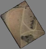
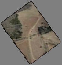
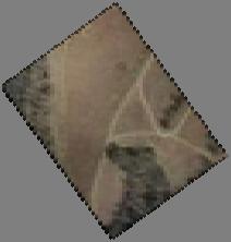
2 Introduction: Need Application 1 Monitoring Gully Erosion Field Erosion Progression Source: H. Hahn McPherson County


 Source: H.")
3 Introduction: Need Application 1 Monitoring Gully Erosion Manual transects performed using GPS (x,y) and laser level (z) Source: H. Hahn McPherson County

 require")

4 Introduction: Need Application 1 Monitoring Gully Erosion Manual transects (~15) require one day each major rainfall Source: H. Hahn McPherson County

5 Introduction: Need Application 1 Monitoring Gully Erosion Terrain Modeling Needs Reduce time to perform transect measurements Preserve a photographic and 3D model record for periodic field monitoring Estimate the volume of erosion taking place Integrate the 3D model in a GIS environment to correlate with soil, slope, and drainage patterns Source: H. Hahn McPherson County

6 Introduction: Need Application 2 Micro Drainage Modeling Residential neighborhood being threatened by eroding creek Source: D. Cross Kansas State University

7 Introduction: Need Application 2 Micro Drainage Modeling Analyzing drainage patterns between structures Source: D. Cross Kansas State University

8 Introduction: Need Application 2 Micro Drainage Modeling Proposed water treatment chains and detention areas Source: D. Cross Kansas State University
9 Introduction: Need Application 2 Micro Drainage Modeling Terrain Modeling Needs Terrain map post construction sites for design of stormwater best management practices (BMPs) Schedule flexibility to fly anytime, anywhere (not currently possible without COA) Aerial photo acquisition for small area sites where it is not cost effective to fly LiDAR Map drainage networks at potentially higher resolution than what is available through county 2m LiDAR data
10 Introduction: Tools (High End) Current Automated Techniques Aerial LiDAR platforms Typical Specifications Lateral placement accuracy: cm Vertical placement accuracy: 7 16 cm Filter first returns for bare earth results Platforms: Plane or helicopter Examples: Leica ALS70 cm /lidar.html
: 5 25 cm Examples: Leica ADS80, Aerometrex UltraCam http://commons. wikimedia.")
11 Introduction: Tools (High End) Current Automated Techniques Digital Photogrammetry Typical Specifications Optical/sensor: DTM and ortho from same source RGB color, color infrared, & panchromatic On the fly L1 image rectification Triangulation for DTM: Vert +/ 8 cm; contour 15 cm Ground sample distance (GSD): 5 25 cm Examples: Leica ADS80, Aerometrex UltraCam wikimedia.org/wiki/file:geo Referenced_Point_Cloud.JPG

12 Introduction: Tools (High End) Current Automated Techniques Terrestrial LiDAR Typical Specifications Range: 120 m Target acquisition: up to 50 m Point resolution: 3 mm at 50 m Speed: 1 million pps Examples: Leica ScanStation P20 Commons.wikimedia.org/wiki/file: Lidar_P


13 Introduction: Simpler options Goals Relatively low cost Rapid and easy field operation Sub dm accuracy


14 Software Selection Agisoft PhotoScan Pro Principle Photogrammetric bundle triangulation


15 Software Selection Agisoft PhotoScan Pro Applications Generation of digital elevation models & orthophotos 3D Point Cloud 3D Triangulation Ortho Mosaic Source data by Dr. K. Price Agisoft Model by H. Hahn


16 Software Selection Agisoft PhotoScan Pro Applications Area & volume measurements Stockpile Displacements sample04/sample05.pdf Mining Excavations sample04/sample04.pdf


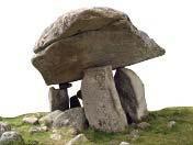
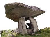
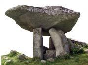
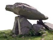
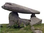
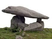
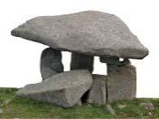

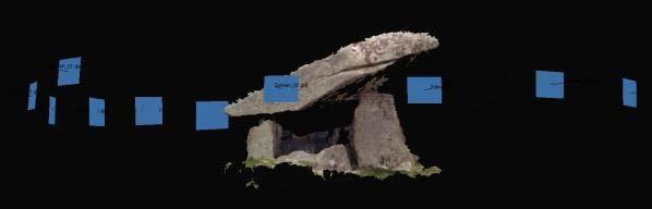
17 Software Selection Agisoft PhotoScan Pro Applications 3D model reconstruction (archaeology, etc.) Adapted from /kilclooney dolmen/ Kilclooney Dolmen (Scotland) 3D texture mapped model Agisoft model by H. Hahn


18 Photo Collection Terrestrial Standard 35 mm DSLR (Nikon D50) Photographic parameters Camera calibration derived from extracted digital photo info (FOV, FL, etc.) Recommended 5 megapixel or higher Move camera position 60% side overlap; 80% lateral overlap50 80% At least two scale markers Maintain angle to subject
 Unmanned Aerial")

19 Photography Collection Airborne Systems In the USA, subject to regulation by the Federal Aviation Administration and requires Certificate of Operation (COA) Unmanned Aerial Systems (UAS) standards by 2015 Camera: Lightweight Canon Powershot S100 (wide angle) RiteWing RC Zephyr Flying Wing UAS vehicles and photos by Dr. Kevin Price, KSU DJI S800 Hexacopter

20 Methods Test Site #1 Open Field Purpose: To determine if drainage patterns could be modeled in sufficient detail to replace LiDAR COA certificate Platform: Zephyr wing Images used: 9 Area: ~ 12.9 ha Cover: short grass Ground control: 2m LiDAR and Bing Imagery 16 pts


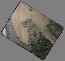
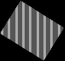
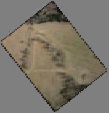

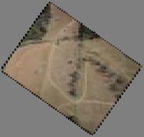

21 Methods Flight path and composite photo match


22 Results Test Site #1 Open Field Traditional LiDAR yields superior results Open Field Open Field Road trace Defined drainages Control point.(typ) 2m LiDAR Leafless tree patch (typ) Evergreen tree patch (typ) Agisoft PhotoScan 3D Model Inadequate photos per flight speed No bare earth processing (affected by vegetation)

23 Methods Test Site #2 Prairie Gully Purpose: To test if very low altitude aerial imagery/ photomodeling can replace manual transect techniques COA certificate Platform: DJI Hexacopter Images used: 16 Area: ~ 800 m 2 Cover: grass/dirt Ground control: 2m LiDAR and Bing Imagery 3 pts

24 Methods DJI Hexacopter Flight Path


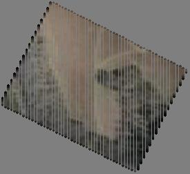
25 Methods 3D Point Cloud Triangulated surface model Texture mapped 3D model

26 Results Test Site #2 Prairie Gully Overall accuracy within 3 cm

27 Methods Test Site #3 Eroded Slope Purpose: To test if Agisoft could resolve minute surface differences enabling erosion volume calculations Handheld camera Images used: 9 Area: ~ 6.7 m 2 Cover: dirt Ground control: 2 markers


28 Methods 3D Point Cloud Triangulated surface model Texture mapped 3D model

29 Results Test Site #3 Eroded Slope Error Control Photographed surface x 2 Photo Series & Surface #1 Photo Series & Surface #2 Change detection noise

30 Results Test Site #3 Eroded Slope Error Control Photographed surface x 2 Photo Series & Surface #1 Scraped Surface Change detection noise
31 Conclusions TS 1 Field Matched GIS control points within +/ 1.5 m Terrain produced via Zephyr flying wing and PhotoScan did not yield better results than 2m LiDAR Too few photos acquired due to long photo interval relative flight speed (~ 60 km/hr) contributed to lower quality Vegetation, which could not be filtered from point cloud, contributed to lower quality compared to LiDAR results TS 2 Prairie Gully Imagery acquired from hexacopter flying at low 16m altitude used to generate 3D terrain model with a mean error of 3.53 cm compared against manual measurements
32 Conclusions TS 3 Eroded Slope At close photo ranges, PhotoScan is capable of resolving minute terrain changes (+/ 5 mm) For a small area test, Initial investigations demonstrated that accuracy of at least 85% can be achieved when estimating erosion quantities. Future Research Re test drainage network mapping for improved accuracy. For smaller fields, switch to a hexacopter aerial platform at slower flight speed. Attempt to filter vegetation from point clouds Create field gully models over an extended monitoring period, align models, and estimate erosion quantities
EVOLUTION OF POINT CLOUD
 Figure 1: Left and right images of a stereo pair and the disparity map (right) showing the differences of each pixel in the right and left image. (source: https://stackoverflow.com/questions/17607312/difference-between-disparity-map-and-disparity-image-in-stereo-matching)
2/9/2016. Session Agenda: Implementing new Geospatial Technologies for more efficient data capture
 Implementing new Geospatial Technologies for more efficient data capture Jay Haskamp Applied Geospatial Engineer Steve Richter VP Sales Session Agenda: Today s changing technologies and what lies ahead
LIDAR MAPPING FACT SHEET
 1. LIDAR THEORY What is lidar? Lidar is an acronym for light detection and ranging. In the mapping industry, this term is used to describe an airborne laser profiling system that produces location and
Journal Online Jaringan COT POLIPD (JOJAPS) Accuracy Assessment of Height Coordinate Using Unmanned Aerial Vehicle Images Based On Leveling Height
 Accuracy Assessment of Height Coordinate Using Unmanned Aerial Vehicle Images Based On Leveling Height") JOJAPS eissn 2504-8457 Abstract Journal Online Jaringan COT POLIPD (JOJAPS) Accuracy Assessment of Height Coordinate Using Unmanned Aerial Vehicle Images Based On Leveling Height Syamsul Anuar Bin Abu
JOJAPS eissn 2504-8457 Abstract Journal Online Jaringan COT POLIPD (JOJAPS) Accuracy Assessment of Height Coordinate Using Unmanned Aerial Vehicle Images Based On Leveling Height Syamsul Anuar Bin Abu
Terrestrial GPS setup Fundamentals of Airborne LiDAR Systems, Collection and Calibration. JAMIE YOUNG Senior Manager LiDAR Solutions
 Terrestrial GPS setup Fundamentals of Airborne LiDAR Systems, Collection and Calibration JAMIE YOUNG Senior Manager LiDAR Solutions Topics Terrestrial GPS reference Planning and Collection Considerations
An Introduction to Lidar & Forestry May 2013
 An Introduction to Lidar & Forestry May 2013 Introduction to Lidar & Forestry Lidar technology Derivatives from point clouds Applied to forestry Publish & Share Futures Lidar Light Detection And Ranging
Unmanned Aerial Systems: A Look Into UAS at ODOT
 Ohio Department of Transportation John R. Kasich, Governor Jerry Wray, Director Unmanned Aerial Systems: Tim Burkholder, PS Mapping Manager Division of Engineering Office of CADD and Mapping Services Kyle
Technical Considerations and Best Practices in Imagery and LiDAR Project Procurement
 Technical Considerations and Best Practices in Imagery and LiDAR Project Procurement Presented to the 2014 WV GIS Conference By Brad Arshat, CP, EIT Date: June 4, 2014 Project Accuracy A critical decision
PhotoScan. Fully automated professional photogrammetric kit
 PhotoScan Fully automated professional photogrammetric kit Agisoft PhotoScan is a stand-alone photogrammetric software solution for automatic generation of dense point clouds, textured polygonal models,
Intelligent photogrammetry. Agisoft
 Intelligent photogrammetry Agisoft Agisoft Metashape is a cutting edge software solution, with its engine core driving photogrammetry to its ultimate limits, while the whole system is designed to deliver
Photogrammetry: DTM Extraction & Editing
 Photogrammetry: DTM Extraction & Editing How can one determine the x, y, and z of a location? Approaches to DTM Extraction Ground surveying Digitized topographic maps Traditional photogrammetry Hardcopy
High resolution survey and orthophoto project of the Dosso-Gaya region in the Republic of Niger. by Tim Leary, Woolpert Inc.
 High resolution survey and orthophoto project of the Dosso-Gaya region in the Republic of Niger by Tim Leary, Woolpert Inc. Geospatial Solutions Photogrammetry & Remote Sensing LiDAR Professional Surveying
UAV s in Surveying: Integration/processes/deliverables A-Z. 3Dsurvey.si
 UAV s in Surveying: Integration/processes/deliverables A-Z Info@eGPS.net TODAY S PROGRAM Introduction to photogrammetry and 3Dsurvey Theoretical facts about the technology and basics of 3dsurvey Introduction
Sasanka Madawalagama Geoinformatics Center Asian Institute of Technology Thailand
 Sasanka Madawalagama Geoinformatics Center Asian Institute of Technology Thailand This learning material was not prepared by ADB. The views expressed in this document are the views of the author/s and
a Geo-Odyssey of UAS LiDAR Mapping Henno Morkel UAS Segment Specialist DroneCon 17 May 2018
 a Geo-Odyssey of UAS LiDAR Mapping Henno Morkel UAS Segment Specialist DroneCon 17 May 2018 Abbreviations UAS Unmanned Aerial Systems LiDAR Light Detection and Ranging UAV Unmanned Aerial Vehicle RTK Real-time
Trimble Geospatial Division Integrated Solutions for Geomatics professions. Volker Zirn Regional Sales Representative
 Trimble Geospatial Division Integrated Solutions for Geomatics professions Volker Zirn Regional Sales Representative 1 Agenda Trimble GeoSpatial Division Airborne System Solutions Trimble Inpho Software
Commercial suas The Right Tool for the Right Job
 Commercial suas The Right Tool for the Right Job Presentation Objectives Overview of current data collection technologies UAS Systems Overview Surveyor 2.0 Project Case Study Mobile LiDAR & suas How Do
Drone2Map: an Introduction. October 2017
 Drone2Map: an Introduction October 2017 Drone2Map: An Introduction Topics: - Introduction to Drone Mapping - Coordinate Systems - Overview of Drone2Map - Basic Drone2Map Workflow - 2D Data Processing -
Merging LiDAR Data with Softcopy Photogrammetry Data
 Merging LiDAR Data with Softcopy Photogrammetry Data Cindy McCallum WisDOT\Bureau of Technical Services Surveying & Mapping Section Photogrammetry Unit Overview Terms and processes Why use data from LiDAR
UAS for Surveyors. An emerging technology for the Geospatial Industry. Ian Murgatroyd : Technical Sales Rep. Trimble
 UAS for Surveyors An emerging technology for the Geospatial Industry Ian Murgatroyd : Technical Sales Rep. Trimble Project Overview Voyager Quarry, located near Perth Australia Typical of hard rock mines,
ALS40 Airborne Laser Scanner
 ALS40 Airborne Laser Scanner Airborne LIDAR for Professionals High Performance Laser Scanning Direct Measurement of Ground Surface from the Air The ALS40 Airborne Laser Scanner measures the topography
Overview of the Trimble TX5 Laser Scanner
 Overview of the Trimble TX5 Laser Scanner Trimble TX5 Revolutionary and versatile scanning solution Compact / Lightweight Efficient Economical Ease of Use Small and Compact Smallest and most compact 3D
Assessing 3D Point Cloud Fidelity of UAS SfM Software Solutions Over Varying Terrain
 Assessing 3D Point Cloud Fidelity of UAS SfM Software Solutions Over Varying Terrain Michael Schwind, Michael J. Starek (Presenter) 18th Annual JALBTCX Airborne Coastal Mapping and Charting Technical Workshop,
Course Outline (1) #6 Data Acquisition for Built Environment. Fumio YAMAZAKI
 #6 Data Acquisition for Built Environment. Fumio YAMAZAKI") AT09.98 Applied GIS and Remote Sensing for Disaster Mitigation #6 Data Acquisition for Built Environment 9 October, 2002 Fumio YAMAZAKI yamazaki@ait.ac.th http://www.star.ait.ac.th/~yamazaki/ Course Outline
AT09.98 Applied GIS and Remote Sensing for Disaster Mitigation #6 Data Acquisition for Built Environment 9 October, 2002 Fumio YAMAZAKI yamazaki@ait.ac.th http://www.star.ait.ac.th/~yamazaki/ Course Outline
TRIMBLE BUSINESS CENTER PHOTOGRAMMETRY MODULE
 TRIMBLE BUSINESS CENTER PHOTOGRAMMETRY MODULE WHITE PAPER TRIMBLE GEOSPATIAL DIVISION WESTMINSTER, COLORADO, USA July 2013 ABSTRACT The newly released Trimble Business Center Photogrammetry Module is compatible
PhotoScan. Fully automated professional photogrammetric kit
 PhotoScan Fully automated professional photogrammetric kit Agisoft PhotoScan is a stand-alone photogrammetric software solution for automatic generation of dense point clouds, textured polygonal models,
Light Detection and Ranging (LiDAR)
") Light Detection and Ranging (LiDAR) http://code.google.com/creative/radiohead/ Types of aerial sensors passive active 1 Active sensors for mapping terrain Radar transmits microwaves in pulses determines
Light Detection and Ranging (LiDAR) http://code.google.com/creative/radiohead/ Types of aerial sensors passive active 1 Active sensors for mapping terrain Radar transmits microwaves in pulses determines
2010 LiDAR Project. GIS User Group Meeting June 30, 2010
 2010 LiDAR Project GIS User Group Meeting June 30, 2010 LiDAR = Light Detection and Ranging Technology that utilizes lasers to determine the distance to an object or surface Measures the time delay between
MONITORING COASTAL INSTABILITY USING AIRBORNE AND TERRESTRIAL LIDAR
 MONITORING COASTAL INSTABILITY USING AIRBORNE AND TERRESTRIAL LIDAR A Coastal Challenge Monitoring coastlines is a challenging task, especially due to the typically inaccessible nature of the coastal terrain.
Low-Cost Orthophoto Production Using OrthoMapper Software
 Low-Cost Orthophoto Production Using OrthoMapper Software Rick Day Penn State Cooperative Extension, Geospatial Technology Program, RGIS-Chesapeake Air Photos Historical air photos are available from a
Drone2Map for ArcGIS: Bring Drone Imagery into ArcGIS. Will
 Drone2Map for ArcGIS: Bring Drone Imagery into ArcGIS Will Meyers @MeyersMaps A New Window on the World Personal Mapping for Micro-Geographies Accurate High Quality Simple Low-Cost Drone2Map for ArcGIS
THREE DIMENSIONAL CURVE HALL RECONSTRUCTION USING SEMI-AUTOMATIC UAV
 THREE DIMENSIONAL CURVE HALL RECONSTRUCTION USING SEMI-AUTOMATIC UAV Muhammad Norazam Zulgafli 1 and Khairul Nizam Tahar 1,2 1 Centre of Studies for Surveying Science and Geomatics, Faculty of Architecture
Terrain Modeling and Mapping for Telecom Network Installation Using Scanning Technology. Maziana Muhamad
 Terrain Modeling and Mapping for Telecom Network Installation Using Scanning Technology Maziana Muhamad Summarising LiDAR (Airborne Laser Scanning) LiDAR is a reliable survey technique, capable of: acquiring
Photogrammetry for forest inventory.
 Photogrammetry for forest inventory. Marc Pierrot Deseilligny. IGN/ENSG, France. Jonathan Lisein. Ulg Gembloux Agro-Bio Tech, Belgium. 1- Photogrammetry 2- Application to forestry 3- Tools and proposed
Surveying like never before
 CAD functionalities GCP Mapping and Aerial Image Processing Software for Land Surveying Specialists Surveying like never before www.3dsurvey.si Modri Planet d.o.o., Distributors: info@3dsurvey.si +386
Todd King, PLS, LEED AP Business Developer
 Todd King, PLS, LEED AP Business Developer TKing@McKimCreed.com 38 YEARS 378 EMPLOYEES ENR Top 500 Design Firm ENR Top 200 Environmental ENR Southeast Engineer Firms POB Geospatial Top 100 Top 50 Trenchless
Hamilton County Enhances GIS Base Mapping with 1-foot Contours
 Hamilton County Enhances GIS Base Mapping with 1-foot Contours Presented by Larry Stout, Hamilton County GIS Manager Brad Fugate, Woolpert Inc. Today s Presentation Hamilton County s 2004 Base Mapping
UAS Campus Survey Project
 ARTICLE STUDENTS CAPTURING SPATIAL INFORMATION NEEDS UAS Campus Survey Project Texas A&M University- Corpus Christi, home to the largest geomatics undergraduate programme in Texas, USA, is currently undergoing
USING UNMANNED AERIAL VEHICLE (DRONE/FLYCAM) TECHNOLOGY IN SURVEY WORK OF PORTCOAST
 TECHNOLOGY IN SURVEY WORK OF PORTCOAST") USING UNMANNED AERIAL VEHICLE (DRONE/FLYCAM) TECHNOLOGY IN SURVEY WORK OF PORTCOAST 1. Capturing aerial images by using Drone Taking images by drones is currently applied in many fields especially in topographic
USING UNMANNED AERIAL VEHICLE (DRONE/FLYCAM) TECHNOLOGY IN SURVEY WORK OF PORTCOAST 1. Capturing aerial images by using Drone Taking images by drones is currently applied in many fields especially in topographic
MODERNIZING THE MODEL FOR STREAMBANK, WATERSHED, STORMWATER MANAGEMENT, AND FLOODPLAIN PLANNING AND RESTORATION
 MODERNIZING THE MODEL FOR STREAMBANK, WATERSHED, STORMWATER MANAGEMENT, AND FLOODPLAIN PLANNING AND RESTORATION April M. Barkasi, PE, CEO, CEDARVILLE Engineering Group LLC, Pottstown, PA PURPOSE The purpose
N.J.P.L.S. An Introduction to LiDAR Concepts and Applications
 N.J.P.L.S. An Introduction to LiDAR Concepts and Applications Presentation Outline LIDAR Data Capture Advantages of Lidar Technology Basics Intensity and Multiple Returns Lidar Accuracy Airborne Laser
Ingesting, Managing, and Using UAV (Drone) Imagery in the ArcGIS Platform
 Imagery in the ArcGIS Platform") Ingesting, Managing, and Using UAV (Drone) Imagery in the ArcGIS Platform Cody A. Benkelman Technical Product Manager Imagery Esri cbenkelman@esri.com Version 2 17 November 2015 This in an Esri draft document
Ingesting, Managing, and Using UAV (Drone) Imagery in the ArcGIS Platform Cody A. Benkelman Technical Product Manager Imagery Esri cbenkelman@esri.com Version 2 17 November 2015 This in an Esri draft document
Open Pit Mines. Terrestrial LiDAR and UAV Aerial Triangulation for. Figure 1: ILRIS at work
 Terrestrial LiDAR and UAV Aerial Triangulation for Open Pit Mines Figure 1: ILRIS at work Figure 2: Geo-Copter X-8000 taking off ay what you will about the past few years, it has produced some useful tools
Mayden VP of Business Development Surdex Corporation
 Making Sense of Sensors Randy Mayden, Mayden VP of Business Development Surdex Corporation randym@surdex.com EARLYAERIAL PHOTOGRAPHY 2 FIRSTAERIAL CAMERA 3 AERIAL CAMERA SYSTEM DEVELOPMENT Aerial Camera
UAS to GIS Utilizing a low-cost Unmanned Aerial System (UAS) for Coastal Erosion Monitoring
 for Coastal Erosion Monitoring") UAS to GIS Utilizing a low-cost Unmanned Aerial System (UAS) for Coastal Erosion Monitoring A New Window on the World Personal Mapping for Micro-Geographies Accurate High Quality Simple Low-Cost Drone2Map
UAS to GIS Utilizing a low-cost Unmanned Aerial System (UAS) for Coastal Erosion Monitoring A New Window on the World Personal Mapping for Micro-Geographies Accurate High Quality Simple Low-Cost Drone2Map
TopoDrone Photogrammetric Mapping Reliable, Accurate, Safe
 TopoDrone Photogrammetric Mapping Reliable, Accurate, Safe A complete solution for accurate airborne data capture and photogrammetric mapping using an unmanned aerial vehicle COST EFFICIENT SOLUTION TO
Leica Systems Overview
 RC30 AERIAL CAMERA SYSTEM Leica Systems Overview The Leica RC30 aerial film camera is the culmination of decades of development, started with Wild's first aerial camera in the 1920s. Beautifully engineered
3D recording of archaeological excavation
 5 th International Conference Remote Sensing in Archaeology The Age of Sensing 13-15 October 2014 - Duke University 3D recording of archaeological excavation Stefano Campana UNIVERSITY of CAMBRIDGE Faculty
Aerial and Mobile LiDAR Data Fusion
 Creating Value Delivering Solutions Aerial and Mobile LiDAR Data Fusion Dr. Srini Dharmapuri, CP, PMP What You Will Learn About LiDAR Fusion Mobile and Aerial LiDAR Technology Components & Parameters Project
Feature Extraction from Imagery & Lidar. Kurt Schwoppe, Esri Mark Romero, Esri Gregory Bacon, Fairfax County
 Feature Extraction from & Lidar Kurt Schwoppe, Esri Mark Romero, Esri Gregory Bacon, Fairfax County Today s Speakers Image Processing Experts and Good Colleagues Kurt Schwoppe Industry Lead Esri Mark Romero
Photogrammetric Performance of an Ultra Light Weight Swinglet UAV
 Photogrammetric Performance of an Ultra Light Weight Swinglet UAV J. Vallet, F. Panissod, C. Strecha, M. Tracol UAV-g 2011 - Unmanned Aerial Vehicle in Geomatics September 14-16, 2011ETH Zurich Summary
SimActive and PhaseOne Workflow case study. By François Riendeau and Dr. Yuri Raizman Revision 1.0
 SimActive and PhaseOne Workflow case study By François Riendeau and Dr. Yuri Raizman Revision 1.0 Contents 1. Introduction... 2 1.1. Simactive... 2 1.2. PhaseOne Industrial... 2 2. Testing Procedure...
2. POINT CLOUD DATA PROCESSING
 Point Cloud Generation from suas-mounted iphone Imagery: Performance Analysis A. D. Ladai, J. Miller Towill, Inc., 2300 Clayton Road, Suite 1200, Concord, CA 94520-2176, USA - (andras.ladai, jeffrey.miller)@towill.com
Geomatica OrthoEngine Orthorectifying VEXCEL UltraCam Data
 Geomatica OrthoEngine Orthorectifying VEXCEL UltraCam Data Vexcel s UltraCam digital camera system has a focal distance of approximately 100mm and offers a base panchromatic (black and white) resolution
Quality Accuracy Professionalism
 GeoWing - who are we? Mapping Data Service Provider Lidar Multispectral Topographic and Planimetric Maps Elevation Models Point Clouds / 3D Models Orthophotography FAA-Authorized UAS Operators WOSB / DBE
Drones for research - Observing the world in 3D from a LiDAR-UAV
 Drones for research - Observing the world in 3D from a LiDAR-UAV Program lunch seminar: Lammert Kooistra: The Unmanned Aerial Remote Sensing Facility goes 3D: Unmanned Aerial Laser Scanning Sander Mücher:
Lidar Sensors, Today & Tomorrow. Christian Sevcik RIEGL Laser Measurement Systems
 Lidar Sensors, Today & Tomorrow Christian Sevcik RIEGL Laser Measurement Systems o o o o Online Waveform technology Stand alone operation no field computer required Remote control through wireless network
Mobile LiDAR for Ground Applications. Spar 2006, March Paul Mrstik, Terrapoint Canada Inc. Craig Glennie, Terrapoint USA LLC
 Mobile LiDAR for Ground Applications Spar 2006, March 27 2006 Paul Mrstik, Terrapoint Canada Inc. Craig Glennie, Terrapoint USA LLC Agenda Introduction to Terrapoint What is mobile LiDAR? Advantages of
trimble unmanned aircraft systems
 trimble unmanned aircraft systems FOR SURVEYING and MAPPING TRIMBLE UAS AERIAL IMAGING solution: INDUSTRY-LEADING UAS MAPPING SOLUTIONS FOR ALL YOUR APPLICATION NEEDS Trimble prides itself on being a leader
Coastal Survey of archaeological sites using drones
 Coastal Survey of archaeological sites using drones In Poseidon s Realm XXI Underwater archaeology - interdisciplinary approaches and technical innovations Dimitrios Skarlatos, Savvidou Eleni Photogrammetric
The raycloud A Vision Beyond the Point Cloud
 The raycloud A Vision Beyond the Point Cloud Christoph STRECHA, Switzerland Key words: Photogrammetry, Aerial triangulation, Multi-view stereo, 3D vectorisation, Bundle Block Adjustment SUMMARY Measuring
USE OF DRONE TECHNOLOGY AND PHOTOGRAMMETRY FOR BEACH MORPHODYNAMICS AND BREAKWATER MONITORING.
 Proceedings of the 6 th International Conference on the Application of Physical Modelling in Coastal and Port Engineering and Science (Coastlab16) Ottawa, Canada, May 10-13, 2016 Copyright : Creative Commons
Integrated Multi-Source LiDAR and Imagery
 Figure 1: AirDaC aerial scanning system Integrated Multi-Source LiDAR and Imagery The derived benefits of LiDAR scanning in the fields of engineering, surveying, and planning are well documented. It has
SPAR, ELMF 2013, Amsterdam. Laser Scanning on the UK Highways Agency Network. Hamish Grierson Blom Uk
 SPAR, ELMF 2013, Amsterdam Laser Scanning on the UK Highways Agency Network Hamish Grierson Blom Uk www.blomasa.com www.blom-uk.co.uk Blom UK Part of the Blom Group Blom Group - Europe s largest aerial
LIDAR 101 & 2014 MO/AR LIDAR PARTNERS PROJECT. NEMO GIS Workshop
 LIDAR 101 & 2014 MO/AR LIDAR PARTNERS PROJECT NEMO GIS Workshop May 22, 2014 PRESENTER Tim Donze Business Development Surdex Corporation PRESENTATION TOPICS What is LiDAR? Why is LiDAR Valuable? Missouri
Innovative Applications of Drone Technology in the Engineering of Large Dams
 Innovative Applications of Drone Technology in the Engineering of Large Dams Giorgio Pietrangeli Giuseppe Pittalis Vincenzo Millesi Riccardo Cifra Studio Ing. G. Pietrangeli Srl Via Cicerone 28 00193 Rome
Reality Modeling Drone Capture Guide
 Reality Modeling Drone Capture Guide Discover the best practices for photo acquisition-leveraging drones to create 3D reality models with ContextCapture, Bentley s reality modeling software. Learn the
Photogrammetry: A Modern Tool for Crash Scene Mapping
 Photogrammetry: A Modern Tool for Crash Scene Mapping Background A police accident investigator (AI) has many tasks when arriving at a crash scene. The officer s highest priority is public safety; the
Efficient Processing of UAV Projects
 Efficient Processing of UAV Projects Dr. Philippe Simard President SimActive Inc. IMAGE About SimActive Leading developer of photogrammetry software since 2003 Thousands of users in 50+ countries: military
Remote Sensing Sensor Integration
 Remote Sensing Sensor Integration Erica Tharp LiDAR Supervisor Table of Contents About 3001 International Inc Remote Sensing Platforms Why Sensor Integration? Technical Aspects of Sensor Integration Limitations
STARTING WITH DRONES. Data Collection and Remote Sensing with UAVs, etc. Dr. Bill Hazelton LS
 STARTING WITH DRONES Data Collection and Remote Sensing with UAVs, etc. Dr. Bill Hazelton LS What this Talk is About UAV-based data acquisition: What you need to get involved Processes in getting spatial
International Journal of Civil Engineering and Geo-Environment. Close-Range Photogrammetry For Landslide Monitoring
 International Journal of Civil Engineering and Geo-Environment Journal homepage:http://ijceg.ump.edu.my ISSN:21802742 Close-Range Photogrammetry For Landslide Monitoring Munirah Bt Radin Mohd Mokhtar,
DEVELOPING METHODOLOGY TO MAP TREE CANOPY IN URBAN AREAS FROM LOW COST COMMERCIAL UAVS
 DEVELOPING METHODOLOGY TO MAP TREE CANOPY IN URBAN AREAS FROM LOW COST COMMERCIAL UAVS Niluka Munasinghe 1, U.I. Manatunga 1, H.M.R. Premasiri 1, N. Lakmal Deshapriya 2, S.L. Madawalagama 2 and Lal Samarakoon
Classification of urban feature from unmanned aerial vehicle images using GASVM integration and multi-scale segmentation
 Classification of urban feature from unmanned aerial vehicle images using GASVM integration and multi-scale segmentation M.Modiri, A.Salehabadi, M.Mohebbi, A.M.Hashemi, M.Masumi National Geographical Organization
Leica - Airborne Digital Sensors (ADS80, ALS60) Update / News in the context of Remote Sensing applications
 Update / News in the context of Remote Sensing applications") Luzern, Switzerland, acquired with GSD=5 cm, 2008. Leica - Airborne Digital Sensors (ADS80, ALS60) Update / News in the context of Remote Sensing applications Arthur Rohrbach, Sensor Sales Dir Europe,
Luzern, Switzerland, acquired with GSD=5 cm, 2008. Leica - Airborne Digital Sensors (ADS80, ALS60) Update / News in the context of Remote Sensing applications Arthur Rohrbach, Sensor Sales Dir Europe,
REMOTE SENSING LiDAR & PHOTOGRAMMETRY 19 May 2017
 REMOTE SENSING LiDAR & PHOTOGRAMMETRY 19 May 2017 SERVICES Visual Inspections Digital Terrain Models Aerial Imagery Volume Computations Thermal Inspections Photo maps Aerial Video Training & Consultancy
INTRODUCTION TO Accelerating Data Collection with Unmanned Aircraft Systems
 INTRODUCTION TO Accelerating Data Collection with Unmanned Aircraft Systems Kyle Kukuk Terry Pallotto MWCC Enviromental Conference July 10-12, 2016 Who is Here? Kyle Kukuk, PE Project Manager Blackstone
Harnessing GIS and Imagery for Power Transmission Inspection. ESRI European Users Conference October 15, 2015
 Harnessing GIS and Imagery for Power Transmission Inspection ESRI European Users Conference October 15, 2015 About Us Airborne/Threod Designer, manufacturer & service provider for multi-rotor & fixed wing
Assessing the Accuracy of Stockpile Volumes Obtained Through Aerial Surveying
 CASE STUDY Assessing the Accuracy of Stockpile Volumes Obtained Through Aerial Surveying Martin Remote Sensing share surveying insight DroneDeploy Introduction This report comes to us from Kelsey Martin,
EXTRACTION OF URBAN PARAMETERS FROM 3D POINT-CLOUD WITHIN GRASS
 VII JORNADAS DE SIG LIBRE EXTRACTION OF URBAN PARAMETERS FROM 3D POINT-CLOUD WITHIN GRASS C.REBELO, A. M. RODRIGUES, B.NEVES, J.A. TENEDÓRIO, and J.A. GONÇALVES http://creativecommons.org/licenses/by-nc-sa/3.0/
Corridor Survey of Both Existing and New to be Built Pipelines on Land Using LiDAR Scanning
 Corridor Survey of Both Existing and New to be Built Pipelines on Land Using LiDAR Scanning 1. Introduction For good monitoring and planning an onshore pipeline and to feed the Geographic Information System,
Chapters 1 7: Overview
 Chapters 1 7: Overview Photogrammetric mapping: introduction, applications, and tools GNSS/INS-assisted photogrammetric and LiDAR mapping LiDAR mapping: principles, applications, mathematical model, and
Geometry of Aerial photogrammetry. Panu Srestasathiern, PhD. Researcher Geo-Informatics and Space Technology Development Agency (Public Organization)
") Geometry of Aerial photogrammetry Panu Srestasathiern, PhD. Researcher Geo-Informatics and Space Technology Development Agency (Public Organization) Image formation - Recap The geometry of imaging system
Geometry of Aerial photogrammetry Panu Srestasathiern, PhD. Researcher Geo-Informatics and Space Technology Development Agency (Public Organization) Image formation - Recap The geometry of imaging system
Airborne Sensor Technology
 Airborne Sensor Technology Arthur Rohrbach Airborne Sensor Manager EMEA Geospatial Solutions Division (GSD) 1 The World of Airborne Sensor Technology 2 Agenda Hexagon Geosystems Leica & Z/I airborne solutions
CLASSIFICATION OF NONPHOTOGRAPHIC REMOTE SENSORS
 CLASSIFICATION OF NONPHOTOGRAPHIC REMOTE SENSORS PASSIVE ACTIVE DIGITAL CAMERA THERMAL (e.g. TIMS) VIDEO CAMERA MULTI- SPECTRAL SCANNERS VISIBLE & NIR MICROWAVE HYPERSPECTRAL (e.g. AVIRIS) SLAR Real Aperture
LiDAR & Orthophoto Data Report
 LiDAR & Orthophoto Data Report Tofino Flood Plain Mapping Data collected and prepared for: District of Tofino, BC 121 3 rd Street Tofino, BC V0R 2Z0 Eagle Mapping Ltd. #201 2071 Kingsway Ave Port Coquitlam,
1. Introduction. A CASE STUDY Dense Image Matching Using Oblique Imagery Towards All-in- One Photogrammetry
 Submitted to GIM International FEATURE A CASE STUDY Dense Image Matching Using Oblique Imagery Towards All-in- One Photogrammetry Dieter Fritsch 1, Jens Kremer 2, Albrecht Grimm 2, Mathias Rothermel 1
Airborne and Mobile LiDAR for Transport Corridor Survey Dr. Bharat Lohani Director, Geokno India Pvt. Ltd. & Professor, Geoinformatics IIT Kanpur
 www.geokno.com Airborne and Mobile LiDAR for Transport Corridor Survey Dr. Bharat Lohani Director, Geokno India Pvt. Ltd. & Professor, Geoinformatics IIT Kanpur Geokno has executed and is executing multiple
Outline of Presentation. Introduction to Overwatch Geospatial Software Feature Analyst and LIDAR Analyst Software
 Outline of Presentation Automated Feature Extraction from Terrestrial and Airborne LIDAR Presented By: Stuart Blundell Overwatch Geospatial - VLS Ops Co-Author: David W. Opitz Overwatch Geospatial - VLS
Development of Unmanned Aircraft System (UAS) for Agricultural Applications. Quarterly Progress Report
 for Agricultural Applications. Quarterly Progress Report") Development of Unmanned Aircraft System (UAS) for Agricultural Applications Quarterly Progress Report Reporting Period: October December 2016 January 30, 2017 Prepared by: Lynn Fenstermaker and Jayson
Development of Unmanned Aircraft System (UAS) for Agricultural Applications Quarterly Progress Report Reporting Period: October December 2016 January 30, 2017 Prepared by: Lynn Fenstermaker and Jayson
Chapters 1-4: Summary
 Chapters 1-4: Summary So far, we have been investigating the image acquisition process. Chapter 1: General introduction Chapter 2: Radiation source and properties Chapter 3: Radiation interaction with
The Use and Applications of Unmanned- Aerial Systems (UAS) In Agriculture
 In Agriculture") The Use and Applications of Unmanned- Aerial Systems (UAS) In Agriculture R O B E R T A U S T I N, D E P A R T M E N T O F S O I L S C I E N C E N C S T A T E U N I V E R S I T Y DJI Inspire Photo Credit:
The Use and Applications of Unmanned- Aerial Systems (UAS) In Agriculture R O B E R T A U S T I N, D E P A R T M E N T O F S O I L S C I E N C E N C S T A T E U N I V E R S I T Y DJI Inspire Photo Credit:
Tutorial (Intermediate level): Dense Cloud Classification and DTM generation with Agisoft PhotoScan Pro 1.1
: Dense Cloud Classification and DTM generation with Agisoft PhotoScan Pro 1.1") Tutorial (Intermediate level): Dense Cloud Classification and DTM generation with Agisoft PhotoScan Pro 1.1 This tutorial illustrates how to perform dense point cloud classification in manual and automatic
Tutorial (Intermediate level): Dense Cloud Classification and DTM generation with Agisoft PhotoScan Pro 1.1 This tutorial illustrates how to perform dense point cloud classification in manual and automatic
Trends in Digital Aerial Acquisition Systems
 Trends in Digital Aerial Acquisition Systems Ernest Yap Regional Sales Manager, Airborne-Americas eyap@applanix.com 1 Medium Format Digital Cameras Medium Format Digital Cameras Where does the Medium
LiDAR data overview. Dr. Keiko Saito Global Facility for Disaster Reduction and Recovery (GFDRR)
") LiDAR data overview Dr. Keiko Saito Global Facility for Disaster Reduction and Recovery (GFDRR) LiDAR (Light Detecting And Ranging) 3D height profile Laser emitted from sensor onboard aircraft to measure
LiDAR data overview Dr. Keiko Saito Global Facility for Disaster Reduction and Recovery (GFDRR) LiDAR (Light Detecting And Ranging) 3D height profile Laser emitted from sensor onboard aircraft to measure
TAKING FLIGHT JULY/AUGUST 2015 COMMERCIAL UAS ADVANCEMENT BALLOONS THE POOR MAN S UAV? SINGLE PHOTON SENSOR REVIEW VOLUME 5 ISSUE 5
 VOLUME 5 ISSUE 5 JULY/AUGUST 2015 TAKING FLIGHT 14 COMMERCIAL UAS ADVANCEMENT 24 BALLOONS THE POOR MAN S UAV? 30 SINGLE PHOTON SENSOR REVIEW Closing in on 500 authorizations the FAA has expedited the exemption
2-4 April 2019 Taets Art and Event Park, Amsterdam CLICK TO KNOW MORE
 Co-Host Host 2-4 April 2019 Taets Art and Event Park, Amsterdam CLICK TO KNOW MORE Presentation Outline review modern survey methodologies available to support railway requirements measuring everything
Trimble GeoSpatial Products
 Expanding Solutions for Photogrammetric and Remote Sensing Professionals 55 th Photogrammetric Week in Stuttgart September 7 th 2015 Tobias Heuchel, Trimble Stuttgart, Germany Trimble GeoSpatial Products
Generating highly accurate 3D data using a sensefly exom drone
 Generating highly accurate 3D data using a sensefly exom drone C. Álvarez 1, A. Roze 2, A. Halter 3, L. Garcia 4 1 Geomatic Engineer, Lehmann Géomètre SA 2 Application Engineer, sensefly SA 3 Geomatic
The ArcGIS Platform for Managing, Processing, and Sharing UAV Data
 The ArcGIS Platform for Managing, Processing, and Sharing UAV Data Cody Benkelman, Technical Product Manager - Imagery David Gadsden, Nonprofit Program Manager Esri Advancing GIS Strong and Growing..Serving