Mobile LiDAR for Ground Applications. Spar 2006, March Paul Mrstik, Terrapoint Canada Inc. Craig Glennie, Terrapoint USA LLC
|
|
|
- Erin Jacobs
- 6 years ago
- Views:
Transcription


1 Mobile LiDAR for Ground Applications Spar 2006, March Paul Mrstik, Terrapoint Canada Inc. Craig Glennie, Terrapoint USA LLC
2 Agenda Introduction to Terrapoint What is mobile LiDAR? Advantages of going mobile Terrapoint s SideSwipe system Development Block Diagram Experience Future of Mobile LiDAR Technology Applications


3 Introduction to Terrapoint Offices in Houston, Calgary and Ottawa 20+ years of airborne mapping and survey experience 9+ years of LiDAR survey experience Projects in over 40 countries 50+ experts in Physics, Engineering, Geodetics and GIS 7 LiDAR systems: 3 low-altitude high accuracy, 3 high-altitude fixed-wing, 1 system for ground operations

4 Projects Overview Over 500 LiDAR projects from the air & from the ground Major Markets served:» Oil & Gas/Seismic» Transportation» Land Development» Powerline/Utilities» Mining» Environmental/Flood

5 Mobile LiDAR 1. The position of the laser is provided by GPS 2. The orientation of the laser is provided by an IMU 3. The scan angles and ranges of the laser are provided by the sensor data combined in post-flight processing to accurately determine the position of each point Data combination occurs post mission
6 Advantages of Going Mobile Advantages Speed of acquisition Area covered Safety Homogeneous segments unnecessary to align any clouds Disadvantages Accuracy Point density Access to some areas Shadowing Need accurate Navigation Solution

7 Low-Altitude LiDAR System LiDAR sensor, GPS & IMU all integrated in modular design Combined with high-resolution digital camera 10 KHz Laser, max 350 m AGL Portable/modular design Easy to install and operate Fly low and slow for high survey point density Millions of survey points per sq km 2 to 20 pts/sq m
8 Terrapoint s Sideswipe System 2002: Developed a prototype to test the concept of LiDAR on a ground vehicle Solution waiting for a problem for a few years Obstructions were a problem Multiple passes required for good coverage 2004: Requirement in Afghanistan to do a road survey Couldn t find a suitable helicopter Built prototype into a production prototype in about 1 month & tested it on home turf Successful test meant we could send it to Afghanistan Testing was done against ground truth as well as airborne LiDAR Fusing airborne and ground data sets was no problem


9 SideSwipe LIDAR Take conventional LiDAR Bring it down-to to-earth Turn it on its side


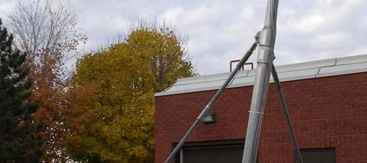
10 SideSwipe Assembly


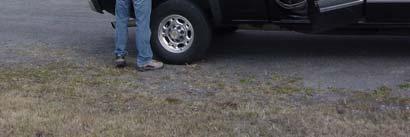
11 SideSwipe LIDAR Test System On the road in Afghanistan 40 survey points per sq m on the pavement


12 Flexible solution UK SideSwipe Switzerland low-range 1 week later same system

13 BoatDAR on Mooney s Bay Objectives Test viability of LIDAR mapping of shorelines. Determine whether or not water causes interference due to reflections etc. Net Result Very fast survey Ability to map under canopy along the shoreline Ability to map structural features from the water 5-10 cm accuracy possible


14 Determining the Accuracy Check airborne LiDAR against SideSwipe Multiple passes of SideSwipe compared to each other LiDAR is a great for checking the accuracy of the GPS/INS, and even the LiDAR itself it provides a long lever arm that amplifies errors Measurement runs in opposite directions provide checks on horizontal accuracy. GPS road profiles GPS spot checks Total station cross sections

15 Determining the Accuracy Centre Line Ditch Site Edge of Pavement Edge of Shoulder Guard Rail Property Line Toe Slope 100 m AGL: Sample 294 points RMSE 3.74 cm Sample Size RMSE 2.2 cm 3.7 cm 2.8 cm 4 cm 4.9 cm 4.8 cm 4.6 cm LiDAR hill-shade image with cross sections 10 pts / sq. m
 Vibration Limited field of view in")
16 SideSwipe Ups and Downs Pros: Cons: Accurate Fast Homgeneous data sets Lots of points Great for wires, clearances Difficult to process (software not designed for long corridors of side scans when you do vegetation removal) Vibration Limited field of view in one pass

17 Ground Based LIDAR Planimetric View ~1 km ~15 minutes of data collection

18 Boat LIDAR Planimetric Shoreline View ~1 km ~10 minutes of data collection
19 Future of Mobile LiDAR Technology GPS (new positioning systems more satellites) INS Longer Stability MEMS? Image coverage & improved LiDAR coverage Additional Sensors Compass & heading Odometer Replacement or enhancement of GPS using Images Triangulation LiDAR (tunnelling projects)
20 Future of Mobile LiDAR Applications Corridors (Engineering) Highways Railways Power lines Overpasses Urban areas Roads Infrastructure Communication and power wires Curbs Intersections Underground/Indoors Mines Malls? Subways
21 Questions? Paul Mrstik: (613) Craig Glennie: (281)
Aerial and Mobile LiDAR Data Fusion
 Creating Value Delivering Solutions Aerial and Mobile LiDAR Data Fusion Dr. Srini Dharmapuri, CP, PMP What You Will Learn About LiDAR Fusion Mobile and Aerial LiDAR Technology Components & Parameters Project
SPAR, ELMF 2013, Amsterdam. Laser Scanning on the UK Highways Agency Network. Hamish Grierson Blom Uk
 SPAR, ELMF 2013, Amsterdam Laser Scanning on the UK Highways Agency Network Hamish Grierson Blom Uk www.blomasa.com www.blom-uk.co.uk Blom UK Part of the Blom Group Blom Group - Europe s largest aerial
LIDAR MAPPING FACT SHEET
 1. LIDAR THEORY What is lidar? Lidar is an acronym for light detection and ranging. In the mapping industry, this term is used to describe an airborne laser profiling system that produces location and
2-4 April 2019 Taets Art and Event Park, Amsterdam CLICK TO KNOW MORE
 Co-Host Host 2-4 April 2019 Taets Art and Event Park, Amsterdam CLICK TO KNOW MORE Presentation Outline review modern survey methodologies available to support railway requirements measuring everything
Mobile Mapping The StreetMapper Approach. Andrew Fuller LiDAR Systems Engineer
 Mobile Mapping The StreetMapper Approach Andrew Fuller LiDAR Systems Engineer UK company based in Nottingham Global 3D Laser Mapping Solutions Innovative solutions StreetMapper Over 11 years experience
Integrated Multi-Source LiDAR and Imagery
 Figure 1: AirDaC aerial scanning system Integrated Multi-Source LiDAR and Imagery The derived benefits of LiDAR scanning in the fields of engineering, surveying, and planning are well documented. It has
AIRBORNE GEIGER MODE LIDAR - LATEST ADVANCEMENTS IN REMOTE SENSING APPLICATIONS RANDY RHOADS
 Place image here (10 x 3.5 ) AIRBORNE GEIGER MODE LIDAR - LATEST ADVANCEMENTS IN REMOTE SENSING APPLICATIONS RANDY RHOADS Geospatial Industry Manager HARRIS.COM #HARRISCORP Harris Company Information SECURITY
Federica Zampa Sineco SpA V. le Isonzo, 14/1, Milan, 20135, Italy
 LYNX MOBILE MAPPER TM : THE NEW SURVEY TECHNOLOGY Federica Zampa Sineco SpA V. le Isonzo, 14/1, Milan, 20135, Italy federica.zampa@sineco.co.it Dario Conforti Optech Incorporated 300 Interchange Way, Vaughan,
LiDAR data overview. Dr. Keiko Saito Global Facility for Disaster Reduction and Recovery (GFDRR)
") LiDAR data overview Dr. Keiko Saito Global Facility for Disaster Reduction and Recovery (GFDRR) LiDAR (Light Detecting And Ranging) 3D height profile Laser emitted from sensor onboard aircraft to measure
LiDAR data overview Dr. Keiko Saito Global Facility for Disaster Reduction and Recovery (GFDRR) LiDAR (Light Detecting And Ranging) 3D height profile Laser emitted from sensor onboard aircraft to measure
Using Mobile LiDAR To Efficiently Collect Roadway Asset and Condition Data. Pierre-Paul Grondin, B.Sc. Surveying
 Using Mobile LiDAR To Efficiently Collect Roadway Asset and Condition Data Pierre-Paul Grondin, B.Sc. Surveying LIDAR (Light Detection and Ranging) The prevalent method to determine distance to an object
Terrestrial GPS setup Fundamentals of Airborne LiDAR Systems, Collection and Calibration. JAMIE YOUNG Senior Manager LiDAR Solutions
 Terrestrial GPS setup Fundamentals of Airborne LiDAR Systems, Collection and Calibration JAMIE YOUNG Senior Manager LiDAR Solutions Topics Terrestrial GPS reference Planning and Collection Considerations
Trimble GeoSpatial Products
 Expanding Solutions for Photogrammetric and Remote Sensing Professionals 55 th Photogrammetric Week in Stuttgart September 7 th 2015 Tobias Heuchel, Trimble Stuttgart, Germany Trimble GeoSpatial Products
Lewis County Public Works Department (County) GIS Mapping Division 350 N. Market Blvd. Chehalis, WA Phone: Fax:
 GIS Mapping Division 350 N. Market Blvd. Chehalis, WA Phone: Fax:") March 31, 2005 Project Report Lewis County, WA Contract #2262-H Report Presented to: Lewis County Public Works Department (County) GIS Mapping Division 350 N. Market Blvd. Chehalis, WA 98532-2626 Phone:
March 31, 2005 Project Report Lewis County, WA Contract #2262-H Report Presented to: Lewis County Public Works Department (County) GIS Mapping Division 350 N. Market Blvd. Chehalis, WA 98532-2626 Phone:
THE RAILMAPPER - A DEDICATED MOBILE LIDAR MAPPING SYSTEM FOR RAILWAY NETWORKS
 THE RAILMAPPER - A DEDICATED MOBILE LIDAR MAPPING SYSTEM FOR RAILWAY NETWORKS Jens Kremer & Albrecht Grimm IGI mbh, Langenauer Straße 46, 57223 Kreuztal, Germany (j.kremer, a.grimm)@igi-systems.com ICWG
Mobile Mapping Solutions for Ohio s Integrated Transportation Network. Brian Foster, CP
 Mobile Mapping Solutions for Ohio s Integrated Transportation Network Brian Foster, CP About Woolpert Established in 1911 Over 600 Professionals 25 Offices $12,000,000 invested in new technology in last
Airborne LiDAR Surveys and Data Delivery in the Pipeline Industry
 Airborne LiDAR Surveys and Data Delivery in the Pipeline Industry Carlos Femmer Faron Olivier October 25, 2011 October 25, 2011 GITA GIS for Oil and Gas Pipeline 2011 Organization Fugro is a decentralized
Bringing Singapore to life in 3D
 Bringing Singapore to life in 3D Dr Victor Khoo, Deputy Director Singapore Land Authority Bringing Singapore to life in 3D ESRI Singapore UC 2016 Dr. Victor Khoo Singapore Land Authority SLA 2016 RESTRICTED
Terrain Modeling and Mapping for Telecom Network Installation Using Scanning Technology. Maziana Muhamad
 Terrain Modeling and Mapping for Telecom Network Installation Using Scanning Technology Maziana Muhamad Summarising LiDAR (Airborne Laser Scanning) LiDAR is a reliable survey technique, capable of: acquiring
Leica ALS70. Airborne Laser Scanners Performance for diverse Applications
 Leica ALS70 Airborne Laser Scanners Performance for diverse Applications Three Models, One Result. Highest Productivity in all Applications. Imagine an affordable 500 khz pulse rate city-mapping LIDAR
Project Report Nooksack South Fork Lummi Indian Nation. Report Presented to:
 June 5, 2005 Project Report Nooksack South Fork Lummi Indian Nation Contract #2291-H Report Presented to: Lummi Indian Nation Natural Resources Department 2616 Kwina Road Bellingham, WA 98226 Point of
An Introduction to Lidar & Forestry May 2013
 An Introduction to Lidar & Forestry May 2013 Introduction to Lidar & Forestry Lidar technology Derivatives from point clouds Applied to forestry Publish & Share Futures Lidar Light Detection And Ranging
N.J.P.L.S. An Introduction to LiDAR Concepts and Applications
 N.J.P.L.S. An Introduction to LiDAR Concepts and Applications Presentation Outline LIDAR Data Capture Advantages of Lidar Technology Basics Intensity and Multiple Returns Lidar Accuracy Airborne Laser
An Overview of Applanix.
 An Overview of Applanix The Company The Industry Leader in Developing Aided Inertial Technology Founded on Canadian Aerospace and Defense Industry Expertise Providing Precise Position and Orientation Systems
NATIONWIDE POINT CLOUDS AND 3D GEO- INFORMATION: CREATION AND MAINTENANCE GEORGE VOSSELMAN
 NATIONWIDE POINT CLOUDS AND 3D GEO- INFORMATION: CREATION AND MAINTENANCE GEORGE VOSSELMAN OVERVIEW National point clouds Airborne laser scanning in the Netherlands Quality control Developments in lidar
Quality Assurance and Quality Control Procedures for Survey-Grade Mobile Mapping Systems
 Quality Assurance and Quality Control Procedures for Survey-Grade Mobile Mapping Systems Latin America Geospatial Forum November, 2015 Agenda 1. Who is Teledyne Optech 2. The Lynx Mobile Mapper 3. Mobile
Remote Sensing Sensor Integration
 Remote Sensing Sensor Integration Erica Tharp LiDAR Supervisor Table of Contents About 3001 International Inc Remote Sensing Platforms Why Sensor Integration? Technical Aspects of Sensor Integration Limitations
Light Detection and Ranging (LiDAR)
") Light Detection and Ranging (LiDAR) http://code.google.com/creative/radiohead/ Types of aerial sensors passive active 1 Active sensors for mapping terrain Radar transmits microwaves in pulses determines
Light Detection and Ranging (LiDAR) http://code.google.com/creative/radiohead/ Types of aerial sensors passive active 1 Active sensors for mapping terrain Radar transmits microwaves in pulses determines
Overview of the Trimble TX5 Laser Scanner
 Overview of the Trimble TX5 Laser Scanner Trimble TX5 Revolutionary and versatile scanning solution Compact / Lightweight Efficient Economical Ease of Use Small and Compact Smallest and most compact 3D
Project Report Sauk-Suiattle Indian Tribe. Report Presented to:
 July 28, 2005 Project Report Sauk-Suiattle Indian Tribe Contract #2294-H Report Presented to: Sauk-Suiattle Indian Tribe 5318 Chief Brown Lane Darrington, WA 98241 Phone: (360) 436-0738 Fax: (360) 436-1092
Merging LiDAR Data with Softcopy Photogrammetry Data
 Merging LiDAR Data with Softcopy Photogrammetry Data Cindy McCallum WisDOT\Bureau of Technical Services Surveying & Mapping Section Photogrammetry Unit Overview Terms and processes Why use data from LiDAR
Hamilton County Enhances GIS Base Mapping with 1-foot Contours
 Hamilton County Enhances GIS Base Mapping with 1-foot Contours Presented by Larry Stout, Hamilton County GIS Manager Brad Fugate, Woolpert Inc. Today s Presentation Hamilton County s 2004 Base Mapping
ROAD-SCANNER COMPACT APPLICATION FIELDS MAIN FEATURES
 ROAD-SCANNER COMPACT Mobile Mapping System by GEXCEL & SITECO collaboration A smaller mobile system for asset management and cartography suited for ZOLLER & FRÖHLICH PROFILER 9012 laser scanner. 2 + 3
A New Way to Control Mobile LiDAR Data
 A New Way to Control Mobile LiDAR Data Survey control has always been a critically important issue when conducting mobile LiDAR surveys. While the accuracies currently being achieved with the most capable
Terrestrial Laser Scanning: Applications in Civil Engineering Pauline Miller
 Terrestrial Laser Scanning: Applications in Civil Engineering Pauline Miller School of Civil Engineering & Geosciences Newcastle University Overview Laser scanning overview Research applications geometric
Sensor Fusion: Potential, Challenges and Applications. Presented by KVH Industries and Geodetics, Inc. December 2016
 Sensor Fusion: Potential, Challenges and Applications Presented by KVH Industries and Geodetics, Inc. December 2016 1 KVH Industries Overview Innovative technology company 600 employees worldwide Focused
A New Direction in GIS Data Collection or Why Are You Still in the Field?
 GeoAutomation The Mobile Mapping System Survey-Enabled Imagery A New Direction in GIS Data Collection or Why Are You Still in the Field? Presentation to: URISA BC GIS Technology Showcase January 19, 2011
2/9/2016. Session Agenda: Implementing new Geospatial Technologies for more efficient data capture
 Implementing new Geospatial Technologies for more efficient data capture Jay Haskamp Applied Geospatial Engineer Steve Richter VP Sales Session Agenda: Today s changing technologies and what lies ahead
Trends in Digital Aerial Acquisition Systems
 Trends in Digital Aerial Acquisition Systems Ernest Yap Regional Sales Manager, Airborne-Americas eyap@applanix.com 1 Medium Format Digital Cameras Medium Format Digital Cameras Where does the Medium
Project Report Snohomish County Floodplains LiDAR Survey. Report Presented to:
 August 22, 2005 Project Report Snohomish County Floodplains LiDAR Survey Contract #2295-H Report Presented to: David Evans and Associates, Inc. (DEA) 1620 W. Marine View Drive, Suite 200 Everett, WA 98201
A Comparison of Laser Scanners for Mobile Mapping Applications
 A Comparison of Laser Scanners for Mobile Mapping Applications Craig Glennie 1, Jerry Dueitt 2 1 Department of Civil & Environmental Engineering The University of Houston 3605 Cullen Boulevard, Room 2008
Pathway Services Inc. Technology Presentation
 Lauren Tran Budapest, Hungary 2015 Largest Vendor of this kind in the U.S. Largest Fleet of Full Service Vehicles in U.S. (26) More Than 5 Million Kilometers Collected Using Our Equipment Nearly 50% of
IP-S2 HD. High Definition 3D Mobile Mapping System
 IP-S2 HD High Definition 3D Mobile Mapping System Integrated, turnkey solution Georeferenced, Time-Stamped, Point Clouds and Imagery High Density, Long Range LiDAR sensor for ultimate in visual detail
LiDAR & Orthophoto Data Report
 LiDAR & Orthophoto Data Report Tofino Flood Plain Mapping Data collected and prepared for: District of Tofino, BC 121 3 rd Street Tofino, BC V0R 2Z0 Eagle Mapping Ltd. #201 2071 Kingsway Ave Port Coquitlam,
GEO 6895: Airborne laser scanning - workflow, applications, value. Christian Hoffmann
 GEO 6895: Airborne laser scanning - workflow, applications, value. Christian Hoffmann Agenda Why LiDAR? The value of an end-to-end workflow The Trimble AX-Series Data processing & modelling Information
Airborne LiDAR Data Acquisition for Forestry Applications. Mischa Hey WSI (Corvallis, OR)
") Airborne LiDAR Data Acquisition for Forestry Applications Mischa Hey WSI (Corvallis, OR) WSI Services Corvallis, OR Airborne Mapping: Light Detection and Ranging (LiDAR) Thermal Infrared Imagery 4-Band
Airborne LiDAR Data Acquisition for Forestry Applications Mischa Hey WSI (Corvallis, OR) WSI Services Corvallis, OR Airborne Mapping: Light Detection and Ranging (LiDAR) Thermal Infrared Imagery 4-Band
Lidar Sensors, Today & Tomorrow. Christian Sevcik RIEGL Laser Measurement Systems
 Lidar Sensors, Today & Tomorrow Christian Sevcik RIEGL Laser Measurement Systems o o o o Online Waveform technology Stand alone operation no field computer required Remote control through wireless network
Automating Data Alignment from Multiple Collects Author: David Janssen Optech Incorporated,Senior Technical Engineer
 Automating Data Alignment from Multiple Collects Author: David Janssen Optech Incorporated,Senior Technical Engineer Stand in Presenter: David Collison Optech Incorporated, Regional Sales Manager Introduction
Project Report Lower Columbia River. Report Presented to:
 December 29, 2005 Project Report Lower Columbia River Contract #2265-H Report Presented to: Puget Sound Lidar Consortium 1011 Western Avenue, Suite 500 Seattle, WA 98104 Phone: (206) 464-7090 Fax: (206)
LiDAR Remote Sensing Data Collection: Yaquina and Elk Creek Watershed, Leaf-On Acquisition
 LiDAR Remote Sensing Data Collection: Yaquina and Elk Creek Watershed, Leaf-On Acquisition Submitted by: 4605 NE Fremont, Suite 211 Portland, Oregon 97213 April, 2006 Table of Contents LIGHT DETECTION
Smart Systems for Aerial Survey & Mobile Mapping
 Moscow, Feb. 2013 NEWS from IGI Smart Systems for Aerial Survey & Mobile Mapping Christian Grimm IGI, 57223 Kreuztal / Germany IGI mbh Langenauer Str. 46 57223 Kreuztal, Germany www.igi.eu www.litemapper.eu
RIEGL LMS-Q780. The Versatile, High Altitude Airborne LIDAR Sensor
 RIEGL LMS-Q780 4700m 400kHz The full waveform airborne laser scanner offers great versatility, accuracy, and data quality. The scanner enables you to successfully deliver your projects with industry leading
Third Rock from the Sun
 Geodesy 101 AHD LiDAR Best Practice The Mystery of LiDAR Best Practice Glenn Jones SSSi GIS in the Coastal Environment Batemans Bay November 9, 2010 Light Detection and Ranging (LiDAR) Basic principles
AIRBORNE LIDAR TECHNOLOGY FOR UTILITY MAPPING
 GROUND DATA SOLUTIONS R&D SDN BHD Co. No-710842-H AIRBORNE LASER MAPPING REMOTE SENSING GEOGRAPHIC INFORMATION SYSTEM (GIS) ENGINEERING SURVEY AIRBORNE LIDAR TECHNOLOGY FOR UTILITY MAPPING PRESENTATION
VALIDATION OF A NEW 30 METER GROUND SAMPLED GLOBAL DEM USING ICESAT LIDARA ELEVATION REFERENCE DATA
 VALIDATION OF A NEW 30 METER GROUND SAMPLED GLOBAL DEM USING ICESAT LIDARA ELEVATION REFERENCE DATA M. Lorraine Tighe Director, Geospatial Solutions Intermap Session: Photogrammetry & Image Processing
a Geo-Odyssey of UAS LiDAR Mapping Henno Morkel UAS Segment Specialist DroneCon 17 May 2018
 a Geo-Odyssey of UAS LiDAR Mapping Henno Morkel UAS Segment Specialist DroneCon 17 May 2018 Abbreviations UAS Unmanned Aerial Systems LiDAR Light Detection and Ranging UAV Unmanned Aerial Vehicle RTK Real-time
3D Laser Scanning Technology. Fast, Safe, Accurate. Rugged hardware and powerful software combined with streamlined survey workflow
 3D Laser Scanning Technology Fast, Safe, Accurate Rugged hardware and powerful software combined with streamlined survey workflow Maptek specialises in the research, development and application of 3D laser
Precision Roadway Feature Mapping Jay A. Farrell, University of California-Riverside James A. Arnold, Department of Transportation
 Precision Roadway Feature Mapping Jay A. Farrell, University of California-Riverside James A. Arnold, Department of Transportation February 26, 2013 ESRA Fed. GIS Outline: Big picture: Positioning and
Photo based Terrain Data Acquisition & 3D Modeling
 Photo based Terrain Data Acquisition & 3D Modeling June 7, 2013 Howard Hahn Kansas State University Partial funding by: KSU Office of Research and Sponsored Programs Introduction: Need Application 1 Monitoring
James Van Rens CEO Riegl USA, Inc. Mining Industry and UAV s combined with LIDAR Commercial UAV Las Vegas October 2015 James Van Rens CEO Riegl USA
 James Van Rens CEO Riegl USA, Inc. Mining Industry and UAV s combined with LIDAR Commercial UAV Las Vegas October 2015 James Van Rens CEO Riegl USA COST EFFECIENCY CONTINUUM LIDAR and IMU Partnership Technology
Case Study for Long- Range Beyond Visual Line of Sight Project. March 15, 2018 RMEL Transmission and Planning Conference
 Case Study for Long- Range Beyond Visual Line of Sight Project March 15, 2018 RMEL Transmission and Planning Conference 2014 HDR Architecture, 2016 2014 HDR, Inc., all all rights reserved. Helicopters
Hardware 3D Mapping Systems
 Hardware 3D Mapping Systems About Us GreenValley International GreenValley International provides 3D mapping solutions that include mobile & aerial LiDAR acquisition hardware, post-processing software
Corridor Survey of Both Existing and New to be Built Pipelines on Land Using LiDAR Scanning
 Corridor Survey of Both Existing and New to be Built Pipelines on Land Using LiDAR Scanning 1. Introduction For good monitoring and planning an onshore pipeline and to feed the Geographic Information System,
ROAD SURFACE STRUCTURE MONITORING AND ANALYSIS USING HIGH PRECISION GPS MOBILE MEASUREMENT SYSTEMS (MMS)
") ROAD SURFACE STRUCTURE MONITORING AND ANALYSIS USING HIGH PRECISION GPS MOBILE MEASUREMENT SYSTEMS (MMS) Bonifacio R. Prieto PASCO Philippines Corporation, Pasig City, 1605, Philippines Email: bonifacio_prieto@pascoph.com
ROAD SURFACE STRUCTURE MONITORING AND ANALYSIS USING HIGH PRECISION GPS MOBILE MEASUREMENT SYSTEMS (MMS) Bonifacio R. Prieto PASCO Philippines Corporation, Pasig City, 1605, Philippines Email: bonifacio_prieto@pascoph.com
GNSS/INS for High Accuracy Mobile Mapping. Olaf Gross 11 th Terrasolid European User Event Kittilä, Finland
 GNSS/INS for High Accuracy Mobile Mapping Olaf Gross 11 th Terrasolid European User Event 15.02.2012 Kittilä, Finland IGI mbh Founded 1978 25 staff about half in R&D More than 380 customers in 60 different
Jeffrey A. Schepers P.S. EIT Geospatial Services Holland Engineering Inc. 220 Hoover Blvd, Suite 2, Holland, MI Desk
 Jeffrey A. Schepers P.S. EIT Geospatial Services Holland Engineering Inc. 220 Hoover Blvd, Suite 2, Holland, MI 49423 616-594-5127 Desk 616-322-1724 Cell 616-392-5938 Office Mobile LiDAR - Laser Scanning
ALS40 Airborne Laser Scanner
 ALS40 Airborne Laser Scanner Airborne LIDAR for Professionals High Performance Laser Scanning Direct Measurement of Ground Surface from the Air The ALS40 Airborne Laser Scanner measures the topography
Applications of LiDAR in seismic acquisition and processing Mark Wagaman and Ron Sfara, Veritas DGC
 Applications of LiDAR in seismic acquisition and processing Mark Wagaman and Ron Sfara, Veritas DGC Abstract With its ability to provide accurate land surface elevations, the LiDAR (Light Detection And
Airborne and Mobile LiDAR for Transport Corridor Survey Dr. Bharat Lohani Director, Geokno India Pvt. Ltd. & Professor, Geoinformatics IIT Kanpur
 www.geokno.com Airborne and Mobile LiDAR for Transport Corridor Survey Dr. Bharat Lohani Director, Geokno India Pvt. Ltd. & Professor, Geoinformatics IIT Kanpur Geokno has executed and is executing multiple
Unmanned Aerial Systems: A Look Into UAS at ODOT
 Ohio Department of Transportation John R. Kasich, Governor Jerry Wray, Director Unmanned Aerial Systems: Tim Burkholder, PS Mapping Manager Division of Engineering Office of CADD and Mapping Services Kyle
W D-0049/004 EN
 September 21, 2011 Contact Ground Survey Report, Lidar Accuracy Report, & Project Report New Madrid Seismic Zone Northeast of Memphis, Tennessee Contract Number: W91278-09D-0049/004 EN Project: C-10-026
Lidar Technical Report
 Lidar Technical Report Oregon Department of Forestry Sites Presented to: Oregon Department of Forestry 2600 State Street, Building E Salem, OR 97310 Submitted by: 3410 West 11st Ave. Eugene, OR 97402 April
LiForest Software White paper. TRGS, 3070 M St., Merced, 93610, Phone , LiForest
 0 LiForest LiForest is a platform to manipulate large LiDAR point clouds and extract useful information specifically for forest applications. It integrates a variety of advanced LiDAR processing algorithms
High Resolution Laserscanning, not only for 3D-City Models
 Lohr 133 High Resolution Laserscanning, not only for 3D-City Models UWE LOHR, Ravensburg ABSTRACT The TopoSys laserscanner system is designed to produce digital elevation models (DEMs) of the environment
REMOTE SENSING LiDAR & PHOTOGRAMMETRY 19 May 2017
 REMOTE SENSING LiDAR & PHOTOGRAMMETRY 19 May 2017 SERVICES Visual Inspections Digital Terrain Models Aerial Imagery Volume Computations Thermal Inspections Photo maps Aerial Video Training & Consultancy
Vegetation height maps derived from digital elevation models the next innovation in the production of orienteering maps?
 Vegetation height maps derived from digital elevation models the next innovation in the production of orienteering maps? Development of Orienteering Maps. 1. Revolution 20 years ago: Digital Cartography
RIEGL LMS-Q780. The Versatile, High Altitude Airborne LIDAR Sensor
 RIEGL LMS-Q780 3050m 400kHz The full waveform airborne laser scanner offers great versatility, accuracy, and data quality. The scanner enables you to successfully deliver your projects with industry leading
UAS Campus Survey Project
 ARTICLE STUDENTS CAPTURING SPATIAL INFORMATION NEEDS UAS Campus Survey Project Texas A&M University- Corpus Christi, home to the largest geomatics undergraduate programme in Texas, USA, is currently undergoing
THE RANGER-UAV FEATURES
 THE RANGER-UAV The Ranger Series Ranger-UAV is designed for the most demanding mapping applications, no compromises made. With a 9 meter laser range, this system produces photorealistic 3D point clouds
Airborne Laser Scanning: Remote Sensing with LiDAR
 Airborne Laser Scanning: Remote Sensing with LiDAR ALS / LIDAR OUTLINE Laser remote sensing background Basic components of an ALS/LIDAR system Two distinct families of ALS systems Waveform Discrete Return
Commercial suas The Right Tool for the Right Job
 Commercial suas The Right Tool for the Right Job Presentation Objectives Overview of current data collection technologies UAS Systems Overview Surveyor 2.0 Project Case Study Mobile LiDAR & suas How Do
Laser scanners with echo digitization for full waveform analysis
 Laser scanners with echo digitization for full waveform analysis Peter Rieger, Andreas Ullrich, Rainer Reichert RIEGL Laser Measurement Systems GmbH DI Peter Rieger Project Management RIEGL LMS GmbH A-3580
3D Data Acquisition in Tunnels Optimizing Track Time Using Terrestrial Mobile LiDAR. Scanning. Michael R. Frecks, PLS.
 3D Data Acquisition in Tunnels Optimizing Track Time Using Terrestrial Mobile LiDAR Scanning Michael R. Frecks, PLS President/CEO AREMA 2013 1207 Understanding mobile 3D LiDAR? light detection and ranging
LIDAR Workshop IPSRS Commission 1
 LIDAR Workshop IPSRS Commission 1 2-Jul-2007, Ljubliana, Slovenia Arthur Rohrbach, Leica Geosystems, Switzerland Presentation topics 1. Basics of Airborne LIDAR Sensing Technology 2. Typical Applications
Re: Developing Requirements for Mobile LiDAR Data (#1015)
") TM Tech Notes Certainty 3D April 10, 2012 To: General Release From: Ted Knaak Certainty 3D, Inc. Re: Developing Requirements for Mobile LiDAR Data (#1015) Introduction Recent discussions within the industry
TM Tech Notes Certainty 3D April 10, 2012 To: General Release From: Ted Knaak Certainty 3D, Inc. Re: Developing Requirements for Mobile LiDAR Data (#1015) Introduction Recent discussions within the industry
FEATURE EXTRACTION FROM RANGE DATA
 FEATURE EXTRACTION FROM RANGE DATA Dinesh MANANDHAR, Ryosuke SHIBASAKI Centre for Spatial Information Science, The University of Tokyo 4-6-1, Komaba, Meguro-ku, Tokyo 153-8505, JAPAN Tel / Fax No: 81-3-5452-6417
CLASSIFICATION OF NONPHOTOGRAPHIC REMOTE SENSORS
 CLASSIFICATION OF NONPHOTOGRAPHIC REMOTE SENSORS PASSIVE ACTIVE DIGITAL CAMERA THERMAL (e.g. TIMS) VIDEO CAMERA MULTI- SPECTRAL SCANNERS VISIBLE & NIR MICROWAVE HYPERSPECTRAL (e.g. AVIRIS) SLAR Real Aperture
High resolution survey and orthophoto project of the Dosso-Gaya region in the Republic of Niger. by Tim Leary, Woolpert Inc.
 High resolution survey and orthophoto project of the Dosso-Gaya region in the Republic of Niger by Tim Leary, Woolpert Inc. Geospatial Solutions Photogrammetry & Remote Sensing LiDAR Professional Surveying
The Use of UAV s for Gathering Spatial Information. James Van Rens CEO MAPPS Winter Conference January, 2015
 The Use of UAV s for Gathering Spatial Information James Van Rens CEO MAPPS Winter Conference January, 2015 1 UAV Technological Timeline 1980 s RPV (Remotely Piloted Vehicle) Operator on ground, almost
OPTIMIZING 3D SURFACE CHARACTERISTICS DATA COLLECTION BY RE-USING THE DATA FOR PROJECT LEVEL ROAD DESIGN
 OPTIMIZING 3D SURFACE CHARACTERISTICS DATA COLLECTION BY RE-USING THE DATA FOR PROJECT LEVEL ROAD DESIGN Benoit Petitclerc, P.E. John Laurent, M. Sc Richard Habel, M. Sc., Pavemetrics Systems Inc., Canada
Chapters 1 9: Overview
 Chapters 1 9: Overview Chapter 1: Introduction Chapters 2 4: Data acquisition Chapters 5 9: Data manipulation Chapter 5: Vertical imagery Chapter 6: Image coordinate measurements and refinements Chapters
COMPARISON OF AIRBORNE LASER SCANNING OF LOW AND HIGH ABOVE GROUND LEVEL FOR SELECTED INFRASTRUCTURE OBJECTS
 COMPARISON OF AIRBORNE LASER SCANNING OF LOW AND HIGH ABOVE GROUND LEVEL FOR SELECTED INFRASTRUCTURE OBJECTS J. Siwiec a a AGH University of Science and Technology, Faculty of Mining Surveying and Environmental
UTILIZACIÓN DE DATOS LIDAR Y SU INTEGRACIÓN CON SISTEMAS DE INFORMACIÓN GEOGRÁFICA
 UTILIZACIÓN DE DATOS LIDAR Y SU INTEGRACIÓN CON SISTEMAS DE INFORMACIÓN GEOGRÁFICA Aurelio Castro Cesar Piovanetti Geographic Mapping Technologies Corp. (GMT) Consultores en GIS info@gmtgis.com Geographic
Trimble Indoor Mobile Mapping Solution
 Kevin Perkins Applanix Corp. NATIONAL SURVEYING, MAPPING & GEOSPATIAL CONFERENCE - MARCH 13-17, 2017 Trimble Indoor Mobile Mapping Solution Why Indoor Mapping? The need: As-built maps/models of indoor
Qinertia THE NEXT GENERATION INS/GNSS POST-PROCESSING SOFTWARE. For all mobile surveying applications
 Qinertia THE NEXT GENERATION /GNSS POST-PROCESSING SOFTWARE For all mobile surveying applications Survey Efficiently, Survey Anywhere, Survey Serenely. QINERTIA has been designed to help surveyors get
Mobile Laser Scanning Technology for Surveying Application: From Data Collection to End-Products
 Mobile Laser Scanning Technology for Surveying Application: From Data Collection to End-Products Valerie USSYSHKIN, Canada Key words: laser scanning, remote sensing, professional practice, mobile lidar;
GPS-Aided Inertial Navigation Systems (INS) for Remote Sensing
 for Remote Sensing") GPS-Aided Inertial Navigation Systems (INS) for Remote Sensing www.inertiallabs.com 1 EVOLUTION OF REMOTE SENSING The latest progress in Remote sensing emerged more than 150 years ago, as balloonists took
GPS-Aided Inertial Navigation Systems (INS) for Remote Sensing www.inertiallabs.com 1 EVOLUTION OF REMOTE SENSING The latest progress in Remote sensing emerged more than 150 years ago, as balloonists took
Municipal Projects in Cambridge Using a LiDAR Dataset. NEURISA Day 2012 Sturbridge, MA
 Municipal Projects in Cambridge Using a LiDAR Dataset NEURISA Day 2012 Sturbridge, MA October 15, 2012 Jeff Amero, GIS Manager, City of Cambridge Presentation Overview Background on the LiDAR dataset Solar
LiDAR Technical Report NE Washington LiDAR Production 2017
 LiDAR Technical Report NE Washington LiDAR Production 2017 Presented to: Washington DNR 1111 Washington Street SE Olympia, Washington 98504 Submitted by: 860 McKinley St Eugene, OR 97402 July 26, 2017
Airborne Laser Survey Systems: Technology and Applications
 Abstract Airborne Laser Survey Systems: Technology and Applications Guangping HE Lambda Tech International, Inc. 2323B Blue Mound RD., Waukesha, WI-53186, USA Email: he@lambdatech.com As mapping products
3D Laser Scanner. Fast, Portable, Accurate. Long range laser scanner Modular design configured to suit your survey needs
 3D Laser Scanner Fast, Portable, Accurate Long range laser scanner Modular design configured to suit your survey needs Introducing the Maptek I-Site 8820 laser scanner The Maptek I-Site 8820 laser scanner