Assessing 3D Point Cloud Fidelity of UAS SfM Software Solutions Over Varying Terrain
|
|
|
- Eunice Craig
- 6 years ago
- Views:
Transcription


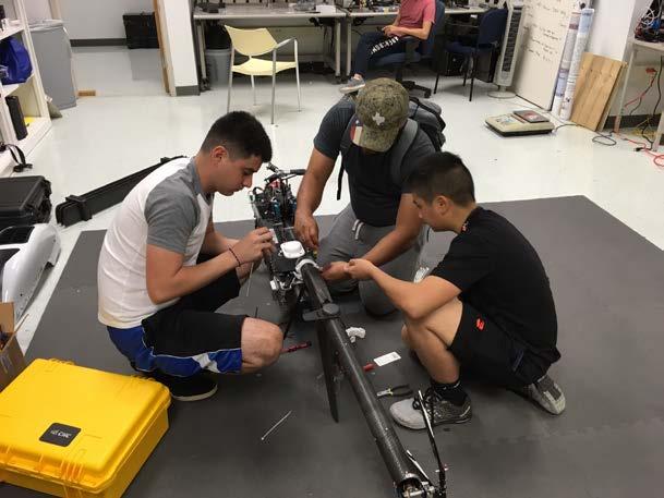
1 Assessing 3D Point Cloud Fidelity of UAS SfM Software Solutions Over Varying Terrain Michael Schwind, Michael J. Starek (Presenter) 18th Annual JALBTCX Airborne Coastal Mapping and Charting Technical Workshop, June 2017

2 Introduction Pix4D and Agisoft PhotoScan are well known commercial SfM photogrammetry software for UAS (drone) image processing. User-friendly, powerful, flexible, and offer good documentation and customer support. But can be relatively expensive. OpenDroneMap project is a suite of open source tools for UAS-SfM processing. Open source software removes expense, but the user should be prepared to have less software support and less control over the processing.


3 Structure from Motion (SfM) Workflow Simultaneous camera pose & scene geometry Match features in multiple overlapping images Feature detection e.g. SIFT Feature correspondence Sparse 3D Reconstruction Dense 3D matching Pose Reconstruction point cloud, DSM, ortho. SfM software offer many parameters but are black box in many aspects. Performance can vary dependent on many factors including terrain.
, absolute accuracy Goal: assess performance by evaluating results over varying terrain/texture We are not promoting one")
4 Objective Compare resulting 3D point clouds from Pix4D, Agisoft PhotoScan, and OpenDroneMap generated from a sequence of images acquired using a small UAS equipped with a consumer-grade digital camera: qualitative, statistical, cloud-to-cloud distance (Cloud Compare), absolute accuracy Goal: assess performance by evaluating results over varying terrain/texture We are not promoting one software or another! Simply reporting results


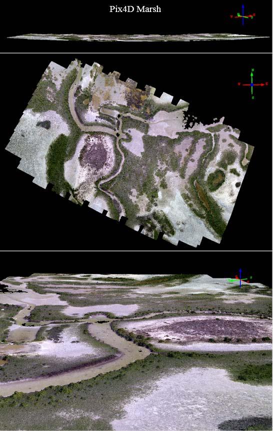
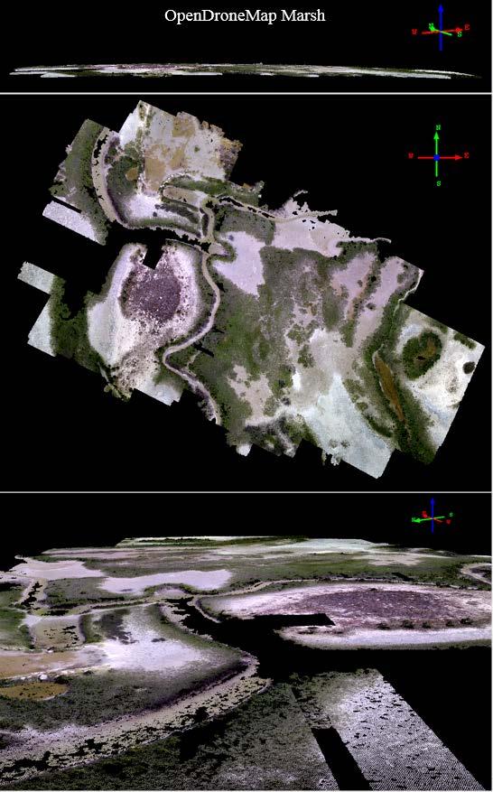
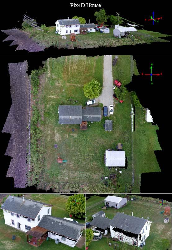
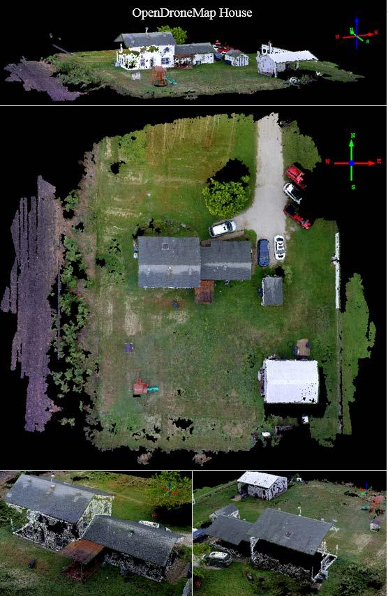
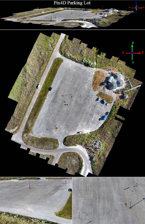
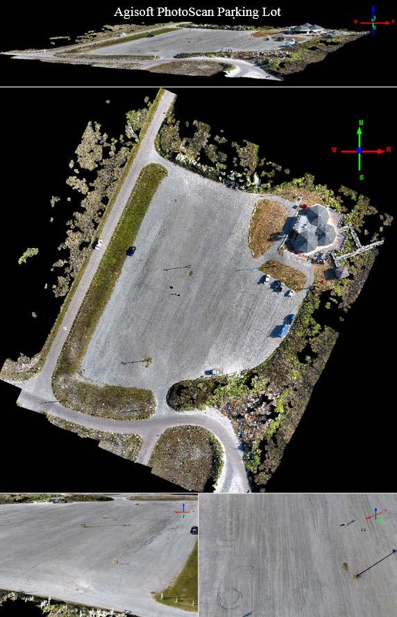
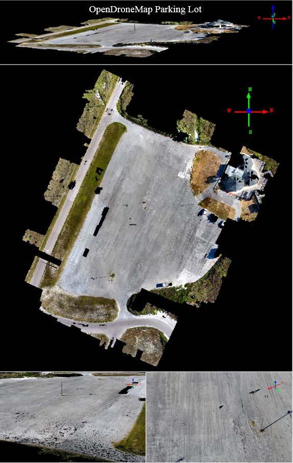
5 Marsh Study Areas Beach & Jetties Parking Lot Forested Peninsula House control no control

 Altitude (m) Image Resolution (cm)")

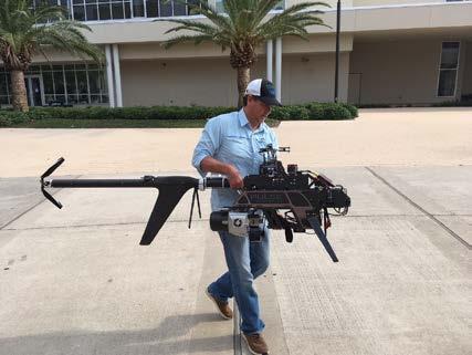
6 Methodology Data Collection DJI Phantom 3 Professional Sony EXMOR 12.4 M camera 2.82 pounds 23 min flight time Pix4D Capture Application Number of Images Percent Overlap Camera Angle (%) Altitude (m) Image Resolution (cm) Area Covered (m²) Marsh ,002 Beach and Jetties ,956 Parking Lot ,843 House ,630 Forested Peninsula ,888


7 Methodology Grount Truth z Comparison Ground control targets were used during UAS parking lot survey Riegl VZ-400 Terrestrial Laser Scan 600 m range 3 mm precision, 1σσ at 100m 20 millidegree scan angle ~1 cm pt spacing at 50 m filtered point cloud to remove non-ground objs.

 ultra-high quality means densifying at the original photo size/gsd.")
8 Agisoft PhotoScan Parameters Methodology Data Processing High accuracy makes software work with the original photo size; enables more accurate pose Sparse Point Cloud In the reference mode, the images are selected based on the measured camera locations. Speeds up feature matching Upper limit of key point features per image Dense Point Cloud Upper limit of tie point features used per photo (default) ultra-high quality means densifying at the original photo size/gsd. Depth filtering is used to filter out outlying points caused by noisy or badly focused imagery. Mild


9 Pix4D Parameters Methodology Data Processing Allows the user to specify the number of keypoints to be extracted. Defines the scale of the images at which additional 3D points are computed. Original image size was used This parameter defines the density of the point cloud. Set to high, creates a point per image scale pixel. Tried to use similar settings to Photoscan where possible to make fair assessment.


10 Methodology Data Processing odm-vagrant OpenDroneMap links multiple open source software together. These software are OpenDroneMap, CMVS, and PMVS. Each run time parameter must specify which link of the open source chain it controls. Limited control: e.g. min_num of features and density; defaults used

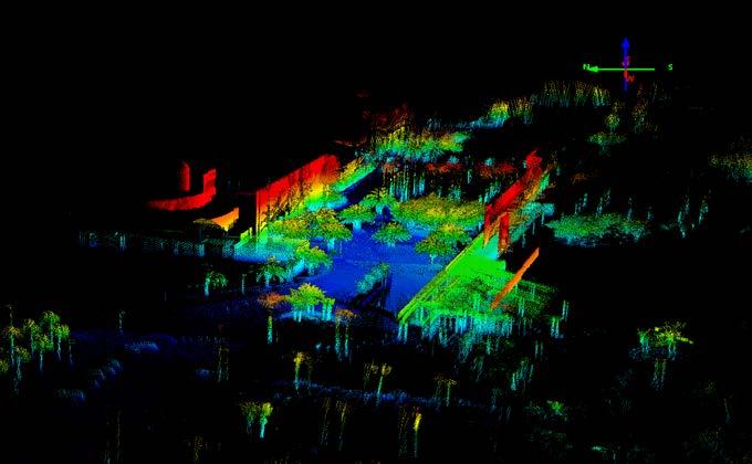
11 Results
, results in deformation 30.")
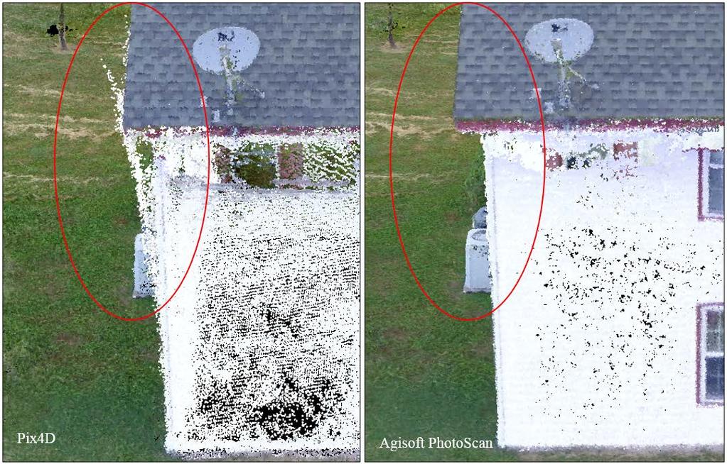
12 Results Things to point out: Bowl effect observed in Pix4D solution Vertical separation between point clouds PhotoScan Pix4D Likely from insufficient self-calibration (mainly radial distortion?), results in deformation 30.05% difference between the initial and optimized internal camera parameters for Pix4D
13 Results
14 Results
 masking the water can fix it, increasing tie")
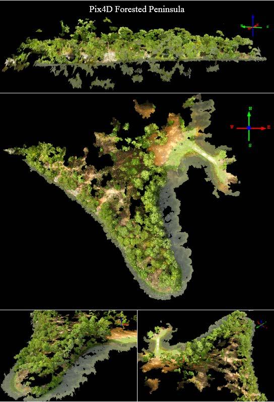
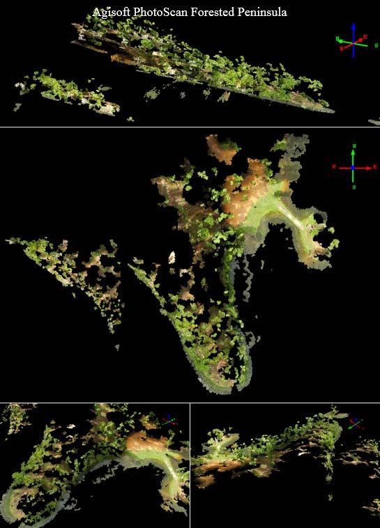
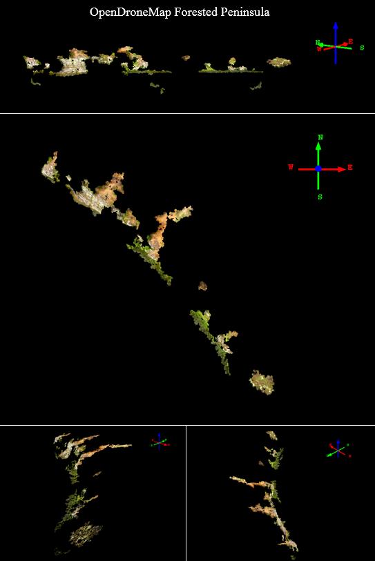
15 Likely cause of peninsula reconstruction failure Calm and reflective water features tricked the automated feature extraction and correspondence during SfM processing with PhotoScan/ODM (Pix4D handled it) masking the water can fix it, increasing tie points
16 Results


")

17 Tilt observed between UAS and TLS; VRS RTK GPS error in a control target (accuracy likely better) Results Cloud-to-Cloud Distances Noisier SfM Smoother Lidar
18 Point Cloud Characteristics Marsh Beach/Jetties Forested Peninsula Parking Lot *Ground Control House Results Key Point Matches Density (ppm²) Spacing (m) No. of Points 23,728 3, ,954,551 Agisoft Photoscan 644,740 3, ,394,900 Pix4D 323, ,935,784 OpenDroneMap 33,955 2, ,840,450 Agisoft Photoscan 427,372 3, ,769,094 Pix4D 207, ,132,233 OpenDroneMap 11,672 1, ,378,076 Agisoft Photoscan 114,291 2, ,996,628 Pix4D 39, ,861 OpenDroneMap 35,397 7, ,960,767 Agisoft Photoscan 953,894 9, ,510,589 Pix4D 436, ,010,131 OpenDroneMap 109, ,879,269 Agisoft Photoscan 1,842, ,638,333 Pix4D 427, ,111 OpenDroneMap Point Cloud Z Statistics Marsh Beach/Jetties Forested Peninsula Parking Lot *Ground Control House Min Z (m) Max Z (m) Mean Z (m) StdDev Z (m) Agisoft Photoscan Pix4D OpenDroneMap Agisoft Photoscan Pix4D OpenDroneMap Agisoft Photoscan Pix4D OpenDroneMap Agisoft Photoscan Pix4D OpenDroneMap Agisoft Photoscan Pix4D OpenDroneMap
19 Vertical Accuracy Pix4D Value (m) Class Pixel Count Area m² Percentage % cm > dz > - 4 cm Agisoft PhotoScan Value (m) Class Pixel Count Area m² Percentage % cm > dz > - 4 cm OpenDroneMap Value (m) Class Pixel Count Area m² Percentage % cm > dz > - 4 cm


 + dense enough PC for many DEM applications, decent orthos - lowest fidelity")
20 Take Away uncertainty in UAS-SfM software driven by many factors including terrain Conclusion + point cloud (PC) with the highest density 4 out of 5 surveys + successful at reconstructing every terrain type % of z-values fell within ~4 cm of the LiDAR - without control, bowl effect observed even with geotagging + best at 3D reconstruction of house + no bowl effect observed without control % of z-values fell within ~4 cm of the LiDAR - less dense PC, failed reconstruction of peninsula and some veg. + Free! Ongoing project with people contributing (improves) + dense enough PC for many DEM applications, decent orthos - lowest fidelity reconstruction, importing control is not precise Although we made efforts to make this a fair assessment, the range of parameter settings between software means these results should be taken with caution.


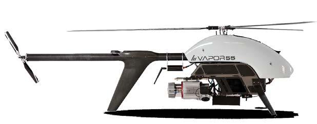
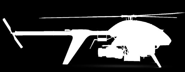
21 UAS Lidar Riegl VUX-LR Pulse Aerospace Vapor 55 Up to 1350 m 60 reflectivity SPAN INS with Litef µimu 200 Hz

22 Example page 022

23 Example page 023

24 Thank You JALBTCX! Questions? Contact Michael J. Starek Geospatial Surveying Engineering and GISc Texas A&M University-Corpus Christi,


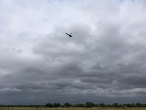
25 Mustang Island, March 2017 UAS-SfM Terrestrial Lidar ($1k drone, $400 camera) ($100+k sensor)
UAS Campus Survey Project
 ARTICLE STUDENTS CAPTURING SPATIAL INFORMATION NEEDS UAS Campus Survey Project Texas A&M University- Corpus Christi, home to the largest geomatics undergraduate programme in Texas, USA, is currently undergoing
EVOLUTION OF POINT CLOUD
 Figure 1: Left and right images of a stereo pair and the disparity map (right) showing the differences of each pixel in the right and left image. (source: https://stackoverflow.com/questions/17607312/difference-between-disparity-map-and-disparity-image-in-stereo-matching)
Unmanned Aerial Systems: A Look Into UAS at ODOT
 Ohio Department of Transportation John R. Kasich, Governor Jerry Wray, Director Unmanned Aerial Systems: Tim Burkholder, PS Mapping Manager Division of Engineering Office of CADD and Mapping Services Kyle
Tutorial (Beginner level): Orthomosaic and DEM Generation with Agisoft PhotoScan Pro 1.3 (without Ground Control Points)
: Orthomosaic and DEM Generation with Agisoft PhotoScan Pro 1.3 (without Ground Control Points)") Tutorial (Beginner level): Orthomosaic and DEM Generation with Agisoft PhotoScan Pro 1.3 (without Ground Control Points) Overview Agisoft PhotoScan Professional allows to generate georeferenced dense point
Tutorial (Beginner level): Orthomosaic and DEM Generation with Agisoft PhotoScan Pro 1.3 (without Ground Control Points) Overview Agisoft PhotoScan Professional allows to generate georeferenced dense point
Tutorial (Beginner level): Orthomosaic and DEM Generation with Agisoft PhotoScan Pro 1.3 (with Ground Control Points)
: Orthomosaic and DEM Generation with Agisoft PhotoScan Pro 1.3 (with Ground Control Points)") Tutorial (Beginner level): Orthomosaic and DEM Generation with Agisoft PhotoScan Pro 1.3 (with Ground Control Points) Overview Agisoft PhotoScan Professional allows to generate georeferenced dense point
Tutorial (Beginner level): Orthomosaic and DEM Generation with Agisoft PhotoScan Pro 1.3 (with Ground Control Points) Overview Agisoft PhotoScan Professional allows to generate georeferenced dense point
Todd King, PLS, LEED AP Business Developer
 Todd King, PLS, LEED AP Business Developer TKing@McKimCreed.com 38 YEARS 378 EMPLOYEES ENR Top 500 Design Firm ENR Top 200 Environmental ENR Southeast Engineer Firms POB Geospatial Top 100 Top 50 Trenchless
USING UNMANNED AERIAL VEHICLE (DRONE/FLYCAM) TECHNOLOGY IN SURVEY WORK OF PORTCOAST
 TECHNOLOGY IN SURVEY WORK OF PORTCOAST") USING UNMANNED AERIAL VEHICLE (DRONE/FLYCAM) TECHNOLOGY IN SURVEY WORK OF PORTCOAST 1. Capturing aerial images by using Drone Taking images by drones is currently applied in many fields especially in topographic
USING UNMANNED AERIAL VEHICLE (DRONE/FLYCAM) TECHNOLOGY IN SURVEY WORK OF PORTCOAST 1. Capturing aerial images by using Drone Taking images by drones is currently applied in many fields especially in topographic
Sasanka Madawalagama Geoinformatics Center Asian Institute of Technology Thailand
 Sasanka Madawalagama Geoinformatics Center Asian Institute of Technology Thailand This learning material was not prepared by ADB. The views expressed in this document are the views of the author/s and
Our Experiences with UAVs in Coastal Monitoring at Gator Lake. Capt. Joe Morrow MRD Associates, Inc. Destin, Florida
 Our Experiences with UAVs in Coastal Monitoring at Gator Lake Capt. Joe Morrow MRD Associates, Inc. Destin, Florida FSBPA 2018 National Conference on Beach Preservation Technology February 9, 2018 OVERVIEW
FOUR-BAND THERMAL MOSAICKING: A NEW METHOD TO PROCESS THERMAL IMAGERY FROM UAV FLIGHT YICHEN YANG YALE SCHOOL OF FORESTRY AND ENVIRONMENTAL STUDIES
 FOUR-BAND THERMAL MOSAICKING: A NEW METHOD TO PROCESS THERMAL IMAGERY FROM UAV FLIGHT YICHEN YANG YALE SCHOOL OF FORESTRY AND ENVIRONMENTAL STUDIES OUTLINE Background Objectives Methodology Results Calibration
Multiview Photogrammetry 3D Virtual Geology for everyone
 Multiview Photogrammetry 3D Virtual Geology for everyone A short course Marko Vrabec University of Ljubljana, Department of Geology FIRST: some background info Precarious structural measurements of fractures
Tutorial (Intermediate level): Dense Cloud Classification and DTM generation with Agisoft PhotoScan Pro 1.1
: Dense Cloud Classification and DTM generation with Agisoft PhotoScan Pro 1.1") Tutorial (Intermediate level): Dense Cloud Classification and DTM generation with Agisoft PhotoScan Pro 1.1 This tutorial illustrates how to perform dense point cloud classification in manual and automatic
Tutorial (Intermediate level): Dense Cloud Classification and DTM generation with Agisoft PhotoScan Pro 1.1 This tutorial illustrates how to perform dense point cloud classification in manual and automatic
Hardware 3D Mapping Systems
 Hardware 3D Mapping Systems About Us GreenValley International GreenValley International provides 3D mapping solutions that include mobile & aerial LiDAR acquisition hardware, post-processing software
The raycloud A Vision Beyond the Point Cloud
 The raycloud A Vision Beyond the Point Cloud Christoph STRECHA, Switzerland Key words: Photogrammetry, Aerial triangulation, Multi-view stereo, 3D vectorisation, Bundle Block Adjustment SUMMARY Measuring
a Geo-Odyssey of UAS LiDAR Mapping Henno Morkel UAS Segment Specialist DroneCon 17 May 2018
 a Geo-Odyssey of UAS LiDAR Mapping Henno Morkel UAS Segment Specialist DroneCon 17 May 2018 Abbreviations UAS Unmanned Aerial Systems LiDAR Light Detection and Ranging UAV Unmanned Aerial Vehicle RTK Real-time
REMOTE SENSING LiDAR & PHOTOGRAMMETRY 19 May 2017
 REMOTE SENSING LiDAR & PHOTOGRAMMETRY 19 May 2017 SERVICES Visual Inspections Digital Terrain Models Aerial Imagery Volume Computations Thermal Inspections Photo maps Aerial Video Training & Consultancy
Photo based Terrain Data Acquisition & 3D Modeling
 Photo based Terrain Data Acquisition & 3D Modeling June 7, 2013 Howard Hahn Kansas State University Partial funding by: KSU Office of Research and Sponsored Programs Introduction: Need Application 1 Monitoring
UAS for Surveyors. An emerging technology for the Geospatial Industry. Ian Murgatroyd : Technical Sales Rep. Trimble
 UAS for Surveyors An emerging technology for the Geospatial Industry Ian Murgatroyd : Technical Sales Rep. Trimble Project Overview Voyager Quarry, located near Perth Australia Typical of hard rock mines,
Drone2Map for ArcGIS: Bring Drone Imagery into ArcGIS. Will
 Drone2Map for ArcGIS: Bring Drone Imagery into ArcGIS Will Meyers @MeyersMaps A New Window on the World Personal Mapping for Micro-Geographies Accurate High Quality Simple Low-Cost Drone2Map for ArcGIS
Drone2Map: an Introduction. October 2017
 Drone2Map: an Introduction October 2017 Drone2Map: An Introduction Topics: - Introduction to Drone Mapping - Coordinate Systems - Overview of Drone2Map - Basic Drone2Map Workflow - 2D Data Processing -
UAS to GIS Utilizing a low-cost Unmanned Aerial System (UAS) for Coastal Erosion Monitoring
 for Coastal Erosion Monitoring") UAS to GIS Utilizing a low-cost Unmanned Aerial System (UAS) for Coastal Erosion Monitoring A New Window on the World Personal Mapping for Micro-Geographies Accurate High Quality Simple Low-Cost Drone2Map
UAS to GIS Utilizing a low-cost Unmanned Aerial System (UAS) for Coastal Erosion Monitoring A New Window on the World Personal Mapping for Micro-Geographies Accurate High Quality Simple Low-Cost Drone2Map
Reality Modeling Drone Capture Guide
 Reality Modeling Drone Capture Guide Discover the best practices for photo acquisition-leveraging drones to create 3D reality models with ContextCapture, Bentley s reality modeling software. Learn the
STARTING WITH DRONES. Data Collection and Remote Sensing with UAVs, etc. Dr. Bill Hazelton LS
 STARTING WITH DRONES Data Collection and Remote Sensing with UAVs, etc. Dr. Bill Hazelton LS What this Talk is About UAV-based data acquisition: What you need to get involved Processes in getting spatial
Photogrammetry for forest inventory.
 Photogrammetry for forest inventory. Marc Pierrot Deseilligny. IGN/ENSG, France. Jonathan Lisein. Ulg Gembloux Agro-Bio Tech, Belgium. 1- Photogrammetry 2- Application to forestry 3- Tools and proposed
COMPARISON OF LASER SCANNING, PHOTOGRAMMETRY AND SfM-MVS PIPELINE APPLIED IN STRUCTURES AND ARTIFICIAL SURFACES
 COMPARISON OF LASER SCANNING, PHOTOGRAMMETRY AND SfM-MVS PIPELINE APPLIED IN STRUCTURES AND ARTIFICIAL SURFACES 2012 ISPRS Melbourne, Com III/4, S.Kiparissi Cyprus University of Technology 1 / 28 Structure
Drones for research - Observing the world in 3D from a LiDAR-UAV
 Drones for research - Observing the world in 3D from a LiDAR-UAV Program lunch seminar: Lammert Kooistra: The Unmanned Aerial Remote Sensing Facility goes 3D: Unmanned Aerial Laser Scanning Sander Mücher:
MAPPING WITHOUT GROUND CONTROL POINTS: DOES IT WORK?
 MAPPING WITHOUT GROUND CONTROL POINTS: DOES IT WORK? BACKGROUND The economic advantages of Structure from Motion (SfM) mapping without any ground control points have motivated us to investigate an approach
Overview of the Trimble TX5 Laser Scanner
 Overview of the Trimble TX5 Laser Scanner Trimble TX5 Revolutionary and versatile scanning solution Compact / Lightweight Efficient Economical Ease of Use Small and Compact Smallest and most compact 3D
LiDAR data pre-processing for Ghanaian forests biomass estimation. Arbonaut, REDD+ Unit, Joensuu, Finland
 LiDAR data pre-processing for Ghanaian forests biomass estimation Arbonaut, REDD+ Unit, Joensuu, Finland Airborne Laser Scanning principle Objectives of the research Prepare the laser scanning data for
Innovation in 3D. Product Overview
 Innovation in 3D Product Overview TERRESTRIAL LASER SCANNING VQ-1560i MULTIPLE-TIME- AROUND-PROCESSING VZ-400i ECHO DIGITIZATION AIRBORNE LASER SCANNING VUX-1UAV HIGHLY ACCURATE EFFICIENT LIGHTWEIGHT RiCOPTER
TRAINING MATERIAL HOW TO OPTIMIZE ACCURACY WITH CORRELATOR3D
 TRAINING MATERIAL WITH CORRELATOR3D Page2 Contents 1. UNDERSTANDING INPUT DATA REQUIREMENTS... 4 1.1 What is Aerial Triangulation?... 4 1.2 Recommended Flight Configuration... 4 1.3 Data Requirements for
Case Study for Long- Range Beyond Visual Line of Sight Project. March 15, 2018 RMEL Transmission and Planning Conference
 Case Study for Long- Range Beyond Visual Line of Sight Project March 15, 2018 RMEL Transmission and Planning Conference 2014 HDR Architecture, 2016 2014 HDR, Inc., all all rights reserved. Helicopters
LiForest Software White paper. TRGS, 3070 M St., Merced, 93610, Phone , LiForest
 0 LiForest LiForest is a platform to manipulate large LiDAR point clouds and extract useful information specifically for forest applications. It integrates a variety of advanced LiDAR processing algorithms
Photogrammetric Performance of an Ultra Light Weight Swinglet UAV
 Photogrammetric Performance of an Ultra Light Weight Swinglet UAV J. Vallet, F. Panissod, C. Strecha, M. Tracol UAV-g 2011 - Unmanned Aerial Vehicle in Geomatics September 14-16, 2011ETH Zurich Summary
UAV s in Surveying: Integration/processes/deliverables A-Z. 3Dsurvey.si
 UAV s in Surveying: Integration/processes/deliverables A-Z Info@eGPS.net TODAY S PROGRAM Introduction to photogrammetry and 3Dsurvey Theoretical facts about the technology and basics of 3dsurvey Introduction
Journal Online Jaringan COT POLIPD (JOJAPS) Accuracy Assessment of Height Coordinate Using Unmanned Aerial Vehicle Images Based On Leveling Height
 Accuracy Assessment of Height Coordinate Using Unmanned Aerial Vehicle Images Based On Leveling Height") JOJAPS eissn 2504-8457 Abstract Journal Online Jaringan COT POLIPD (JOJAPS) Accuracy Assessment of Height Coordinate Using Unmanned Aerial Vehicle Images Based On Leveling Height Syamsul Anuar Bin Abu
JOJAPS eissn 2504-8457 Abstract Journal Online Jaringan COT POLIPD (JOJAPS) Accuracy Assessment of Height Coordinate Using Unmanned Aerial Vehicle Images Based On Leveling Height Syamsul Anuar Bin Abu
Generating highly accurate 3D data using a sensefly exom drone
 Generating highly accurate 3D data using a sensefly exom drone C. Álvarez 1, A. Roze 2, A. Halter 3, L. Garcia 4 1 Geomatic Engineer, Lehmann Géomètre SA 2 Application Engineer, sensefly SA 3 Geomatic
Structure from Motion: High resolution DEMs at any scale using everyday equipment
 Structure from Motion: High resolution DEMs at any scale using everyday equipment Anders Damsgaard Last revision: May 20, 2014 Outline Photogrammetry Method Examples Summary Photogrammetry using SfM Production
Introduction. Acute3D S.A.S. WTC Valbonne Sophia Antipolis. 120 route des Macarons.
 Introduction This benchmark compares the performances of the three main photo-based 3Dmodeling software. Five projects related to different kind of applications were led on the same machine and this document
THE ISPRS/EUROSDR BENCHMARK ON MULTI-PLATFORM PHOTOGRAMMETRY: RESULTS AND LESSON LEARNT FRANCESCO NEX AND MARKUS GERKE
 THE ISPRS/EUROSDR BENCHMARK ON MULTI-PLATFORM PHOTOGRAMMETRY: RESULTS AND LESSON LEARNT FRANCESCO NEX AND MARKUS GERKE Overview Summary of the results Statistics Data release What s next? ISPRS / EuroSDR
(Subsea) Keith Vickery Zupt LLC
 Keith Vickery Zupt LLC") (Subsea) Keith Vickery Zupt LLC kv@zupt.com Offshore subsea infrastructure surveys (pipeline inspection, well, XT, and manifold inspections) are required to ensure compliance with both internal operator,
(Subsea) Keith Vickery Zupt LLC kv@zupt.com Offshore subsea infrastructure surveys (pipeline inspection, well, XT, and manifold inspections) are required to ensure compliance with both internal operator,
MODELLING FOREST CANOPY USING AIRBORNE LIDAR DATA
 MODELLING FOREST CANOPY USING AIRBORNE LIDAR DATA Jihn-Fa JAN (Taiwan) Associate Professor, Department of Land Economics National Chengchi University 64, Sec. 2, Chih-Nan Road, Taipei 116, Taiwan Telephone:
Comparing workflow and point cloud outputs of the Trimble SX10 TLS and sensefly ebee Plus drone
 Comparing workflow and point cloud outputs of the Trimble SX10 TLS and sensefly ebee Plus drone Armin WEBER and Thomas LERCH Lerch Weber AG, Switzerland Key words: terrestrial laser scanner, Trimble SX10,
SimActive and PhaseOne Workflow case study. By François Riendeau and Dr. Yuri Raizman Revision 1.0
 SimActive and PhaseOne Workflow case study By François Riendeau and Dr. Yuri Raizman Revision 1.0 Contents 1. Introduction... 2 1.1. Simactive... 2 1.2. PhaseOne Industrial... 2 2. Testing Procedure...
POINT CLOUDS AND DERIVATIVES FOR NATIONWIDE GEOSPATIAL INFORMATION GEORGE VOSSELMAN
 POINT CLOUDS AND DERIVATIVES FOR NATIONWIDE GEOSPATIAL INFORMATION GEORGE VOSSELMAN OVERVIEW Point cloud generation and quality control New lidar technologies Dense matching Updating nationwide point clouds
Camera Drones Lecture 3 3D data generation
 Camera Drones Lecture 3 3D data generation Ass.Prof. Friedrich Fraundorfer WS 2017 Outline SfM introduction SfM concept Feature matching Camera pose estimation Bundle adjustment Dense matching Data products
Quality assessment of DIM on oblique images (preliminary results)
") FACULTY OF GEODESY AND CARTOGRAPHY W A R S A W U N I V E R S I T Y O F T E C H N O L O G Y Quality assessment of DIM on oblique images (preliminary results) Wojciech Ostrowski, Krzysztof Bakuła, Zdzisław
FACULTY OF GEODESY AND CARTOGRAPHY W A R S A W U N I V E R S I T Y O F T E C H N O L O G Y Quality assessment of DIM on oblique images (preliminary results) Wojciech Ostrowski, Krzysztof Bakuła, Zdzisław
Technical Considerations and Best Practices in Imagery and LiDAR Project Procurement
 Technical Considerations and Best Practices in Imagery and LiDAR Project Procurement Presented to the 2014 WV GIS Conference By Brad Arshat, CP, EIT Date: June 4, 2014 Project Accuracy A critical decision
Quality Report Generated with version
 Quality Report Generated with version 3.3.67 Important: Click on the different icons for: Help to analyze the results in the Quality Report Additional information about the feature Click here for additional
2. POINT CLOUD DATA PROCESSING
 Point Cloud Generation from suas-mounted iphone Imagery: Performance Analysis A. D. Ladai, J. Miller Towill, Inc., 2300 Clayton Road, Suite 1200, Concord, CA 94520-2176, USA - (andras.ladai, jeffrey.miller)@towill.com
DIGITAL SURFACE MODELS OF CITY AREAS BY VERY HIGH RESOLUTION SPACE IMAGERY
 DIGITAL SURFACE MODELS OF CITY AREAS BY VERY HIGH RESOLUTION SPACE IMAGERY Jacobsen, K. University of Hannover, Institute of Photogrammetry and Geoinformation, Nienburger Str.1, D30167 Hannover phone +49
DEVELOPING METHODOLOGY TO MAP TREE CANOPY IN URBAN AREAS FROM LOW COST COMMERCIAL UAVS
 DEVELOPING METHODOLOGY TO MAP TREE CANOPY IN URBAN AREAS FROM LOW COST COMMERCIAL UAVS Niluka Munasinghe 1, U.I. Manatunga 1, H.M.R. Premasiri 1, N. Lakmal Deshapriya 2, S.L. Madawalagama 2 and Lal Samarakoon
Airborne Laser Survey Systems: Technology and Applications
 Abstract Airborne Laser Survey Systems: Technology and Applications Guangping HE Lambda Tech International, Inc. 2323B Blue Mound RD., Waukesha, WI-53186, USA Email: he@lambdatech.com As mapping products
UAV Flight Operations for Mapping. Precision. Accuracy. Reliability
 UAV Flight Operations for Mapping Precision. Accuracy. Reliability Part One: Why is Mapping different? Part Two: What about accuracy and precision? Part Three: What is the Workflow? Part Four: AGENDA What
Trimble GeoSpatial Products
 Expanding Solutions for Photogrammetric and Remote Sensing Professionals 55 th Photogrammetric Week in Stuttgart September 7 th 2015 Tobias Heuchel, Trimble Stuttgart, Germany Trimble GeoSpatial Products
NATIONWIDE POINT CLOUDS AND 3D GEO- INFORMATION: CREATION AND MAINTENANCE GEORGE VOSSELMAN
 NATIONWIDE POINT CLOUDS AND 3D GEO- INFORMATION: CREATION AND MAINTENANCE GEORGE VOSSELMAN OVERVIEW National point clouds Airborne laser scanning in the Netherlands Quality control Developments in lidar
Practical Considerations of UAS Operations on Data Quality
 Practical Considerations of UAS Operations on Data Quality Precision. Accuracy. Reliability OVERVIEW Project Planning and Execution Ground Control Data Processing and Delivery 1 OVERVIEW Get Legal: Section
Photogrammetry: DTM Extraction & Editing
 Photogrammetry: DTM Extraction & Editing How can one determine the x, y, and z of a location? Approaches to DTM Extraction Ground surveying Digitized topographic maps Traditional photogrammetry Hardcopy
Quality Accuracy Professionalism
 GeoWing - who are we? Mapping Data Service Provider Lidar Multispectral Topographic and Planimetric Maps Elevation Models Point Clouds / 3D Models Orthophotography FAA-Authorized UAS Operators WOSB / DBE
Tools, Tips and Workflows Geiger-Mode LIDAR Workflow Review GeoCue, TerraScan, versions and above
 GeoCue, TerraScan, versions 015.005 and above Martin Flood August 8, 2016 Geiger-mode lidar data is getting a lot of press lately as the next big thing in airborne data collection. Unlike traditional lidar
Open Pit Mines. Terrestrial LiDAR and UAV Aerial Triangulation for. Figure 1: ILRIS at work
 Terrestrial LiDAR and UAV Aerial Triangulation for Open Pit Mines Figure 1: ILRIS at work Figure 2: Geo-Copter X-8000 taking off ay what you will about the past few years, it has produced some useful tools
Trimble Geospatial Division Integrated Solutions for Geomatics professions. Volker Zirn Regional Sales Representative
 Trimble Geospatial Division Integrated Solutions for Geomatics professions Volker Zirn Regional Sales Representative 1 Agenda Trimble GeoSpatial Division Airborne System Solutions Trimble Inpho Software
High resolution survey and orthophoto project of the Dosso-Gaya region in the Republic of Niger. by Tim Leary, Woolpert Inc.
 High resolution survey and orthophoto project of the Dosso-Gaya region in the Republic of Niger by Tim Leary, Woolpert Inc. Geospatial Solutions Photogrammetry & Remote Sensing LiDAR Professional Surveying
Aerial and Mobile LiDAR Data Fusion
 Creating Value Delivering Solutions Aerial and Mobile LiDAR Data Fusion Dr. Srini Dharmapuri, CP, PMP What You Will Learn About LiDAR Fusion Mobile and Aerial LiDAR Technology Components & Parameters Project
POLE PHOTOGRAMMETRY WITH AN ACTION CAMERA FOR FAST AND ACCURATE SURFACE MAPPING
 POLE PHOTOGRAMMETRY WITH AN ACTION CAMERA FOR FAST AND ACCURATE SURFACE MAPPING J. A. Gonçalves a,b, *, O. F. Moutinho a, A. C. Rodrigues a a University of Porto, Science Faculty, Rua Campo Alegre, 4169-007,
LiDAR & Orthophoto Data Report
 LiDAR & Orthophoto Data Report Tofino Flood Plain Mapping Data collected and prepared for: District of Tofino, BC 121 3 rd Street Tofino, BC V0R 2Z0 Eagle Mapping Ltd. #201 2071 Kingsway Ave Port Coquitlam,
UAV Surveying II. Precision. Accuracy. Reliability
 UAV Surveying II Precision. Accuracy. Reliability Part One: Project Lifecycle Deliverables Part Two: Evaluation of UAV Data Accuracy and Examples of Error Part Three: AGENDA Review of Results Examples
VALIDATION OF A NEW 30 METER GROUND SAMPLED GLOBAL DEM USING ICESAT LIDARA ELEVATION REFERENCE DATA
 VALIDATION OF A NEW 30 METER GROUND SAMPLED GLOBAL DEM USING ICESAT LIDARA ELEVATION REFERENCE DATA M. Lorraine Tighe Director, Geospatial Solutions Intermap Session: Photogrammetry & Image Processing
Analytical and Computer Cartography Winter Lecture 14: Three Dimensional Mapping and Modeling
 Analytical and Computer Cartography Winter 2017 Lecture 14: Three Dimensional Mapping and Modeling 3D measurement systems: remote sensing of objects First generation DEMs, photogrammetry and contour conversion
Aerial Mapping using UAS. Jeff Campbell
 Aerial Mapping using UAS Jeff Campbell 1 Agenda 1. Introduction 2. UAS Mapping Explained 3. Use Cases / Outputs 4. Technologies 5. Training Methods 6. Implementation Strategies 7. Emerging Technologies
Merging LiDAR Data with Softcopy Photogrammetry Data
 Merging LiDAR Data with Softcopy Photogrammetry Data Cindy McCallum WisDOT\Bureau of Technical Services Surveying & Mapping Section Photogrammetry Unit Overview Terms and processes Why use data from LiDAR
James Van Rens CEO Riegl USA, Inc. Mining Industry and UAV s combined with LIDAR Commercial UAV Las Vegas October 2015 James Van Rens CEO Riegl USA
 James Van Rens CEO Riegl USA, Inc. Mining Industry and UAV s combined with LIDAR Commercial UAV Las Vegas October 2015 James Van Rens CEO Riegl USA COST EFFECIENCY CONTINUUM LIDAR and IMU Partnership Technology
Presentation Outline. Preserving the Evidence: Multi-Platform 3D Reality Captures for Tornado Damage. Objectives. Learning from Tornado Damage
 Presentation Outline Preserving the Evidence: Multi-Platform 3D Reality Captures for Tornado Damage J. ArnWomble, Ph.D., P.E. Assistant Professor of Civil Engineering West Texas A&M University Canyon/Amarillo,
CE 59700: LASER SCANNING
 Digital Photogrammetry Research Group Lyles School of Civil Engineering Purdue University, USA Webpage: http://purdue.edu/ce/ Email: ahabib@purdue.edu CE 59700: LASER SCANNING 1 Contact Information Instructor:
Surveying like never before
 CAD functionalities GCP Mapping and Aerial Image Processing Software for Land Surveying Specialists Surveying like never before www.3dsurvey.si Modri Planet d.o.o., Distributors: info@3dsurvey.si +386
Processed :36:54 Average Ground Sampling Distance (GSD) Time for Initial Processing (without report)
 Time for Initial Processing (without report)") Important: Click on the different icons for: Dronedata Back Office Server Generated Quality Report Phase 1 Time 07h:33m:02s Phase 2 Time 02h:58m:08s Phase 3 Time Not Applicable Total Time All Phases 10h:31m:08s
Important: Click on the different icons for: Dronedata Back Office Server Generated Quality Report Phase 1 Time 07h:33m:02s Phase 2 Time 02h:58m:08s Phase 3 Time Not Applicable Total Time All Phases 10h:31m:08s
Presented at the FIG Congress 2018, May 6-11, 2018 in Istanbul, Turkey
 Presented at the FIG Congress 2018, May 6-11, 2018 in Istanbul, Turkey Evangelos MALTEZOS, Charalabos IOANNIDIS, Anastasios DOULAMIS and Nikolaos DOULAMIS Laboratory of Photogrammetry, School of Rural
Commercial suas The Right Tool for the Right Job
 Commercial suas The Right Tool for the Right Job Presentation Objectives Overview of current data collection technologies UAS Systems Overview Surveyor 2.0 Project Case Study Mobile LiDAR & suas How Do
LIDAR MAPPING FACT SHEET
 1. LIDAR THEORY What is lidar? Lidar is an acronym for light detection and ranging. In the mapping industry, this term is used to describe an airborne laser profiling system that produces location and
DENSE 3D POINT CLOUD GENERATION FROM UAV IMAGES FROM IMAGE MATCHING AND GLOBAL OPTIMAZATION
 DENSE 3D POINT CLOUD GENERATION FROM UAV IMAGES FROM IMAGE MATCHING AND GLOBAL OPTIMAZATION S. Rhee a, T. Kim b * a 3DLabs Co. Ltd., 100 Inharo, Namgu, Incheon, Korea ahmkun@3dlabs.co.kr b Dept. of Geoinformatic
Redefining Airborne LiDAR Introduction to RIEGL LMS in Airborne LiDAR
 Redefining Airborne LiDAR Introduction to RIEGL LMS in Airborne LiDAR Andres Vargas Integration Systems Engineer LAGF Mexico City, Mexico September 23th, 2014 1 Airborne Laser Scanning History and Evolution
A New Protocol of CSI For The Royal Canadian Mounted Police
 A New Protocol of CSI For The Royal Canadian Mounted Police I. Introduction The Royal Canadian Mounted Police started using Unmanned Aerial Vehicles to help them with their work on collision and crime
Orthophotography and LiDAR Terrain Data Collection Rogue River, Oregon Final Report
 Orthophotography and LiDAR Terrain Data Collection Rogue River, Oregon Final Report Prepared by Sky Research, Inc. 445 Dead Indian Memorial Road Ashland, OR 97520 Prepared for Rogue Valley Council of Governments
Quality Report Generated with Pix4Dmapper Pro version
 Quality Report Generated with Pix4Dmapper Pro version 3.2.23 Important: Click on the different icons for: Help to analyze the results in the Quality Report Additional information about the sections Click
An Introduction to Lidar & Forestry May 2013
 An Introduction to Lidar & Forestry May 2013 Introduction to Lidar & Forestry Lidar technology Derivatives from point clouds Applied to forestry Publish & Share Futures Lidar Light Detection And Ranging
SPAR, ELMF 2013, Amsterdam. Laser Scanning on the UK Highways Agency Network. Hamish Grierson Blom Uk
 SPAR, ELMF 2013, Amsterdam Laser Scanning on the UK Highways Agency Network Hamish Grierson Blom Uk www.blomasa.com www.blom-uk.co.uk Blom UK Part of the Blom Group Blom Group - Europe s largest aerial
Applications of Mobile LiDAR and UAV Sourced Photogrammetry
 Applications of Mobile LiDAR and UAV Sourced Photogrammetry Thomas J. Pingel and Earle W. Isibue Northern Illinois University 2017 Illinois GIS Association (ILGISA) Annual Meeting October 2-4, 2017 tpingel.org
Integrated Multi-Source LiDAR and Imagery
 Figure 1: AirDaC aerial scanning system Integrated Multi-Source LiDAR and Imagery The derived benefits of LiDAR scanning in the fields of engineering, surveying, and planning are well documented. It has
AIRBORNE GEIGER MODE LIDAR - LATEST ADVANCEMENTS IN REMOTE SENSING APPLICATIONS RANDY RHOADS
 Place image here (10 x 3.5 ) AIRBORNE GEIGER MODE LIDAR - LATEST ADVANCEMENTS IN REMOTE SENSING APPLICATIONS RANDY RHOADS Geospatial Industry Manager HARRIS.COM #HARRISCORP Harris Company Information SECURITY
The Use of UAS in modern field work
 The Use of UAS in modern field work SplitRS 2015, Thessaloniki, GREECE 22/05/2015 1 ebee by sensefly Swiss-made UAV Fully autonomous flight Suitable for: Mapping, GIS, Surveying Precision Agriculture Environmental
The use of different data sets in 3-D modelling
 The use of different data sets in 3-D modelling Ahmed M. HAMRUNI June, 2014 Presentation outlines Introduction Aims and objectives Test site and data Technology: Pictometry and UltraCamD Results and analysis
Surface and Terrain Models
 Advanced Matching Techniques for High Precision Surface and Terrain Models Introduction Comeback of image matching for DTM & DSM generation Very few professional tools for DSM generation from image matching
Mosaicking Software: A comparison of various software suites. Geosystems Research Institute Report 5071
 Mosaicking Software: A comparison of various software suites Geosystems Research Institute Report 5071 Lee Hathcock (Mississippi State University) Ryan MacNeille (Altavian, Inc.) 3-24-2016 Mosaicking software
Digital Photogrammetry Software Comparison for Rock Mass Characterization
 ARMA 18 1211 Digital Photogrammetry Software Comparison for Rock Mass Characterization Becker, R.E., Galayda, L.J., MacLaughlin, M.M. Montana Tech, Butte, Montana, USA Copyright 2018 ARMA, American Rock
TLS Parameters, Workflows and Field Methods
 TLS Parameters, Workflows and Field Methods Marianne Okal, UNAVCO June 20 th, 2014 How a Lidar instrument works (Recap) Transmits laser signals and measures the reflected light to create 3D point clouds.
2010 LiDAR Project. GIS User Group Meeting June 30, 2010
 2010 LiDAR Project GIS User Group Meeting June 30, 2010 LiDAR = Light Detection and Ranging Technology that utilizes lasers to determine the distance to an object or surface Measures the time delay between
3D reconstruction how accurate can it be?
 Performance Metrics for Correspondence Problems 3D reconstruction how accurate can it be? Pierre Moulon, Foxel CVPR 2015 Workshop Boston, USA (June 11, 2015) We can capture large environments. But for
STATUS OF AIRBORNE OBLIQUE IMAGING EUROSDR COMMISSION I PROJECT OBLIQUE IMAGERY. Markus Gerke May 15, 2014
 STATUS OF AIRBORNE OBLIQUE IMAGING EUROSDR COMMISSION I PROJECT OBLIQUE IMAGERY Markus Gerke May 15, 2014 THE FIRST AIRBORNE PHOTOS WERE OBLIQUE First recorded aerial photograph in the US (Boston), by
Lecture 11. LiDAR, RADAR
 NRMT 2270, Photogrammetry/Remote Sensing Lecture 11 Calculating the Number of Photos and Flight Lines in a Photo Project LiDAR, RADAR Tomislav Sapic GIS Technologist Faculty of Natural Resources Management
Coastal Survey of archaeological sites using drones
 Coastal Survey of archaeological sites using drones In Poseidon s Realm XXI Underwater archaeology - interdisciplinary approaches and technical innovations Dimitrios Skarlatos, Savvidou Eleni Photogrammetric