2D Model Implementation for Complex Floodplain Studies. Sam Crampton, P.E., CFM Dewberry
|
|
|
- Clifton Cross
- 6 years ago
- Views:
Transcription


1 2D Model Implementation for Complex Floodplain Studies Sam Crampton, P.E., CFM Dewberry


2 2D Case Studies Case Study 1 Rain-on-Grid 2D floodplain simulation for unconfined flat topography in coastal plain areas of Georgia Case Study 2 1D/2D Integrated floodplain modeling for complex flooding in Texas 2 xp2d Implementation for Complex Floodplain Studies, March 1, 2013

3 2D Case Studies Case Study 3 2D floodplain modeling for dam/levee breach analysis Case Study 4 Embankment Opening to increase conveyance and improve circulation Case Study 5 2D Modeling of wash area 3 xp2d Implementation for Complex Floodplain Studies, March 1, 2013
4 Flat Coastal Plain Floodplain Modeling GA coastal communities have inland areas of very flat terrain Flow travels in many directions Frequent divergence/convergence and break out of flows Interconnected and closed basin ponds and swamps Very challenging for a 1D model User cannot confidently estimate flow direction in 1D Flow divergence and convergence requires many river reaches and is not efficient to model 4 xp2d Implementation for Complex Floodplain Studies, March 1, 2013

5 Effective Zone A Floodplains No supporting engineering data or even documentation of methodologies used Appear to be developed using: Soil data USGS topography Very simple floodplain boundaries Poor match to new LiDAR data 5 xp2d Implementation for Complex Floodplain Studies, March 1, 2013

6 What is Rain of Grid Hydrology? Applying rainfall directly to 2D grid cells Let xp2d figure out where the rain drops flow and accumulate! No need to delineate watershed boundaries Infiltration losses accounted for each grid cell Very rapid to create Source: content/uploads/flooding Webinar.pdf 6 xp2d Implementation for Complex Floodplain Studies, March 1, 2013
7 Validation of Rain on Grid New technology, relatively untested Limited research in area Must perform a thorough testing and calibration of parameters to ensure results are valid Plotted regional curves by analyzing available USGS gages in coastal plain region Effectiveness of rain on grid will vary in different hydrologic conditions Generally more effective in flat areas 7 xp2d Implementation for Complex Floodplain Studies, March 1, 2013
8 Validation of Rain of Grid Hydrology Coastal Georgia Regional Stream Gage Analysis: Drainage Area vs. Peak Flow Using 29 USGS Gages in 12 County Area Discharge (cfs) Bulletin 17B XPSWMM Output Power (Bulletin 17B) Power ( 66.7 C.L.) 100 Power (+66.7 C.L.) Power (+95% C.L.) 10 Power ( 95% C.L.) Linear (Trib4) Drainage Area (Sq. Mi.) 8 xp2d Implementation for Complex Floodplain Studies, March 1, 2013


9 9 xp2d Implementation for Complex Floodplain Studies, March 1, 2013
10 Scalable Solution xp2d provided a very scalable solution Basic level of analysis purely 2D grid based Can enhance detail by adding 1D features 1D culvert features are generally required to hydro-enforce embankments 1D channel features can help improve hydrology where channels provide significant conveyance, more critical in areas of steeper terrain Grid cell requires different thinking Minor differences in results between 100 ft and 200 ft cell sizes was experienced 10 xp2d Implementation for Complex Floodplain Studies, March 1, 2013

11 1. Basic floodplain from 2D only model 2. Refinement of model with 1D links for cross drains 3. Rerun refined model which reduces upstream flooding and increases downstream flooding 11 xp2d Implementation for Complex Floodplain Studies, March 1, 2013


12 Refined Zone A Floodplain Delineations 12 Powerpoint title goes here December 20, 2011


13 Refined Zone A Floodplain Delineations 13 xp2d Implementation for Complex Floodplain Studies, March 1, 2013

14 14 Powerpoint title goes here December 20, 2011

15 15 Powerpoint title goes here December 20, 2011

16 16 Powerpoint title goes here December 20, 2011
17 xp2d in Flat Topography Summary Benefits of the xp2d model Very fast to develop basic floodplain for very large area (several hundred square miles) Straight forward to integrate 1D features and refine 2D model, much easier than many other 2D models Rain-on-Grid method can identify comprehensive floodplains within a study boundary, not just scoped reaches Recommendations Smaller isn t better when it comes to selecting 2D grid cells Recommend delineating floodplain within GIS at a finer resolution since every cell has a flood elevation 17 xp2d Implementation for Complex Floodplain Studies, August 30, 2012
18 xp2d in Flat Topography Summary Challenges Simulations for large area take a long time Model grid too course for final Floodplain Boundary Standard compliant flood hazard area Rain on grid model creates floodplain for 100% of cells Must determine threshold to define a flood Solutions Tested 2D cell size sensitivity and optimized for efficiency Screen final results to only include cells with depth >1 foot Redelineate using finer mesh terrain (10 foot) Being pilot tested for First-Pass analysis to aid discovery and Risk Assessment 18 xp2d Implementation for Complex Floodplain Studies, August 30, 2012
19 Complex Hydraulics in Texas Highly altered flooding source containing: Excavated flood relief channel parallel to and below a perched main channel Converging flooding sources Multiple openings through major road embankments Major grading activities have occurred influencing flow direction Very challenging to develop a 1D model Integrated 1D-2D model provided a solution for modeling complex conditions 19 xp2d Implementation for Complex Floodplain Studies, March 1, 2013

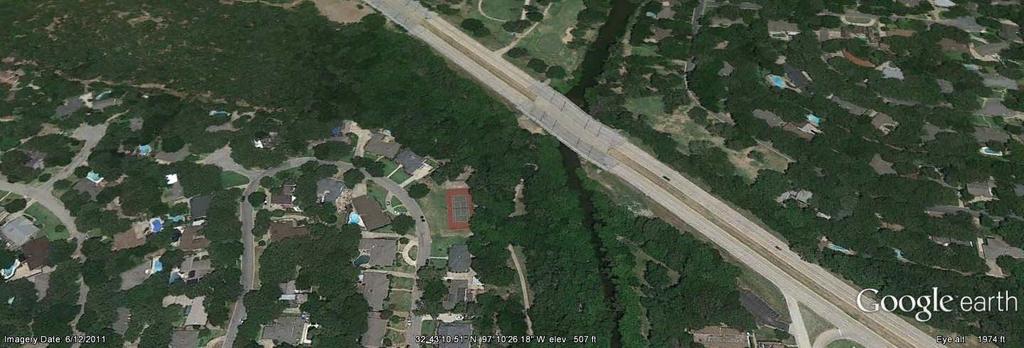
20 04/22/ xp2d Implementation for Complex Floodplain Studies, March 1, 2013


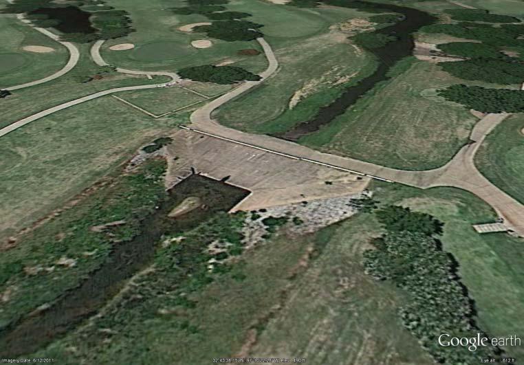
21 Integrated 1D/2D Model Overbank areas modeled as 2D grid 1D 2D interface allows flow exchange between 1D/2D engines by balancing energy grade 21 xp2d Implementation for Complex Floodplain Studies, March 1, 2013 Hydraulic structures modeled in 1D Well defined channels modeled in 1D

22 Results Highlight Need for 2D 22 xp2d Implementation for Complex Floodplain Studies, March 1, 2013


23 INSERT ANIMATION 23 XP-2D Implementation for Complex Floodplain Studies, August 30, 2012

 24 xp2d Implementation for Complex Floodplain Studies, March 1,")
24 Parallel HEC-RAS Model Traditional 1D models are generally more readily accepted for FEMA studies xp2d model enabled HEC-RAS geometry setup to be confidently determined xp2d grid elevations could be contoured to determine RAS cross section alignments Areas of negligible energy slope can be modeled in RAS as storage nodes Calibration and comparison of results HEC-RAS generally gave a little higher results Hard to model in just 1D where elevations suddenly change laterally (break outs) 24 xp2d Implementation for Complex Floodplain Studies, March 1, 2013
25 xp2d for Complex Hydraulics Benefits of the Integrated xp1d/2d model Straight forward to integrate 1D features and refine 2D model, much easier than many other 2D models SWMM Link-Node method is very versatile, enabling complex hydraulic structures to be effectively modeled Good stability, relatively low effort required to stabilize model compared to other dynamic models on the market Excellent continuity (generally easier than just 1D model) Recommendations Develop 1D model incrementally to help diagnose stability issues Choose suitable mesh resolution to optimize run times 25 xp2d Implementation for Complex Floodplain Studies, March 1, 2013
26 2D Dam/Levee Breach Modeling Above ground pumped storage reservoir Ring levee, not a traditional dam across a valley More places for the dam to breach Major residential areas on one side of dam Unconfined flooding making 1D model challenging FLO-2D model provided solution to route breach wave from multiple breach locations 26 2D Modeling for Complex Flood and Dam Break Studies - November 29, 2012


27 Sensitivity of Breach Location 27 2D Modeling for Complex Flood and Dam Break Studies - November 29, 2012

28 Arrival Times 28 2D Modeling for Complex Flood and Dam Break Studies - November 29, 2012
29 2D Dam/Levee Breach Modeling Benefits of the FLO-2D model Enabled overland flow to be modeled including inertia which would have been ignored by a basic1d model that would have funneled all flow through channel Enabled the risk sensitivity of the breach location to be clearly understood 29 2D Modeling for Complex Flood and Dam Break Studies - November 29, 2012
30 Embankment Opening to Increase Conveyance and Improve Circulation Using 2D models to identify hydraulic effects of opening up sections of roadway embankment Restores the natural function and flow of floodplain 2D model demonstrates how it is not a 1D problem 30 2D Modeling for Complex Flood and Dam Break Studies - November 29, 2012
31 2D Modeling 31 Investigation of Restoration of Hydrology on Mobile Bay Causeway July 16, 2013

32 2D Modeling Over Alluvial Wash 32 Powerpoint title goes here December 20, 2011
33 2D Levee Breach 33 Powerpoint title goes here December 20, 2011
34 Questions? Sam Crampton, P.E. Senior Associate Dewberry (office) (cell) 34 xp2d Implementation for Complex Floodplain Studies, March 1, 2013
Comparing 2D Approaches for Complex FEMA Studies
 Comparing 2D Approaches for Complex FEMA Studies Presented by: Ted Cassidy, P.E., PH (STARR2-Dewberry) Sam Crampton, P.E., CFM (STARR2-Dewberry) Mike DePue, P.E., CFM (STARR2-Atkins) Agenda Introduction
2D Modeling for Approximate Areas. Monica S. Urisko, P.E. CFM
 2D Modeling for Approximate Areas Monica S. Urisko, P.E. CFM Ferrin P. Affleck, P.E. CFM Outline Types of Modeling Available Steady vs Unsteady 1D vs 2D Software available Basics of 2D modeling Inputs
2-D Hydraulic Modeling Theory & Practice
 2-D Hydraulic Modeling Theory & Practice Author: Maged A. Aboelata, PhD, PE, CFM Presenter: Heather Zhao, PE, CFM October 2017 Presentation Outline * 1-D vs. 2-D modeling * Theory of 2-D simulation * Commonly
2D Large Scale Automated Engineering for FEMA Floodplain Development in South Dakota. Eli Gruber, PE Brooke Conner, PE
 2D Large Scale Automated Engineering for FEMA Floodplain Development in South Dakota Eli Gruber, PE Brooke Conner, PE Project Acknowledgments FEMA Region 8 Staff: Brooke Conner, PE Casey Zuzak, GISP Ryan
2014 AWRA Annual Water Resources Conference November 5, 2014 Tysons Corner, VA
 2014 AWRA Annual Water Resources Conference November 5, 2014 Tysons Corner, VA HEC-RAS Overview, History, & Future How HEC-RAS Works Model Development Standard FEMA Assumptions Building A Model FEMA Levels
2D Hydraulic Modeling, Steering Stream Restoration Design
 2D Hydraulic Modeling, Steering Stream Restoration Design PREPARED FOR: EcoStream 2018 Stream Ecology & Restoration Conference Presented By: Matthew D. Gramza, P.E., CFM, CPESC Civil & Environmental Consultants,
Upper Trinity River Corridor Development Certificate Model Updates. Flood Management Task Force Meeting April 20, 2018
 Upper Trinity River Corridor Development Certificate Model Updates Flood Management Task Force Meeting April 20, 2018 Agenda Review of the Phase II Upper Trinity Watershed CDC Model Development Hydrology
Harris County Flood Control District HEC-RAS 2D Modeling Guidelines (Standardizing HEC-RAS 2D Models for Submittal Within Harris County)
") Harris County Flood Control District HEC-RAS 2D Modeling Guidelines (Standardizing HEC-RAS 2D Models for Submittal Within Harris County) Presented by: April 27, 2017 Matthew Zeve, P.E., CFM Harris County
Harris County Flood Control District HEC-RAS 2D Modeling Guidelines (Standardizing HEC-RAS 2D Models for Submittal Within Harris County) Presented by: April 27, 2017 Matthew Zeve, P.E., CFM Harris County
Day 1. HEC-RAS 1-D Training. Rob Keller and Mark Forest. Break (9:45 am to 10:00 am) Lunch (12:00 pm to 1:00 pm)
 Lunch (12:00 pm to 1:00 pm)") Day 1 HEC-RAS 1-D Training Rob Keller and Mark Forest Introductions and Course Objectives (8:00 am to 8:15 am) Introductions: Class and Content Module 1 Open Channel Hydraulics (8:15 am to 9:45 am) Lecture
Day 1 HEC-RAS 1-D Training Rob Keller and Mark Forest Introductions and Course Objectives (8:00 am to 8:15 am) Introductions: Class and Content Module 1 Open Channel Hydraulics (8:15 am to 9:45 am) Lecture
Urban Floodplain modeling- Application of Two-Dimensional Analyses to Refine Results
 Urban Floodplain modeling- Application of Two-Dimensional Analyses to Refine Results Prabharanjani Madduri, P.E., CFM Mathini Sreetharan, Ph.D., P.E., CFM Hydraulic modeling of urban areas and issues Modeling
Comparison of 1D and 2D Surface Water Models for Solid Waste Facilities. Garth R. Bowers, P.E., Carl E. Bueter, P.E., Larry Henk
 Comparison of 1D and 2D Surface Water Models for Solid Waste Facilities Garth R. Bowers, P.E., Carl E. Bueter, P.E., Larry Henk Introduction Importance of Accurate Floodplain Delineation Required by Federal
Advanced 1D/2D Modeling Using HEC-RAS
 Advanced 1D/2D Modeling Using HEC-RAS Davis, California Objectives This is an advanced course in applying computer program HEC-RAS. The course provides participants with the knowledge to effectively use
Modeling Storm Sewer Networks in the City of Newport News, Virginia Using Two Different Software Solutions
 Modeling Storm Sewer Networks in the City of Newport News, Virginia Using Two Different Software Solutions Mid-Atlantic Chapter APWA Annual Conference May 9 th, 2013 Overview + Storm Water Modeling Basics
Connecting 1D and 2D Domains
 Connecting 1D and 2D Domains XP Solutions has a long history of Providing original, high-performing software solutions Leading the industry in customer service and support Educating our customers to be
Module 9. Lecture 3: Major hydrologic models-hspf, HEC and MIKE
 Lecture 3: Major hydrologic models-hspf, HEC and MIKE Major Hydrologic Models HSPF (SWM) HEC MIKE Hydrological Simulation Program-Fortran (HSPF) Commercial successor of the Stanford Watershed Model (SWM-IV)
Automated Enforcement of High Resolution Terrain Models April 21, Brian K. Gelder, PhD Associate Scientist Iowa State University
 Automated Enforcement of High Resolution Terrain Models April 21, 2015 Brian K. Gelder, PhD Associate Scientist Iowa State University Problem Statement High resolution digital elevation models (DEMs) should
Watershed Modeling With DEMs: The Rest of the Story
 Watershed Modeling With DEMs: The Rest of the Story Lesson 7 7-1 DEM Delineation: The Rest of the Story DEM Fill for some cases when merging DEMs Delineate Basins Wizard Smoothing boundaries Representing
MEMORANDUM. Corona Subdivision XP Storm Evaluation. Date: March 5, Curt Bates, City of Petaluma. David S. Smith, P.E., WEST Consultants, Inc.
 MEMORANDUM Project: Corona Subdivision XP Storm Evaluation Subject: Results Summary Date: March 5, 2013 To: Curt Bates, City of Petaluma No. C056132 EXP. 12/31/14 From: David S. Smith, P.E., WEST Consultants,
WMS 8.4 Tutorial Watershed Modeling MODRAT Interface Schematic Build a MODRAT model by defining a hydrologic schematic
 v. 8.4 WMS 8.4 Tutorial Watershed Modeling MODRAT Interface Schematic Build a MODRAT model by defining a hydrologic schematic Objectives This tutorial shows you how to define a basic MODRAT model using
HECRAS 2D: Are you ready for the revolution in the world of hydraulic modeling?
 HECRAS 2D: Are you ready for the revolution in the world of hydraulic modeling? Rishab Mahajan, Emily Campbell and Matt Bardol March 8, 2017 Outline Reasons for hydraulic modeling 1D Modeling 2D Modeling-
2015 HDR, all rights reserved.
 2015 HDR, all rights reserved. An Alternative to HEC-GEORAS: Overview & Comparison of AutoCAD River & Flood Analysis Module Ron Branyon, PE, CFM George Doubleday, EIT, CFM Brandon Hilbrich, PE, CFM TFMA
WMS 10.0 Tutorial Hydraulics and Floodplain Modeling HY-8 Modeling Wizard Learn how to model a culvert using HY-8 and WMS
 v. 10.0 WMS 10.0 Tutorial Hydraulics and Floodplain Modeling HY-8 Modeling Wizard Learn how to model a culvert using HY-8 and WMS Objectives Define a conceptual schematic of the roadway, invert, and downstream
v Prerequisite Tutorials GSSHA Modeling Basics Stream Flow GSSHA WMS Basics Creating Feature Objects and Mapping their Attributes to the 2D Grid
 v. 10.1 WMS 10.1 Tutorial GSSHA Modeling Basics Developing a GSSHA Model Using the Hydrologic Modeling Wizard in WMS Learn how to setup a basic GSSHA model using the hydrologic modeling wizard Objectives
WMS 10.0 Tutorial Watershed Modeling MODRAT Interface Schematic Build a MODRAT model by defining a hydrologic schematic
 v. 10.0 WMS 10.0 Tutorial Watershed Modeling MODRAT Interface Schematic Build a MODRAT model by defining a hydrologic schematic Objectives This tutorial shows users how to define a basic MODRAT model using
Watershed Modeling HEC-HMS Interface
 v. 10.1 WMS 10.1 Tutorial Learn how to set up a basic HEC-HMS model using WMS Objectives Build a basic HEC-HMS model from scratch using a DEM, land use, and soil data. Compute the geometric and hydrologic
GIS Tools for Hydrology and Hydraulics
 1 OUTLINE GIS Tools for Hydrology and Hydraulics INTRODUCTION Good afternoon! Welcome and thanks for coming. I once heard GIS described as a high-end Swiss Army knife: lots of tools in one little package
Build a MODRAT model by defining a hydrologic schematic
 v. 11.0 WMS 11.0 Tutorial Build a MODRAT model by defining a hydrologic schematic Objectives Learn how to define a basic MODRAT model using the hydrologic schematic tree in WMS by building a tree and defining
WMS 9.1 Tutorial Hydraulics and Floodplain Modeling Floodplain Delineation Learn how to us the WMS floodplain delineation tools
 v. 9.1 WMS 9.1 Tutorial Hydraulics and Floodplain Modeling Floodplain Delineation Learn how to us the WMS floodplain delineation tools Objectives Experiment with the various floodplain delineation options
Hydraulics and Floodplain Modeling Modeling with the Hydraulic Toolbox
 v. 9.1 WMS 9.1 Tutorial Hydraulics and Floodplain Modeling Modeling with the Hydraulic Toolbox Learn how to design inlet grates, detention basins, channels, and riprap using the FHWA Hydraulic Toolbox
Benefits of 2D Modeling for Urban Stormwater Master Planning Niles, Illinois
 Benefits of 2D Modeling for Urban Stormwater Master Planning Niles, Illinois Patrick Lach, P.E., CFM, Hey and Associates, Inc. Steve Vinezeano, ICMA CM, LEED AP Assistant Village Manager Three Geographic
 4.2.3 MODEL DEVELOPMENT The study developed flood mitigation options for the Eltham Road and Madills Farm / Melanesia Road areas. However, as low levels of confidence were associated with the flood h azards
The HEC-RAS Model Refresher
 The HEC-RAS Model Refresher Minmin Shu P.E. Transportation Review Unit Water Resources Division Michigan Department of Environmental Quality 12-6-2018 What Does the HEC-RAS Mean RAS----River Analysis System
Flood Inundation Mapping using HEC-RAS
 Flood Inundation Mapping using HEC-RAS Goodell, C. 1 ; Warren, C. 2 WEST Consultants, 2601 25 th St SE, Suite 450, Salem, OR 97302. Abstract Flood inundation mapping is an important tool for municipal
v. 9.1 WMS 9.1 Tutorial Watershed Modeling HEC-1 Interface Learn how to setup a basic HEC-1 model using WMS
 v. 9.1 WMS 9.1 Tutorial Learn how to setup a basic HEC-1 model using WMS Objectives Build a basic HEC-1 model from scratch using a DEM, land use, and soil data. Compute the geometric and hydrologic parameters
CHAPTER 7 FLOOD HYDRAULICS & HYDROLOGIC VIVEK VERMA
 CHAPTER 7 FLOOD HYDRAULICS & HYDROLOGIC VIVEK VERMA CONTENTS 1. Flow Classification 2. Chezy s and Manning Equation 3. Specific Energy 4. Surface Water Profiles 5. Hydraulic Jump 6. HEC-RAS 7. HEC-HMS
v. 8.4 Prerequisite Tutorials Watershed Modeling Advanced DEM Delineation Techniques Time minutes
 v. 8.4 WMS 8.4 Tutorial Modeling Orange County Rational Method GIS Learn how to define a rational method hydrologic model for Orange County (California) from GIS data Objectives This tutorial shows you
HCFCD Review Process
 HCFCD Review Process Impact Analysis Local Review LOMR Delegation Local Review This presentation will include: Why is this step important? Process Review Checklist Common Comments 2 Local Review Why is
Watershed Modeling Advanced DEM Delineation
 v. 10.1 WMS 10.1 Tutorial Watershed Modeling Advanced DEM Delineation Techniques Model manmade and natural drainage features Objectives Learn to manipulate the default watershed boundaries by assigning
Introducion to Hydrologic Engineering Centers River Analysis System (HEC- RAS) Neena Isaac Scientist D CWPRS, Pune -24
 Neena Isaac Scientist D CWPRS, Pune -24") Introducion to Hydrologic Engineering Centers River Analysis System (HEC- RAS) Neena Isaac Scientist D CWPRS, Pune -24 One dimensional river models (1-D models) Assumptions Flow is one dimensional Streamline
Introducion to Hydrologic Engineering Centers River Analysis System (HEC- RAS) Neena Isaac Scientist D CWPRS, Pune -24 One dimensional river models (1-D models) Assumptions Flow is one dimensional Streamline
XP Solutions has a long history of Providing original, high-performing software solutions Leading the industry in customer service and support
 XP Solutions has a long history of Providing original, high-performing software solutions Leading the industry in customer service and support Educating our customers to be more successful in their work.
Introduction to xpswmm2010
 Introduction to xpswmm2010 Agenda for this webinar This is our 9 th Webinar in about the last 8 months Webinars have been recorded and are available at http://www.xpsoftware.com/education/xp-live-online-webinars/
Rapid Floodplain Delineation. Presented by: Leo R. Kreymborg 1, P.E. David T. Williams 2, Ph.D., P.E. Iwan H. Thomas 3, E.I.T.
 007 ASCE Rapid Floodplain Delineation Presented by: Leo R. Kreymborg 1, P.E. David T. Williams, Ph.D., P.E. Iwan H. Thomas 3, E.I.T. 1 Project Manager, PBS&J, 975 Sky Park Court, Suite 00, San Diego, CA
WMS 9.1 Tutorial GSSHA Modeling Basics Stream Flow Integrate stream flow with your GSSHA overland flow model
 v. 9.1 WMS 9.1 Tutorial Integrate stream flow with your GSSHA overland flow model Objectives Learn how to add hydraulic channel routing to your GSSHA model and how to define channel properties. Learn how
Prof. B.S. Thandaveswara. The computation of a flood wave resulting from a dam break basically involves two
 41.4 Routing The computation of a flood wave resulting from a dam break basically involves two problems, which may be considered jointly or seperately: 1. Determination of the outflow hydrograph from the
Tips for a Good Meshing Experience
 Tips for a Good Meshing Experience Meshes are very powerful and flexible for modeling 2D overland flows in a complex urban environment. However, complex geometries can be frustrating for many modelers
Flood Control Structures Sometimes Neither Fish Nor Fowl
 Proud Titanium Sponsor of the ASFPM 2016 Annual Conference Flood Control Structures Sometimes Neither Fish Nor Fowl David Rubenstein, CFM Jim Murphy, PE, CFM Agenda Approach Study Area Flood Control System
HEC RAS 2D Methods Guidance: South Dakota Large Scale Automated Engineering
 HEC RAS 2D Methods Guidance: South Dakota Large Scale Automated Engineering January, 2017 Prepared by: Compass PTS JV a JV led by AECOM and CDM Smith 3101 Wilson Boulevard, Suite 900 Arlington, VA 22201
Efficiency and Accuracy of Importing HEC RAS Datafiles into PCSWMM and SWMM5
 5 Efficiency and Accuracy of Importing HEC RAS Datafiles into PCSWMM and SWMM5 Karen Finney, Rob James, William James and Tiehong Xiao An advantage of USEPA s SWMM5 is its capability to dynamically model
Verification and Validation of HEC-RAS 5.1
 Verification and Validation of HEC-RAS 5.1 Gary Brunner 1, P.E., D. WRE, M.ASCE Dr. Alex Sanchez 1 Dr. Tom Molls 2 Dr. David Parr 3 1. USACE Hydrologic Engineering Center, Davis, CA 2. David Ford Consulting
COMPARISON OF NUMERICAL HYDRAULIC MODELS APPLIED TO THE REMOVAL OF SAVAGE RAPIDS DAM NEAR GRANTS PASS, OREGON
 COMPARISON OF NUMERICAL HYDRAULIC MODELS APPLIED TO THE REMOVAL OF SAVAGE RAPIDS DAM NEAR GRANTS PASS, OREGON Jennifer Bountry, Hydraulic Engineer, Bureau of Reclamation, Denver, CO, jbountry@do.usbr.gov;
WMS 10.0 Tutorial Storm Drain Modeling SWMM Modeling Learn how to link a hydrologic model to the SWMM storm drain model
 v. 10.0 WMS 10.0 Tutorial Learn how to link a hydrologic model to the SWMM storm drain model Objectives Build a rational method hydrologic model and compute sub-basin flows. Import storm drain network
v Modeling Orange County Unit Hydrograph GIS Learn how to define a unit hydrograph model for Orange County (California) from GIS data
 from GIS data") v. 10.1 WMS 10.1 Tutorial Modeling Orange County Unit Hydrograph GIS Learn how to define a unit hydrograph model for Orange County (California) from GIS data Objectives This tutorial shows how to define
v. 10.1 WMS 10.1 Tutorial Modeling Orange County Unit Hydrograph GIS Learn how to define a unit hydrograph model for Orange County (California) from GIS data Objectives This tutorial shows how to define
WMS 9.1 Tutorial Storm Drain Modeling SWMM Modeling Learn how to link a hydrologic model to the SWMM storm drain model
 v. 9.1 WMS 9.1 Tutorial Learn how to link a hydrologic model to the SWMM storm drain model Objectives Build a rational method hydrologic model and compute sub-basin flows. Import storm drain network information
Hydrologic Modeling using HEC-HMS
 Hydrologic Modeling using HEC-HMS CE 412/512 Spring 2017 Introduction The intent of this exercise is to introduce you to the structure and some of the functions of the HEC-Hydrologic Modeling System (HEC-HMS),
Potential Applications of the new InfoWorks ICM Mesh level Zones
 Introduction Potential Applications of the new InfoWorks ICM Mesh level Zones Exciting new functionality has been added to InfoWorks ICM version 5.5 to allow improved editing of the 2D mesh. The new functionality
Introduction to MIKE FLOOD
 Introduction to MIKE FLOOD HYDROEUROPE, Sophia-Antipolis, February 2011 Julie Landrein, DHI Denmark Introduction to MIKE FLOOD - Introduction to MIKE FLOOD - 1D Modelling: MIKE 11, MIKE URBAN - 2D Modelling:
UNDERSTAND HOW TO SET UP AND RUN A HYDRAULIC MODEL IN HEC-RAS CREATE A FLOOD INUNDATION MAP IN ARCGIS.
 CE 412/512, Spring 2017 HW9: Introduction to HEC-RAS and Floodplain Mapping Due: end of class, print and hand in. HEC-RAS is a Hydrologic Modeling System that is designed to describe the physical properties
Edward G. Beadenkopf, PE, CFM RAMPP-URS Corporation
 FEMA and Multi-Federal Agency Cooperation to Support Dam Safety and to Develop Tools for States and Local Communities to Create More Resilient Communities Edward G. Beadenkopf, PE, CFM RAMPP-URS Corporation
Integrated 2D Surface-Groundwater Modeling of the Green Swamp, Florida
 Integrated 2D Surface-Groundwater Modeling of the Green Swamp, Florida Peter J. Singhofen, P.E. Gordon L. McClung, P.E Streamline Technologies, Inc. 1900 Town Plaza Ct. Winter Springs, FL 32708 407-679-1696
Cross Sections, Profiles, and Rating Curves. Viewing Results From The River System Schematic. Viewing Data Contained in an HEC-DSS File
 C H A P T E R 9 Viewing Results After the model has finished the steady or unsteady flow computations the user can begin to view the output. Output is available in a graphical and tabular format. The current
Disaster Mitigation Projects in Polis. December 14, 2016
 1 Disaster Mitigation Projects in Polis December 14, 2016 Briefing Agenda 2 About Polis Multi s Mitigation Planning Flood s s Disaster Mitigation Platforms Consultancies Training Discussion 3 About us
Lidar Talking Points Status of lidar collection in Pennsylvania Estimated cost and timeline
 Lidar Talking Points Pennsylvania has an immediate need for new lidar (topographic) data coverage. Some uses of the data are enumerated later in this document. USGS has calculated an average return on
Prepared for CIVE 401 Hydraulic Engineering By Kennard Lai, Patrick Ndolo Goy & Dr. Pierre Julien Fall 2015
 Prepared for CIVE 401 Hydraulic Engineering By Kennard Lai, Patrick Ndolo Goy & Dr. Pierre Julien Fall 2015 Contents Introduction General Philosophy Overview of Capabilities Applications Computational
HEC-RAS. A Tutorial (Model Development of a Small Flume)
") HEC-RAS A Tutorial (Model Development of a Small Flume) HEC-RAS Hydraulic Engineering Center:River Analysis System 1-D step backwater model Utilizes energy equation to compute water surface elevation for
HEC-RAS A Tutorial (Model Development of a Small Flume) HEC-RAS Hydraulic Engineering Center:River Analysis System 1-D step backwater model Utilizes energy equation to compute water surface elevation for
Evolution of an Integrated 1D/2D Modeling Package for Urban Drainage
 18 Evolution of an Integrated 1D/2D Modeling Package for Urban Drainage Thomas E. Barnard, Anthony W. Kuch, Geoffrey R. Thompson, Sudesh Mudaliar and Brett C. Phillips Recent flooding events in North America
Linear Routing: Floodrouting. HEC-RAS Introduction. Brays Bayou. Uniform Open Channel Flow. v = 1 n R2/3. S S.I. units
 Linear Routing: Floodrouting HEC-RAS Introduction Shirley Clark Penn State Harrisburg Robert Pitt University of Alabama April 26, 2004 Two (2) types of floodrouting of a hydrograph Linear Muskingum Reservoir
The CaMa-Flood model description
 Japan Agency for Marine-Earth cience and Technology The CaMa-Flood model description Dai Yamazaki JAMTEC Japan Agency for Marine-Earth cience and Technology 4 th ep, 2015 Concepts of the CaMa-Flood development
PRACTICAL UNIT 1 exercise task
 Practical Unit 1 1 1 PRACTICAL UNIT 1 exercise task Developing a hydraulic model with HEC RAS using schematic river geometry data In the course of practical unit 1 we prepare the input for the execution
St. Johns River Water Management District. Tim Cera, P.E.
 Tim Cera, P.E. North Florida/Southeast Georgia HSPF Models Needed watershed delineation for what ended up being 71 Hydrological Simulation Program FORTRAN (HSPF) Establish recharge and maximum saturated
Learn how to link a hydrologic model to the SWMM storm drain model
 v. 10.1 WMS 10.1 Tutorial Learn how to link a hydrologic model to the SWMM storm drain model Objectives Build a rational method hydrologic model and compute sub-basin flows. Import storm drain network
HEC-RAS 3.0 January, 2001 Release Notes
 HEC-RAS 3.0 January, 2001 Release Notes A new version of HEC-RAS (3.0) has been released with significant new features over the previous version (2.21). Version 3.0 includes unsteady flow routing capabilities,
GPU - Next Generation Modeling for Catchment Floodplain Management. ASFPM Conference, Grand Rapids (June 2016) Chris Huxley
 Chris Huxley") GPU - Next Generation Modeling for Catchment Floodplain Management ASFPM Conference, Grand Rapids (June 2016) Chris Huxley Presentation Overview 1. What is GPU flood modeling? 2. What is possible using
GPU - Next Generation Modeling for Catchment Floodplain Management ASFPM Conference, Grand Rapids (June 2016) Chris Huxley Presentation Overview 1. What is GPU flood modeling? 2. What is possible using
Generalisation of Topographic resolution for 2D Urban Flood Modelling. Solomon D. Seyoum Ronald Price Zoran Voijnovic
 Generalisation of Topographic resolution for 2D Urban Flood Modelling Solomon D. Seyoum Ronald Price Zoran Voijnovic Outline Introduction Urban Flood Modelling and Topographic data DTM Generalisation Remedial
Documentation for Velocity Method Segment Generator Glenn E. Moglen February 2005 (Revised March 2005)
") Documentation for Velocity Method Segment Generator Glenn E. Moglen February 2005 (Revised March 2005) The purpose of this document is to provide guidance on the use of a new dialog box recently added
Documentation for Velocity Method Segment Generator Glenn E. Moglen February 2005 (Revised March 2005) The purpose of this document is to provide guidance on the use of a new dialog box recently added
FMA 2D Challenge Models 2012
 Summary of the Participation in the 2D Modeling Challenges for 2012 Results of Challenge Models initially were presented at the 1 Day of 2D Symposium September 4, 2012 THOSE WHO PARTICIPATED IN PREPARING
Watershed Analysis Lab Heterogeneous, Gaged Watershed I (Northwest Branch)
") Watershed Analysis Lab Heterogeneous, Gaged Watershed I (Northwest Branch) The previous lab demonstrated the process of selecting quadrangles, specifying data types, delineating a watershed, and using
Watershed Analysis Lab Heterogeneous, Gaged Watershed I (Northwest Branch) The previous lab demonstrated the process of selecting quadrangles, specifying data types, delineating a watershed, and using
SMS v D Summary Table. SRH-2D Tutorial. Prerequisites. Requirements. Time. Objectives
 SMS v. 12.3 SRH-2D Tutorial Objectives Learn the process of making a summary table to compare the 2D hydraulic model results with 1D hydraulic model results. This tutorial introduces a method of presenting
Appendix E. HEC-RAS and HEC-Ecosystem Functions Models
 Appendix E HEC-RAS and HEC-Ecosystem Functions Models 1 Appendix E: Modeled Reaches for the Connecticut River Watershed application of HEC-RAS Separate from the report for the Decision Support System of
WMS 10.1 Tutorial Hydraulics and Floodplain Modeling Simplified Dam Break Learn how to run a dam break simulation and delineate its floodplain
 v. 10.1 WMS 10.1 Tutorial Hydraulics and Floodplain Modeling Simplified Dam Break Learn how to run a dam break simulation and delineate its floodplain Objectives Setup a conceptual model of stream centerlines
Automatic Discretization and Parameterization of Watersheds using a Digital Elevation Model
 Automatic Discretization and Parameterization of Watersheds using a Digital Elevation Model Ellen Hachborn, Karen Finney, Rob James, Nandana Perera, Tiehong Xiao WaterTech 2017 Computational Hydraulics
Hydraulic Modeling with HEC RAS. Susan Cundiff, PE December 4, 2017
 Hydraulic Modeling with HEC RAS Susan Cundiff, PE December 4, 2017 Overview Introduction to HEC RAS Computational Procedures Building a Model Example Projects Introduction to HEC RAS U.S. Army Corps of
Watershed Modeling Rational Method Interface. Learn how to model urban areas using WMS' rational method interface
 v. 10.1 WMS 10.1 Tutorial Learn how to model urban areas using WMS' rational method interface Objectives Learn how to model urban areas using the Rational method, including how to compute rainfall intensity,
Learn how to delineate a watershed using the hydrologic modeling wizard
 v. 10.1 WMS 10.1 Tutorial Learn how to delineate a watershed using the hydrologic modeling wizard Objectives Import a digital elevation model, compute flow directions, and delineate a watershed and sub-basins
Integrated Groundwater Surface Water Modeling of the Green Swamp, Florida
 Integrated Groundwater Surface Water Modeling of the Green Swamp, Florida Data Management Challenges and Opportunities Peter J. Singhofen, P.E. Gordon L. McClung, P.E Streamline Technologies, Inc. 1900
WMS 8.4 Tutorial Watershed Modeling MODRAT Interface (GISbased) Delineate a watershed and build a MODRAT model
 Delineate a watershed and build a MODRAT model") v. 8.4 WMS 8.4 Tutorial Watershed Modeling MODRAT Interface (GISbased) Delineate a watershed and build a MODRAT model Objectives Delineate a watershed from a DEM and derive many of the MODRAT input parameters
v. 8.4 WMS 8.4 Tutorial Watershed Modeling MODRAT Interface (GISbased) Delineate a watershed and build a MODRAT model Objectives Delineate a watershed from a DEM and derive many of the MODRAT input parameters
Modeling Detention Ponds Malaysian Example (v2009)
") Modeling Detention Ponds Malaysian Example (v2009) This tutorial demonstrates the usability of xpswmm and xpstorm for simulating detention basins in urban areas. This fictitious example includes the use
Modeling Detention Ponds Malaysian Example (v2009) This tutorial demonstrates the usability of xpswmm and xpstorm for simulating detention basins in urban areas. This fictitious example includes the use
WMS 9.1 Tutorial GSSHA Modeling Basics Post-Processing and Visualization of GSSHA Model Results Learn how to visualize GSSHA model results
 v. 9.1 WMS 9.1 Tutorial GSSHA Modeling Basics Post-Processing and Visualization of GSSHA Model Results Learn how to visualize GSSHA model results Objectives This tutorial demonstrates different ways of
TUFLOW 1D/2D SURFACE WATER MODELING SYSTEM. 1 Introduction. 2 Background Data
 SURFACE WATER MODELING SYSTEM TUFLOW 1D/2D 1 Introduction This tutorial describes the generation of a 1D TUFLOW project using the SMS interface. It is recommended that the TUFLOW 2D tutorial be done before
WMS 10.1 Tutorial GSSHA Modeling Basics Post-Processing and Visualization of GSSHA Model Results Learn how to visualize GSSHA model results
 v. 10.1 WMS 10.1 Tutorial GSSHA Modeling Basics Post-Processing and Visualization of GSSHA Model Results Learn how to visualize GSSHA model results Objectives This tutorial demonstrates different ways
Channel Conditions in the Onion Creek Watershed. Integrating High Resolution Elevation Data in Flood Forecasting
 Channel Conditions in the Onion Creek Watershed Integrating High Resolution Elevation Data in Flood Forecasting Lukas Godbout GIS in Water Resources CE394K Fall 2016 Introduction Motivation Flooding is
Learn how to delineate a watershed using the hydrologic modeling wizard
 v. 11.0 WMS 11.0 Tutorial Learn how to delineate a watershed using the hydrologic modeling wizard Objectives Import a digital elevation model, compute flow directions, and delineate a watershed and sub-basins
Ducks on the Pond: Stormwater Management Basin Analysis Using AutoCAD Civil 3D and Autodesk SSA
 Ducks on the Pond: Stormwater Management Basin Analysis Using AutoCAD Civil 3D and Autodesk Josh Kehs, P.E. Autodesk, Inc. CI4541 Learning Objectives At the end of this class, you will be able to: Model
Watershed Modeling Maricopa Predictive HEC-1 Model. Watershed Modeling Maricopa County: Master Plan Creating a Predictive HEC-1 Model
 v. 10.1 WMS 10.1 Tutorial Watershed Modeling Maricopa County: Master Plan Creating a Predictive HEC-1 Model Build a watershed model to predict hydrologic reactions based on land use development in Maricopa
Storm Drain Modeling HY-12 Rational Design
 v. 10.1 WMS 10.1 Tutorial Learn how to design storm drain inlets, pipes, and other components of a storm drain system using FHWA's HY-12 storm drain analysis software and the WMS interface Objectives Define
Overview. 1. Aerial LiDAR in Wisconsin (20 minutes) 2. Demonstration of data in CAD (30 minutes) 3. High Density LiDAR (20 minutes)
 2. Demonstration of data in CAD (30 minutes) 3. High Density LiDAR (20 minutes)") Overview 1. Aerial LiDAR in Wisconsin (20 minutes) 2. Demonstration of data in CAD (30 minutes) 3. High Density LiDAR (20 minutes) 4. Aerial lidar technology advancements (15 minutes) 5. Q & A 1. Aerial
Overview 1. Aerial LiDAR in Wisconsin (20 minutes) 2. Demonstration of data in CAD (30 minutes) 3. High Density LiDAR (20 minutes) 4. Aerial lidar technology advancements (15 minutes) 5. Q & A 1. Aerial
BDCP Effects Analysis: 2D Hydrodynamic Modeling of the Fremont Weir Diversion Structure
 Hydrology Hydraulics Geomorphology Design Field Services BDCP Effects Analysis: 2D Hydrodynamic Modeling of the Fremont Weir Diversion Structure Prepared for SAIC and the California Department of Water
Chapter 16. Table of Contents
 Table of Contents BANK FAILURE CALCULATIONS IN HEC-6T...16-1 Introduction...16-1 Approach...16-2 Conceptual Model...16-3 Theoretical Development...16-4 Two Foot Test...16-6 Mass Conservation...16-6 Command
Appendix E-1. Hydrology Analysis
 Appendix E-1 Hydrology Analysis July 2016 HYDROLOGY ANALYSIS For Tentative Tract 20049 City of Chino Hills County of San Bernardino Prepared For: 450 Newport Center Drive, Suite 300 Newport Beach, CA 92660
v. 9.0 GMS 9.0 Tutorial UTEXAS Dam with Seepage Use SEEP2D and UTEXAS to model seepage and slope stability of a earth dam Prerequisite Tutorials None
 v. 9.0 GMS 9.0 Tutorial Use SEEP2D and UTEXAS to model seepage and slope stability of a earth dam Objectives Learn how to build an integrated SEEP2D/UTEXAS model in GMS. Prerequisite Tutorials None Required
MIKE FLOOD. Modelling of River Flooding. A Step-by-step training guide. DHI Water & Environment. Agern Allé 5 DK-2970 Hørsholm Denmark
 MIKE FLOOD Modelling of River Flooding A Step-by-step training guide Agern Allé 5 DK-2970 Hørsholm Denmark Tel: +45 4516 9200 Fax: +45 4516 9292 E-mail: dhi@dhigroup.com Web: www.dhigroup.com DHI Software