Filtering, unwrapping, and geocoding R. Mellors
|
|
|
- Brittany Weaver
- 6 years ago
- Views:
Transcription
1 Filtering, unwrapping, and geocoding R. Mellors or what to do when your interferogram looks like this
 range")
2 correlation Haiti ALOS L-band (23 cm) ascend T447, F249 3/9/09-1/25/10 azimuth phase Bperp = 780 (gmtsar) range

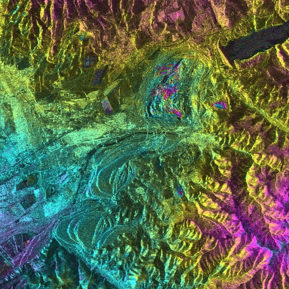
3 Coal mine in Uzbekistan


4 vertical displacement 0.5 km B A m elevation meters displacement A B latitude Mud volcano in Azerbaijan meters 49.42


5 3.775e e e e Tunnels of LA
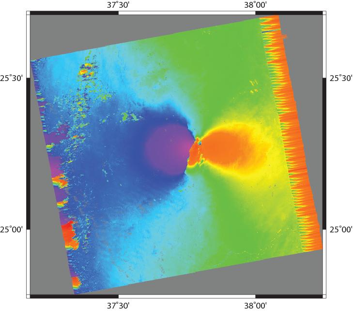
6 Overview Given an interferogram(s) - usually need to convert to useful units - convert phase to m, cm, mm, furlongs, etc - we know radar wavelength - we know geometry Requires unwrapping - often filter beforehand - unwrapping not trivial Saudi 7/1/08-8/19/08 ALOS Bperp 20 m
7
8 Filtering objective: improve signal-to-noise static - usually lowpass - convolve with set of filter coefficients (boxcar, Gaussian, etc) adaptive - Goldstein and Werner [1998] spectral filter. - effective but can significantly change the structure of the interferogram [Baran et al, 2003]
9 adaptive filter - filter parameter vary depending of properties of each patch H(u,v) = (S{ Z(u,v) } a )(Z(u,v)) Z(u,v) Fourier spectrum of small 2D patch of complex interferogram (perhaps 32 by 32 pixels) S smoothing (e.g. 3 by 3 pixels) H output α exponent (a = 0, no filter, a > 0 filters) - take Fourier of small patch - raise spectrum to power - inverse FFT - results depends on noise and phase! - Baran et al [2003] use α = 1 γ where γ is the coherence
10 Phase unwrapping* overview A) The problem and some answers** 1. Global solutions a) Transforms b) Matrix 2. Local solutions a) Residues b) Quality 3. Network methods B) Reduce or avoid the problem*** A. Filter B. Model phase beforehand *phase unwrapping problems occurs in other areas as well **many algorithms exist; I present only selected ones. *** this is the best strategy in many cases.
11 Phase unwrapping Assume that we have two signals taken at different times: g 1 = a 1 exp(i4πr 1 /λ) g 2 = a 2 exp(i4πr 2 /λ) a1,a2 = complex reflectivity R1, R2 is range from antenna to surface λ = wavelength At a given point, assume a 1 = a 2 = a (g1)(g2*) = (a 2 )exp[i4π(r 1 -R 2 )] = s(t) The phase of this function is proportional to the effective difference in range, which in turn depends on satellite geometry, topography, soil moisture, or maybe even deformation.
12 Extracting the phase We can get only the wrapped phase* ψ(t) = arctan(i(s(t)),r(s(t))) where π < ψ(t) < π We would like the continuous phase. This appears simple. Look for 2π jumps and then add the appropriate multiple of 2π. If the data are good, phase unwrapping is straightforward We could take derivative in complex version (e.g. Sandwell & Price)
13 Two major problems Aliasing. True phase changes by more than 1 cycle (π radian) between samples. Caused by long baselines, steep topography, or high deformation. Noise and/or gaps in the data. Changes in the surface may decorrelate the signal and introduce noise.
14 For 2D data the same problems exist. How to unwrap? Want to find a function that when wrapped, is close to the observed data (whatever close is). Two basic approaches: Global methods that attempt to unwrap all pixels simultaneously. Local methods that solve along a path. Note that the correlation data allows some estimation of how good the phase data is (maybe also amplitude/phase stability over time?)
15 Global We want to find the function whose local derivatives match the observed derivatives given some measure : e p = [(φ i+1, k -φ i,k ) Δ x i,k ]p + [(φ ik+1 - φ ik )-Δ y ik )]p P = exponent φ = unknown function Δ = derivatives of the observed phase (can calculate from the complex phase). For p = 2, this is equivalent to the discrete version of Poisson s Equation Two basic ways to solve: Transform : FFT, DCT (discrete cosine transformbe careful with b.c. s) Matrix (will allow weighting but now nonlinear and requires iteration) Can vary the exponent (i.e. don t have to use 2)
16 An elegant and easy solution, but. doesn t work very well with noise. Tend to underestimate true phase when noise exists (it s a least-square fit). No easy way to add weighting short of iterating. Matrix methods solve: Ax = b With weighting: WAx = Wb W = matrix of weights A = operator B = set of observed phase values x = unknown function These work better than the transform methods but like all global solutions, do not provide a good fit anywhere.
17 Transform-based methods Fast, but do not allow weighting FFT requires periodic conditions and extension of data. Apply 2D Fourier transform: ρ i, k = x x y y ( Δi, k Δi 1, k ) + ( Δi, k Δi, k 1) Φ m, n = 2cos( πm / P m, n M ) + 2cos( πn / N) 4 Φ = Fourier transform of φ P = Fourier transform of ρ 1. Calculate the ρ i,k from the data 2. Calculate the 2D FFT of ρ i,k 3. Calculate Φ m,n from the transformed ρ i,k 4. Do inverse FFT
18 Local (path following) Similar to the 1D approach 1.) Calculate the differences of the wrapped phase. 2.) Wrap the differences. 3.) Set the value of the first value. 3.) Integrate along all values. Do this along a line throughout 2D area (in a zigzag back and forth along the rows, for example) Works great if there is no noise. With noise: 1) An error near the start of the path propagates along the whole path. 2) Answer may vary with path. 3) Need to identify bad pixels. How?
19 For 2D data integration around a closed loop should sum to zero. (in cycles multiply by 2π to get radians) Δ 4 Δ 1 = -0.2 Δ 2 = -0.1 Δ 3 = 0.4 Δ 4 = -0.1 Sum: 0.0 Δ 1 Δ 2 Δ
20 However, we know that topographic surfaces are conservative Any points that violate this should be avoided. These points are known as residues. Any integration path that circles a residue will contain errors need to make branch cuts A residue is a property of phase differences, not a single pixel. can be positive or negative
21 1.) Identify all residues in data (marked as the upper left pixel) 2) Draw lines (branch cuts) between them to eliminate possibility of drawing a circle around a residue. 3) Unwrap the rest of the data *Note: residues can be positive or negative. A positive linked to a negative cancel each other out. This is the basis of the Goldstein approach, (used in Roi_pac). Often, poor data (with low correlation is masked out beforehand)
22 Goldstein* algorithm [different from filtering] 1.) Calculate correlation for phase data. 2.) Mask out all areas with correlation less than a certain threshold value. 3.) Go through all pixels and identify residue locations (upper left of 4 pixels). 4) Start with first residue, look for nearest residue. Draw a line of marked pixels between the two. - if residues cancel, go to next residue and start new tree - otherwise, look for next nearest and draw line - can also cancel by connecting to edge. - connected lines are called a tree. 5) path-integrate along remaining pixels.
23 Negative residue - + Branch cut Positive residue 1) start + 2) search in box - + 3) find second residue 4) connect with branch cut
24 Fast Need to start integration (seed point) in area of good data. Residues often lie in areas of layover. Regions can get isolated from each other with dramatically different phase (by multiples of 2π). Some implementations allows manual connecting of regions. Some implementations allow preprocessing to connect closely-spaced opposite residues (dipoles) first. Minimizes distance between residues; does not minimize number of cycles needed to unwrap. A similar algorithm uses quality rather than residues to define.

25 if it doesn t work Lopez-Quiroz et al, [2009,]
26 Flynn s minimum discontinuity 1) Identify lines of discontinuity (fringe lines) 1) Difference between adjacent pixels > π 2) Magnitude of discontinuity defined by number of multiples of 2π needed to fix. 2) Add multiples of 2π to eliminate lines of discontinuities that form loops. 3) Checks to see if operation creates more discontinuities than removes. 4) Continues in an iterative fashion. 5) At end, no more discontinuities can be removed without adding more. 6) Complicated algorithm (i.e. I looked at it and got a headache) Comments: Slow. Masking helps. Can be appended after other unwrapping algorithms. Good to run Goldstein or quality first, then Flynn.
27 Chen and Zebker s (2000) [SNAPHU] 1) A branch-cut algorithm minimizes the total discontinuity length (L 0 ). 2) Flynn yields a L 1 solution. 3) Least-squares yield an L 2 solution. C&Z claim low norms are best. For interferograms corrupted by noise, L 0 and L 1 algorithms yield similar solutions. For layover, where discontinuities separate severe phase gradients, L 1 algorithms do not do well.
28 Residues caused by topographic layover with illumination from one side Good L0 Bad L1 Negative residue Positive residue
29 The ultimate L0 algorithm would minimize the total cut length. C&Z show that the L0 problem is equivalent to an NP-complete problem and therefore hard for efficient algorithms to solve completely. Therefore, the L0 branch-cut algorithm is a good place to start. Major problem is that cuts close on themselves. Total tree length is upper bound on total discontinuity length.
30 Modifications 1) Minimum span (MST) 1) Define cuts so that a tree cannot connect to itself. 2) Connect all trees. 3) Use knowledge of residues to guide integration. 4) Complete unwrapping 2) Minimum cost (MCF) 1) Uses flow to reduce cycles
31 Removing topography (and deformation) If an accurate topographic model is available, then many of these problems can be alleviated during calculation of the interferogram. Reduce need for unwrapping. Deformation model can also be included. Can be done iteratively. Also true for large deformations (maybe done in an iterative fashion)
32 The future: persistent scatterers 3D unwrapping The PS technique leads to widely spaced pixels. Phase relationships between these pixels may be challenging to define. If we have a time series of interferograms, phase unwrapping becomes a 3d problem.
33 Geocoding: One method Fly satellite along path with known orbit Find point (azimuth) of nearest approach to each DEM pixel with known latitude and longitude. Distance to point yields range This provides a mapping of range, azimith to latitude, longitude.
34 sometimes filtering is not necessary Saudi 7/1/08-8/19/08 ALOS Bperp 20 m (low coherence masked out)
35 Geocoding
36 want to eliminate fringes
*or what to do when your interferogram looks like this
 Filtering, unwrapping, and geocoding* Rob Mellors Eric Lindsey, Ph.D. Kurt Feigl Wrapping your head around the problem Wrapping operator Residues using SNAPHU in GMTSAR Eric Lindsey interpolation Xiaohua
PSI Precision, accuracy and validation aspects
 PSI Precision, accuracy and validation aspects Urs Wegmüller Charles Werner Gamma Remote Sensing AG, Gümligen, Switzerland, wegmuller@gamma-rs.ch Contents Aim is to obtain a deeper understanding of what
FAST SOLUTION OF PHASE UNWRAPPING PARTIAL DIFFERENTIAL EQUATION USING WAVELETS
 Tenth MSU Conference on Differential Equations and Computational Simulations. Electronic Journal of Differential Equations, Conference 23 (2016), pp. 119 129. ISSN: 1072-6691. URL: http://ejde.math.txstate.edu
Scene Matching on Imagery
 Scene Matching on Imagery There are a plethora of algorithms in existence for automatic scene matching, each with particular strengths and weaknesses SAR scenic matching for interferometry applications
fraction of Nyquist
 differentiator 4 2.1.2.3.4.5.6.7.8.9 1 1 1/integrator 5.1.2.3.4.5.6.7.8.9 1 1 gain.5.1.2.3.4.5.6.7.8.9 1 fraction of Nyquist Figure 1. (top) Transfer functions of differential operators (dotted ideal derivative,
Sentinel-1 Toolbox. Interferometry Tutorial Issued March 2015 Updated August Luis Veci
 Sentinel-1 Toolbox Interferometry Tutorial Issued March 2015 Updated August 2016 Luis Veci Copyright 2015 Array Systems Computing Inc. http://www.array.ca/ http://step.esa.int Interferometry Tutorial The
Interferometry Tutorial with RADARSAT-2 Issued March 2014 Last Update November 2017
 Sentinel-1 Toolbox with RADARSAT-2 Issued March 2014 Last Update November 2017 Luis Veci Copyright 2015 Array Systems Computing Inc. http://www.array.ca/ http://step.esa.int with RADARSAT-2 The goal of
Repeat-pass SAR Interferometry Experiments with Gaofen-3: A Case Study of Ningbo Area
 Repeat-pass SAR Interferometry Experiments with Gaofen-3: A Case Study of Ningbo Area Tao Zhang, Xiaolei Lv, Bing Han, Bin Lei and Jun Hong Key Laboratory of Technology in Geo-spatial Information Processing
Interferometric processing. Rüdiger Gens
 Rüdiger Gens Why InSAR processing? extracting three-dimensional information out of a radar image pair covering the same area digital elevation model change detection 2 Processing chain 3 Processing chain
Sentinel-1 Toolbox. TOPS Interferometry Tutorial Issued May 2014
 Sentinel-1 Toolbox TOPS Interferometry Tutorial Issued May 2014 Copyright 2015 Array Systems Computing Inc. http://www.array.ca/ https://sentinel.esa.int/web/sentinel/toolboxes Interferometry Tutorial
Individual Interferograms to Stacks!
 Individual Interferograms to Stacks! Piyush Agram! Jet Propulsion Laboratory!! Jun 29, 2015! @UNAVCO! Thanks to my colleagues from JPL, Caltech, Stanford University and from all over the world for providing
Individual Interferograms to Stacks
 Individual Interferograms to Stacks Piyush Agram Jet Propulsion Laboratory Aug 1, 2016 @UNAVCO Thanks to my colleagues from JPL, Caltech, Stanford University and from all over the world for providing images
NOISE SUSCEPTIBILITY OF PHASE UNWRAPPING ALGORITHMS FOR INTERFEROMETRIC SYNTHETIC APERTURE SONAR
 Proceedings of the Fifth European Conference on Underwater Acoustics, ECUA 000 Edited by P. Chevret and M.E. Zakharia Lyon, France, 000 NOISE SUSCEPTIBILITY OF PHASE UNWRAPPING ALGORITHMS FOR INTERFEROMETRIC
Synthetic Aperture Radar Interferometry (InSAR)
") CEE 6100 / CSS 6600 Remote Sensing Fundamentals 1 Synthetic Aperture Radar Interferometry (InSAR) Adapted from and the ESA Interferometric SAR overview by Rocca et al. http://earth.esa.int/workshops/ers97/program-details/speeches/rocca-et-al/
CEE 6100 / CSS 6600 Remote Sensing Fundamentals 1 Synthetic Aperture Radar Interferometry (InSAR) Adapted from and the ESA Interferometric SAR overview by Rocca et al. http://earth.esa.int/workshops/ers97/program-details/speeches/rocca-et-al/
A RESIDUE-PAIRING ALOGRITHM FOR INSAR PHASE UNWRAPPING
 Progress In Electromagnetics Research, PIER 95, 341 354, 2009 A RESIDUE-PAIRING ALOGRITHM FOR INSAR PHASE UNWRAPPING C. Li and D. Y. Zhu Department of Electronic Engineering Nanjing University of Aeronautics
2003 IEEE. Personal use of this material is permitted. However, permission to reprint/republish this material for advertising or promotional purposes
 2003 IEEE. Personal use of this material is permitted. However, permission to reprint/republish this material for advertising or promotional purposes or for creating new collective works for resale or
Do It Yourself 8. Polarization Coherence Tomography (P.C.T) Training Course
 Training Course") Do It Yourself 8 Polarization Coherence Tomography (P.C.T) Training Course 1 Objectives To provide a self taught introduction to Polarization Coherence Tomography (PCT) processing techniques to enable
Do It Yourself 8 Polarization Coherence Tomography (P.C.T) Training Course 1 Objectives To provide a self taught introduction to Polarization Coherence Tomography (PCT) processing techniques to enable
Sentinel-1 InSAR Phase Unwrapping using S1TBX and SNAPHU
 Making remote-sensing data accessible since 1991 Sentinel-1 InSAR Phase Unwrapping using S1TBX and SNAPHU Adapted from the European Space Agency s STEP community platform In this document you will find:
Multi Baseline Interferometric Techniques and
 Pagina 1 di 11 FRINGE 96 Multi Baseline Interferometric Techniques and Applications A.Ferretti, A. Monti Guarnieri, C.Prati and F.Rocca Dipartimento di Elettronica e Informazione (DEI) Politecnico di Milano
Lateral Ground Movement Estimation from Space borne Radar by Differential Interferometry.
 Lateral Ground Movement Estimation from Space borne Radar by Differential Interferometry. Abstract S.Sircar 1, 2, C.Randell 1, D.Power 1, J.Youden 1, E.Gill 2 and P.Han 1 Remote Sensing Group C-CORE 1
Interferometric SAR Processing
 Documentation - Theory Interferometric SAR Processing Version 1.0 November 2007 GAMMA Remote Sensing AG, Worbstrasse 225, CH-3073 Gümligen, Switzerland tel: +41-31-951 70 05, fax: +41-31-951 70 08, email:
A Correlation Test: What were the interferometric observation conditions?
 A Correlation Test: What were the interferometric observation conditions? Correlation in Practical Systems For Single-Pass Two-Aperture Interferometer Systems System noise and baseline/volumetric decorrelation
Vivekananda. Collegee of Engineering & Technology. Question and Answers on 10CS762 /10IS762 UNIT- 5 : IMAGE ENHANCEMENT.
 Vivekananda Collegee of Engineering & Technology Question and Answers on 10CS762 /10IS762 UNIT- 5 : IMAGE ENHANCEMENT Dept. Prepared by Harivinod N Assistant Professor, of Computer Science and Engineering,
A STATISTICAL-COST APPROACH TO UNWRAPPING THE PHASE OF INSAR TIME SERIES
 A STATISTICAL-COST APPROACH TO UNWRAPPING THE PHASE OF INSAR TIME SERIES Andrew Hooper Delft Institute of Earth Observation and Space Systems, Delft University of Technology, Delft, Netherlands, Email:
Radar Coherent Backscatter!
 Radar Coherent Backscatter! Pixels in a radar image are a complex phasor representation of the coherent backscatter from the resolution element on the ground and the propagation phase delay! Interferometric
Persistent Scatterer InSAR for Crustal Deformation Analysis, with Application to Volcán Alcedo, Galápagos
 JOURNAL OF GEOPHYSICAL RESEARCH, VOL. XXX, XXXX, DOI:1.19/6JB4763, 7 Persistent Scatterer InSAR for Crustal Deformation Analysis, with Application to Volcán Alcedo, Galápagos A. Hooper Department of Geophysics,
The 2017 InSAR package also provides support for the generation of interferograms for: PALSAR-2, TanDEM-X
 Technical Specifications InSAR The Interferometric SAR (InSAR) package can be used to generate topographic products to characterize digital surface models (DSMs) or deformation products which identify
In addition, the image registration and geocoding functionality is also available as a separate GEO package.
 GAMMA Software information: GAMMA Software supports the entire processing from SAR raw data to products such as digital elevation models, displacement maps and landuse maps. The software is grouped into
Operational process interferometric for the generation of a digital model of ground Applied to the couple of images ERS-1 ERS-2 to the area of Algiers
 Operational process interferometric for the generation of a digital model of ground Applied to the couple of images ERS-1 ERS-2 to the area of Algiers F. Hocine, M.Ouarzeddine, A. elhadj-aissa,, M. elhadj-aissa,,
An InSAR phase unwrapping algorithm with the phase discontinuity compensation
 An InSAR phase unwrapping algorithm with the phase discontinuity compensation Andrey V. Sosnovsky and Victor G. Kobernichenko Ural Federal University, Yekaterinburg, Mira st., 19, Russia, sav83@e1.ru Abstract.
InSAR Operational and Processing Steps for DEM Generation
 InSAR Operational and Processing Steps for DEM Generation By F. I. Okeke Department of Geoinformatics and Surveying, University of Nigeria, Enugu Campus Tel: 2-80-5627286 Email:francisokeke@yahoo.com Promoting
ICE VELOCITY measurements are fundamentally important
 102 IEEE GEOSCIENCE AND REMOTE SENSING LETTERS, VOL. 4, NO. 1, JANUARY 2007 Synergistic Fusion of Interferometric and Speckle-Tracking Methods for Deriving Surface Velocity From Interferometric SAR Data
SAR Interferometry. Dr. Rudi Gens. Alaska SAR Facility
 SAR Interferometry Dr. Rudi Gens Alaska SAR Facility 2 Outline! Relevant terms! Geometry! What does InSAR do?! Why does InSAR work?! Processing chain " Data sets " Coregistration " Interferogram generation
Optimised corrections for finite-difference modelling in two dimensions
 Optimized corrections for 2D FD modelling Optimised corrections for finite-difference modelling in two dimensions Peter M. Manning and Gary F. Margrave ABSTRACT Finite-difference two-dimensional correction
The STUN algorithm for Persistent Scatterer Interferometry
 [1/27] The STUN algorithm for Persistent Scatterer Interferometry Bert Kampes, Nico Adam 1. Theory 2. PSIC4 Processing 3. Conclusions [2/27] STUN Algorithm Spatio-Temporal Unwrapping Network (STUN) 4 1D
Ground Subsidence Monitored by L-band Satellite Radar. Interferometry
 Ground Subsidence Monitored by L-band Satellite Radar Interferometry Hsing-Chung Chang, Ming-han Chen, Lijiong Qin, Linlin Ge and Chris Rizos Satellite Navigation And Positioning Group School of Surveying
3 - SYNTHETIC APERTURE RADAR (SAR) SUMMARY David Sandwell, SIO 239, January, 2008
 SUMMARY David Sandwell, SIO 239, January, 2008") 1 3 - SYNTHETIC APERTURE RADAR (SAR) SUMMARY David Sandwell, SIO 239, January, 2008 Fraunhoffer diffraction To understand why a synthetic aperture in needed for microwave remote sensing from orbital altitude
1 3 - SYNTHETIC APERTURE RADAR (SAR) SUMMARY David Sandwell, SIO 239, January, 2008 Fraunhoffer diffraction To understand why a synthetic aperture in needed for microwave remote sensing from orbital altitude
InSAR Data Coherence Estimation Using 2D Fast Fourier Transform
 InSAR Data Coherence Estimation Using 2D Fast Fourier Transform Andrey V. Sosnovsky 1, Viktor G. Kobernichenko 1, Nina S. Vinogradova 1, Odhuu Tsogtbaatar 1,2 1 Ural Federal University, Yekaterinburg,
SAOCOM 1A INTERFEROMETRIC ERROR MODEL AND ANALYSIS
 SAOCOM A INTERFEROMETRIC ERROR MODEL AND ANALYSIS Pablo Andrés Euillades (), Leonardo Daniel Euillades (), Mario Azcueta (), Gustavo Sosa () () Instituto CEDIAC FI UNCuyo & CONICET, Centro Universitario,
Precise orbits and accurate timing simplifies software and enables seamless mosaicing. Geometric validation of ERS, Envisat, and ALOS.
 Geometric Calibration of GMTSAR Processing Software Using Corner Reflectors at Pinon Flat David Sandwell, UCSD/SIO CEOS Cal/Val Workshop, November 8, 2011 What is GMTSAR? Precise orbits and accurate timing
Results of UAVSAR Airborne SAR Repeat-Pass Multi- Aperture Interferometry
 Results of UAVSAR Airborne SAR Repeat-Pass Multi- Aperture Interferometry Bryan Riel, Ron Muellerschoen Jet Propulsion Laboratory, California Institute of Technology 2011 California Institute of Technology.
GAMMA Interferometric Point Target Analysis Software (IPTA): Users Guide
: Users Guide") GAMMA Interferometric Point Target Analysis Software (IPTA): Users Guide Contents User Handbook Introduction IPTA overview Input data Point list generation SLC point data Differential interferogram point
GAMMA Interferometric Point Target Analysis Software (IPTA): Users Guide Contents User Handbook Introduction IPTA overview Input data Point list generation SLC point data Differential interferogram point
Generalized Network Flow Programming
 Appendix C Page Generalized Network Flow Programming This chapter adapts the bounded variable primal simplex method to the generalized minimum cost flow problem. Generalized networks are far more useful
INTERFEROMETRIC MULTI-CHROMATIC ANALYSIS OF HIGH RESOLUTION X-BAND DATA
 INTERFEROMETRIC MULTI-CHROMATIC ANALYSIS OF HIGH RESOLUTION X-BAND DATA F. Bovenga (1), V. M. Giacovazzo (1), A. Refice (1), D.O. Nitti (2), N. Veneziani (1) (1) CNR-ISSIA, via Amendola 122 D, 70126 Bari,
MULTI-TEMPORAL INTERFEROMETRIC POINT TARGET ANALYSIS
 MULTI-TEMPORAL INTERFEROMETRIC POINT TARGET ANALYSIS U. WEGMÜLLER, C. WERNER, T. STROZZI, AND A. WIESMANN Gamma Remote Sensing AG. Thunstrasse 130, CH-3074 Muri (BE), Switzerland wegmuller@gamma-rs.ch,
Three-dimensional digital elevation model of Mt. Vesuvius from NASA/JPL TOPSAR
 Cover Three-dimensional digital elevation model of Mt. Vesuvius from NASA/JPL TOPSAR G.ALBERTI, S. ESPOSITO CO.RI.S.T.A., Piazzale V. Tecchio, 80, I-80125 Napoli, Italy and S. PONTE Department of Aerospace
Edge detection. Convert a 2D image into a set of curves. Extracts salient features of the scene More compact than pixels
 Edge Detection Edge detection Convert a 2D image into a set of curves Extracts salient features of the scene More compact than pixels Origin of Edges surface normal discontinuity depth discontinuity surface
Phase demodulation of interferograms with open or closed fringes
 Phase demodulation of interferograms with open or closed fringes Mariano Rivera Centro de Investigacion en Matematicas A.C., Apdo. Postal 402, Guanajuato, Gto. Mexico 36000 Abstract Analysis of fringe
Concept and methodology of SAR Interferometry technique
 Concept and methodology of SAR Interferometry technique March 2016 Differen;al SAR Interferometry Young s double slit experiment - Construc;ve interference (bright) - Destruc;ve interference (dark) http://media-2.web.britannica.com/eb-media/96/96596-004-1d8e9f0f.jpg
ERS AND ENVISAT DIFFERENTIAL SAR INTERFEROMETRY FOR SUBSIDENCE MONITORING
 ERS AND ENVISAT DIFFERENTIAL SAR INTERFEROMETRY FOR SUBSIDENCE MONITORING Urs Wegmüller 1, Tazio Strozzi 1, and Luigi Tosi 2 1 Gamma Remote Sensing, Thunstrasse 130, CH-3074 Muri b. Bern, Switzerland Tel:
Digital Image Processing. Image Enhancement in the Frequency Domain
 Digital Image Processing Image Enhancement in the Frequency Domain Topics Frequency Domain Enhancements Fourier Transform Convolution High Pass Filtering in Frequency Domain Low Pass Filtering in Frequency
DETECTION AND QUANTIFICATION OF ROCK GLACIER. DEFORMATION USING ERS D-InSAR DATA
 DETECTION AND QUANTIFICATION OF ROCK GLACIER DEFORMATION USING ERS D-InSAR DATA Lado W. Kenyi 1 and Viktor Kaufmann 2 1 Institute of Digital Image Processing, Joanneum Research Wastiangasse 6, A-8010 Graz,
Interferometry Module for Digital Elevation Model Generation
 Interferometry Module for Digital Elevation Model Generation In order to fully exploit processes of the Interferometry Module for Digital Elevation Model generation, the European Space Agency (ESA) has
An empirical model for interferometric coherence
 An empirical model for interferometric coherence Chaabane F. a, Tupin F. b and Maître H. b a URISA-SUP COM, 3.5 route de Raoued, 283 Ariana, Tunisie b GET-Télécom-Paris - CNRS URA 82, 46 rue Barrault,
IMPROVING DEMS USING SAR INTERFEROMETRY. University of British Columbia. ABSTRACT
 IMPROVING DEMS USING SAR INTERFEROMETRY Michael Seymour and Ian Cumming University of British Columbia 2356 Main Mall, Vancouver, B.C.,Canada V6T 1Z4 ph: +1-604-822-4988 fax: +1-604-822-5949 mseymour@mda.ca,
Digital Image Processing. Lecture 6
 Digital Image Processing Lecture 6 (Enhancement in the Frequency domain) Bu-Ali Sina University Computer Engineering Dep. Fall 2016 Image Enhancement In The Frequency Domain Outline Jean Baptiste Joseph
Overview. Spectral Processing of Point- Sampled Geometry. Introduction. Introduction. Fourier Transform. Fourier Transform
 Overview Spectral Processing of Point- Sampled Geometry Introduction Fourier transform Spectral processing pipeline Spectral filtering Adaptive subsampling Summary Point-Based Computer Graphics Markus
DIGITAL ELEVATION MODEL GENERATION FROM INTERFEROMETRIC SYNTHETIC APERTURE RADAR USING MULTI-SCALE METHOD
 DIGITAL ELEVATION MODEL GENERATION FROM INTERFEROMETRIC SYNTHETIC APERTURE RADAR USING MULTI-SCALE METHOD Jung Hum Yu 1, Linlin Ge, Chris Rizos School of Surveying and Spatial Information Systems University
Measuring Horizontal Ground Deformation Using Optical Satellite Images Part 1 of 2
 Measuring Horizontal Ground Deformation Using Optical Satellite Images Part 1 of 2 Sébastien Leprince California Institute of Technology Ge 167 Lecture Notes May 12, 2009 Overview Objective: Monitoring
convolution shift invariant linear system Fourier Transform Aliasing and sampling scale representation edge detection corner detection
 COS 429: COMPUTER VISON Linear Filters and Edge Detection convolution shift invariant linear system Fourier Transform Aliasing and sampling scale representation edge detection corner detection Reading:
Collaborative Sparsity and Compressive MRI
 Modeling and Computation Seminar February 14, 2013 Table of Contents 1 T2 Estimation 2 Undersampling in MRI 3 Compressed Sensing 4 Model-Based Approach 5 From L1 to L0 6 Spatially Adaptive Sparsity MRI
SMALL SCALE SURFACE DEFORMATION MONITORING IN MINING REGIONS USING DIFFERENTIAL RADAR INTERFEROMETRY.
 Proceedings, 11 th FIG Symposium on Deformation Measurements, Santorini, Greece, 003. SMALL SCALE SURFACE DEFORMATION MONITORING IN MINING REGIONS USING DIFFERENTIAL RADAR INTERFEROMETRY. Ireneusz Baran
A COMPARATIVE STUDY ON THE PERFORMANCE OF THE INSAR PHASE FILTERING APPROCHES IN THE SPATIAL AND THE WAVELET DOMAINS
 A COMPARATIVE STUDY ON THE PERFORMANCE OF THE INSAR PHASE FILTERING APPROCHES IN THE SPATIAL AND THE WAVELET DOMAINS Wajih Ben Abdallah 1 and Riadh Abdelfattah 1,2 1 Higher School Of Communications of
IDENTIFICATION OF THE LOCATION PHASE SCREEN OF ERS-ENVISAT PERMANENT SCATTERERS
 IDENTIFICATION OF THE LOCATION PHASE SCREEN OF ERS-ENVISAT PERMANENT SCATTERERS M. Arrigoni (1), C. Colesanti (1), A. Ferretti (2), D. Perissin (1), C. Prati (1), F. Rocca (1) (1) Dipartimento di Elettronica
Lecture 15: Segmentation (Edge Based, Hough Transform)
") Lecture 15: Segmentation (Edge Based, Hough Transform) c Bryan S. Morse, Brigham Young University, 1998 000 Last modified on February 3, 000 at :00 PM Contents 15.1 Introduction..............................................
Lecture 15: Segmentation (Edge Based, Hough Transform) c Bryan S. Morse, Brigham Young University, 1998 000 Last modified on February 3, 000 at :00 PM Contents 15.1 Introduction..............................................
Filterbanks and transforms
 Filterbanks and transforms Sources: Zölzer, Digital audio signal processing, Wiley & Sons. Saramäki, Multirate signal processing, TUT course. Filterbanks! Introduction! Critical sampling, half-band filter!
Measuring Ground Deformation using Optical Imagery
 Measuring Ground Deformation using Optical Imagery Sébastien Leprince California Institute of Technology, USA October 29, 2009 Keck Institute for Space Studies Workshop Measuring Horizontal Ground Displacement,
Computer Vision I. Announcements. Fourier Tansform. Efficient Implementation. Edge and Corner Detection. CSE252A Lecture 13.
 Announcements Edge and Corner Detection HW3 assigned CSE252A Lecture 13 Efficient Implementation Both, the Box filter and the Gaussian filter are separable: First convolve each row of input image I with
RADARGRAMMETRY AND INTERFEROMETRY SAR FOR DEM GENERATION
 RADARGRAMMETRY AND INTERFEROMETRY SAR FOR DEM GENERATION Jung Hum Yu 1, Xiaojing Li, Linlin Ge, and Hsing-Chung Chang School of Surveying and Spatial Information Systems University of New South Wales,
Image Transformation Techniques Dr. Rajeev Srivastava Dept. of Computer Engineering, ITBHU, Varanasi
 Image Transformation Techniques Dr. Rajeev Srivastava Dept. of Computer Engineering, ITBHU, Varanasi 1. Introduction The choice of a particular transform in a given application depends on the amount of
Chapter 11 Image Processing
 Chapter Image Processing Low-level Image Processing Operates directly on a stored image to improve or enhance it. Stored image consists of a two-dimensional array of pixels (picture elements): Origin (0,
Playa del Rey, California InSAR Ground Deformation Monitoring
 Document Title Playa del Rey, California InSAR Ground Deformation Monitoring Prepared By: (signature / date) Ref.: RV-14524 Project Manager: xxxxxx July 13, 2009 SUBMITTED TO: ATTN: Mr. Rick Gailing Southern
Assignment 3: Edge Detection
 Assignment 3: Edge Detection - EE Affiliate I. INTRODUCTION This assignment looks at different techniques of detecting edges in an image. Edge detection is a fundamental tool in computer vision to analyse
Coherence Based Polarimetric SAR Tomography
 I J C T A, 9(3), 2016, pp. 133-141 International Science Press Coherence Based Polarimetric SAR Tomography P. Saranya*, and K. Vani** Abstract: Synthetic Aperture Radar (SAR) three dimensional image provides
Interferometric Synthetic-Aperture Radar (InSAR) Basics
 Basics") Interferometric Synthetic-Aperture Radar (InSAR) Basics 1 Outline SAR limitations Interferometry SAR interferometry (InSAR) Single-pass InSAR Multipass InSAR InSAR geometry InSAR processing steps Phase
Interferometric Synthetic-Aperture Radar (InSAR) Basics 1 Outline SAR limitations Interferometry SAR interferometry (InSAR) Single-pass InSAR Multipass InSAR InSAR geometry InSAR processing steps Phase
GP265 /EE 355 Homework 8 (Final project 2)
") GP265 /EE 355 Homework 8 (Final project 2) March 14, 2018 1. Display interferogram phase 2. Calculate the curved earth fringe pattern and subtract it from the interferogram phase. First I compute the slant
GP265 /EE 355 Homework 8 (Final project 2) March 14, 2018 1. Display interferogram phase 2. Calculate the curved earth fringe pattern and subtract it from the interferogram phase. First I compute the slant
DINSAR: Differential SAR Interferometry
 DINSAR: Differential SAR Interferometry Fabio Rocca 1 SAR interferometric phase: ground motion contribution If a scatterer on the ground slightly changes its relative position in the time interval between
A Comparison of ALOS PALSAR-2 Calibration Data by Using External DEM
 CEOS SAR Calibration and Validation Workshop 2016 A Comparison of ALOS PALSAR-2 Calibration Data by Using External DEM Tokyo Denki University, Japan, 7 th -9 th September 2016 *Choen KIM College of Forest
WIDE BASELINE INTERFEROMETRY WITH VERY LOW RESOLUTION SAR SYSTEMS
 1 of 25 26/03/2008 22.35 ne previo WIDE BASELINE INTERFEROMETRY WITH VERY LOW RESOLUTION SAR SYSTEMS Abstract: A. Monti Guarnieri, C. Prati, F. Rocca and Y-L. Desnos (*) Dipartimento di Elettronica e Informazione
Airborne Differential SAR Interferometry: First Results at L-Band
 1516 IEEE TRANSACTIONS ON GEOSCIENCE AND REMOTE SENSING, VOL. 41, NO. 6, JUNE 2003 Airborne Differential SAR Interferometry: First Results at L-Band Andreas Reigber, Member, IEEE, and Rolf Scheiber Abstract
Playa del Rey, California InSAR Ground Deformation Monitoring
 Playa del Rey, California InSAR Ground Deformation Monitoring Master Document Ref.: RV-14524 July 13, 2009 SUBMITTED TO: ATTN: Mr. Rick Gailing Southern California Gas Company 555 W. Fifth Street (Mail
Biomedical Image Analysis. Spatial Filtering
 Biomedical Image Analysis Contents: Spatial Filtering The mechanics of Spatial Filtering Smoothing and sharpening filters BMIA 15 V. Roth & P. Cattin 1 The Mechanics of Spatial Filtering Spatial filter:
Motion compensation and the orbit restitution
 InSA R Contents Introduction and objectives Pi-SAR Motion compensation and the orbit restitution InSAR algorithm DEM generation Evaluation Conclusion and future work Introduction and Objectives L-band
Correction and Calibration 2. Preprocessing
 Correction and Calibration Reading: Chapter 7, 8. 8.3 ECE/OPTI 53 Image Processing Lab for Remote Sensing Preprocessing Required for certain sensor characteristics and systematic defects Includes: noise
Chapter 3: Intensity Transformations and Spatial Filtering
 Chapter 3: Intensity Transformations and Spatial Filtering 3.1 Background 3.2 Some basic intensity transformation functions 3.3 Histogram processing 3.4 Fundamentals of spatial filtering 3.5 Smoothing
2-PASS DIFFERENTIAL INTERFEROMETRY IN THE AREA OF THE SLATINICE ABOVE- LEVEL DUMP. Milan BOŘÍK 1
 2-PASS DIFFERENTIAL INTERFEROMETRY IN THE AREA OF THE SLATINICE ABOVE- LEVEL DUMP Milan BOŘÍK 1 1 Department of Mathematics, Faculty of Civil Engineering, Czech Technical University in Prague, Thákurova
Texture. Outline. Image representations: spatial and frequency Fourier transform Frequency filtering Oriented pyramids Texture representation
 Texture Outline Image representations: spatial and frequency Fourier transform Frequency filtering Oriented pyramids Texture representation 1 Image Representation The standard basis for images is the set
Texture. Frequency Descriptors. Frequency Descriptors. Frequency Descriptors. Frequency Descriptors. Frequency Descriptors
 Texture The most fundamental question is: How can we measure texture, i.e., how can we quantitatively distinguish between different textures? Of course it is not enough to look at the intensity of individual
1.Some Basic Gray Level Transformations
 1.Some Basic Gray Level Transformations We begin the study of image enhancement techniques by discussing gray-level transformation functions.these are among the simplest of all image enhancement techniques.the
Sparse matrices, graphs, and tree elimination
 Logistics Week 6: Friday, Oct 2 1. I will be out of town next Tuesday, October 6, and so will not have office hours on that day. I will be around on Monday, except during the SCAN seminar (1:25-2:15);
Progress In Electromagnetics Research M, Vol. 14, 15 32, 2010 RECONSTRUCTING HIGH-ACCURACY DEM WITH PRECISE ORBIT DATA AND EXTERNAL DEM
 Progress In Electromagnetics Research M, Vol. 14, 15 32, 2010 RECONSTRUCTING HIGH-ACCURACY DEM WITH PRECISE ORBIT DATA AND EXTERNAL DEM A. Bin School of Marine Sciences Sun Yat-sen University Guangzhou
Evaluation of Two-Dimensional Phase Unwrapping Algorithms for Interferometric Adaptive Optics Utilizing Liquid-Crystal Spatial Light Modulators
 48 The Open Optics Journal, 008,, 48-5 Open Access Evaluation of Two-Dimensional Phase Unwrapping Algorithms for Interferometric Adaptive Optics Utilizing Liquid-Crystal Spatial Light Modulators K.L. Baker
GENERATION OF DEM WITH SUB-METRIC VERTICAL ACCURACY FROM 30 ERS-ENVISAT PAIRS
 GEERATIO OF DEM WITH SUB-METRIC VERTICAL ACCURACY FROM 30 ERS-EVISAT PAIRS C. Colesanti (), F. De Zan (), A. Ferretti (), C. Prati (), F. Rocca () () Dipartimento di Elettronica e Inormazione, Politecnico
Capturing, Modeling, Rendering 3D Structures
 Computer Vision Approach Capturing, Modeling, Rendering 3D Structures Calculate pixel correspondences and extract geometry Not robust Difficult to acquire illumination effects, e.g. specular highlights
LAND SUBSIDENCE WITH SENTINEL-1 using SNAP
 _p TRAINING KIT HAZA03 LAND SUBSIDENCE WITH SENTINEL-1 using SNAP Table of Contents 1 Introduction... 2 2 Training... 2 2.1 Data used... 2 2.2 Software in RUS environment... 2 3 Step by step... 3 3.1 Data
A New Method for Correcting ScanSAR Scalloping Using Forests and inter SCAN Banding Employing Dynamic Filtering
 A New Method for Correcting ScanSAR Scalloping Using Forests and inter SCAN Banding Employing Dynamic Filtering Masanobu Shimada Japan Aerospace Exploration Agency (JAXA), Earth Observation Research Center
Matching and Recognition in 3D. Based on slides by Tom Funkhouser and Misha Kazhdan
 Matching and Recognition in 3D Based on slides by Tom Funkhouser and Misha Kazhdan From 2D to 3D: Some Things Easier No occlusion (but sometimes missing data instead) Segmenting objects often simpler From
Image Processing and Analysis
 Image Processing and Analysis 3 stages: Image Restoration - correcting errors and distortion. Warping and correcting systematic distortion related to viewing geometry Correcting "drop outs", striping and
Adaptive Filtering using Steepest Descent and LMS Algorithm
 IJSTE - International Journal of Science Technology & Engineering Volume 2 Issue 4 October 2015 ISSN (online): 2349-784X Adaptive Filtering using Steepest Descent and LMS Algorithm Akash Sawant Mukesh
InSAR Processing. Sentinel 1 data Case study of subsidence in Mexico city. Marie-Pierre Doin, Cécile Lasserre, Raphaël Grandin, Erwan Pathier
 1 InSAR Processing Sentinel 1 data Case study of subsidence in Mexico city Marie-Pierre Doin, Cécile Lasserre, Raphaël Grandin, Erwan Pathier NSBAS processing chain (based on ROI_PAC): ROI-PAC: Rosen et