Oblique aerial imagery in the praxis: applications and challenges
|
|
|
- Eustacia Phelps
- 6 years ago
- Views:
Transcription

1 ISPRS / EuroSDR Workshop on Oblique aerial cameras sensors and data processing Barcelona, 10 October 2017 Oblique aerial imagery in the praxis: applications and challenges Daniela Poli, Kjersti Moe, Klaus Legat Terra Messflug GmbH, Imst, Austria Vermessung AVT ZT GmbH, Imst, Austria Outline Introduction on TM/AVT Demand in the market Requirements analysis Applications Challenges and open issues Conclusions 2 1


2 Vermessung AVT GmbH Vermessung AVT-ZT-GmbH Mapping company founded in 1970, head-office in Imst, (Tirol, Austria), about 70 employees Activities: cadaster, topography, geodesy, photogrammetry, aerial and terrestrial laser scanning, geoinformation Terra Messflug 100% subsidiary of Vermessung AVT Focused in nadir and oblique aerial digital image acquisition and processing Aircraft: Cessna T303 Optical sensor: UltraCam Eagle Mark2, UltraCam Osprey Prime 3 Introduction AVT in oblique market since 2015 Small, medium and large projects in EU GEOBLy project in collaboration with FBK (Trento, Italy) for: Investigations on sensor geometries, image orientation and 3D surface reconstruction Design and implementation of ad-hoc tool for mapping in oblique images. 4 2


, 10,300 x 7,700 pixels (oblique) SW: UltraMap, Inpho Match-AT, nframes SURE,")
3 VOLTA EU Marie Skłodowska--Curie RISE project: Aerial oblique imagery Introduction Know-how and experience exchange in the field of geospatial data production, investigation and usage between universities, research centres, sensor producers, service providers and mapping agencies Topics: Automatic metric information from images Fusion of heterogeneous data coming from various sensors 2D and 3D geospatial data segmentation Processing of large geospatial datasets in the Cloud 5 Equipment and software Aerial oblique camera: Vexcel Ultracam Osprey Mark3p Focal length: 80mm (nadir) 120 mm (oblique) Oblique sensors tilt: 45 Image size: 13,470 x 8,670 pixels (nadir), 10,300 x 7,700 pixels (oblique) SW: UltraMap, Inpho Match-AT, nframes SURE, Geobly, OrbitGT 6 3
 and nadir +")


4 Selection of results (Imst) Generation of point clouds using only nadir images (N) and nadir + oblique images (N+O). The qualitative comparison of the point clouds and derived automatic models highlights the significant improvement on the reconstruction of the building façades and roof structures when the oblique images are added. 7 N N+O Selection of results (Bergamo) 8 Bergamo, N point cloud 4

 Kundl, textured")
5 Selection of results 9 Bergamo, N+O point cloud Selection of projects (Kundl) Kundl, textured mesh 10 5
6 Customers & Demands Image quality No / low / cheap Nice (well-lit summer photo) Presentation quality Viewer Viewer Format of delivery No delivery to customer No delivery to customer Integration None None Scopes Visual Analysis Height measurement Visual Analysis Mesh Orientation quality 1-5 m (GPS/INS) dm (semi-at-level) 11 Customers & Demands Image quality Presentation quality Format Integration Photogrammetry style (no foliage) Viewer Photogrammetric software As for nadir and/or mesh/clouds To GIS / Photogrammetric software High / medium Interactive Viewer (cloud hosted) Software package Standardized formats (.obj,.tif,.jpg) Full integration to GIS / CAD / other Scopes Measurements Analysis, Measurements, Adaptations / Integration Orientation quality dm / cm (AT-level) dm / cm (AT-level) 12 6
7 Requirements evolution Image quality Geometric accuracy Presentation quality PICTOMETRY USAGE Images for visualization, 3D model texturing, inspections PHOTOGRAMMETRIC USAGE Products for digitalization and mapping, pixel accuracy VR USAGE Geospatial data for 3D modelling, automatic information extraction, editing, rendering 13 Requirements for Exploitation sw Accuracy Web publishing Cloud hosting Automation Sharing Velocity Exploitation Linking to geospatial data Change analysis Query Semantics Attributation 14 7


8 What do our clients do with the oblique data that they didn t do with their nadir data Building inspection Survey number of floors Fire rules control Building height measurements State of building Footprint digitalization 15 3D building mapping Mapping with nadir images 16 8
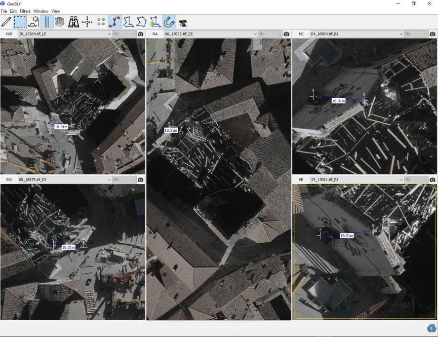
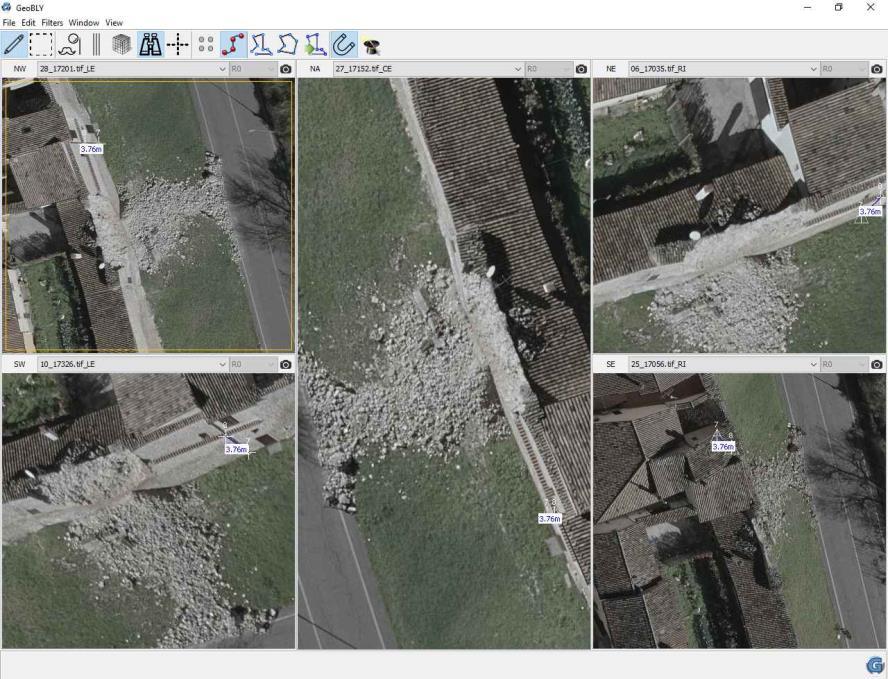
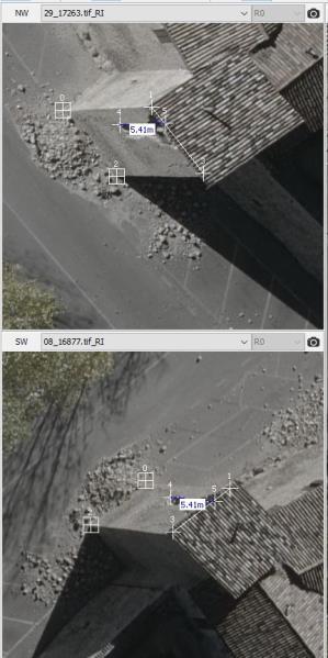

9 Damage assessment (Norcia) 17 Damage assessment (Norcia) 9


10 More applications Clearance height measurements Vertical signal mapping 19 More applications Inspection of power lines and constructions Facility management 20 10

 Visibility and modelling in very narrow streets Integration with other platforms, e.")
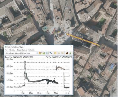
11 More applications VR integration IMAGE? Analysis view sheds, noise pollution, solar potentials 21 Image orientation: Challenges - geometry High quality in object space Physical model not necessarily complete DIM & 3D modelling Modelling of roof borders Combination with other approaches (i.e. mathematic morphology) Visibility and modelling in very narrow streets Integration with other platforms, e.g. mobile mapping systems in very narrow streets Computing optimization 22 11
12 Challenges radiometry & exchange Level of quality of nadir and oblique images Different levels, but quality of tools for oblique image processing area rapidly increasing GIS integration Slow implementation of oblique imagery in conventional GIS Solutions are still basic Stand-alone or simple add-on, lack of integration Expensive Tailored solutions for specific projects Full integration for measurement in oblique images Currently stand-alone viewer solutions, image formats partly not transparent Integration of mesh & mesh interactions Currently uncoordinated implementation of mesh integration 23 Conclusions Awareness of oblique imagery potential is growing in private and public entities Positive feedback by customers using oblique imagery Cost reduction of field work (mapping) Time reduction (mapping) Different building perspectives Occlusion reduction (min. 6 images for each object) Accessibility to whole area All-time image availability Requirements are more demanding but challenging Quality, interaction, sharing 24 12
USE OF VERTICAL AERIAL IMAGES FOR SEMI-OBLIQUE MAPPING
 USE OF VERTICAL AERIAL IMAGES FOR SEMI-OBLIQUE MAPPING D. Poli a, K. Moe a, K. Legat b, I. Toschi b, F. Lago b, F. Remondino b a Terra Messflug GmbH, Eichenweg 42, 6460 Imst, Austria (k.moe, d.poli)@terra-messflug.at
OBLIQUE AERIAL IMAGES: POTENTIALITIES, APPLICATIONS AND BEST PRACTICES FRANCESCO NEX
 OBLIQUE AERIAL IMAGES: POTENTIALITIES, APPLICATIONS AND BEST PRACTICES FRANCESCO NEX f.nex@utwente.nl The history of oblique imagery First recorded aerial photo in the US (1860) by J.W. Black and S. King
The use of different data sets in 3-D modelling
 The use of different data sets in 3-D modelling Ahmed M. HAMRUNI June, 2014 Presentation outlines Introduction Aims and objectives Test site and data Technology: Pictometry and UltraCamD Results and analysis
STATE-OF-THE-ART in DENSE IMAGE MATCHING
 STATE-OF-THE-ART in DENSE IMAGE MATCHING Fabio REMONDINO 3D Optical Metrology (3DOM) Bruno Kessler Foundation (FBK) Trento, Italy Email: remondino@fbk.eu http://3dom.fbk.eu Bruno Kessler Foundation (FBK)
Vexcel Imaging Ve V x e c x el e I l maging I G maging mbh www. wwwv. e v x e c x e c l e -limaging. - c imaging. om c
 Vexcel Imaging History 2016 MBO: becomes a privately owned company again 2006 Vexcel Imaging acquired by Microsoft Corp., Redmond/USA 2003 1992 1985 Merger of Vexcel Corp. & Vexcel Imaging 1 st Digital
POINT CLOUD ACQUISITION & STRUCTURING
 Point Cloud Processing 2018 March 13th, 2018 TU Delft, the Netherlands POINT CLOUD ACQUISITION & STRUCTURING Fabio REMONDINO 3D Optical Metrology (3DOM) Bruno Kessler Foundation (FBK) Trento, Italy Email:
Multi-ray photogrammetry: A rich dataset for the extraction of roof geometry for 3D reconstruction
 Multi-ray photogrammetry: A rich dataset for the extraction of roof geometry for 3D reconstruction Andrew McClune, Pauline Miller, Jon Mills Newcastle University David Holland Ordnance Survey Background
EVALUATION OF WORLDVIEW-1 STEREO SCENES AND RELATED 3D PRODUCTS
 EVALUATION OF WORLDVIEW-1 STEREO SCENES AND RELATED 3D PRODUCTS Daniela POLI, Kirsten WOLFF, Armin GRUEN Swiss Federal Institute of Technology Institute of Geodesy and Photogrammetry Wolfgang-Pauli-Strasse
THE ISPRS/EUROSDR BENCHMARK ON MULTI-PLATFORM PHOTOGRAMMETRY: RESULTS AND LESSON LEARNT FRANCESCO NEX AND MARKUS GERKE
 THE ISPRS/EUROSDR BENCHMARK ON MULTI-PLATFORM PHOTOGRAMMETRY: RESULTS AND LESSON LEARNT FRANCESCO NEX AND MARKUS GERKE Overview Summary of the results Statistics Data release What s next? ISPRS / EuroSDR
1. Introduction. A CASE STUDY Dense Image Matching Using Oblique Imagery Towards All-in- One Photogrammetry
 Submitted to GIM International FEATURE A CASE STUDY Dense Image Matching Using Oblique Imagery Towards All-in- One Photogrammetry Dieter Fritsch 1, Jens Kremer 2, Albrecht Grimm 2, Mathias Rothermel 1
STATUS OF AIRBORNE OBLIQUE IMAGING EUROSDR COMMISSION I PROJECT OBLIQUE IMAGERY. Markus Gerke May 15, 2014
 STATUS OF AIRBORNE OBLIQUE IMAGING EUROSDR COMMISSION I PROJECT OBLIQUE IMAGERY Markus Gerke May 15, 2014 THE FIRST AIRBORNE PHOTOS WERE OBLIQUE First recorded aerial photograph in the US (Boston), by
Enhancing photogrammetric 3d city models with procedural modeling techniques for urban planning support
 IOP Conference Series: Earth and Environmental Science OPEN ACCESS Enhancing photogrammetric 3d city models with procedural modeling techniques for urban planning support To cite this article: S Schubiger-Banz
OBLIQUE AERIAL IMAGERY FOR NMA SOME BEST PRACTICES
 OBLIQUE AERIAL IMAGERY FOR NMA SOME BEST PRACTICES F. Remondino 1, I. Toschi 1, M. Gerke 2, F. Nex 2, D. Holland 3, A. McGill 4, J. Talaya Lopez 5, A. Magarinos 5 1 3D Optical Metrology (3DOM) unit, Bruno
Presented at the FIG Congress 2018, May 6-11, 2018 in Istanbul, Turkey
 Presented at the FIG Congress 2018, May 6-11, 2018 in Istanbul, Turkey Evangelos MALTEZOS, Charalabos IOANNIDIS, Anastasios DOULAMIS and Nikolaos DOULAMIS Laboratory of Photogrammetry, School of Rural
Segmentation of 3D Photogrammetric Point Cloud for 3D Building Modeling
 Segmentation of 3D Photogrammetric Point Cloud for 3D Building Modeling EMRE ÖZDEMİR 1,2, Fabio Remondino 1 1 3D Optical Metrology unit Bruno Kessler Foundation (FBK) Trento, Italy https://3dom.fbk.eu
3D CITY MODELLING WITH CYBERCITY-MODELER
 1 3D CITY MODELLING WITH CYBERCITY-MODELER Kilian Ulm 1 and Daniela Poli 1 1. CyberCity AG, Zurich, Switzerland, (kilian.ulm, daniela.poli)@cybercity.tv ABSTRACT 3D city models using stereo aerial-/satellite
Automated Processing for 3D Mosaic Generation, a Change of Paradigm
 Automated Processing for 3D Mosaic Generation, a Change of Paradigm Frank BIGNONE, Japan Key Words: 3D Urban Model, Street Imagery, Oblique imagery, Mobile Mapping System, Parallel processing, Digital
Cultural Heritage. Geometric Recording of Cultural Monuments. Basic Principles of Geometric Recording. Specific requirements
 LOW COST DIGITAL PHOTOGRAMMETRIC TECHNIQUES FOR THE DOCUMENTATION OF CULTURAL HERITAGE Ch. Ioannidis, S. Soile, C. Potsiou Lab. of Photogrammetry School of Rural & Surveying Eng. National Technical University
PERFORMANCE OF LARGE-FORMAT DIGITAL CAMERAS
 PERFORMANCE OF LARGE-FORMAT DIGITAL CAMERAS K. Jacobsen Institute of Photogrammetry and GeoInformation, Leibniz University Hannover, Germany jacobsen@ipi.uni-hannover.de Inter-commission WG III/I KEY WORDS:
2017 PROGRAM OVERVIEW. Geospatial Intelligence for Better Outcomes
 2017 PROGRAM OVERVIEW Geospatial Intelligence for Better Outcomes NICB SOLUTION : GEOSPATIAL INTELLIGENCE CENTER Key Program Areas 1. CAT / Disaster Response 2. National Imagery Program 3. Digital Delivery
OBLIQUE AERIAL IMAGERY A REVIEW
 OBLIQUE AERIAL IMAGERY A REVIEW FABIO REMONDINO 3D Optical Metrology unit Bruno Kessler Foundation (FKB) Trento, Italy http://3dom.fbk.eu Email: remondino@fbk.eu MARKUS GERKE EOS dept. ITC / Univ. Twente,
3D recording of archaeological excavation
 5 th International Conference Remote Sensing in Archaeology The Age of Sensing 13-15 October 2014 - Duke University 3D recording of archaeological excavation Stefano Campana UNIVERSITY of CAMBRIDGE Faculty
Semi-Automatic Techniques for Generating BIM Façade Models of Historic Buildings
 Semi-Automatic Techniques for Generating BIM Façade Models of Historic Buildings C. Dore, M. Murphy School of Surveying & Construction Management Dublin Institute of Technology Bolton Street Campus, Dublin
BUNDLE BLOCK ADJUSTMENT WITH HIGH RESOLUTION ULTRACAMD IMAGES
 BUNDLE BLOCK ADJUSTMENT WITH HIGH RESOLUTION ULTRACAMD IMAGES I. Baz*, G. Buyuksalih*, K. Jacobsen** * BIMTAS, Tophanelioglu Cad. ISKI Hizmet Binasi No:62 K.3-4 34460 Altunizade-Istanbul, Turkey gb@bimtas.com.tr
Chapters 1-4: Summary
 Chapters 1-4: Summary So far, we have been investigating the image acquisition process. Chapter 1: General introduction Chapter 2: Radiation source and properties Chapter 3: Radiation interaction with
DIGITAL SURFACE MODELS OF CITY AREAS BY VERY HIGH RESOLUTION SPACE IMAGERY
 DIGITAL SURFACE MODELS OF CITY AREAS BY VERY HIGH RESOLUTION SPACE IMAGERY Jacobsen, K. University of Hannover, Institute of Photogrammetry and Geoinformation, Nienburger Str.1, D30167 Hannover phone +49
AUTOMATIC RECONSTRUCTION OF LARGE-SCALE VIRTUAL ENVIRONMENT FOR INTELLIGENT TRANSPORTATION SYSTEMS SIMULATION
 AUTOMATIC RECONSTRUCTION OF LARGE-SCALE VIRTUAL ENVIRONMENT FOR INTELLIGENT TRANSPORTATION SYSTEMS SIMULATION Khairil Azmi, Shintaro Ono, Masataka Kagesawa, Katsushi Ikeuchi Institute of Industrial Science,
AUTOMATIC EXTRACTION OF BUILDING FEATURES FROM TERRESTRIAL LASER SCANNING
 AUTOMATIC EXTRACTION OF BUILDING FEATURES FROM TERRESTRIAL LASER SCANNING Shi Pu and George Vosselman International Institute for Geo-information Science and Earth Observation (ITC) spu@itc.nl, vosselman@itc.nl
3D BUILDINGS MODELLING BASED ON A COMBINATION OF TECHNIQUES AND METHODOLOGIES
 3D BUILDINGS MODELLING BASED ON A COMBINATION OF TECHNIQUES AND METHODOLOGIES Georgeta Pop (Manea), Alexander Bucksch, Ben Gorte Delft Technical University, Department of Earth Observation and Space Systems,
Trimble Geospatial Division Integrated Solutions for Geomatics professions. Volker Zirn Regional Sales Representative
 Trimble Geospatial Division Integrated Solutions for Geomatics professions Volker Zirn Regional Sales Representative 1 Agenda Trimble GeoSpatial Division Airborne System Solutions Trimble Inpho Software
CURRENT DEVELOPMENTS IN AIRBORNE OBLIQUE IMAGING SYSTEMS AND AUTOMATED INTERPRETATION OF COMPLEX BUILDINGS. Markus Gerke
 CURRENT DEVELOPMENTS IN AIRBORNE OBLIQUE IMAGING SYSTEMS AND AUTOMATED INTERPRETATION OF COMPLEX BUILDINGS Markus Gerke THE FIRST AIRBORNE PHOTOS WERE OBLIQUE First recorded aerial photograph in the US
Trimble VISION Positions from Pictures
 Trimble VISION Positions from Pictures This session will cover What Is Trimble VISION? Trimble VISION Portfolio What Do you Need? How Does It Work & How Accurate Is It? Applications Resources Trimble VISION
Selective 4D modelling framework for spatialtemporal Land Information Management System
 Selective 4D modelling framework for spatialtemporal Land Information Management System A. Doulamis, S. Soile, N. Doulamis, C. Chrisouli, N. Grammalidis, K. Dimitropoulos C. Manesis, C. Potsiou, C. Ioannidis
Unwrapping of Urban Surface Models
 Unwrapping of Urban Surface Models Generation of virtual city models using laser altimetry and 2D GIS Abstract In this paper we present an approach for the geometric reconstruction of urban areas. It is
Outline of Presentation. Introduction to Overwatch Geospatial Software Feature Analyst and LIDAR Analyst Software
 Outline of Presentation Automated Feature Extraction from Terrestrial and Airborne LIDAR Presented By: Stuart Blundell Overwatch Geospatial - VLS Ops Co-Author: David W. Opitz Overwatch Geospatial - VLS
Reality Modeling Drone Capture Guide
 Reality Modeling Drone Capture Guide Discover the best practices for photo acquisition-leveraging drones to create 3D reality models with ContextCapture, Bentley s reality modeling software. Learn the
Surveying like never before
 CAD functionalities GCP Mapping and Aerial Image Processing Software for Land Surveying Specialists Surveying like never before www.3dsurvey.si Modri Planet d.o.o., Distributors: info@3dsurvey.si +386
EVALUATION OF WORLDVIEW-1 STEREO SCENES
 EVALUATION OF WORLDVIEW-1 STEREO SCENES Daniela Poli a, Kirsten Wolff b, Armin Gruen b a. European Commission, JRC, via Fermi 2749, Ispra (VA), Italy - daniela.poli@cec.europa.eu b. Swiss Federal Institute
UAV-based Mapping of Surface Imperviousness for Water Runoff Modelling
 UAV-based Mapping of Surface Imperviousness for Water Runoff Modelling Piotr Tokarczyk, Jörg Rieckermann, Frank Blumensaat, Joao Paulo Leitao and Konrad Schindler Institute for Geodesy and Photogrammetry
COMPARISON OF LASER SCANNING, PHOTOGRAMMETRY AND SfM-MVS PIPELINE APPLIED IN STRUCTURES AND ARTIFICIAL SURFACES
 COMPARISON OF LASER SCANNING, PHOTOGRAMMETRY AND SfM-MVS PIPELINE APPLIED IN STRUCTURES AND ARTIFICIAL SURFACES 2012 ISPRS Melbourne, Com III/4, S.Kiparissi Cyprus University of Technology 1 / 28 Structure
MONO-IMAGE INTERSECTION FOR ORTHOIMAGE REVISION
 MONO-IMAGE INTERSECTION FOR ORTHOIMAGE REVISION Mohamed Ibrahim Zahran Associate Professor of Surveying and Photogrammetry Faculty of Engineering at Shoubra, Benha University ABSTRACT This research addresses
THE INTERIOR AND EXTERIOR CALIBRATION FOR ULTRACAM D
 THE INTERIOR AND EXTERIOR CALIBRATION FOR ULTRACAM D K. S. Qtaishat, M. J. Smith, D. W. G. Park Civil and Environment Engineering Department, Mu ta, University, Mu ta, Karak, Jordan, 61710 khaldoun_q@hotamil.com
Mayden VP of Business Development Surdex Corporation
 Making Sense of Sensors Randy Mayden, Mayden VP of Business Development Surdex Corporation randym@surdex.com EARLYAERIAL PHOTOGRAPHY 2 FIRSTAERIAL CAMERA 3 AERIAL CAMERA SYSTEM DEVELOPMENT Aerial Camera
Image-based 3D Data Capture in Urban Scenarios
 Photogrammetric Week '15 Dieter Fritsch (Ed.) Wichmann/VDE Verlag, Belin & Offenbach, 2015 Haala, Rothermel 119 Image-based 3D Data Capture in Urban Scenarios Norbert Haala, Mathias Rothermel, Stuttgart
GENERATING BUILDING OUTLINES FROM TERRESTRIAL LASER SCANNING
 GENERATING BUILDING OUTLINES FROM TERRESTRIAL LASER SCANNING Shi Pu International Institute for Geo-information Science and Earth Observation (ITC), Hengelosestraat 99, P.O. Box 6, 7500 AA Enschede, The
High Definition Modeling of Calw, Badstrasse and its Google Earth Integration
 Master Thesis Yuanting LI High Definition Modeling of Calw, Badstrasse and its Google Earth Integration Duration of the Thesis: 6 months Completion: July, 2014 Supervisors: Prof.Dr.-Ing.Dieter Fritsch
ROAD SURFACE STRUCTURE MONITORING AND ANALYSIS USING HIGH PRECISION GPS MOBILE MEASUREMENT SYSTEMS (MMS)
") ROAD SURFACE STRUCTURE MONITORING AND ANALYSIS USING HIGH PRECISION GPS MOBILE MEASUREMENT SYSTEMS (MMS) Bonifacio R. Prieto PASCO Philippines Corporation, Pasig City, 1605, Philippines Email: bonifacio_prieto@pascoph.com
ROAD SURFACE STRUCTURE MONITORING AND ANALYSIS USING HIGH PRECISION GPS MOBILE MEASUREMENT SYSTEMS (MMS) Bonifacio R. Prieto PASCO Philippines Corporation, Pasig City, 1605, Philippines Email: bonifacio_prieto@pascoph.com
USE THE 3D LASER SCANNING FOR DOCUMENTATION THE RIGA CATHEDRAL IN LATVIA
 USE THE 3D LASER SCANNING FOR DOCUMENTATION THE RIGA CATHEDRAL IN LATVIA Maris Kalinka, Elina Rutkovska, Department of Geomatic, Riga Technical University, Azenes 16-109, Riga, Latvia, geomatika@geomatika.lv
3D MODELING OF CLOSE-RANGE OBJECTS: PHOTOGRAMMETRY OR LASER SCANNING?
 3D MODELING OF CLOSE-RANGE OBJECTS: PHOTOGRAMMETRY OR LASER SCANNING? F. Remondino 1 A. Guarnieri 2 A. Vettore 2 1 Institute of Geodesy and Photogrammetry ETH Hönggerberg - Zurich, Switzerland e-mail:
Automated Extraction of Buildings from Aerial LiDAR Point Cloud and Digital Imaging Datasets for 3D Cadastre - Preliminary Results
 Automated Extraction of Buildings from Aerial LiDAR Point Cloud and Digital Imaging Datasets for 3D Pankaj Kumar 1*, Alias Abdul Rahman 1 and Gurcan Buyuksalih 2 ¹Department of Geoinformation Universiti
STARTING WITH DRONES. Data Collection and Remote Sensing with UAVs, etc. Dr. Bill Hazelton LS
 STARTING WITH DRONES Data Collection and Remote Sensing with UAVs, etc. Dr. Bill Hazelton LS What this Talk is About UAV-based data acquisition: What you need to get involved Processes in getting spatial
Comparing Aerial Photogrammetry and 3D Laser Scanning Methods for Creating 3D Models of Complex Objects
 Comparing Aerial Photogrammetry and 3D Laser Scanning Methods for Creating 3D Models of Complex Objects A Bentley Systems White Paper Cyril Novel Senior Software Engineer, Bentley Systems Renaud Keriven
INTERPRETING BUILDING FAÇADES FROM VERTICAL AERIAL IMAGES USING THE THIRD DIMENSION
 INTERPRETING BUILDING FAÇADES FROM VERTICAL AERIAL IMAGES USING THE THIRD DIMENSION Meixner P. and Leberl F. Institute for Computer Graphics and Vision, Graz University of Technology, Inffeldgasse 16/II,
Programmable Graphics Processing Units for Urban Landscape Visualization
 Programmable Graphics Processing Units for Urban Landscape Visualization M. Kada, T. Balz, N. Haala, D. Fritsch Institute for Photogrammetry, Universität Stuttgart, Germany ABSTRACT: The availability of
Development of Geospatial Smart Cities and Management
 Presented at the FIG Congress 2018, May 6-11, 2018 in Istanbul, Turkey Development of Geospatial Smart Cities and Management (E. Yılmaz, F. Kartal, E. Uçar, K. Eren) FIG2018 - Istanbul, 8 th May 2018 1
Exterior Orientation Parameters
 Exterior Orientation Parameters PERS 12/2001 pp 1321-1332 Karsten Jacobsen, Institute for Photogrammetry and GeoInformation, University of Hannover, Germany The georeference of any photogrammetric product
Quality assessment of DIM on oblique images (preliminary results)
") FACULTY OF GEODESY AND CARTOGRAPHY W A R S A W U N I V E R S I T Y O F T E C H N O L O G Y Quality assessment of DIM on oblique images (preliminary results) Wojciech Ostrowski, Krzysztof Bakuła, Zdzisław
FACULTY OF GEODESY AND CARTOGRAPHY W A R S A W U N I V E R S I T Y O F T E C H N O L O G Y Quality assessment of DIM on oblique images (preliminary results) Wojciech Ostrowski, Krzysztof Bakuła, Zdzisław
The Leica Geosystems CityMapper Solution
 Photogrammetric Week '13 Dieter Fritsch (Ed.) Wichmann/VDE Verlag, Belin & Offenbach, 2013 Wagner et al. 89 The Leica Geosystems CityMapper Solution RUEDIGER WAGNER, Heerbrugg, Switzerland PETER LIECKFELDT,
Comeback of Digital Image Matching
 Photogrammetric Week '09 Dieter Fritsch (Ed.) Wichmann Verlag, Heidelberg, 2009 Haala 289 Comeback of Digital Image Matching NORBERT HAALA, Stuttgart ABSTRACT Despite the fact that tools for automatic
Towards Virtual Reality GIS
 'Photogrammetric Week 05' Dieter Fritsch, Ed. Wichmann Verlag, Heidelberg 2005. Haala 285 Towards Virtual Reality GIS NORBERT HAALA, Stuttgart ABSTRACT Due to the rapid developments in the field of computer
GRAPHICS TOOLS FOR THE GENERATION OF LARGE SCALE URBAN SCENES
 GRAPHICS TOOLS FOR THE GENERATION OF LARGE SCALE URBAN SCENES Norbert Haala, Martin Kada, Susanne Becker, Jan Böhm, Yahya Alshawabkeh University of Stuttgart, Institute for Photogrammetry, Germany Forename.Lastname@ifp.uni-stuttgart.de
RealWorld. HUAZHENG Panoramic Photorealistic 3D. Geospatial Data at Engineering Level
 3D RealWorld HUAZHENG Panoramic Photorealistic 3D Geospatial Data at Engineering Level District Drainage Facilities Management Simulate the extreme weather effect on buildings, road networks, and especially
DETERMINATION OF CORRESPONDING TRUNKS IN A PAIR OF TERRESTRIAL IMAGES AND AIRBORNE LASER SCANNER DATA
 The Photogrammetric Journal of Finland, 20 (1), 2006 Received 31.7.2006, Accepted 13.11.2006 DETERMINATION OF CORRESPONDING TRUNKS IN A PAIR OF TERRESTRIAL IMAGES AND AIRBORNE LASER SCANNER DATA Olli Jokinen,
CO-REGISTERING AND NORMALIZING STEREO-BASED ELEVATION DATA TO SUPPORT BUILDING DETECTION IN VHR IMAGES
 CO-REGISTERING AND NORMALIZING STEREO-BASED ELEVATION DATA TO SUPPORT BUILDING DETECTION IN VHR IMAGES Alaeldin Suliman, Yun Zhang, Raid Al-Tahir Department of Geodesy and Geomatics Engineering, University
Trimble GeoSpatial Products
 Expanding Solutions for Photogrammetric and Remote Sensing Professionals 55 th Photogrammetric Week in Stuttgart September 7 th 2015 Tobias Heuchel, Trimble Stuttgart, Germany Trimble GeoSpatial Products
Precise laser-based optical 3D measurement of welding seams under water
 Precise laser-based optical 3D measurement of welding seams under water ISPRS/CIPA Workshop Underwater 3D Recording & Modeling" Piano di Sorrento (Napoli), Italy 16. 17. April 2015 Tanja Ekkel (M.Sc.)
Using Databases for 3D Data Management From Point Cloud to City Model
 Using Databases for 3D Data Management From Point Cloud to City Model Hans Viehmann 1 1 ORACLE Corporation, Server Technologies Division, Hamburg, Germany, hans.viehmann@oracle.com Abstract With the cost
HIGH DENSITY AERIAL IMAGE MATCHING: STATE-OF-THE-ART AND FUTURE PROSPECTS
 HIGH DENSITY AERIAL IMAGE MATCHING: STATE-OF-THE-ART AND FUTURE PROSPECTS N. Haala a *, S. Cavegn a, b a Institute for Photogrammetry, University of Stuttgart, Germany - norbert.haala@ifp.uni-stuttgart.de
Assessing the Performance of Different Direct-Georeferencing with Large Format Digital Cameras
 Assessing the Performance of Different Direct-Georeferencing with Large Format Digital Cameras Civil and Environment Engineering Department, Mu ta University, Mu ta, Al-Karak, Jordan, 61710. E.mail: khaldoun_q@hotamil.com
GIS Data Collection. This chapter reviews the main methods of GIS data capture and transfer and introduces key practical management issues.
 9 GIS Data Collection OVERVIEW This chapter reviews the main methods of GIS data capture and transfer and introduces key practical management issues. It distinguishes between primary (direct measurement)
From Multi-sensor Data to 3D Reconstruction of Earth Surface: Innovative, Powerful Methods for Geoscience and Other Applications
 From Multi-sensor Data to 3D Reconstruction of Earth Surface: Innovative, Powerful Methods for Geoscience and Other Applications Bea Csatho, Toni Schenk*, Taehun Yoon* and Michael Sheridan, Department
FAST PRODUCTION OF VIRTUAL REALITY CITY MODELS
 FAST PRODUCTION OF VIRTUAL REALITY CITY MODELS Claus Brenner and Norbert Haala Institute for Photogrammetry (ifp) University of Stuttgart Geschwister-Scholl-Straße 24, 70174 Stuttgart, Germany Ph.: +49-711-121-4097,
2/19/2018. Who are we? Who am I? What is Scanning? How does scanning work? How does scanning work? Scanning for Today s Surveyors
 2/19/2018 Who are we? Scanning for Today s Surveyors Survey, GIS, and Construction dealer Founded in 1988 Employee Owned Headquartered in Bismarck, ND States covered: ND, SD, MN, MT, WY, CO, UT, ID, WA,
Oblique aerial photography viewer and monoplotting tool for building façade inspection and disaster assessment
 Oblique aerial photography viewer and monoplotting tool for building façade inspection and disaster assessment Arnadi Murtiyoso Department of Topography INSA Strasbourg, France arnadi.murtiyoso@insa-strasbourg.fr
Texturing Techniques in 3D City Modeling
 Texturing Techniques in 3D City Modeling 1 İdris Kahraman, 2 İsmail Rakıp Karaş, Faculty of Engineering, Department of Computer Engineering, Karabuk University, Turkey 1 idriskahraman@karabuk.edu.tr, 2
Comparing Aerial Photogrammetry and 3D Laser Scanning Methods for Creating 3D Models of Complex Objects
 www.bentley.com Comparing Aerial Photogrammetry and 3D Laser Scanning Methods for Creating 3D Models of Complex Objects A Bentley White Paper Cyril Novel Senior Software Engineer, Bentley Systems Renaud
Generating highly accurate 3D data using a sensefly exom drone
 Generating highly accurate 3D data using a sensefly exom drone C. Álvarez 1, A. Roze 2, A. Halter 3, L. Garcia 4 1 Geomatic Engineer, Lehmann Géomètre SA 2 Application Engineer, sensefly SA 3 Geomatic
Oblique Image Processing in SURE - First Experiments and Results
 EuroSDR / ISPRS Workshop, Southampton 2015 Oblique Image Processing in SURE - First Experiments and Results Mathias Rothermel Outline» General Workflow» 2.5D Meshing» Mesh Texturing» 3D Workflow» First
Support for external aerotriangulation results from professional systems (Inpho, Bingo).
.") PhotoMesh v7.2 PhotoMesh v7.2 fully automates the generation of high-resolution, textured, 3D mesh models from standard 2D photographs, offering a significant reduction in cost and time compared to traditional
PhotoMesh v7.2 PhotoMesh v7.2 fully automates the generation of high-resolution, textured, 3D mesh models from standard 2D photographs, offering a significant reduction in cost and time compared to traditional
REGISTRATION OF AIRBORNE LASER DATA TO SURFACES GENERATED BY PHOTOGRAMMETRIC MEANS. Y. Postolov, A. Krupnik, K. McIntosh
 REGISTRATION OF AIRBORNE LASER DATA TO SURFACES GENERATED BY PHOTOGRAMMETRIC MEANS Y. Postolov, A. Krupnik, K. McIntosh Department of Civil Engineering, Technion Israel Institute of Technology, Haifa,
Lecture 11. LiDAR, RADAR
 NRMT 2270, Photogrammetry/Remote Sensing Lecture 11 Calculating the Number of Photos and Flight Lines in a Photo Project LiDAR, RADAR Tomislav Sapic GIS Technologist Faculty of Natural Resources Management
Overview of the Trimble TX5 Laser Scanner
 Overview of the Trimble TX5 Laser Scanner Trimble TX5 Revolutionary and versatile scanning solution Compact / Lightweight Efficient Economical Ease of Use Small and Compact Smallest and most compact 3D
AUTOMATIC ROOF OUTLINES RECONSTRUCTION FROM PHOTOGRAMMETRIC DSM
 AUTOMATIC ROOF OUTLINES RECONSTRUCTION FROM PHOTOGRAMMETRIC DSM F. Nex, F. Remondino 3D Optical Metrology (3DOM) unit, Bruno Kessler Foundation (FBK), Trento, Italy @fbk.eu, http://3dom.fbk.eu
ISPRS Benchmark for Multi-Platform Photogrammetry
 ISPRS Benchmark for Multi-Platform Photogrammetry Francesco Nex (FBK) Markus Gerke (University of Twente/ITC) Fabio Remondino (FBK) Heinz-Jürgen Przybilla (HS Bochum) Manfred Bäumker (HS Bochum) Alexander
PhotoMesh v7.0. What s New in PhotoMesh v7.0
 PhotoMesh v7.0 PhotoMesh v7.0 fully automates the generation of high-resolution, textured, 3D mesh models from standard 2D photographs. Combining any number of photographs, in a wide range of formats and
AUTOMATIC GENERATION OF DIGITAL BUILDING MODELS FOR COMPLEX STRUCTURES FROM LIDAR DATA
 AUTOMATIC GENERATION OF DIGITAL BUILDING MODELS FOR COMPLEX STRUCTURES FROM LIDAR DATA Changjae Kim a, Ayman Habib a, *, Yu-Chuan Chang a a Geomatics Engineering, University of Calgary, Canada - habib@geomatics.ucalgary.ca,
Overview of the USGS Plan for Quality Assurance of Digital Aerial Imagery
 Overview of the USGS Plan for Quality Assurance of Digital Aerial Imagery Presented to MAPPS Conference March 14, 2006 U.S. Department of the Interior U.S. Geological Survey Outline Introduction Background
EnsoMOSAIC. Kopterit metsäninventointidatan keruualustoina
 EnsoMOSAIC Kopterit metsäninventointidatan keruualustoina 20.4.2017 Company introduction MosaicMill founded in 2009 EnsoMOSAIC technology since 1994 Main businesses EnsoMOSAIC forestry solutions EnsoMOSAIC
ADVANCING REALITY MODELING WITH CONTEXTCAPTURE
 ADVANCING REALITY MODELING WITH CONTEXTCAPTURE Knowing the existing conditions of a project is a key asset in any decision process. Governments need to better know their territories, through mapping operations,
Building a 3D reference model for canal tunnel surveying using SONAR and LASER scanning
 ISPRS / CIPA Workshop «UNDERWATER 3D RECORDING & MODELING» 16 17 April 2015 Piano di Sorrento (Napoli), Italy Building a 3D reference model for canal tunnel surveying using SONAR and LASER scanning E.
LiDAR for Urban Change Detection. Keith W. Cunningham, PhD Alaska Satellite Facility November 13, 2009
 LiDAR for Urban Change Detection Keith W. Cunningham, PhD Alaska Satellite Facility November 13, 2009 LiDAR LiDAR Light Detection and Ranging Building Footprints GIS outlines (planimetrics) GIS Geographic
BUILDING DETECTION AND STRUCTURE LINE EXTRACTION FROM AIRBORNE LIDAR DATA
 BUILDING DETECTION AND STRUCTURE LINE EXTRACTION FROM AIRBORNE LIDAR DATA C. K. Wang a,, P.H. Hsu a, * a Dept. of Geomatics, National Cheng Kung University, No.1, University Road, Tainan 701, Taiwan. China-
International Archives of Photogrammetry and Remote Sensing. Vol. XXXII, Part 5. Hakodate 1998
 International Archives of Photogrammetry and Remote Sensing. Vol. XXXII, Part 5. Hakodate 1998 RAPID ACQUISITION OF VIRTUAL REALITY CITY MODELS FROM MULTIPLE DATA SOURCES Claus Brenner and Norbert Haala
GEOMETRY AND INFORMATION CONTENTS OF LARGE SIZE DIGITAL FRAME CAMERAS
 GEOMETRY AND INFORMATION CONTENTS OF LARGE SIZE DIGITAL FRAME CAMERAS Karsten Jacobsen Institute of Photogrammetry and Geoinformation Leibniz University Hannover jacobsen@ipi.uni-hannover.de KEY WORDS:
N.J.P.L.S. An Introduction to LiDAR Concepts and Applications
 N.J.P.L.S. An Introduction to LiDAR Concepts and Applications Presentation Outline LIDAR Data Capture Advantages of Lidar Technology Basics Intensity and Multiple Returns Lidar Accuracy Airborne Laser
REPRESENTATION REQUIREMENTS OF AS-IS BUILDING INFORMATION MODELS GENERATED FROM LASER SCANNED POINT CLOUD DATA
 REPRESENTATION REQUIREMENTS OF AS-IS BUILDING INFORMATION MODELS GENERATED FROM LASER SCANNED POINT CLOUD DATA Engin Burak Anil 1 *, Burcu Akinci 1, and Daniel Huber 2 1 Department of Civil and Environmental
Course Outline (1) #6 Data Acquisition for Built Environment. Fumio YAMAZAKI
 #6 Data Acquisition for Built Environment. Fumio YAMAZAKI") AT09.98 Applied GIS and Remote Sensing for Disaster Mitigation #6 Data Acquisition for Built Environment 9 October, 2002 Fumio YAMAZAKI yamazaki@ait.ac.th http://www.star.ait.ac.th/~yamazaki/ Course Outline
AT09.98 Applied GIS and Remote Sensing for Disaster Mitigation #6 Data Acquisition for Built Environment 9 October, 2002 Fumio YAMAZAKI yamazaki@ait.ac.th http://www.star.ait.ac.th/~yamazaki/ Course Outline
ON THE USE OF MULTISPECTRAL AND STEREO DATA FROM AIRBORNE SCANNING SYSTEMS FOR DTM GENERATION AND LANDUSE CLASSIFICATION
 ON THE USE OF MULTISPECTRAL AND STEREO DATA FROM AIRBORNE SCANNING SYSTEMS FOR DTM GENERATION AND LANDUSE CLASSIFICATION Norbert Haala, Dirk Stallmann and Christian Stätter Institute for Photogrammetry
DMC GEOMETRIC PERFORMANCE ANALYSIS
 DMC GEOMETRIC PERFORMANCE ANALYSIS R.Alamús a, W.Kornus a, I.Riesinger b a Cartographic Institute of Catalonia (ICC), Barcelona, Spain - (ramon.alamus; wolfgang.kornus)@icc.cat b Chair for Photogrammetry
Terrestrial 3D laser scanning Practical aspects
 Terrestrial 3D laser scanning Practical aspects ISPRS WG VI/5&SC Summer School 2007 by Gregor Bilban 3D laser scanning Benefits Lower data collection costs Reduction or elimination of re-visits More accurate