Tree height measurements and tree growth estimation in a mire environment using digital surface models
|
|
|
- Abner Williams
- 6 years ago
- Views:
Transcription
1 Tree height measurements and tree growth estimation in a mire environment using digital surface models E. Baltsavias 1, A. Gruen 1, M. Küchler 2, P.Thee 2, L.T. Waser 2, L. Zhang 1 1 Institute of Geodesy & Photogrammetry, ETH Zurich, 2 Dept. of Landscape Inventories, Swiss Federal Research Institute WSL,
2 Contents Introduction, motivation, aims Test site, input data Methods Results, discussion Suggestions and further work Conclusions
3 Introduction, motivation, aims Project within Swiss Federal Mire Conservation Program Monitoring of mires and their vegetation over space and time Why? Federal Decree on Protection of Mires of National Importance (Federal Constitution Art.78 5) Who? WSL in partnership with the Swiss Federal Office for the Environment, Forest and Landscape How? 103 mire biotopes of national importance were selected with a stratified sampling method for monitoring Interdisciplinary cooperation between Geomatics and Landscape / Forest Inventories, also between sister institutions
4 Introduction, motivation, aims Within above program (but not only), determination of important parameters - vegetation (mainly tree) height - vegetation growth -> change over time (here mainly of height) - more broadly, determination of a 3D canopy model and of its changes, and possibly of other derived parameters For the above, currently only airborne sensors can be employed for costefficient, accurate-enough, large-sample studies. Main airborne sensors: cameras (digital or digitised film, ALS)
5 Introduction, motivation, aims Comparison of manual and automated image measurements and ALS for determination of above parameters, with special focus on automated image processing and DSM generation. - wide availability of images - determination of other parameters from images Aims: - automation (time and cost reduction), accuracy, completeness - test of good quality methods and software developed at ETHZ for DSM generation

6 Test Site LANDSAT TM-Mosaic of Switzerland , Source:


7 Test site 'Le Fanel' N / 7 03 E CIR orthoimage 2003


 with few storm losses and some new reforestations.")
8 Test site 'Le Fanel' Flat terrain (12 m height range) in an environmentally sensitive area along the lakeshore of Lake Neuchatel. Mire surrounded by forested area, with an extent of approx. 3 km 2, and mostly characterized by dense deciduous forest (80%) & coniferous (20%) with few storm losses and some new reforestations. Broad-leaved woodland with meadows and pastures are typical the site. forest for
9 Input data CIR aerial images (G, R, NIR), 1:5,000 scale, scanned with 14 microns (7 cm GSD), 75% forward overlap, acquired on Aug. 10th 1998 and Aug. 15th 2003 Processing of one strip, with 4 images Image orientation using 12 GCPs, measured with DGPS. Different orientation procedures for 1998 and 2003 images, remaining y-parallax in some of the 2003 images. Airborne Lidar data (Swisstopo), first and last pulse recorded, average point density 1 / 2 m 2, accuracy (1 sigma), 0.5 m in open spaces, 1.5 m in vegetation, acquired October 2002 (leaves on). ALS DSM edited. ALS data processed at WSL -> DTM and DSM with 1 m average point distance, interpolated to 1m regular grid by ETHZ Manual stereoscopic measurement of 181 tree tops in 1998 and 2003 images, different tree types, but not small ones among tall ones. Estimated height accuracy m.
10 Methods Tree height - measurement of highest visible tree point - measurement of ground. - In most cases impossible. - Measurement (manual) of ground points nearby, if terrain flat. - Reduction of DSM from matching to DTM using programs as for ALS, e.g. TerraScan, SCOP++ Lidar (but more difficult) - Here, use of ALS DTM for both 1998 and 2003 images. Ground can change height due to tree undergrowth. Here, assumption that there is no ground deformation. Tree growth Multitemporal comparison of tree heights. Difficulty in identifying the same point. Is it better to use a small neighbourhood of tree top?
11 Methods Automatic DSM generation from images a) using commecial package SocetSet (BAE Systems) - ATE method, use of cross-correlation - adaptation of matching strategy to mires (no elimination of small objects like bushes) m regular grid b) using ETHZ method, software Sat-PP - operational, quasi-full photogrammetric processing package - satellite and aerial sensors, frame and linear array geometry (ADS40 in preparation) m regular grid interpolated from point cloud of similar density - adaptive pixel patch size - no least-squares matching used - total processing time incl. grid interpolation ca. 5 h In all cases, DSM from matching was not manually edited


12 Automatic DSM generation with commercial systems Matching results, espec. with commercial systems, can vary a lot depending on the selection of the matching parameters (which have sometimes an unclear definition or at least effect). Below 3 automatically generated DSMs with DPW770, SocetSet. Left and right ATE, middle Adaptive ATE (effect of different matching strategies and matching parameters is clear).
13 Difficulties in image matching of forests Difficulties when matching one image dataset - occlusions - repetitive patterns - shadows - perspective differences - semi-transparent surfaces - rough surfaces, surface discontuities, mixed surfaces Above problems worse: - when no leaves - when using feature-based image matching (points, edges) Possible improvements - use of more than 2 images (large forward and side overlap) - use of geometric constraints - sophisticated matching methods, automatic blunder detection - match densely, use small GSD to reduce surface smoothing
14 Difficulties in image matching of forests Difficulties when comparing multitemporal image datasets - different image scales - different image quality - different growth state - different illumination and atmospheric conditions - different viewpoints - different image orientation Possible improvements - fly almost on the same date - good and similar illumination and atmospheric conditions - high sun elevation - leaves on - similar image acquisition parameters, using modern capabilities for precise navigation and pin-point photography
15 Manual measurement of reference data Difficulty in identifying the same point Possible planimetric differences between DSMs due to orientation differences (not checked in this case) Possible change of planimetric position of tree highest point Here, - reference points removed if planimetric difference between 1998 and 2003 tree top > 2 m - remaining points had in most cases planimetric difference less than 1 m - average planimetric position of 1998 and 2003 measurements used to interpolate height in DSMs from matching and ALS and compared to manual measurements. Average planimetry used to smooth image orientation differences and reduce uncertainty of point identification. ALS interpolated heights were corrected by 1 / 5 ( ) of average tree growth and compared to 2003 manual measurements

16 Results 1998 and 2003 CIR images. Significant differences in color, texture, shadows etc. Slightly poorer image quality in 1998 dataset.

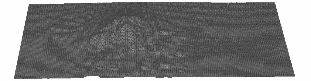
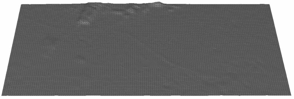
17 Results Grey level coded DSM using SocetSet from 1998 and 2003 CIR images.
18 Results 2003 CIR image and DSM from SocetSet.

19 Results DSM from 1998 and 2003 using ETHZ matching method.
20 Results 2003 CIR image and DSM using ETHZ matching.
21 Results 2003 CIR image and 2002 Lidar DSM.
22 Results Clockwise: 2003 CIR image, 2002 Lidar DSM, DSM using ETHZ method and SocetSet.
23 Results Tree height accuracy Statistics of DSM differences with reference data (interpolated tree height in DSM reference height). 181 points (manual tree heights 4-33 m), results in (m). Average with sign RMS Max. / # absolute differences > 1.5 & 5 m ETHZ DSM, 1998 images / 44 & 6 ETHZ DSM, 2003 images / 31 & 1 ALS DSM, 2002 data, (corrected for 2002 to 2003 difference) / 168 & 100
24 Results Tree Growth Statistics of tree height differences between 2003 and points, results in (m). Manual measurements ETHZ matching Growth differences (ETHZ matching manual) Average with sign RMS
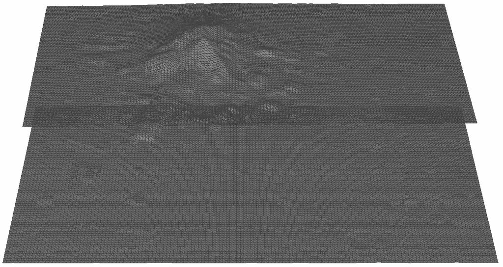
25 Results Comparison of DSMs Profile though two ETHZ and ALS DSMs. Left 2003 image.

26 Results Comparison of DSMs Profile though two ETHZ and ALS DSMs. Left 2003 image.
27 Results Discussion SocetSet results inferior to ETHZ method Both matching and ALS DSMs underestimate tree height (will always happen) Error statistics influenced by interpolating a regular grid and modelling errors ALS DSM - seems more crisp (less smooth) but looks quite irregular - quality of ALS DSM in forests questionable (not acquired for forestry applications) - statistics show poorer accuracy than matching DSM and more blunders - ALS DSM measures systematically below the canopy ETHZ DSM - very high point density - very few blunders, however, small errors remain results better than for 1998 due to image quality results close to manual measurement accuracy, espec. for tree growth - potential to derive 3D canopy model and growth using the whole tree volume.
28 Modelling errors - Quantitative comparison of DTM/DSM to reference data - Two comparisons: Height differences (2.5D): difference between the heights of reference data and the heights interpolated from generated DTM / DSM. Euclidean distance (3D): normal distance between the surfaces (Geomatic Studio v4.1 by Raindrop) - Limit of (2.5D) terrain height comparison: even if measurement correct, surface modeling error may cause large height differences (example: step egde below) Δh d
29 Further work and suggestions Need of more detailed analysis, e.g. - reasons for matching errors - relation of tree growth to tree type and tree height More tests with better image data (better quality, digital sensors, at least 60% sidelap and 6-wise image coverage of the scene, more similar imaging conditions and orientation). Use of ADS40 data of Swisstopo. Need of more extensive and better reference data, including various tree types and sizes and small possibly occluded trees Improve co-registration of DSMs for growth analysis DTM from manual measurements or good quality existing DTM. Use one DTM for growth analysis Derive tree height from local average around the highest point? Could also lead to blunder detection. Automate tree area detection and tree height measurement. Combination with information from digital sensors (RGB, NIR, texture). Alternatively, work semi-automatically.
30 Misregistration of DSMs Correct misregistration before performing multitemporal comparisons or with reference data

31 Co-registration of point clouds using LS3D matching
32 Co-registration of point clouds using LS3D matching
33 Further work and suggestions Dense automated measurements could lead in spite of errors to correct more global estimates - of tree height and other parameters, if number of trees high - of tree growth by not taking outliers into account, e.g. for a certain tree type and size, leave out largest and lowest growth values. For frequent observation of small areas, possibility to use other platforms, e.g. UAVs, and medium format digital sensors. All in all, promising results but need of further tests and increase of automation for tree height and growth estimation
SPOT-1 stereo images taken from different orbits with one month difference
 DSM Generation Almost all HR sensors are stereo capable. Some can produce even triplettes within the same strip (facilitating multi-image matching). Mostly SPOT (1-5) used for stereo and Ikonos (in spite
Section 5 Orthoimage generation
 Section 5 Orthoimage generation Emmanuel Baltsavias Orthoimage Generation Older sensor models methods: Kratky s Polynomial Mapping Functions (PMFs) Relief corrected affine transformation - Project GCPs
EVALUATION OF WORLDVIEW-1 STEREO SCENES AND RELATED 3D PRODUCTS
 EVALUATION OF WORLDVIEW-1 STEREO SCENES AND RELATED 3D PRODUCTS Daniela POLI, Kirsten WOLFF, Armin GRUEN Swiss Federal Institute of Technology Institute of Geodesy and Photogrammetry Wolfgang-Pauli-Strasse
Photogrammetric Performance of an Ultra Light Weight Swinglet UAV
 Photogrammetric Performance of an Ultra Light Weight Swinglet UAV J. Vallet, F. Panissod, C. Strecha, M. Tracol UAV-g 2011 - Unmanned Aerial Vehicle in Geomatics September 14-16, 2011ETH Zurich Summary
EVALUATION OF WORLDVIEW-1 STEREO SCENES
 EVALUATION OF WORLDVIEW-1 STEREO SCENES Daniela Poli a, Kirsten Wolff b, Armin Gruen b a. European Commission, JRC, via Fermi 2749, Ispra (VA), Italy - daniela.poli@cec.europa.eu b. Swiss Federal Institute
Presented at the FIG Congress 2018, May 6-11, 2018 in Istanbul, Turkey
 Presented at the FIG Congress 2018, May 6-11, 2018 in Istanbul, Turkey Evangelos MALTEZOS, Charalabos IOANNIDIS, Anastasios DOULAMIS and Nikolaos DOULAMIS Laboratory of Photogrammetry, School of Rural
ATOMI Automatic road centreline extraction
 ATOMI input and output data Ortho images DTM/DSM 2D inaccurate structured road vector data ATOMI Automatic road centreline extraction 3D accurate structured road vector data Classification of roads according
DSM generation with the Leica/Helava DPW 770 and VirtuoZo digital photogrammetric systems
 Research Collection Other Conference Item DSM generation with the Leica/Helava DPW 770 and VirtuoZo digital photogrammetric systems Author(s): Baltsavias, Emmanuel P. Publication Date: 1996 Permanent Link:
Multiray Photogrammetry and Dense Image. Photogrammetric Week Matching. Dense Image Matching - Application of SGM
 Norbert Haala Institut für Photogrammetrie Multiray Photogrammetry and Dense Image Photogrammetric Week 2011 Matching Dense Image Matching - Application of SGM p q d Base image Match image Parallax image
DENSE 3D POINT CLOUD GENERATION FROM UAV IMAGES FROM IMAGE MATCHING AND GLOBAL OPTIMAZATION
 DENSE 3D POINT CLOUD GENERATION FROM UAV IMAGES FROM IMAGE MATCHING AND GLOBAL OPTIMAZATION S. Rhee a, T. Kim b * a 3DLabs Co. Ltd., 100 Inharo, Namgu, Incheon, Korea ahmkun@3dlabs.co.kr b Dept. of Geoinformatic
Photogrammetry for forest inventory.
 Photogrammetry for forest inventory. Marc Pierrot Deseilligny. IGN/ENSG, France. Jonathan Lisein. Ulg Gembloux Agro-Bio Tech, Belgium. 1- Photogrammetry 2- Application to forestry 3- Tools and proposed
TRIMBLE BUSINESS CENTER PHOTOGRAMMETRY MODULE
 TRIMBLE BUSINESS CENTER PHOTOGRAMMETRY MODULE WHITE PAPER TRIMBLE GEOSPATIAL DIVISION WESTMINSTER, COLORADO, USA July 2013 ABSTRACT The newly released Trimble Business Center Photogrammetry Module is compatible
PROBLEMS AND LIMITATIONS OF SATELLITE IMAGE ORIENTATION FOR DETERMINATION OF HEIGHT MODELS
 PROBLEMS AND LIMITATIONS OF SATELLITE IMAGE ORIENTATION FOR DETERMINATION OF HEIGHT MODELS K. Jacobsen Institute of Photogrammetry and GeoInformation, Leibniz University Hannover, Germany jacobsen@ipi.uni-hannover.de
A COMPARISON OF LIDAR TERRAIN DATA WITH AUTOCORRELATED DSM EXTRACTED FROM DIGITALLY ACQUIRED HIGH OVERLAP PHOTOGRAPHY BACKGROUND
 A COMPARISON OF LIDAR TERRAIN DATA WITH AUTOCORRELATED DSM EXTRACTED FROM DIGITALLY ACQUIRED HIGH OVERLAP PHOTOGRAPHY Devin Kelley, Project Manager, Certified Photogrammetrist (ASPRS) Thomas Loecherbach,
DIGITAL SURFACE MODELS OF CITY AREAS BY VERY HIGH RESOLUTION SPACE IMAGERY
 DIGITAL SURFACE MODELS OF CITY AREAS BY VERY HIGH RESOLUTION SPACE IMAGERY Jacobsen, K. University of Hannover, Institute of Photogrammetry and Geoinformation, Nienburger Str.1, D30167 Hannover phone +49
Improving wide-area DEMs through data fusion - chances and limits
 Improving wide-area DEMs through data fusion - chances and limits Konrad Schindler Photogrammetry and Remote Sensing, ETH Zürich How to get a DEM for your job? for small projects (or rich people) contract
CO-REGISTERING AND NORMALIZING STEREO-BASED ELEVATION DATA TO SUPPORT BUILDING DETECTION IN VHR IMAGES
 CO-REGISTERING AND NORMALIZING STEREO-BASED ELEVATION DATA TO SUPPORT BUILDING DETECTION IN VHR IMAGES Alaeldin Suliman, Yun Zhang, Raid Al-Tahir Department of Geodesy and Geomatics Engineering, University
DSM GENERATION FROM EARLY ALOS/PRISM DATA USING SAT-PP
 DSM GENERATION FROM EARLY ALOS/PRISM DATA USING SAT-PP K. Wolff, A. Gruen Institute of Geodesy and Photogrammetry, ETH-Zurich, CH-8093 Zurich, Switzerland @geod.baug.ethz.ch KEY WORDS: PRISM
DIGITAL HEIGHT MODELS BY CARTOSAT-1
 DIGITAL HEIGHT MODELS BY CARTOSAT-1 K. Jacobsen Institute of Photogrammetry and Geoinformation Leibniz University Hannover, Germany jacobsen@ipi.uni-hannover.de KEY WORDS: high resolution space image,
ENY-C2005 Geoinformation in Environmental Modeling Lecture 4b: Laser scanning
 1 ENY-C2005 Geoinformation in Environmental Modeling Lecture 4b: Laser scanning Petri Rönnholm Aalto University 2 Learning objectives To recognize applications of laser scanning To understand principles
NATIONWIDE POINT CLOUDS AND 3D GEO- INFORMATION: CREATION AND MAINTENANCE GEORGE VOSSELMAN
 NATIONWIDE POINT CLOUDS AND 3D GEO- INFORMATION: CREATION AND MAINTENANCE GEORGE VOSSELMAN OVERVIEW National point clouds Airborne laser scanning in the Netherlands Quality control Developments in lidar
Files Used in this Tutorial
 Generate Point Clouds and DSM Tutorial This tutorial shows how to generate point clouds and a digital surface model (DSM) from IKONOS satellite stereo imagery. You will view the resulting point clouds
UP TO DATE DSM GENERATION USING HIGH RESOLUTION SATELLITE IMAGE DATA
 UP TO DATE DSM GENERATION USING HIGH RESOLUTION SATELLITE IMAGE DATA K. Wolff*, A. Gruen Institute of Geodesy and Photogrammetry, ETH Zurich Wolfgang-Pauli-Str. 15, CH-8093 Zurich, Switzerland (wolff,
The use of different data sets in 3-D modelling
 The use of different data sets in 3-D modelling Ahmed M. HAMRUNI June, 2014 Presentation outlines Introduction Aims and objectives Test site and data Technology: Pictometry and UltraCamD Results and analysis
DIGITAL SURFACE MODELS IN BUILD UP AREAS BASED ON VERY HIGH RESOLUTION SPACE IMAGES
 DIGITAL SURFACE MODELS IN BUILD UP AREAS BASED ON VERY HIGH RESOLUTION SPACE IMAGES Gurcan Buyuksalih*, Karsten Jacobsen** *BIMTAS, Tophanelioglu Cad. ISKI Hizmet Binasi No:62 K.3-4 34460 Altunizade-Istanbul,
Chapters 1 7: Overview
 Chapters 1 7: Overview Photogrammetric mapping: introduction, applications, and tools GNSS/INS-assisted photogrammetric and LiDAR mapping LiDAR mapping: principles, applications, mathematical model, and
EVOLUTION OF POINT CLOUD
 Figure 1: Left and right images of a stereo pair and the disparity map (right) showing the differences of each pixel in the right and left image. (source: https://stackoverflow.com/questions/17607312/difference-between-disparity-map-and-disparity-image-in-stereo-matching)
PHOTOGRAMMETRIC PERFORMANCE OF AN ULTRA LIGHT WEIGHT SWINGLET UAV
 International Archives of the Photogrammetry, Remote Sensing and Spatial Information Sciences, Vol.??, ISPRS ICWG I/V UAV-g (unmanned aerial vehicle in geomatics) conference, Zurich, Switzerland. 2011
New Requirements for the Relief in the Topographic Databases of the Institut Cartogràfic de Catalunya
 New Requirements for the Relief in the Topographic Databases of the Institut Cartogràfic de Catalunya Blanca Baella, Maria Pla Institut Cartogràfic de Catalunya, Barcelona, Spain Abstract Since 1983 the
PHOTOGRAMMETRIC PERFORMANCE OF AN ULTRA LIGHT WEIGHT SWINGLET UAV
 International Archives of the Photogrammetry, Remote Sensing and Spatial Information Sciences, Vol.??, ISPRS ICWG I/V UAV-g (unmanned aerial vehicle in geomatics) conference, Zurich, Switzerland. 2011
STATUS OF AIRBORNE OBLIQUE IMAGING EUROSDR COMMISSION I PROJECT OBLIQUE IMAGERY. Markus Gerke May 15, 2014
 STATUS OF AIRBORNE OBLIQUE IMAGING EUROSDR COMMISSION I PROJECT OBLIQUE IMAGERY Markus Gerke May 15, 2014 THE FIRST AIRBORNE PHOTOS WERE OBLIQUE First recorded aerial photograph in the US (Boston), by
2. POINT CLOUD DATA PROCESSING
 Point Cloud Generation from suas-mounted iphone Imagery: Performance Analysis A. D. Ladai, J. Miller Towill, Inc., 2300 Clayton Road, Suite 1200, Concord, CA 94520-2176, USA - (andras.ladai, jeffrey.miller)@towill.com
[Youn *, 5(11): November 2018] ISSN DOI /zenodo Impact Factor
![[Youn *, 5(11): November 2018] ISSN DOI /zenodo Impact Factor](/thumbs/91/105079225.jpg "[Youn *, 5(11): November 2018] ISSN DOI /zenodo Impact Factor") GLOBAL JOURNAL OF ENGINEERING SCIENCE AND RESEARCHES AUTOMATIC EXTRACTING DEM FROM DSM WITH CONSECUTIVE MORPHOLOGICAL FILTERING Junhee Youn *1 & Tae-Hoon Kim 2 *1,2 Korea Institute of Civil Engineering
GLOBAL JOURNAL OF ENGINEERING SCIENCE AND RESEARCHES AUTOMATIC EXTRACTING DEM FROM DSM WITH CONSECUTIVE MORPHOLOGICAL FILTERING Junhee Youn *1 & Tae-Hoon Kim 2 *1,2 Korea Institute of Civil Engineering
Automated Extraction of Buildings from Aerial LiDAR Point Cloud and Digital Imaging Datasets for 3D Cadastre - Preliminary Results
 Automated Extraction of Buildings from Aerial LiDAR Point Cloud and Digital Imaging Datasets for 3D Pankaj Kumar 1*, Alias Abdul Rahman 1 and Gurcan Buyuksalih 2 ¹Department of Geoinformation Universiti
SEMI-AUTOMATIC CITY MODEL EXTRACTION FROM TRI-STEREOSCOPIC VHR SATELLITE IMAGERY
 SEMI-AUTOMATIC CITY MODEL EXTRACTION FROM TRI-STEREOSCOPIC VHR SATELLITE IMAGERY F. Tack a,, R. Goossens a, G. Buyuksalih b a Dept. of Geography, Ghent University, Krijgslaan 281, 9000 Ghent, Belgium (f.tack,
1. Introduction. A CASE STUDY Dense Image Matching Using Oblique Imagery Towards All-in- One Photogrammetry
 Submitted to GIM International FEATURE A CASE STUDY Dense Image Matching Using Oblique Imagery Towards All-in- One Photogrammetry Dieter Fritsch 1, Jens Kremer 2, Albrecht Grimm 2, Mathias Rothermel 1
REGISTRATION OF AIRBORNE LASER DATA TO SURFACES GENERATED BY PHOTOGRAMMETRIC MEANS. Y. Postolov, A. Krupnik, K. McIntosh
 REGISTRATION OF AIRBORNE LASER DATA TO SURFACES GENERATED BY PHOTOGRAMMETRIC MEANS Y. Postolov, A. Krupnik, K. McIntosh Department of Civil Engineering, Technion Israel Institute of Technology, Haifa,
AUTOMATIC DSM GENERATION FROM LINEAR ARRAY IMAGERY DATA
 AUTOMATIC DSM GENERATION FROM LINEAR ARRAY IMAGERY DATA Zhang Li, Armin Gruen Institute of Geodesy and Photogrammetry, Swiss Federal Institute of Technology Zurich ETH Hoenggerberg; CH-8093 Zurich, Switzerland
UAV-based Mapping of Surface Imperviousness for Water Runoff Modelling
 UAV-based Mapping of Surface Imperviousness for Water Runoff Modelling Piotr Tokarczyk, Jörg Rieckermann, Frank Blumensaat, Joao Paulo Leitao and Konrad Schindler Institute for Geodesy and Photogrammetry
CLASSIFICATION OF NONPHOTOGRAPHIC REMOTE SENSORS
 CLASSIFICATION OF NONPHOTOGRAPHIC REMOTE SENSORS PASSIVE ACTIVE DIGITAL CAMERA THERMAL (e.g. TIMS) VIDEO CAMERA MULTI- SPECTRAL SCANNERS VISIBLE & NIR MICROWAVE HYPERSPECTRAL (e.g. AVIRIS) SLAR Real Aperture
Dense DSM Generation Using the GPU
 Photogrammetric Week '13 Dieter Fritsch (Ed.) Wichmann/VDE Verlag, Belin & Offenbach, 2013 Rotenberg et al. 285 Dense DSM Generation Using the GPU KIRILL ROTENBERG, LOUIS SIMARD, PHILIPPE SIMARD, Montreal
Least Squares 3D surface matching
 Least Squares 3D surface matching Devrim Akca Institute of Geodesy and Photogrammetry Swiss Federal Institute of Technology Zurich www.photogrammetry.ethz.ch 1 The Objective: Co-registration of overlapping
Using Hyperspectral Frame Images from Unmanned Airborne Vehicle for Detailed Measurement of Boreal Forest 3D Structure
 IOP Conference Series: Earth and Environmental Science PAPER OPEN ACCESS Using Hyperspectral Frame Images from Unmanned Airborne Vehicle for Detailed Measurement of Boreal Forest 3D Structure Recent citations
Geometric Accuracy Evaluation, DEM Generation and Validation for SPOT-5 Level 1B Stereo Scene
 Geometric Accuracy Evaluation, DEM Generation and Validation for SPOT-5 Level 1B Stereo Scene Buyuksalih, G.*, Oruc, M.*, Topan, H.*,.*, Jacobsen, K.** * Karaelmas University Zonguldak, Turkey **University
TrueOrtho with 3D Feature Extraction
 TrueOrtho with 3D Feature Extraction PCI Geomatics has entered into a partnership with IAVO to distribute its 3D Feature Extraction (3DFE) software. This software package compliments the TrueOrtho workflow
Automated Feature Extraction from Aerial Imagery for Forestry Projects
 Automated Feature Extraction from Aerial Imagery for Forestry Projects Esri UC 2015 UC706 Tuesday July 21 Bart Matthews - Photogrammetrist US Forest Service Southwestern Region Brad Weigle Sr. Program
Light Detection and Ranging (LiDAR)
") Light Detection and Ranging (LiDAR) http://code.google.com/creative/radiohead/ Types of aerial sensors passive active 1 Active sensors for mapping terrain Radar transmits microwaves in pulses determines
Light Detection and Ranging (LiDAR) http://code.google.com/creative/radiohead/ Types of aerial sensors passive active 1 Active sensors for mapping terrain Radar transmits microwaves in pulses determines
Evaluation of high resolution digital surface models for single tree extraction approaches in mixed forests
 Evaluation of high resolution digital surface models for single tree extraction approaches in mixed forests MOHSEN MIRI 1, STEVEN BAYER 2 & TILMAN BUCHER 3 Abstract: High resolution digital elevation models
SimActive and PhaseOne Workflow case study. By François Riendeau and Dr. Yuri Raizman Revision 1.0
 SimActive and PhaseOne Workflow case study By François Riendeau and Dr. Yuri Raizman Revision 1.0 Contents 1. Introduction... 2 1.1. Simactive... 2 1.2. PhaseOne Industrial... 2 2. Testing Procedure...
Calibration of IRS-1C PAN-camera
 Calibration of IRS-1C PAN-camera Karsten Jacobsen Institute for Photogrammetry and Engineering Surveys University of Hannover Germany Tel 0049 511 762 2485 Fax -2483 Email karsten@ipi.uni-hannover.de 1.
Mountain mapping and DSM generation using high resolution satellite image data
 Mountain mapping and DSM generation using high resolution satellite image data Mountain Mapping and Visualization Lenk, Switzerland, February 2008 K. Wolff, A. Grün Institut für Geodesie und Photogrammetrie
Quality Metrics of Semi Automatic DTM from Large Format Digital Camera
 Quality Metrics of Semi Automatic DTM from Large Format Digital Camera J. Narendran, P.Srinivas, M.Udayalakshmi, S.Muralikrishnan National Remote Sensing Centre, Indian Space Research Organization, Balanagar,
Terrestrial Laser Scanning: Applications in Civil Engineering Pauline Miller
 Terrestrial Laser Scanning: Applications in Civil Engineering Pauline Miller School of Civil Engineering & Geosciences Newcastle University Overview Laser scanning overview Research applications geometric
UAS based laser scanning for forest inventory and precision farming
 UAS based laser scanning for forest inventory and precision farming M. Pfennigbauer, U. Riegl, P. Rieger, P. Amon RIEGL Laser Measurement Systems GmbH, 3580 Horn, Austria Email: mpfennigbauer@riegl.com,
PHOTOGRAMMETRIC SOLUTIONS OF NON-STANDARD PHOTOGRAMMETRIC BLOCKS INTRODUCTION
 PHOTOGRAMMETRIC SOLUTIONS OF NON-STANDARD PHOTOGRAMMETRIC BLOCKS Dor Yalon Co-Founder & CTO Icaros, Inc. ABSTRACT The use of small and medium format sensors for traditional photogrammetry presents a number
N.J.P.L.S. An Introduction to LiDAR Concepts and Applications
 N.J.P.L.S. An Introduction to LiDAR Concepts and Applications Presentation Outline LIDAR Data Capture Advantages of Lidar Technology Basics Intensity and Multiple Returns Lidar Accuracy Airborne Laser
GENERATION OF DIGITAL SURFACE MODEL FROM HIGH RESOLUTION SATELLITE IMAGERY
 GENERATION OF DIGITAL SURFACE MODEL FROM HIGH RESOLUTION SATELLITE IMAGERY Chunsun Zhang a, *, Clive Fraser b a Geographic Information Science Center of Excellence (GIScCE), South Dakota State University,
GENERATION OF DIGITAL SURFACE MODEL FROM HIGH RESOLUTION SATELLITE IMAGERY INTRODUCTION
 GENERATION OF DIGITAL SURFACE MODEL FROM HIGH RESOLUTION SATELLITE IMAGERY Chunsun Zhang, Associate Professor Geographic Information Science Center of Excellence (GIScCE) South Dakota State University
Comeback of Digital Image Matching
 Photogrammetric Week '09 Dieter Fritsch (Ed.) Wichmann Verlag, Heidelberg, 2009 Haala 289 Comeback of Digital Image Matching NORBERT HAALA, Stuttgart ABSTRACT Despite the fact that tools for automatic
An Introduction to Lidar & Forestry May 2013
 An Introduction to Lidar & Forestry May 2013 Introduction to Lidar & Forestry Lidar technology Derivatives from point clouds Applied to forestry Publish & Share Futures Lidar Light Detection And Ranging
LiDAR Applications. Examples of LiDAR applications. forestry hydrology geology urban applications
 LiDAR Applications Examples of LiDAR applications forestry hydrology geology urban applications 1 Forestry applications canopy heights individual tree and crown mapping estimated DBH and leaf area index
POSITIONING A PIXEL IN A COORDINATE SYSTEM
 GEOREFERENCING AND GEOCODING EARTH OBSERVATION IMAGES GABRIEL PARODI STUDY MATERIAL: PRINCIPLES OF REMOTE SENSING AN INTRODUCTORY TEXTBOOK CHAPTER 6 POSITIONING A PIXEL IN A COORDINATE SYSTEM The essential
UAS Campus Survey Project
 ARTICLE STUDENTS CAPTURING SPATIAL INFORMATION NEEDS UAS Campus Survey Project Texas A&M University- Corpus Christi, home to the largest geomatics undergraduate programme in Texas, USA, is currently undergoing
LIDAR MAPPING FACT SHEET
 1. LIDAR THEORY What is lidar? Lidar is an acronym for light detection and ranging. In the mapping industry, this term is used to describe an airborne laser profiling system that produces location and
Geometry of Aerial photogrammetry. Panu Srestasathiern, PhD. Researcher Geo-Informatics and Space Technology Development Agency (Public Organization)
") Geometry of Aerial photogrammetry Panu Srestasathiern, PhD. Researcher Geo-Informatics and Space Technology Development Agency (Public Organization) Image formation - Recap The geometry of imaging system
Geometry of Aerial photogrammetry Panu Srestasathiern, PhD. Researcher Geo-Informatics and Space Technology Development Agency (Public Organization) Image formation - Recap The geometry of imaging system
VALIDATION OF A NEW 30 METER GROUND SAMPLED GLOBAL DEM USING ICESAT LIDARA ELEVATION REFERENCE DATA
 VALIDATION OF A NEW 30 METER GROUND SAMPLED GLOBAL DEM USING ICESAT LIDARA ELEVATION REFERENCE DATA M. Lorraine Tighe Director, Geospatial Solutions Intermap Session: Photogrammetry & Image Processing
POINT CLOUDS AND DERIVATIVES FOR NATIONWIDE GEOSPATIAL INFORMATION GEORGE VOSSELMAN
 POINT CLOUDS AND DERIVATIVES FOR NATIONWIDE GEOSPATIAL INFORMATION GEORGE VOSSELMAN OVERVIEW Point cloud generation and quality control New lidar technologies Dense matching Updating nationwide point clouds
AUTOMATIC IMAGE ORIENTATION BY USING GIS DATA
 AUTOMATIC IMAGE ORIENTATION BY USING GIS DATA Jeffrey J. SHAN Geomatics Engineering, School of Civil Engineering Purdue University IN 47907-1284, West Lafayette, U.S.A. jshan@ecn.purdue.edu Working Group
Extracting Elevation from Air Photos
 Extracting Elevation from Air Photos TUTORIAL A digital elevation model (DEM) is a digital raster surface representing the elevations of a terrain for all spatial ground positions in the image. Traditionally
TRAINING MATERIAL HOW TO OPTIMIZE ACCURACY WITH CORRELATOR3D
 TRAINING MATERIAL WITH CORRELATOR3D Page2 Contents 1. UNDERSTANDING INPUT DATA REQUIREMENTS... 4 1.1 What is Aerial Triangulation?... 4 1.2 Recommended Flight Configuration... 4 1.3 Data Requirements for
MODELLING FOREST CANOPY USING AIRBORNE LIDAR DATA
 MODELLING FOREST CANOPY USING AIRBORNE LIDAR DATA Jihn-Fa JAN (Taiwan) Associate Professor, Department of Land Economics National Chengchi University 64, Sec. 2, Chih-Nan Road, Taipei 116, Taiwan Telephone:
3D MODELING OF CLOSE-RANGE OBJECTS: PHOTOGRAMMETRY OR LASER SCANNING?
 3D MODELING OF CLOSE-RANGE OBJECTS: PHOTOGRAMMETRY OR LASER SCANNING? F. Remondino 1 A. Guarnieri 2 A. Vettore 2 1 Institute of Geodesy and Photogrammetry ETH Hönggerberg - Zurich, Switzerland e-mail:
COMBINING HIGH RESOLUTION SATELLITE IMAGERY AND AIRBORNE LASER SCANNING DATA FOR GENERATING BARELAND DEM IN URBAN AREAS
 COMBINING HIGH RESOLUTION SATELLITE IMAGERY AND AIRBORNE LASER SCANNING DATA FOR GENERATING BARELAND IN URBAN AREAS Guo Tao *, Yoshifumi Yasuoka Institute of Industrial Science, University of Tokyo, 4-6-1
2-4 April 2019 Taets Art and Event Park, Amsterdam CLICK TO KNOW MORE
 Co-Host Host 2-4 April 2019 Taets Art and Event Park, Amsterdam CLICK TO KNOW MORE Presentation Outline review modern survey methodologies available to support railway requirements measuring everything
DATA FUSION FOR MULTI-SCALE COLOUR 3D SATELLITE IMAGE GENERATION AND GLOBAL 3D VISUALIZATION
 DATA FUSION FOR MULTI-SCALE COLOUR 3D SATELLITE IMAGE GENERATION AND GLOBAL 3D VISUALIZATION ABSTRACT: Yun Zhang, Pingping Xie, and Hui Li Department of Geodesy and Geomatics Engineering, University of
BUILDING DETECTION AND STRUCTURE LINE EXTRACTION FROM AIRBORNE LIDAR DATA
 BUILDING DETECTION AND STRUCTURE LINE EXTRACTION FROM AIRBORNE LIDAR DATA C. K. Wang a,, P.H. Hsu a, * a Dept. of Geomatics, National Cheng Kung University, No.1, University Road, Tainan 701, Taiwan. China-
National Science Foundation Engineering Research Center. Bingcai Zhang BAE Systems San Diego, CA
 Bingcai Zhang BAE Systems San Diego, CA 92127 Bingcai.zhang@BAESystems.com Introduction It is a trivial task for a five-year-old child to recognize and name an object such as a car, house or building.
Terrain Modeling and Mapping for Telecom Network Installation Using Scanning Technology. Maziana Muhamad
 Terrain Modeling and Mapping for Telecom Network Installation Using Scanning Technology Maziana Muhamad Summarising LiDAR (Airborne Laser Scanning) LiDAR is a reliable survey technique, capable of: acquiring
3D CITY MODELLING WITH CYBERCITY-MODELER
 1 3D CITY MODELLING WITH CYBERCITY-MODELER Kilian Ulm 1 and Daniela Poli 1 1. CyberCity AG, Zurich, Switzerland, (kilian.ulm, daniela.poli)@cybercity.tv ABSTRACT 3D city models using stereo aerial-/satellite
Efficient Processing of UAV Projects
 Efficient Processing of UAV Projects Dr. Philippe Simard President SimActive Inc. IMAGE About SimActive Leading developer of photogrammetry software since 2003 Thousands of users in 50+ countries: military
APPENDIX E2. Vernal Pool Watershed Mapping
 APPENDIX E2 Vernal Pool Watershed Mapping MEMORANDUM To: U.S. Fish and Wildlife Service From: Tyler Friesen, Dudek Subject: SSHCP Vernal Pool Watershed Analysis Using LIDAR Data Date: February 6, 2014
VEGETATION Geometrical Image Quality
 VEGETATION Geometrical Image Quality Sylvia SYLVANDER*, Patrice HENRY**, Christophe BASTIEN-THIRY** Frédérique MEUNIER**, Daniel FUSTER* * IGN/CNES **CNES CNES, 18 avenue Edouard Belin, 31044 Toulouse
MODELING OF THE PLAN DA MATTUN ARCHAEOLOGICAL SITE USING A COMBINATION OF DIFFERENT SENSORS
 MODELING OF THE PLAN DA MATTUN ARCHAEOLOGICAL SITE USING A COMBINATION OF DIFFERENT SENSORS D. Novák, P. Tokarczyk*, P.W. Theiler Institute of Geodesy and Photogrammetry, ETH Zürich, 8093 Zürich, Switzerland
PERFORMANCE OF LARGE-FORMAT DIGITAL CAMERAS
 PERFORMANCE OF LARGE-FORMAT DIGITAL CAMERAS K. Jacobsen Institute of Photogrammetry and GeoInformation, Leibniz University Hannover, Germany jacobsen@ipi.uni-hannover.de Inter-commission WG III/I KEY WORDS:
THE ISPRS/EUROSDR BENCHMARK ON MULTI-PLATFORM PHOTOGRAMMETRY: RESULTS AND LESSON LEARNT FRANCESCO NEX AND MARKUS GERKE
 THE ISPRS/EUROSDR BENCHMARK ON MULTI-PLATFORM PHOTOGRAMMETRY: RESULTS AND LESSON LEARNT FRANCESCO NEX AND MARKUS GERKE Overview Summary of the results Statistics Data release What s next? ISPRS / EuroSDR
Improvement of the Edge-based Morphological (EM) method for lidar data filtering
 method for lidar data filtering") International Journal of Remote Sensing Vol. 30, No. 4, 20 February 2009, 1069 1074 Letter Improvement of the Edge-based Morphological (EM) method for lidar data filtering QI CHEN* Department of Geography,
International Journal of Remote Sensing Vol. 30, No. 4, 20 February 2009, 1069 1074 Letter Improvement of the Edge-based Morphological (EM) method for lidar data filtering QI CHEN* Department of Geography,
Image-based 3D Data Capture in Urban Scenarios
 Photogrammetric Week '15 Dieter Fritsch (Ed.) Wichmann/VDE Verlag, Belin & Offenbach, 2015 Haala, Rothermel 119 Image-based 3D Data Capture in Urban Scenarios Norbert Haala, Mathias Rothermel, Stuttgart
DETECTION OF CHANGES IN ISTANBUL AREA WITH MEDIUM AND HIGH RESOLUTION SPACE IMAGES
 DETECTION OF CHANGES IN ISTANBUL AREA WITH MEDIUM AND HIGH RESOLUTION SPACE IMAGES S. Bayburt*, G.Büyüksalih*, I. Baz*, K. Jacobsen**, T. Kersten *** * BIMTAS, Tophanelioglu Cad. ISKI Hizmet Binasi No:62
BUNDLE BLOCK ADJUSTMENT WITH HIGH RESOLUTION ULTRACAMD IMAGES
 BUNDLE BLOCK ADJUSTMENT WITH HIGH RESOLUTION ULTRACAMD IMAGES I. Baz*, G. Buyuksalih*, K. Jacobsen** * BIMTAS, Tophanelioglu Cad. ISKI Hizmet Binasi No:62 K.3-4 34460 Altunizade-Istanbul, Turkey gb@bimtas.com.tr
TLS DEFORMATION MEASUREMENT USING LS3D SURFACE AND CURVE MATCHING
 TLS DEFORMATION MEASUREMENT USING LS3D SURFACE AND CURVE MATCHING O. Monserrat, M. Crosetto, B. Pucci Institute of Geomatics, Castelldefels, Barcelona, Spain, (oriol.monserrat, michele.crosetto, barbara.pucci)@ideg.es
A METHOD TO PREDICT ACCURACY OF LEAST SQUARES SURFACE MATCHING FOR AIRBORNE LASER SCANNING DATA SETS
 A METHOD TO PREDICT ACCURACY OF LEAST SQUARES SURFACE MATCHING FOR AIRBORNE LASER SCANNING DATA SETS Robert Pâquet School of Engineering, University of Newcastle Callaghan, NSW 238, Australia (rpaquet@mail.newcastle.edu.au)
DEVELOPMENT OF ORIENTATION AND DEM/ORTHOIMAGE GENERATION PROGRAM FOR ALOS PRISM
 DEVELOPMENT OF ORIENTATION AND DEM/ORTHOIMAGE GENERATION PROGRAM FOR ALOS PRISM Izumi KAMIYA Geographical Survey Institute 1, Kitasato, Tsukuba 305-0811 Japan Tel: (81)-29-864-5944 Fax: (81)-29-864-2655
Generating highly accurate 3D data using a sensefly exom drone
 Generating highly accurate 3D data using a sensefly exom drone C. Álvarez 1, A. Roze 2, A. Halter 3, L. Garcia 4 1 Geomatic Engineer, Lehmann Géomètre SA 2 Application Engineer, sensefly SA 3 Geomatic
FILTERING OF DIGITAL ELEVATION MODELS
 FILTERING OF DIGITAL ELEVATION MODELS Dr. Ing. Karsten Jacobsen Institute for Photogrammetry and Engineering Survey University of Hannover, Germany e-mail: jacobsen@ipi.uni-hannover.de Dr. Ing. Ricardo
Application and Precision Analysis of Tree height Measurement with LiDAR
 Application and Precision Analysis of Tree height Measurement with LiDAR Hejun Li a, BoGang Yang a,b, Xiaokun Zhu a a Beijing Institute of Surveying and Mapping, 15 Yangfangdian Road, Haidian District,
MASI: Modules for Aerial and Satellite Imagery
 MASI: Modules for Aerial and Satellite Imagery Product Descriptions and Typical Applied Cases Dr. Jinghui Yang jhyang@vip.163.com Sept. 18, 2017 File Version: v1.0 VisionOnSky Co., Ltd. Contents 1 Descriptions
Automatic DEM Extraction
 Technical Specifications Automatic DEM Extraction The Automatic DEM Extraction module allows you to create Digital Elevation Models (DEMs) from stereo airphotos, stereo images and RADAR data. Image correlation
A NEW APPROACH FOR GENERATING A MEASURABLE SEAMLESS STEREO MODEL BASED ON MOSAIC ORTHOIMAGE AND STEREOMATE
 A NEW APPROACH FOR GENERATING A MEASURABLE SEAMLESS STEREO MODEL BASED ON MOSAIC ORTHOIMAGE AND STEREOMATE Mi Wang State Key Laboratory of Information Engineering in Surveying Mapping and Remote Sensing
DEM GENERATION WITH SHORT BASE LENGTH PLEIADES TRIPLET
 DEM GENERATION WITH SHORT BASE LENGTH PLEIADES TRIPLET K. Jacobsen a, H. Topan b a Leibniz University Hannover, Institute of Photogrammetry and Geoinformation, Germany; b Bülent Ecevit University, Zonguldak,
Photogrammetry and 3D city modelling
 Digital Architecture and Construction 209 Photogrammetry and 3D city modelling Y. Kobayashi School of Architecture and Landscape Architecture, Arizona State University, USA Abstract 3D city modelling and