Iwane Laboratories, Ltd.
|
|
|
- James Harold Greene
- 6 years ago
- Views:
Transcription


1 2011 Iwane Laboratories, Ltd.

2 Introduction of a highly accurate threedimensional map making system termed as Map on 3D based on the IMS3 Dual Cam Map on 3D can detect three-dimensional shape of the road white lines marking directly with high accuracy the results of which are detailed in this document.

 Auto CV")

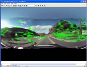


3 Shooting Using IMS3(Dual Cam) Auto CV Process/Coordinate Integration Movie Making Map on 3D Auto White Lines Recognition/ 3D Analysis/Map Making Manual Final Process /Quality Check
4 To create highly accurate three-dimensional map and the highly accurate road map using ortho-rectification. The road section processing is automated whereas other areas can be extracted using 3DPCCI (3D model can be created from CV image) in a semi automated process. * Please see the Error Evaluation document on website about the error and accuracy. The complete spherical (360degree) image without any dead angle can be used by the GIS industry besides the Survey vertical.


5 Side Elevation Front Elevation Upper Side Camera Making 3 dimension by parallax angle created by the two camera system Down Side Camera Around 1m zone Strip of Image data Upper Side Camera Down Side Camera Three-dimensional by the corresponding Upper and Down Side
 - We can align the shape and re-convert this original data to one complete white line in the final stage of data processing.")

6 - This output is during data processing phase and consists of group of 3D shaped rectangles in the form of vector lines each 1 meter in length. (Blue lines are camera tracks) - We can align the shape and re-convert this original data to one complete white line in the final stage of data processing. - We generate these 3D shape rectangles through CV figure only without the use of GPS/IMU data as this is for our accuracy check. Integration of GPS/IMU data, aligning white lines, and making continuous white line are performed while making Ortho map during the final phase of data processing. (Available without GPS till here) - Road maps can be produced as a final product by projecting these 3D vector data on to Ortho plane.
 is around 1-2 cm (our assumption ) on the white line with a width of 15cm.")

7 - Based on tracking of street surface by surface facing camera, highly accurate CV figure can be achieved. - The combination of frames is sufficient enough to estimate that 3D error (relative accuracy) is around 1-2 cm (our assumption ) on the white line with a width of 15cm. - All the above steps are fully automated process. - Possible to process CV image of streets having 4 lanes with high accuracy. Measuring the distance between the white line accuracy ± 2 ~ 3 cm - If the accuracy is not sufficient in case where there are more lanes, we can use 3D coordinate integration which we have demonstrated before. For example, we acquire two-way street image data(both directions) and combine them based on this CV integration technique.

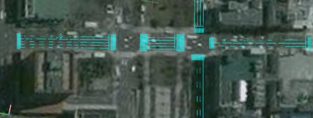
8 We can resolve the gap between CV figure of image A and B at intersections by integration of coordinates (Inco). We use the common objects in both images and adjust CV figure using Inco. This is an unique advantage of CV technology which is not available in other options. Capabilities of Inco A B Image A & B captured at different time intervals can be integrated and used in the same 3D space and coordinate. Several images can be integrated and used in the same 3D space and coordinates. Each object certainly will have the same coordinates on each image. Capable of handling a wide range by this integration of coordinates. Relative accuracy can be improved further. Automated updating is available between several images captured by different cameras at different time.


9 *This data is acquired only by CV processing without GPS.
10 - In Map on 3D, our current focus is only on white lines located on both sides of the camera for recognition and converting them into 3D vector lines. However, we can also secure the same accuracy for other objects. - Going ahead, we will develop Automatic 3D Map which can recognize other feature objects on the streets such as curb, manhole, rain water mass, pavement side, ground boundary, signal, signboard, and building shape, etc.


.")


11 It can be used for editing polygon (adding, modification, deletion) freely because it is based on 3D CG modeling tool (3D PCCI). Fences and other facilities can be input manually. Data compatible format Output FBX You can use AUTOCAD to edit and finalize. Auto-detected white line (etc.) displayed in image as three-dimensional polygon. Manual editing is possible (Adding, modification, deletion).


12 Enables creation of three-dimensional objects on the road surface Enables creation of objects and the feature to create / edit an object in threedimension for the polygons on the road surface and the building surface. Layer Control Road infrastructure and Facilities Construction can be managed separately for each object layer. Layers can be added which enables comprehensive asset management.


13 The principle is similar to white line detection, technique developed to detect the curb curb-only process" using the image features of the curb. Curb detection demarcates the boundaries of the road and the sidewalk.
14 - Using several ways like IMS3 Dual Cam, Street surface tracking, compound epipolar plane, CV accuracy has improved considerably and reached to the unit of millimeter in a relative figure. In addition to this, we have also achieved 1 or 2 centimeter (relative accuracy) in 3D measurements based on distance from the camera position.(relative scale of objects within 10 meter from the camera). - In the near future, we can produce 2D maps within a few hours of capturing street imagery by IMS3. - Our final target is to achieve a 95 % fully automated process and we aim to achieve a process with less than 5% manual intervention. Iwane s 3D PCCI tool is partially automated. - This technology can be also applied directly for both ACCI (Fully Automated Technology for Creation of 3DCG) and Machine Map. The accuracy of IMS2 is less than IMS3 (Dual Cam) and IMS2 is the best suitable for GIS, ALV-2 for Arc GIS Digital Street Scanner-2 (Ortho making Software), 3D PCCI-2 and iicosmo. On the other hand, IMS3 (Dual Cam) can produce highly accurate maps and can also be used to create ALV-2for ArcGIS, Digital Street Scanner-2 ( Ortho making Software ) and iicosmo.
A New Direction in GIS Data Collection or Why Are You Still in the Field?
 GeoAutomation The Mobile Mapping System Survey-Enabled Imagery A New Direction in GIS Data Collection or Why Are You Still in the Field? Presentation to: URISA BC GIS Technology Showcase January 19, 2011
Iwane Mobile Mapping System
 Iwane Mobile Mapping System Geo-Imaging Mobile Mapping Solution Iwane Mobile Mapping System (IMMS) is high-efficient, easyto-use, end-to-end solution that provides tremendous flexibility in collecting,
User s guide. November LSE S.r.l. All rights reserved
 User s guide November 2015 2015 LSE S.r.l. All rights reserved WARNING In writing this manual every care has been taken to offer the most updated, correct and clear information possible; however unwanted
ROAD SURFACE STRUCTURE MONITORING AND ANALYSIS USING HIGH PRECISION GPS MOBILE MEASUREMENT SYSTEMS (MMS)
") ROAD SURFACE STRUCTURE MONITORING AND ANALYSIS USING HIGH PRECISION GPS MOBILE MEASUREMENT SYSTEMS (MMS) Bonifacio R. Prieto PASCO Philippines Corporation, Pasig City, 1605, Philippines Email: bonifacio_prieto@pascoph.com
ROAD SURFACE STRUCTURE MONITORING AND ANALYSIS USING HIGH PRECISION GPS MOBILE MEASUREMENT SYSTEMS (MMS) Bonifacio R. Prieto PASCO Philippines Corporation, Pasig City, 1605, Philippines Email: bonifacio_prieto@pascoph.com
Mobile Mapping Solutions for Ohio s Integrated Transportation Network. Brian Foster, CP
 Mobile Mapping Solutions for Ohio s Integrated Transportation Network Brian Foster, CP About Woolpert Established in 1911 Over 600 Professionals 25 Offices $12,000,000 invested in new technology in last
2010 LiDAR Project. GIS User Group Meeting June 30, 2010
 2010 LiDAR Project GIS User Group Meeting June 30, 2010 LiDAR = Light Detection and Ranging Technology that utilizes lasers to determine the distance to an object or surface Measures the time delay between
Using ArcGIS Server Data to Assist in Planimetric Update Process. Jim Stout - IMAGIS Rick Hammond Woolpert
 Using ArcGIS Server Data to Assist in Planimetric Update Process Jim Stout - IMAGIS Rick Hammond Woolpert Using ArcGIS Server Data to Assist in Planimetric Update Process Jim Stout - IMAGIS Rick Hammond
High resolution survey and orthophoto project of the Dosso-Gaya region in the Republic of Niger. by Tim Leary, Woolpert Inc.
 High resolution survey and orthophoto project of the Dosso-Gaya region in the Republic of Niger by Tim Leary, Woolpert Inc. Geospatial Solutions Photogrammetry & Remote Sensing LiDAR Professional Surveying
Airborne Laser Survey Systems: Technology and Applications
 Abstract Airborne Laser Survey Systems: Technology and Applications Guangping HE Lambda Tech International, Inc. 2323B Blue Mound RD., Waukesha, WI-53186, USA Email: he@lambdatech.com As mapping products
Unwrapping of Urban Surface Models
 Unwrapping of Urban Surface Models Generation of virtual city models using laser altimetry and 2D GIS Abstract In this paper we present an approach for the geometric reconstruction of urban areas. It is
ROAD-SCANNER COMPACT APPLICATION FIELDS MAIN FEATURES
 ROAD-SCANNER COMPACT Mobile Mapping System by GEXCEL & SITECO collaboration A smaller mobile system for asset management and cartography suited for ZOLLER & FRÖHLICH PROFILER 9012 laser scanner. 2 + 3
Option Driver Assistance. Product Information
 Product Information Table of Contents 1 Overview... 3 1.1 Introduction... 3 1.2 Features and Advantages... 3 1.3 Application Areas... 4 1.4 Further Information... 5 2 Functions... 5 3 Creating the Configuration
Mobile Mapping with the Road-Scanner in France Hi-grade 1:200 scale mapping
 FARO USER CONFERENCE APRIL 27-28 2014 Mobile Mapping with the Road-Scanner in France Hi-grade 1:200 scale mapping 03/04/2014 ing. Augusto Burchi burchi@sitecoinf.it Siteco's profile Founded in 2000 as
LaserGuard LG300 area alarm system. 3D laser radar alarm system for motion control and alarm applications. Instruction manual
 LaserGuard LG300 area alarm system 3D laser radar alarm system for motion control and alarm applications Instruction manual LaserGuard The LaserGuard program is the user interface for the 3D laser scanner
Figure 1: Mobile mapping project location in New York City.
 Using Mobile LiDAR to Deliver Survey Accurate Data This presentation will take the attendees though the process of controlling and delivering survey grade LiDAR data for use in CADD, Modeling, and GIS
Lecture 21 - Chapter 8 (Raster Analysis, part2)
") GEOL 452/552 - GIS for Geoscientists I Lecture 21 - Chapter 8 (Raster Analysis, part2) Today: Digital Elevation Models (DEMs), Topographic functions (surface analysis): slope, aspect hillshade, viewshed,
GEOL 452/552 - GIS for Geoscientists I Lecture 21 - Chapter 8 (Raster Analysis, part2) Today: Digital Elevation Models (DEMs), Topographic functions (surface analysis): slope, aspect hillshade, viewshed,
Jeffrey A. Schepers P.S. EIT Geospatial Services Holland Engineering Inc. 220 Hoover Blvd, Suite 2, Holland, MI Desk
 Jeffrey A. Schepers P.S. EIT Geospatial Services Holland Engineering Inc. 220 Hoover Blvd, Suite 2, Holland, MI 49423 616-594-5127 Desk 616-322-1724 Cell 616-392-5938 Office Mobile LiDAR - Laser Scanning
Name: Class: Date: 2. I have four vertices. I have four right angles and all my sides are the same length.
 1. Circle the right triangles. Use the corner of a piece of paper to check. 2. I have four vertices. I have four right angles and all my sides are the same length. What am I? 3. I have four vertices. All
4) Click on Load Point Cloud to load the.czp file from Scene. Open Intersection_Demo.czp
 Click on Load Point Cloud to load the.czp file from Scene. Open Intersection_Demo.czp") Intersection 3D Demo 1) Open the Crash Zone or Crime Zone diagram program. 2) Click on to open the CZ Point Cloud tool. 3) Click on 3D/Cloud Preferences. a) Set the Cloud File Units (Feet or Meters). b)
Intersection 3D Demo 1) Open the Crash Zone or Crime Zone diagram program. 2) Click on to open the CZ Point Cloud tool. 3) Click on 3D/Cloud Preferences. a) Set the Cloud File Units (Feet or Meters). b)
3RD GRADE COMMON CORE VOCABULARY M-Z
 o o o 3RD GRADE COMMON CORE VOCABULARY M-Z mass mass mass The amount of matter in an object. Usually measured by comparing with an object of known mass. While gravity influences weight, it does not affect
City of La Crosse Online Mapping Website Help Document
 City of La Crosse Online Mapping Website Help Document This document was created to assist in using the new City of La Crosse online mapping sites. When the website is first opened, a map showing the City
Quick Crash Scene Tutorial
 Quick Crash Scene Tutorial With Crash Zone or Crime Zone, even new users can create a quick crash scene diagram in less than 10 minutes! In this tutorial we ll show how to use Crash Zone s unique features
NATIONWIDE POINT CLOUDS AND 3D GEO- INFORMATION: CREATION AND MAINTENANCE GEORGE VOSSELMAN
 NATIONWIDE POINT CLOUDS AND 3D GEO- INFORMATION: CREATION AND MAINTENANCE GEORGE VOSSELMAN OVERVIEW National point clouds Airborne laser scanning in the Netherlands Quality control Developments in lidar
Tutorial (Beginner level): Orthomosaic and DEM Generation with Agisoft PhotoScan Pro 1.3 (with Ground Control Points)
: Orthomosaic and DEM Generation with Agisoft PhotoScan Pro 1.3 (with Ground Control Points)") Tutorial (Beginner level): Orthomosaic and DEM Generation with Agisoft PhotoScan Pro 1.3 (with Ground Control Points) Overview Agisoft PhotoScan Professional allows to generate georeferenced dense point
Tutorial (Beginner level): Orthomosaic and DEM Generation with Agisoft PhotoScan Pro 1.3 (with Ground Control Points) Overview Agisoft PhotoScan Professional allows to generate georeferenced dense point
Iowa Department of Transportation Office of Design. Photogrammetric Mapping Specifications
 Iowa Department of Transportation Office of Design Photogrammetric Mapping Specifications March 2015 1 Purpose of Manual These Specifications for Photogrammetric Mapping define the standards and general
Real Geodetic Map (Map without Projection) Abstract Keywords: 1. Introduction
 Abstract Keywords: 1. Introduction") Real ( without Projection) Ahmad Shaker 1 Abdullah Saad 1 Abdurrahman Arafa 2* 1.Surveying Dep., Shoubra Faculty of Engineering, Benha University, Egypt 2.Manager of Surveying Dep. in Horse Company. Egypt
Real ( without Projection) Ahmad Shaker 1 Abdullah Saad 1 Abdurrahman Arafa 2* 1.Surveying Dep., Shoubra Faculty of Engineering, Benha University, Egypt 2.Manager of Surveying Dep. in Horse Company. Egypt
City of San Antonio Utilizing Advanced Technologies for Stormwater System Mapping and Condition Assessments
 City of San Antonio Utilizing Advanced Technologies for Stormwater System Mapping and Condition Assessments Prepared for: Prepared by Noelle Gaspard, PE, GISP, CFM Agenda Purpose Project Overview Challenges
TerraScan Tool Guide
 TerraScan Main Toolbox General Toolbar Draw Toolbar Groups Toolbar Vectorize Towers Toolbar Road Toolbar Buildings Toolbar Building Edges Toolbar View Laser Toolbar Model Toolbar Vectorize Wires Toolbar
OPERATION MANUAL FOR DTM & ORTHOPHOTO
 BANGLADESH DIGITAL MAPPING ASSISTANCE PROJECT (BDMAP) OPERATION MANUAL FOR DTM & ORTHOPHOTO AUGUST 2011 VERSION 1 Introduction 1. General This Operation Manual is prepared by officers of Survey of Bangladesh
Microwave. Infrared. Preprogrammed Chip
 Advanced Technology for Design Mapping and Construction Layout AACE A.A.C.E. Meeting August 5, 2009 Daniel K. Mardock RBF Consulting Survey Manager Registered Land Surveyor Certified Federal Surveyor Arizona
13 Vectorizing. Overview
 13 Vectorizing Vectorizing tools are used to create vector data from scanned drawings or images. Combined with the display speed of Image Manager, these tools provide an efficient environment for data
Bentley ConceptStation Workshop 2017 FLUG Spring Training Event
 Bentley ConceptStation Workshop 2017 FLUG Spring Training Event 430 - QuickStart using OpenRoads ConceptStation Bentley Systems, Incorporated 685 Stockton Drive Exton, PA 19341 www.bentley.com Practice
Bentley OpenRoads Workshop 2017 FLUG Fall Training Event
 Bentley OpenRoads Workshop 2017 FLUG Fall Training Event F-1E - QuickStart using OpenRoads ConceptStation Bentley Systems, Incorporated 685 Stockton Drive Exton, PA 19341 www.bentley.com Practice Workbook
Tutorial 14b: Advanced polygonal modeling
 Tutorial 14b: Advanced polygonal modeling Table of Contents................................... 3 2 Download items Tutorial data Tutorial PDF Part 1: Polygonal Modeling Note that you can also find a video
Tips for a Good Meshing Experience
 Tips for a Good Meshing Experience Meshes are very powerful and flexible for modeling 2D overland flows in a complex urban environment. However, complex geometries can be frustrating for many modelers
4. If you are prompted to enable hardware acceleration to improve performance, click
 Exercise 1a: Creating new points ArcGIS 10 Complexity: Beginner Data Requirement: ArcGIS Tutorial Data Setup About creating new points In this exercise, you will use an aerial photograph to create a new
Channel-adaptive Interpolation for Improved Bathymetric TIN
 Channel-adaptive Interpolation for Improved Bathymetric TIN J. K. McGrath 1, J. P. O Kane 1, K. J. Barry 1, R. C. Kavanagh 2 1 Department of Civil and Environmental Engineering, National University of
Concept Fifth Grade: Third Nine Weeks Readiness Standards Time Key Content Key Vocabulary
 Algebra: Expressions and Equations Concept Fifth Grade: Third Nine Weeks 14-15 Readiness Standards Time Key Content Key Vocabulary 5.4B Represent and solve multi-step problems involving the four operations
1 Introduction. 1.1 Raster-to-vector conversion
 1 Introduction 1.1 Raster-to-vector conversion Vectorization (raster-to-vector conversion) consists of analyzing a raster image to convert its pixel representation to a vector representation The basic
Lesson 14.1 Skills Practice
 Lesson 14.1 Skills Practice Name Date Cut, Fold, and Voila! Nets Vocabulary Define each term in your own words. 1. geometric solids 2. net 3. prototype 4. edge 5. face 6. vertex Problem Set Sketch and
Using Mobile LiDAR To Efficiently Collect Roadway Asset and Condition Data. Pierre-Paul Grondin, B.Sc. Surveying
 Using Mobile LiDAR To Efficiently Collect Roadway Asset and Condition Data Pierre-Paul Grondin, B.Sc. Surveying LIDAR (Light Detection and Ranging) The prevalent method to determine distance to an object
Linus L. Smith, GIS Supervisor, Engineering Public Works Department, City of Winfield, Kansas
 Challenges in Developing a City GIS Wastewater Geo Database System Linus L. Smith, GIS Supervisor, Engineering Public Works Department, City of Winfield, Kansas OVERVIEW The City of Winfield Kansas recognized
Aerial and Mobile LiDAR Data Fusion
 Creating Value Delivering Solutions Aerial and Mobile LiDAR Data Fusion Dr. Srini Dharmapuri, CP, PMP What You Will Learn About LiDAR Fusion Mobile and Aerial LiDAR Technology Components & Parameters Project
Lecture 7 Digitizing. Dr. Zhang Spring, 2017
 Lecture 7 Digitizing Dr. Zhang Spring, 2017 Model of the course Using and making maps Navigating GIS maps Map design Working with spatial data Geoprocessing Spatial data infrastructure Digitizing File
Pleiades 1A data DEM extraction and DSM to DTM conversion Geomatica 2015 Tutorial
 Pleiades 1A data DEM extraction and DSM to DTM conversion Geomatica 2015 Tutorial A great innovation of the Pleiades system is to offer high resolution stereoscopic coverage capability. The stereoscopic
Georeferencing West Virginia DOT s Roadside Assets: An Asset Inventory Case Study. Geoff Dew April 13,
 : An Asset Inventory Case Study Geoff Dew April 13, 2010 General Project Scope 17,817 miles collected across all systems. System Type Delivered Miles 1 Interstates 1100.820 2 US Routes 2184.538 3 WV Routes
The 3D Analyst extension extends ArcGIS to support surface modeling and 3- dimensional visualization. 3D Shape Files
 NRM 435 Spring 2016 ArcGIS 3D Analyst Page#1 of 9 0B3D Analyst Extension The 3D Analyst extension extends ArcGIS to support surface modeling and 3- dimensional visualization. 3D Shape Files Analogous to
WMS 9.1 Tutorial Hydraulics and Floodplain Modeling Floodplain Delineation Learn how to us the WMS floodplain delineation tools
 v. 9.1 WMS 9.1 Tutorial Hydraulics and Floodplain Modeling Floodplain Delineation Learn how to us the WMS floodplain delineation tools Objectives Experiment with the various floodplain delineation options
Remote Sensing in an
 Chapter 2: Adding Data to a Map Document Remote Sensing in an ArcMap Environment Remote Sensing Analysis in an ArcMap Environment Tammy E. Parece Image source: landsat.usgs.gov Tammy Parece James Campbell
GIS in agriculture scale farm level - used in agricultural applications - managing crop yields, monitoring crop rotation techniques, and estimate
 Types of Input GIS in agriculture scale farm level - used in agricultural applications - managing crop yields, monitoring crop rotation techniques, and estimate soil loss from individual farms or agricultural
Camera Calibration for a Robust Omni-directional Photogrammetry System
 Camera Calibration for a Robust Omni-directional Photogrammetry System Fuad Khan 1, Michael Chapman 2, Jonathan Li 3 1 Immersive Media Corporation Calgary, Alberta, Canada 2 Ryerson University Toronto,
ON THE USE OF MULTISPECTRAL AND STEREO DATA FROM AIRBORNE SCANNING SYSTEMS FOR DTM GENERATION AND LANDUSE CLASSIFICATION
 ON THE USE OF MULTISPECTRAL AND STEREO DATA FROM AIRBORNE SCANNING SYSTEMS FOR DTM GENERATION AND LANDUSE CLASSIFICATION Norbert Haala, Dirk Stallmann and Christian Stätter Institute for Photogrammetry
Pathway Services Inc. Technology Presentation
 Lauren Tran Budapest, Hungary 2015 Largest Vendor of this kind in the U.S. Largest Fleet of Full Service Vehicles in U.S. (26) More Than 5 Million Kilometers Collected Using Our Equipment Nearly 50% of
Drones and Supercalculators : A New Field of Investigation in Photogrammetry.
 1 Drones and Supercalculators : A New Field of Investigation in Photogrammetry. The Rise in Popularity of Applications and Performances. Introduction... p. 2 Archeology... p. 3 National Heritage Sites
English 3 rd Grade M-Z Vocabulary Cards and Word Walls Revised: 1/13/14
 English 3 rd Grade M-Z Vocabulary Cards and Word Walls Revised: 1/13/14 Important Notes for Teachers: The vocabulary cards in this file match the Common Core, the math curriculum adopted by the Utah State
Advanced point cloud processing
 Advanced point cloud processing George Vosselman ITC Enschede, the Netherlands INTERNATIONAL INSTITUTE FOR GEO-INFORMATION SCIENCE AND EARTH OBSERVATION Laser scanning platforms Airborne systems mounted
A SENSOR FUSION APPROACH TO COASTAL MAPPING
 A SENSOR FUSION APPROACH TO COASTAL MAPPING Maryellen Sault, NOAA, National Ocean Service, National Geodetic Survey Christopher Parrish, NOAA, National Ocean Service, National Geodetic Survey Stephen White,
Precision Roadway Feature Mapping Jay A. Farrell, University of California-Riverside James A. Arnold, Department of Transportation
 Precision Roadway Feature Mapping Jay A. Farrell, University of California-Riverside James A. Arnold, Department of Transportation February 26, 2013 ESRA Fed. GIS Outline: Big picture: Positioning and
(Cambridge) First semester plan of mathematics grade 6
 First semester plan of mathematics grade 6") 23/08/2015 to 21/09/2015 4.5 1 A :The Number system 1 Place Value Ordering, comparing and rounding numbers Factors and multiples Know what each digit represents in whole numbers up to a million. Know what
23/08/2015 to 21/09/2015 4.5 1 A :The Number system 1 Place Value Ordering, comparing and rounding numbers Factors and multiples Know what each digit represents in whole numbers up to a million. Know what
Cover Page. Abstract ID Paper Title. Automated extraction of linear features from vehicle-borne laser data
 Cover Page Abstract ID 8181 Paper Title Automated extraction of linear features from vehicle-borne laser data Contact Author Email Dinesh Manandhar (author1) dinesh@skl.iis.u-tokyo.ac.jp Phone +81-3-5452-6417
 Cabrillo College Engineering 1A - Surveying LABORATORY NO. 4 --- THEODOLITE: ANGLE ABOUT A POINT Objectives: To measure the angles about a point by repetition using a theodolite. Equipment: Theodolite,
"Unpacking the Standards" 4th Grade Student Friendly "I Can" Statements I Can Statements I can explain why, when and how I got my answer.
 0406.1.1 4th Grade I can explain why, when and how I got my answer. 0406.1.2 I can identify the range of an appropriate estimate. I can identify the range of over-estimates. I can identify the range of
Class Objectives CE 211 SURVEYING ENGINEERING CLASS 09: LEVELING (3) 9/12/2011 VERTICAL CONTROL (BENCHMARK) SURVEYS
 9/12/2011 VERTICAL CONTROL (BENCHMARK) SURVEYS") CE 211 SURVEYING ENGINEERING CLASS 09: LEVELING (3) Ahmed Abdel-Rahim, Ph.D, P.E. Associate Professor, Civil Engineering Class Objectives Identify benchmark leveling procedures Develop field notes for
CE 211 SURVEYING ENGINEERING CLASS 09: LEVELING (3) Ahmed Abdel-Rahim, Ph.D, P.E. Associate Professor, Civil Engineering Class Objectives Identify benchmark leveling procedures Develop field notes for
QUESTIONS & ANSWERS FOR. ORTHOPHOTO & LiDAR AOT
 QUESTIONS & ANSWERS FOR ORTHOPHOTO & LiDAR AOT Question# 1. Section 3.2 Will the imagery be clipped to the 1000m boundary? If so, what color will be used for null valued pixels? Yes, the imagery will be
LAB #7 Creating TIN and 3D scenes (ArcScene) GISC, UNIVERSITY OF CALIFORNIA BERKELEY
 GISC, UNIVERSITY OF CALIFORNIA BERKELEY") LAB #7 Creating TIN and 3D scenes (ArcScene) GISC, UNIVERSITY OF CALIFORNIA BERKELEY The purpose of this laboratory is to introduce and explore surface data analysis using a vector data model: TIN. We
LAB #7 Creating TIN and 3D scenes (ArcScene) GISC, UNIVERSITY OF CALIFORNIA BERKELEY The purpose of this laboratory is to introduce and explore surface data analysis using a vector data model: TIN. We
v TUFLOW-2D Hydrodynamics SMS Tutorials Time minutes Prerequisites Overview Tutorial
 v. 12.2 SMS 12.2 Tutorial TUFLOW-2D Hydrodynamics Objectives This tutorial describes the generation of a TUFLOW project using the SMS interface. This project utilizes only the two dimensional flow calculation
What is Network Analyst?
 What is Network Analyst? Extension for analyzing transportation networks Four network solvers Route Closest Facility Service Area Uses Network Datasets Origin-Destination (OD) Cost Matrix Specialized layers
TBC v License Matrix - Rev 0
 Command Name Viewer (Unlicensed) Base Intermediate Advanced Advanced Drafting Aerial Photogrammetry Data Prep GIS Scanning Tunneling Category 3D Preset Views x x x x General Software 3D View Projection
GPS What is it? Combination of: Orbiting satellites
 Chart Your Course: Guidelines for GPS Mapping Dave Ragan Ragan Technical Solutions, Inc. www.ragantechnical.com GPS What is it? Combination of: Orbiting satellites GPS What is it? Orbiting satellites Combination
Lesson 9. Three-Dimensional Geometry
 Lesson 9 Three-Dimensional Geometry 1 Planes A plane is a flat surface (think tabletop) that extends forever in all directions. It is a two-dimensional figure. Three non-collinear points determine a plane.
Tutorial (Beginner level): Orthomosaic and DEM Generation with Agisoft PhotoScan Pro 1.3 (without Ground Control Points)
: Orthomosaic and DEM Generation with Agisoft PhotoScan Pro 1.3 (without Ground Control Points)") Tutorial (Beginner level): Orthomosaic and DEM Generation with Agisoft PhotoScan Pro 1.3 (without Ground Control Points) Overview Agisoft PhotoScan Professional allows to generate georeferenced dense point
Tutorial (Beginner level): Orthomosaic and DEM Generation with Agisoft PhotoScan Pro 1.3 (without Ground Control Points) Overview Agisoft PhotoScan Professional allows to generate georeferenced dense point
LiDAR & Orthophoto Data Report
 LiDAR & Orthophoto Data Report Tofino Flood Plain Mapping Data collected and prepared for: District of Tofino, BC 121 3 rd Street Tofino, BC V0R 2Z0 Eagle Mapping Ltd. #201 2071 Kingsway Ave Port Coquitlam,
GPS/GIS Activities Summary
 GPS/GIS Activities Summary Group activities Outdoor activities Use of GPS receivers Use of computers Calculations Relevant to robotics Relevant to agriculture 1. Information technologies in agriculture
Geomatica OrthoEngine Orthorectifying VEXCEL UltraCam Data
 Geomatica OrthoEngine Orthorectifying VEXCEL UltraCam Data Vexcel s UltraCam digital camera system has a focal distance of approximately 100mm and offers a base panchromatic (black and white) resolution
Mobile Mapping and Navigation. Brad Kohlmeyer NAVTEQ Research
 Mobile Mapping and Navigation Brad Kohlmeyer NAVTEQ Research Mobile Mapping & Navigation Markets Automotive Enterprise Internet & Wireless Mobile Devices 2 Local Knowledge & Presence Used to Create Most
United State Department of Agriculture Forest Service Southwestern Region\Region 3 CAD Standards Manual Version 1.0
 United State Department of Agriculture Forest Service Southwestern Region\Region 3 CAD Standards Manual Version 1.0 3/12/2010 Prepared for: Bart Matthews US Forest Service Southwestern Regional Office
Integrated Multi-Source LiDAR and Imagery
 Figure 1: AirDaC aerial scanning system Integrated Multi-Source LiDAR and Imagery The derived benefits of LiDAR scanning in the fields of engineering, surveying, and planning are well documented. It has
Correcting INS Drift in Terrain Surface Measurements. Heather Chemistruck Ph.D. Student Mechanical Engineering Vehicle Terrain Performance Lab
 Correcting INS Drift in Terrain Surface Measurements Ph.D. Student Mechanical Engineering Vehicle Terrain Performance Lab October 25, 2010 Outline Laboratory Overview Vehicle Terrain Measurement System
BATHYMETRIC EXTRACTION USING WORLDVIEW-2 HIGH RESOLUTION IMAGES
 BATHYMETRIC EXTRACTION USING WORLDVIEW-2 HIGH RESOLUTION IMAGES M. Deidda a, G. Sanna a a DICAAR, Dept. of Civil and Environmental Engineering and Architecture. University of Cagliari, 09123 Cagliari,
CLEARINGHOUSE EXERCISE PARTICIPATION DIRECTIONS: XCHANGECORE CONNECTOR FOR AGOL
 Ardent Sentry 15 (DOD)/California Capstone 15 (CalOES)/ SoCal Ex 15 (FEMA) CLEARINGHOUSE EXERCISE PARTICIPATION DIRECTIONS: XCHANGECORE CONNECTOR FOR AGOL Rosinski, Anne@conservation.ca.gov WHAT DOES PARTICIPATION
Absolute Horizontal Accuracies of Pictometry s Individual Orthogonal Frame Imagery
 A Pictometry International, Corp White Paper Absolute Horizontal Accuracies of Pictometry s Individual Orthogonal Frame Imagery Michael J. Zoltek VP, Surveying & Mapping Pictometry International, Corp
TxDOT Video Analytics System User Manual
 TxDOT Video Analytics System User Manual Product 0-6432-P1 Published: August 2012 1 TxDOT VA System User Manual List of Figures... 3 1 System Overview... 4 1.1 System Structure Overview... 4 1.2 System
Groveport Madison Local School District Third Grade Math Content Standards. Planning Sheets
 Standard: Patterns, Functions and Algebra A. Analyze and extend patterns, and describe the rule in words. 1. Extend multiplicative and growing patterns, and describe the pattern or rule in words. 2. Analyze
GENERATING BUILDING OUTLINES FROM TERRESTRIAL LASER SCANNING
 GENERATING BUILDING OUTLINES FROM TERRESTRIAL LASER SCANNING Shi Pu International Institute for Geo-information Science and Earth Observation (ITC), Hengelosestraat 99, P.O. Box 6, 7500 AA Enschede, The
3GSM GmbH. Plüddemanngasse 77 A-8010 Graz, Austria Tel Fax:
 White Paper Graz, April 2014 3GSM GmbH Plüddemanngasse 77 A-8010 Graz, Austria Tel. +43-316-464744 Fax: +43-316-464744-11 office@3gsm.at www.3gsm.at Measurement and assessment of rock and terrain surfaces
Slide 1. Advanced Cartography in ArcGIS. Robert Jensen Edie Punt. Technical Workshops
 Slide 1 Technical Workshops Advanced Cartography in ArcGIS Robert Jensen Edie Punt Slide 2 Overview Using representations to manage symbology Solving graphic conflicts Geoprocessing for cartography in
Sedimentation in Aquilla Lake Hill County, Texas
 Sedimentation in Aquilla Lake Hill County, Texas by Lorena Roque Martinez, GIS and GPS Applications in Earth Sciences (GEO 327G) Introduction The Texas Water Development Board (TWDB) is in charge of offering
UC-win/Road/InRoads Data exchange plugin
 UC-win/Road/InRoads Data exchange plugin 1. Data exchange (InRoads UC-win/Road) Import InRoads data into UC-win/Road. 1 Select [Tools] -> [Import InRoads] in UC-win/Road. 2 Select file from [Add file].
GstarCAD Complete Features Guide
 GstarCAD 2017 Complete Features Guide Table of Contents Core Performance Improvement... 3 Block Data Sharing Process... 3 Hatch Boundary Search Improvement... 4 New and Enhanced Functionalities... 5 Table...
Photo based Terrain Data Acquisition & 3D Modeling
 Photo based Terrain Data Acquisition & 3D Modeling June 7, 2013 Howard Hahn Kansas State University Partial funding by: KSU Office of Research and Sponsored Programs Introduction: Need Application 1 Monitoring
Understanding Geospatial Data Models
 Understanding Geospatial Data Models 1 A geospatial data model is a formal means of representing spatially referenced information. It is a simplified view of physical entities and a conceptualization of
APPLICATION OF AERIAL VIDEO FOR TRAFFIC FLOW MONITORING AND MANAGEMENT
 Pitu Mirchandani, Professor, Department of Systems and Industrial Engineering Mark Hickman, Assistant Professor, Department of Civil Engineering Alejandro Angel, Graduate Researcher Dinesh Chandnani, Graduate
LiDAR Drone. Land Profile to Your Desktop. Processing. for LiDAR data processing, point cloud vectorization, classification and more
 LiDAR Drone Processing Outsource to us for LiDAR data processing, point cloud vectorization, classification and more Goodland Surveys Pvt Ltd # # # Mobile/Airbone LiDAR Processing & Conversion Geo Spatial
Newsletter 11. Faithfully yours, Shlomi Sivan, CEO Sivan Design D.S Ltd April, Sales Phone: , Ext: 4
 Newsletter 11 The year ended Dec. 2006 was a very successful year for the CivilCAD 2006 software; with a growth of 70% in the sales volume, we have exceeded 3200 users, and 1000 customers. Our participation
Topic 5: Raster and Vector Data Models
 Geography 38/42:286 GIS 1 Topic 5: Raster and Vector Data Models Chapters 3 & 4: Chang (Chapter 4: DeMers) 1 The Nature of Geographic Data Most features or phenomena occur as either: discrete entities
Math 8 Shape and Space Resource Kit Parent Guide
 Math 8 Shape and Space Resource Kit Parent Guide Resources Included with this Resource Kit (To be Returned to HCOS): Parent Guide Student worksheets Jenga blocks (game) Set of mini geosolids (Right Start
Engineering Geology. Engineering Geology is backbone of civil engineering. Topographic Maps. Eng. Iqbal Marie
 Engineering Geology Engineering Geology is backbone of civil engineering Topographic Maps Eng. Iqbal Marie Maps: are a two dimensional representation, of an area or region. There are many types of maps,
PUBLIC WORKS. 1oo. DiEital Fee Schedules. Effective January 1, 2008
 PUBLIC WORKS Geographic Information Systems DiEital Fee Schedules Effective January 1, 2008 Date Advertised 12103/07 In (Publication) Daily Business Journal Public Hearing Date Approved as to form: David
OziExplorer Training and Help Manual for Use with Soil Resource Stewardship Monitoring Checklist: Cutblock-Level
 for Use with Soil Resource Stewardship Monitoring Checklist: Cutblock-Level Stéphane Dubé, Soil Scientist MOFR Northern Interior Forest Region May 2009 Version 2 Starting up This section will describe
Logan City GIS Master Plan. Term Project. Colton Smith. David Tarboton CEE 6440
 Logan City GIS Master Plan Term Project Colton Smith David Tarboton CEE 6440 November 29, 2012 Introduction Logan City has lots of data available for streets, canals, trails, zoning maps, and municipalities.