HECRAS 2D: Are you ready for the revolution in the world of hydraulic modeling?
|
|
|
- Phebe Taylor
- 6 years ago
- Views:
Transcription


1 HECRAS 2D: Are you ready for the revolution in the world of hydraulic modeling? Rishab Mahajan, Emily Campbell and Matt Bardol March 8, 2017
2 Outline Reasons for hydraulic modeling 1D Modeling 2D Modeling- HECRAS Building a 2D HECRAS model Case Study Dam Breach analysis

3 Reasons for hydraulic modeling Floodplain Mapping Flood Insurance Rates Design Mitigation Measures Dam Breach Studies Emergency Action Plans Dam Safety Permits Plan for evacuations About 100,000 cubic feet per second flowing over Oroville Dam Spillway Image Source : NY Times Extreme Events are on the rise!!

4 Before Numerical Modeling
5 Numerical Models Solves equations to simulate floodplain inundation Continuity Equation Momentum Equation Dimensionality - 1D, 2D or 3D Several modeling software - FEMA approved list HEC-RAS is most widely used tool Developed by US Army Corps of Engineers Public domain and free!! FEMA approved Previously limited to 1 dimension
6 2D M1Dodeling 1D Modeling
7 1D Modeling with HECRAS Cross-sections in one direction Hydraulic variables computed in one direction Step Backwater Method to calculate water surface profile Steady/ Unsteady state

8 Floodplain inundation mapping - 1D Simulate Water Surface Elevations (WSE) at each cross-sections Export WSEs to external mapping software Typically HEC-GeoRAS in ArcGIS Interpolate Water Surface Elevations between cross-sections Lay WSE over terrain surface to generate floodplain inundation Source : Federal Guidelines for Inundation Mapping of Flood Risks Associated with Dam Incidents and Failures (FEMA P-946)

9 1D HEC-RAS disadvantages Flow assumed perpendicular to cross-section Laying out cross-sections requires a lot of engineering judgment Difficult to represent Split flows Variability in floodplain area Loss in resolution of terrain data cross section spacing Need to orient cross-section perpendicular to flow

10 Where 1D does not work adequately? Significant meanders or poorly defined channel? Shallow Overland Flows Low flow condition Split flow conditions Limiting in case of lateral expansion/contractions of channels White River, Washington Source : Wikipedia

11 2D Modeling
 Agency Acceptance Lack of familiarity Run")
12 2D Modeling Simulates variability across and along the flow path Floodplain discretized into grid cells Can utilize detailed terrain data with less loss in resolution Previously limited application Cost (commercial software) Agency Acceptance Lack of familiarity Run Time

13 The Revolution has begun Possible alternative to many free and commercial 2D hydraulic models HECRAS 2D has been validated extensively Can update old 1D HEC- RAS models with 2D areas Need to understand framework and assumptions behind HECRAS 2D
14 HEC-RAS 2D - Capabilities 1D, 2D, and combined 1D and 2D modeling Implicit Finite Volume algorithm High resolution sub-grid model Large cells still retain terrain details Detailed floodplain mapping and animations RAS Mapper Ability to use multiple cores Cloud Computing
15 Computational Methods Equations Solved Diffusion Wave Faster but less accurate in some cases Full Momentum Slower but more accurate Full Momentum (Full St. Venant) vs Diffusion Wave: Use Diffusion Wave to develop model, then try Full Momentum If significant differences exist, trust Full Momentum Full Momentum recommended for: Dynamic flood waves (e.g. dam breaches) Sudden expansions and contractions Wave propagation analysis Super elevation around bends Multiple hydraulic structures (bridges, bridge piers etc.)

16 Computational Mesh Unstructured or structured computational mesh (up to 8 sides) Orient cells along terrain and flow barriers using break lines Manual editing of cells Optimum cell size Water surface slope changes rapidly smaller cell size Tradeoff between run time and model stability
17 Model Stability Model instability due to solution not meeting numerical tolerances Use optimum time step based on Courant Number (V*delta T) / delta X <=1 Specify initial conditions created using lower flows Use ramp up inflow hydrographs Adjust 2D computation options and tolerances Theta ( ) Theta Warm-up ( ) Water Surface Tolerance (ft) Volume Tolerance (ft) Maximum Number of Iterations
18 Building a HEC-RAS 2D Model

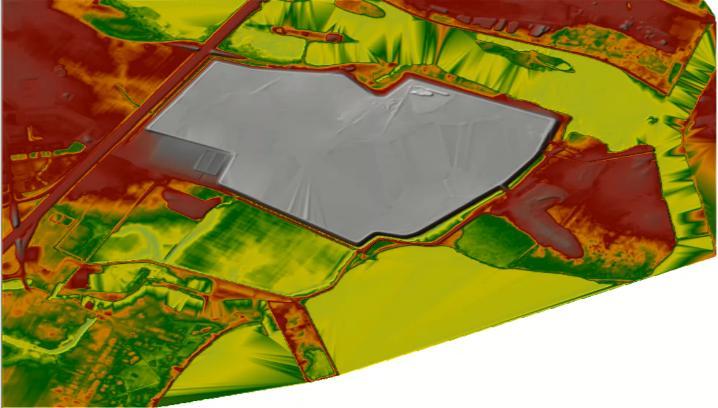
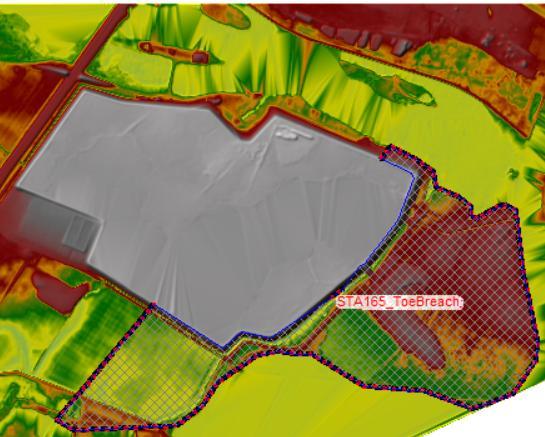
19 Dam Breach Analysis: How would you model this? buildings road multi-sided impoundment road buildings
20 2D Model Setup Elevation Pre-Processing Lidar (Terrain) Floodplain Bathymetry Channel Land Cover Input Mesh Development Boundary Conditions Calculation of Table Properties Model is only as good as the (terrain) data! Very important to have good terrain (DEM) data. Terrain data usually does not include bathymetry. For flood plain studies, not a big problem. For channel flow analysis, bathymetry is very important to get details in river.

21 Elevation Data Pre-Processing Remove redundant data points Produce a bare earth terrain by removing from Lidar Bridge decks Vegetation Trees Overwater passes Superimpose channel bathymetry data Can be done in RAS Mapper/ GIS Source : HECRAS User Manual

22 Elevation Data Pre-Processing Creating a terrain model


23 Land Cover Input Build in GIS import with RAS Mapper (.shp)
24 Mesh Development
25 Boundary Conditions


26 Calculation of Hydraulic Properties RAS uses all the input data to compute hydraulic properties of all cells and cell faces Elevation- Volume relationship created for each cell using the underlying terrain Elevation versus area, wetted perimeter, roughness calculated for each cell face

27 Running a 2D HEC-RAS Running the model Model stability


28 Post Processing Results are viewed in RAS Mapper Animation Note: When checked value is PINK, you can view individual values, min/ max, press play

29 Post Processing Results cab be exported to raster and GIS can take it from there
30 Case study : 1D Vs 2D- Dam Breach
31 Dam Breach Simulation Case Study Dam Breach Analysis Crest length 5200 ft Height - 23 feet, Maximum impoundment area of 10,000 acre-feet Simulated a piping failure for the dam- Sunny Day Peak flow of 17,000 cfs for breach hydrograph

32 1D Model 202 Cross Sections Spaced approx. 800 ft. apart

33 300*300 ft grid cells

34 Results 1D Output results look just as fancy, however 2D More backwater effects and larger depths in 2D case 2D shows more floodplain inundated

35 1D, 1D+2D or pure-2d?! When should you go. Pure 2D: Flow expected to spill into floodplain Alluvial fans and estuaries Meanders and loops Cool hydrodynamic animations! Access to good terrain data Pure 1D: Mostly uni-directional flow within channel Minimum lateral expansion Run time is a constraint Need to extract a lot of data (velocity, Froude #, shear, normal depth, critical depth etc.) Limited/low quality terrain data 1D+2D, when you need both 2D and 1D features Source: HEC-RAS 2D Modeling User s Manual

36 THANK YOU Rishab Mahajan Emily Campbell
Advanced 1D/2D Modeling Using HEC-RAS
 Advanced 1D/2D Modeling Using HEC-RAS Davis, California Objectives This is an advanced course in applying computer program HEC-RAS. The course provides participants with the knowledge to effectively use
Day 1. HEC-RAS 1-D Training. Rob Keller and Mark Forest. Break (9:45 am to 10:00 am) Lunch (12:00 pm to 1:00 pm)
 Lunch (12:00 pm to 1:00 pm)") Day 1 HEC-RAS 1-D Training Rob Keller and Mark Forest Introductions and Course Objectives (8:00 am to 8:15 am) Introductions: Class and Content Module 1 Open Channel Hydraulics (8:15 am to 9:45 am) Lecture
Day 1 HEC-RAS 1-D Training Rob Keller and Mark Forest Introductions and Course Objectives (8:00 am to 8:15 am) Introductions: Class and Content Module 1 Open Channel Hydraulics (8:15 am to 9:45 am) Lecture
2-D Hydraulic Modeling Theory & Practice
 2-D Hydraulic Modeling Theory & Practice Author: Maged A. Aboelata, PhD, PE, CFM Presenter: Heather Zhao, PE, CFM October 2017 Presentation Outline * 1-D vs. 2-D modeling * Theory of 2-D simulation * Commonly
2D Hydraulic Modeling, Steering Stream Restoration Design
 2D Hydraulic Modeling, Steering Stream Restoration Design PREPARED FOR: EcoStream 2018 Stream Ecology & Restoration Conference Presented By: Matthew D. Gramza, P.E., CFM, CPESC Civil & Environmental Consultants,
Connecting 1D and 2D Domains
 Connecting 1D and 2D Domains XP Solutions has a long history of Providing original, high-performing software solutions Leading the industry in customer service and support Educating our customers to be
Appendix E. HEC-RAS and HEC-Ecosystem Functions Models
 Appendix E HEC-RAS and HEC-Ecosystem Functions Models 1 Appendix E: Modeled Reaches for the Connecticut River Watershed application of HEC-RAS Separate from the report for the Decision Support System of
Prof. B.S. Thandaveswara. The computation of a flood wave resulting from a dam break basically involves two
 41.4 Routing The computation of a flood wave resulting from a dam break basically involves two problems, which may be considered jointly or seperately: 1. Determination of the outflow hydrograph from the
Introducion to Hydrologic Engineering Centers River Analysis System (HEC- RAS) Neena Isaac Scientist D CWPRS, Pune -24
 Neena Isaac Scientist D CWPRS, Pune -24") Introducion to Hydrologic Engineering Centers River Analysis System (HEC- RAS) Neena Isaac Scientist D CWPRS, Pune -24 One dimensional river models (1-D models) Assumptions Flow is one dimensional Streamline
Introducion to Hydrologic Engineering Centers River Analysis System (HEC- RAS) Neena Isaac Scientist D CWPRS, Pune -24 One dimensional river models (1-D models) Assumptions Flow is one dimensional Streamline
2014 AWRA Annual Water Resources Conference November 5, 2014 Tysons Corner, VA
 2014 AWRA Annual Water Resources Conference November 5, 2014 Tysons Corner, VA HEC-RAS Overview, History, & Future How HEC-RAS Works Model Development Standard FEMA Assumptions Building A Model FEMA Levels
CHAPTER 7 FLOOD HYDRAULICS & HYDROLOGIC VIVEK VERMA
 CHAPTER 7 FLOOD HYDRAULICS & HYDROLOGIC VIVEK VERMA CONTENTS 1. Flow Classification 2. Chezy s and Manning Equation 3. Specific Energy 4. Surface Water Profiles 5. Hydraulic Jump 6. HEC-RAS 7. HEC-HMS
Harris County Flood Control District HEC-RAS 2D Modeling Guidelines (Standardizing HEC-RAS 2D Models for Submittal Within Harris County)
") Harris County Flood Control District HEC-RAS 2D Modeling Guidelines (Standardizing HEC-RAS 2D Models for Submittal Within Harris County) Presented by: April 27, 2017 Matthew Zeve, P.E., CFM Harris County
Harris County Flood Control District HEC-RAS 2D Modeling Guidelines (Standardizing HEC-RAS 2D Models for Submittal Within Harris County) Presented by: April 27, 2017 Matthew Zeve, P.E., CFM Harris County
Numerical Hydraulics
 ETHZ, Fall 2017 Numerical Hydraulics Assignment 3 Comparison of two numerical solutions of river flow: use of Finite Elements (HEC-RAS) and Finite Volumes (BASEMENT) 1 Introduction In the course, two different
UNDERSTAND HOW TO SET UP AND RUN A HYDRAULIC MODEL IN HEC-RAS CREATE A FLOOD INUNDATION MAP IN ARCGIS.
 CE 412/512, Spring 2017 HW9: Introduction to HEC-RAS and Floodplain Mapping Due: end of class, print and hand in. HEC-RAS is a Hydrologic Modeling System that is designed to describe the physical properties
Linear Routing: Floodrouting. HEC-RAS Introduction. Brays Bayou. Uniform Open Channel Flow. v = 1 n R2/3. S S.I. units
 Linear Routing: Floodrouting HEC-RAS Introduction Shirley Clark Penn State Harrisburg Robert Pitt University of Alabama April 26, 2004 Two (2) types of floodrouting of a hydrograph Linear Muskingum Reservoir
The HEC-RAS Model Refresher
 The HEC-RAS Model Refresher Minmin Shu P.E. Transportation Review Unit Water Resources Division Michigan Department of Environmental Quality 12-6-2018 What Does the HEC-RAS Mean RAS----River Analysis System
Updated on November 10, 2017
 CIVE 7397 Unsteady flows in Rivers and Pipe Networks/Stormwater Management and Modeling / Optimization in Water Resources Engineering Updated on November 10, 2017 Tutorial on using HEC-GeoRAS 10.1 (or
INTRODUCTION TO HEC-RAS
 INTRODUCTION TO HEC-RAS HEC- RAS stands for Hydrologic Engineering Center s River Analysis System By U.S. Army Corps of Engineers One dimensional analysis of : 1. Steady flow 2. Unsteady flow 3. Sediment
Verification and Validation of HEC-RAS 5.1
 Verification and Validation of HEC-RAS 5.1 Gary Brunner 1, P.E., D. WRE, M.ASCE Dr. Alex Sanchez 1 Dr. Tom Molls 2 Dr. David Parr 3 1. USACE Hydrologic Engineering Center, Davis, CA 2. David Ford Consulting
2D Modeling for Approximate Areas. Monica S. Urisko, P.E. CFM
 2D Modeling for Approximate Areas Monica S. Urisko, P.E. CFM Ferrin P. Affleck, P.E. CFM Outline Types of Modeling Available Steady vs Unsteady 1D vs 2D Software available Basics of 2D modeling Inputs
Prepared for CIVE 401 Hydraulic Engineering By Kennard Lai, Patrick Ndolo Goy & Dr. Pierre Julien Fall 2015
 Prepared for CIVE 401 Hydraulic Engineering By Kennard Lai, Patrick Ndolo Goy & Dr. Pierre Julien Fall 2015 Contents Introduction General Philosophy Overview of Capabilities Applications Computational
Introduction Surface Water Modeling System (SMS) & Case Study using SMS 2D Modeling Software
 & Case Study using SMS 2D Modeling Software") A.D. Latornell Conservation Symposium November 18, 2015 Introduction Surface Water Modeling System (SMS) & Case Study using SMS 2D Modeling Software Dr. Bahar SM P.Geo.(Ltd), P Eng 1 Topics Education,
A.D. Latornell Conservation Symposium November 18, 2015 Introduction Surface Water Modeling System (SMS) & Case Study using SMS 2D Modeling Software Dr. Bahar SM P.Geo.(Ltd), P Eng 1 Topics Education,
Comparing 2D Approaches for Complex FEMA Studies
 Comparing 2D Approaches for Complex FEMA Studies Presented by: Ted Cassidy, P.E., PH (STARR2-Dewberry) Sam Crampton, P.E., CFM (STARR2-Dewberry) Mike DePue, P.E., CFM (STARR2-Atkins) Agenda Introduction
A Comparative Study of HEC-RAS 2D, TUFLOW, & Mike 21 Model Benchmark Testing
 A Comparative Study of HEC-RAS 2D, TUFLOW, & Mike 21 Model Benchmark Testing June 2016 Presented by: Murari Paudel, PhD, PE, CFM Soledad B Roman, EIT John Prichard, PE, CFM Wood Rodgers Inc. Sacramento,
Efficiency and Accuracy of Importing HEC RAS Datafiles into PCSWMM and SWMM5
 5 Efficiency and Accuracy of Importing HEC RAS Datafiles into PCSWMM and SWMM5 Karen Finney, Rob James, William James and Tiehong Xiao An advantage of USEPA s SWMM5 is its capability to dynamically model
HEC-RAS 3.0 January, 2001 Release Notes
 HEC-RAS 3.0 January, 2001 Release Notes A new version of HEC-RAS (3.0) has been released with significant new features over the previous version (2.21). Version 3.0 includes unsteady flow routing capabilities,
HEC-RAS Verification and Validation Tests
 HEC-RAS Verification and Validation Tests April 2018 Approved for Public Release. Distribution Unlimited. RD-52 REPORT DOCUMENTATION PAGE Form Approved OMB No. 0704-0188 The public reporting burden for
George Mason University Department of Civil, Environmental and Infrastructure Engineering. Dr. Celso Ferreira
 George Mason University Department of Civil, Environmental and Infrastructure Engineering Dr. Celso Ferreira Exercise Topic: HEC GeoRAS Post-Processing Objectives: This tutorial is designed to walk you
Comparing HEC-RAS v5.0 2-D Results with Verification Datasets
 Comparing HEC-RAS v5.0 2-D Results with Verification Datasets Tom Molls 1, Gary Brunner 2, & Alejandro Sanchez 2 1. David Ford Consulting Engineers, Inc., Sacramento, CA 2. USACE Hydrologic Engineering
SMS v D Summary Table. SRH-2D Tutorial. Prerequisites. Requirements. Time. Objectives
 SMS v. 12.3 SRH-2D Tutorial Objectives Learn the process of making a summary table to compare the 2D hydraulic model results with 1D hydraulic model results. This tutorial introduces a method of presenting
River inundation modelling for risk analysis
 River inundation modelling for risk analysis L. H. C. Chua, F. Merting & K. P. Holz Institute for Bauinformatik, Brandenburg Technical University, Germany Abstract This paper presents the results of an
Hydraulic Modeling with HEC RAS. Susan Cundiff, PE December 4, 2017
 Hydraulic Modeling with HEC RAS Susan Cundiff, PE December 4, 2017 Overview Introduction to HEC RAS Computational Procedures Building a Model Example Projects Introduction to HEC RAS U.S. Army Corps of
2D Model Implementation for Complex Floodplain Studies. Sam Crampton, P.E., CFM Dewberry
 2D Model Implementation for Complex Floodplain Studies Sam Crampton, P.E., CFM Dewberry 2D Case Studies Case Study 1 Rain-on-Grid 2D floodplain simulation for unconfined flat topography in coastal plain
This tutorial introduces the HEC-RAS model and how it can be used to generate files for use with the HEC-RAS software.
 v. 12.3 SMS 12.3 Tutorial Objectives This tutorial introduces the model and how it can be used to generate files for use with the software. Prerequisites Overview Tutorial Requirements 5.0 Mesh Module
Steady Flow Water Surface Profile Computation Using HEC-RAS
 Steady Flow Water Surface Profile Computation Using HEC-RAS Objectives The objective of the course is to enable the participants to perform water surface profile computations using computer program HEC-RAS
Using HEC-RAS and HEC-GeoRAS for River Modeling Adapted by E. Maurer, using an exercise by V. Merwade, Purdue Univ.
 Introduction Using HEC-RAS and HEC-GeoRAS for River Modeling Adapted by E. Maurer, using an exercise by V. Merwade, Purdue Univ. This tutorial uses the output from HEC_GeoRAS from a prior exercise as input
Urban Floodplain modeling- Application of Two-Dimensional Analyses to Refine Results
 Urban Floodplain modeling- Application of Two-Dimensional Analyses to Refine Results Prabharanjani Madduri, P.E., CFM Mathini Sreetharan, Ph.D., P.E., CFM Hydraulic modeling of urban areas and issues Modeling
Rapid Floodplain Delineation. Presented by: Leo R. Kreymborg 1, P.E. David T. Williams 2, Ph.D., P.E. Iwan H. Thomas 3, E.I.T.
 007 ASCE Rapid Floodplain Delineation Presented by: Leo R. Kreymborg 1, P.E. David T. Williams, Ph.D., P.E. Iwan H. Thomas 3, E.I.T. 1 Project Manager, PBS&J, 975 Sky Park Court, Suite 00, San Diego, CA
v TUFLOW-2D Hydrodynamics SMS Tutorials Time minutes Prerequisites Overview Tutorial
 v. 12.2 SMS 12.2 Tutorial TUFLOW-2D Hydrodynamics Objectives This tutorial describes the generation of a TUFLOW project using the SMS interface. This project utilizes only the two dimensional flow calculation
UNCERTAINTY ISSUES IN HYDRODYNAMIC FLOOD MODELING
 UNCERTAINTY ISSUES IN HYDRODYNAMIC FLOOD MODELING Alemseged T. H. a and T. H. M. Rientjes b a Department of Water Resources, ITC, P.O.Box 6, 7500AA, Enschede, The Netherlands. E-mail: haile07634@itc.nl
Introduction to MIKE FLOOD
 Introduction to MIKE FLOOD HYDROEUROPE, Sophia-Antipolis, February 2011 Julie Landrein, DHI Denmark Introduction to MIKE FLOOD - Introduction to MIKE FLOOD - 1D Modelling: MIKE 11, MIKE URBAN - 2D Modelling:
Flood Inundation Mapping using HEC-RAS
 Flood Inundation Mapping using HEC-RAS Goodell, C. 1 ; Warren, C. 2 WEST Consultants, 2601 25 th St SE, Suite 450, Salem, OR 97302. Abstract Flood inundation mapping is an important tool for municipal
v SMS Tutorials SRH-2D Prerequisites Requirements SRH-2D Model Map Module Mesh Module Data files Time
 v. 11.2 SMS 11.2 Tutorial Objectives This tutorial shows how to build a Sedimentation and River Hydraulics Two-Dimensional () simulation using SMS version 11.2 or later. Prerequisites SMS Overview tutorial
This tutorial shows how to build a Sedimentation and River Hydraulics Two-Dimensional (SRH-2D) simulation. Requirements
 simulation. Requirements") v. 13.0 SMS 13.0 Tutorial Objectives This tutorial shows how to build a Sedimentation and River Hydraulics Two-Dimensional () simulation. Prerequisites SMS Overview tutorial Requirements Model Map Module
v. 13.0 SMS 13.0 Tutorial Objectives This tutorial shows how to build a Sedimentation and River Hydraulics Two-Dimensional () simulation. Prerequisites SMS Overview tutorial Requirements Model Map Module
CEE Special Seminar. The Oroville Dam Incident: Insights and Implications for Risk Management and Community Resilience
 CEE Special Seminar The Oroville Dam Incident: Insights and Implications for Risk Management and Community Resilience Stanford Risk Symposium Sponsored by the National Performance of Dams Program and the
Objectives This tutorial shows how to build a Sedimentation and River Hydraulics Two-Dimensional (SRH-2D) simulation.
 simulation.") v. 12.1 SMS 12.1 Tutorial Objectives This tutorial shows how to build a Sedimentation and River Hydraulics Two-Dimensional () simulation. Prerequisites SMS Overview tutorial Requirements Model Map Module
v. 12.1 SMS 12.1 Tutorial Objectives This tutorial shows how to build a Sedimentation and River Hydraulics Two-Dimensional () simulation. Prerequisites SMS Overview tutorial Requirements Model Map Module
HEC-RAS. A Tutorial (Model Development of a Small Flume)
") HEC-RAS A Tutorial (Model Development of a Small Flume) HEC-RAS Hydraulic Engineering Center:River Analysis System 1-D step backwater model Utilizes energy equation to compute water surface elevation for
HEC-RAS A Tutorial (Model Development of a Small Flume) HEC-RAS Hydraulic Engineering Center:River Analysis System 1-D step backwater model Utilizes energy equation to compute water surface elevation for
ISIS 1D. Quick Start Guide. Cost effective, integrated software solutions ch2mhill.com/isis
 ISIS 1D Quick Start Guide Cost effective, integrated software solutions 0845 094 7990 ch2mhill.com/isis softwaresupport@ch2m.com Table of Contents Overview... 3 1. Starting ISIS and Basic Concepts... 3
ENV3104 Hydraulics II 2017 Assignment 1. Gradually Varied Flow Profiles and Numerical Solution of the Kinematic Equations:
 ENV3104 Hydraulics II 2017 Assignment 1 Assignment 1 Gradually Varied Flow Profiles and Numerical Solution of the Kinematic Equations: Examiner: Jahangir Alam Due Date: 27 Apr 2017 Weighting: 1% Objectives
Lidar and GIS: Applications and Examples. Dan Hedges Clayton Crawford
 Lidar and GIS: Applications and Examples Dan Hedges Clayton Crawford Outline Data structures, tools, and workflows Assessing lidar point coverage and sample density Creating raster DEMs and DSMs Data area
FLOODPLAIN MODELING USING HEC-RAS
 H A E S T A D M E T H O D S FLOODPLAIN MODELING USING HEC-RAS F i r s t E d i t i o n Authors Haestad Methods Gary Dyhouse Jennifer Hatchett Jeremy Benn Managing Editor Colleen Totz Editors David Klotz,
2D Large Scale Automated Engineering for FEMA Floodplain Development in South Dakota. Eli Gruber, PE Brooke Conner, PE
 2D Large Scale Automated Engineering for FEMA Floodplain Development in South Dakota Eli Gruber, PE Brooke Conner, PE Project Acknowledgments FEMA Region 8 Staff: Brooke Conner, PE Casey Zuzak, GISP Ryan
INTERNATIONAL JOURNAL OF CIVIL AND STRUCTURAL ENGINEERING Volume 2, No 3, 2012
 INTERNATIONAL JOURNAL OF CIVIL AND STRUCTURAL ENGINEERING Volume 2, No 3, 2012 Copyright 2010 All rights reserved Integrated Publishing services Research article ISSN 0976 4399 Efficiency and performances
Comparison of 1D and 2D Surface Water Models for Solid Waste Facilities. Garth R. Bowers, P.E., Carl E. Bueter, P.E., Larry Henk
 Comparison of 1D and 2D Surface Water Models for Solid Waste Facilities Garth R. Bowers, P.E., Carl E. Bueter, P.E., Larry Henk Introduction Importance of Accurate Floodplain Delineation Required by Federal
WMS 10.1 Tutorial Hydraulics and Floodplain Modeling HEC-RAS Analysis Learn how to setup a basic HEC-RAS analysis using WMS
 v. 10.1 WMS 10.1 Tutorial Hydraulics and Floodplain Modeling HEC-RAS Analysis Learn how to setup a basic HEC-RAS analysis using WMS Objectives Learn how to build cross sections, stream centerlines, and
COMPARISON OF NUMERICAL HYDRAULIC MODELS APPLIED TO THE REMOVAL OF SAVAGE RAPIDS DAM NEAR GRANTS PASS, OREGON
 COMPARISON OF NUMERICAL HYDRAULIC MODELS APPLIED TO THE REMOVAL OF SAVAGE RAPIDS DAM NEAR GRANTS PASS, OREGON Jennifer Bountry, Hydraulic Engineer, Bureau of Reclamation, Denver, CO, jbountry@do.usbr.gov;
HEC-RAS 2D Flood Modelling Tutorial
 HEC-RAS 2D Flood Modelling Tutorial Civil Site Design and HECRAS 2D Flood Modelling HECRAS version 5 and later includes functionality to analyse water flows moving across a surface. this is known as 2D
WMS 9.0 Tutorial Hydraulics and Floodplain Modeling HEC-RAS Analysis Learn how to setup a basic HEC-RAS analysis using WMS
 v. 9.0 WMS 9.0 Tutorial Hydraulics and Floodplain Modeling HEC-RAS Analysis Learn how to setup a basic HEC-RAS analysis using WMS Objectives Learn how to build cross sections, stream centerlines, and bank
Objectives This tutorial demonstrates how to perform unsteady sediment transport simulations in SRH-2D.
 SMS v. 12.2 SRH-2D Tutorial Objectives This tutorial demonstrates how to perform unsteady sediment transport simulations in SRH-2D. Prerequisites SMS Overview tutorial SRH-2D SRH-2D Sediment Transport
Edward G. Beadenkopf, PE, CFM RAMPP-URS Corporation
 FEMA and Multi-Federal Agency Cooperation to Support Dam Safety and to Develop Tools for States and Local Communities to Create More Resilient Communities Edward G. Beadenkopf, PE, CFM RAMPP-URS Corporation
HEC-RAS River Analysis System
 HEC-RAS River Analysis System Supplemental to HEC-RAS Version 5.0 User's Manual Version 5.0.4 April 2018 Approved for Public Release. Distribution Unlimited. CPD-68d REPORT DOCUMENTATION PAGE Form Approved
The CaMa-Flood model description
 Japan Agency for Marine-Earth cience and Technology The CaMa-Flood model description Dai Yamazaki JAMTEC Japan Agency for Marine-Earth cience and Technology 4 th ep, 2015 Concepts of the CaMa-Flood development
Chapter 3 2D flood modelling with Delft-FLS
 Chapter 3 2D flood modelling with Delft-FLS The previous chapter presented the conceptual framework for hazard and risk assessment. This chapter will deal with an important tool for simulating flood events
Gavin Fields Senior Water Resources Engineer XP Solutions
 Hydraulics 101 Gavin Fields Senior Water Resources Engineer XP Solutions Hydraulics 101 Introduction Structures Hydraulic Model Building Q&A XP Solutions Software for modeling wastewater, stormwater, and
GPU - Next Generation Modeling for Catchment Floodplain Management. ASFPM Conference, Grand Rapids (June 2016) Chris Huxley
 Chris Huxley") GPU - Next Generation Modeling for Catchment Floodplain Management ASFPM Conference, Grand Rapids (June 2016) Chris Huxley Presentation Overview 1. What is GPU flood modeling? 2. What is possible using
GPU - Next Generation Modeling for Catchment Floodplain Management ASFPM Conference, Grand Rapids (June 2016) Chris Huxley Presentation Overview 1. What is GPU flood modeling? 2. What is possible using
RESCDAM DEVELOPMENT OF RESCUE ACTIONS BASED ON DAM BREAK FLOOD ANALYSI A PREVENTION PROJECT UNDER THE EUROPEAN COMMUNITY ACTION PROGRAMME
 RESCDAM DEVELOPMENT OF RESCUE ACTIONS BASED ON DAM BREAK FLOOD ANALYSI A PREVENTION PROJECT UNDER THE EUROPEAN COMMUNITY ACTION PROGRAMME 1-DIMENSIONAL FLOW SIMULATIONS FOR THE KYRKÖSJÄRVI DAM BREAK HAZARD
AUTOMATING MANNING S N COEFFICIENT VALUE ASSIGNMENTS FOR HYDRAULIC MODELING
 Imagery Source: Bing Maps via ESRI AUTOMATING MANNING S N COEFFICIENT VALUE ASSIGNMENTS FOR HYDRAULIC MODELING Kyle Gallagher, GISP Black & Veatch Special Projects Corp. Project Overview USACE Tulsa District
Staying ahead of the flood. The influence of higher resolution flood simulation models on the accuracy and visualisation of information.
 Master Thesis Olga Pleumeekers TU Delft and Nelen & Schuurmans The influence of higher resolution flood simulation models on the accuracy and visualisation of information Master Thesis The influence of
Using 2D Schemes to Model Energy Losses at Structures and Bends Beware of Pretty Images!
 Using 2D Schemes to Model Energy Losses at Structures and Bends Beware of Pretty Images! Bill Syme BMT WBM Software Business Manager 2D: Looks impressive, but is it accurate? 2 Form Losses Energy dissipated
TUFLOW 1D/2D SURFACE WATER MODELING SYSTEM. 1 Introduction. 2 Background Data
 SURFACE WATER MODELING SYSTEM TUFLOW 1D/2D 1 Introduction This tutorial describes the generation of a 1D TUFLOW project using the SMS interface. It is recommended that the TUFLOW 2D tutorial be done before
Application of 2-D Modelling for Muda River Using CCHE2D
 Application of 2-D Modelling for Muda River Using CCHE2D ZORKEFLEE ABU HASAN, Lecturer, River Engineering and Urban Drainage Research Centre (REDAC), Universiti Sains Malaysia, Engineering Campus, Seri
TUFLOW Two & one-dimensional Unsteady FLOW Software for Rivers, Estuaries and Coastal Waters
 TUFLOW Two & one-dimensional Unsteady FLOW Software for Rivers, Estuaries and Coastal Waters W.J.Syme B.E.(Hons), M.Eng.Sc.(Res) - WBM Oceanics Australia Summary: Once limited to coastal hydraulics, two-dimensional
v TUFLOW 1D/2D SMS 11.2 Tutorial Time minutes Prerequisites TUFLOW 2D Tutorial
 v. 11.2 SMS 11.2 Tutorial Objectives This tutorial describes the generation of a 1D TUFLOW project using the SMS interface. It is strongly recommended that the TUFLOW 2D tutorial be completed before doing
HEC RAS 2D Methods Guidance: South Dakota Large Scale Automated Engineering
 HEC RAS 2D Methods Guidance: South Dakota Large Scale Automated Engineering January, 2017 Prepared by: Compass PTS JV a JV led by AECOM and CDM Smith 3101 Wilson Boulevard, Suite 900 Arlington, VA 22201
FLOODPLAIN MODELING MANUAL. HEC-RAS Procedures for HEC-2 Modelers
 FLOODPLAIN MODELING MANUAL HEC-RAS Procedures for HEC-2 Modelers Federal Emergency Management Agency Mitigation Directorate 500 C Street, SW Washington, DC 20472 April 2002 Floodplain Modeling Manual HEC-RAS
Generalisation of Topographic resolution for 2D Urban Flood Modelling. Solomon D. Seyoum Ronald Price Zoran Voijnovic
 Generalisation of Topographic resolution for 2D Urban Flood Modelling Solomon D. Seyoum Ronald Price Zoran Voijnovic Outline Introduction Urban Flood Modelling and Topographic data DTM Generalisation Remedial
Boundaries of 1D 2D modelling. Suzanne Callaway Senior Hydraulic Modeller
 Boundaries of 1D 2D modelling Suzanne Callaway Senior Hydraulic Modeller Introduction Why is it important to define 1D 2D boundaries carefully? Defining boundaries between 1D and 2D models (Flood Modeller
Numerical Simulation of Flood Wave Spreading in 2D in Densely Populated Urban Areas due to Dam Break
 Numerical Simulation of Flood Wave Spreading in 2D in Densely Populated Urban Areas due to Dam Break Ismail Haltas 1,Sebnem Elçi 2 and Gokmen Tayfur 3* Abstract: Dams are important structures having many
Floodplain Engineering
 Floodplain Engineering by David E. Fantina, PE Introduction: This course presents a discussion of the modeling procedure for flood profiling. The most commonly used software for flood profiling is the
Flood Routing for Continuous Simulation Models
 Improving Life through Science and Technology Flood Routing for Continuous Simulation Models J. Williams, W. Merkel, J. Arnold, J. Jeong 11 International SWAT Conference, Toledo, Spain, June 15-17, 11
Reality Check: Processing LiDAR Data. A story of data, more data and some more data
 Reality Check: Processing LiDAR Data A story of data, more data and some more data Red River of the North Red River of the North Red River of the North Red River of the North Introduction and Background
Upper Trinity River Corridor Development Certificate Model Updates. Flood Management Task Force Meeting April 20, 2018
 Upper Trinity River Corridor Development Certificate Model Updates Flood Management Task Force Meeting April 20, 2018 Agenda Review of the Phase II Upper Trinity Watershed CDC Model Development Hydrology
HEC-RAS River Analysis System
 HEC-RAS River Analysis System 2D Modeling User's Manual Version 5.0 February 2016 Approved for Public Release. Distribution Unlimited. CPD-68A REPORT DOCUMENTATION PAGE Form Approved OMB No. 0704-0188
River Analysis System HEC-RAS
 Hydrologic Engineering Center River Analysis System HEC-RAS Release Notes Version 5.0.2 August 2016 Approved for Public Release Distribution Unlimited 1 Introduction Version 5.0.2 of the River Analysis
PRACTICAL UNIT 1 exercise task
 Practical Unit 1 1 1 PRACTICAL UNIT 1 exercise task Developing a hydraulic model with HEC RAS using schematic river geometry data In the course of practical unit 1 we prepare the input for the execution
A practical approach to floodplain mapping for large-scale catastrophe models
 Flood Recovery, Innovation and Reponse IV 49 A practical approach to floodplain mapping for large-scale catastrophe models I. Carnacina & A. Jemberie Research and Modeling, AIR Worldwide, USA Abstract
A fuzzy dynamic flood routing model for natural channels
 HYDROLOGICAL PROCESSES Hydrol. Process. (29) Published online in Wiley InterScience (www.interscience.wiley.com) DOI:.2/hyp.73 A fuzzy dynamic flood routing model for natural channels R. Gopakumar and
WMS 9.1 Tutorial Hydraulics and Floodplain Modeling Floodplain Delineation Learn how to us the WMS floodplain delineation tools
 v. 9.1 WMS 9.1 Tutorial Hydraulics and Floodplain Modeling Floodplain Delineation Learn how to us the WMS floodplain delineation tools Objectives Experiment with the various floodplain delineation options
2D Hydrodynamic Model for Reservoirs: Case Study High Aswan Dam Reservoir
 D Hydrodynamic Model for Reservoirs: Case Study High Aswan Dam Reservoir M. M. Soliman 1, M. A. Gad, Ashraf M. El-Moustafa 3 Abstract High Aswan Dam (HAD) is one of the most important projects in the history
2015 HDR, all rights reserved.
 2015 HDR, all rights reserved. An Alternative to HEC-GEORAS: Overview & Comparison of AutoCAD River & Flood Analysis Module Ron Branyon, PE, CFM George Doubleday, EIT, CFM Brandon Hilbrich, PE, CFM TFMA
Watershed Analysis with the Hydrologic Engineering Center s River Analysis System (HEC-RAS)
") Watershed Analysis with the Hydrologic Engineering Center s River Analysis System (HEC-RAS) by Christopher R. Goodell and Gary W. Brunner PURPOSE: The objectives of this document are to provide a general
Watershed Analysis with the Hydrologic Engineering Center s River Analysis System (HEC-RAS) by Christopher R. Goodell and Gary W. Brunner PURPOSE: The objectives of this document are to provide a general
Flood routing modelling with Artificial Neural Networks
 Adv. Geosci., 9, 131 136, 2006 Author(s) 2006. This work is licensed under a Creative Commons License. Advances in Geosciences Flood routing modelling with Artificial Neural Networks R. Peters, G. Schmitz,
HEC-RAS River Analysis System
 HEC-RAS River Analysis System Version 5.0.7 March 2019 Approved for Public Release. Distribution Unlimited. Introduction Version 5.0.7 of the River Analysis System (HEC-RAS) is now available. This Version
Cloud-Computing Based Real-Time Flood Simulation (RealFlood Engine)
") Cloud-Computing Based Real-Time Flood Simulation (RealFlood Engine) Jennifer G Duan, PhD., PE Principal, KKC Engineering (UA Tech Launch) Associate Professor Delbert R. Lewis Distinguished Professor Civil
Cloud-Computing Based Real-Time Flood Simulation (RealFlood Engine) Jennifer G Duan, PhD., PE Principal, KKC Engineering (UA Tech Launch) Associate Professor Delbert R. Lewis Distinguished Professor Civil
Cross Sections, Profiles, and Rating Curves. Viewing Results From The River System Schematic. Viewing Data Contained in an HEC-DSS File
 C H A P T E R 9 Viewing Results After the model has finished the steady or unsteady flow computations the user can begin to view the output. Output is available in a graphical and tabular format. The current
XP Solutions has a long history of Providing original, high-performing software solutions Leading the industry in customer service and support
 XP Solutions has a long history of Providing original, high-performing software solutions Leading the industry in customer service and support Educating our customers to be more successful in their work.
BDCP Effects Analysis: 2D Hydrodynamic Modeling of the Fremont Weir Diversion Structure
 Hydrology Hydraulics Geomorphology Design Field Services BDCP Effects Analysis: 2D Hydrodynamic Modeling of the Fremont Weir Diversion Structure Prepared for SAIC and the California Department of Water
HCFCD Review Process
 HCFCD Review Process Impact Analysis Local Review LOMR Delegation Local Review This presentation will include: Why is this step important? Process Review Checklist Common Comments 2 Local Review Why is
The TUFLOW Link. Past, Present and Future. Stephanie Dufour
 The TUFLOW Link Past, Present and Future Stephanie Dufour stephanie.dufour@bmtwbm.co.uk Contents PAST Software background Thames Embayments Inundation Study PRESENT Flood Modeller -TUFLOW link Flood Modeller
Application Description
 USER S GUIDE FOR SDB GUI (SDB-J) Modifications by Janice Sylvestre Based on NWS Document THE NWS SIMPLIFIED DAM-BREAK FLOOD FORECASTING MODEL 1 By Danny L. Fread, Janice M. Lewis, and Stephen M. Wiele
v. 9.1 WMS 9.1 Tutorial Watershed Modeling HEC-1 Interface Learn how to setup a basic HEC-1 model using WMS
 v. 9.1 WMS 9.1 Tutorial Learn how to setup a basic HEC-1 model using WMS Objectives Build a basic HEC-1 model from scratch using a DEM, land use, and soil data. Compute the geometric and hydrologic parameters