Building Information Modeling (BIM) and Measuring Techniques
|
|
|
- Ashlyn Tucker
- 6 years ago
- Views:
Transcription


1 Building Information Modeling (BIM) and Measuring Techniques Christian CLEMEN, Robert EHRICH and Christopher VAN ZYL, Germany C. Clemen, R. Ehrich,C. van Zyl Building Information Model (BIM) and Measuring Techniques, XXV FIG Congress, Kuala Lumpur, Malaysia Seite 1/23 Project: As-built survey for BIM Copyright for images (BMB GmbH and HTW-Dresden) C. Clemen, R. Ehrich,C. van Zyl Building Information Model (BIM) and Measuring Techniques, XXV FIG Congress, Kuala Lumpur, Malaysia Seite 2/23
 C. Clemen, R. Ehrich,C.")
 object attributes. Models with no support of behavior.")

2 Project: As-built survey for BIM Step 1 Semantic homogenization: Consistent CAD layers in all files. Digitalization and georeferencing analog and raster data. Survey: Tacheometry and laser scanning for outside areas Copyright for images (BMB GmbH, HTW-Dresden, trimble and faro) C. Clemen, R. Ehrich,C. van Zyl Building Information Model (BIM) and Measuring Techniques, XXV FIG Congress, Kuala Lumpur, Malaysia Seite 3/23 Project: As-built survey for BIM Step 2 What is NOT a BIM? [Eastman, p.19] Models that contain 3D data only and (or few) object attributes. Models with no support of behavior. (no parametric intelligence) Models that are composed of multiple 2D CAD reference files that must be combined to define the building. Models that allow changes to dimensions in one view that are not automatically reflected in other views. Eastmann et.al., BIM Handbook: A Guide to Building Information Modeling for Owners, Managers, Designers, Engineers and Contractors, 2nd Edition, 2011 C. Clemen, R. Ehrich,C. van Zyl Building Information Model (BIM) and Measuring Techniques, XXV FIG Congress, Kuala Lumpur, Malaysia Seite 4/23

 and Measuring")


3 Project: As-built survey for BIM Step 2 BIM - Model Sections & Views Tables Specialized Data C. Clemen, R. Ehrich,C. van Zyl Building Information Model (BIM) and Measuring Techniques, XXV FIG Congress, Kuala Lumpur, Malaysia Seite 5/23 CAD vs. BIM: Impact on as-built surveying 1. Semantics 2. Geometry 3. Technical Project Management C. Clemen, R. Ehrich,C. van Zyl Building Information Model (BIM) and Measuring Techniques, XXV FIG Congress, Kuala Lumpur, Malaysia Seite 6/23
 and Measuring Techniques, XXV FIG Congress, Kuala Lumpur, Malaysia Seite 7/23 CAD vs.")
 3. Conflicts are reported immediately.")
 and Measuring Techniques, XXV FIG Congress, Kuala Lumpur, Malaysia Seite 8/23")
4 CAD vs. BIM - Impact on as-built surveying Semantic Modeling (product model) Working Method: identification and specification of new types (e.g. doors, windows) data acquisition includes semantics (columns, beam) with BIM, CAD- drawing becomes real modeling. C. Clemen, R. Ehrich,C. van Zyl Building Information Model (BIM) and Measuring Techniques, XXV FIG Congress, Kuala Lumpur, Malaysia Seite 7/23 CAD vs. BIM - Impact on as-built surveying Parametric Object Modeling Rule based control (e.g. windows must not overlap each other) Semantic object definition is strictly linked to geometry with the set of parameters. Working Method: 1. Specification of object type 2. Enter measured dimensions and specify topological relations (graphically) 3. Conflicts are reported immediately. Model is always consistent. Drawback: Geometric variations are not easy to model. Better use CAD for historic buildings. C. Clemen, R. Ehrich,C. van Zyl Building Information Model (BIM) and Measuring Techniques, XXV FIG Congress, Kuala Lumpur, Malaysia Seite 8/23

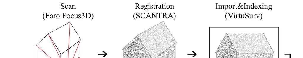
5 CAD vs. BIM - Impact on as-built surveying Technical Project Management Goal consistent model automatically updated views Way of working check-in surveying results check-out for stake-out and model update (changes) Prerequisites nonredundant object modelling associated data and rules C. Clemen, R. Ehrich,C. van Zyl Building Information Model (BIM) and Measuring Techniques, XXV FIG Congress, Kuala Lumpur, Malaysia Seite 9/23 BIM and Measuring Techniques 1. Tacheometry 2. Laser scanning (point cloud) 3. Laser scanning (registered scan view) C. Clemen, R. Ehrich,C. van Zyl Building Information Model (BIM) and Measuring Techniques, XXV FIG Congress, Kuala Lumpur, Malaysia Seite 10/23
 2.")


 C. Clemen, R. Ehrich,C.")
6 Tacheometry (3D-buildung survey) 1. Polar Survey with point codes Consistent spatial reference Code (Window, Wall, Fence, ) 2. Constraints and Fitting planar (points in plane) rectangular (wall-ceiling, wall-wall) 3. Derivation of building element parameters Directly measured or COGO / CAD pick off 4. CAD to BIM Sematics from layer Object geometry frompoints and lines! BIM-site model imports point coordinates directly and generates DTM. C. Clemen, R. Ehrich,C. van Zyl Building Information Model (BIM) and Measuring Techniques, XXV FIG Congress, Kuala Lumpur, Malaysia Seite 11/23 Laser scanning - point cloud (1/4) C. Clemen, R. Ehrich,C. van Zyl Building Information Model (BIM) and Measuring Techniques, XXV FIG Congress, Kuala Lumpur, Malaysia Seite 12/23
 and Measuring Techniques, XXV FIG Congress,")

7 Laser scanning - point cloud (2/4) C. Clemen, R. Ehrich,C. van Zyl Building Information Model (BIM) and Measuring Techniques, XXV FIG Congress, Kuala Lumpur, Malaysia Seite 13/23 Laser scanning - point cloud (3/4) C. Clemen, R. Ehrich,C. van Zyl Building Information Model (BIM) and Measuring Techniques, XXV FIG Congress, Kuala Lumpur, Malaysia Seite 14/23
 and Measuring Techniques, XXV FIG")
 3.")

8 Laser scanning - point cloud (4/4) C. Clemen, R. Ehrich,C. van Zyl Building Information Model (BIM) and Measuring Techniques, XXV FIG Congress, Kuala Lumpur, Malaysia Seite 15/23 BIM and Measuring Techniques 1. Tacheometry 2. Laser scanning (point cloud) 3. Laser scanning (registered scan view) (Software: VirtuSurv by kubit) C. Clemen, R. Ehrich,C. van Zyl Building Information Model (BIM) and Measuring Techniques, XXV FIG Congress, Kuala Lumpur, Malaysia Seite 16/23


9 Laser scanning - registered scan view Geometry Topology C. Clemen, R. Ehrich,C. van Zyl Building Information Model (BIM) and Measuring Techniques, XXV FIG Congress, Kuala Lumpur, Malaysia Seite 17/23 Laser scanning - registered scan view C. Clemen, R. Ehrich,C. van Zyl Building Information Model (BIM) and Measuring Techniques, XXV FIG Congress, Kuala Lumpur, Malaysia Seite 18/23


10 Laser scanning - registered scan view C. Clemen, R. Ehrich,C. van Zyl Building Information Model (BIM) and Measuring Techniques, XXV FIG Congress, Kuala Lumpur, Malaysia Seite 19/23 Laser scanning - registered scan view C. Clemen, R. Ehrich,C. van Zyl Building Information Model (BIM) and Measuring Techniques, XXV FIG Congress, Kuala Lumpur, Malaysia Seite 20/23
11 BIM BIM - Model Sections & Views Tables Specialized Data C. Clemen, R. Ehrich,C. van Zyl Building Information Model (BIM) and Measuring Techniques, XXV FIG Congress, Kuala Lumpur, Malaysia Seite 21/23 Conclusion BIM will not replace CAD. But BIM is getting very important, also for as-built surveys. Real BIM: object oriented product model parametric modeling shared product model Conventional CAD-surveying techniques are to be adapted to the BIM-method. C. Clemen, R. Ehrich,C. van Zyl Building Information Model (BIM) and Measuring Techniques, XXV FIG Congress, Kuala Lumpur, Malaysia Seite 22/23
12 Contact Prof. Dr. - Ing. Christian Clemen Fachgebiet CAD und Virtual Reality / Chair of CAD and Virtual Reality Fakultät Geoinformation / Faculty of Geoinformation HTW Dresden / Dresden University of Applied Sciences Friedrich-List-Platz 1 D Dresden Germany Raum/Office: Z 726 (Zentralgebäude/Main building) Tel: Fax: christian. clemen ( at the ) htw - dresden. de C. Clemen, R. Ehrich,C. van Zyl Building Information Model (BIM) and Measuring Techniques, XXV FIG Congress, Kuala Lumpur, Malaysia Seite 23/23
Building Information Model (BIM) and Measuring Techniques
 and Measuring Techniques") Building Information Model (BIM) and Measuring Techniques Christian CLEMEN, Robert EHRICH and Christopher van Zyl, Germany Keywords: BIM, CAD, Parametric Modeling, Laser Scanning SUMMARY In CAD software
Building Information Model (BIM) and Measuring Techniques Christian CLEMEN, Robert EHRICH and Christopher van Zyl, Germany Keywords: BIM, CAD, Parametric Modeling, Laser Scanning SUMMARY In CAD software
Reverse Engineering for Generation of 3D-Building-Information-Models Applying Random Variables in Computer Aided Design
 Reverse Engineering for Generation of 3D-Building-Information-Models Applying Random Variables in Christian CLEMEN, Frank GIELSDORF and Lothar GRÜNDIG, Germany Key words: CAD, Building Information Model,
Plane Based Free Stationing for Building Models
 Christian MANTHE, Germany Key words: plane based building model, plane detection, plane based transformation SUMMARY 3D Building models are used to construct, manage and rebuild buildings. Thus, associated
The Industry Foundation Classes (IFC) Ready for Indoor Cadastre?
 Ready for Indoor Cadastre?") The Industry Foundation Classes (IFC) Ready for Indoor Cadastre? Christian CLEMEN, Lothar GRÜNDIG, Germany Key words: IFC, AEC, Standards, Interoperability, CAD, Building Information Model. SUMMARY The
The Industry Foundation Classes (IFC) Ready for Indoor Cadastre? Christian CLEMEN, Lothar GRÜNDIG, Germany Key words: IFC, AEC, Standards, Interoperability, CAD, Building Information Model. SUMMARY The
3D Building Information Efficiently Acquired and Managed
 Technische Universität Berlin Department Chair of of Engineering Surveying and and Adjustment Techniques 3D Building Information Efficiently Acquired and Managed Lothar Gründig, Christian Clemen Chair
Room-Element-Aggregation Algorithm to Enhance the Quality of Observed 3D Building Information
 Technische Universität Berlin Room-Element-Aggregation Algorithm to Enhance the Quality of Observed 3D Building Information Christian Manthe Department for Geodesy and Geoinformation Science Technische
With FARO PointSense for Revit. Jörg Braunes Platform Owner Software Chris Palmer Sales Engineer 1
 From Point Clouds to BIM Models With FARO PointSense for Revit Jörg Braunes Platform Owner Software Chris Palmer Sales Engineer 1 Agenda Scan to BIM with Revit PointClouds in Revit Advanced Workflow with
3D Laser Scanning Approaches and Business Models for implementing BIM in Facility Management
 3D Laser Scanning Approaches and Business Models for implementing BIM in Facility Management M.Sc. Zsuzsa Besenyői, HTW Berlin Prof. Dr.-Ing. Markus Krämer, HTW Berlin Dipl.-Ing. (FH) Frank Lindner, G2Plus
Terrestrial Laser Scanning Applied for Reverse Engineering and Monitoring of Historical Buildings
 Terrestrial Laser Scanning Applied for Reverse Engineering and Monitoring of Historical Buildings Ivo MILEV and Lothar GRUENDIG, Germany Keywords: Terrestrial Laser scanning for engineering survey, site
A New Approach for Data Conversion from CAD to GIS
 Esin Bitik (PhD) Dursun Zafer Şeker Ziyadin ÇAKIR Hakan DENLİ A New Approach for Data Conversion from CAD to GIS June 19, 2014 Contents 1. Aim of the study 2. Introduction 3. Vector Data Structure 4. Converting
VISUALIZATION OF GEOINFORMATION IN DAM DEFORMATION MONITORING
 VISUALIZATION OF GEOINFORMATION IN DAM DEFORMATION MONITORING Gergana Antova Abstract This paper introduces laser scanning as an instrument which may be applicable to the field of dam deformation monitoring.
3D Terrestrial Laser Scanner Innovative Applications for 3D Documentation
 3D Terrestrial Laser Scanner Innovative Applications for 3D Documentation Rodney Chaffee Head of Sales, FARO Asia Pacific 3D Laser Scaning Market 2017 2.3 Billion $ 2012 1.3 Billion $ CAGR : > 12% Source:
Trimble Realworks Software
 TECHNICAL NOTES Trimble Realworks Software A Powerful 3D Laser Scanning Office Software Suite DESIGNED FOR TODAY S MULTIFACETED SCANNING PROFESSIONAL, TRIMBLE REALWORKS IS A POWERFUL OFFICE SOFTWARE THAT
Building Reliable 2D Maps from 3D Features
 Building Reliable 2D Maps from 3D Features Dipl. Technoinform. Jens Wettach, Prof. Dr. rer. nat. Karsten Berns TU Kaiserslautern; Robotics Research Lab 1, Geb. 48; Gottlieb-Daimler- Str.1; 67663 Kaiserslautern;
Computer Mediated Communication (CE6014) Modeling method
 Modeling method") University of Ljubljana Faculty of Civil and Geodetic Engineering Computer Mediated Communication (CE6014) Modeling method October 2013 Matevž Dolenc matevz.dolenc@gmail.com When we mean to build, We first
University of Ljubljana Faculty of Civil and Geodetic Engineering Computer Mediated Communication (CE6014) Modeling method October 2013 Matevž Dolenc matevz.dolenc@gmail.com When we mean to build, We first
Know What You Want: How to Start a Successful Scan-to-BIM Project MARGARITA LEONOVA
 Know What You Want: How to Start a Successful Scan-to-BIM Project MARGARITA LEONOVA Scan-to-BIM Scan the Building Get a Point Cloud Generate Building Information Model Scan-to-BIM Why convert a point cloud
Digital Preservation of the Aurelius Church and the Hirsau Museum Complex by Means of HDS and Photogrammetric Texture Mapping
 Master Thesis Ruxandra MOROSAN Ruxandra MOROSAN Digital Preservation of the Aurelius Church and the Hirsau Museum Complex by Means of HDS and Photogrammetric Texture Mapping Duration of the Thesis: 6 months
Berlin Institute of Technology Department of Geodesy and Geoinformation Science. Plane Based Free Stationing for Building Models
 Berlin Institute of Technology Department of Geodesy and Geoinformation Science Plane Based Free Stationing for Building Models Christian Manthe, Germany 1.05.011 Introduction Motivation Plane based building
Terrestrial Laser Scanning assignment
 Terrestrial Laser Scanning assignment Objective: Underground 3D survey using terrestrial laser scanning Location: Otaniemi campus, Innopoli 3 Business Area Equipment: Faro Focus 3D Methodology: Multiple
technical notes trimble realworks software
 technical notes trimble realworks software A POWERFUL 3D LASER SCANNING OFFICE SOFTWARE SUITE Designed for today s multifaceted scanning professional, Trimble RealWorks is a powerful office software that
FARO As-Built for AutoCAD Software Versatile Reality to CAD Solutions
 FARO As-Built for AutoCAD Software Versatile Reality to CAD Solutions FARO As-Built for Autodesk Revit Creating Efficiencies in Scan Data Extraction for BIM FARO As-Built for AutoCAD Software TM Versatile
BIM for infrastructure make easy with Laser Scanner. 17 October Beng Chieh Quah Head of Marketing Asia Pacific
 BIM for infrastructure make easy with Laser Scanner 17 October 2016 Beng Chieh Quah Head of Marketing Asia Pacific who is? founded in 1981 NASDAQ since 1997 Global technology company Offering a range of
Trimble LaserAce 1000 Accuracy Evaluation for Indoor Data Acquisition
 Downloaded from orbit.dtu.dk on: Jul 27, 2018 Trimble LaserAce 1000 Accuracy Evaluation for Indoor Data Acquisition Jamali, ; Anton, François; Boguslawski, Pawel; Gold, Christopher M. Published in: Proceedings.
Applying Geodetic Coordinate Reference Systems in Building Information Modeling (BIM)
") Applying Geodetic Coordinate Reference Systems in Building Information Modeling (BIM) Presented at the FIG Working Week 2017, May 29 - June 2, 2017 in Helsinki, Finland Robert Kaden und Christian Clemen
Applying Geodetic Coordinate Reference Systems in Building Information Modeling (BIM) Presented at the FIG Working Week 2017, May 29 - June 2, 2017 in Helsinki, Finland Robert Kaden und Christian Clemen
3D SPATIAL DATA ACQUISITION AND MODELING OF ANGHEL SALIGNY MONUMENT USING TERRESTRIAL LASER SCANNING
 JOURNAL OF APPLIED ENGINEERING SCIENCES VOL. 2(15), issue 2_2012 ISSN 2247-3769 ISSN-L 2247-3769 (Print) / e-issn:2284-7197 3D SPATIAL DATA ACQUISITION AND MODELING OF ANGHEL SALIGNY MONUMENT USING TERRESTRIAL
Realworks Software. A Powerful 3D Laser Scanning Office Software Suite
 TECHNICAL NOTES Realworks Software A Powerful 3D Laser Scanning Office Software Suite Trimble RealWorks is a powerful office software that imports rich data from your 3D laser scanning instrument and transforms
RealWorks Software. A Powerful 3D Laser Scanning Office Software Suite
 TECHNICAL NOTES RealWorks Software A Powerful 3D Laser Scanning Office Software Suite Trimble RealWorks is a powerful office software that imports rich data from your 3D laser scanning instrument and transforms
Toward generation of a Building Information Model of a deformed structure using laser scanning technology
 Toward generation of a Building Information Model of a deformed structure using laser scanning technology R Zeibak-Shini, R Sacks & S Filin Technion Israel Institute of Technology, Israel Earthquakes are
Object modeling and geodatabases. GEOG 419: Advanced GIS
 Object modeling and geodatabases GEOG 419: Advanced GIS CAD Data Model 1960s and 1970s Geographic data stored as points, lines, and areas No attributes; each feature type stored on a different layer No
Assoc. Prof.Dr. Murat YAKAR Instructor Ali ULVİ (TURKEY)
") Assoc. Prof.Dr. Murat YAKAR Instructor Ali ULVİ (TURKEY) USING OF LASER SCANNING TECHNIQUE TO CULTURE HERITAGE: THE SAMPLE OF KIZKALESİ 1 1.INTRODUCTION Mersin is very touristic city in TURKEY. Mersin
Assoc. Prof.Dr. Murat YAKAR Instructor Ali ULVİ (TURKEY) USING OF LASER SCANNING TECHNIQUE TO CULTURE HERITAGE: THE SAMPLE OF KIZKALESİ 1 1.INTRODUCTION Mersin is very touristic city in TURKEY. Mersin
Laser Scanning. 3D Model is not existing and is required for: studies revamping maintenance HSE integration in another 3D model archiving
 Laser Scanning Laser Scanning Laser scanning is used whenever: 3D Model is not existing and is required for: studies revamping maintenance HSE integration in another 3D model archiving 2 Object acquisition
Reality Capture. Customer Case
 Reality Capture Customer Case Reality Capture customer case: MP-Map Oy Surveying company using FARO laser scanners MP-Map Oy is a construction surveying company with over 30 years of surveying experience
High Resolution Tree Models: Modeling of a Forest Stand Based on Terrestrial Laser Scanning and Triangulating Scanner Data
 ELMF 2013, 11-13 November 2013 Amsterdam, The Netherlands High Resolution Tree Models: Modeling of a Forest Stand Based on Terrestrial Laser Scanning and Triangulating Scanner Data Lothar Eysn Lothar.Eysn@geo.tuwien.ac.at
Semi-Automatic Techniques for Generating BIM Façade Models of Historic Buildings
 Semi-Automatic Techniques for Generating BIM Façade Models of Historic Buildings C. Dore, M. Murphy School of Surveying & Construction Management Dublin Institute of Technology Bolton Street Campus, Dublin
THREE-DIMENSIONAL MAPPING OF AN ANCIENT CAVE PAINTINGS USING CLOSE-RANGE PHOTOGRAMMETRY AND TERRESTRIAL LASER SCANNING TECHNOLOGIES
 THREE-DIMENSIONAL MAPPING OF AN ANCIENT CAVE PAINTINGS USING CLOSE-RANGE PHOTOGRAMMETRY AND TERRESTRIAL LASER SCANNING TECHNOLOGIES Z. Majid a, M. F. M. Ariff a, K. M. Idris a, A. R. Yusoff a, K.M. Idris
Unwrapping of Urban Surface Models
 Unwrapping of Urban Surface Models Generation of virtual city models using laser altimetry and 2D GIS Abstract In this paper we present an approach for the geometric reconstruction of urban areas. It is
A-BIM: Algorithmic-based Building Information Modelling
 A-BIM: Algorithmic-based Building Information Modelling Sofia Teixeira de Vasconcelos Feist Thesis to obtain the Master of Science Degree in Architecture Supervisor: Prof. Dr. António Paulo Teles de Menezes
SUMMARY. Page INTERIOR SURVEY - SAN FRANCESCO CHURCH (TERNI) EXTERIOR SURVEY - UFFIZI & PIAZZA DUOMO TUNNEL SURVEY TERNI
 EXTERIOR SURVEY - UFFIZI & PIAZZA DUOMO TUNNEL SURVEY TERNI") CASE STUDIES SUMMARY Page INTERIOR SURVEY - SAN FRANCESCO CHURCH (TERNI) EXTERIOR SURVEY - UFFIZI & PIAZZA DUOMO TUNNEL SURVEY TERNI FOREST SURVEY - MARMORE WATERFALLS ROAD SURVEY FERRARA 3 4 5 6 7 2 INTERIOR
CASE STUDIES SUMMARY Page INTERIOR SURVEY - SAN FRANCESCO CHURCH (TERNI) EXTERIOR SURVEY - UFFIZI & PIAZZA DUOMO TUNNEL SURVEY TERNI FOREST SURVEY - MARMORE WATERFALLS ROAD SURVEY FERRARA 3 4 5 6 7 2 INTERIOR
Multimaterial Geometric Design Theories and their Applications
 Multimaterial Geometric Design Theories and their Applications Hong Zhou, Ph.D. Associate Professor Department of Mechanical Engineering Texas A&M University-Kingsville October 19, 2011 Contents Introduction
Leica 3D Disto PROJECTOR function for stair case applications
 Leica 3D Disto PROJECTOR function for stair case applications Workflow description: Measurement Stair Design Set Out of fixing points Preparing the measurement 1 mark 1 point on each wall of the stair
ROBOTIC TOTAL STATION PERFORMANCE IN INDUSTRIAL DEFORMATION SOLUTION
 ROBOTIC TOTAL STATION PERFORMANCE IN INDUSTRIAL DEFORMATION SOLUTION Khairulnizam M.Idris & Halim Setan Department of Geomatic Engineering Faculty of Geoinformation Science and Engineering University Technology
Problem-Adapted Mesh Generation With FEM-Features
 INTERNATIONAL DESIGN CONFERENCE - DESIGN 2000 Dubrovnik, May 23-26, 2000. Problem-Adapted Mesh Generation With FEM-Features Dipl.-Ing. Horst Werner, Prof. Dr.-Ing. Christian Weber, cand. ing. Martin Schilke
Questionnaire 3D-Cadastres: status November 2010
 Questionnaire 3D-Cadastres: status vember This questionnaire is an activity of the FIG working group 3D-Cadastres -. The purpose of the survey is to make a world-wide inventory of the status of 3D-Cadastres
Ability of Terrestrial Laser Scanner Trimble TX5 in Cracks Monitoring at Different Ambient Conditions
 World Applied Sciences Journal 34 (12): 1748-1753, 2016 ISSN 1818-4952 IDOSI Publications, 2016 DOI: 10.5829/idosi.wasj.2016.1748.1753 Ability of Terrestrial Laser Scanner Trimble TX5 in Cracks Monitoring
ASSETS DATA INVENTORY BASED ON BUILDING INFORMATION MODELLING
 ASSETS DATA INVENTORY BASED ON BUILDING INFORMATION MODELLING Asep Yusup Saptari (Surveying and Cadastre Research Group) Geodesy And Geomatic Earth Science And Engineering Faculty Institut Teknologi Bandung
Using Laser Scanning technology and software. Chris Palmer Sales Engineer 28 th April
 Construction Verification Using Laser Scanning technology and software Chris Palmer Sales Engineer 28 th April 2017 1 Contents What is construction verification? How do we measure and check construction
Extracting Plant Deliverables from AutoCAD Point Clouds
 Extracting Plant Deliverables from AutoCAD Point Clouds The webinar will begin shortly. You will hear silence until the webinar begins. Please note that this webinar is being recorded and all registrants
GEOMETRY-BASED VIRTUAL MODEL VARIANTS FOR SHAPE OPTIMIZATION AND CAD REFEED
 GEOMETRY-BASED VIRTUAL MODEL VARIANTS FOR SHAPE OPTIMIZATION AND CAD REFEED *Dr. Werner Pohl, ** Prof. Dr. Klemens Rother *Fast Concept Modelling & Simulation (FCMS) GmbH, Munich, Germany, **University
KEYWORDS Non-parametric optimization, Parametric Optimization, Design of Experiments, Response Surface Modelling, Multidisciplinary Optimization
 Session H2.5 OVERVIEW ON OPTIMIZATION METHODS Ioannis Nitsopoulos *, Boris Lauber FE-DESIGN GmbH, Germany KEYWORDS Non-parametric optimization, Parametric Optimization, Design of Experiments, Response
OVERVIEW OF BUILDING RESEARCH AT THE APPLIED GEOTECHNOLOGIES
 PhD and Postdoc research OVERVIEW OF BUILDING RESEARCH AT THE APPLIED GEOTECHNOLOGIES Lucía Díaz Vilariño Delft, December 2016 Index The Applied Geotechnologies Research Group PhD research: from point
We recommend you cite the published version. The publisher s URL is:
 Jamali, A., Abdul Rahman, A., Boguslawski, P. and Gold, C. (2015) An automated 3D indoor topological navigation network modelling. In: ISPRS Annals of the Photogrammetry, Remote Sensing and Spatial Information
Explore Laser Scanning in As-Built Survey. Vijay Chowdhary SE: BIM/CIM
 Explore Laser Scanning in As-Built Survey Vijay Chowdhary SE: BIM/CIM About FARO The world leader in portable 3-D measurement and imaging technology EMEA Headquarters Korntal-Münchingen, Germany APAC Headquarters
SPACE IDENTIFICATION AND SPACE SUBDIVISION: A POWERFUL CONCEPT FOR INDOOR NAVIGATION AND NAVIGATION
 SPACE IDENTIFICATION AND SPACE SUBDIVISION: A POWERFUL CONCEPT FOR INDOOR NAVIGATION AND NAVIGATION Prof. Sisi Zlatanova UNSW Built Environment s.zlatanova@unsw.edu.au 1 CONTENT Spaces Sims3D BIM as input
Advantages of the Integration of Image Processing and Direct Coordinate Measurement for Architectural Surveying - Development of the System TOTAL
 Advantages of the Integration of Image Processing and Direct Coordinate Measurement for Architectural Surveying - Development of the System TOTAL Michael SCHERER, Germany Key words: ABSTRACT First a short
Point clouds in BIM. IOP Conference Series: Earth and Environmental Science PAPER OPEN ACCESS
 IOP Conference Series: Earth and Environmental Science PAPER OPEN ACCESS Point clouds in BIM To cite this article: Gergana Antova et al 2016 IOP Conf. Ser.: Earth Environ. Sci. 44 042034 View the article
AUTOMATIC GENERATION OF DIGITAL BUILDING MODELS FOR COMPLEX STRUCTURES FROM LIDAR DATA
 AUTOMATIC GENERATION OF DIGITAL BUILDING MODELS FOR COMPLEX STRUCTURES FROM LIDAR DATA Changjae Kim a, Ayman Habib a, *, Yu-Chuan Chang a a Geomatics Engineering, University of Calgary, Canada - habib@geomatics.ucalgary.ca,
Comparison of 3D Laser Scanning and Classical Survey Data Deformation Analysis of Industrial Facilities in Oil Refinery
 Comparison of 3D Laser Scanning and Classical Survey Data Deformation Analysis of Industrial Facilities in Oil Refinery Almin ĐAPO, Luka BABIĆ, Boško PRIBIČEVIĆ, Antonio ANTUNOVIĆ University of Zagreb,
Framework for HBIM Applications in Egyptian Heritage
 BUE ACE1 Sustainable Vital Technologies in Engineering & Informatics 8-10 Nov 2016 Framework for HBIM Applications in Egyptian Heritage Mohamed Marzouk a, *, Mahmoud Metawie b, and Mohamed Ali b a Professor
Three-Dimensional Laser Scanner. Field Evaluation Specifications
 Stanford University June 27, 2004 Stanford Linear Accelerator Center P.O. Box 20450 Stanford, California 94309, USA Three-Dimensional Laser Scanner Field Evaluation Specifications Metrology Department
Comparison of Two Mathematical Models for the Surface Reconstruction for Deformation Analysis by Using FARO Focus 3D
 Ke-Wei Li Comparison of Two Mathematical Models for the Surface Reconstruction for Deformation Analysis by Using FARO Focus 3D Duration of the Thesis: 6 months Completion: October 2012 Tutor: Dipl.-Ing.
Advantages of the Integration of Image Processing and Direct Coordinate Measurement for Architectural Surveying - Development of the System TOTAL
 Advantages of the Integration of Image Processing and Direct Coordinate Measurement for Architectural Surveying - Development of the System TOTAL Prof. Michael SCHERER, Germany Key words: Architectural
DETECTION, MODELING AND CLASSIFICATION OF MOLDINGS FOR AUTOMATED REVERSE ENGINEERING OF BUILDINGS FROM 3D DATA
 DETECTION, MODELING AND CLASSIFICATION OF MOLDINGS FOR AUTOMATED REVERSE ENGINEERING OF BUILDINGS FROM 3D DATA ) Enrique Valero 1 *, Antonio Adan 2, Daniel Huber 3 and Carlos Cerrada 1 1 Escuela Técnica
Revit Structure. Autodesk Navisworks
 What is BIM? Autodesk BIM is an intelligent model-based process that helps owners and service providers achieve business results by enabling more accurate, accessible, and actionable insight throughout
Delivering the value of BIM to Smart Mobile Devices
 UCL CEGE Geomatic Delivering the value of BIM to Smart Mobile Devices Capturing 3D Geometry for BIM (Scan2BIM) Dietmar Backes, Charles Thomson, Stuart McLeod, Prof Stuart Robson, Dr Jan Boehm, Dr David
PARAMETRIC BIM OBJECTS EXCHANGE AND SHARING BETWEEN HETEROGENEOUS BIM SYSTEMS. Yu-Min Cheng 1 and *I-Chen Wu 1
 PARAMETRIC BIM OBJECTS EXCHANGE AND SHARING BETWEEN HETEROGENEOUS BIM SYSTEMS Yu-Min Cheng 1 and *I-Chen Wu 1 1 Department of Civil Engineering, National Kaohsiung University of Applied Sciences 415 Chien
Quality assurance and calibration tasks in the scope of multi-sensor systems
 Quality assurance and calibration tasks in the scope of multi-sensor systems FIG Working Week 2015 From the Wisdom of the Ages to the Challenges of the Modern World Sofia, May 19, 2015 Jens-André Paffenholz,
Visual Semantic Analysis of Very Large BIM, GIS and Point Cloud Data Sets with Softvise Cadmium
 , Michael Reeßing, Ronny Krüger, Thomas Preidel, Steffen Cersowsky Softvise GmbH, Ehrenbergstr. 11, 98693 Ilmenau www.softvise.de Visual Semantic Analysis of Very Large BIM, GIS and Point Cloud Data Sets
BIN PICKING APPLICATIONS AND TECHNOLOGIES
 BIN PICKING APPLICATIONS AND TECHNOLOGIES TABLE OF CONTENTS INTRODUCTION... 3 TYPES OF MATERIAL HANDLING... 3 WHOLE BIN PICKING PROCESS... 4 VISION SYSTEM: HARDWARE... 4 VISION SYSTEM: SOFTWARE... 5 END
Intelligent Scanning with Robot-Tacheometer and Image Processing. A Low Cost Alternative to 3D Laser Scanning?
 Intelligent Scanning with Robot-Tacheometer and Image Processing Michael SCHERER, Germany Key words: Positioning; Laser scanning; Photogrammetry; Engineering survey; Low cost technology; Architectural
2011 Bentley Systems, Incorporated. Bentley Descartes V8i Advancing Information Modeling For Intelligent Infrastructure
 Bentley Descartes V8i Advancing Information Modeling For Intelligent Infrastructure Agenda Why would you need Bentley Descartes? What is Bentley Descartes? Advanced Point Cloud Workflows Advanced Terrain
FAST 3D MODELLING AND PRECISE MEASUREMENT OF SOFT TISSUE FOR CRANIOFACIAL RECONSTRUCTION USING LASER SCANNING
 FAST 3D MODELLING AND PRECISE MEASUREMENT OF SOFT TISSUE FOR CRANIOFACIAL RECONSTRUCTION USING LASER SCANNING Mohd Sharuddin Ibrahim, Halim Setan & Zulkepli Majid Department of Geomatic Engineering, Faculty
Point clouds to BIM. Methods for building parts fitting in laser scan data. Christian Tonn and Oliver Bringmann
 Point clouds to BIM Methods for building parts fitting in laser scan data Christian Tonn and Oliver Bringmann Kubit GmbH {christian.tonn, oliver.bringmann}@kubit.de Abstract. New construction within existing
Building Information Modeling
 Chapter Building Information Modeling 1 Building information modeling (BIM) is an integrated workflow built on coordinated, reliable information about a project from design through construction and into
LASER SCANNER SURVEY TO CULTURAL HERITAGE CONSERVATION AND RESTORATION
 LASER SCANNER SURVEY TO CULTURAL HERITAGE CONSERVATION AND RESTORATION G. Vacca a, *, M. Deidda a, A. Dessi a, M. Marras a a DICAAR, Engineering Faculty, University of Cagliari P.zza D Armi 09123 Cagliari,
6.837 Introduction to Computer Graphics Quiz 2 Thursday November 20, :40-4pm One hand-written sheet of notes allowed
 6.837 Introduction to Computer Graphics Quiz 2 Thursday November 20, 2003 2:40-4pm One hand-written sheet of notes allowed Name: 1 2 3 4 5 6 7 / 4 / 15 / 5 / 5 / 12 / 2 / 7 Total / 50 1 Animation [ /4]
Vegetation height maps derived from digital elevation models the next innovation in the production of orienteering maps?
 Vegetation height maps derived from digital elevation models the next innovation in the production of orienteering maps? Development of Orienteering Maps. 1. Revolution 20 years ago: Digital Cartography
Workshop. Dr. Denis Wohlfeld Innovation Manager P l a n t S i m u l a t i o n U s e r C o n f e r e n c e
 Workshop 3D Laser Scan PlantSimulation Dr. Denis Wohlfeld Innovation Manager 2 0 1 6 P l a n t S i m u l a t i o n U s e r C o n f e r e n c e GLOBAL FARO SITES W o r l d l e a d e r i n c o m p u t e
TERRESTRIAL LASER SYSTEM TESTING USING REFERENCE BODIES
 TERRESTRIAL LASER SYSTEM TESTING USING REFERENCE BODIES Miriam Zámečníková and Alojz Kopáčik Department of Surveying, Faculty of Civil Engineering Slovak University of Technology Email: miriam.zamecnikova@stuba.sk
Building Survey in Combination with Building Information Modelling for the Architectural Planning Process
 Building Survey in Combination with Building Information Modelling for the Architectural Planning Process Roland Göttig 1, Jörg Braunes 2 1 Technische Universität München, Department CAAD, 2 Bauhaus-Universität
INCORPORATING 3D SPATIAL OPERATOR WITH BUILDING INFORMATION MODELS IN CONSTRUCTION MANAGEMENT USING GEO-DBMS
 INCORPORATING 3D SPATIAL OPERATOR WITH BUILDING INFORMATION MODELS IN CONSTRUCTION MANAGEMENT USING GEO-DBMS Ivin Amri Musliman 1, Alias Abdul-Rahman 1, and Volker Coors 2 1 3D GIS Research Lab, Faculty
BIM PROCESS COMPARING NEW BUILD WITH EXISTING ASSETS A VERY QUICK SUMMARY OF THE PROCESS
 : STEPPING INTO THE FUTURE WITH THE PAST HYBRID MODELLING IN THE BIM PROCESS CARL BROOKES 8 DECEMBER 2017 INTRODUCTION Very quick summary of BIM process Comparing New build with existing assets 3D model
Technology for Cadastral Applications. John R. Hacker, Jr. Marketing Manager Geospatial Applications
 Technology for Cadastral Applications John R. Hacker, Jr. Marketing Manager Geospatial Applications Agenda Cadastral Mapping Issues Precision and Accuracy Data Creation Data Management Data Publishing
Overview and Agenda. (Green)BIM, Indoor Mobile Mapping - Innovative Ways to Scan Geomatic BIM education
BIM, Indoor Mobile Mapping - Innovative Ways to Scan Geomatic BIM education") CEGE Department - 3DIMPact of Civil, Environmental & Geomatic Engineering (CEGE) 3D Imaging, Metrology, Photogrammetry Applied Coordinate Technologies (3DIMPact) Chadwick GreenBIM Advancing Operational
CEGE Department - 3DIMPact of Civil, Environmental & Geomatic Engineering (CEGE) 3D Imaging, Metrology, Photogrammetry Applied Coordinate Technologies (3DIMPact) Chadwick GreenBIM Advancing Operational
Leica 3D Disto PROJECTOR in stair case
 Leica 3D Disto PROJECTOR in stair case Workflow description: Measurement Stair Design Projection of fixing points Preparing the measurement 1 mark 1 point on each wall of the stair case Measurement of
Towards the Influence of the Angle of Incidence and the Surface Roughness on Distances in Terrestrial Laser Scanning
 Towards the Influence of the Angle of Incidence and the Surface Roughness on Distances in Terrestrial Laser Scanning Miriam ZÁMEČNÍKOVÁ; NEUNER, H., Austria Key words: Terrestrial Laser Scanning, Reflectorless
Training in Mapping Changes on an Archaeological Site
 Training in Mapping Changes on an Archaeological Site Presented at the FIG Congress 2018, May 6-11, 2018 in Istanbul, Turkey Pierre-Yves Gilliéron Bertrand Merminod Jérôme Zufferey EPFL Presentation 04.2015
X-PAD Ultimate. The Ultimate solution in the field. Works when you do
 Works when you do X-PAD Ultimate The Ultimate solution in the field X-PAD Ultimate is a tailored, flexible, modular, ideal, customised software for high end topographic tasks, such as measure, stake-out,
Design, Computation and Computer Controlled Devices
 4.212 Design Fabrication Design, Computation and Computer Controlled Devices Prof. Larry Sass Department of Architecture and Planning MIT LECTURE #1 Design Theory of Design Fabrication Fabricating Space
GIS Data Collection. This chapter reviews the main methods of GIS data capture and transfer and introduces key practical management issues.
 9 GIS Data Collection OVERVIEW This chapter reviews the main methods of GIS data capture and transfer and introduces key practical management issues. It distinguishes between primary (direct measurement)
Visualisation : Lecture 1. So what is visualisation? Visualisation
 So what is visualisation? UG4 / M.Sc. Course 2006 toby.breckon@ed.ac.uk Computer Vision Lab. Institute for Perception, Action & Behaviour Introducing 1 Application of interactive 3D computer graphics to
International Archives of Photogrammetry and Remote Sensing. Vol. XXXII, Part 5. Hakodate 1998
 International Archives of Photogrammetry and Remote Sensing. Vol. XXXII, Part 5. Hakodate 1998 RAPID ACQUISITION OF VIRTUAL REALITY CITY MODELS FROM MULTIPLE DATA SOURCES Claus Brenner and Norbert Haala
Development of Geospatial Smart Cities and Management
 Presented at the FIG Congress 2018, May 6-11, 2018 in Istanbul, Turkey Development of Geospatial Smart Cities and Management (E. Yılmaz, F. Kartal, E. Uçar, K. Eren) FIG2018 - Istanbul, 8 th May 2018 1
Non-Parametric Optimization in Abaqus
 Non-Parametric Optimization in Abaqus 2016 About this Course Course objectives Upon completion of this course you will be able to: Apply topology, shape, sizing and bead optimization techniques to your
Cultural Heritage. Geometric Recording of Cultural Monuments. Basic Principles of Geometric Recording. Specific requirements
 LOW COST DIGITAL PHOTOGRAMMETRIC TECHNIQUES FOR THE DOCUMENTATION OF CULTURAL HERITAGE Ch. Ioannidis, S. Soile, C. Potsiou Lab. of Photogrammetry School of Rural & Surveying Eng. National Technical University
VALLIAMMAI ENGINEERING COLLEGE
 VALLIAMMAI ENGINEERING COLLEGE SRM Nagar, Kattankulathur 603 203 DEPARTMENT OF MECHANICAL ENGINEERING QUESTION BANK M.E: CAD/CAM I SEMESTER ED5151 COMPUTER APPLICATIONS IN DESIGN Regulation 2017 Academic
Geometric Accuracy Investigations of the Latest Terrestrial Laser Scanning Systems
 Thomas Kersten, Klaus Mechelke, Maren Lindstaedt, Harald Sternberg Geometric Accuracy Investigations of the Latest Terrestrial Laser Scanning Systems Outline of presentation Introduction Laser scanning
CS 4300 Computer Graphics. Prof. Harriet Fell Fall 2012 Lecture 5 September 13, 2012
 CS 4300 Computer Graphics Prof. Harriet Fell Fall 2012 Lecture 5 September 13, 2012 1 Today s Topics Vectors review Shirley et al. 2.4 Rasters Shirley et al. 3.0-3.2.1 Rasterizing Lines Shirley et al.
Green IT - Current situation, potential measures and benefits
 Sample from a Polish Green IT - Current situation, potential measures and benefits Prof. Dr. Lutz M. Kolbe / Nils-Holger Schmidt Faculty of Economic Science Chair of Information Management Prof. Dr. Lutz
New version of program STeelCON
 November 2016 http://www.sofistik.gr/ Steel Structures New version of program STeelCON 2016.320 Dear colleagues, A new version of the STeel CONnections program for the design of bolted and welded steel
Using terrestrial laser scan to monitor the upstream face of a rockfill weight dam
 Using terrestrial laser scan to monitor the upstream face of a rockfill weight dam NEGRILĂ Aurel Department of Topography and Cadastre Technical University of Civil Engineering Bucharest Lacul Tei Bvd