LEAK DETECTION UTILIZING SMALL UNMANNED AERIAL SYSTEMS (SUAS) PRESENTED BY MATT HALKER
|
|
|
- Kerry Cross
- 6 years ago
- Views:
Transcription


")
1 LEAK DETECTION UTILIZING SMALL UNMANNED AERIAL SYSTEMS (SUAS) PRESENTED BY MATT HALKER of
2 Agenda Introduction Who we are Why we need leak detection Traditional methods of inspection Benefits of suas inspection What we do Capabilities Conclusion Presentation Intent- To inform and communicate the reality of todays technology


3 Introduction- Matt Halker and Company CSM Grad BSPE Worked for Operators in GOM, SJB and PRB Started company in 2006 Upstream engineering need Designed 400+ multiwell facilities, small scale midstream systems, central processing facilities, and field development engineering Grew company to 125 people, wrote articles and won awards- Then our market crashed Now under new management and growing again Added drone inspection in late 2016


4 Who We Are VALUES People company Utilizing technology to solve customers problems (established in 2006) Safety, Integrity, Collaboration, and Achievement We listen to our customers and speak their language We always strive to increase our customers value
5 Why We Need Leak Detection Leak Detection and Repair (LDAR) EPA has determined that leaking equipment is the largest source of emissions from facilities Different kinds of facilities require different frequency of inspection Reducing Product Losses Lost product translates to loss of revenue Decreasing Community Exposure Chronic health effects can result from long-term exposure to emissions from leaking equipment that is either not identified as leaking OOOOa (QUAD Oa) established emission standards for the control of the greenhouse gases and volatile organic compounds (VOC)


6 Traditional Methods of Inspection Visual Inspection on Foot High Risk Trained technician Handheld cameras require close proximity Time consuming Manned Aircraft Expensive Not always the best data Noise pollution Coordination with land owners


7 Benefits of suas Inspection QUALITY & ACCURACY Visual sensor provides 3-5cm accuracy. Hundreds of millions of points to use for design, calculations, & certifications. Ultra high resolution imagery. SAFETY Reduced time on-site. Collection occurs away from actual components. SPEED & COST SAVINGS Millions of survey grade points collected per second. Substantially reduced collection / inspection time. Decreased time deliverable turn-around time. MULTIPLE SENSORS High Resolution Visual, Thermal, and Optical Gas Imaging Future Sensors: Moisture, RMLD


8 Benefits of suas Inspection REPEATABILITY & PERSPECTIVE GPS connectivity allows for suas to record data from exactly the same spot each time inspection is required. This also allows for a perspective that is traditionally not possible with human inspection. REMOTE AREA ACCESABILITY Pipelines run through some of the most remote locations, requiring off-road vehicles or manned aircraft for traditional inspection. suas allow for close proximity inspection of lines and high quality data capture. EASILY SHAREABLE DATA Data collected can be used to generate reports that are easily shared across different sectors, making it easier for professionals in any industry to easily interpret and share relevant data.

 (OGI) Providing three separate capabilities:")

9 What We Do We operate a fleet of suas with multiple remote sensors DJI Phantom 4 Pro DJI Matrice 600 Pro Infrared Cameras Inc HALO (Visual) (Visual, Thermal & OGI) (OGI) Providing three separate capabilities: Autonomous Pipeline Inspection Semi-Autonomous Facility Inspection Automated 3D Mapping CAPTURE PROCESS ANALYZE REPORT


10 Capabilities OGI Gas Detection Methane gas detection from an aerial platform Commercially available technology ICI Mirage HC Utilizes same technology as the FLIR GF320 OGI camera; designed for UAV Delivers optimum solutions for the detection of Methane and other hydrocarbon gases Collects Radiometric Temperature Data Weighs <765 Grams without a lens Compact and portable Commercially available DJI Matrice 600 Pro HALO by Infrared Cameras Inc
11 Capabilities OGI Gas Detection


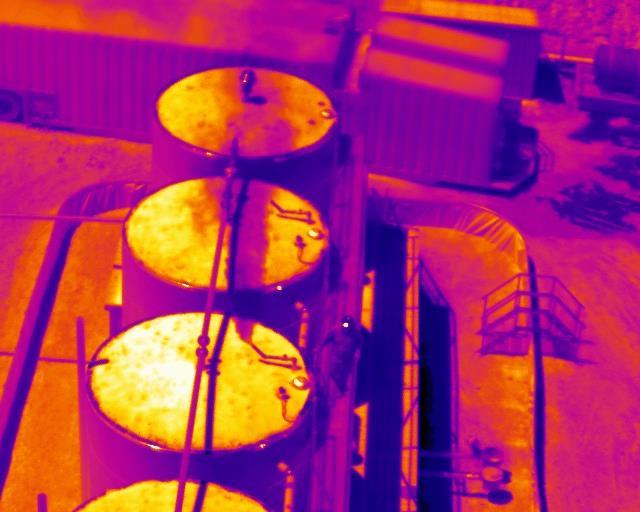
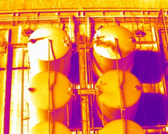
12 Capabilities Fluid Detection with IR Able to detect 70 produced water leak detected at ½ GPM in <45 environment Temperature differentials shown through color gradient DJI Matrice 600 Pro


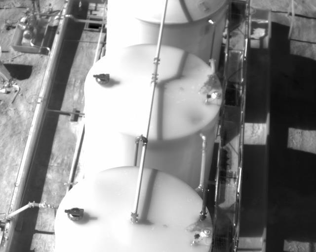
13 Capabilities Autonomous Pipeline Inspection Operation controlled by GPS coordinate driven flight plans High Resolution Footage 1 CMOS Sensor 4k video 20MP photography DJI Phantom 4 Pro


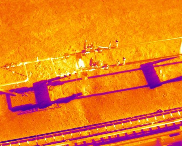
14 Capabilities Autonomous Pipeline Inspection Leak shown in red below Leak from in between two eastern most tanks DJI Phantom 4 Pro Imagery generated from 4k HD video
15 Capabilities Autonomous Pipeline Inspection Plan section out the field Build large scale GPS coordinates flight plan Designate multiple efficient battery replace & recharge locations Capture baseline data section by section Compile data and stitch results for seamless path viewing Analyze data path by path Create database of captured information Use this database to create baseline & compare future datasets Flag problem areas Generate work orders for follow up
")
16 Capabilities- Aerial Facility Inspection Pre-program flights with 3D flight plan Create baseline footage of oil and gas facilities Store footage in database Sensor Selection: Visual Provides visual irregularity detection and baseline reference OGI Detect and locate source of methane gas leaks Thermal Displays temperature differential revealing hot/cold areas RMLD (Remote Methane Leak Detection) Monitor, locate, and quantify volumetric leak rates of methane Moisture Highlights relative humidity levels in various soils

17 Capabilities- Automated 3D Mapping Use of high resolution digital cameras and orthophotography for production of 2D & 3D models Orthomosaic and Point Cloud Models Reduced time on-site for data collection Collection occurs away hazardous components Rapid deliverable turn-around time


18 Capabilities- Automated 3D Mapping Orthomosaic image an aerial photograph geometrically corrected such that the scale is uniform the photo has the same lack of distortion as a map can be used to measure true distances, having been adjusted for topographic relief, lens distortion, and camera tilt Original 2D Aerial Imagery Orthomosaic


19 Capabilities- Automated 3D Mapping 3D Point Cloud Model For use in engineering drawings plot plan creation, mechanical piping model, TVCS calculations, brown field development, accurate measurement Translational tool to communicate between field operations and corporate engineering Transactional exhibit representing physical reality at given point in time 20 [ft]


20 Data Storage Platform Online portal allowing for easily sharable data Visual and OGI capable Report generating


21 Conclusion 1. Autonomous Pipeline Inspection Finding a needle in a haystack 2. Aerial Facility Inspection Decreasing profit loss while increasing safety 3. Automated 3D Mapping Building model as-built isometric drawings 4. Data Storage Platform Centralized data storage and information communication Concentration of Technology 3 4 sensors on single aircraft Single flight path
22 Agility. Innovation. Collaboration Denver Location: 7936 E. Arapahoe Ct., Suite 3200 Centennial, CO JAN2018.
Equipment. Remote Systems & Sensors. Altitude Imaging uses professional drones and sensors operated by highly skilled remote pilots
 Remote Systems & Sensors Altitude Imaging uses professional drones and sensors operated by highly skilled remote pilots Equipment www.altitude-imaging.com About Us Altitude Imaging has been providing a
The Use and Applications of Unmanned- Aerial Systems (UAS) In Agriculture
 In Agriculture") The Use and Applications of Unmanned- Aerial Systems (UAS) In Agriculture R O B E R T A U S T I N, D E P A R T M E N T O F S O I L S C I E N C E N C S T A T E U N I V E R S I T Y DJI Inspire Photo Credit:
The Use and Applications of Unmanned- Aerial Systems (UAS) In Agriculture R O B E R T A U S T I N, D E P A R T M E N T O F S O I L S C I E N C E N C S T A T E U N I V E R S I T Y DJI Inspire Photo Credit:
Virtual and remote inspection methods
 Virtual and remote inspection methods Rasmus Lindeneg Johansen, RLJ@cowi.dk 1 How do we inspect "today"? 2 Inspection "today" Manual inspections From the ground From lift/platform By rope Data was collected
UAV Geophysics Workshop
 UAV Geophysics Workshop September 29, 2017 www.denbury.com NYSE: DNR 1 Mapping Oilfield Infrastructure with UAV Application of high resolution photogrammetry to seismic survey planning and reclamation
Security and Disaster Preparedness: New York s Experience. Presented by: New York Department of Public Service. December 7, James T.
 Security and Disaster Preparedness: New York s Experience Presented by: James T. Gallagher New York Department of Public Service james_gallagher@dps.state.ny.us December 7, 2001 Rome, Italy 1 Security
Remote Control Thermal Imaging Camera System - 12V - Wireless or Wired Remote - 6" LCD Monitor
 Remote Control Thermal Imaging Camera System - 12V - Wireless or Wired Remote - 6" LCD Monitor Part #: RCL-336 The Golight remote controlled thermal imaging infrared camera system with 6 inch LCD monitor
2/9/2016. Session Agenda: Implementing new Geospatial Technologies for more efficient data capture
 Implementing new Geospatial Technologies for more efficient data capture Jay Haskamp Applied Geospatial Engineer Steve Richter VP Sales Session Agenda: Today s changing technologies and what lies ahead
INTRODUCTION TO Accelerating Data Collection with Unmanned Aircraft Systems
 INTRODUCTION TO Accelerating Data Collection with Unmanned Aircraft Systems Kyle Kukuk Terry Pallotto MWCC Enviromental Conference July 10-12, 2016 Who is Here? Kyle Kukuk, PE Project Manager Blackstone
The Ups, Downs and All- Arounds of an IR Camera
 February 2016 The Ups, Downs and All- Arounds of an IR Camera Tim Crockett LDAR First Line Supervisor Baton Rouge Complex Agenda Introduction IR Camera Uses and Features IR Camera Safety Tips IR Camera
UAV Surveying II. Precision. Accuracy. Reliability
 UAV Surveying II Precision. Accuracy. Reliability Part One: Project Lifecycle Deliverables Part Two: Evaluation of UAV Data Accuracy and Examples of Error Part Three: AGENDA Review of Results Examples
THE GLOBAL LEADER IN INFRARED CAMERAS BEYOND COMPARE. FLIR B-Series. Smart, compact and powerful
 THE GLOBAL LEADER IN INFRARED CAMERAS T R U L Y BEYOND COMPARE FLIR B-Series Smart, compact and powerful B-Series THE GLOBAL LEADER IN INFRARED CAMERAS B200 An upgradable range of smart, compact and powerful
FOUR-BAND THERMAL MOSAICKING: A NEW METHOD TO PROCESS THERMAL IMAGERY FROM UAV FLIGHT YICHEN YANG YALE SCHOOL OF FORESTRY AND ENVIRONMENTAL STUDIES
 FOUR-BAND THERMAL MOSAICKING: A NEW METHOD TO PROCESS THERMAL IMAGERY FROM UAV FLIGHT YICHEN YANG YALE SCHOOL OF FORESTRY AND ENVIRONMENTAL STUDIES OUTLINE Background Objectives Methodology Results Calibration
DRONE MOUNTED NATURAL GAS PIPELINE LEAK DETECTION AND ASSET SAFETY MONITORING
 DRONE MOUNTED NATURAL GAS PIPELINE LEAK DETECTION AND ASSET SAFETY MONITORING KEY WORDS: Asset monitoring, Safety checks, performance analysis, Mid IR range, Laser based Methane detection, unmanned aerial
USING UNMANNED AERIAL VEHICLE (DRONE/FLYCAM) TECHNOLOGY IN SURVEY WORK OF PORTCOAST
 TECHNOLOGY IN SURVEY WORK OF PORTCOAST") USING UNMANNED AERIAL VEHICLE (DRONE/FLYCAM) TECHNOLOGY IN SURVEY WORK OF PORTCOAST 1. Capturing aerial images by using Drone Taking images by drones is currently applied in many fields especially in topographic
USING UNMANNED AERIAL VEHICLE (DRONE/FLYCAM) TECHNOLOGY IN SURVEY WORK OF PORTCOAST 1. Capturing aerial images by using Drone Taking images by drones is currently applied in many fields especially in topographic
Payloads. Which one(s) are right for your organization?
 are right for your organization?") Payloads Which one(s) are right for your organization? What is a payload anyway? Not as simple as it may sound and critically important. Integrated and fixed? Interchangeable? Field changeable? Impact
Payloads Which one(s) are right for your organization? What is a payload anyway? Not as simple as it may sound and critically important. Integrated and fixed? Interchangeable? Field changeable? Impact
Aerial Mapping using UAS. Jeff Campbell
 Aerial Mapping using UAS Jeff Campbell 1 Agenda 1. Introduction 2. UAS Mapping Explained 3. Use Cases / Outputs 4. Technologies 5. Training Methods 6. Implementation Strategies 7. Emerging Technologies
Overview of the Trimble TX5 Laser Scanner
 Overview of the Trimble TX5 Laser Scanner Trimble TX5 Revolutionary and versatile scanning solution Compact / Lightweight Efficient Economical Ease of Use Small and Compact Smallest and most compact 3D
Drone2Map: an Introduction. October 2017
 Drone2Map: an Introduction October 2017 Drone2Map: An Introduction Topics: - Introduction to Drone Mapping - Coordinate Systems - Overview of Drone2Map - Basic Drone2Map Workflow - 2D Data Processing -
UAS Campus Survey Project
 ARTICLE STUDENTS CAPTURING SPATIAL INFORMATION NEEDS UAS Campus Survey Project Texas A&M University- Corpus Christi, home to the largest geomatics undergraduate programme in Texas, USA, is currently undergoing
Assessing the Accuracy of Stockpile Volumes Obtained Through Aerial Surveying
 CASE STUDY Assessing the Accuracy of Stockpile Volumes Obtained Through Aerial Surveying Martin Remote Sensing share surveying insight DroneDeploy Introduction This report comes to us from Kelsey Martin,
3D Industrial plants. Documentation
 3D Industrial plants Documentation Published by: FARO Europe GmbH & Co. KG, Lingwiesenstrasse 11/2, D-70825 Korntal-Münchingen, Tel: +49 7150 9797-0, Fax: +49 7150 9797-44, info@faroeurope.com, www.faro.com
UKRSPECSYSTEMS is a Ukrainian based company focused in developing and producing UAV platforms, camera payloads and related equipment.
 1 UKRSPECSYSTEMS is a Ukrainian based company focused in developing and producing UAV platforms, camera payloads and related equipment. Our Gyro-Stabilized Gimbals 2 Meet our product line of gyro-stabilized
Reality Modeling Drone Capture Guide
 Reality Modeling Drone Capture Guide Discover the best practices for photo acquisition-leveraging drones to create 3D reality models with ContextCapture, Bentley s reality modeling software. Learn the
Photogrammetry: A Modern Tool for Crash Scene Mapping
 Photogrammetry: A Modern Tool for Crash Scene Mapping Background A police accident investigator (AI) has many tasks when arriving at a crash scene. The officer s highest priority is public safety; the
Trimble UAS Portfolio Update. August 25 th 2015
 Trimble UAS Portfolio Update August 25 th 2015 Trimble UAS Portfolio Updates Trimble UX5 Setting the Standard in Mapping Trimble UX5 HP High Precision Surveying and Mapping Solution Trimble ZX5 Flexible
REASONS. to choose a Fluke Infrared Camera
 REASONS to choose a Fluke Infrared Camera 1Superior image quality Fluke maximizes the performance of every pixel throughout our entire infrared camera portfolio with detector resolutions ranging from 1024x768
UAS to GIS Utilizing a low-cost Unmanned Aerial System (UAS) for Coastal Erosion Monitoring
 for Coastal Erosion Monitoring") UAS to GIS Utilizing a low-cost Unmanned Aerial System (UAS) for Coastal Erosion Monitoring A New Window on the World Personal Mapping for Micro-Geographies Accurate High Quality Simple Low-Cost Drone2Map
UAS to GIS Utilizing a low-cost Unmanned Aerial System (UAS) for Coastal Erosion Monitoring A New Window on the World Personal Mapping for Micro-Geographies Accurate High Quality Simple Low-Cost Drone2Map
STARTING WITH DRONES. Data Collection and Remote Sensing with UAVs, etc. Dr. Bill Hazelton LS
 STARTING WITH DRONES Data Collection and Remote Sensing with UAVs, etc. Dr. Bill Hazelton LS What this Talk is About UAV-based data acquisition: What you need to get involved Processes in getting spatial
Fluke Ti Series Thermal Imagers. Predict impending failures faster by seeing more
 Fluke Ti Series Thermal Imagers Predict impending failures faster by seeing more Fluke IR FlexCam Thermal Imagers The thermal imagers for professionals demanding the best The Fluke IR FlexCams produce
DRONE MAPPING FOR CONSTRUCTION
 DRONE MAPPING FOR CONSTRUCTION POWERFUL SOLUTIONS FOR AS-BUILT SURVEYS AND SITE DOCUMENTATION - AUTOMATED FLEXIBLE PROCESSING - REPEATABLE RELIABLE ACCURACY - APPLICABLE RESULTS WE CAPTURE IMAGES FROM
Leica Geosystems UAS Airborne Sensors. MAPPS Summer Conference July 2014 Alistair Stuart
 Leica Geosystems UAS Airborne Sensors MAPPS Summer Conference July 2014 Alistair Stuart 1 Sensors for UAS! Promise of UAS is to expand aerial data acquisition capabilities for traditional and non-traditional
Reasons. to choose a Fluke Infrared Camera
 Reasons to choose a Fluke Infrared Camera 1Superior image quality Fluke maximizes the performance of every pixel throughout our entire infrared camera portfolio with detector resolutions ranging from 1024x768
Technical Data FLIR i7
 Technical Data FLIR i7 Part number: 39301-0305 Copyright Names and marks appearing herein are either registered trademarks or trademarks of FLIR Systems and/or its subsidiaries. All other trademarks, trade
Jeffrey A. Schepers P.S. EIT Geospatial Services Holland Engineering Inc. 220 Hoover Blvd, Suite 2, Holland, MI Desk
 Jeffrey A. Schepers P.S. EIT Geospatial Services Holland Engineering Inc. 220 Hoover Blvd, Suite 2, Holland, MI 49423 616-594-5127 Desk 616-322-1724 Cell 616-392-5938 Office Mobile LiDAR - Laser Scanning
TRUSTED WORLDWIDE SINCE 1908 DRONES EQUIPMENT PAYLOADS FAA NEEDS TRAINING SUPPORT
 TRUSTED WORLDWIDE SINCE 1908 DRONES EQUIPMENT PAYLOADS FAA NEEDS TRAINING SUPPORT DARLEY SINCE 1908, W.S DARLEY & COMPANY HAS BEEN DEVOTED TO SERVING THE WORLD S FIRST RESPONDERS AND WARFIGHTERS. WE ARE
Unmanned Aerial Systems: A Look Into UAS at ODOT
 Ohio Department of Transportation John R. Kasich, Governor Jerry Wray, Director Unmanned Aerial Systems: Tim Burkholder, PS Mapping Manager Division of Engineering Office of CADD and Mapping Services Kyle
Datasheet. Revision number: 2.1
 Datasheet Revision number: 2.1 Workswell WIRIS 2nd Generation Introduction Workswell s.r.o. is pleased to introduce you a brand new thermal imaging system Workswell WIRIS 2 nd Generation for unmanned air
Presentation Outline. Preserving the Evidence: Multi-Platform 3D Reality Captures for Tornado Damage. Objectives. Learning from Tornado Damage
 Presentation Outline Preserving the Evidence: Multi-Platform 3D Reality Captures for Tornado Damage J. ArnWomble, Ph.D., P.E. Assistant Professor of Civil Engineering West Texas A&M University Canyon/Amarillo,
Phase One Industrial Fully Integrated Drone Solution
 Phase One Industrial Fully Integrated Drone Solution Fully Integrated Drone Solution The use of drones and UAV-based platforms in the aerial imaging market is increasing rapidly, and remote sensing is
Practical Considerations of UAS Operations on Data Quality
 Practical Considerations of UAS Operations on Data Quality Precision. Accuracy. Reliability OVERVIEW Project Planning and Execution Ground Control Data Processing and Delivery 1 OVERVIEW Get Legal: Section
Phase One Industrial Fully Integrated Drone Solution
 Phase One Industrial Fully Integrated Drone Solution Fully Integrated Drone Solution The use of drones and UAV-based platforms in the aerial imaging market is increasing rapidly, and remote sensing is
Hydra Fusion Tools. Capabilities Guide. Real-time 3D Reconstructions
 Hydra Fusion Tools Capabilities Guide Real-time 3D Reconstructions Hydra Fusion Tools Building a Mapping System Flying an unmanned aircraft system (UAS) is no longer a stand-alone activity. Operators are
Zenmuse XT Release Notes
 2017.06.28 1. Firmware Version: v1.30.0.10 2. DJI Pilot App Android Version: v0.3.1 Added support for the Matrice 200. 1. This firmware upgrade is for the Zenmuse XT gimbal and camera only. It cannot be
TopoDrone Photogrammetric Mapping Reliable, Accurate, Safe
 TopoDrone Photogrammetric Mapping Reliable, Accurate, Safe A complete solution for accurate airborne data capture and photogrammetric mapping using an unmanned aerial vehicle COST EFFICIENT SOLUTION TO
HYDRA FUSION TOOLS CAPABILITIES GUIDE REAL-TIME 3D RECONSTRUCTIONS
 HYDRA FUSION TOOLS CAPABILITIES GUIDE REAL-TIME 3D RECONSTRUCTIONS HYDRA FUSION TOOLS BUILDING A MAPPING SYSTEM Flying an unmanned aircraft system (UAS) is no longer a stand-alone activity. Operators are
Trimble Business Center Software, v3.30
 Trimble Business Center Software, v3.30 We are pleased to announce a new version of the Trimble Business Center software, version 3.30. This new version includes over 30 new features and enhancements increasing
3.1 MP Thermal Infrared Imaging Camera - Laser Spot, GPS, Bluetooth, Wi-Fi Hrs Runtime
 3.1 MP Thermal Infrared Imaging Camera - Laser Spot, GPS, Bluetooth, Wi-Fi - 2.5 Hrs Runtime Part #: TMRCMR-PCM-3.1MP Page: 1 The TMRCMR-PCM-3.1MP Thermal Infrared Imaging Camera is a robust temperature-monitoring
Over the years, they have been used several tools to perform aerial surveys of analyzed to archaeological sites and monuments. From the plane to the
 Over the years, they have been used several tools to perform aerial surveys of analyzed to archaeological sites and monuments. From the plane to the balloon, the balloon to the telescopic rods, all of
Trimble VISION Positions from Pictures
 Trimble VISION Positions from Pictures This session will cover What Is Trimble VISION? Trimble VISION Portfolio What Do you Need? How Does It Work & How Accurate Is It? Applications Resources Trimble VISION
Harnessing GIS and Imagery for Power Transmission Inspection. ESRI European Users Conference October 15, 2015
 Harnessing GIS and Imagery for Power Transmission Inspection ESRI European Users Conference October 15, 2015 About Us Airborne/Threod Designer, manufacturer & service provider for multi-rotor & fixed wing
Trimble GeoSpatial Products
 Expanding Solutions for Photogrammetric and Remote Sensing Professionals 55 th Photogrammetric Week in Stuttgart September 7 th 2015 Tobias Heuchel, Trimble Stuttgart, Germany Trimble GeoSpatial Products
PREMIUM PROPERTY MARKETING
 PREMIUM PROPERTY MARKETING 01789 722 500 contact@mcs-media.com www.mcs-media.com WHAT WE DO Aerial Drone videos Ground based videos Architectural photography 3D Walkthroughs Single property websites Professional
Generating highly accurate 3D data using a sensefly exom drone
 Generating highly accurate 3D data using a sensefly exom drone C. Álvarez 1, A. Roze 2, A. Halter 3, L. Garcia 4 1 Geomatic Engineer, Lehmann Géomètre SA 2 Application Engineer, sensefly SA 3 Geomatic
Open Pit Mines. Terrestrial LiDAR and UAV Aerial Triangulation for. Figure 1: ILRIS at work
 Terrestrial LiDAR and UAV Aerial Triangulation for Open Pit Mines Figure 1: ILRIS at work Figure 2: Geo-Copter X-8000 taking off ay what you will about the past few years, it has produced some useful tools
Challenges and Trends on Microbolometer Design. Uwe Pulsfort Product & Applications Support, Europe
 Challenges and Trends on Microbolometer Design Uwe Pulsfort Product & Applications Support, Europe Overview 1. Evolution of the Markets 2. Example Applications 3. Key Drivers for Low Cost Uncooled IR 4.
Case Study for Long- Range Beyond Visual Line of Sight Project. March 15, 2018 RMEL Transmission and Planning Conference
 Case Study for Long- Range Beyond Visual Line of Sight Project March 15, 2018 RMEL Transmission and Planning Conference 2014 HDR Architecture, 2016 2014 HDR, Inc., all all rights reserved. Helicopters
WIRELESS CCTV. Rapid Deployment Video.
 WIRELESS CCTV Rapid Deployment Video Wireless CCTV Wireless CCTV (WCCTV) is a market leading, customer focused provider of portable, redeployable surveillance solutions. WCCTV manufactures and delivers
Project: UAV Payload Retract Mechanism. Company Background. Introduction
 Ascent Vision Technologies LLC 90 Aviation Lane Belgrade, MT 59714 Tel 406.388.2092 Fax 406.388.8133 www.ascentvision.com Project: UAV Payload Retract Mechanism Company Background Ascent Vision Technologies
Real world data collecting tools. Company Introduction. C2L equipment.co,.ltd
 Company Introduction C2L equipment.co,.ltd www.c2l-equipment.com Company Status Business Areas Company name C2L equipment.co,.ltd Address CEO Unit 603, Samwhan HIPEX B, Pangyo Station RD 230, Bundang,
FLIR T Imaging and optical data. Minimum focus distance. Minimum focus distance with MSX. Spatial resolution (IFOV)
") Copyright All rights reserved worldwide. Names and marks appearing herein are either registered trademarks or trademarks of FLIR Systems and/or its subsidiaries. All other trademarks, trade names or company
Copyright All rights reserved worldwide. Names and marks appearing herein are either registered trademarks or trademarks of FLIR Systems and/or its subsidiaries. All other trademarks, trade names or company
A Data Fusion Platform for Supporting Bridge Deck Condition Monitoring by Merging Aerial and Ground Inspection Imagery
 A Data Fusion Platform for Supporting Bridge Deck Condition Monitoring by Merging Aerial and Ground Inspection Imagery Zhexiong Shang, 1 Chongsheng Cheng, 2 and Zhigang Shen, Ph.D. 3 1 NH 113, Durham School
T1K HD THERMAL IMAGING CAMERA THE ULTIMATE IN INFRARED PERFORMANCE
 T1K HD THERMAL IMAGING CAMERA THE ULTIMATE IN INFRARED PERFORMANCE INTRODUCING THE OUTSTANDING INFRARED PERFORMANCE, BUILT ON 50 YEARS OF EXPERIENCE T1K Born out of five decades of infrared expertise,
IR-Thermal image analysis Fault detection made easy!
 Innovation in Tools IR-Thermal image analysis Fault detection made easy! Locating and analysing effi ciently: The ThermoCamera-Vision and ThermoCamera-Vision XP make it possible. Problem solver in a wide
Commercial suas The Right Tool for the Right Job
 Commercial suas The Right Tool for the Right Job Presentation Objectives Overview of current data collection technologies UAS Systems Overview Surveyor 2.0 Project Case Study Mobile LiDAR & suas How Do
2. POINT CLOUD DATA PROCESSING
 Point Cloud Generation from suas-mounted iphone Imagery: Performance Analysis A. D. Ladai, J. Miller Towill, Inc., 2300 Clayton Road, Suite 1200, Concord, CA 94520-2176, USA - (andras.ladai, jeffrey.miller)@towill.com
An Overview of Mobile GIS Apps for Field Data Collection. Matt Alexander Anatum Field Solutions, LLC
 An Overview of Mobile GIS Apps for Field Data Collection Matt Alexander Anatum Field Solutions, LLC 2010 ios GIS Apps No accurate GPS/GNSS (TestedniPhone 6 and ipad Air = 6.5m [95% CI]) New Tech Opens
PhotoScan. Fully automated professional photogrammetric kit
 PhotoScan Fully automated professional photogrammetric kit Agisoft PhotoScan is a stand-alone photogrammetric software solution for automatic generation of dense point clouds, textured polygonal models,
The intelligent mapping & inspection drone
 The intelligent mapping & inspection drone 3 reasons to choose exom 1 flight, 3 types of imagery With exom you can switch between capturing video, still and thermal imagery during the same flight, without
trimble unmanned aircraft systems
 trimble unmanned aircraft systems FOR SURVEYING and MAPPING TRIMBLE UAS AERIAL IMAGING solution: INDUSTRY-LEADING UAS MAPPING SOLUTIONS FOR ALL YOUR APPLICATION NEEDS Trimble prides itself on being a leader
A New Protocol of CSI For The Royal Canadian Mounted Police
 A New Protocol of CSI For The Royal Canadian Mounted Police I. Introduction The Royal Canadian Mounted Police started using Unmanned Aerial Vehicles to help them with their work on collision and crime
INFRARED CAMERAS THT
 D I G I T A L INFRARED CAMERAS 70 60 Simply everything. Light capacitive Touch Screen Optical Interchangeable* Lenses Laser Pointer* Visual image camera* Built-in Flash LED* 384x288 160x120 p i x e l Up
T-SERIES UNLEASH THE ULTIMATE POWER OF FLIR. thermal IMAGING CAMERAS FoR PREDICtIVE MAINtENANCE
 T-SERIES thermal IMAGING CAMERAS FoR PREDICtIVE MAINtENANCE UNLEASH THE ULTIMATE POWER OF FLIR T-SERIES the ultimate thermal IMAGER PRoDuCtIVItY boost Touchscreen tools as intuitive as a smartphone s Simple
UAS for Surveyors. An emerging technology for the Geospatial Industry. Ian Murgatroyd : Technical Sales Rep. Trimble
 UAS for Surveyors An emerging technology for the Geospatial Industry Ian Murgatroyd : Technical Sales Rep. Trimble Project Overview Voyager Quarry, located near Perth Australia Typical of hard rock mines,
The MK Proven technology, redefined (0) MikroKopter.de
 MikroKopter.de") The MK8-3500 Proven technology, redefined 10 years MikroKopter HiSystems GmbH Flachsmeerstr. 2 26802 Moormerland www. contact@hisystems.de 0049 (0) 4954 8932 520 Compact, robust and clever designed: The
The MK8-3500 Proven technology, redefined 10 years MikroKopter HiSystems GmbH Flachsmeerstr. 2 26802 Moormerland www. contact@hisystems.de 0049 (0) 4954 8932 520 Compact, robust and clever designed: The
Zenmuse XT Release Notes
 2018.03.30 1. Firmware Version: v1.31.0.00 2. DJI Pilot App Android Version: v0.5.1 3. DJI GO App ios Version: V3.1.30 4. DJI GO App Android Version: V3.1.28 1. Fixed an issue where users can't take photos
ЗАО «БЕРГ АБ», (495) , Thermal cameras. Detect hot spots before they cause trouble
 , Thermal cameras. Detect hot spots before they cause trouble") Thermal cameras Detect hot spots before they cause trouble Thermal imaging Detect hot spots before they cause trouble Since the dawn of the industrial age, temperature has been used to give an indication
Thermal cameras Detect hot spots before they cause trouble Thermal imaging Detect hot spots before they cause trouble Since the dawn of the industrial age, temperature has been used to give an indication
Accuracy Assessment of an ebee UAS Survey
 Accuracy Assessment of an ebee UAS Survey McCain McMurray, Remote Sensing Specialist mmcmurray@newfields.com July 2014 Accuracy Assessment of an ebee UAS Survey McCain McMurray Abstract The ebee unmanned
Fluke TiR Series Thermal Imagers
 Fluke TiR Series Thermal Imagers Find building problems faster. IR-Fusion Technology infrared and visual images fused together makes infrared easy to understand Designed especially for building and restoration
Quality Accuracy Professionalism
 GeoWing - who are we? Mapping Data Service Provider Lidar Multispectral Topographic and Planimetric Maps Elevation Models Point Clouds / 3D Models Orthophotography FAA-Authorized UAS Operators WOSB / DBE
See more with the NEW testo 880 thermal imager
 Committing to the future See more with the NEW testo 880 thermal imager NEW! SEE MORE......OFFER MORE. Infrared radiation cannot be seen by the human eye. All objects whose temperature is above absolute
GPS-Aided Inertial Navigation Systems (INS) for Remote Sensing
 for Remote Sensing") GPS-Aided Inertial Navigation Systems (INS) for Remote Sensing www.inertiallabs.com 1 EVOLUTION OF REMOTE SENSING The latest progress in Remote sensing emerged more than 150 years ago, as balloonists took
GPS-Aided Inertial Navigation Systems (INS) for Remote Sensing www.inertiallabs.com 1 EVOLUTION OF REMOTE SENSING The latest progress in Remote sensing emerged more than 150 years ago, as balloonists took
SimActive and PhaseOne Workflow case study. By François Riendeau and Dr. Yuri Raizman Revision 1.0
 SimActive and PhaseOne Workflow case study By François Riendeau and Dr. Yuri Raizman Revision 1.0 Contents 1. Introduction... 2 1.1. Simactive... 2 1.2. PhaseOne Industrial... 2 2. Testing Procedure...
UAV Flight Operations for Mapping. Precision. Accuracy. Reliability
 UAV Flight Operations for Mapping Precision. Accuracy. Reliability Part One: Why is Mapping different? Part Two: What about accuracy and precision? Part Three: What is the Workflow? Part Four: AGENDA What
Digital Photogrammetry Software Comparison for Rock Mass Characterization
 ARMA 18 1211 Digital Photogrammetry Software Comparison for Rock Mass Characterization Becker, R.E., Galayda, L.J., MacLaughlin, M.M. Montana Tech, Butte, Montana, USA Copyright 2018 ARMA, American Rock
USER MANUAL TOUGHPIX DIGITHERM. RUGGED AUTHORITY
 USER MANUAL TOUGHPIX DIGITHERM RUGGED AUTHORITY www.cord-ex.com Congratulations - You are the owner of a TOUGHPIX DIGITHERM CAMERA. A compact pocket sized digital imaging camera capable of capturing true
Trends in Digital Aerial Acquisition Systems
 Trends in Digital Aerial Acquisition Systems Ernest Yap Regional Sales Manager, Airborne-Americas eyap@applanix.com 1 Medium Format Digital Cameras Medium Format Digital Cameras Where does the Medium
New demand, new markets: What edge computing means for hardware companies
 New demand, new markets: What edge computing means for hardware companies With over 100 edge use cases identified, the fast-growing need to power connected devices demands a custom response from vendors.
(Subsea) Keith Vickery Zupt LLC
 Keith Vickery Zupt LLC") (Subsea) Keith Vickery Zupt LLC kv@zupt.com Offshore subsea infrastructure surveys (pipeline inspection, well, XT, and manifold inspections) are required to ensure compliance with both internal operator,
(Subsea) Keith Vickery Zupt LLC kv@zupt.com Offshore subsea infrastructure surveys (pipeline inspection, well, XT, and manifold inspections) are required to ensure compliance with both internal operator,
T-SERIES THERMAL IMAGING CAMERAS FOR PREDICTIVE MAINTENANCE UNLEASH THE ULTIMATE POWER OF FLIR
 T-SERIES THERMAL IMAGING CAMERAS FOR PREDICTIVE MAINTENANCE UNLEASH THE ULTIMATE POWER OF FLIR T-SERIES THE ULTIMATE THERMAL IMAGER PRODUCTIVITY BOOST Touchscreen tools as intuitive as a smartphone s Simple
PhotoScan. Fully automated professional photogrammetric kit
 PhotoScan Fully automated professional photogrammetric kit Agisoft PhotoScan is a stand-alone photogrammetric software solution for automatic generation of dense point clouds, textured polygonal models,
Global Tracking. Personal Tracker and Messenger Connect with Your Workers Anywhere in the World
 Global Tracking Personal Tracker and Messenger Connect with Your Workers Anywhere in the World Connect With Your Workers Anywhere in the World. When the safety of your personnel is at stake especially
NEW INNOVATIVE TECHNOLOGY THAT WILL GROW YOUR BUSINESS. Wohler VIS 700 HD-Video Inspection System. High definition images for reliable results
 NEW INNOVATIVE TECHNOLOGY THAT WILL GROW YOUR BUSINESS Wohler VIS 700 HD-Video Inspection System High definition images for reliable results The Measure of Technology Made in Germany HD TOUCH- SCREEN Wohler
DJI Phantom 3 - Standard Edition + Softshell Backpack
 DJI Phantom 3 - Standard Edition + Softshell Backpack SAVE21% Drone Capabilities Included 2.7K / 12 Megapixel Camera Integrated 3-Axis Stabilization Gimbal Easy to Fly, Intelligent Flight System Live HD
REASONS. to choose a Fluke Thermal Imager
 REASONS to choose a Fluke Thermal Imager 1Superior image quality Fluke maximizes the performance of every pixel throughout our entire thermal imager portfolio with detector resolutions ranging from 320x240
Forest Planning with UAVs and other Emerging Technologies. Jonathan Lok, RFT
 Forest Planning with UAVs and other Emerging Technologies Jonathan Lok, RFT Core Concepts of Planning Plan the Work Work the Plan Qualified professionals Best available data Applied knowledge and experience
SLR, Climate Change, Infrastructure Solutions, Adaption and GIS
 Presenters: Francisco D Elia B.S., M.Sc. Geographic Information Systems Franciscodelia@miamibeachfl.gov Nestor Navarro, GISP, MCSA GIS Manager Nestornavarro@miamibeachfl.gov Data Acquisition, Integration
Intelligent photogrammetry. Agisoft
 Intelligent photogrammetry Agisoft Agisoft Metashape is a cutting edge software solution, with its engine core driving photogrammetry to its ultimate limits, while the whole system is designed to deliver
T-SERIES UNLEASH THE ULTIMATE POWER OF FLIR THERMAL IMAGING CAMERAS FOR PREDICTIVE MAINTENANCE
 99 Washington Street Melrose, MA 02176 Phone 781-665-1400 Toll Free 1-800-517-8431 Visit us at www.testequipmentdepot.com T-SERIES THERMAL IMAGING CAMERAS FOR PREDICTIVE MAINTENANCE UNLEASH THE ULTIMATE
Infrared Thermometer User Manual
 Infrared Thermometer User Manual Contents 1. Introduction... 2 2. Features... 2 3. Application... 2 4. Safety...3 5. Field of View...4 6. Specifications... 5 7. Meter Description...6 8. LCD Display Description...6
UAV s in Surveying: Integration/processes/deliverables A-Z. 3Dsurvey.si
 UAV s in Surveying: Integration/processes/deliverables A-Z Info@eGPS.net TODAY S PROGRAM Introduction to photogrammetry and 3Dsurvey Theoretical facts about the technology and basics of 3dsurvey Introduction