An Overview of Mobile GIS Apps for Field Data Collection. Matt Alexander Anatum Field Solutions, LLC
|
|
|
- Austen Newman
- 6 years ago
- Views:
Transcription
1 An Overview of Mobile GIS Apps for Field Data Collection Matt Alexander Anatum Field Solutions, LLC


2 2010 ios GIS Apps No accurate GPS/GNSS (TestedniPhone 6 and ipad Air = 6.5m [95% CI])


3 New Tech Opens New Doors 2012-ish BlueTooth External 2.5-meter GPS Bad Elf Pro GPS (Tested 2.2m at 95% CI) Garmin Glo Dual XGPS150


 60 meter Trimble")
4 Submeter GNSS Finally Arrives! isxblue II GNSS (2013) Accuracy 0.60 meter Arrow 100 GNSS (2014) Accuracy 0.60 meter Trimble R1 (2015) Accuracy < 1.0 meter
 Accuracy 1 cm")
 Accuracy 1 cm")
5 RTK Market Grows SXBlue III GNSS (2014) Accuracy 1 cm Arrow 200 GNSS (2014) Accuracy 1 cm CHC X91+ GNSS (2015) Accuracy 1 cm
 Real-time access to GIS server Internet")
6 Full Hardware Solution ipad (or equivalent tablet) Waterproof case Strap system Apps Aplenty! Mobile GIS Plant Guides Compass/Camera PDF Reader External battery Cellular service (optional) Real-time access to GIS server Internet access GNSS 2.5 meter GPS Submeter GNSS RTK


7 Workflow Tablet paired to GNSS Monitor GNSS health Mobile GIS App for data collection and export Cloud server
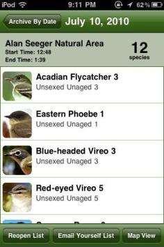
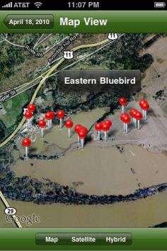
8 Successful Experiences Projects Types of Surveys Wetland Delineations Habitat Mapping T&E Species Surveys Aerial Raptor Nest Post-con Habitat Restoration Monitoring (3 years)
 6. Long-term Asset Monitoring 7.")
9 ipad Benefits TIME AND MONEY SAVINGS 1. Better Navigation 2. Helpful Aerial Imagery 3. Quicker Data Entry 4. Direct Photo Integration 5. Real Time Data Access (Cloud) 6. Long-term Asset Monitoring 7. Better Security (Passcode Lock)

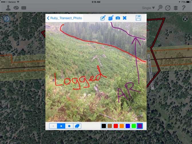
10 ipad Benefits Numbers based on general environmental field surveys in remote areas ipad and Bluetooth GPS startup times save 6% of your work day lost to other GPS technology glitches ipad provides easier field navigation that saves teams 5% of their work day Recording photos and corresponding GPS points is 37% faster than other methods Nightly data upload to the cloud database is 30 times f aster than other methods

11 The Difficult Part Software Multitude of Mobile GIS Apps igeotrak Collector Fulcrum GIS Pro Wolf GIS icmtgis Theodolite GeoJot+ TerraGo Mapistry Geospago Avenza PDF Maps

12 Theodolite HD

13 GeoJot+ Good Photolog Software Photos automatically linked to GPS point and compass bearing Eliminates manual photo loading Saves on expensive office data entry time

14 GeoJot+ Multiple formatting options PDF Word Export KMZ with photos and attribute data attached
 Multiple")

15 Fulcrum Simple back end (HTML) Multiple export options Shapefile CSV KMZ GeoJSON
16 Fulcrum Default report PDF export Export reports customizable

17 Mapistry Web browser based system for data collection Customizable legend and title box for simple map creation

18 TerraGo Edge Custom offline maps Create Task Orders WMS feeds Record audio

19 Avenza PDF Maps Buy GeoPDF s of USGS, USFS, and aerial maps Create simple attribute collection forms Pay for business


20 igeotrak Best mapping system: zoom ANYWHERE & offline image caching Direct integration of aerial imagery at all times Can upload additional imagery layers NAIP satellite UAV imagery SSURGO soils data USGS National Hydrography Data Points, Lines, Polygons Data syncs only DELTA SQL based system for robust database
21 igeotrak
 Linked data fields Auto calculations Data")
22 igeotrak Customizable data collection forms (simple or complex) Multiple photo capture Draw on photos Sketchpad Save map screenshot to point Dropdown picklists (5,000 species) Linked data fields Auto calculations Data history
23 Post-con Habitat Monitoring Yr1 Old Field Data Management ipad Field Data Management Activity Time Activity Time Photos: Trimble + Camera 24 Photos: ipad 14 Nightly download to laptop 2.5 Nightly synch to cloud database Download new project files to Trimble Synch new files to ipad 0.2 Weekly upload to FTP 1 Synch with cloud database 0.2 GIS data compilation 3 Data automatically compiled 0 Manual photo upload 4 Photos automatically linked to GIS features Total hours per week 31 Total hours per week 14.6 Cost $2x Cost $x 0 Time estimated per team per week for photo centric field work
24 Habitat Monitoring Yr 2: All In 6 Field Teams All teams switched to ipads paired with external GPS and electronic data sheet collection and photos (no paper) Each team completed scheduled tasks 20 30% faster than estimated thanks to: Field ipad External GPS igeotrak utilizing cloud interface Cellular data plan when service was available (mostly offline; very remote areas)

25 Additional Information Visit Field Talk Blog Discussions of Mobile GIS best practices Links to our Mobile GIS publications Interviews with: igeotrak Fulcrum Mapistry Avenza PDF Maps Geospago

26 Publications Increasing the Efficiency of Aerial Surveys By Using Tablets for Project Siting, March 2015 Using the Tablet in the Field: Pipeline Post- Construction Restoration Monitoring Case Study, March 2015
27
28 Handheld GPS vs. Mobile GIS Handheld GNSS ArcPad/Terrasync GPS Correct (needed for post-processing) Internal GNSS System can use Real-Time Differential GPS and/or Post-Processing Mobile GIS: Tablet and External GNSS GNSS Manufacturer specific SDK GIS App System relies on Real-Time Differential GPS
Edge App User Guide V 4.5
 Edge App User Guide V 4.5 Table of Contents Introduction... 4 Trial Version... 4 Logging In... 5 1. Home... 7 2. View Notes... 8 2.1. View Notes List & Tab View... 8 2.2. View Notes Map View... 17 3. View
Forest Technology: Apps, Maps, Phones, and Drones
 Forest Technology: Apps, Maps, Phones, and Drones TFA Annual Meeting 2018 Darian Yawn LandMark Spatial Solutions, LLC Forest Technology Company Sales, Training, Support GIS Consulting, Repairs, Rentals
Collecting Data on your Phone or Tablet. Tyler Gakstatter Resource Supply LLC Lake Oswego, OR
 Collecting Data on your Phone or Tablet Tyler Gakstatter Resource Supply LLC Lake Oswego, OR Who can benefit from using smartphones and tablets? One-man show to large field crews. Create maps and push
Construction Survey GIS. Doug Kotnik, GISP
 Construction Survey GIS Doug Kotnik, GISP Construction Survey GIS Sales Service Rentals Training Support Products & Services Authorized Dealer Trimble, Spectra Precision, Nikon, & Ashtech Authorized Warranty
Using Mobile GIS to Aid Hemlock Woolly Adelgid Control Efforts
 Using Mobile GIS to Aid Hemlock Woolly Adelgid Control Efforts Presented by: Alicia Ihnken IhnkenA@michigan.gov Michigan Department of Natural Resources Parks and Recreation Division Background My role
2017 ESRI International User Conference
 2017 ESRI International User Conference Utilizing Collector for ArcGIS for Military Munitions Investigation Matt Held 1 Introduction Baywest GIS Staff Matt Held - GIS Professional for 18 years - Worked
Avenza Maps. ios Operating System TN/KY WILDLAND Fire Academy
 Avenza Maps ios Operating System 2018 TN/KY WILDLAND Fire Academy Created by: T. Barnes December 2017 1 Table of Contents Getting Started (ios)... 5 Map View and Toolbar... 6 Maps List (ios)... 7 Layers
Collector for ArcGIS Preparing for and Working in a disconnected environment
 Collector for ArcGIS Preparing for and Working in a disconnected environment Peter Nasuti, Dan Moore, Nicholas Davis Topics Covered With demonstrations throughout each step 1) What is Collector? What can
Fen Wetland Toolkit. Web Application User Guide Version 1.0. September 28, Contact:
 Fen Wetland Toolkit Web Application User Guide Version 1.0 September 28, 2016 Contact: fenapp@hdrinc.com 1 Fen Wetland Toolkit Table of Contents Background... 3 Getting Started... 3 Registering... 3 Landing
Trimble VISION Positions from Pictures
 Trimble VISION Positions from Pictures This session will cover What Is Trimble VISION? Trimble VISION Portfolio What Do you Need? How Does It Work & How Accurate Is It? Applications Resources Trimble VISION
Fen Wetland Toolkit. Mobile Application User Guide Version 1.0. September 27, Contact:
 Fen Wetland Toolkit Mobile Application User Guide Version 1.0 September 27, 2016 Contact: fenapp@hdrinc.com Fen Wetland Toolkit HDR Data Collection Web-App Table of Contents Background... 2 Installation
Box Competitive Sheet January 2014
 This document is a comparison of file sharing and collaboration capabilities offered by Soonr Workplace and Box. Narrative is provided when there is no direct comparison between the capabilities or when
Functionality of CarryMap 5.2 application for Android devices
 Data East, LLC Functionality of CarryMap 5.2 application for Android devices Content Overview of buttons located on map window... 3 Creating new object... 3 Adding photo to object... 7 Measuring distance
Using the ESRI Collector App: A User s Manual
 Using the ESRI Collector App: A User s Manual Produced by Jim Groot and Carrie Thomas Edited by Erik Cammeraat, Harry Seijmonsbergen and Thijs de Boer Summer 2017 1 Contents Introduction... 3 Getting Started...
Virtual and remote inspection methods
 Virtual and remote inspection methods Rasmus Lindeneg Johansen, RLJ@cowi.dk 1 How do we inspect "today"? 2 Inspection "today" Manual inspections From the ground From lift/platform By rope Data was collected
The Global Positioning Sytem II 10/13/ /13/2015 GEO327G/386G, UT Austin /13/2015 GEO327G/386G, UT Austin 5-4
 The Global Positioning System II Field Experiments Mexico DGPS Field Campaign Cenotes in Tamaulipas, MX, near Aldama 10/13/2015 GEO327G/386G, UT Austin 5-1 10/13/2015 GEO327G/386G, UT Austin 5-2 Are Cenote
User Guide Android App. Get the most out of the MapItFast app on your Android device with this user guide.
 User Guide Android App Get the most out of the MapItFast app on your Android device with this user guide. Last Updated: January 2017 Disclaimer The use of GPS devices, tablets and smartphones with MapItFast
FltPlan Go FAQ. What operating system is FltPlan Go available for? FltPlan Go is available on ios (ipad/iphone), Android, Windows 10, and Mac.
, Android, Windows 10, and Mac.") What operating system is FltPlan Go available for? FltPlan Go is available on ios (ipad/iphone), Android, Windows 10, and Mac. How much does FltPlan Go cost/how many devices can you download it on? FltPlan
What operating system is FltPlan Go available for? FltPlan Go is available on ios (ipad/iphone), Android, Windows 10, and Mac. How much does FltPlan Go cost/how many devices can you download it on? FltPlan
Trimble Indoor Mobile Mapping Solution
 Kevin Perkins Applanix Corp. NATIONAL SURVEYING, MAPPING & GEOSPATIAL CONFERENCE - MARCH 13-17, 2017 Trimble Indoor Mobile Mapping Solution Why Indoor Mapping? The need: As-built maps/models of indoor
Real time Mobile GIS For Transportation
 Real time Mobile GIS For Transportation MATT VON WAHLDE GEONETICS, INC BOSTON, MA Boston, MA Introduction Matt von Wahlde Chief Operating Officer, Geonetics, Inc. Custom Application Development Services
Dropbox is a free service that lets you bring all your photos, docs, and videos anywhere. This means that any file you save to your Dropbox will
 1 Dropbox is a free service that lets you bring all your photos, docs, and videos anywhere. This means that any file you save to your Dropbox will automatically save to all your computers, phones and even
GPS receiver Trimble Juno 3B
 STARTUP & CONFIGURATION Press the power button for a few seconds Open the windows menu (by selecting on screen or pushing the windows button) Select TerraSync > Professional Edition. The upper pull down
Activity: Exploring GeoPDFs
 Activity: Exploring GeoPDFs A GeoPDF is a map stored in Adobe s Portable Document Format that is geographically referenced to a real world coordinate system. TerraGo Technologies, which is the company
GPS/GIS Activities Summary
 GPS/GIS Activities Summary Group activities Outdoor activities Use of GPS receivers Use of computers Calculations Relevant to robotics Relevant to agriculture 1. Information technologies in agriculture
Field Validation Exercise
 Field Validation Exercise Background: When creating complex GIS databases, it is essential that all or a significant portion of the digitized (or acquired) data should to be validated; this is done with
Evaluation of Data Capture in the Field Using Portable Hand- Held Devices
 November 18, 2014 Chris Wheaton StreamNet Evaluation of Data Capture in the Field Using Portable Hand- Held Devices Survey Results Survey Respondents 52 Total responses, 47 indicated affiliations Responses
UTM Geo Map APP Quick Start (Version 1.2)
") UTM Geo Map APP Quick Start (Version 1.2) Measure Points (Marker) You can measure points of coordinate base on GPS or position on the Maps and save marker into database for unlimited number using Real-time
UTM Geo Map APP Quick Start (Version 1.2) Measure Points (Marker) You can measure points of coordinate base on GPS or position on the Maps and save marker into database for unlimited number using Real-time
Mica Lodge Internet Cheat Sheet
 Mica Lodge Internet Cheat Sheet Internet communications and telephone services are provided through satellite connection at Mica. On arrival at the lodge you will be provided with an internet account which
Feature Comparison Checklist
 Feature Comparison Checklist We invite you to use this checklist to help guide your team in identifying your mobile forms requirements. This checklist also provides an easy way to compare the Formotus
Collector for ArcGIS: What s New. Chris LeSueur & James Tedrick
 Collector for ArcGIS: What s New Chris LeSueur & James Tedrick Outline Product overview Workflows Preparing data for Collector for ArcGIS What s new in Collector for ArcGIS v18.1.0 (Aurora) Advanced topics
KDHE Watershed Management Web Map Editor Standard Operating Procedures (SOP) A. How to get Watershed Assignment? a. View Watershed Status
 A. How to get Watershed Assignment? a. View Watershed Status") KDHE Watershed Management Web Map Editor Standard Operating Procedures (SOP) A. How to get Watershed Assignment? a. View Watershed Status B. How to prepare web map for editing. a. Change visible Layers
KDHE Watershed Management Web Map Editor Standard Operating Procedures (SOP) A. How to get Watershed Assignment? a. View Watershed Status B. How to prepare web map for editing. a. Change visible Layers
The New Act! Premium Know Your Customers. Propel Productivity. Make Insightful Decisions.
 The New Act! Premium Know Your Customers. Propel Productivity. Make Insightful Decisions. Sage ACT! 2013 A multitude of product innovations, feature enhancements, and businesscritical services have been
LEADNAV GPS. QUICK GUIDE Version Sept Patents Pending
 LEADNAV GPS QUICK GUIDE Version 3.0 - Sept 2015 Patents Pending MAIN NAV DISPLAY MENU Interact with Collections CENTER Use this to snap back to you re position ZOOM PAUSE / PLAY while running a route GPS
Collector for ArcGIS
 Collector for ArcGIS Field GIS Taking GIS Beyond the Office Collecting Data Reporting Observations Managing Work Connecting the Field with the Enterprise Field Mobility Solutions Improve accuracy and currency
YOUR MEDIA DELIVERED
 YOUR MEDIA DELIVERED SUBSPLASH PLATFORM Apps Web Player Podcasting The all-in-one solution to present and manage your content across multiple channels. HOW DOES IT WORK? UPLOAD ENCODE ORGANIZE SHARE Upload
Field Validation. Background: Initial concept: 1 st step:
 Field Validation Background: When creating complex GIS databases, it is essential that all or a significant portion of the digitized (or acquired) data should to be validated; this is done with various
IKE 3 User Guide. Copyright 2015 IKEGPS LTD. IKE
 IKE 3 User Guide Copyright 2015 IKEGPS LTD. IKE3-102-15-12-1.0 Introduction IKE is a location-based measuring solution that will greatly increase your productivity when undertaking utility asset management
SST Sirrus for ipad. Copyright 2013 Site-Specific Technology Development Group, Inc. All Rights Reserved
 SST Sirrus for ipad Copyright 2013 Site-Specific Technology Development Group, Inc. All Rights Reserved The information contained in this document is the exclusive property of Site- Specific Technology
TRIMBLE BUSINESS CENTER
 TRIMBLE BUSINESS CENTER Release Notes Version 3.61 Geospatial Division, 10368 Westmoor Drive, Westminster, CO 80021, USA 2015, Trimble Navigation Limited. All rights reserved. Trimble, the Globe & Triangle
Trimble GeoCollector for ArcGIS: An Introduction. Morgan Zhang (Esri), Matthew Morris (Trimble)
, Matthew Morris (Trimble)") Trimble GeoCollector for ArcGIS: An Introduction Morgan Zhang (Esri), Matthew Morris (Trimble) Overview Introduction to mobile GIS Overview of ArcGIS for Windows Mobile Overview of Trimble Positions software
Trimble GeoCollector for ArcGIS: An Introduction Morgan Zhang (Esri), Matthew Morris (Trimble) Overview Introduction to mobile GIS Overview of ArcGIS for Windows Mobile Overview of Trimble Positions software
6 Best Practices for Sharing
 The Definitive Guide TO Sharing GIS Maps 6 Best Practices for Sharing Interactive Maps with Anyone, Anywhere Let s get started From paper to PDF, from GIS to the cloud, the ability to share maps with people
ArcGIS Online: Managing Data. Jeremy Bartley Sentha Sivabalan
 ArcGIS Online: Managing Data Jeremy Bartley (jbartley@esri.com) Sentha Sivabalan (ssivabalan@esri.com) Agenda Creating and managing content like Apps, Maps, Scenes and Layers in ArcGIS Today s Topics:
STS Trapper Gadget Manual for G3 Mobile App April 9, 2018
 STS Trapper Gadget Manual for G3 Mobile App April 9, 2018 STS Information Systems Group 2 Contents 1. G3 Application Overview........................................ 5 1.1. Overview.......................................
Topcon GRS-1 1 Receiver Field Preparation
 Topcon GRS-1 1 Receiver Field Preparation What do you need to know to get started with your Topcon GRS-1? Topcon GRS-1 Receiver - Field Preparation Some Common Questions Which TopSURV modules do I buy?
Trimble Business Center Software, v3.30
 Trimble Business Center Software, v3.30 We are pleased to announce a new version of the Trimble Business Center software, version 3.30. This new version includes over 30 new features and enhancements increasing
Optimizing Field Operations. Jeff Shaner
 Optimizing Field Operations Jeff Shaner Field GIS Taking GIS Beyond the Office Collecting Data Reporting Observations Managing Work Connecting the Field with the Enterprise Workforce for ArcGIS Field workforce
Topic 1: Getting started Topic 2: Finding a location... 5
 Navigating LISTmap Topic 1: Getting started... 3 1. What is LISTmap?... 3 2. Compatible browsers... 3 3. A quick look at LISTmap... 3 Topic 2: Finding a location... 5 1. Using the search bar... 5 2. Zooming...
MobileMapper 300 Frequently Asked Questions
 November 19 th, 2014 MobileMapper 300 Frequently Asked Questions What is the main application of MobileMapper 300? MobileMapper 300 provides professional grade accuracy to consumer handheld devices. A
Sirrus. Copyright 2013 SST Software All Rights Reserved
 Sirrus Copyright 2013 SST Software All Rights Reserved The information contained in this document is the exclusive property of SST Software. This work is protected under United States copyright law and
Awaken Your Inner GIS Solution. The webcast will begin at 10:01 AM (MDT)
") Awaken Your Inner GIS Solution The webcast will begin at 10:01 AM (MDT) Presenter Bios Paul Adkins MarCom Manager Laser Technology, Inc. Derrick Reish Sr. Product Manager Professional Measurement Laser
Awaken Your Inner GIS Solution The webcast will begin at 10:01 AM (MDT) Presenter Bios Paul Adkins MarCom Manager Laser Technology, Inc. Derrick Reish Sr. Product Manager Professional Measurement Laser
IKE 3 IKE. The complete, customizable, and verifiable field data collection solution. The All-in-One Solution. Solution
 IKE 3 The complete, customizable, and verifiable field data collection solution The All-in-One Solution The IKE solution includes the following components: Device - This MIL-STD-810F rugged field data
Stream Map USA Manual
 1. INTRODUCTION When Stream Map USA is launched, a map of North America opens showing your current location and a colored area highlighting the states covered. Stream Map USA Manual This manual is designed
Guide to Using the Trimble Juno ST & Pendragon Forms. Mapping Terrestrial Invasive Plants Using Pendragon Forms Software on a Handheld PC
 Guide to Using the Trimble Juno ST & Pendragon Forms Mapping Terrestrial Invasive Plants Using Pendragon Forms Software on a Handheld PC Credits Graphics and Text from Trimble Juno ST PDF User Guide Screen
technical notes trimble business center software
 technical notes trimble business center software A POWERFUL SURVEY DATA OFFICE SOFTWARE SUITE DESIGNED FOR TODAY'S FAST-PACED SURVEYING OFFICE, TRIMBLE BUSINESS CENTER SOFTWARE UNLOCKS THE POTENTIAL OF
GPS What is it? Combination of: Orbiting satellites
 Chart Your Course: Guidelines for GPS Mapping Dave Ragan Ragan Technical Solutions, Inc. www.ragantechnical.com GPS What is it? Combination of: Orbiting satellites GPS What is it? Orbiting satellites Combination
GNSS/GIS DATA COLLECTION SOFTWARE
 GNSS/GIS DATA COLLECTION SOFTWARE Product Overview // July 2018 EZTAG CE SOFTWARE Designed for highly productive field GIS data collection EZTag CE TM software is designed to collect simple or complex
doforms iphone User Guide
 doforms iphone User Guide Updated October 1, 2011 A Product of Mobile Data Technologies, LLC. Table of Contents Legal Notice... 3 Contact Support... 3 Overview... 4 Mobile Data Collection App... 4 Data
Overview of the Trimble TX5 Laser Scanner
 Overview of the Trimble TX5 Laser Scanner Trimble TX5 Revolutionary and versatile scanning solution Compact / Lightweight Efficient Economical Ease of Use Small and Compact Smallest and most compact 3D
Getting Started with EZTag CE
 Getting Started with EZTag CE Version 2.97 2012-2017 Effigis. All rights reserved. 1 Summary Actions TO DO ONCE Get ready with a Windows Mobile unit Install and license Create a data dictionary Configure
Overview of CCSD Secure Cropper Map
 Overview of CCSD Secure Cropper Map Map Components: 1. Menu Options Use these menus to interact with the map. View School Zones: Use this menu to choose which school zone map to view. Select Students:
by SUBSPLASH ENGAGE YOUR AUDIENCE
 by SUBSPLASH ENGAGE YOUR AUDIENCE POPULAR PACKAGES + PRICING Core Mobile Phone Plus Mobile Phone + Tablet Prime Mobile Phone + Tablet Mobile Apps Made available in these stores Made available in these
Example of StraboSpot Application
 Example of StraboSpot Application Made on an ipad Mini4 using StraboSpot v1.4.1, This show demonstrates briefly the basic functionality of StraboSpot and some of the operations for adding and relating
What is Quire? What kind of reports can be written in Quire? What is Quire s pricing model?
 AN INTRODUCTION What is Quire? Quire is a cloud-based, technical report-writing platform. Accessed via a web browser, Quire provides a collaborative set of tools that increases your productivity, improves
LEAK DETECTION UTILIZING SMALL UNMANNED AERIAL SYSTEMS (SUAS) PRESENTED BY MATT HALKER
 PRESENTED BY MATT HALKER") LEAK DETECTION UTILIZING SMALL UNMANNED AERIAL SYSTEMS (SUAS) PRESENTED BY MATT HALKER of Agenda Introduction Who we are Why we need leak detection Traditional methods of inspection Benefits of suas inspection
LEAK DETECTION UTILIZING SMALL UNMANNED AERIAL SYSTEMS (SUAS) PRESENTED BY MATT HALKER of Agenda Introduction Who we are Why we need leak detection Traditional methods of inspection Benefits of suas inspection
Edge Web User Guide V 4.5
 Edge Web User Guide V 4.5 Table of Contents 1. Introduction... 4 2. System Requirements... 4 3. REST API... 5 3.1. Working with Notes... 5 3.2. Working with Notebooks... 6 3.3. Working with Note Resources...
STS Trapper Gadget Lead Worker Manual for G3 Mobile App April 9, 2018
 STS Trapper Gadget Lead Worker Manual for G3 Mobile App April 9, 2018 STS Information Systems Group 2 Contents 1. G3 Application Overview........................................ 5 1.1. Overview.......................................
OziExplorer Training and Help Manual for Use with Soil Resource Stewardship Monitoring Checklist: Cutblock-Level
 OziExplorer Training and Help Manual for Use with Soil Resource Stewardship Monitoring Checklist: Cutblock-Level Stéphane Dubé, Soil Scientist MOFR Northern Interior Forest Region May 2009 Version 2 Starting
Farm Works Mobile with Geonics Sensors
 Farm Works Mobile with Geonics Sensors Introduction. Farm Works Mobile is a mobile mapping, scouting and data logging program from Trimble. Farm Works Mobile is designed to communicate via an RS232 serial
PhotoScan. Fully automated professional photogrammetric kit
 PhotoScan Fully automated professional photogrammetric kit Agisoft PhotoScan is a stand-alone photogrammetric software solution for automatic generation of dense point clouds, textured polygonal models,
3. Collecting Data with Collector
 Open an ArcGIS Online Map in Collector In this guide, we will use the Collector for ArcGIS app to collect points on the SFSU Quad. As with other tutorials, much of this is translatable to other field sites;
Qpad X5 User Guide Hi-Target Surveying Instrument Co., Ltd. All Rights Reserved
 Qpad X5 User Guide Hi-Target Surveying Instrument Co., Ltd. All Rights Reserved Manual Revision Preface File number: Revision Date Revision Level Description 2016-06-03 1 Qpad X5 User Guide II Qpad X5
VEGNET BC Hydro Reporting & Web Mapping Tools Version 2.0 User Manual
 VEGNET BC Hydro Reporting & Web Mapping Tools Version 2.0 User Manual Last Updated September 07, 2017 Contents Introduction...4 Login Credentials... 4 Primary Credentials... 4 Secondary Credentials...
Release Notes SPECTRA PRECISION SURVEY OFFICE. Versions 3.30 (64-bit)
") Release Notes SPECTRA PRECISION SURVEY OFFICE Versions 3.30 (64-bit) Corporate office: Spectra Precision 10368 Westmoor Drive Westminster, CO 80021 USA www.spectraprecision.com Copyright and trademarks:
Release Notes SPECTRA PRECISION SURVEY OFFICE Versions 3.30 (64-bit) Corporate office: Spectra Precision 10368 Westmoor Drive Westminster, CO 80021 USA www.spectraprecision.com Copyright and trademarks:
Corin RPM Patient App - ios User Manual Guide Version 7.7
 Corin RPM Patient App - ios User Manual Guide Version 7.7 Contents 1. About the application...1 1.1 Dashboard... 2 1.2 Profile picture... 3 2. Adding data manually... 4 2.1 Adding measurements manually...
How to Backup Your Computer. Adele Berenstein Jan 17, 2018
 How to Backup Your Computer Adele Berenstein Jan 17, 2018 Agenda Why Backup? What is a Backup? Location of your Backup Your Backup Strategy What Files to Backup? Structure of your Backup External Hard
Modernizing Geologic Field Systems: The Transition from ArcPad to Collector
 Modernizing Geologic Field Systems: The Transition from ArcPad to Collector Katherine M. White May 4 th, 2018 1 Field Teams and ArcPad current field system ArcPad Good o 8 years, 0 Failures o Highly customized
Rhinoback Online Backup. In-File Delta
 December 2006 Table of Content 1 Introduction... 3 1.1 Differential Delta Mode... 3 1.2 Incremental Delta Mode... 3 2 Delta Generation... 4 3 Block Size Setting... 4 4 During Backup... 5 5 During Restore...
Trimble Positions Mobile Extension
 RELEASE NOTES Trimble Positions Mobile Extension These release notes provide important information about the Trimble Positions Mobile extension version 10.2.0.3. Please read these release notes carefully.
Andrew Schwartz, AICP CUD, PLA, LEED AP
 Andrew Schwartz, AICP CUD, PLA, LEED AP Environmental Planning & Design, LLC www.epd-pgh.com andrewschwartz@epd-pgh.com 412 261-6000 Databases FileMaker Pro www.filemaker.com Mac and PC FileMaker Go www.filemaker.com
SkylineGlobe 6.5 s New Developments
 SkylineGlobe 6.5 s New Developments The SkylineGlobe Enterprise suite of applications was created to provide all of the necessary software tools for an organization to implement their own private, 3D virtual
Migration Policy and Procedure
 Migration Policy and Procedure Master data Newest Prepare Standard fields Edit Select Database Select Feature Dataset Locate Import Inventory and Prioritize Locate and Verify Download Data Formats 3% 4%
!!! !!!!!!!!!!! Help Documentation. Copyright V1.7. Copyright 2014, FormConnections, Inc. All rights reserved.
 Help Documentation V1.7 Copyright Copyright 2014, FormConnections, Inc. All rights reserved. 1 of 32 FormConnect Help 1. Overview FormConnect is an easy to use app for creating business forms on your ipad.
ArcPad 10 for Mobile GIS
 ArcPad 10 for Mobile GIS Electronic Data Solutions Jackson Beighle & Alison Walker 10/27/10 Workshop Agenda 1:30 2:00 What s new at ArcPad 10? 2:00 2:30 Hardware and Software Options for Mobile GIS 2:30
P. O. Box 31, Jerome, ID Ph: (208) Fax: (208)
 Fax: (208)") This document describes the new features included in versions of the Trimble Positions Mobile Extension software since version 3.1.0 was released. The new features are reported relative to the previous
This document describes the new features included in versions of the Trimble Positions Mobile Extension software since version 3.1.0 was released. The new features are reported relative to the previous
EcoRoadside user guide and set-up
 EcoRoadside user guide and set-up ipad, field equipment and Touch ID data required setup FileMaker and EcoRoadside EcoRoadside-mobile web viewer for desktop, Windows and Android side-by-side GIS entering
Huddle ipad App Guide Using the ipad app as an alternative to the Huddle web application
 Huddle ipad App Guide Using the ipad app as an alternative to the Huddle web application This guide provides information on the functionality that is available on the Huddle ipad app and how to use it.
PhotoScan. Fully automated professional photogrammetric kit
 PhotoScan Fully automated professional photogrammetric kit Agisoft PhotoScan is a stand-alone photogrammetric software solution for automatic generation of dense point clouds, textured polygonal models,
WebSphere Puts Business In Motion. Put People In Motion With Mobile Apps
 WebSphere Puts Business In Motion Put People In Motion With Mobile Apps Use Mobile Apps To Create New Revenue Opportunities A clothing store increases sales through personalized offers Customers can scan
K-Mobile User Manual for Smartphones
 K-Mobile User Manual for Smartphones Issue: 1 Rev A 8/17/2017 Legal Notices K-MATIC Blundellsands House, 34-44 Mersey View, Brighton le Sands, Liverpool, L22 6QB, UK www.k-matic.com Copyright and trademarks
VMware AirWatch Integration with Apple School Manager Integrate with Apple's School Manager to automatically enroll devices and manage classes
 VMware AirWatch Integration with Apple School Manager Integrate with Apple's School Manager to automatically enroll devices and manage classes AirWatch v9.3 Have documentation feedback? Submit a Documentation
Enhancing and Extending Microsoft SharePoint 2013 for Secure Mobile Access and Management
 SharePoint 2013 and Colligo Apps Enhancing and Extending Microsoft SharePoint 2013 for Secure Mobile Access and Email Management SharePoint 2013 is the latest release of Microsoft s leading business collaboration
Each primary search has an auto-fill that will filter out results as the user continues to type.
 The Town of Farmville has recently requested a GIS parcel viewer and Timmons Group, based out of Richmond, VA, was selected to design and host this new website. This website allows users to look up parcel
All associated job or inspection files, health and safety reports etc. can also be stored within ElcoMaster.
 Page 1 of 5 ElcoMaster Data Management Software ElcoMaster is a fast, easy to use software and mobile app for all your data management, reporting and quality assurance needs. It s not just taking measurements
EcoRoadside user guide and set-up
 EcoRoadside user guide and set-up ipad, field equipment and Touch ID data required setup FileMaker and EcoRoadside EcoRoadside-mobile web viewer for desktop, Windows and Android side-by-side GIS entering
Using ArcGIS Online and Collector Application to monitor Water Conservation
 Using ArcGIS Online and Collector Application to monitor Water Conservation Introduction John Schulz GIS Analyst Austin Water Utility 850,000 customers Water, Wastewater, Reuse including Wholesale customers
Drone2Map for ArcGIS: Bring Drone Imagery into ArcGIS. Will
 Drone2Map for ArcGIS: Bring Drone Imagery into ArcGIS Will Meyers @MeyersMaps A New Window on the World Personal Mapping for Micro-Geographies Accurate High Quality Simple Low-Cost Drone2Map for ArcGIS
RURAL ROAD RAM APP QUICK START GUIDE
 RURAL ROAD RAM Mobile App Quick Start Guide v3.0 1 RURAL ROAD RAM APP QUICK START GUIDE The following provides the setup instructions and basic user guidance for the Rural Road RAM mobile application.
trimble gnss surveying systems
 trimble gnss surveying systems TRIMBLE GNSS SYSTEMS: SOLVING YOUR CHALLENGES IN THE FIELD INDUSTRY-LEADING GNSS SOLUTIONS DESIGNED WITH THE SURVEYOR IN MIND Backed by a legacy of GNSS technology surveying
SIGNATUS USER MANUAL VERSION 3.7
 SIGNATUS USER MANUAL VERSION 3.7 CONTENTS 1 INTRODUCTION... 3 1.1 Launching SIGNATUS... 4 1.1.1 Update your SIGNATUS License... 4 1.2 Main Menu... 6 2 SETTINGS OVERVIEW... 7 3 OPEN DOCUMENT... 8 3.1 Form
SST Sirrus. Copyright 2013 SST Software, Inc. All Rights Reserved
 SST Sirrus Copyright 2013 SST Software, Inc. All Rights Reserved The information contained in this document is the exclusive property of SST Software Inc. This work is protected under United States copyright