APPLICATIONS OF OPEN AND FREE SOFTWARE: FROM UNDERWATER TO THE SKY
|
|
|
- Abigayle Douglas
- 6 years ago
- Views:
Transcription


1 APPLICATIONS OF OPEN AND FREE SOFTWARE: FROM UNDERWATER TO THE SKY ISPRS Working Group V/2 Conference, Cultural heritage data acquisition and processing 17th 19th August University of York, UK
2 Why don t we use commercial s/w Expensive respectively Sometimes they are over-complicated to justify their price tag Cannot be customized like GIS packages, so they are black boxes Portability issues Common heritage recording workflow Inexperienced personnel trained once Direct exploitation of data by final user Its strange to use 25K s/w for simple tasks 7/26/2011 4:14 PM, 2

 EPOCH European Network of Excellence in Open")
 Microsoft Photosynth http://photosynth.")
3 Free Web Services Available ARC 3D Webservice A Family of Web Tools for Remote 3D Reconstruction ( EPOCH European Network of Excellence in Open Cultural Heritage ( Microsoft Photosynth Autodesk Photofly 7/26/2011 4:14 PM, 3
4 So, why don t we use them? Image copyright issues Archaeologists do not like to share their precious photos Completely black box No customization No parameterization End users (ie archaeologists) want a -CHEAP -VERSATILE -EASY TO USE, -UNIVERSAL solution with data they can access by themselves without elaborate s/w 7/26/2011 4:14 PM, 4
5 Standard Photogrammetric Workflow Image pre-processing Camera calibration Bundle adjustment Image matching Surface reconstruction Orthophoto production Mosaicking 3D or 2D plotting Structured light scanners Imagemagick, GIMP, IrfanView OpenCV, GML, Matlab Toolboxes SIFT, SBA, Bundler CMVS & PMVS Meshlab, Scanalyze ZPR, and our own extension Smartblend, Enblend, Hugin VeCAD David Laser scanner 7/26/2011 4:14 PM, 5
6 Image Pre-processing Common a decade ago when scanned photos were still in use SLR and digital aerial cameras overcome the necessity for that, as quality boosted Still necessary if photographic conditions are not optimal Irfanview ( GIMP ( ImageMagick ( 7/26/2011 4:14 PM, 6
7 Camera Calibration 1/3 FAUUCAL (MatLab) ( V. Douskos, G. Karras et al Bouguet calibration toolbox (MatLab) ( GML extension ( OpenCV ( Calibration & Undistort functions Octave ( Open source IDE like Code Blocks ( 7/26/2011 4:14 PM, 7

8 Camera Calibration 2/3 Cheap replacement for full 3D calibration fields Planar check boards or similar patterns Carefully apply estimated values as corrections on images Different parameters as output Large differences among different solution, even with similar parameters 7/26/2011 4:14 PM, 8


9 Camera Calibration 3/3 Bouguet calibration + OpenCV undistort Pre-processing might be necessary for the s/w to accurately & robustly locate corners Post-processing to crop image 7/26/2011 4:14 PM, 9
10 Bundle Adjustment SIFT Scale Invariant Feature Transform D. Lowe, ( SURF - Speeded Up Robust Feature Herbert Bay et al., 2006 ( SBA Sparse Bundle Adjustment Lourakis Argyros 2009 ( C/C++ package, GNU-GPL license Bundler Bundle adjustment with self calibration of multiple images N. Snavely et al, 2006 ( C/C++ package, GNU-GPL license 7/26/2011 4:14 PM, 10
11 Comments on bundler Not all images can be adjusted experience in coverage & layout issues necessary Even worst, images may be adjusted erroneously Therefore, some measures on bundle quality adjustment are necessary Very good camera self-calibration Simple, fast, with some parameters CAN BE CUSTOMIZED!!! 7/26/2011 4:14 PM, 11
12 CMVS & PMVS Multi image matching for dense full 3D color point cloud generation Y. Furukawa and J. Ponce (2009) C/C++ package, GNU-GPL license Accepts Bundler solution as input Aimed to optimize computer speed & memory, but these factors need to be taken into consideration NO moving objects NO SCALE on the point cloud NO measures of accuracy on 3D points 7/26/2011 4:14 PM, 12


 200")

13 Examples 1/5 Amphora SONY a350 18mm) 200 K points 7/26/2011 4:14 PM, 13


 532 K")
14 Examples 2/5 Touristic handheld photos Panasonic DMC-LX2 zoom lens) 532 K points 7/26/2011 4:14 PM, 14


15 Examples 3/5 Archaeological site recording from RF helicopter Canon EOS 5D 24mm) 945 K points 7/26/2011 4:14 PM, 15

 Swinglet")

16 Examples 4/5 UAV Aerial photography Canon IXUS 120IS 5mm) Swinglet airplane UAV 1.13 M points 7/26/2011 4:14 PM, 16
 3x2 block 14430x9420 pixels")
 31 M in total")
17 Examples 5/5 Aerial photos - Vexcel 100mm) 3x2 block 14430x9420 pixels 80/60% along/across overlap 3.5 M points (best case) 31 M in total 7/26/2011 4:14 PM, 17
18 Surface reconstruction Meshlab ( a tool developed with the support of the 3D-CoForm project GNU-GPL license Excellent import-export features & exceptionally fast viewing facilities In some aspects better that commercial s/w Scanalyze ( a system for aligning and merging range data GSL-BSD license 7/26/2011 4:14 PM, 18
19 Orthophoto production ZPR ( by S. Natsis, 2007, diploma thesis at NTUA Assigns colors to laser scanner point clouds and orthographicaly projects the point cloud to the requested plane. Does not depend on surface reconstruction, hence avoids undercuts easily Simple concept, easy implementation Quality not like orthophotos or wrapped images on meshes Final results, heavily depends on density, many holes Our own implementation ( Based on the previous concept Improved gap filling Using directly multiple color ply files and projects them in the XY plane 7/26/2011 4:14 PM, 19

 7/26/2011 4:14")
20 Examples of orthophoto from dense color point clouds 1/5 On dense part of the test area (0.2 m pixel size) 7/26/2011 4:14 PM, 20


")
21 Examples of orthophoto from dense color point clouds 2/5 On dense part of the test area (0.2 m pixel size) 7/26/2011 4:14 PM, 21

 7/26/2011 4:14 PM,")
22 Examples of orthophoto from dense color point clouds 3/5 On dense & coarse part of the test area (0.2 m pixel size) 7/26/2011 4:14 PM, 22

 7/26/2011 4:14")
23 Examples of orthophoto from dense color point clouds 4/5 On coarse part of the test area (0.2 m pixel size) 7/26/2011 4:14 PM, 23


")
24 Examples of orthophoto from dense color point clouds 5/5 Swinglet test data (0.05m ortho pixel size m original pixel size) 7/26/2011 4:14 PM, 24
25 Mosaicking Smartblend M. Norel( Enblend/Enfuse Hugin Parameters that are similar to photogrammetry for internal geometry (1+2+3) and positioning of images (6) 7/26/2011 4:14 PM, 25

26 Direct mosaicking 7/26/2011 4:14 PM, 26

27 Orthophoto mosaicking 7/26/2011 4:14 PM, 27

28 Scanning of small objects David Laserscanner Line laser, a web cam and a calibration box Free s/w for scanning Registration at extra cost, but alternative s/w might be used All together ~350 7/26/2011 4:14 PM, 28
29 New troubles or new opportunities?? Think LINUX Think Android Think Google Earth Think OPEN Evolve or disappear? Thank you 7/26/2011 4:14 PM, 29
COMPARISON OF LASER SCANNING, PHOTOGRAMMETRY AND SfM-MVS PIPELINE APPLIED IN STRUCTURES AND ARTIFICIAL SURFACES
 COMPARISON OF LASER SCANNING, PHOTOGRAMMETRY AND SfM-MVS PIPELINE APPLIED IN STRUCTURES AND ARTIFICIAL SURFACES 2012 ISPRS Melbourne, Com III/4, S.Kiparissi Cyprus University of Technology 1 / 28 Structure
Fast and robust techniques for 3D/2D registration and photo blending on massive point clouds
 www.crs4.it/vic/ vcg.isti.cnr.it/ Fast and robust techniques for 3D/2D registration and photo blending on massive point clouds R. Pintus, E. Gobbetti, M.Agus, R. Combet CRS4 Visual Computing M. Callieri
Introduction to photogrammetry (with an underwater flavor)
") Introduction to photogrammetry (with an underwater flavor) NAS - UCY HFF Field school, Cyprus, 2016 Dimitrios Skarlatos, Assistant Professor, Cyprus University of Technology Photogrammetric vision Lab
Introduction to photogrammetry (with an underwater flavor) NAS - UCY HFF Field school, Cyprus, 2016 Dimitrios Skarlatos, Assistant Professor, Cyprus University of Technology Photogrammetric vision Lab
Sasanka Madawalagama Geoinformatics Center Asian Institute of Technology Thailand
 Sasanka Madawalagama Geoinformatics Center Asian Institute of Technology Thailand This learning material was not prepared by ADB. The views expressed in this document are the views of the author/s and
Telecommunications Engineering Thesis
 Telecommunications Engineering Thesis Validating a Structure from Motion Tool for use on Videos recorded from an Unmanned Aerial Vehicle (UAV) David Núñez Clemente david.nunez.clemente@gmail.com Universidad
3D recording of archaeological excavation
 5 th International Conference Remote Sensing in Archaeology The Age of Sensing 13-15 October 2014 - Duke University 3D recording of archaeological excavation Stefano Campana UNIVERSITY of CAMBRIDGE Faculty
Improving Initial Estimations for Structure from Motion Methods
 Improving Initial Estimations for Structure from Motion Methods University of Bonn Outline Motivation Computer-Vision Basics Stereo Vision Bundle Adjustment Feature Matching Global Initial Estimation Component
TERRESTRIAL LASER SCANNER DATA PROCESSING
 TERRESTRIAL LASER SCANNER DATA PROCESSING L. Bornaz (*), F. Rinaudo (*) (*) Politecnico di Torino - Dipartimento di Georisorse e Territorio C.so Duca degli Abruzzi, 24 10129 Torino Tel. +39.011.564.7687
USE THE 3D LASER SCANNING FOR DOCUMENTATION THE RIGA CATHEDRAL IN LATVIA
 USE THE 3D LASER SCANNING FOR DOCUMENTATION THE RIGA CATHEDRAL IN LATVIA Maris Kalinka, Elina Rutkovska, Department of Geomatic, Riga Technical University, Azenes 16-109, Riga, Latvia, geomatika@geomatika.lv
Lecture 8.2 Structure from Motion. Thomas Opsahl
 Lecture 8.2 Structure from Motion Thomas Opsahl More-than-two-view geometry Correspondences (matching) More views enables us to reveal and remove more mismatches than we can do in the two-view case More
High Definition Modeling of Calw, Badstrasse and its Google Earth Integration
 Master Thesis Yuanting LI High Definition Modeling of Calw, Badstrasse and its Google Earth Integration Duration of the Thesis: 6 months Completion: July, 2014 Supervisors: Prof.Dr.-Ing.Dieter Fritsch
SIMPLE ROOM SHAPE MODELING WITH SPARSE 3D POINT INFORMATION USING PHOTOGRAMMETRY AND APPLICATION SOFTWARE
 SIMPLE ROOM SHAPE MODELING WITH SPARSE 3D POINT INFORMATION USING PHOTOGRAMMETRY AND APPLICATION SOFTWARE S. Hirose R&D Center, TOPCON CORPORATION, 75-1, Hasunuma-cho, Itabashi-ku, Tokyo, Japan Commission
EVOLUTION OF POINT CLOUD
 Figure 1: Left and right images of a stereo pair and the disparity map (right) showing the differences of each pixel in the right and left image. (source: https://stackoverflow.com/questions/17607312/difference-between-disparity-map-and-disparity-image-in-stereo-matching)
Advanced Digital Photography and Geometry Capture. Visual Imaging in the Electronic Age Lecture #10 Donald P. Greenberg September 24, 2015
 Advanced Digital Photography and Geometry Capture Visual Imaging in the Electronic Age Lecture #10 Donald P. Greenberg September 24, 2015 Eye of a Fly AWARE-2 Duke University http://www.nanowerk.com/spotlight/spotid=3744.php
Automatic image network design leading to optimal image-based 3D models
 Automatic image network design leading to optimal image-based 3D models Enabling laymen to capture high quality 3D models of Cultural Heritage Bashar Alsadik & Markus Gerke, ITC, University of Twente,
Structured light 3D reconstruction
 Structured light 3D reconstruction Reconstruction pipeline and industrial applications rodola@dsi.unive.it 11/05/2010 3D Reconstruction 3D reconstruction is the process of capturing the shape and appearance
Fusion of laser scanning and Photogrammetric data for the documentation and VR visualization of an archaeological tomb complex
 Presented at the FIG Congress 2018, May 6-11, 2018 in Istanbul, Turkey Fusion of laser scanning and Photogrammetric data for the documentation and VR visualization of an archaeological tomb complex E.
Dense 3D Reconstruction. Christiano Gava
 Dense 3D Reconstruction Christiano Gava christiano.gava@dfki.de Outline Previous lecture: structure and motion II Structure and motion loop Triangulation Today: dense 3D reconstruction The matching problem
Multi-ray photogrammetry: A rich dataset for the extraction of roof geometry for 3D reconstruction
 Multi-ray photogrammetry: A rich dataset for the extraction of roof geometry for 3D reconstruction Andrew McClune, Pauline Miller, Jon Mills Newcastle University David Holland Ordnance Survey Background
Structure from Motion: High resolution DEMs at any scale using everyday equipment
 Structure from Motion: High resolution DEMs at any scale using everyday equipment Anders Damsgaard Last revision: May 20, 2014 Outline Photogrammetry Method Examples Summary Photogrammetry using SfM Production
International Journal for Research in Applied Science & Engineering Technology (IJRASET) A Review: 3D Image Reconstruction From Multiple Images
 A Review: 3D Image Reconstruction From Multiple Images") A Review: 3D Image Reconstruction From Multiple Images Rahul Dangwal 1, Dr. Sukhwinder Singh 2 1 (ME Student) Department of E.C.E PEC University of TechnologyChandigarh, India-160012 2 (Supervisor)Department
A Review: 3D Image Reconstruction From Multiple Images Rahul Dangwal 1, Dr. Sukhwinder Singh 2 1 (ME Student) Department of E.C.E PEC University of TechnologyChandigarh, India-160012 2 (Supervisor)Department
Cultural Heritage. Geometric Recording of Cultural Monuments. Basic Principles of Geometric Recording. Specific requirements
 LOW COST DIGITAL PHOTOGRAMMETRIC TECHNIQUES FOR THE DOCUMENTATION OF CULTURAL HERITAGE Ch. Ioannidis, S. Soile, C. Potsiou Lab. of Photogrammetry School of Rural & Surveying Eng. National Technical University
Advanced Digital Photography and Geometry Capture. Visual Imaging in the Electronic Age Lecture #10 Donald P. Greenberg September 24, 2015
 Advanced Digital Photography and Geometry Capture Visual Imaging in the Electronic Age Lecture #10 Donald P. Greenberg September 24, 2015 Eye of a Fly AWARE-2 Duke University http://www.nanowerk.com/spotlight/spotid=3744.php
Multiview Photogrammetry 3D Virtual Geology for everyone
 Multiview Photogrammetry 3D Virtual Geology for everyone A short course Marko Vrabec University of Ljubljana, Department of Geology FIRST: some background info Precarious structural measurements of fractures
Comparing Aerial Photogrammetry and 3D Laser Scanning Methods for Creating 3D Models of Complex Objects
 Comparing Aerial Photogrammetry and 3D Laser Scanning Methods for Creating 3D Models of Complex Objects A Bentley Systems White Paper Cyril Novel Senior Software Engineer, Bentley Systems Renaud Keriven
The raycloud A Vision Beyond the Point Cloud
 The raycloud A Vision Beyond the Point Cloud Christoph STRECHA, Switzerland Key words: Photogrammetry, Aerial triangulation, Multi-view stereo, 3D vectorisation, Bundle Block Adjustment SUMMARY Measuring
Comparing Aerial Photogrammetry and 3D Laser Scanning Methods for Creating 3D Models of Complex Objects
 www.bentley.com Comparing Aerial Photogrammetry and 3D Laser Scanning Methods for Creating 3D Models of Complex Objects A Bentley White Paper Cyril Novel Senior Software Engineer, Bentley Systems Renaud
Photo based Terrain Data Acquisition & 3D Modeling
 Photo based Terrain Data Acquisition & 3D Modeling June 7, 2013 Howard Hahn Kansas State University Partial funding by: KSU Office of Research and Sponsored Programs Introduction: Need Application 1 Monitoring
MODULE 10. OFFICESRUVEY : IMAGE MATCHING AND ORTHO PROJECTION
 MODULE 10. OFFICESRUVEY : IMAGE MATCHING AND ORTHO PROJECTION Learning Outcomes: Students should be able to match an imported images with the point cloud and create ortho-image from point clouds or meshes
Rapid generation of 3D GIS content from reality capture data sources. Keir Keightley, HDR
 Rapid generation of 3D GIS content from reality capture data sources Keir Keightley, HDR Purpose Why do we want 3D GIS content? A picture is worth a thousand words, and more, if you can navigate it in
Step-by-Step Model Buidling
 Step-by-Step Model Buidling Review Feature selection Feature selection Feature correspondence Camera Calibration Euclidean Reconstruction Landing Augmented Reality Vision Based Control Sparse Structure
CAA NL/DE Meeting Münster Behind the scenes: New developments in archaeological remote sensing and geophysics
 CAA NL/DE Meeting Münster 2010 Behind the scenes: New developments in archaeological remote sensing and geophysics UAVs and remote sensing early results of a geodetic approach Kai-Christian Bruhn, Guido
3GSM GmbH. Plüddemanngasse 77 A-8010 Graz, Austria Tel Fax:
 White Paper Graz, April 2014 3GSM GmbH Plüddemanngasse 77 A-8010 Graz, Austria Tel. +43-316-464744 Fax: +43-316-464744-11 office@3gsm.at www.3gsm.at Measurement and assessment of rock and terrain surfaces
3D MESH RECONSTRUCTION USING PHOTOGRAMMETRY EX. 1 VISUAL SFM + MESHLAB. Afonso Maria C. F. A. Gonçalves
 3D MESH RECONSTRUCTION USING PHOTOGRAMMETRY EX. 1 VISUAL SFM + MESHLAB Afonso Maria C. F. A. Gonçalves 20130528 ADVANCED STUDIES PROGRAM IN COMPUTATION APPLIED TO ARCHITECTURE, URBAN PLANNING AND DESIGN
3D documenatation of the petalaindera: digital heritage preservation methods using 3D laser scanner and photogrammetry
 IOP Conference Series: Materials Science and Engineering PAPER OPEN ACCESS 3D documenatation of the petalaindera: digital heritage preservation methods using 3D laser scanner and photogrammetry To cite
3D BUILDINGS MODELLING BASED ON A COMBINATION OF TECHNIQUES AND METHODOLOGIES
 3D BUILDINGS MODELLING BASED ON A COMBINATION OF TECHNIQUES AND METHODOLOGIES Georgeta Pop (Manea), Alexander Bucksch, Ben Gorte Delft Technical University, Department of Earth Observation and Space Systems,
Grafica 3D per i beni culturali: Dense stereo matching, alternative e processing finale del modello (+ extra) Lezione 14: 9 maggio 2013
 Lezione 14: 9 maggio 2013") Grafica 3D per i beni culturali: Dense stereo matching, alternative e processing finale del modello (+ extra) Lezione 14: 9 maggio 2013 0 Image-based 3D Reconstruction Advantages: Automatic Fast (relatively
Grafica 3D per i beni culturali: Dense stereo matching, alternative e processing finale del modello (+ extra) Lezione 14: 9 maggio 2013 0 Image-based 3D Reconstruction Advantages: Automatic Fast (relatively
ENGN D Photography / Spring 2018 / SYLLABUS
 ENGN 2502 3D Photography / Spring 2018 / SYLLABUS Description of the proposed course Over the last decade digital photography has entered the mainstream with inexpensive, miniaturized cameras routinely
Grafica 3D per i beni culturali: Multiview stereo matching, making the model. Lezione 16: 5 maggio 2013
 Grafica 3D per i beni culturali: Multiview stereo matching, making the model Lezione 16: 5 maggio 2013 0 Image-based 3D Reconstruction Advantages: Automatic Fast (relatively to manual built) Good scalability
GUIDE TO POST-PROCESSING OF THE POINT CLOUD
 GUIDE TO POST-PROCESSING OF THE POINT CLOUD Contents Contents 3 Reconstructing the point cloud with MeshLab 16 Reconstructing the point cloud with CloudCompare 2 Reconstructing the point cloud with MeshLab
Dense 3D Reconstruction. Christiano Gava
 Dense 3D Reconstruction Christiano Gava christiano.gava@dfki.de Outline Previous lecture: structure and motion II Structure and motion loop Triangulation Wide baseline matching (SIFT) Today: dense 3D reconstruction
INTEGRATING PHOTOGRAMMETRIC TECHNOLOGIES AND GEODETIC METHODS FOR 3D MODELING
 INTEGRATING PHOTOGRAMMETRIC TECHNOLOGIES AND GEODETIC METHODS FOR 3D MODELING Georgeta Pop Faculty of Geodesy, Geodesy and Photogrammetry Department, Technical University of Civil Engineering Bucharest,
The Processing of Laser Scan Data for the Analysis of Historic Structures in Ireland
 The 7th International Symposium on Virtual Reality, Archaeology and Cultural Heritage VAST (2006) M. Ioannides, D. Arnold, F. Niccolucci, K. Mania (Editors) The Processing of Laser Scan Data for the Analysis
Grafica 3D per i beni culturali: Multiview stereo matching, the tools Maggio 2018
 Grafica 3D per i beni culturali: Multiview stereo matching, the tools 10-15 Maggio 2018 0 Image-based 3D Reconstruction Advantages: Automatic Fast (relatively to manual built) Good scalability (both small
Photogrammetric Performance of an Ultra Light Weight Swinglet UAV
 Photogrammetric Performance of an Ultra Light Weight Swinglet UAV J. Vallet, F. Panissod, C. Strecha, M. Tracol UAV-g 2011 - Unmanned Aerial Vehicle in Geomatics September 14-16, 2011ETH Zurich Summary
Tutorial (Beginner level): Orthomosaic and DEM Generation with Agisoft PhotoScan Pro 1.3 (with Ground Control Points)
: Orthomosaic and DEM Generation with Agisoft PhotoScan Pro 1.3 (with Ground Control Points)") Tutorial (Beginner level): Orthomosaic and DEM Generation with Agisoft PhotoScan Pro 1.3 (with Ground Control Points) Overview Agisoft PhotoScan Professional allows to generate georeferenced dense point
Tutorial (Beginner level): Orthomosaic and DEM Generation with Agisoft PhotoScan Pro 1.3 (with Ground Control Points) Overview Agisoft PhotoScan Professional allows to generate georeferenced dense point
123D Catch - Tutorial
 123D Catch - Tutorial Autodesk s 123D Catch software (formerly Project Photofly) is based on photogrammetry. Photogrammetry is a process which derives geometric properties of an object from a series of
DENSE 3D POINT CLOUD GENERATION FROM UAV IMAGES FROM IMAGE MATCHING AND GLOBAL OPTIMAZATION
 DENSE 3D POINT CLOUD GENERATION FROM UAV IMAGES FROM IMAGE MATCHING AND GLOBAL OPTIMAZATION S. Rhee a, T. Kim b * a 3DLabs Co. Ltd., 100 Inharo, Namgu, Incheon, Korea ahmkun@3dlabs.co.kr b Dept. of Geoinformatic
IMAGE ACQUISITION FOR DIGITAL PHOTOGRAMMETRY USING OF THE SHELF AND METRIC CAMERAS
 IMAGE ACQUISITION FOR DIGITAL PHOTOGRAMMETRY USING OF THE SHELF AND METRIC CAMERAS Günter Pomaska FH Bielefeld, University of Applied Sciences Artilleriestr. 9, D32427 Minden gp@imagefact.de, www.imagefact.de
A SEMI-AUTOMATIC PROCEDURE FOR TEXTURING OF LASER SCANNING POINT CLOUDS WITH GOOGLE STREETVIEW IMAGES
 The International Archives of the Photogrammetry, Remote Sensing and Spatial Information Sciences, Volume XL-3/W3, 215 ISPRS Geospatial Week 215, 28 Sep 3 Oct 215, La Grande Motte, France A SEMI-AUTOMATIC
Textured Mesh Surface Reconstruction of Large Buildings with Multi-View Stereo
 The Visual Computer manuscript No. (will be inserted by the editor) Textured Mesh Surface Reconstruction of Large Buildings with Multi-View Stereo Chen Zhu Wee Kheng Leow Received: date / Accepted: date
Tutorial (Beginner level): Orthomosaic and DEM Generation with Agisoft PhotoScan Pro 1.3 (without Ground Control Points)
: Orthomosaic and DEM Generation with Agisoft PhotoScan Pro 1.3 (without Ground Control Points)") Tutorial (Beginner level): Orthomosaic and DEM Generation with Agisoft PhotoScan Pro 1.3 (without Ground Control Points) Overview Agisoft PhotoScan Professional allows to generate georeferenced dense point
Tutorial (Beginner level): Orthomosaic and DEM Generation with Agisoft PhotoScan Pro 1.3 (without Ground Control Points) Overview Agisoft PhotoScan Professional allows to generate georeferenced dense point
Trimble Geospatial Division Integrated Solutions for Geomatics professions. Volker Zirn Regional Sales Representative
 Trimble Geospatial Division Integrated Solutions for Geomatics professions Volker Zirn Regional Sales Representative 1 Agenda Trimble GeoSpatial Division Airborne System Solutions Trimble Inpho Software
Digital Preservation of the Aurelius Church and the Hirsau Museum Complex by Means of HDS and Photogrammetric Texture Mapping
 Master Thesis Ruxandra MOROSAN Ruxandra MOROSAN Digital Preservation of the Aurelius Church and the Hirsau Museum Complex by Means of HDS and Photogrammetric Texture Mapping Duration of the Thesis: 6 months
EFFICIENT RECONSTRUCTION OF LARGE UNORDERED IMAGE DATASETS FOR HIGH ACCURACY PHOTOGRAMMETRIC APPLICATIONS
 EFFICIENT RECONSTRUCTION OF LARGE UNORDERED IMAGE DATASETS FOR HIGH ACCURACY PHOTOGRAMMETRIC APPLICATIONS Mohammed Abdel-Wahab, Konrad Wenzel, Dieter Fritsch ifp, Institute for Photogrammetry, University
Photogrammetry and 3D city modelling
 Digital Architecture and Construction 209 Photogrammetry and 3D city modelling Y. Kobayashi School of Architecture and Landscape Architecture, Arizona State University, USA Abstract 3D city modelling and
Camera Drones Lecture 3 3D data generation
 Camera Drones Lecture 3 3D data generation Ass.Prof. Friedrich Fraundorfer WS 2017 Outline SfM introduction SfM concept Feature matching Camera pose estimation Bundle adjustment Dense matching Data products
CURRENT DEVELOPMENTS IN AIRBORNE OBLIQUE IMAGING SYSTEMS AND AUTOMATED INTERPRETATION OF COMPLEX BUILDINGS. Markus Gerke
 CURRENT DEVELOPMENTS IN AIRBORNE OBLIQUE IMAGING SYSTEMS AND AUTOMATED INTERPRETATION OF COMPLEX BUILDINGS Markus Gerke THE FIRST AIRBORNE PHOTOS WERE OBLIQUE First recorded aerial photograph in the US
Overview of the Trimble TX5 Laser Scanner
 Overview of the Trimble TX5 Laser Scanner Trimble TX5 Revolutionary and versatile scanning solution Compact / Lightweight Efficient Economical Ease of Use Small and Compact Smallest and most compact 3D
Photogrammetry for forest inventory.
 Photogrammetry for forest inventory. Marc Pierrot Deseilligny. IGN/ENSG, France. Jonathan Lisein. Ulg Gembloux Agro-Bio Tech, Belgium. 1- Photogrammetry 2- Application to forestry 3- Tools and proposed
DESIGN AND EVALUATION OF A PHOTOGRAMMETRIC 3D SURFACE SCANNER
 DESIGN AND EVALUATION OF A PHOTOGRAMMETRIC 3D SURFACE SCANNER A. Prokos 1, G. Karras 1, L. Grammatikopoulos 2 1 Department of Surveying, National Technical University of Athens (NTUA), GR-15780 Athens,
Il colore: acquisizione e visualizzazione. Lezione 17: 11 Maggio 2012
 Il colore: acquisizione e visualizzazione Lezione 17: 11 Maggio 2012 The importance of color information Precision vs. Perception 3D scanned geometry Photo Color and appearance Pure geometry Pure color
ADVANCING REALITY MODELING WITH CONTEXTCAPTURE
 ADVANCING REALITY MODELING WITH CONTEXTCAPTURE Knowing the existing conditions of a project is a key asset in any decision process. Governments need to better know their territories, through mapping operations,
Integrated Multi-Source LiDAR and Imagery
 Figure 1: AirDaC aerial scanning system Integrated Multi-Source LiDAR and Imagery The derived benefits of LiDAR scanning in the fields of engineering, surveying, and planning are well documented. It has
MODELING OF THE PLAN DA MATTUN ARCHAEOLOGICAL SITE USING A COMBINATION OF DIFFERENT SENSORS
 MODELING OF THE PLAN DA MATTUN ARCHAEOLOGICAL SITE USING A COMBINATION OF DIFFERENT SENSORS D. Novák, P. Tokarczyk*, P.W. Theiler Institute of Geodesy and Photogrammetry, ETH Zürich, 8093 Zürich, Switzerland
A METHOD OF 3D MEASUREMENT AND RECONSTRUCTION FOR CULTURAL RELICS IN MUSEUMS
 A METHOD OF 3D MEASUREMENT AND RECONSTRUCTION FOR CULTURAL RELICS IN MUSEUMS Shunyi Zheng a, Yang Zhou a, *, Rongyong Huang a, Langming Zhou a, Xuan Xu a, Chengyi Wang b a School of Remote Sensing and
THREE-DIMENSIONAL MAPPING OF AN ANCIENT CAVE PAINTINGS USING CLOSE-RANGE PHOTOGRAMMETRY AND TERRESTRIAL LASER SCANNING TECHNOLOGIES
 THREE-DIMENSIONAL MAPPING OF AN ANCIENT CAVE PAINTINGS USING CLOSE-RANGE PHOTOGRAMMETRY AND TERRESTRIAL LASER SCANNING TECHNOLOGIES Z. Majid a, M. F. M. Ariff a, K. M. Idris a, A. R. Yusoff a, K.M. Idris
COMPARATIVE ANALYSIS OF 3D POINT CLOUDS GENERATED FROM A FREEWARE AND TERRESTRIAL LASER SCANNER
 COMPARATIVE ANALYSIS OF 3D POINT CLOUDS GENERATED FROM A FREEWARE AND TERRESTRIAL LASER SCANNER K.R. Dayal a, *, S. Raghavendra a, H. Pande a, P.S. Tiwari a, I. Chauhan a a Indian Institute of Remote Sensing,
Multi-view stereo. Many slides adapted from S. Seitz
 Multi-view stereo Many slides adapted from S. Seitz Beyond two-view stereo The third eye can be used for verification Multiple-baseline stereo Pick a reference image, and slide the corresponding window
ABSTRACT 1. INTRODUCTION
 Evaluation of image collection requirements for 3D reconstruction using phototourism techniques on sparse overhead data Erin Ontiveros*, Carl Salvaggio, Dave Nilosek, Nina Raqueño and Jason Faulring a
Evaluation of Structure from Motion (SfM) in Compact, Long Hallways
 in Compact, Long Hallways") Evaluation of Structure from Motion (SfM) in Compact, Long Hallways Structure from Motion (SfM) is an emerging technology which can generate 3D point clouds from a series of overlapping 2D images. Research
Evaluation of Structure from Motion (SfM) in Compact, Long Hallways Structure from Motion (SfM) is an emerging technology which can generate 3D point clouds from a series of overlapping 2D images. Research
Reality Modeling Drone Capture Guide
 Reality Modeling Drone Capture Guide Discover the best practices for photo acquisition-leveraging drones to create 3D reality models with ContextCapture, Bentley s reality modeling software. Learn the
arxiv: v1 [cs.cv] 28 Sep 2018
![arxiv: v1 [cs.cv] 28 Sep 2018](/thumbs/91/106305353.jpg "arxiv: v1 [cs.cv] 28 Sep 2018") Extrinsic camera calibration method and its performance evaluation Jacek Komorowski 1 and Przemyslaw Rokita 2 arxiv:1809.11073v1 [cs.cv] 28 Sep 2018 1 Maria Curie Sklodowska University Lublin, Poland jacek.komorowski@gmail.com
Extrinsic camera calibration method and its performance evaluation Jacek Komorowski 1 and Przemyslaw Rokita 2 arxiv:1809.11073v1 [cs.cv] 28 Sep 2018 1 Maria Curie Sklodowska University Lublin, Poland jacek.komorowski@gmail.com
SfM_Georef v.2.2.
 SfM_Georef v.2.2 http://www.lancs.ac.uk/staff/jamesm/software/sfm_georef.htm Introduction Sfm_georef is a gui-based tool for scaling and orienting SfM point clouds to real-world coordinates, using observations
Intelligent photogrammetry. Agisoft
 Intelligent photogrammetry Agisoft Agisoft Metashape is a cutting edge software solution, with its engine core driving photogrammetry to its ultimate limits, while the whole system is designed to deliver
Speed, Accuracy and Performance at an Affordable Price
 Speed, Accuracy and Performance at an Affordable Price 012 2.A ions olut S 3D3 ed. serv s re ht ll rig VERSATILE for Industry Applications The HDI Advance 3D Scanner uses white light technology for capturing
Homographies and RANSAC
 Homographies and RANSAC Computer vision 6.869 Bill Freeman and Antonio Torralba March 30, 2011 Homographies and RANSAC Homographies RANSAC Building panoramas Phototourism 2 Depth-based ambiguity of position
GEOMETRY AND INFORMATION CONTENTS OF LARGE SIZE DIGITAL FRAME CAMERAS
 GEOMETRY AND INFORMATION CONTENTS OF LARGE SIZE DIGITAL FRAME CAMERAS Karsten Jacobsen Institute of Photogrammetry and Geoinformation Leibniz University Hannover jacobsen@ipi.uni-hannover.de KEY WORDS:
Robust extraction of image correspondences exploiting the image scene geometry and approximate camera orientation
 Robust extraction of image correspondences exploiting the image scene geometry and approximate camera orientation Bashar Alsadik a,c, Fabio Remondino b, Fabio Menna b, Markus Gerke a, George Vosselman
Lecture 15: Image-Based Rendering and the Light Field. Kayvon Fatahalian CMU : Graphics and Imaging Architectures (Fall 2011)
") Lecture 15: Image-Based Rendering and the Light Field Kayvon Fatahalian CMU 15-869: Graphics and Imaging Architectures (Fall 2011) Demo (movie) Royal Palace: Madrid, Spain Image-based rendering (IBR) So
Lecture 15: Image-Based Rendering and the Light Field Kayvon Fatahalian CMU 15-869: Graphics and Imaging Architectures (Fall 2011) Demo (movie) Royal Palace: Madrid, Spain Image-based rendering (IBR) So
Photogrammetry: DTM Extraction & Editing
 Photogrammetry: DTM Extraction & Editing Review of terms Vertical aerial photograph Perspective center Exposure station Fiducial marks Principle point Air base (Exposure Station) Digital Photogrammetry:
COMPUTER VISION TOOLS FOR 3D MODELLING IN ARCHAEOLOGY
 1 COMPUTER VISION TOOLS FOR 3D MODELLING IN ARCHAEOLOGY M. Lo Brutto *, P. Meli Dept. of Civil, Environmental, Aerospace and Materials Engineering University of Palermo, Viale delle Scienze, 90128 Palermo,
Implemented by Valsamis Douskos Laboratoty of Photogrammetry, Dept. of Surveying, National Tehnical University of Athens
 An open-source toolbox in Matlab for fully automatic calibration of close-range digital cameras based on images of chess-boards FAUCCAL (Fully Automatic Camera Calibration) Implemented by Valsamis Douskos
The Light Field and Image-Based Rendering
 Lecture 11: The Light Field and Image-Based Rendering Visual Computing Systems Demo (movie) Royal Palace: Madrid, Spain Image-based rendering (IBR) So far in course: rendering = synthesizing an image from
MATCH-AT: Recent Developments and Performance
 'Photogrammetric Week 01' D. Fritsch & R. Spiller, Eds. Wichmann Verlag, Heidelberg 2001. Sigle, Heuchel 189 MATCH-AT: Recent Developments and Performance MANFRED SIGLE, TOBIAS HEUCHEL, Stuttgart ABSTRACT
Visual Imaging in the Electronic Age Assignment #3 Draft Geometry Capture
 Visual Imaging in the Electronic Age Assignment #3 Draft Geometry Capture Assigned: October 5, 2017 Due Date: TBA (October 2017) The above image is of the sculpture by James Mahoney, which was demonstrated
Structured Light. Tobias Nöll Thanks to Marc Pollefeys, David Nister and David Lowe
 Structured Light Tobias Nöll tobias.noell@dfki.de Thanks to Marc Pollefeys, David Nister and David Lowe Introduction Previous lecture: Dense reconstruction Dense matching of non-feature pixels Patch-based
APPLICATION OF SFM AND LASER SCANNING TECHNOLOGY TO THE DESCRIPTION OF MOSAICS PIECE BY PIECE
 APPLICATION OF SFM AND LASER SCANNING TECHNOLOGY TO THE DESCRIPTION OF MOSAICS PIECE BY PIECE O.Ajioka a,b *, Y.Hori a a Dep. of Architecture and Urban Design, Faculty of Human-Environment Studies, Kyushu
RELEASE NOTES FOR PHOTOMESH 7.3
 RELEASE NOTES FOR PHOTOMESH 7.3 About PhotoMesh Skyline s PhotoMesh fully automates the generation of high-resolution, textured, 3D mesh models from standard 2D photographs, offering a significant reduction
Mayden VP of Business Development Surdex Corporation
 Making Sense of Sensors Randy Mayden, Mayden VP of Business Development Surdex Corporation randym@surdex.com EARLYAERIAL PHOTOGRAPHY 2 FIRSTAERIAL CAMERA 3 AERIAL CAMERA SYSTEM DEVELOPMENT Aerial Camera
SURF: Speeded Up Robust Features. CRV Tutorial Day 2010 David Chi Chung Tam Ryerson University
 SURF: Speeded Up Robust Features CRV Tutorial Day 2010 David Chi Chung Tam Ryerson University Goals of SURF A fast interest point detector and descriptor Maintaining comparable performance with other detectors
Some Aspects On Developing a Truly Low-Cost Mapping System Using Handheld GPS and Camcorder
 Some Aspects On Developing a Truly Low-Cost Mapping System Using Handheld GPS and Camcorder ABSTRACT There are some characteristics for the mapping systems that need to be developing which are low-cost,
Automatic reconstruction of old globes by photogrammetry and its accuracy
 Mátyás Gede Automatic reconstruction of old globes by photogrammetry and its accuracy Keywords: Globes, 3D reconstruction, photogrammetry, accuracy Summary: Virtual 3D model of an old globe can be created
LASER ECHO INTENSITY BASED TEXTURE MAPPING OF 3D SCAN MESH
 22nd CIPA Symposium, October 11-15, 2009, Kyoto, Japan LASER ECHO INTENSITY BASED TEXTURE MAPPING OF 3D SCAN MESH Zhichao ZHANG, Fan ZHANG, Xianfeng HUANG, Deren LI *, Yixuan ZHU, Pingxiang LI State Key
Support for external aerotriangulation results from professional systems (Inpho, Bingo).
.") PhotoMesh v7.2 PhotoMesh v7.2 fully automates the generation of high-resolution, textured, 3D mesh models from standard 2D photographs, offering a significant reduction in cost and time compared to traditional
PhotoMesh v7.2 PhotoMesh v7.2 fully automates the generation of high-resolution, textured, 3D mesh models from standard 2D photographs, offering a significant reduction in cost and time compared to traditional
Assessing 3D Point Cloud Fidelity of UAS SfM Software Solutions Over Varying Terrain
 Assessing 3D Point Cloud Fidelity of UAS SfM Software Solutions Over Varying Terrain Michael Schwind, Michael J. Starek (Presenter) 18th Annual JALBTCX Airborne Coastal Mapping and Charting Technical Workshop,
FAST REGISTRATION OF TERRESTRIAL LIDAR POINT CLOUD AND SEQUENCE IMAGES
 FAST REGISTRATION OF TERRESTRIAL LIDAR POINT CLOUD AND SEQUENCE IMAGES Jie Shao a, Wuming Zhang a, Yaqiao Zhu b, Aojie Shen a a State Key Laboratory of Remote Sensing Science, Institute of Remote Sensing
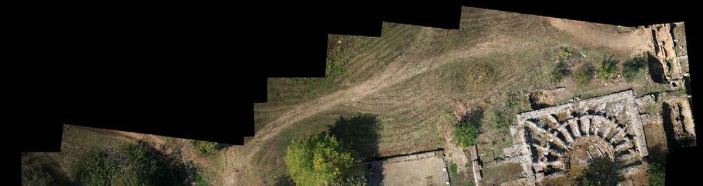
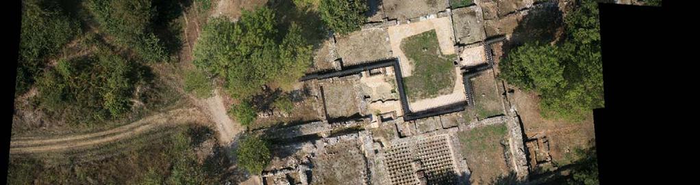
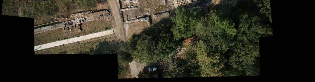
Worth a thousand words Photogrammetry for archaeological 3D surveying
 9 Worth a thousand words Photogrammetry for archaeological 3D surveying After a period during which laser scanners have dominated surveying applications, photogrammetry is slowly coming back, both at research
RAPID 3D SCENE RECONSTRUCTION FROM KITE-BASED AERIAL IMAGERY USING OPEN SOURCE STRUCTURE FROM MOTION
 RAPID 3D SCENE RECONSTRUCTION FROM KITE-BASED AERIAL IMAGERY USING OPEN SOURCE STRUCTURE FROM MOTION A Thesis Project submitted in partial fulfillment of the requirements for the degree of Masters of Science
Contents. Contents. Perfecting people shots Making your camera a friend.5. Beyond point and shoot Snapping to the next level...
 Contents 1 Making your camera a friend.5 What are the options?... 6 Ready for action: know your buttons.8 Something from the menu?... 10 Staying focused... 12 Look, no hands... 13 Size matters... 14 Setting