Improved Operational Efficiency Through 3D Laser Scanning Techniques. Presented by Grace Chia, Sales Engineer, Seatronics
|
|
|
- Deirdre Collins
- 6 years ago
- Views:
Transcription

1 Improved Operational Efficiency Through 3D Laser Scanning Techniques Presented by Grace Chia, Sales Engineer, Seatronics
2 About Us SEATRONICS The Marine Technology Specialists; Market leaders in provision of marine electronics to the subsea services market Global partners and distributors of 2G Robotics ULS range of systems 2G ROBOTICS Founded in 2007 in Waterloo, Ontario, Canada Dedicated to advanced research, development, and engineering for the production of innovative and cutting-edge solutions Over fifty systems built and deployed worldwide on all seven continents


3 Why Laser Scanning? Ultra High Resolution that could not be achieved previously Time savings


4 Basic Principles of Operation: Triangulation Stationary Scanning Dynamic Scanning points 50 deg FOV 52 Hz laser line capture 52 Hz laser line capture


5 Data Processing Data is captured in real-time and can be easily processed while still offshore.xyz conforming to LAS data output. Dedicated drivers in EIVA, HYPACK, and QPS software.


6 What is available from 2G? ULS-100 Stationary Only 0.13m to 1m range ULS-200 Stationary Only 0.25m to 2.5m range Typical Applications: Interior pipes, tubes, tunnels, piles Small size damage or asset condition Flume tanks and sediment experiments Confined spaces Basic Specs: 480 points per line 9 lines/s 360 degree rotation, 50 degree laser swath mm resolution RS-485 communication protocol 350m depth rating


7 What is available from 2G? ULS-500 PRO Dynamic or Stationary 1.5m to 20m range Rotary Actuator for stationary scanning ULS-500 PRO Accessories SeaShot Imager Stills Camera & SeaShot LED Typical Applications Spool metrology As-built surveys Damage assessment Pipelines AUV integrations Basic Specs 2048 points/line 52 Hz laser line capture; ~90Hz in pre-release PPS time synchronization for vehicle integrations 4000m depth rating Gb Ethernet


8 Operating Conditions
 If you can see if with a camera, the laser will work!")
9 Operating Conditions Laser Range = Visibility Range (up to 20m) If you can see if with a camera, the laser will work!

10 Operating Conditions Ambient Light = More Noise More Outlier Points Will Appear In The Scan

11 Operating Conditions Shiny objects are difficult to scan since the laser reflects off the object at defined angles and not back towards the sensor.

12 Operating Conditions Further Distance = More Coverage, but More Gaps Between Points

13 Case Studies: Oil and Gas

14 Dynamic Spool Metrology Company DOF Subsea Location The Underwater Centre, UK Objective Dynamic ROV Metrology Survey Product ULS-500 Pro

15 Dynamic Spool Metrology The two target structures were laid on the sea floor in a water depth of approximately 32m and approximately 18m apart. They were rotated to roughly align the small flanges. 2GR ULS 500 Pro system Sonardyne Sprint AAINS system and Syrinx DVL Sonardyne ROVNAV 6 Mini SVS Paroscientific DQ CTD Gen 5 Multiplexer Mobilised on board The Underwater Centre XL ROV

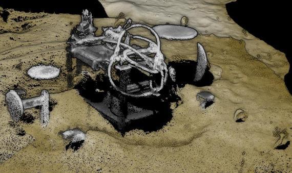
16 Dynamic Spool Metrology

17 Comparison to LBL Results
18 Operational Efficiency 15m hub to hub metrology completed in 20 minutes- 4 scans 3 of which were redundant. Compared to stationary laser scanner approach which took 6 hours Operational in conditions where other systems couldn t operate due to proximity of ROV ranges to target. Contactless method of performing metrologies Real time 3D data in large volumes Seabed profile Inherent part of the delivery (3D point cloud) Minimal Calibration Auto-calibration, mechanical integration,... Reduced operational vessel and ROV time!
19 Operational Efficiency The benefits of mobile laser metrology may be summarised as follows: Non-Intrusive - no prior subsea intervention is required in advance of metrology, and no subsea bracketry, control spheres or metrology aids are required. Flexible Deployment - modular system which can be easily fitted to an ROV (for Dynamic data acquisition), or mounted onto a tripod (for static data acquisition). Time to Survey - significant reduction in the time (and therefore vessel cost) needed to gather the survey data in comparison to traditional techniques such as pure acoustic LBL. Time to Data - quick delivery of results offshore; typically within six hours of data acquisition. It is normal for data processing to be conducted in parallel with array recovery operations. Inferred Metrology - with prior dimensional control information, hub position and orientation can be inferred using laser scan data. More than Metrology - the 3D model used for metrology serves as an As-Built model of the subsea installation and the surrounding area to provide a baseline for future intervention work.
20 User Feedback The parallel development of high resolution underwater laser and high precision acoustically aided inertial navigation has revolutionized the capability to perform mobile metrology operations in a timescale previously unattainable. DOF Subsea Mobile Laser Metrology Report SV-CL C It is now entirely practical to deploy a limited LBL array in close proximity to the targets and conduct high speed data acquisition operations followed by immediate processing on board the vessel. Preliminary results are typically available within hours of deploying the array, thus saving significant vessel time and allowing operational decisions to be made without delay. DOF Subsea Mobile Laser Metrology Report SV-CL C

21 Oilfield Mapping and Metrology (2016+) Company Confidential Location Ghana, Africa 1300m water depth Objective Dynamic ROV Survey of a problematic oilfield for condition assessment. Included spool metrology and pipeline surveying. Product ULS-500
22 Oilfield Mapping and Metrology (2016+)
23 Oilfield Mapping and Metrology (2016+)
24 Oilfield Mapping and Metrology (2016+)

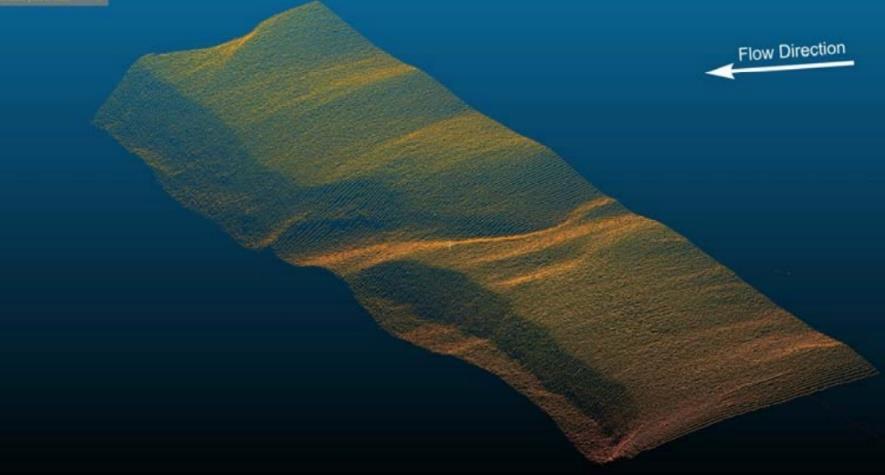
25 Hugin AUV Pipeline and Seabed Mapping Company Oceaneering Survey Services Location Global Objective Free span detection, pipeline movement, other damage. 7 Oceaneering Owned ULS-500 s operating on 6 Hugins worldwide. Over 10,000km of pipeline scanned with ULS- 500 to date. Product ULS-500
: Concrete Mattresses for Cross Over")
26 Hugin AUV Pipeline and Seabed Mapping Sample Results (1): Concrete Mattresses for Cross Over Pipes
: Buoyancy")
27 Hugin AUV Pipeline and Seabed Mapping Sample Results (2): Buoyancy Collars
: With Stills")
28 Hugin AUV Pipeline and Seabed Mapping Sample Results (3): With Stills Overlay

29 I-Tube Inspection (2015) Company Ocean Atlantic Petroleum Location Angola Objective Geometry and Ovality of 44 ID I-Tube to facilitate installation of high power umbilical cable Product ULS-200
 Solution:")

30 I-Tube Inspection (2015) Solution: Spring Actuated Centralizer Frame with ULS 200

31 Marine Archeology & Salvage

32 U-576 WWII U-Boat Survey (2016) Company NOAA Location 30 miles offshore North Carolina, USA >200m depth Objective Provide 3D documentation of an underwater WWII battlefield Solution ULS-500 PRO interfaced with EIVA NaviSuite and attached to a frame mounted to a Triton 1000/2 submarine with SPRINT for positioning

33 U-576 WWII U-Boat Survey (2016) Range: 15m+ Up to 30,720 points/sec 30 profiles/sec Integrated stills imaging and smart subsea light

34 U-576 WWII U-Boat Survey (2016)

35 Costa Concordia Salvage ( ) Company ADUS DeepOcean Location Tyrrhenian Sea, Italy Objective Assess damage to underwater portion of the Costa Concordia during the salvage operation. Produce point cloud model of the entire underwater portion of starboard hull. Product ULS-500

36 Costa Concordia Salvage ( )
 Close Up 3D Point")
: Close up of 3D Point")
37 Costa Concordia Salvage ( ) Close Up 3D Point Clouds Details Sample Results (1): Close up of 3D Point Cloud Details
38 Scientific Research


39 Sediment Transport Company: Genex Systems Location: Turner Fairbank Highway Research Center, VA Objective: Measuring real-time sediment bed load Product: ULS-100
40 Things to consider about Laser Scanning What is the resolution required? What is the range that the project can offer? Is it better to do it in Scan Mode or Profile Mode?
41 Thank you for your time! Any Questions?
Improved Operational Efficiency with Laser Scanning Scott Gray, Operations Manager, Seatronics Ltd.
 Improved Operational Efficiency with Laser Scanning Scott Gray, Operations Manager, Seatronics Ltd. Overview ULS Underwater Laser Systems Trade-offs with Sonar and laser System Operation Results Preview
The Use of Sonardyne SPRINT INS, Syrinx DVL & 6G Acoustics to Enable Dynamic Laser Mapping and Metrology
 The Use of Sonardyne SPRINT INS, Syrinx DVL & 6G Acoustics to Enable Dynamic Laser Mapping and Metrology Simon Waterfield Survey Support Group Manager, Sonardyne International Ltd. Agenda Key enablers
New underwater contactless metrology and inspection approach using photogrammetric integrated system
 New underwater contactless metrology and inspection approach using photogrammetric integrated system The leading Edge of Value-Based Subsea Inspection, SUT, Aberdeen, 1 st November 2017 1 ORUS 3D SYSTEM
TAKING LIDAR SUBSEA. Adam Lowry, Nov 2016
 TAKING LIDAR SUBSEA Adam Lowry, Nov 2016 3D AT DEPTH Based in the technology hub of Boulder, Colorado, 3D at Depth is dedicated to the development of underwater laser measurement sensors and software Patented
Deepwater Spoolpiece Metrology and INS
 Deepwater Spoolpiece Metrology and INS ir. Wilbert Brink AVANS Hogeschool - 16 June 2009 Introduction What is a deepwater spoolpiece metrology? What is the classical way of doing a metrology? How can we
10 Years of Implied Metrology. Stewart Cannon 4D Nav
 10 Years of Implied Metrology Stewart Cannon 4D Nav Green Canyon Area of Gulf of Mexico 150 miles south of New Orleans First oil 2007 Oil and Gas exported via Caesar and Cleopatra pipeline systems Two
INS aided subsurface positioning for ROV surveys
 INS aided subsurface positioning for ROV surveys M. van de Munt, Allseas Engineering B.V., The Netherlands R van der Velden, Allseas Engineering B.V., The Netherlands K. Epke, Allseas Engineering B.V.,
DYNAMIC POSITIONING CONFERENCE September 16-17, Sensors
 DYNAMIC POSITIONING CONFERENCE September 16-17, 2003 Sensors An Integrated acoustic positioning and inertial navigation system Jan Erik Faugstadmo, Hans Petter Jacobsen Kongsberg Simrad, Norway Revisions
Data, Data, Everywhere. We are now in the Big Data Era.
 Data, Data, Everywhere. We are now in the Big Data Era. CONTENTS Background Big Data What is Generating our Big Data Physical Management of Big Data Optimisation in Data Processing Techniques for Handling
Machine Vision based Data Acquisition, Processing & Automation for Subsea Inspection & Detection
 Machine Vision based Data Acquisition, Processing & Automation for Subsea Inspection & Detection 1 st Nov 2017 SUT Presentation: The Leading Edge of Value Based Subsea Inspection Adrian Boyle CEO Introduction
Using Close Range Photogrammetry to meet Offshore Platform Construction and Installation Requirements
 Using Close Range Photogrammetry to meet Offshore Platform Construction and Installation Requirements Simon Manser, BP Exploration for Hydro14 Clair Phase II Project - Clair Ridge UKCS West of Shetland
UNDERWATER ACOUSTIC MODEMS PRODUCT INFORMATION GUIDE
 UNDERWATER ACOUSTIC MODEMS PRODUCT INFORMATION GUIDE EvoLogics Underwater Acoustic Modems EvoLogics underwater acoustic modems provide full-duplex digital communication using EvoLogics' patented S2C (Sweep-
RESEARCH VESSELS. Full Picture Delivery
 RESEARCH VESSELS Reflections and suggestions related to installation of hydroacoustic systems onboard research vessels with main focus on ice breakers Full Picture Delivery 5. DEKK 4. DEKK 3. DEKK 2. DEKK
UndErwatEr acoustic modems. product information GUidE
 UndErwatEr acoustic modems product information GUidE evologics s2c R - series underwater acoustic modems EvoLogics S2CR - series underwater acoustic modems provide full-duplex digital communication using
Inertial Systems. Ekinox Series TACTICAL GRADE MEMS. Motion Sensing & Navigation IMU AHRS MRU INS VG
 Ekinox Series TACTICAL GRADE MEMS Inertial Systems IMU AHRS MRU INS VG ITAR Free 0.05 RMS Motion Sensing & Navigation AEROSPACE GROUND MARINE Ekinox Series R&D specialists usually compromise between high
3D Hydrographic Mapping for Real-Time Underwater Assessment Blair Cunningham, President of Technology Lakeland, Florida
 3D Hydrographic Mapping for Real-Time Underwater Assessment Blair Cunningham, President of Technology Lakeland, Florida Marine Products Solution Experts Salt Lake City, UT Lakeland, FL Edinburgh, UK Portland,
Teledyne BlueView. Making Impossible Jobs Possible. Teledyne BlueView Product Guide
 Product Guide Making Impossible Jobs Possible COMPANY PRODUCT GUIDE High-Resolution Underwater Acoustic Imaging, Measurement, and Automation Systems Product Guide Making Impossible Jobs Possible Teledyne
600M SPECTRE FIBEROPTIC ROV SYSTEM
 Science Class ROV 600M SPECTRE FIBEROPTIC ROV SYSTEM General Specifications Dimensions: 60.0 L x 35.0 W x 33.0 H Weight: 795 pounds Payload: 30-75 pounds Tilt Assembly: 270 Pan - 90 Tilt Forward Thrust:
Argus Remote Systems a/s. Argus Abyss Features. 1 of 1
 Argus Abyss Features The Argus Abyss delivers almost equivalent performance to current work class systems, but is smaller and lighter and can easily be configured for a wide range of functions. Argus Abyss
5 member consortium o University of Strathclyde o Wideblue o National Nuclear Laboratory o Sellafield Ltd o Inspectahire
 3 year, 1.24M Innovate UK funded Collaborative Research and Development Project (Nuclear Call) o Commenced April 2015 o Follows on from a successful 6 month Innovate UK funded feasibility study 2013-2014
1.0 SIDESCAN SONAR SYSTEMS
 1.0 SIDESCAN SONAR SYSTEMS 1.1 - Geoacoustics 160D Dual Frequency Sidescan Sonar System (1000m rated) inclusive of :- 1 x Geoacoustics SS941 Transceiver 1 x Geoacoustics 159D Towfish (100/410Khz) 1 x Deck
Displayed with permission The American Surveyor April/May Copyright 2009 Cheves Media
 NASA s Environmental Simulation Chamber A at the Johnson Space Center in Houston will require upgrades to accommodate testing of components for the new space telescopes. Laser scanning with the FARO LS
Merlin vessel-based lidar system
 Brochure: Merlin vessel-based lidar system Merlin vessel-based lidar system Map the full environment in one pass Scanning the full marine environment in a single operation reduces the amount of time crew
On Efficient Data Collection and Event Detection with Delay Minimization in Deep Sea
 On Efficient Data Collection and Event Detection with Delay Minimization in Deep Sea Huangyang Zheng and Jie Wu Computer and Information Sciences Temple University 1. Introduction Efficient searching in
Compatt 5 Transponder
 SONARDYNE NAVIG VIGATION SYSTEMS Compatt 5 Transponder The world s most capable acoustic navigation transponder Designed for 1 Compatt 5 Compatt, the Computing and telemetry transponder, has been the market-leader
THE ROBOT-MOUNTED OPTICAL CMM 3D SCANNERS FOR AUTOMATED INSPECTION
 METROLOGY SOLUTIONS THE ROBOT-MOUNTED OPTICAL CMM 3D SCANNERS FOR AUTOMATED INSPECTION Accelerate your industrial inspection processes by bringing quality control as close to the part as possible. For
Proceedings of Western Dredging Association and Texas A&M University Center for Dredging Studies' "Dredging Summit and Expo 2015"
 Proceedings of Western Dredging Association and Texas A&M University Center for Dredging Studies' DYNAMIC UNDERWATER 3D SURVEY AND MONITORING DURING RECENT PLATFORM DREDGING OPERATION: REDUCING RISK AND
What s new in version 1.4. INSTALATION AND OPERATION MANUAL ABYSSAL OS Overlay Module Version 1.4
 What s new in version 1.4 INSTALATION AND OPERATION MANUAL ABYSSAL OS Overlay Module Version 1.4 1 What s new in version 1.4 Thank you for purchasing the Abyssal OS Overlay Module for your ROV. This instruction
Leica High-Definition Surveying Systems. Leica HDS3000. The Industry Standard for High-Definition Surveying
 Leica High-Definition Surveying Systems Leica HDS3000 The Industry Standard for High-Definition Surveying HDS High-Definition Surveying TM : Laser Scanning Redefined High-Definition Surveying, or HDS,
The Leica HDS Family. The Right Tool for the Job HDS3000 HDS2500 HDS4500. Cyclone & CloudWorx. Press the QuickScan button to define the field-of-view.
 HDS2500 High accuracy scanner, ideal for fixed or raised installations when leveled tripod mounting is not practical, or areas with less stringent field-of-view requirements. The Leica HDS Family Time-of-flight
3D Measurement and Control, Made Easy
 3D Measurement and Control, Made Easy WHAT WE DO LMI Technologies is a global leader in 3D scanning, visualization, measurement, and control technology. We focus on developing products to deliver a customer
US foundry Bradken implements optical measuring technology
 Application Note US foundry Bradken implements optical measuring technology Location / country: Tacoma / Washington, USA GOM systems: ATOS Triple Scan, TRITOP GOM software: ATOS Professional Sector: Power
ADVANCED CRAWLER TECHNOLOGIES
 ADVANCED CRAWLER TECHNOLOGIES 233 Jan Smuts Ave Parktown North Johannesburg South Africa Tel. 27 10 900 4073 www.ryonic.io info@ryonic.io Product Overview RMIS Key Features Overview The RMIS crawler is
Laser-based metrology for Hexapods Symétrie
 Laser-based metrology for Symétrie Automated Precision Europe GmbH Im Breitspiel 17 69126 Heidelberg Tel: +49 (0) 6221 729 805 0 Fax: +49 (0) 6221 729 805 23 HEXAPODS The six feet for special applications
Sensor Fusion: Potential, Challenges and Applications. Presented by KVH Industries and Geodetics, Inc. December 2016
 Sensor Fusion: Potential, Challenges and Applications Presented by KVH Industries and Geodetics, Inc. December 2016 1 KVH Industries Overview Innovative technology company 600 employees worldwide Focused
NEW. Very high-speed profile measurement for industrial in line applications. 2D/3D profile sensor SENSORS & SYSTEMS
 SENSORS & SYSTEMS SENSORS & SYSTEMS By far the better solution PRINCIPLE NEW 28 Very high-speed profile measurement for industrial in line applications. High accuracy and very high frame frequency thanks
> > Cut training costs: The low-maintenance Merlin. > > Add value: By expanding your product offering,
 45 27 39.384 N 9 07 30.145 E Merlin Vessel-based lidar system Map the full environment in one pass Scanning the full marine environment in a single operation reduces the amount of time crew spend in hazardous
Laser profile sensor, laser scanner 2D/3D for beads and grooves
 Laser profile sensor, laser scanner 2D/3D for beads and grooves Industrial laser profile sensor, 2D/3D laser scanner for fast CMOS profile measurement and laser line for beads and grooves, dimension, position
PRODUCT BROCHURE SCANNING SOLUTIONS PORTABLE LASER SCANNING WITH THE LEICA ABSOLUTE TRACKER
 PRODUCT BROCHURE SCANNING SOLUTIONS PORTABLE LASER SCANNING WITH THE LEICA ABSOLUTE TRACKER INTRODUCTION THE RIGHT SOLUTION FOR EVERY SCANNING APPLICATION Hexagon Manufacturing Intelligence s portable
5 member consortium o University of Strathclyde o Wideblue o National Nuclear Laboratory o Sellafield Ltd o Inspectahire
 Summan, Rahul and Mathur, Neha and Dobie, Gordon and West, Graeme and Marshall, Stephen and Mineo, Carmelo and MacLeod, Charles Norman and Pierce, Stephen and Kerr, William (2016) Mosaicing for automated
Evaluating the Performance of a Vehicle Pose Measurement System
 Evaluating the Performance of a Vehicle Pose Measurement System Harry Scott Sandor Szabo National Institute of Standards and Technology Abstract A method is presented for evaluating the performance of
APPLICATIONS AND CHALLENGES FOR UNDERWATER SWIMMING MANIPULATORS
 APPLICATIONS AND CHALLENGES FOR UNDERWATER SWIMMING MANIPULATORS Jørgen Sverdrup-Thygeson AMOS Days October 2017 Introduction NEEDS FOR SUBSEA INSPECTION, MAINTENANCE AND REPAIR The number of new subsea
LaserFleX New Generation of High Performance Infrastructure Measurement System
 Balfour Beatty Rail LaserFleX New Generation of High Performance Infrastructure Measurement System LaserFleX TM Introduction LaserFleX TM is the modular railway infrastructure and track measurement system
Transducer and LBL calibration - Integrated functions in HiPAP systems
 Transducer and LBL calibration - Integrated functions in HiPAP systems Dynamic Positioning Conference, Houston, September 17-18 2002 arranged by 1 Calibration of transducer alignment and of LBL array This
The Most User-Friendly 3D scanner
 The Most User-Friendly 3D scanner The Solutionix C500 is optimized for scanning small- to medium-sized objects. With dual 5.0MP cameras, the C500 provides excellent data quality at a high resolution. In
Offshore renewables structural monitoring. Safeguarding the quality and productivity of your offshore wind farm assets.
 Offshore renewables structural monitoring Safeguarding the quality and productivity of your offshore wind farm assets. Strainstall / Offshore renewables structural monitoring Specialist offshore expertise
Mobile LiDAR for Ground Applications. Spar 2006, March Paul Mrstik, Terrapoint Canada Inc. Craig Glennie, Terrapoint USA LLC
 Mobile LiDAR for Ground Applications Spar 2006, March 27 2006 Paul Mrstik, Terrapoint Canada Inc. Craig Glennie, Terrapoint USA LLC Agenda Introduction to Terrapoint What is mobile LiDAR? Advantages of
Three-Dimensional Laser Scanner. Field Evaluation Specifications
 Stanford University June 27, 2004 Stanford Linear Accelerator Center P.O. Box 20450 Stanford, California 94309, USA Three-Dimensional Laser Scanner Field Evaluation Specifications Metrology Department
ROMER ABSOLUTE ARM ADVANCED PORTABLE 3D MEASUREMENT PRODUCT BROCHURE
 ROMER ABSOLUTE ARM ADVANCED PORTABLE 3D MEASUREMENT PRODUCT BROCHURE RANGE CHOOSE ACCURACY Meeting the Demands of Measurement Each ROMER Absolute Arm model is available at different accuracy levels to
DIMENSIONAL INSPECTION IN QUALITY CONTROL
 THE COMPLETE SOLUTION FOR DIMENSIONAL INSPECTION IN QUALITY CONTROL APPLICATIONS METROLOGY SOLUTIONS ARE QUALITY CONTROL ISSUES IMPACTING YOUR BOTTOM LINE? Creaform s comprehensive range of portable and
Toward Real-Time Visually Augmented Navigation for Autonomous Search and Inspection of Ship Hulls and Port Facilities
 Toward Real-Time Visually Augmented Navigation for Autonomous Search and Inspection of Ship Hulls and Port Facilities Ryan M. Eustice Dept. of Naval Architecture & Marine Engineering University of Michigan
GPS-Aided Inertial Navigation Systems (INS) for Remote Sensing
 for Remote Sensing") GPS-Aided Inertial Navigation Systems (INS) for Remote Sensing www.inertiallabs.com 1 EVOLUTION OF REMOTE SENSING The latest progress in Remote sensing emerged more than 150 years ago, as balloonists took
GPS-Aided Inertial Navigation Systems (INS) for Remote Sensing www.inertiallabs.com 1 EVOLUTION OF REMOTE SENSING The latest progress in Remote sensing emerged more than 150 years ago, as balloonists took
(Subsea) Keith Vickery Zupt LLC
 Keith Vickery Zupt LLC") (Subsea) Keith Vickery Zupt LLC kv@zupt.com Offshore subsea infrastructure surveys (pipeline inspection, well, XT, and manifold inspections) are required to ensure compliance with both internal operator,
(Subsea) Keith Vickery Zupt LLC kv@zupt.com Offshore subsea infrastructure surveys (pipeline inspection, well, XT, and manifold inspections) are required to ensure compliance with both internal operator,
Active Camouflage of Underwater Assets (ACUA)
") Active Camouflage of Underwater Assets (ACUA) Kendall L. Carder University of South Florida, College of Marine Science 140 7 th Avenue South, St. Petersburg, FL 33701 phone: (727) 553-3952 fax: (727) 553-3918
Active Camouflage of Underwater Assets (ACUA) Kendall L. Carder University of South Florida, College of Marine Science 140 7 th Avenue South, St. Petersburg, FL 33701 phone: (727) 553-3952 fax: (727) 553-3918
New Approach in Non- Contact 3D Free Form Scanning
 New Approach in Non- Contact 3D Free Form Scanning Contents Abstract Industry Trends The solution A smart laser scanning system Implementation of the laser scanning probe in parts inspection Conclusion
MONITORING OF THE SUBMERGED STRUCTURES OF DAMS
 MONITORING OF THE SUBMERGED STRUCTURES OF DAMS E Isomäki 1 and K Hänninen 2 1. ELY Centre for Häme, Hämeenlinna, Finland 2. VRT Finland, Jyväskylä, Finland PUBLISHED IN ICOLD SYMPOSIUM 2016, SOUTH AFRICA
Trident Pig Tracking Series
 Trident Pig Tracking Series Trident EM Transmitters The Trident series Electromagnetic Transmitters have been developed by Propipe Limited for use with pipeline pigs for identification, tracking and locating.
Terrestrial 3D laser scanning Practical aspects
 Terrestrial 3D laser scanning Practical aspects ISPRS WG VI/5&SC Summer School 2007 by Gregor Bilban 3D laser scanning Benefits Lower data collection costs Reduction or elimination of re-visits More accurate
Application of Hydrodynamics and Dynamics Models for Efficient Operation of Modular Mini-AUVs in Shallow and Very-Shallow Waters
 Application of Hydrodynamics and Dynamics Models for Efficient Operation of Modular Mini-AUVs in Shallow and Very-Shallow Waters P. Ananthakrishnan Department of Ocean Engineering Florida Atlantic University
Motion estimation of unmanned marine vehicles Massimo Caccia
 Motion estimation of unmanned marine vehicles Massimo Caccia Consiglio Nazionale delle Ricerche Istituto di Studi sui Sistemi Intelligenti per l Automazione Via Amendola 122 D/O, 70126, Bari, Italy massimo.caccia@ge.issia.cnr.it
Who we are Swathe Services offers: Equipment Sales Equipment Rental Experience Hydrographic Surveyors Turn-key survey support
 Swathe Services our results speak for themselves Who we are Swathe Services offers: Equipment Sales Equipment Rental Experience Hydrographic Surveyors Turn-key survey support Dissertation Title High Resolution
Stereophotogrammetry: a future-proof digital tool for the subsea industry
 Stereophotogrammetry: a future-proof digital tool for the subsea industry Martin Sayer BSc PhD MAE FSUT Andrew Mogg BSc PhD Tritonia Scientific Ltd. Disclaimer: Whereas our company uses proprietary software
New Sony DepthSense TM ToF Technology
 ADVANCED MATERIAL HANDLING WITH New Sony DepthSense TM ToF Technology Jenson Chang Product Marketing November 7, 2018 1 3D SENSING APPLICATIONS Pick and Place Drones Collision Detection People Counting
INSTALATION AND OPERATION MANUAL ABYSSAL OS Overlay Module Version 1.2
 INSTALATION AND OPERATION MANUAL ABYSSAL OS Overlay Module Version 1.2 Thank you for purchasing the Abyssal OS Overlay Module for your ROV. This instruction manual contains all the information you ll need
INNOVATUM REFERENCE MANUALS. Section 4-1. Smartrak Description & Installation
 INNOVATUM REFERENCE MANUALS Section 4-1 Smartrak Description & Installation The electronic version of this document is the controlled copy. All printed versions are thus uncontrolled and may not be current.
Delph. Seabed Mapping Software Suite FEATURES ABOUT DELPH SOFTWARE SUITE BENEFITS APPLICATIONS
 Delph Seabed Mapping Software Suite Delph Seismic, Delph Sonar and Delph Mag are complete software packages with dedicated acquisition, processing and interpretation components. They operate with any sidescan
ZEISS COMET LƎD 2 Simple and quick 3D measurements. The new, mobile system for optical 3D scanning
 ZEISS COMET LƎD 2 Simple and quick 3D measurements The new, mobile system for optical 3D scanning COMET LƎD 1 Success Story 2011 May COMET LƎD 2M first presentation at Control 2011 2011 December COMET
3D Laser Scanner. Fast, Portable, Accurate. Long range laser scanner Modular design configured to suit your survey needs
 3D Laser Scanner Fast, Portable, Accurate Long range laser scanner Modular design configured to suit your survey needs Introducing the Maptek I-Site 8820 laser scanner The Maptek I-Site 8820 laser scanner
Video Endoscopic Metrology for Pipeline Welding
 SINCE2013 Singapore International NDT Conference & Exhibition 2013, 19-20 July 2013 Video Endoscopic Metrology for Pipeline Welding Alfred Ng GE Measurement & Control, Inspection Technologies, a.ng@ge.com
> Acoustical feedback in the form of a beep with increasing urgency with decreasing distance to an obstacle
 PARKING ASSIST TESTING THE MEASURABLE DIFFERENCE. > Creation of complex 2-dimensional objects > Online distance calculations between moving and stationary objects > Creation of Automatic Points of Interest
Multiplexers and Telemetry Solutions for Underwater Tech
 REPRINT Multiplexers and Telemetry Solutions for Underwater Tech NEXUS Range Ensures High Data Transmission By Jes Højlund Dr. Ole Aarup Mikkelsen With the development of more demanding sensor suites,
LAIR. UNDERWATER ROBOTICS Field Explorations in Marine Biology, Oceanography, and Archeology
 UNDERWATER ROBOTICS Field Explorations in Marine Biology, Oceanography, and Archeology COS 402: Artificial Intelligence - Sept. 2011 Christopher M. Clark Outline! Past Projects! Maltese Cistern Mapping!
Quality Control with 4D Nav s QCView Software. Rig Move QA/QC Operations Using QCView. Case Study 1: Drillship Rig Move
 Quality Control with 4D Nav s QCView Software 4D Nav has introduced a software package designed to provide advanced QC capabilities for offshore operations. This paper describes some of the capabilities
AICON MoveInspect XR8
 AICON MoveInspect XR8 PORTABLE. ROBUST. ACCURATE. PRODUCT BROCHURE THE NEW BENCHMARK FOR INSPECTION, TRACKING AND POSITIONING Today, every company has to meet the challenge to develop products within shorter
INFOMAR: An Introduction and Invitation to INFOMAR 2012
 INFOMAR: An Introduction and Invitation to INFOMAR 2012 Koen Verbruggen Presented by Janine Guinan Geological Survey of Ireland 10 th October, 2012 GEOSEAS Seminar Cork Context UNCLOS 1996 Area mapped
MOBILE INSPECTION SYSTEM FOR HIGH-RESOLUTION ASSESSMENT OF TUNNELS
 MOBILE INSPECTION SYSTEM FOR HIGH-RESOLUTION ASSESSMENT OF TUNNELS M. Gavilán*, F. Sánchez, J.A. Ramos and O. Marcos EUROCONSULT GROUP Avenida Montes de Oca 9-11, 28703, Madrid, Spain *Corresponding author:
BENCHMIKE PRO NEW. The Industry s leading off-line diameter & ovality measurement system
 BENCHMIKE PRO NEW The Industry s leading off-line diameter & ovality measurement system Industry s leading sample inspection system Measure manufactured cut samples fast and with the highest accuracy in
BENCHMIKE PRO NEW. The Industry s leading off-line ID/OD/Wall measurement system
 BENCHMIKE PRO NEW The Industry s leading off-line ID/OD/Wall measurement system Industry s leading sample inspection system Measure manufactured cut samples fast and with the highest accuracy in the industry
Trimble MX2 mobile mapping
 Trimble MX2 mobile mapping user applications Point clouds within your reach The Trimble MX2 is a vehicle-mounted spatial imaging system which combines high resolution laser scanning and panoramic cameras
Trimble Business Center Software, v3.30
 Trimble Business Center Software, v3.30 We are pleased to announce a new version of the Trimble Business Center software, version 3.30. This new version includes over 30 new features and enhancements increasing
THE ROBOT-MOUNTED OPTICAL CMM 3D SCANNERS FOR AUTOMATED INSPECTION
 METROLOGY SOLUTIONS THE ROBOT-MOUNTED OPTICAL CMM 3D SCANNERS FOR AUTOMATED INSPECTION Accelerate your industrial inspection processes by bringing quality control as close to the part as possible. For
BLAZE 600M HIGH-ACCURACY BLUE LIGHT MEASUREMENT SYSTEM PRODUCT BROCHURE
 BLAZE 600M HIGH-ACCURACY BLUE LIGHT MEASUREMENT SYSTEM PRODUCT BROCHURE BLAZING SPEED, DAZZLING PERFORMANCE The BLAZE 600M portable blue light measurement system from Hexagon Manufacturing Intelligence
Version 3.0. SolidCitricTM. product presentation
 Version 3.0 product presentation SolidCitric Product overview SolidCitric products Interface to be treated SolidCitric Product overview SolidCitric products Interface to be treated SolidCitric How it Works
BENCHMIKE 283 SERIES. Off-Line ID/OD/Wall measurement systems for pipe and tube samples
 BENCHMIKE 283 SERIES Off-Line ID/OD/Wall measurement systems for pipe and tube samples Measure manufactured parts or cut samples fast and with the highest accuracy Perform reliable, non-contact measurements
Making a Visible Difference THE INSPECTION SPECIALISTS ENERGY OIL & GAS PHARMACEUTICALS PETROLEUM RETAIL PROCESS INDUSTRIES PHYSICAL ASSETS
 Making a Visible Difference ENERGY OIL & GAS PHARMACEUTICALS PETROLEUM RETAIL PROCESS INDUSTRIES PHYSICAL ASSETS Inspectahire Instrument Company Ltd have an extensive hire pool of equipment that can be
Visual inspection Better than your eyes
 International Conference Nuclear Energy for New Europe 2005 Bled, Slovenia, September 5-8, 2005 Visual inspection Better than your eyes Norbert Jakobs Framatome ANP GmbH Freyeslebenstrasse 1, 91058 Erlangen
3D Metrology with Laser Triangulation
 Seite: 1 Light Section Sensors and Cameras Seite: 3 Agenda 3D Laser Triangulation Overview Customer requirements classification How do we meet these requirements? Products Performance Integration Application
HawkEye III - A new deep penetrating bathymetric LIDAR system
 Please insert a picture (Insert, Picture, from file). Size according to grey field (10 cm x 25.4 cm). Scale picture: highlight, pull corner point Cut picture: highlight, choose the cutting icon from the
Company overview. PolyWorks 3D metrology software helps oil field equipment manufacturer cut motor component inspection time in half
 Company overview PolyWorks 3D metrology software helps oil field equipment manufacturer cut motor component inspection time in half Weatherford International Ltd. (NYSE: WFT) is one of the world s largest
Environmental Services Integrated Video Mapping SystemTM
 Environmental Services Integrated Video Mapping SystemTM OVERVIEW The collection and management of data during a field investigation is complex. The inputs of many sampling and measurement devices must
Acuity. Acuity Sensors and Scanners. Product Brochure
 Acuity Acuity Sensors and Scanners Product Brochure CCS PRIMA The CCS Prima series of confocal displacement sensors are amongst the most precise measuring instruments in the world. Using a confocal chromatic
ROAD SURFACE STRUCTURE MONITORING AND ANALYSIS USING HIGH PRECISION GPS MOBILE MEASUREMENT SYSTEMS (MMS)
") ROAD SURFACE STRUCTURE MONITORING AND ANALYSIS USING HIGH PRECISION GPS MOBILE MEASUREMENT SYSTEMS (MMS) Bonifacio R. Prieto PASCO Philippines Corporation, Pasig City, 1605, Philippines Email: bonifacio_prieto@pascoph.com
ROAD SURFACE STRUCTURE MONITORING AND ANALYSIS USING HIGH PRECISION GPS MOBILE MEASUREMENT SYSTEMS (MMS) Bonifacio R. Prieto PASCO Philippines Corporation, Pasig City, 1605, Philippines Email: bonifacio_prieto@pascoph.com
Improved Efficiency for Multi-Technology Inspections (UT and ECT)
") Improved Efficiency for Multi-Technology Inspections (UT and ECT) More info about this article: http://www.ndt.net/?id=22727 Abstract Michaël Monette 1, Lance Maggy 2, Yannick Bellerive 3 Dirk Verspeelt
Improved Efficiency for Multi-Technology Inspections (UT and ECT) More info about this article: http://www.ndt.net/?id=22727 Abstract Michaël Monette 1, Lance Maggy 2, Yannick Bellerive 3 Dirk Verspeelt
New Sony DepthSense TM ToF Technology
 ADVANCED MATERIAL HANDLING WITH New Sony DepthSense TM ToF Technology Jenson Chang Product Marketing November 7, 2018 1 3D SENSING APPLICATIONS Pick and Place Drones Collision Detection People Counting
Newsletter #6 March 2018
 Newsletter #6 March 2018 The UTOFIA product datasheet is available! The brand new datasheet for the UTOFIA camera has been released. You can download it from our website www.utofia.eu in the Downloads
BENCHMIKE 283 SERIES. BETA LaserMike. Off-Line ID/OD/Wall measurement systems for pipe and tube samples
 BENCHMIKE 283 SERIES Off-Line ID/OD/Wall measurement systems for pipe and tube samples Measure manufactured parts or cut samples fast and with the highest accuracy Perform reliable, non-contact measurements
BP GoM Fiber Optic Network: A Case Study
 BP GoM Fiber Optic Network: A Case Study Robert S. C. Munier 1, Derek Buffitt and Robert Thomas Tyco Electronics Subsea Communications LLC 412 Mt Kemble Avenue, Morristown, NJ, 07960 USA Abstract: BP GoM
S SERIES MULTIBEAM FOR SURVEY & MAPPING
 MAP IT ALL S SERIES DISCOVER A NEW WORLD WITH THE LATEST INNOVATION FROM WASSP Outstanding performance, versatility and value. That s what you expect and exactly what you get with the new S3 sonar from
Leica Geosystems Regional Public Safety Conference. Joshua Rayburn Consolidated Forensic Laboratory, Washington DC Present Date:
 Leica Geosystems Regional Public Safety Conference Joshua Rayburn Consolidated Forensic Laboratory, Washington DC Present Date: 04.15.15 2 What is a Pegasus? Portable survey-grade mobile mapping solution
NEW APPROACH FOR SAFE, FAST AND ACCURATE SURVEY OF DEEP MINE SHAFTS
 NEW APPROACH FOR SAFE, FAST AND ACCURATE SURVEY OF DEEP MINE SHAFTS by Norbert Benecke & Peter Cain DMT GmbH &Co. KG, Germany / DMT Geosciences, Canada Kinemattic Shaft Survey 2013 Page 1 Who is DMT? is