Underground 3D Scanning in Bhutan
|
|
|
- Prosper Garrison
- 6 years ago
- Views:
Transcription


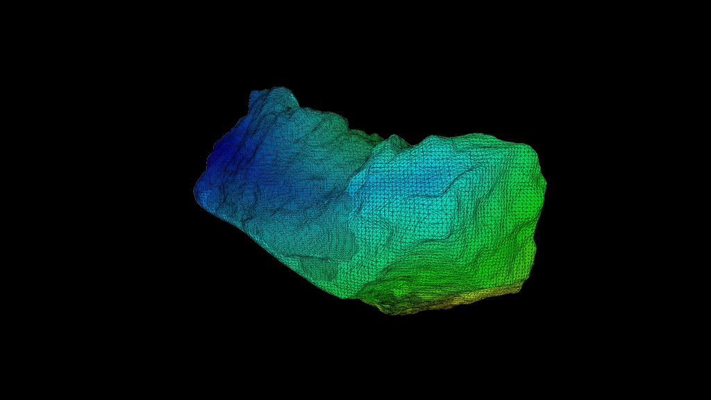
1 ARTICLE CAVITY MAPPING ABOVE COLLAPSED TUNNEL Underground 3D Scanning in Bhutan Surveying cavities in underground excavation projects can be difficult and dangerous. The collapse of a roof inside the main access tunnel at a hydroelectric dam construction site in Bhutan resulted in loss of life and a significant delay in progress. Project participants could not move forward with the tunnel work until they could ascertain the size and condition of the cavity that remained above the caved-in debris blocking the chamber. This article describes how an Indian technology application company deployed a laser scanner specially designed for cavity measurement to accurately determine the volume and dimension of the inaccessible space. In 2008, the governments of Bhutan and India committed to working jointly on the development of a multi-billiondollar hydroelectric project in Bhutan s Punatsangchhu region, along the river of the same name. With an original completion date of 2020, the entire endeavour would generate 10,000MW of power and supply electricity to millions of homes in Bhutan and India. The two governments set up the PHPA, an autonomous body involving organisations from both countries, to work on the massive undertaking. The centrepiece of the second phase of the project (called Punatsangchhu-II or PHPA-II ) would be a dam of 86 metres high and metres wide at the top. A series of tunnels, desilting chambers, surge and pressure shafts and an underground power station would be constructed, extending several kilometres from the dam site. A Deadly Collapse Excavation of a downstream surge chamber in the power station complex encountered a subterranean shear zone which resulted in a roof collapse in the main tunnel, leaving it completely blocked. This delayed the project for 1.5 years while PHPA evaluated the risk and determined how to proceed. The unplanned postponement created cost overruns and disruption to the proposed start of power delivery to customers. The problem was a lack of information about the cavity formed by the collapse of debris down into the tunnel. Before proceeding with excavation of the rubble, PHPA wanted to survey the precise location of the cavity, measure its height, width and length, and determine the overall volume of the space. In addition, project engineers hoped to gain details of the structural stability of the void area. This information would assist PHPA in evaluating the risk of digging into the soil and rock blocking the tunnel. Having already experienced loss of life in the workforce, participants feared an additional cave-in and landslide would occur if the situation was approached incorrectly. Identified Challenges PHPA retained the services of Ansari Precision Instruments Private Limited (APIPL), part of the ROTER Group of Companies, established since 1936 in India. With a core focus on the surveying of land, mines and irrigation networks, APIPL is known for its expertise in utilising the latest in high-tech surveying and mapping products. The company evaluated the options for surveying the interior of the deep, inaccessible cavern. A nearly vertical 150m-long borehole with a diameter of 205mm (the widest diameter possible with the boring equipment available to PHPA) had been drilled from the exterior down into the cavity, providing some insight for PHPA. Several challenges were identified: The cavity was too deep to use ground penetrating radar. The borehole was too narrow for common laser scanners or cameras to be lowered into the space. The bore had not been drilled perfectly straight, making insertion of any device difficult. There was evidence that the interior of the bore was unconsolidated, greatly increasing the chance an instrument could become trapped once lowered into place.
2 Devising a 3D Modelling Plan APIPL recognised that one viable solution for accurately surveying the space was to use the cavity monitoring system (CMS) developed by Teledyne Optech specifically to scan the interiors of underground areas too dangerous or difficult for personnel to reach. The laser scanner, which includes a built-in camera and integrated three-axis inclinometer, quickly collects thousands of points inside mines, caverns and other subterranean features to generate georeferenced 3D models and calculate their size, orientation and volume. Fortuitously, an upgrade of the CMS instrument, the V500, had just been introduced at the time of this project with a slimmer profile (130mm) which would fit easily inside the 205mm borehole. But despite the suitability of the cavity scanner, challenges remained. Uncertainty related to possible curves in the bore, and the unconsolidated nature of its interior walls, led APIPL to determine the existing hole was too risky. A second borehole was drilled vertically into the chamber below, taking great care to keep the drilling straight. As an added precaution, the interior of the hole was lined with steel casing. These conditions would contribute to the safe insertion and extraction of the CMS V500.

3 Preparing the CMS V500 Scanner The surveying engineers devised a plan for deploying the scanner in a way that would capture the desired data from the cavity while also ensuring the instrument would not be lost. The first concern was the depth of the target area. At 150 metres, it was likely too deep for the device to wirelessly transmit the scan data and video data to the surface via Wi-Fi. Real-time wireless data transmission is an important capability of the CMS because wires and cables must be kept to a minimum when operating in subterranean environments, where a snag can potentially result in the loss of an instrument. While the engineers did not want to risk losing the device, nor did they want to take chances that data might be lost if the Wi-Fi failed to operate at such a depth. The decision was made to set up a custom fibre-optic cable from the instrument to a tablet computer on the surface. Not only would the laser scan data be captured and monitored in real time, but live imagery from the camera would also assist the operator in proper insertion. As an added safeguard, the surveyors opted to use a vertical insertion package (VIP) offered with the CMS by Optech. The VIP s leaf-spring mechanism would keep the device steady and centred in the casing as it was lowered safely into the borehole. Capturing Survey Data

4 In preparation for the cavity scan, the surveyors first used the CMS in terrestrial mode mounted on a tripod inside the tunnel. They collected five scans of the tunnel starting at the point where the cavein occurred and then moving outward to the entrance: a total of metres. This information would be vital for representing the cavity in the correct orientation and location relative to the entire underground tunnel complex. At the location of the debris pile, the tunnel was m high and 18m wide.

5 The survey team used a total station to measure ground control points both outside and inside the tunnel to tie the captured 3D scan data into the project coordinate system. They also surveyed the surface location of the borehole. Engineers used this planning data to create a 3D model of the tunnel for incorporation into an existing terrain model of the entire site. Scanning the Cavity Prior to CMS insertion, a stand-alone inclinometer was attached to the VIP, which was lowered into the borehole by a winch on the surface over the opening. The inclinometer captured precise orientation and location data as it descended into the borehole before reaching the cavity at a depth of 152m. This test data would be cross-referenced later with the CMS scans and integrated inclinometer data to ensure the positional accuracy. Next, the system was attached to the VIP for the all-important scan collection. As the apparatus was lowered by winch, the camera-equipped CMS captured images and low-resolution scans inside the borehole, which were transmitted in real time via the fibre-optic cable to the surface. Crew members examined the imagery on a tablet as they slowly guided the device downward one metre at a time. A time stamp was made at each metre mark so the CMS scan data could be correlated with the recordings of inclinometer positional data. Once inside the cavern at 152m deep, the CMS was switched to fine scanning mode in which it acquired thousands of laser measurements. Each scan captured a point cloud with a 360 x 320-degree field of view in the void space. The inclinometer tracked the position of the scanner during each scan, and a total station mounted above the borehole surveyed the location of the VIP as the CMS was lowered. Creating a 3D Model After safe extraction of the devices, Optech CMS Desktop processing software was used to remove noise from the scan data before merging the scans into a 3D point cloud representing the entire cavity. Data from the inclinometer and total station was used to register the scans to each other and then georeference the point cloud to the coordinate system of the project site. As expected, the point cloud revealed a large cavity with undulating walls and an undefined shape. The CMS took thousands of measurements inside the cavity and the software determined its overall volume. The coordinate data precisely located the void space in the existing 3D model of the project site. This information gave the engineers a better understanding of the conditions in the area where the collapse had occurred and enabled them to begin formulating a plan to resume excavation in the main tunnel.
6
Open Pit Mines. Terrestrial LiDAR and UAV Aerial Triangulation for. Figure 1: ILRIS at work
 Terrestrial LiDAR and UAV Aerial Triangulation for Open Pit Mines Figure 1: ILRIS at work Figure 2: Geo-Copter X-8000 taking off ay what you will about the past few years, it has produced some useful tools
Using SLAM-based Handheld Laser Scanning to Gain Information on Difficult-to-access Areas for Use in Maintenance Model
 Using SLAM-based Handheld Laser Scanning to Gain Information on Difficult-to-access Areas for Use in Maintenance Model T. Makkonen a, R. Heikkilä a, P. Tölli b, F. Fedorik a a Construction Technology Research
Critical Aspects when using Total Stations and Laser Scanners for Geotechnical Monitoring
 Critical Aspects when using Total Stations and Laser Scanners for Geotechnical Monitoring Lienhart, W. Institute of Engineering Geodesy and Measurement Systems, Graz University of Technology, Austria Abstract
Integrating the Generations, FIG Working Week 2008,Stockholm, Sweden June 2008
 H. Murat Yilmaz, Aksaray University,Turkey Omer Mutluoglu, Selçuk University, Turkey Murat Yakar, Selçuk University,Turkey Cutting and filling volume calculation are important issues in many engineering
What can I model using RS 3?
 What can I model using RS 3? We are often asked about the modeling capabilities of RS 3, and whether or not the program can model certain situations. This article addresses many of your RS 3 modeling questions,
Surveying Prof. Bharat Lohani Indian Institute of Technology, Kanpur. Lecture - 1 Module - 6 Triangulation and Trilateration
 Surveying Prof. Bharat Lohani Indian Institute of Technology, Kanpur Lecture - 1 Module - 6 Triangulation and Trilateration (Refer Slide Time: 00:21) Welcome to this another lecture on basic surveying.
LEA_EN_INC Inclinometer With digital Sensor. Instruments and Systems for Geotechnical and Structural Monitoring
 LEA_EN_INC1001001 LEA_EN_INC1001001 Description _ The inclinometer system is used to monitor the movement of large land masses.the system consists of an inclinometer probe equipped with servo accelerometer
USER MANUAL GOLD STAR 3 SYSTEMS. Overview
 GOLD STAR 3 SYSTEMS Overview Dear customer, thank you for choosing GOLD STAR Device. This product contains 3 systems which will allow you to detect the presence of underground gold & Treasures & cavities.
SPS ZOOM D Laser Scanner SPS ZOOM 300
 3D Laser Scanner 3D Laser Scanner A 3D laser scanner is a device that collects precise spatial data of objects or environments. The collected point cloud data can then be used to construct digital three
An Introduction to Lidar & Forestry May 2013
 An Introduction to Lidar & Forestry May 2013 Introduction to Lidar & Forestry Lidar technology Derivatives from point clouds Applied to forestry Publish & Share Futures Lidar Light Detection And Ranging
Complete Barrel Measuring and Inspection System. PS Series. User s manual
 Complete Barrel Measuring and Inspection System PS Series User s manual SAFETY PRECAUTIONS... 3 ELECTROMAGNETIC COMPATIBILITY... 3 LASER SAFETY... 3 GENERAL INFORMATION... 3 BASIC DATA AND PERFORMANCE
OPEN-PIT MINE SCANNING IN INDONESIA, HYDRONAV SERVICES OF SINGAPORE
 OPEN-PIT MINE SCANNING IN INDONESIA, HYDRONAV SERVICES OF SINGAPORE TRIMBLE 3D SCANNING CASE STUDY BY PAUL BIDDISCOMBE Nusa Tenggara is the Indonesian name for the more than 500 islands east of Bali, running
GLOBAL EXPERIENCE LOCAL KNOWLEDGE
 GLOBAL EXPERIENCE LOCAL KNOWLEDGE GLS MONITORING, A JOINT VENTURE BETWEEN GEOMOTION AND LAND SURVEYS CHRYSTALISES MAJOR SYNERGIES BETWEEN THE 2 ENTITIES Geomotion Australia, with a global supply chain
Simplicity is the new black: The BLK360 story
 Simplicity is the new black: The BLK360 story Vanda KADLECIKOVA Leica Geosystems Heerbrugg, Switzerland E-mail: vanda.kadlecikova@leica-geosystems.com Abstract Meet the game changer. The new Leica BLK360
Hardware 3D Mapping Systems
 Hardware 3D Mapping Systems About Us GreenValley International GreenValley International provides 3D mapping solutions that include mobile & aerial LiDAR acquisition hardware, post-processing software
3D Terrestrial Laser Scanner Innovative Applications for 3D Documentation
 3D Terrestrial Laser Scanner Innovative Applications for 3D Documentation Rodney Chaffee Head of Sales, FARO Asia Pacific 3D Laser Scaning Market 2017 2.3 Billion $ 2012 1.3 Billion $ CAGR : > 12% Source:
Trimble Indoor Mobile Mapping Solution
 Kevin Perkins Applanix Corp. NATIONAL SURVEYING, MAPPING & GEOSPATIAL CONFERENCE - MARCH 13-17, 2017 Trimble Indoor Mobile Mapping Solution Why Indoor Mapping? The need: As-built maps/models of indoor
Laser technology has been around
 Mobile scanning for stockpile volume reporting Surveying by André Oberholzer, EPA Survey The versatility and speed of mobile lidar scanning as well as its ability to survey large and difficult areas has
3D Laser Scanning Technology. Fast, Safe, Accurate. Rugged hardware and powerful software combined with streamlined survey workflow
 3D Laser Scanning Technology Fast, Safe, Accurate Rugged hardware and powerful software combined with streamlined survey workflow Maptek specialises in the research, development and application of 3D laser
Advanced point cloud processing
 Advanced point cloud processing George Vosselman ITC Enschede, the Netherlands INTERNATIONAL INSTITUTE FOR GEO-INFORMATION SCIENCE AND EARTH OBSERVATION Laser scanning platforms Airborne systems mounted
MONITORING OF THE SUBMERGED STRUCTURES OF DAMS
 MONITORING OF THE SUBMERGED STRUCTURES OF DAMS E Isomäki 1 and K Hänninen 2 1. ELY Centre for Häme, Hämeenlinna, Finland 2. VRT Finland, Jyväskylä, Finland PUBLISHED IN ICOLD SYMPOSIUM 2016, SOUTH AFRICA
3GSM GmbH. Plüddemanngasse 77 A-8010 Graz, Austria Tel Fax:
 White Paper Graz, April 2014 3GSM GmbH Plüddemanngasse 77 A-8010 Graz, Austria Tel. +43-316-464744 Fax: +43-316-464744-11 office@3gsm.at www.3gsm.at Measurement and assessment of rock and terrain surfaces
Security and Disaster Preparedness: New York s Experience. Presented by: New York Department of Public Service. December 7, James T.
 Security and Disaster Preparedness: New York s Experience Presented by: James T. Gallagher New York Department of Public Service james_gallagher@dps.state.ny.us December 7, 2001 Rome, Italy 1 Security
Bringing Singapore to life in 3D
 Bringing Singapore to life in 3D Dr Victor Khoo, Deputy Director Singapore Land Authority Bringing Singapore to life in 3D ESRI Singapore UC 2016 Dr. Victor Khoo Singapore Land Authority SLA 2016 RESTRICTED
REPORT 1A Analysis of needs and possibilities with the technology of the future
 REPORT 1A Analysis of needs and possibilities with the technology of the future Part of R&D project Infrastructure in 3D in cooperation between Innovation Norge, Trafikverket and TerraTec Trafikverket
Portable MEMS Inclinometer
 DATASHEET Portable MEMS Inclinometer Proven MEMS technology Wireless communication to readout Lightweight Rugged construction On board calibration in probe Probes and reels are interchangeable Portable
Airborne Laser Survey Systems: Technology and Applications
 Abstract Airborne Laser Survey Systems: Technology and Applications Guangping HE Lambda Tech International, Inc. 2323B Blue Mound RD., Waukesha, WI-53186, USA Email: he@lambdatech.com As mapping products
APPLICATION OF 3D TERRESTRIAL LASER SCANNING IN THE PROCESS OF UPDATE OR CORRECTION OF ERRORS IN THE CADASTRAL MAP
 Presented at the FIG Working Week 2017, May 29 - June 2, 2017 in Helsinki, Finland Dr.-Eng. Gintcho Kostov GEO ZEMIA Ltd. 1 1. Introduction 3D Terrestrial laser scanning delivers highly accurate spatial
FS Future Serie. FS-Thermoscan. User s manual
 FS Future Serie FS-Thermoscan 8 User s manual User s manual: FS-Thermoscan 2 Any information contained in these operating instructions may be changed without prior notice. OKM does not make any warranty
Terrestrial Laser Scanning assignment
 Terrestrial Laser Scanning assignment Objective: Underground 3D survey using terrestrial laser scanning Location: Otaniemi campus, Innopoli 3 Business Area Equipment: Faro Focus 3D Methodology: Multiple
USING A LASER SCANNER FOR THE CONTROL OF ACCELERATOR INFRASTRUCTURE DURING THE MACHINE INTEGRATION
 IWAA2004, CERN, Geneva, 4-7 October 2004 USING A LASER SCANNER FOR THE CONTROL OF ACCELERATOR INFRASTRUCTURE DURING THE MACHINE INTEGRATION Tobias Dobers, Mark Jones, Yvon Muttoni, CERN, 1211 Geneva 23,
Airborne LiDAR Surveys and Data Delivery in the Pipeline Industry
 Airborne LiDAR Surveys and Data Delivery in the Pipeline Industry Carlos Femmer Faron Olivier October 25, 2011 October 25, 2011 GITA GIS for Oil and Gas Pipeline 2011 Organization Fugro is a decentralized
Virtually Real: Terrestrial Laser Scanning
 Check. They re Chartered. Geomatics Client Guides Virtually Real: Terrestrial Laser Scanning Understanding an evolving survey technology Summary This guide gives you an overview of the technique, some
Corridor Survey of Both Existing and New to be Built Pipelines on Land Using LiDAR Scanning
 Corridor Survey of Both Existing and New to be Built Pipelines on Land Using LiDAR Scanning 1. Introduction For good monitoring and planning an onshore pipeline and to feed the Geographic Information System,
Superfast fibre Connecting communities to the future
 Superfast fibre Connecting communities to the future 2 Our vision of a superfast UK is becoming a reality The UK Government has an ambition for the country to have the best broadband network in the EU
Interdisciplinary Approach to Design, Analysis, and Modeling of Deformation Surveys
 Interdisciplinary Approach to Design, Analysis, and Modeling of Deformation Surveys Anna Szostak-Chrzanowski and Adam Chrzanowski Canadian Centre for Geodetic Engineering University of New Brunswick Fredericton,
Scanning experience in underground copper ore mines at KGHM Polska Miedz S.A.
 Scanning experience in underground copper ore mines at KGHM Polska Miedz S.A. Ryszard HEJMANOWSKI Agnieszka MALINOWSKA AGH University of Science and Technology /Poland Grzegorz Patykowski Jacek Młynarczyk
Three-Dimensional Laser Scanner. Field Evaluation Specifications
 Stanford University June 27, 2004 Stanford Linear Accelerator Center P.O. Box 20450 Stanford, California 94309, USA Three-Dimensional Laser Scanner Field Evaluation Specifications Metrology Department
GeoSLAM Overview. The experts in go-anywhere 3D mobile mapping technology
 GeoSLAM Overview The experts in go-anywhere 3D mobile mapping technology 1 About GeoSLAM The experts in go-anywhere 3D mobile mapping technology 2 Who We Are GeoSLAM is a global market leader in go-anywhere
Surveying like never before
 CAD functionalities GCP Mapping and Aerial Image Processing Software for Land Surveying Specialists Surveying like never before www.3dsurvey.si Modri Planet d.o.o., Distributors: info@3dsurvey.si +386
A new geodetic methodology for the accurate Documentation and Monitoring of inaccessible surfaces.
 A new geodetic methodology for the accurate Documentation and Monitoring of inaccessible surfaces. Ε. Lambrou, G. Pantazis Lecturers at NTUA School of Rural and Surveying Engineering National Technical
Overview of the Trimble TX5 Laser Scanner
 Overview of the Trimble TX5 Laser Scanner Trimble TX5 Revolutionary and versatile scanning solution Compact / Lightweight Efficient Economical Ease of Use Small and Compact Smallest and most compact 3D
MONITORING COASTAL INSTABILITY USING AIRBORNE AND TERRESTRIAL LIDAR
 MONITORING COASTAL INSTABILITY USING AIRBORNE AND TERRESTRIAL LIDAR A Coastal Challenge Monitoring coastlines is a challenging task, especially due to the typically inaccessible nature of the coastal terrain.
Terrain Modeling and Mapping for Telecom Network Installation Using Scanning Technology. Maziana Muhamad
 Terrain Modeling and Mapping for Telecom Network Installation Using Scanning Technology Maziana Muhamad Summarising LiDAR (Airborne Laser Scanning) LiDAR is a reliable survey technique, capable of: acquiring
A New Protocol of CSI For The Royal Canadian Mounted Police
 A New Protocol of CSI For The Royal Canadian Mounted Police I. Introduction The Royal Canadian Mounted Police started using Unmanned Aerial Vehicles to help them with their work on collision and crime
RIEGL LMS-Q780. The Versatile, High Altitude Airborne LIDAR Sensor
 RIEGL LMS-Q780 4700m 400kHz The full waveform airborne laser scanner offers great versatility, accuracy, and data quality. The scanner enables you to successfully deliver your projects with industry leading
Digital Defence LiDAR based Smart 3D Geospatial Intelligence for Smart Defence
 www. geokno.com Digital Defence LiDAR based Smart 3D Geospatial Intelligence for Smart Defence Presentation Agenda About Geokno About LiDAR Technology LiDAR Products for Security Forces Development uses
ENY-C2005 Geoinformation in Environmental Modeling Lecture 4b: Laser scanning
 1 ENY-C2005 Geoinformation in Environmental Modeling Lecture 4b: Laser scanning Petri Rönnholm Aalto University 2 Learning objectives To recognize applications of laser scanning To understand principles
Pack 11. Surveying processes. Equipment 11.1 Method 11.2 Using the recorded data to calculate the height of the building 11.3
 Pack 11 Surveying processes Equipment 11.1 Method 11.2 Using the recorded data to calculate the height of the building 11.3 Pack 11 Surveying processes 11.1 Equipment The objective is to measure the height
Aerial and Mobile LiDAR Data Fusion
 Creating Value Delivering Solutions Aerial and Mobile LiDAR Data Fusion Dr. Srini Dharmapuri, CP, PMP What You Will Learn About LiDAR Fusion Mobile and Aerial LiDAR Technology Components & Parameters Project
Indoor. Heritage Preservation CAD versus Cloud. inside. Applanix and CSIRO. Grows with LiDAR. Vol. 2 Issue 4 ABOVE & BEYOND. ipad & Tablet Ready!
 inside Indoor Mapping Applanix and CSIRO SMALL BUSINESS Grows with LiDAR Heritage Preservation CAD versus Cloud Vol. 2 Issue 4 ABOVE & BEYOND ipad & Tablet Ready! RE-MODELING THE MIXMASTER From Mobile
Battery-powered wireless monitoring system for geotechnical, hydrology and microseismic sensors using the MineHop mesh network
 FMGM 2015 PM Dight (ed.) 2015 Australian Centre for Geomechanics, Perth, ISBN 978-0-9924810-2-5 https://papers.acg.uwa.edu.au/p/1508_43_dulmage/ Battery-powered wireless monitoring system for geotechnical,
INSTRUMENT CALIBRATION. Dr. Bill Hazelton SCSU Land Surveying and Mapping Science
 INSTRUMENT CALIBRATION Dr. Bill Hazelton SCSU Land Surveying and Mapping Science INSTRUMENT CALIBRATION Why? All measurements ultimately traceable to National Standards Guarantee of measurement quality
TERRESTRIAL AND NUMERICAL PHOTOGRAMMETRY 1. MID -TERM EXAM Question 4
 TERRESTRIAL AND NUMERICAL PHOTOGRAMMETRY 1. MID -TERM EXAM Question 4 23 November 2001 Two-camera stations are located at the ends of a base, which are 191.46m long, measured horizontally. Photographs
3D Data Acquisition in Tunnels Optimizing Track Time Using Terrestrial Mobile LiDAR. Scanning. Michael R. Frecks, PLS.
 3D Data Acquisition in Tunnels Optimizing Track Time Using Terrestrial Mobile LiDAR Scanning Michael R. Frecks, PLS President/CEO AREMA 2013 1207 Understanding mobile 3D LiDAR? light detection and ranging
NEW APPROACH FOR SAFE, FAST AND ACCURATE SURVEY OF DEEP MINE SHAFTS
 NEW APPROACH FOR SAFE, FAST AND ACCURATE SURVEY OF DEEP MINE SHAFTS by Norbert Benecke & Peter Cain DMT GmbH &Co. KG, Germany / DMT Geosciences, Canada Kinemattic Shaft Survey 2013 Page 1 Who is DMT? is
JANUARY 2017 WATER S END. Mobile Mapping. Station to Station. Decided Guidance Indoor application. Implementing BIM. A fixed boundary R E YEARS
 JANUARY 2017 WATER S END Mobile Mapping Station to Station Decided Guidance Indoor application Implementing BIM A fixed boundary R LEB ATING E C 30 YEARS Indoor Mobile Mapping A unique approach to interior
BIM for infrastructure make easy with Laser Scanner. 17 October Beng Chieh Quah Head of Marketing Asia Pacific
 BIM for infrastructure make easy with Laser Scanner 17 October 2016 Beng Chieh Quah Head of Marketing Asia Pacific who is? founded in 1981 NASDAQ since 1997 Global technology company Offering a range of
Terrestrial Laser Scanning for underground marble quarry planning: Comparison of multi-temporal 3D point clouds
 Terrestrial Laser Scanning for underground marble quarry planning: Comparison of multi-temporal 3D point clouds Oliveti M., Mastrorocco G., Esposito G., Di Bartolo S., Seddaiu M., Rindinella A., Salvini
Revealing the. Stonehenge. In a major project for English Heritage, Through 3D Digital Modelling. By Neil McLeod
 Revealing the Secrets of Stonehenge Through 3D Digital Modelling In a major project for English Heritage, survey specialists Greenhatch Group used laser scanning, digital photogrammetry and Geomagic Studio
Status report on the Survey and Alignment of the Accelerators at CERN
 Status report on the Survey and Alignment of the Accelerators at CERN PS and SPS LEIR CTF3 / CLIC CNGS LHC Conclusion On behalf of M. Jones, H. Mainaud Durand, D. Missiaen, J.P. Quesnel and their colleagues
Trimble Engineering & Construction Group, 5475 Kellenburger Road, Dayton, OH , USA
 Trimble VISION Ken Joyce Martin Koehler Michael Vogel Trimble Engineering and Construction Group Westminster, Colorado, USA April 2012 Trimble Engineering & Construction Group, 5475 Kellenburger Road,
The Application of Lasers to determine Structure Gauge Encroachments
 David Petterson The Application of Lasers to determine Structure Gauge Encroachments. Page 1. The Application of Lasers to determine Structure Gauge Encroachments Biography David Petterson, B. Geomatics,
Combined video and laser camera for inspection of old mine shafts
 Combined video and laser camera for inspection of old mine shafts Laurent Cauvin To cite this version: Laurent Cauvin. Combined video and laser camera for inspection of old mine shafts. 3. International
NDIX & Relined: we complement and augment each other
 NEEDS Reliable connections with large-scale capacity to connect data centers with each other. SOLUTION A Dark Fiber network for the backbone of the NDIX network with connections that link up the various
Airborne and Mobile LiDAR for Transport Corridor Survey Dr. Bharat Lohani Director, Geokno India Pvt. Ltd. & Professor, Geoinformatics IIT Kanpur
 www.geokno.com Airborne and Mobile LiDAR for Transport Corridor Survey Dr. Bharat Lohani Director, Geokno India Pvt. Ltd. & Professor, Geoinformatics IIT Kanpur Geokno has executed and is executing multiple
BEFORE YOU BUY: SEVEN CRITICAL QUESTIONS TO ASK ABOUT LASER SCANNERS. Robert Gardiner
 BEFORE YOU BUY: SEVEN CRITICAL QUESTIONS TO ASK ABOUT LASER SCANNERS Robert Gardiner Table of Contents Introduction... 3 Horizontal and Vertical Angular Accuracies... 4 Movement Tracking... 6 Range Limitations...
N.J.P.L.S. An Introduction to LiDAR Concepts and Applications
 N.J.P.L.S. An Introduction to LiDAR Concepts and Applications Presentation Outline LIDAR Data Capture Advantages of Lidar Technology Basics Intensity and Multiple Returns Lidar Accuracy Airborne Laser
Application of Terrestrial Laser Scanning Methodology in Geometric Tolerances Analysis of Tunnel Structures
 Application of Terrestrial Laser Scanning Methodology in Geometric Tolerances Analysis of Tunnel Structures Steve Y. W. Lam Department of Land Surveying and Geo-Informatics, Hong Kong Polytechnic University,
MINING. Drive operational excellence & safety in the connected mine GET BEST-IN-CLASS WIRELESS CONNECTIVITY WITH MIOTY TM
 MINING GET BEST-IN-CLASS WIRELESS CONNECTIVITY WITH MIOTY TM ROBUST SCALABLE COST-EFFECTIVE Driven by intensifying challenges of the volatile commodity market, declining ore grades, rising energy costs
Comparison of point clouds captured with terrestrial laser scanners with different technical characteristic
 Comparison of point clouds captured with terrestrial laser scanners with different technical characteristic Janina Zaczek-Peplinska, Maria Elżbieta Kowalska Warsaw University of Technology, Faculty of
beamit QUICK START GUIDE
 beamit QUICK START GUIDE CONTENTS WELCOME! Welcome 2 In the Box 3 Keys and Parts 4 Features 5 Getting Started 6 Setup: Connecting in TX Mode Connecting to a TV or Computer 7 Setup: Pairing in TX Mode
3D-Laser Scanning and Surveying Collide. >> By H. Tate Jones, LS
 An architectural firm called on LandAir Surveying surveyors to scan downtown Cobb County in the area of a proposed courthouse, create a 3D model and then incorporate the new courthouse design into the
Cat Command. for Underground
 Cat Command for Underground Command for Underground Features Purpose built with rugged reliability offering features targeted for underground mining. Enhanced safety through removal of the operator from
Photogrammetry: A Modern Tool for Crash Scene Mapping
 Photogrammetry: A Modern Tool for Crash Scene Mapping Background A police accident investigator (AI) has many tasks when arriving at a crash scene. The officer s highest priority is public safety; the
AN INTEGRATED DIGITAL SYSTEM FOR SUBSURFACE EXPLORATION DATA COLLECTION AND BORING LOG GENERATION
 AN INTEGRATED DIGITAL SYSTEM FOR SUBSURFACE EXPLORATION DATA COLLECTION AND BORING LOG GENERATION S. L. Deaton (1) P. E. Breeding (2), J. M. Lombardi (3) (1) dataforensics, L.L.C., Atlanta, GA sdeaton@dataforensics.net
3D Laser Scanner VS1000 User Manual
 3D Laser Scanner VS1000 User Manual 1 VS1000 Introduction SMART MAX GEOSYSTEMS CO., LTD VS1000 3D Laser Scanner based on pulses ranging principle, could quick acquire massive point cloud data from the
SENSOR FUSION: GENERATING 3D BY COMBINING AIRBORNE AND TRIPOD- MOUNTED LIDAR DATA
 International Archives of the Photogrammetry, Remote Sensing and Spatial Information Sciences, Vol. XXXIV-5/W10 SENSOR FUSION: GENERATING 3D BY COMBINING AIRBORNE AND TRIPOD- MOUNTED LIDAR DATA A. Iavarone
3D Laser Scanning Technology. Rugged hardware and powerful software combined with streamlined survey workflow
 3D Laser Scanning Technology Rugged hardware and powerful software combined with streamlined survey workflow I-Site XR3 laser scanner The Maptek I-Site XR3 laser scanner represents the latest laser imaging
INTEGRATING TERRESTRIAL LIDAR WITH POINT CLOUDS CREATED FROM UNMANNED AERIAL VEHICLE IMAGERY
 INTEGRATING TERRESTRIAL LIDAR WITH POINT CLOUDS CREATED FROM UNMANNED AERIAL VEHICLE IMAGERY Michael Leslar a * a Teledyne-Optech, 300 Interchange Way, Vaughan, Ontario, Canada, L4K 5Z8, Mike.Leslar@teledyneoptech.com
Terrestrial GPS setup Fundamentals of Airborne LiDAR Systems, Collection and Calibration. JAMIE YOUNG Senior Manager LiDAR Solutions
 Terrestrial GPS setup Fundamentals of Airborne LiDAR Systems, Collection and Calibration JAMIE YOUNG Senior Manager LiDAR Solutions Topics Terrestrial GPS reference Planning and Collection Considerations
Virtual and remote inspection methods
 Virtual and remote inspection methods Rasmus Lindeneg Johansen, RLJ@cowi.dk 1 How do we inspect "today"? 2 Inspection "today" Manual inspections From the ground From lift/platform By rope Data was collected
Sensor Fusion: Generating 3D by Combining Airborne and Tripod mounted LIDAR Data
 Sensor Fusion: Generating 3D by Combining Airborne and Tripod mounted LIDAR Data Albert IAVARONE and Daina VAGNERS, Canada Key Words: LIDAR, Laser scanning, Remote sensing, Active sensors, 3D modeling,
RIEGL LMS-Q780. The Versatile, High Altitude Airborne LIDAR Sensor
 RIEGL LMS-Q780 3050m 400kHz The full waveform airborne laser scanner offers great versatility, accuracy, and data quality. The scanner enables you to successfully deliver your projects with industry leading
Introducing. GeoSLAM. The experts in go anywhere 3D mobile mapping technology. The Company. The Technology. The Applications. Strategic Partnerships
 Introducing GeoSLAM The experts in go anywhere 3D mobile mapping technology The Company The Technology The Applications Strategic Partnerships The Company Multipurpose Presentation Template 2 About Us
Reality Modeling Drone Capture Guide
 Reality Modeling Drone Capture Guide Discover the best practices for photo acquisition-leveraging drones to create 3D reality models with ContextCapture, Bentley s reality modeling software. Learn the
James Schneider Advanced Materials and Technology
 (CEC-90153) Minnesota DOT Deploy GCS900, Business Center HCE and VisionLink with the DOTs GEOPAK software to automatically monitor large scale excavation in Carver County James Schneider Advanced Materials
Trimble S6. General. The Trimble S6 Total Station provides the power and flexibility required by today\'s surveying professionals.
 Trimble S6 General Product Description Product Brochure The Trimble S6 Total Station provides the power and flexibility required by today\'s surveying professionals. /upload/165-868-5836.pdf Demonstration
Abstract. Introduction
 A COMPARISON OF SHEAR WAVE VELOCITIES OBTAINED FROM THE CROSSHOLE SEISMIC, SPECTRAL ANALYSIS OF SURFACE WAVES AND MULTIPLE IMPACTS OF SURFACE WAVES METHODS Patrick K. Miller, Olson Engineering, Wheat Ridge,
Preparing for the NBN. Fixed Wireless Connections
 Preparing for the NBN Fixed Wireless Connections Congratulations on choosing to join the National Broadband Network Your new fixed wireless connection will give you access to world-class high speed broadband.
Assessing the Accuracy of Stockpile Volumes Obtained Through Aerial Surveying
 CASE STUDY Assessing the Accuracy of Stockpile Volumes Obtained Through Aerial Surveying Martin Remote Sensing share surveying insight DroneDeploy Introduction This report comes to us from Kelsey Martin,
MULTISPECTRAL MAPPING
 VOLUME 5 ISSUE 1 JAN/FEB 2015 MULTISPECTRAL MAPPING 8 DRONE TECH REVOLUTION Forthcoming order of magnitude reduction in the price of close-range aerial scanning 16 HANDHELD SCANNING TECH 32 MAX MATERIAL,
Georeferencing West Virginia DOT s Roadside Assets: An Asset Inventory Case Study. Geoff Dew April 13,
 : An Asset Inventory Case Study Geoff Dew April 13, 2010 General Project Scope 17,817 miles collected across all systems. System Type Delivered Miles 1 Interstates 1100.820 2 US Routes 2184.538 3 WV Routes
Robust Automatic 3D Point Cloud Registration and Object Detection
 FEATURE EXTRACTION FOR BIM Robust Automatic 3D Point Cloud Registration and Object Detection BY DAVID SELVIAH This article presents a ground-breaking approach to generating survey data for a BIM process
Gregory Walsh, Ph.D. San Ramon, CA January 25, 2011
 Leica ScanStation:: Calibration and QA Gregory Walsh, Ph.D. San Ramon, CA January 25, 2011 1. Summary Leica Geosystems, in creating the Leica Scanstation family of products, has designed and conducted
S410 _ IN-PLACE INCLINOMETERS
 _ IN-PLACE INCLINOMETERS inclinometers & pendulums IN-PLACE INCLINOMETERS S410 In-Place Inclinometer (double wheel-carriage) is specifically designed to combine the benefits of automatic monitoring and
NEW MONITORING TECHNIQUES ON THE DETERMINATION OF STRUCTURE DEFORMATIONS
 Proceedings, 11 th FIG Symposium on Deformation Measurements, Santorini, Greece, 003. NEW MONITORING TECHNIQUES ON THE DETERMINATION OF STRUCTURE DEFORMATIONS D.Stathas, O.Arabatzi, S.Dogouris, G.Piniotis,
Preparing for the NBN. Fixed Wireless Connections
 Preparing for the NBN Fixed Wireless Connections Preparing for the NBN Congratulations on choosing to join the National Broadband Network Your new fixed wireless connection will give you access to world-class
Remote monitoring in open water
 www.acalbf i.com Remote monitoring in open water Case study The challenges of open-water moorings In every marina there are only a limited number of shore moorings available, and securing one is a competitive,
GTS NX INTERFACES AUTOCAD MIDAS GEN FOR TUNNEL SOIL PILE INTERACTION ANALYSIS
 INTERFACES AUTOCAD MIDAS GEN FOR TUNNEL SOIL PILE INTERACTION ANALYSIS Angel F. Martinez Civil Engineer MIDASOFT Integrated Solver Optimized for the next generation 64-bit platform Finite Element Solutions