Introduction to photogrammetry (with an underwater flavor)
|
|
|
- Avis Carson
- 6 years ago
- Views:
Transcription

1 Introduction to photogrammetry (with an underwater flavor) NAS - UCY HFF Field school, Cyprus, 2016 Dimitrios Skarlatos, Assistant Professor, Cyprus University of Technology Photogrammetric vision Lab Outline INTRO What Brief history Why Applications HOW Basic workflow Notes about cameras Notes about control points S/W Output & products How we do it on Mazotos HANDS ON EXPERIENCE 1

2 INTRO What is photogrammetry? Definition: Photogrammetry is the science and technology of extracting reliable threedimensional geometric and thematic information, often over time, of objects and scenes from image and range data. Resultant data can be used for the development of spatial databases and spatial information systems (SIS, GIS), in digital, graphical and image forms. The technology is employed for image-based, three-dimensional measurements in mapping, engineering, heritage recording, forensic analysis, robotics, driver assistance systems, medical applications, computer gaming, special effects in movies and other fields, where it provides geometric and semantic object information for populating spatial DB and for creating virtual reality scenes with real-life textured models. Basically its reliable and accurate 3D models from photos Increased popularity in recent years: Google Project Tango, Web services for 3d from photos, etc INTRO Basic principle Any given photo, is a 2D representation of the 3D reality, through central projection There is a dimensional reduction We can easily go from 3D to 2D Can we go from 2D to 3D? Yes, but we need at least 2 photos of the same scene, from different view angles Assuming we know the positions and rotations of each camera station We can measure the same point on the two (or more) photos We can intersect the 3D lines in 3D space 2
 Digital Photogrammetry with computer vision (2009 onwards) Dr.")
3 INTRO Brief History Photogrammetry is as old as film (Nadar used photos from balloon over Paris to make map) Milestones of development are connected with WWI & WWII Instruments: Stereoplotters Analog, Analytical, Digital, Hybrid (!!) Digital Photogrammetry with computer vision (2009 onwards) Dr. Hamid Ebadi INTRO Why photogrammetry Disadvantages Simple, but not simplistic Need of trained personnel Dependent on external measurements, if absolute coordinates are necessary Sometimes need of expensive h/w & s/w Advantages Any accuracy Instant recording Non contact Simultaneous recording of quantitative and qualitative information Full 3D recording Recording on a specific time, hence monitoring and/or archiving Highly versatile method Unique properties, allow for unique & numerous applications 3
4 INTRO Why photogrammetry So it can be used for: Very small objects Very large objects Moving objects Deformable objects Unapproachable or inaccessible objects In applications where Many details Complex shapes Dynamic phenomena Very small objects It is sure that measurements will be needed At the acquisition time, we are not sure what to measure INTRO Why photogrammetry in underwater CH Adaptable and versatile Accommodate any size of objects Record position of finds, as well as shape Superior end-results to traditional tape measurements More products Fast acquisition of measurements Rather cheap equipment (camera and s/w) Excellent cost/results ratio Brings a 3D instance of the trench to the office Monitoring By product: excellent archive of images For reference For re-processing with better future s/w 4


5 HOW Basic workflow Photo acquisition Control point positioning and measuring on site Tie point measurement among photos Manual measurement of control points on photos Camera Calibration Phototriangulation Product processing 3D photorealistic 3D solid model Point Cloud Sections Orthophotomosaics HOW Some notes about cameras Pin hole camera DSLR and mirrorless cameras 5


6 HOW Some notes about cameras Good sensor & good optics makes a good camera Sensor size (and pixel size) does matter! Get a full frame camera if you can afford it! Rigid body does matter # MP doesn t matter JPEG or RAW does matter Lens, very important Geometry Radiometry Video is not just frames! CMOS vs CCD CCD vs CMOS 6

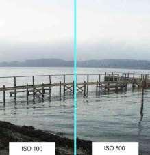
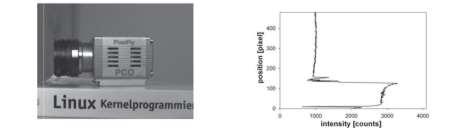
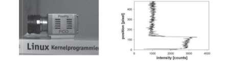
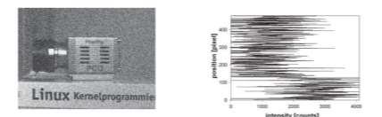
7 Pixel size and noise 7


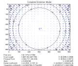
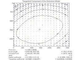
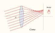
8 TIFF & JPG Lens problems - Geometric 8

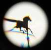
9 Lens problems - Radiometric Vignetting Camera calibration correction using analytical models 9


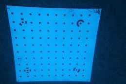
10 Where Around the AOI/object How to measure With a more accurate method At the coordinate system, that you wish to use and have your final results How many >>3 using a calibrated camera Limitation is your time and cost Targets or natural points Scale as an alternative When only shape needs to be recovered HOW Some notes about control points 10
11 HOW - S/W Web services 123dCatch Photosynth Arc3D Free Visual SFM Python Photogrammetric Toolbox MicMac Commercial Agisoft s Photoscan Capturing Reality Acute 3D Photomodeler Scanner iwitness Free Point cloud manipulation s/w: Meshlab, CloudCompare Lot s of open source s/w in HOW Output & products 11
12 Detail comparison 12

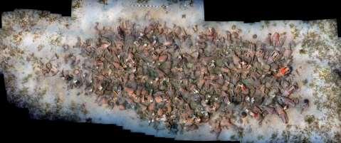
 Underwater measurements in Mazotos shipwreck in")


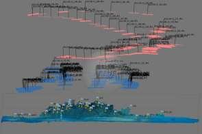
13 INTRO How we do it in Mazotos Tedious tape measurements: Error prone Currents nitrogen narcosis straight line Time consuming Small distances Limited information Cannot extract shape Each point in 3D requires >3 measurements) Underwater measurements in Mazotos shipwreck in Data acquisition Several aspects to consider Underwater photography Color, flashes, etc Light absorption (far objects invisible) Photogrammetry aspects Control points Block geometry Accuracy and pixel size Coverage (the whole AOI & adequate overlap) S/W aspects Automated on nor processes Computer power/speed & memory limitations Skills necessary (diving, uw photography, photogrammetry) 13


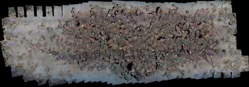
14 Data acquisition in strips Data acquisition in strips 14


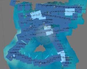
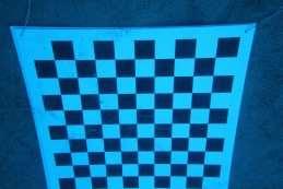
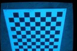
15 Alignment wt camera self calibration (Relative orientation) Alignment wt camera self calibration (Relative orientation) 15

 Perform optimization Final calibration of camera PC")
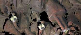
16 Photo measuring the control points Insert list of coordinates Locate and measure at least three points on photos The rest are back-projected to photos automatically Manually refine suggested locations Add scale bars (if existing) Perform optimization Final calibration of camera PC generation 16

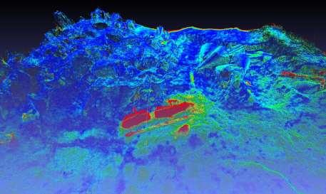
17 Solids (mesh, TIN of PC) PC comparisons 17

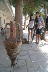
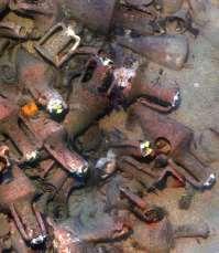
18 Finds 3D modelling (2010) 18


19 Amphora 3D model Measurements based on 3D models Basic dimensions Sections Alignment checking Volumetric checks 19

20 HANDS ON EXPERIENCE Photo set of photos (Strip) GoPro photos Control points Sketch of control points Coordinates of control points 20
COMPARISON OF LASER SCANNING, PHOTOGRAMMETRY AND SfM-MVS PIPELINE APPLIED IN STRUCTURES AND ARTIFICIAL SURFACES
 COMPARISON OF LASER SCANNING, PHOTOGRAMMETRY AND SfM-MVS PIPELINE APPLIED IN STRUCTURES AND ARTIFICIAL SURFACES 2012 ISPRS Melbourne, Com III/4, S.Kiparissi Cyprus University of Technology 1 / 28 Structure
APPLICATIONS OF OPEN AND FREE SOFTWARE: FROM UNDERWATER TO THE SKY
 APPLICATIONS OF OPEN AND FREE SOFTWARE: FROM UNDERWATER TO THE SKY ISPRS Working Group V/2 Conference, Cultural heritage data acquisition and processing 17th 19th August 2011 - University of York, UK Why
Cultural Heritage. Geometric Recording of Cultural Monuments. Basic Principles of Geometric Recording. Specific requirements
 LOW COST DIGITAL PHOTOGRAMMETRIC TECHNIQUES FOR THE DOCUMENTATION OF CULTURAL HERITAGE Ch. Ioannidis, S. Soile, C. Potsiou Lab. of Photogrammetry School of Rural & Surveying Eng. National Technical University
PART A Three-Dimensional Measurement with iwitness
 PART A Three-Dimensional Measurement with iwitness A1. The Basic Process The iwitness software system enables a user to convert two-dimensional (2D) coordinate (x,y) information of feature points on an
Photogrammetry for forest inventory.
 Photogrammetry for forest inventory. Marc Pierrot Deseilligny. IGN/ENSG, France. Jonathan Lisein. Ulg Gembloux Agro-Bio Tech, Belgium. 1- Photogrammetry 2- Application to forestry 3- Tools and proposed
3D recording of archaeological excavation
 5 th International Conference Remote Sensing in Archaeology The Age of Sensing 13-15 October 2014 - Duke University 3D recording of archaeological excavation Stefano Campana UNIVERSITY of CAMBRIDGE Faculty
TERRESTRIAL LASER SCANNER DATA PROCESSING
 TERRESTRIAL LASER SCANNER DATA PROCESSING L. Bornaz (*), F. Rinaudo (*) (*) Politecnico di Torino - Dipartimento di Georisorse e Territorio C.so Duca degli Abruzzi, 24 10129 Torino Tel. +39.011.564.7687
Comparing Aerial Photogrammetry and 3D Laser Scanning Methods for Creating 3D Models of Complex Objects
 Comparing Aerial Photogrammetry and 3D Laser Scanning Methods for Creating 3D Models of Complex Objects A Bentley Systems White Paper Cyril Novel Senior Software Engineer, Bentley Systems Renaud Keriven
Comparing Aerial Photogrammetry and 3D Laser Scanning Methods for Creating 3D Models of Complex Objects
 www.bentley.com Comparing Aerial Photogrammetry and 3D Laser Scanning Methods for Creating 3D Models of Complex Objects A Bentley White Paper Cyril Novel Senior Software Engineer, Bentley Systems Renaud
Centre for Digital Image Measurement and Analysis, School of Engineering, City University, Northampton Square, London, ECIV OHB
 HIGH ACCURACY 3-D MEASUREMENT USING MULTIPLE CAMERA VIEWS T.A. Clarke, T.J. Ellis, & S. Robson. High accuracy measurement of industrially produced objects is becoming increasingly important. The techniques
Exterior Orientation Parameters
 Exterior Orientation Parameters PERS 12/2001 pp 1321-1332 Karsten Jacobsen, Institute for Photogrammetry and GeoInformation, University of Hannover, Germany The georeference of any photogrammetric product
GIS Data Collection. This chapter reviews the main methods of GIS data capture and transfer and introduces key practical management issues.
 9 GIS Data Collection OVERVIEW This chapter reviews the main methods of GIS data capture and transfer and introduces key practical management issues. It distinguishes between primary (direct measurement)
Multiview Photogrammetry 3D Virtual Geology for everyone
 Multiview Photogrammetry 3D Virtual Geology for everyone A short course Marko Vrabec University of Ljubljana, Department of Geology FIRST: some background info Precarious structural measurements of fractures
Grafica 3D per i beni culturali: Dense stereo matching, alternative e processing finale del modello (+ extra) Lezione 14: 9 maggio 2013
 Lezione 14: 9 maggio 2013") Grafica 3D per i beni culturali: Dense stereo matching, alternative e processing finale del modello (+ extra) Lezione 14: 9 maggio 2013 0 Image-based 3D Reconstruction Advantages: Automatic Fast (relatively
Grafica 3D per i beni culturali: Dense stereo matching, alternative e processing finale del modello (+ extra) Lezione 14: 9 maggio 2013 0 Image-based 3D Reconstruction Advantages: Automatic Fast (relatively
Trimble Engineering & Construction Group, 5475 Kellenburger Road, Dayton, OH , USA
 Trimble VISION Ken Joyce Martin Koehler Michael Vogel Trimble Engineering and Construction Group Westminster, Colorado, USA April 2012 Trimble Engineering & Construction Group, 5475 Kellenburger Road,
Photogrammetry: DTM Extraction & Editing
 Photogrammetry: DTM Extraction & Editing How can one determine the x, y, and z of a location? Approaches to DTM Extraction Ground surveying Digitized topographic maps Traditional photogrammetry Hardcopy
TERRESTRIAL AND NUMERICAL PHOTOGRAMMETRY 1. MID -TERM EXAM Question 4
 TERRESTRIAL AND NUMERICAL PHOTOGRAMMETRY 1. MID -TERM EXAM Question 4 23 November 2001 Two-camera stations are located at the ends of a base, which are 191.46m long, measured horizontally. Photographs
Tecnologie per la ricostruzione di modelli 3D da immagini. Marco Callieri ISTI-CNR, Pisa, Italy
 Tecnologie per la ricostruzione di modelli 3D da immagini Marco Callieri ISTI-CNR, Pisa, Italy Who am I? Marco Callieri PhD in computer science Always had the like for 3D graphics... Researcher at the
Image-Based Modeling and Rendering. Image-Based Modeling and Rendering. Final projects IBMR. What we have learnt so far. What IBMR is about
 Image-Based Modeling and Rendering Image-Based Modeling and Rendering MIT EECS 6.837 Frédo Durand and Seth Teller 1 Some slides courtesy of Leonard McMillan, Wojciech Matusik, Byong Mok Oh, Max Chen 2
3GSM GmbH. Plüddemanngasse 77 A-8010 Graz, Austria Tel Fax:
 White Paper Graz, April 2014 3GSM GmbH Plüddemanngasse 77 A-8010 Graz, Austria Tel. +43-316-464744 Fax: +43-316-464744-11 office@3gsm.at www.3gsm.at Measurement and assessment of rock and terrain surfaces
3D from Images - Assisted Modeling, Photogrammetry. Marco Callieri ISTI-CNR, Pisa, Italy
 3D from Images - Assisted Modeling, Photogrammetry Marco Callieri ISTI-CNR, Pisa, Italy 3D from Photos Our not-so-secret dream: obtain a reliable and precise 3D from simple photos Why? Easier, cheaper
Tecnologie per la ricostruzione di modelli 3D da immagini. Marco Callieri ISTI-CNR, Pisa, Italy
 Tecnologie per la ricostruzione di modelli 3D da immagini Marco Callieri ISTI-CNR, Pisa, Italy 3D from Photos Our not-so-secret dream: obtain a reliable and precise 3D from simple photos Why? Easier, less
Grafica 3D per i beni culturali: Multiview stereo matching, making the model. Lezione 16: 5 maggio 2013
 Grafica 3D per i beni culturali: Multiview stereo matching, making the model Lezione 16: 5 maggio 2013 0 Image-based 3D Reconstruction Advantages: Automatic Fast (relatively to manual built) Good scalability
Integrating the Generations, FIG Working Week 2008,Stockholm, Sweden June 2008
 H. Murat Yilmaz, Aksaray University,Turkey Omer Mutluoglu, Selçuk University, Turkey Murat Yakar, Selçuk University,Turkey Cutting and filling volume calculation are important issues in many engineering
Structure from Motion: High resolution DEMs at any scale using everyday equipment
 Structure from Motion: High resolution DEMs at any scale using everyday equipment Anders Damsgaard Last revision: May 20, 2014 Outline Photogrammetry Method Examples Summary Photogrammetry using SfM Production
A COMPARISON OF SPARSE AND DENSE POINT APPROACH TO PHOTOGRAMMETRIC 3D MODELING FOR STONE TEXTURED OBJECTS (CASE STUDY: ARCHEOLOGICAL SITES) ABSTRACT
 ABSTRACT") A COMPARISON OF SPARSE AND DENSE POINT APPROACH TO PHOTOGRAMMETRIC 3D MODELING FOR STONE TEXTURED OBJECTS (CASE STUDY: ARCHEOLOGICAL SITES) Arnadi D. Murtiyoso 1, Deni Suwardhi 2 1,2 Spatial Information
A COMPARISON OF SPARSE AND DENSE POINT APPROACH TO PHOTOGRAMMETRIC 3D MODELING FOR STONE TEXTURED OBJECTS (CASE STUDY: ARCHEOLOGICAL SITES) Arnadi D. Murtiyoso 1, Deni Suwardhi 2 1,2 Spatial Information
Humanoid Robotics. Projective Geometry, Homogeneous Coordinates. (brief introduction) Maren Bennewitz
 Maren Bennewitz") Humanoid Robotics Projective Geometry, Homogeneous Coordinates (brief introduction) Maren Bennewitz Motivation Cameras generate a projected image of the 3D world In Euclidian geometry, the math for describing
Humanoid Robotics Projective Geometry, Homogeneous Coordinates (brief introduction) Maren Bennewitz Motivation Cameras generate a projected image of the 3D world In Euclidian geometry, the math for describing
Calibration of IRS-1C PAN-camera
 Calibration of IRS-1C PAN-camera Karsten Jacobsen Institute for Photogrammetry and Engineering Surveys University of Hannover Germany Tel 0049 511 762 2485 Fax -2483 Email karsten@ipi.uni-hannover.de 1.
EinScan-Pro vs. EinScan-Pro+
 China s first OTC company in the 3D digitizing and printing industry(830978) EinScan-Pro vs. EinScan-Pro+ Copyright 2015-2016 Shining 3D. All rights reserved. Version: November 2017 EinScan-Pro & Pro+
3D Object Representations. COS 526, Fall 2016 Princeton University
 3D Object Representations COS 526, Fall 2016 Princeton University 3D Object Representations How do we... Represent 3D objects in a computer? Acquire computer representations of 3D objects? Manipulate computer
Introduction to Computer Vision. Introduction CMPSCI 591A/691A CMPSCI 570/670. Image Formation
 Introduction CMPSCI 591A/691A CMPSCI 570/670 Image Formation Lecture Outline Light and Optics Pinhole camera model Perspective projection Thin lens model Fundamental equation Distortion: spherical & chromatic
Computer Vision. Introduction
 Computer Vision Introduction Filippo Bergamasco (filippo.bergamasco@unive.it) http://www.dais.unive.it/~bergamasco DAIS, Ca Foscari University of Venice Academic year 2016/2017 About this course Official
Improving Initial Estimations for Structure from Motion Methods
 Improving Initial Estimations for Structure from Motion Methods University of Bonn Outline Motivation Computer-Vision Basics Stereo Vision Bundle Adjustment Feature Matching Global Initial Estimation Component
Analytical and Computer Cartography Winter Lecture 14: Three Dimensional Mapping and Modeling
 Analytical and Computer Cartography Winter 2017 Lecture 14: Three Dimensional Mapping and Modeling 3D measurement systems: remote sensing of objects First generation DEMs, photogrammetry and contour conversion
FAST REGISTRATION OF TERRESTRIAL LIDAR POINT CLOUD AND SEQUENCE IMAGES
 FAST REGISTRATION OF TERRESTRIAL LIDAR POINT CLOUD AND SEQUENCE IMAGES Jie Shao a, Wuming Zhang a, Yaqiao Zhu b, Aojie Shen a a State Key Laboratory of Remote Sensing Science, Institute of Remote Sensing
High-Fidelity Augmented Reality Interactions Hrvoje Benko Researcher, MSR Redmond
 High-Fidelity Augmented Reality Interactions Hrvoje Benko Researcher, MSR Redmond New generation of interfaces Instead of interacting through indirect input devices (mice and keyboard), the user is interacting
STARTING WITH DRONES. Data Collection and Remote Sensing with UAVs, etc. Dr. Bill Hazelton LS
 STARTING WITH DRONES Data Collection and Remote Sensing with UAVs, etc. Dr. Bill Hazelton LS What this Talk is About UAV-based data acquisition: What you need to get involved Processes in getting spatial
Chapters 1 7: Overview
 Chapters 1 7: Overview Chapter 1: Introduction Chapters 2 4: Data acquisition Chapters 5 7: Data manipulation Chapter 5: Vertical imagery Chapter 6: Image coordinate measurements and refinements Chapter
High Definition Modeling of Calw, Badstrasse and its Google Earth Integration
 Master Thesis Yuanting LI High Definition Modeling of Calw, Badstrasse and its Google Earth Integration Duration of the Thesis: 6 months Completion: July, 2014 Supervisors: Prof.Dr.-Ing.Dieter Fritsch
Agisoft PhotoScan Tutorial
 Agisoft PhotoScan Tutorial Agisoft PhotoScan is a photogrammetry software that allows you to build 3D models from digital photographs. Photogrammetry requires a series of photographs of an object from
ABSTRACT 1. INTRODUCTION
 Published in SPIE Proceedings, Vol.3084, 1997, p 336-343 Computer 3-d site model generation based on aerial images Sergei Y. Zheltov, Yuri B. Blokhinov, Alexander A. Stepanov, Sergei V. Skryabin, Alexander
GABRIELE GUIDI, PHD POLITECNICO DI MILANO, ITALY VISITING SCHOLAR AT INDIANA UNIVERSITY NOV OCT D IMAGE FUSION
 GABRIELE GUIDI, PHD POLITECNICO DI MILANO, ITALY VISITING SCHOLAR AT INDIANA UNIVERSITY NOV 2017 - OCT 2018 3D IMAGE FUSION 3D IMAGE FUSION WHAT A 3D IMAGE IS? A cloud of 3D points collected from a 3D
Image Transformations & Camera Calibration. Mašinska vizija, 2018.
 Image Transformations & Camera Calibration Mašinska vizija, 2018. Image transformations What ve we learnt so far? Example 1 resize and rotate Open warp_affine_template.cpp Perform simple resize
Structured light 3D reconstruction
 Structured light 3D reconstruction Reconstruction pipeline and industrial applications rodola@dsi.unive.it 11/05/2010 3D Reconstruction 3D reconstruction is the process of capturing the shape and appearance
LEARNING KIT AND TUTORIALS FOR THE DIFFUSION OF THE DIGITAL PHOTOGRAMMETRY
 LEARNING KIT AND TUTORIALS FOR THE DIFFUSION OF THE DIGITAL PHOTOGRAMMETRY Elena ALBERY *, Andrea LINGUA *, Paolo MASCHIO * * Politecnico di Torino, Italia Dipartimento di Georisorse e Territorio Albery@vdiget.polito.it,
FOUR-BAND THERMAL MOSAICKING: A NEW METHOD TO PROCESS THERMAL IMAGERY FROM UAV FLIGHT YICHEN YANG YALE SCHOOL OF FORESTRY AND ENVIRONMENTAL STUDIES
 FOUR-BAND THERMAL MOSAICKING: A NEW METHOD TO PROCESS THERMAL IMAGERY FROM UAV FLIGHT YICHEN YANG YALE SCHOOL OF FORESTRY AND ENVIRONMENTAL STUDIES OUTLINE Background Objectives Methodology Results Calibration
COSC579: Scene Geometry. Jeremy Bolton, PhD Assistant Teaching Professor
 COSC579: Scene Geometry Jeremy Bolton, PhD Assistant Teaching Professor Overview Linear Algebra Review Homogeneous vs non-homogeneous representations Projections and Transformations Scene Geometry The
ANALYSIS OF KOREAN MEGALITHIC BUDDHA USING PHOTOGRAMMETRIC AND LASER SCANNING SYSTEM
 ANALYSIS OF KOREAN MEGALITHIC BUDDHA USING PHOTOGRAMMETRIC AND LASER SCANNING SYSTEM Yeu, Bock-Mo*, Kim, Gi-Hong*, Sohn, Duk-Jae**, Kim, Wondae*** * Yonsei University, Korea Dept. of Civil Engineering,
CSE 4392/5369. Dr. Gian Luca Mariottini, Ph.D.
 University of Texas at Arlington CSE 4392/5369 Introduction to Vision Sensing Dr. Gian Luca Mariottini, Ph.D. Department of Computer Science and Engineering University of Texas at Arlington WEB : http://ranger.uta.edu/~gianluca
Processing to Create a 3D Model
 3D Modelling Processing to Create a 3D Model These guidance notes take you through how to process multiple photographs of a rock art panel to create a 3D model. In order to do this, you first need to capture
Tutorial (Beginner level): Orthomosaic and DEM Generation with Agisoft PhotoScan Pro 1.3 (with Ground Control Points)
: Orthomosaic and DEM Generation with Agisoft PhotoScan Pro 1.3 (with Ground Control Points)") Tutorial (Beginner level): Orthomosaic and DEM Generation with Agisoft PhotoScan Pro 1.3 (with Ground Control Points) Overview Agisoft PhotoScan Professional allows to generate georeferenced dense point
Tutorial (Beginner level): Orthomosaic and DEM Generation with Agisoft PhotoScan Pro 1.3 (with Ground Control Points) Overview Agisoft PhotoScan Professional allows to generate georeferenced dense point
Fusion of laser scanning and Photogrammetric data for the documentation and VR visualization of an archaeological tomb complex
 Presented at the FIG Congress 2018, May 6-11, 2018 in Istanbul, Turkey Fusion of laser scanning and Photogrammetric data for the documentation and VR visualization of an archaeological tomb complex E.
Tutorial (Beginner level): Orthomosaic and DEM Generation with Agisoft PhotoScan Pro 1.3 (without Ground Control Points)
: Orthomosaic and DEM Generation with Agisoft PhotoScan Pro 1.3 (without Ground Control Points)") Tutorial (Beginner level): Orthomosaic and DEM Generation with Agisoft PhotoScan Pro 1.3 (without Ground Control Points) Overview Agisoft PhotoScan Professional allows to generate georeferenced dense point
Tutorial (Beginner level): Orthomosaic and DEM Generation with Agisoft PhotoScan Pro 1.3 (without Ground Control Points) Overview Agisoft PhotoScan Professional allows to generate georeferenced dense point
COMPUTER VISION. Dr. Sukhendu Das Deptt. of Computer Science and Engg., IIT Madras, Chennai
 COMPUTER VISION Dr. Sukhendu Das Deptt. of Computer Science and Engg., IIT Madras, Chennai 600036. Email: sdas@iitm.ac.in URL: //www.cs.iitm.ernet.in/~sdas 1 INTRODUCTION 2 Human Vision System (HVS) Vs.
Computer and Machine Vision
 Computer and Machine Vision Lecture Week 12 Part-2 Additional 3D Scene Considerations March 29, 2014 Sam Siewert Outline of Week 12 Computer Vision APIs and Languages Alternatives to C++ and OpenCV API
P1: OTA/XYZ P2: ABC c01 JWBK288-Cyganek December 5, :11 Printer Name: Yet to Come. Part I COPYRIGHTED MATERIAL
 Part I COPYRIGHTED MATERIAL 1 Introduction The purpose of this text on stereo-based imaging is twofold: it is to give students of computer vision a thorough grounding in the image analysis and projective
AIRPHEN. The Multispectral camera from HIPHEN
 AIRPHEN The Multispectral camera from HIPHEN AIRPHEN is a multispectral scientific camera developed by agronomists and photonics engineers to match plant measurements needs and constraints. Its high flexibility,
Computer Vision Projective Geometry and Calibration. Pinhole cameras
 Computer Vision Projective Geometry and Calibration Professor Hager http://www.cs.jhu.edu/~hager Jason Corso http://www.cs.jhu.edu/~jcorso. Pinhole cameras Abstract camera model - box with a small hole
3D MODELING OF CLOSE-RANGE OBJECTS: PHOTOGRAMMETRY OR LASER SCANNING?
 3D MODELING OF CLOSE-RANGE OBJECTS: PHOTOGRAMMETRY OR LASER SCANNING? F. Remondino 1 A. Guarnieri 2 A. Vettore 2 1 Institute of Geodesy and Photogrammetry ETH Hönggerberg - Zurich, Switzerland e-mail:
Tutorial (Intermediate level): 3D Model Reconstruction of the building with Agisoft PhotoScan 1.0.0
: 3D Model Reconstruction of the building with Agisoft PhotoScan 1.0.0") Tutorial (Intermediate level): 3D Model Reconstruction of the building with Agisoft PhotoScan 1.0.0 Add Photos To add photos select Add Photos... command from the Workflow menu or click Add Photos button
Tutorial (Intermediate level): 3D Model Reconstruction of the building with Agisoft PhotoScan 1.0.0 Add Photos To add photos select Add Photos... command from the Workflow menu or click Add Photos button
An Evaluation of Volumetric Interest Points
 An Evaluation of Volumetric Interest Points Tsz-Ho YU Oliver WOODFORD Roberto CIPOLLA Machine Intelligence Lab Department of Engineering, University of Cambridge About this project We conducted the first
SIMPLE ROOM SHAPE MODELING WITH SPARSE 3D POINT INFORMATION USING PHOTOGRAMMETRY AND APPLICATION SOFTWARE
 SIMPLE ROOM SHAPE MODELING WITH SPARSE 3D POINT INFORMATION USING PHOTOGRAMMETRY AND APPLICATION SOFTWARE S. Hirose R&D Center, TOPCON CORPORATION, 75-1, Hasunuma-cho, Itabashi-ku, Tokyo, Japan Commission
Measurements using three-dimensional product imaging
 ARCHIVES of FOUNDRY ENGINEERING Published quarterly as the organ of the Foundry Commission of the Polish Academy of Sciences ISSN (1897-3310) Volume 10 Special Issue 3/2010 41 46 7/3 Measurements using
Available online at ScienceDirect. Procedia Environmental Sciences 36 (2016 )
") Available online at www.sciencedirect.com ScienceDirect Procedia Environmental Sciences 36 (2016 ) 184 190 International Conference on Geographies of Health and Living in Cities: Making Cities Healthy
Available online at www.sciencedirect.com ScienceDirect Procedia Environmental Sciences 36 (2016 ) 184 190 International Conference on Geographies of Health and Living in Cities: Making Cities Healthy
123D Catch - Tutorial
 123D Catch - Tutorial Autodesk s 123D Catch software (formerly Project Photofly) is based on photogrammetry. Photogrammetry is a process which derives geometric properties of an object from a series of
EVOLUTION OF POINT CLOUD
 Figure 1: Left and right images of a stereo pair and the disparity map (right) showing the differences of each pixel in the right and left image. (source: https://stackoverflow.com/questions/17607312/difference-between-disparity-map-and-disparity-image-in-stereo-matching)
Sasanka Madawalagama Geoinformatics Center Asian Institute of Technology Thailand
 Sasanka Madawalagama Geoinformatics Center Asian Institute of Technology Thailand This learning material was not prepared by ADB. The views expressed in this document are the views of the author/s and
Understanding Variability
 Understanding Variability Why so different? Light and Optics Pinhole camera model Perspective projection Thin lens model Fundamental equation Distortion: spherical & chromatic aberration, radial distortion
BE INSPIRED.
 BE INSPIRED www.scaninabox.com Last update October 2017 PROFESSIONALISM, OUR CORE Accurately manufactured in every detail, Scan in a Box FX offers high quality 3D Scans. The Made in Italy design has been
Accurate 3D Face and Body Modeling from a Single Fixed Kinect
 Accurate 3D Face and Body Modeling from a Single Fixed Kinect Ruizhe Wang*, Matthias Hernandez*, Jongmoo Choi, Gérard Medioni Computer Vision Lab, IRIS University of Southern California Abstract In this
Compact Manual Camera Digital Best Zoom And Low Light Wide Angle
 Compact Manual Camera Digital Best Zoom And Low Light Wide Angle 10 best compact cameras of 2015 / Whether you're an expert, novice, sports though technically it's any digital camera with a non-removable
Il colore: acquisizione e visualizzazione. Lezione 17: 11 Maggio 2012
 Il colore: acquisizione e visualizzazione Lezione 17: 11 Maggio 2012 The importance of color information Precision vs. Perception 3D scanned geometry Photo Color and appearance Pure geometry Pure color
Mini Course Archaeological Sciences Interdisciplinary Group University of Minnesota 1
 Mini Course Archaeological Sciences Interdisciplinary Group University of Minnesota 1 Introduction What is photogrammetry, how does it work, what materials does it work on, and how does it compare to other
Chapters 1 5. Photogrammetry: Definition, introduction, and applications. Electro-magnetic radiation Optics Film development and digital cameras
 Chapters 1 5 Chapter 1: Photogrammetry: Definition, introduction, and applications Chapters 2 4: Electro-magnetic radiation Optics Film development and digital cameras Chapter 5: Vertical imagery: Definitions,
Chapters 1 9: Overview
 Chapters 1 9: Overview Chapter 1: Introduction Chapters 2 4: Data acquisition Chapters 5 9: Data manipulation Chapter 5: Vertical imagery Chapter 6: Image coordinate measurements and refinements Chapters
Identification Of the Main 3D Scanning Techniques Suitable for Use in Cultural Heritage Objects
 Identification Of the Main 3D Scanning Techniques Suitable for Use in Cultural Heritage Objects Tobias Reich i3mainz, Institute for Spatial Information and Surveying Technology University of Applied Sciences
ENGN D Photography / Spring 2018 / SYLLABUS
 ENGN 2502 3D Photography / Spring 2018 / SYLLABUS Description of the proposed course Over the last decade digital photography has entered the mainstream with inexpensive, miniaturized cameras routinely
A Guide to Processing Photos into 3D Models Using Agisoft PhotoScan
 A Guide to Processing Photos into 3D Models Using Agisoft PhotoScan Samantha T. Porter University of Minnesota, Twin Cities Fall 2015 Index 1) Automatically masking a black background / Importing Images.
DERIVING PEDESTRIAN POSITIONS FROM UNCALIBRATED VIDEOS
 DERIVING PEDESTRIAN POSITIONS FROM UNCALIBRATED VIDEOS Zoltan Koppanyi, Post-Doctoral Researcher Charles K. Toth, Research Professor The Ohio State University 2046 Neil Ave Mall, Bolz Hall Columbus, OH,
All human beings desire to know. [...] sight, more than any other senses, gives us knowledge of things and clarifies many differences among them.
![All human beings desire to know. [...] sight, more than any other senses, gives us knowledge of things and clarifies many differences among them.](/thumbs/91/106597332.jpg "All human beings desire to know. [...] sight, more than any other senses, gives us knowledge of things and clarifies many differences among them.") All human beings desire to know. [...] sight, more than any other senses, gives us knowledge of things and clarifies many differences among them. - Aristotle University of Texas at Arlington Introduction
All human beings desire to know. [...] sight, more than any other senses, gives us knowledge of things and clarifies many differences among them. - Aristotle University of Texas at Arlington Introduction
Chapters 1 5. Photogrammetry: Definition, introduction, and applications. Electro-magnetic radiation Optics Film development and digital cameras
 Chapters 1 5 Chapter 1: Photogrammetry: Definition, introduction, and applications Chapters 2 4: Electro-magnetic radiation Optics Film development and digital cameras Chapter 5: Vertical imagery: Definitions,
Using Web Camera Technology to Monitor Steel Construction
 Using Web Camera Technology to Monitor Steel Construction Kerry T. Slattery, Ph.D., P.E. Southern Illinois University Edwardsville Edwardsville, Illinois Many construction companies install electronic
Photogrammetry: A Modern Tool for Crash Scene Mapping
 Photogrammetry: A Modern Tool for Crash Scene Mapping Background A police accident investigator (AI) has many tasks when arriving at a crash scene. The officer s highest priority is public safety; the
XXV FIG International Congress KUALA LUMPUR Highly Detailed 3D Modelling of Mayan Cultural Heritage using an UAV
 XXV FIG International Congress KUALA LUMPUR 2014 Highly Detailed 3D Modelling of Mayan Cultural Heritage using an UAV Cornelis Stal, Britt Lonneville, Timothy Nuttens, Philippe De Maeyer, Alain De Wulf
CAPTURING REALITY AT CENTRE BLOCK
 CAPTURING REALITY AT CENTRE BLOCK C. Boulanger a, C. Ouimet a, N. Yeomans a a Heritage Conservation Services, Public Services and Procurement Canada, 30 Victoria St, Gatineau, Quebec KEY WORDS: Structure
Unwrapping of Urban Surface Models
 Unwrapping of Urban Surface Models Generation of virtual city models using laser altimetry and 2D GIS Abstract In this paper we present an approach for the geometric reconstruction of urban areas. It is
Data Acquisition, Leica Scan Station 2, Park Avenue and 70 th Street, NY
 Automated registration of 3D-range with 2D-color images: an overview 44 th Annual Conference on Information Sciences and Systems Invited Session: 3D Data Acquisition and Analysis March 19 th 2010 Ioannis
Digital Preservation of the Aurelius Church and the Hirsau Museum Complex by Means of HDS and Photogrammetric Texture Mapping
 Master Thesis Ruxandra MOROSAN Ruxandra MOROSAN Digital Preservation of the Aurelius Church and the Hirsau Museum Complex by Means of HDS and Photogrammetric Texture Mapping Duration of the Thesis: 6 months
Technical Focus. DIGITAL PRODUCTION CHALLENGE 2011 Thursday 24 to Saturday 26 November 2011, Oslo
 DIGITAL PRODUCTION CHALLENGE 2011 Thursday 24 to Saturday 26 November 2011, Oslo Technical Focus By Philippe Ros Director of photography, AFC Digital Imaging Supervisor www.philipperos.com Technical Focus
Geometric camera models and calibration
 Geometric camera models and calibration http://graphics.cs.cmu.edu/courses/15-463 15-463, 15-663, 15-862 Computational Photography Fall 2018, Lecture 13 Course announcements Homework 3 is out. - Due October
ADVANCING REALITY MODELING WITH CONTEXTCAPTURE
 ADVANCING REALITY MODELING WITH CONTEXTCAPTURE Knowing the existing conditions of a project is a key asset in any decision process. Governments need to better know their territories, through mapping operations,
Just some thoughts about cameras. Please contact me if you have any questions.
 Just some thoughts about cameras Please contact me if you have any questions. leah.rachlis@asd20.org Every student will need to have a camera to use for Digital Photography Class. It does not need to be
USE THE 3D LASER SCANNING FOR DOCUMENTATION THE RIGA CATHEDRAL IN LATVIA
 USE THE 3D LASER SCANNING FOR DOCUMENTATION THE RIGA CATHEDRAL IN LATVIA Maris Kalinka, Elina Rutkovska, Department of Geomatic, Riga Technical University, Azenes 16-109, Riga, Latvia, geomatika@geomatika.lv
Characterizing Strategies of Fixing Full Scale Models in Construction Photogrammetric Surveying. Ryan Hough and Fei Dai
 697 Characterizing Strategies of Fixing Full Scale Models in Construction Photogrammetric Surveying Ryan Hough and Fei Dai West Virginia University, Department of Civil and Environmental Engineering, P.O.
International Journal of Civil Engineering and Geo-Environment. Close-Range Photogrammetry For Landslide Monitoring
 International Journal of Civil Engineering and Geo-Environment Journal homepage:http://ijceg.ump.edu.my ISSN:21802742 Close-Range Photogrammetry For Landslide Monitoring Munirah Bt Radin Mohd Mokhtar,
APPROACH TO ACCURATE PHOTOREALISTIC MODEL GENERATION FOR COMPLEX 3D OBJECTS
 Knyaz, Vladimir APPROACH TO ACCURATE PHOTOREALISTIC MODEL GENERATION FOR COMPLEX 3D OBJECTS Vladimir A. Knyaz, Sergey Yu. Zheltov State Research Institute of Aviation System (GosNIIAS), Victorenko str.,
3D documenatation of the petalaindera: digital heritage preservation methods using 3D laser scanner and photogrammetry
 IOP Conference Series: Materials Science and Engineering PAPER OPEN ACCESS 3D documenatation of the petalaindera: digital heritage preservation methods using 3D laser scanner and photogrammetry To cite
I N T R O D U C T I O N T O C O M P U T E R G R A P H I C S
 3D Viewing: the Synthetic Camera Programmer s reference model for specifying 3D view projection parameters to the computer General synthetic camera (e.g., PHIGS Camera, Computer Graphics: Principles and
3D Models from Range Sensors. Gianpaolo Palma
 3D Models from Range Sensors Gianpaolo Palma Who Gianpaolo Palma Researcher at Visual Computing Laboratory (ISTI-CNR) Expertise: 3D scanning, Mesh Processing, Computer Graphics E-mail: gianpaolo.palma@isti.cnr.it
Announcements. Recognition (Part 3) Model-Based Vision. A Rough Recognition Spectrum. Pose consistency. Recognition by Hypothesize and Test
 Model-Based Vision. A Rough Recognition Spectrum. Pose consistency. Recognition by Hypothesize and Test") Announcements (Part 3) CSE 152 Lecture 16 Homework 3 is due today, 11:59 PM Homework 4 will be assigned today Due Sat, Jun 4, 11:59 PM Reading: Chapter 15: Learning to Classify Chapter 16: Classifying
Announcements (Part 3) CSE 152 Lecture 16 Homework 3 is due today, 11:59 PM Homework 4 will be assigned today Due Sat, Jun 4, 11:59 PM Reading: Chapter 15: Learning to Classify Chapter 16: Classifying