Leveraging Point Clouds to Produce Accurate As-Built Models. Sonia Delgadillo
|
|
|
- Elwin Green
- 6 years ago
- Views:
Transcription
1 Leveraging Point Clouds to Produce Accurate As-Built Models Sonia Delgadillo


2 Time What is CADWorx fieldpipe? Easy customization Comprehensive specs Short learning curve AutoCAD -based CADWorx Plant Design Suite 2 Overall Set-up
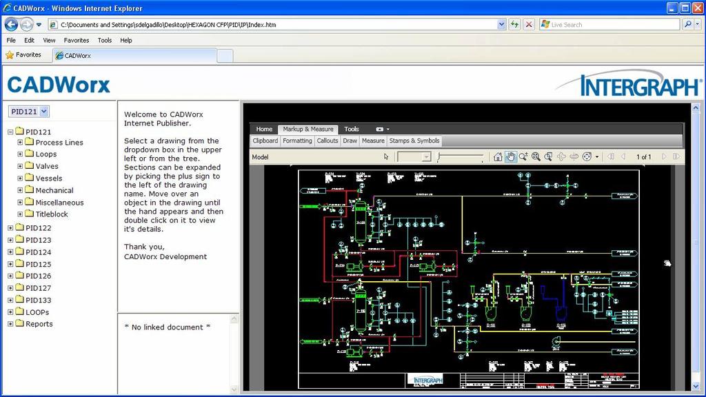
3 CADWorx Internet Publisher SCENARIO: Distributing intelligent P&ID information to stakeholders and data consumers


4 Design Collaboration CADWorx Internet Publisher Milestone Project Team Reviewed via Internet, Intranet or Extranet Issue Distribute Consistent distribution to all stakeholders Schedule 4
5 Distributing markups and updating P&IDs 5
6 CADWorx Plant Professional CADWorx fieldpipe SOLUTION (CADWorx + fieldpipe): Accurate as-builts and 3D models from laser scan or from surveying data


7 CADWorx Plant Professional Intelligent 3D Piping Design Specification-driven Design Steel and Equipment Ducting and Cable Trays Collision Checking ISOGEN Isometrics Live Database Links Model and P&ID Synchronization CADWorx Design Review included CADWorx P&ID Standard included Links to CAESAR II Stress Analysis 7

8 Traditional versus fieldpipe Traditional CADWorx fieldpipe Manual labour using manual measurement Capture of the as-built situation Laser Scanning or Laser Survey Not accurate Accuracy Very accurate Not safe Low Paper Safety Investment Deliverables Much safer Investment 10K 130K 3D model, Isometrics, Bill of Material 8


9 Project Hours Value Proposition Compress brownfield project schedules; reduce cost & risk; improve accuracy & quality of models and deliverables Quicker Highly accurate Automatic deliverables CAESAR II integration Compare design with as-built Traditional fieldpipe


10 Laser surveying Requirements Device & fieldpipe set-up Find diameter of pipe Find centre-line of pipe Find location pipe components AutoCAD CADWorx fieldpipe Leica CloudWorx 10
11 Laser surveying Requirements Device & fieldpipe set-up Find diameter of pipe Find centre-line of pipe Find location pipe components Line-number Piping specification Calibrate total station for fixed reference points 11

12 Laser surveying Requirements Device & fieldpipe set-up Find diameter of pipe Find centre-line of pipe Find location pipe components Diameter identified! 12
13 Laser surveying (Find centerline pipeline) Requirements Device & fieldpipe set-up Find diameter of pipe Find centre-line of pipe Find location pipe components Centerline identified! Centerline identified! 13

14 Laser surveying (Find pipe components) Requirements Device & fieldpipe set-up Find diameter of pipe Find centre-line of pipe Find location pipe components Flange location identified! 14
 CADWorx fieldpipe Leica CloudWorx Professional (Included) Leica Cyclone Navigator (Free)")
15 Laser scanning Requirements On-site laser scanning Off-site clean-up of point cloud Creation of intelligent 3D model AutoCAD CADWorx Plant Professional (included) CADWorx fieldpipe Leica CloudWorx Professional (Included) Leica Cyclone Navigator (Free) 15

16 Laser scanning Requirements On-site laser scanning Off-site clean-up of point cloud Creation of intelligent 3D model

17 Laser scanning Requirements On-site laser scanning Off-site clean-up of point cloud Creation of intelligent 3D model 17
18 Laser scanning Requirements On-site laser scanning Off-site clean-up of point cloud Creation of intelligent 3D model 18
19 Deliverables from laser scanning and laser surveying Material take-off s ISOGEN isometrics Clash detection Compare design with as-built CAESAR II interface 19
20 Deliverables from Laser scanning and laser surveying Material take-off s ISOGEN isometrics Clash detection Compare design with as-built CAESAR II interface 20


21 Deliverables from Laser scanning and laser surveying Material take-off s ISOGEN isometrics Clash detection Compare design with as-built CAESAR II interface 21

22 Deliverables from Laser scanning and laser surveying Material take-off s ISOGEN isometrics Clash detection Compare design with as-built CAESAR II interface 22

23 Deliverables from Laser scanning and laser surveying Material take-off s ISOGEN Isometrics Clash detection Compare design with as-built CAESAR II Interface 23
24 CADWorx Plant Professional CADWorx fieldpipe As building current piping system Adding new lines Intergraph Corp 2012

25 As build existing piping 25

26 Add new piping to as-build model 26
27 CAESAR II Linking between design and analysis Pipe Stress Analysis


28 Integration Between Design and Analysis CADWorx Analysis Fast transfers Fast transfers No remodelling No remodelling Higher accuracy Increased productivity Compliant design Reduced risk 28

29 Passing information between design and Analysis 29
30 Deliverables


31 Industry Standard Deliverables AutoCAD Semi-automatic GAs Flexible presentation Automatic isometrics ISOGEN Consistent presentation 31


32 Creating Automated Deliverables 32


33 Laser survey or laser scanning Laser survey Point to Point Capture of model Laser scanning Point Cloud Very accurate Best Accurate option Best Accuracy ~2-3mm option for for ~4-6mm large small projects projects involving small requiring a 3D 100% numbers in the of Location for 3D model Design of office many pipes, field or when modelling pipes and high accuracy other is 10-35K required Investment disciplines K 3D model, isometrics, bill of materials Deliverables 3D model, isometrics, bill of materials 33
34 Project Hours Value Proposition Compress brownfield project schedules; reduce cost & risk; improve accuracy & quality of models and deliverables Quicker Highly accurate Automatic deliverables CAESAR II integration Compare design with as-built Traditional fieldpipe

35 Takeaway If the scenario presented is your reality or of your contractors then you should be looking to CADWorx fieldpipe to help improve your productivity. Intergraph Corp 2012
COADE. CADWorx. Plant Design Suite
 COADE CADWorx Plant Design Suite CADWorx: The most complete plant design suite for the AutoCAD platform! CADWorx is COADE s integrated series of AutoCAD -based tools for plant design that provides intelligent
Most as-built information is still manually collected. Today s Design Market
 Agenda 1. Overview of 3D laser scanning 2. HDS 3D Laser scanning applications Leica ScanStation2 True Color Scan 3. Demonstration of HDS & Trueview 4. Questions and Answers The advanced 3D Laser Scanning
COADE. CADWorx. Plant Design Suite
 COADE CADWorx Plant Design Suite CADWorx: The most complete plant design suite for the AutoCAD platform! CADWorx is COADE s integrated series of AutoCAD -based tools for plant design that provides intelligent
Autodesk Plant Design Suite. Build on the power and familiarity of AutoCAD with multidiscipline plant design solutions.
 Autodesk Plant Design Suite Build on the power and familiarity of AutoCAD with multidiscipline plant design solutions. The Suite Advantage: Convenient, Comprehensive, Cost-Effective Autodesk Plant Design
Autodesk Plant Design Suite. Integrated solutions for plant design and whole-project review
 Autodesk Plant Design Suite Integrated solutions for plant design and whole-project review The Suite Advantage The suite combines AutoCAD, AutoCAD P&ID, AutoCAD Plant 3D, and Autodesk Navisworks software
 www.lfm-software.com LFM Software Overview Realise the true value of your laser scan data. Outside the EPC environment, Owner Operators are now also recognising the benefits of 3D laser scanning. Laser
OPEN. INTELLIGENT. Laser Scanning Software Solutions
 OPEN. INTELLIGENT. Laser Scanning Software Solutions www.lfm-software.com The Future of Laser Scanning Safe and efficient operation of complex engineering assets, and the efficient management of their
POINT CLOUD based REVERSE ENGINEERING. Young-Ho Chai, Ph.D
 POINT CLOUD based REVERSE ENGINEERING Young-Ho Chai, Ph.D 3D Spatial Survey Workflow Hardware Requirements Phase Based Laser Scanner: -Leica ScanStation P20 x 1EA -Usage: Short-range, ~80m Time of Flight
A Sweet Success in Plant Documentation for Michigan Sugar Company
 A Sweet Success in Plant Documentation for Michigan Sugar Company COMPANY LOCATION 3D Imaging Services Flint, MI TOOLS USED Leica ScanStation P40 (solutionshardware-p40.html) Leica Cyclone Software (solutionssoftware-cyclone.html)
ARECATECH SDN BHD CAPTURE THE REALITY IN TOUCH WITH TOMORROW
 CAPTURE THE REALITY IN TOUCH WITH TOMORROW ARECATECH SDN BHD 3D Laser Scanning Integrity and Management Services Detail Engineering Design Support & COMOS Intelligent P & ID Services SmartPlant - PDMS
Terrestrial LiDAR. Patrick Crawford. Harnessing the Power of Big Data for Asset and Facility Management WHITE PAPER SHAFER, KLINE & WARREN
 WHITE PAPER Terrestrial LiDAR Harnessing the Power of Big Data for Asset and Facility Management Patrick Crawford Team Leader, Geospatial Systems SHAFER, KLINE & WARREN Executive Summary Terrestrial LiDAR
Leica High-Definition Surveying Systems. Leica HDS3000. The Industry Standard for High-Definition Surveying
 Leica High-Definition Surveying Systems Leica HDS3000 The Industry Standard for High-Definition Surveying HDS High-Definition Surveying TM : Laser Scanning Redefined High-Definition Surveying, or HDS,
The Leica HDS Family. The Right Tool for the Job HDS3000 HDS2500 HDS4500. Cyclone & CloudWorx. Press the QuickScan button to define the field-of-view.
 HDS2500 High accuracy scanner, ideal for fixed or raised installations when leveled tripod mounting is not practical, or areas with less stringent field-of-view requirements. The Leica HDS Family Time-of-flight
Terrestrial 3D laser scanning Practical aspects
 Terrestrial 3D laser scanning Practical aspects ISPRS WG VI/5&SC Summer School 2007 by Gregor Bilban 3D laser scanning Benefits Lower data collection costs Reduction or elimination of re-visits More accurate
INTEROPERABILITY SUMMARY Leveraging 3D Designs & Data
 W H I T E P A P E R INTEROPERABILITY SUMMARY Leveraging 3D Designs & Data Referencing and Converting Existing External Data to and from Multiple Formats in Engineering and Construction Projects Contents
Leica Cyclone 5.4 Technical Specifications
 Leica Cyclone 5.4 Technical Specifications HDS Scanner control and operation Scan Scan Scan Register Model Survey Viewer Acquire and display image Acquire image at specified resolution (high, medium, low)
Laser Scanning. 3D Model is not existing and is required for: studies revamping maintenance HSE integration in another 3D model archiving
 Laser Scanning Laser Scanning Laser scanning is used whenever: 3D Model is not existing and is required for: studies revamping maintenance HSE integration in another 3D model archiving 2 Object acquisition
Extracting Plant Deliverables from AutoCAD Point Clouds
 Extracting Plant Deliverables from AutoCAD Point Clouds The webinar will begin shortly. You will hear silence until the webinar begins. Please note that this webinar is being recorded and all registrants
FARO As-Built for AutoCAD Software Versatile Reality to CAD Solutions
 FARO As-Built for AutoCAD Software Versatile Reality to CAD Solutions FARO As-Built for Autodesk Revit Creating Efficiencies in Scan Data Extraction for BIM FARO As-Built for AutoCAD Software TM Versatile
Engineering Systems Manager
 02/04/2006 1 Engineering Systems Manager Colin K Fairweather 02/04/2006 2 Point Cloud Data With PDMS On Brownfield Projects What are the benefits and why use the technology? 02/04/2006 3 The History of
Type of Project: Metric Mix Metric Inches. Project Standard: ANSI ANSI/ ISO ISO DIN
 3D Plant Project Setup Use this form to help you compile the various of information you need to design an effective, comprehensive, and correct 3D plant project. Date Prepared: Project Name: Project Location:
CADWorx DraftPro Questions and Answers
 CADWorx DraftPro Questions and Answers Use CADWorx DraftPro software to improve the quality, efficiency, safety and cost effectiveness of those served by plant design. Today, Intergraph CADWorx & Analysis
Laser Scanning & Creation of 3D Models For BIM and Process Facilities
 Specialised Surveying Solutions Presented to: ICES UAE Region Abu Dhabi November 2009 Land and Engineering Surveying Services 3D Laser Scanning & Modeling Laser Scanning Technology Zoller+Fröhlich Phase
Explore Laser Scanning in As-Built Survey. Vijay Chowdhary SE: BIM/CIM
 Explore Laser Scanning in As-Built Survey Vijay Chowdhary SE: BIM/CIM About FARO The world leader in portable 3-D measurement and imaging technology EMEA Headquarters Korntal-Münchingen, Germany APAC Headquarters
Displayed with permission The American Surveyor April/May Copyright 2009 Cheves Media
 NASA s Environmental Simulation Chamber A at the Johnson Space Center in Houston will require upgrades to accommodate testing of components for the new space telescopes. Laser scanning with the FARO LS
CloudWorx for Intergraph SmartPlant Review 1.0 Tutorial High-Definition Surveying. Tutorial-Plant
 Tutorial-Plant CloudWorx 1.0 for Intergraph SmartPlant Review CloudWorx for Intergraph SmartPlant Review provides a dynamic and flexible way to work efficiently with large as-built point clouds within
Is it possible to create User Defined Symbols (SKEY) for Isogen Isometric Drawings?
 for Isogen Isometric Drawings?") Chempute Software (Pty) Ltd P.O.Box 856, Kloof, 3640, South Africa Tel : Intl +27-31-7646840 Fax : Intl +27-31-7645934 Email :sales@chempute.com Question: How to Create User Isogen Symbols Using Symbols
Chempute Software (Pty) Ltd P.O.Box 856, Kloof, 3640, South Africa Tel : Intl +27-31-7646840 Fax : Intl +27-31-7645934 Email :sales@chempute.com Question: How to Create User Isogen Symbols Using Symbols
Realworks Software. A Powerful 3D Laser Scanning Office Software Suite
 TECHNICAL NOTES Realworks Software A Powerful 3D Laser Scanning Office Software Suite Trimble RealWorks is a powerful office software that imports rich data from your 3D laser scanning instrument and transforms
RealWorks Software. A Powerful 3D Laser Scanning Office Software Suite
 TECHNICAL NOTES RealWorks Software A Powerful 3D Laser Scanning Office Software Suite Trimble RealWorks is a powerful office software that imports rich data from your 3D laser scanning instrument and transforms
Why CAXpert? Use Cases to Consider
 Why CAXpert? Use Cases to Consider We ve highlighted some areas that offer significant benefits, along with customers who show that use case in action. See if any of these solve a problem for you. 2016-07-04
Leica ScanStation C10 The All-in-One Laser Scanner for Any Application
 The All-in-One Laser Scanner for Any Application Versatility, Productivity, Value Many organizations interested in laser scanning to diversify and/or improve current business have been waiting for a scanner
The Most Comprehensive Solution for Indoor Mapping Applications
 The Most Comprehensive Solution for Indoor Mapping Applications TRIMBLE INDOOR MOBILE MAPPING SOLUTION TRIMBLE INDOOR MOBILE MAPPING SOLUTION (TIMMS): HIGH EFFICIENCY, MAXIMUM FLEXIBILITY, ALL-IN-ONE PACKAGE
Simplicity is the new black: The BLK360 story
 Simplicity is the new black: The BLK360 story Vanda KADLECIKOVA Leica Geosystems Heerbrugg, Switzerland E-mail: vanda.kadlecikova@leica-geosystems.com Abstract Meet the game changer. The new Leica BLK360
aveva.com LASER FOCUSED How the use of laser scanning and 3D modelling is modernising shipyard operations WHITE PAPER September 2017
 aveva.com LASER FOCUSED How the use of laser scanning and 3D modelling is modernising shipyard operations WHITE PAPER September 2017 WHITE PAPER 2 TIME TO TRANSFORM Shipyards around the world are going
Trimble Connect Overview
 Trimble Connect Overview Trimble Connect reduces costs and improves efficiency for buildings and infrastructure projects. It does this by consolidating and seamlessly exchanging information throughout
Trimble Update. BIMnet 17 th June 2013 BUILDING CONSTRUCTION
 Trimble Update BIMnet 17 th June 2013 BUILDING CONSTRUCTION Agenda Introduction to Trimble What is Trimble BIM+Build? The benefits of BIM to Field Questions? 2 Trimble corporate roots Founded in 1978 Market
Converting Existing Piping Specs
 Converting Existing Piping Specs Ian Matthew Autodesk, Inc. PD4216: In this class, we will show you how to convert piping specs from other 3D products. This class will demonstrate how to efficiently use
BARMELCO ELECTRICAL PTY LTD CAPABILITY STATEMENT BARMELCO ELECTRICAL PTY LTD CAPABILITY STATEMENT 1
 BARMELCO ELECTRICAL PTY LTD CAPABILITY STATEMENT BARMELCO ELECTRICAL PTY LTD CAPABILITY STATEMENT 1 ABOUT US OUR ADVANTAGE Barmelco Electrical is a 100% Indigenous-owned and operated electrical contracting
Draper Aden VIRTUAL CONSTRUCTION DOCUMENT, DESIGN, AND BUILD IN 3D
 VIRTUAL CONSTRUCTION VIRTUAL CONSTRUCTION The design and construction environment has changed. While the goals of completing a project on time, within budget, and at the expected level of quality remain
General Software. Program (Software House) Function. Office Productivity. Office (Microsoft) PDF File Generation and Management
 Function. Office Productivity. Office (Microsoft) PDF File Generation and Management") Company Software General Software Office (Microsoft) Office Productivity Acrobat Professional (Adobe) Primavera P6 Professional R8.2 (Oracle) Microstation Ver.J, V8,XS and all versions (Bentley) Autocad
Company Software General Software Office (Microsoft) Office Productivity Acrobat Professional (Adobe) Primavera P6 Professional R8.2 (Oracle) Microstation Ver.J, V8,XS and all versions (Bentley) Autocad
Revit MEP. Autodesk Navisworks
 What is BIM? Autodesk BIM is an intelligent model-based process that helps owners and service providers achieve business results by enabling more accurate, accessible, and actionable insight throughout
Trimble Realworks Software
 TECHNICAL NOTES Trimble Realworks Software A Powerful 3D Laser Scanning Office Software Suite DESIGNED FOR TODAY S MULTIFACETED SCANNING PROFESSIONAL, TRIMBLE REALWORKS IS A POWERFUL OFFICE SOFTWARE THAT
Marc De Bruyne 3D Design Improvement Leader, DOW Chemical
 Marc De Bruyne 3D Design Improvement Leader, DOW Chemical John Foster Director, Profox Companies DOW Chemical Terneuzen in the Netherlands Globally, second largest DOW site after Freeport US. Producing
What s New CADWorx 2017
 What s New CADWorx 2017 Copyright Copyright 2003-2016 Intergraph Corporation. All Rights Reserved. Intergraph is part of Hexagon. Including software, file formats, and audiovisual displays; may be used
Geospatial Engineering Problems & Solutions Associated With NDP Roads, Tunnelling & Civil Engineering Projects Use of HDS Leica Laser Scanners
 Geospatial Engineering Problems & Solutions Associated With NDP Roads, Tunnelling & Civil Engineering Projects Use of HDS Leica Laser Scanners Laser Scanning Laser Scanning is a method of collecting large
Technical training May - August
 2017 Technical training May - August Register today! theppigroup.com/training Training centers located in Portland, OR & Seattle, WA. Why Train with PPI? PPI is the only locally owned and operated Autodesk
Available Services for Small Bore Connections (SBC)
") Evaluation of vibration induced fatigue failure on SBCs for new projects (design) or existing piping systems Vibration induced failures on Small Bore Connections (SBCs) are the most common integrity issues
Evaluation of vibration induced fatigue failure on SBCs for new projects (design) or existing piping systems Vibration induced failures on Small Bore Connections (SBCs) are the most common integrity issues
Innovation. lidarnews.com. volume 3 issue 5. Points clouds and terrain models support rail project. Structured light scanning for human head modeling
 volume 3 issue 5 LIDAR lidarnews.com SCALABILITY Points clouds and terrain models support rail project EXPRESSION Structured light scanning for human head modeling FLUCTUATION Scanning moving objects using
With FARO PointSense for Revit. Jörg Braunes Platform Owner Software Chris Palmer Sales Engineer 1
 From Point Clouds to BIM Models With FARO PointSense for Revit Jörg Braunes Platform Owner Software Chris Palmer Sales Engineer 1 Agenda Scan to BIM with Revit PointClouds in Revit Advanced Workflow with
BEFORE YOU BUY: SEVEN CRITICAL QUESTIONS TO ASK ABOUT LASER SCANNERS. Robert Gardiner
 BEFORE YOU BUY: SEVEN CRITICAL QUESTIONS TO ASK ABOUT LASER SCANNERS Robert Gardiner Table of Contents Introduction... 3 Horizontal and Vertical Angular Accuracies... 4 Movement Tracking... 6 Range Limitations...
Point Cloud Processing and Large Scalable Terrain Model Extraction Inga Morozoff
 Point Cloud Processing and Large Scalable Terrain Model Extraction Inga Morozoff 1 Point cloud data is a new data type that s being driven by the need for accurate 3D as-built information. Point cloud
technical notes trimble realworks software
 technical notes trimble realworks software A POWERFUL 3D LASER SCANNING OFFICE SOFTWARE SUITE Designed for today s multifaceted scanning professional, Trimble RealWorks is a powerful office software that
Industry 4.0 revolutionizing BIM and AEC
 CONFERÊNCIA CONSTRUÇÃO 4.0 O DESAFIO DA DIGITALIZAÇÃO DA CONSTRUÇÃO E A ENGENHARIA CIVIL NO CONTEXTO DA INDÚSTRIA 4.0 Industry 4.0 revolutionizing BIM and AEC Vakis P. Kokorelis Construsoft Portugal 22
WHY TRAIN WITH PPI? YOUR TECHNICAL HOME TEAM. CALL US TO LEARN MORE ABOUT GLOBAL E-TRAININGäS LIBRARY
 WHY TRAIN WITH PPI? PPI is the only locally owned and operated Autodesk reseller in Oregon and Western Washington! We have the largest Autodesk training centers in the Northwest! GLOBAL E-TRAINING IS THE
NEW APPROACH FOR SAFE, FAST AND ACCURATE SURVEY OF DEEP MINE SHAFTS
 NEW APPROACH FOR SAFE, FAST AND ACCURATE SURVEY OF DEEP MINE SHAFTS by Norbert Benecke & Peter Cain DMT GmbH &Co. KG, Germany / DMT Geosciences, Canada Kinemattic Shaft Survey 2013 Page 1 Who is DMT? is
Reality Capture: From Point Cloud To Design To Visualisation. by Shuaib Yunos, Baker Baynes
 Reality Capture: From Point Cloud To Design To Visualisation by Shuaib Yunos, Baker Baynes Perspective: Design & Construction Designers are conceiving buildings differently. Building owners expect a lot
ROHR2. Program System ROHR2 Interfaces - Overview and Details. SIGMA Ingenieurgesellschaft mbh
 ROHR2 Program System ROHR2 Interfaces - Overview and Details ROHR2 Interfaces Feature List Content ROHR2 Introduction... 1 1 ROHR2 interfaces... 1 1.1 ROHR2 Interfaces overview... 2 1.2 Licenses and system
3D Industrial plants. Documentation
 3D Industrial plants Documentation Published by: FARO Europe GmbH & Co. KG, Lingwiesenstrasse 11/2, D-70825 Korntal-Münchingen, Tel: +49 7150 9797-0, Fax: +49 7150 9797-44, info@faroeurope.com, www.faro.com
Suite en It Up with Autodesk ReCap
 Chad Studer ADSK Solutions RC3165 Static and mobile laser scanning technologies capture millions of points and provide photorealistic interactive virtual sites known as point clouds. With Autodesk ReCap
Increase Field Survey Efficiency by Merging Technologies in NOVA MultiStation. Vincent Lui Leica Geosystems Ltd
 Increase Field Survey Efficiency by Merging Technologies in NOVA MultiStation Vincent Lui Leica Geosystems Ltd Advantages of Laser Scanning Advantages of TPS Measurements Advantages of Imaging Advantages
Crossrail: A Case Study in BIM (Draft 26 th July 2013)
") Crossrail: A Case Study in BIM (Draft 26 th July 2013) Crossrail: A Case Study in BIM Malcolm Taylor Crossrail Head of Technical Information 29 th October 2013 Agenda Briefly set the scene What BIM in
Crossrail: A Case Study in BIM (Draft 26 th July 2013) Crossrail: A Case Study in BIM Malcolm Taylor Crossrail Head of Technical Information 29 th October 2013 Agenda Briefly set the scene What BIM in
Figure 1: Mobile mapping project location in New York City.
 Using Mobile LiDAR to Deliver Survey Accurate Data This presentation will take the attendees though the process of controlling and delivering survey grade LiDAR data for use in CADD, Modeling, and GIS
CAXperts - Engineered Efficiency. Michel J. Lespérance, Sales Manager Americas Stefan Bauer Product Manager
 CAXperts - Engineered Efficiency Michel J. Lespérance, Sales Manager Americas Stefan Bauer Product Manager Thank you for inviting us! About CAXperts. Buenas tardes! Gracias mucho Adrian invitar a CAXperts
Integration Standards for SmartPlant Instrumentation
 Integration Standards for SmartPlant Instrumentation FLUOR SmartPlant Implementation Team By John Dressel Copyright 2017 Fluor Corporation all rights reserved Integration Standards for SPI Introduction
Leica No Date From To. software for. We are pleased to. point cloud. system. Grid and intelligen. Orientati. Then you. view.
 No Date From To 27-2013 BU Terrestrial Laser Scanning 29 th October 2013 Bill Wallace All representatives Leica CloudWorx for AutoCAD 5.0 Product Release Announcement We are pleased to announce the release
3D ponttechnológia használata napjainkban október. 10. Tatabány, Mérnöki továbbképzés Zeke Zsolt Mérnök üzletkötő
 3D ponttechnológia használata napjainkban 2018. október. 10. Tatabány, Mérnöki továbbképzés Zeke Zsolt Mérnök üzletkötő Leica BLK3D NEW based on photogrametry Leica HDS Termékportfólió BLK360 RTC360 P40/50
Streamline your office to field processes. Peter Madsen
 2017 Streamline your office to field processes Peter Madsen Introduction Improving your office>field>office workflows and processes Data Preparation Data Upload Field Process Coding / Stringing Object
Trimble Dimensions. MEP Session List. November 3-5. Las Vegas, NV
 Trimble Dimensions MEP Session List A full list of educational sessions geared toward the user seeking valuable insight and knowledge to efficiently estimating, CAD, 3D laser scanning and field layout
Challenges for OGE and the FORNE Project Management of Gas Networks: Mathematical Solution Technologies Dutch Embassy, Berlin
 Challenges for OGE and the FORNE Project Management of Gas Networks: Mathematical Solution Technologies Dutch Embassy, Berlin Ludger D. Sax Head of Network Planning & Control 14 October 2011 2 Who we are
EXPERT TIPS & TRICKS MAR/APR 2017
 VOLUME 7 ISSUE 2 MAR/APR 2017 EXPERT TIPS & TRICKS 21 27 30 DRONE-BASED LIDAR STUDY To evaluate the effectiveness of drone-based LIDAR tech Juniper Unmanned conducted a unique empirical study OIL AND GAS
Revit MEP 2014 Add-in. SysQue
 Revit MEP 2014 Add-in the difference is REAL SysQue June 17, 2013-14:15 Managed manufacturer specific objects and data in BIM Jim Reis, CFO TSI JReis@TSI-Software.com TSI Overview: What We Do the difference
Corrientes Piso 3 - Of C1042AAA Buenos Aires - ARGENTINA - Telefax (5411)
") RELSOFT S.A. ENGINEERING SOFTWARE Corrientes 1455 - Piso 3 - Of. 13 - C1042AAA Buenos Aires - ARGENTINA - Telefax (5411) 4375 0169 www.e-eplant.com Internal Doc. Buenos Aires June, 07 2001 RS17101 Ref:
RELSOFT S.A. ENGINEERING SOFTWARE Corrientes 1455 - Piso 3 - Of. 13 - C1042AAA Buenos Aires - ARGENTINA - Telefax (5411) 4375 0169 www.e-eplant.com Internal Doc. Buenos Aires June, 07 2001 RS17101 Ref:
USING A LASER SCANNER FOR THE CONTROL OF ACCELERATOR INFRASTRUCTURE DURING THE MACHINE INTEGRATION
 IWAA2004, CERN, Geneva, 4-7 October 2004 USING A LASER SCANNER FOR THE CONTROL OF ACCELERATOR INFRASTRUCTURE DURING THE MACHINE INTEGRATION Tobias Dobers, Mark Jones, Yvon Muttoni, CERN, 1211 Geneva 23,
KRISTAPS KLAVA - HEAD OF LASER SCANNING DEPARTMENT AT MERKO 3D LASER SCANNING POSSIBILITIES IN REAL ESTATE
 KRISTAPS KLAVA - HEAD OF LASER SCANNING DEPARTMENT AT MERKO 3D LASER SCANNING POSSIBILITIES IN REAL ESTATE Overview 1. What is laser scanning; 2. Technology; 3. End results of laser scanning; 4. Applications;
Trimble Business Center Software, v3.30
 Trimble Business Center Software, v3.30 We are pleased to announce a new version of the Trimble Business Center software, version 3.30. This new version includes over 30 new features and enhancements increasing
Scan-to-BIM An Overview of the Current State of the Art and a Look Ahead
 Scan-to-BIM An Overview of the Current State of the Art and a Look Ahead H. Son a, C. Kim a, and Y. Turkan b a Department of Architectural Engineering, Chung-Ang University, South Korea b Department of
Factsheet. Power Generation Service Energy efficiency in power generation and water
 Factsheet Power Generation Service Energy efficiency in power generation and water Opportunity identification Opportunity identification overview The opportunity identification phase of Industrial Energy
CADWorx. System Requirements. AutoCAD
 CADWorx Product: CADWorx Plant: 2018 (18.00.00) CADWorx P&ID: 2018 (18.00.00) CADWorx Equipment: 2018 (18.00.00) CADWorx Design Review: 2018 (18.00.00) Description: CADWorx Plant Design Suite is an integrated
Leica ScanStation C5 Scalable Laser Scanner
 Leica ScanStation C5 Scalable Laser Scanner Leica ScanStation C5 Scalable from the Start Companies entering into laser scanning are often faced with inflexible and complex situations and would like a scalable
and Emerging Instrument Technologies
 FLUOR and Emerging Instrument Technologies SmartPlant Implementation Team By John Dressel The Challenge of Emerging Technologies New and emerging technologies bring new challenges to the Instrumentation
Design smarter with powerful, easy-to-use 3D CAD solutions
 Creo Parametric Essentials Packages Design smarter with powerful, easy-to-use 3D CAD solutions PTC s 3D CAD product design solution, Creo Parametric, gives you the right tools to achieve the highest quality
HIGH-DEFINITION SURVEY AND BIM PRESENTATION FOR BIM-MEP AUS
 www.aamgroup.com/bim HIGH-DEFINITION SURVEY AND BIM PRESENTATION FOR BIM-MEP AUS Matt Rumbelow, B.Arch AAM BIM Coordinator ABOUT AAM Reality Captured. Certainty Delivered Reality Captured. Certainty Delivered
SCOPE AND SPECIFICATION
 DIGITAL SURVEYS ebim SURVEY SCOPE AND SPECIFICATION 1. Contents Contents 1. Contents... 2 2. Company Profile... 3 3. Scope... 4 4. Defining Specifications... 5 4.1 Overview... 5 4.2 Detail Levels... 5
FAQs Contents 1. General Product Information Support and Training Platform and System Requirements... 6
 FAQs Contents 1. General Product Information... 4 1.1 What is System Pvex TM?... 4 1.2 Who designed and developed System Pvex TM?... 4 1.3 What are the main features of System Pvex TM?... 4 1.4 Is it possible
USE THE 3D LASER SCANNING FOR DOCUMENTATION THE RIGA CATHEDRAL IN LATVIA
 USE THE 3D LASER SCANNING FOR DOCUMENTATION THE RIGA CATHEDRAL IN LATVIA Maris Kalinka, Elina Rutkovska, Department of Geomatic, Riga Technical University, Azenes 16-109, Riga, Latvia, geomatika@geomatika.lv
Bentley OpenPlant PowerPID
 Bentley OpenPlant PowerPID Agenda Presenter Rob Harper Director of Product Management OpenPlant PowerPID Overview What is OpenPlant PowerPID OpenPlant PowerPID Features Specification Mapping and 2D to
OpenPlant Accelerating ISO Adoption Through Open Applications.
 OpenPlant Accelerating ISO 15926 Adoption Through Open Applications. Presented By: Dr. Manoj Dharwadkar Director of Data Interoperability, Bentley Systems POSC Caesar Members Meeting - Houston February
Lee Snyder Product Manager Tekla Road Show
 Lee Snyder Product Manager 2017 Tekla Road Show Agenda Trimble Connect Overview Status Sharing Link documents to ToDo s Releases and Document Markup Tools Trimble Connect Overview Today s Project Information
The All-in-One Solution for General Design, BIM and Mechanical
 The All-in-One Solution for General Design, BIM and Mechanical Bricsys represents the future of the.dwg format, with comprehensive workflows for general design, mechanical design and BIM. Here s the best
Microsoft HoloLens Joe Hines
 Microsoft HoloLens Joe Hines In recent years, the push to utilize technology has been advancing from one job to the next in the construction industry. The main benefits of technology have been increased
Balancing energy and environmental demands
 Balancing energy and environmental demands Solutions that optimise the safety and performance of conventional power plants and power station systems. TÜV SÜD South Asia Meet global energy demands As demand
What is new in Plant Design V12
 What is new in Plant Design V12 Welcome at Smap3D Plant Design Version 12 with Solid Edge Once again, the new version of Smap3D Plant Design contains a number of enhancements and improvements in functionality
ON THE ROAD JULY/AUGUST MAP PROJECTIONS The importance of horizontal and vertical datums in GIS mapping
 VOLUME 4 ISSUE 5 JULY/AUGUST 2014 ON THE ROAD 30 40 62 MAP PROJECTIONS The importance of horizontal and vertical datums in GIS mapping FOLLOW THE LEDDAR A special purpose sensor that does several 3D measurement
COADE CAESAR II. Pipe Stress Analysis
 COADE CAESAR II Pipe Stress Analysis CAESAR II: The World Standard for Pipe Stress Analysis Since its introduction in 1984, CAESAR II has become the world s most widely used pipe flexibility and stress
Questions and Answers
 AutoCAD Revit MEP Suite 2009 (Including Revit MEP 2009) Questions and Answers Purpose-built for building information modeling (BIM), Revit MEP software enables cost-effective and environmentally sustainable
Leica TruView Technical Specifications
 Leica TruView Technical Specifications Valid as of October 2018 leica-geosystems.com Deployment TruView Local TruView Enterprise TruView Cloud Runs independent of a server (Internet Explorer ActiveX Plugin
LEAK DETECTION UTILIZING SMALL UNMANNED AERIAL SYSTEMS (SUAS) PRESENTED BY MATT HALKER
 PRESENTED BY MATT HALKER") LEAK DETECTION UTILIZING SMALL UNMANNED AERIAL SYSTEMS (SUAS) PRESENTED BY MATT HALKER of Agenda Introduction Who we are Why we need leak detection Traditional methods of inspection Benefits of suas inspection
LEAK DETECTION UTILIZING SMALL UNMANNED AERIAL SYSTEMS (SUAS) PRESENTED BY MATT HALKER of Agenda Introduction Who we are Why we need leak detection Traditional methods of inspection Benefits of suas inspection
Creating a Small-Bore Tee Dummy Support
 Creating a Small-Bore Tee Dummy Support This paper describes the modifications required to create a commonly used dummy leg support in AutoCAD Plant 3D 2016 that will connect to an open port on a tee.
TRAINING SERVICES GIVE YOUR TEAM THE TARGETED SKILLS TO BE MORE EFFICIENT AND PRODUCTIVE.
 TRAINING SERVICES GIVE YOUR TEAM THE TARGETED SKILLS TO BE MORE EFFICIENT AND PRODUCTIVE. TURN YOUR TEAM INTO POWER USERS Every year, with every new software release, more becomes possible with the technologies
Converting Existing Specs and Catalogs for Use in Autodesk AutoCAD Plant 3D
 Converting Existing Specs and Catalogs for Use in Autodesk AutoCAD Plant 3D Tarryn de Magalhaes Plant Solutions Consultant Caddman (Pty) Ltd TazDAutoCADguru Join us on Twitter: #AU2013 My Background Autodesk