POINT CLOUD based REVERSE ENGINEERING. Young-Ho Chai, Ph.D
|
|
|
- Joy Tiffany Lamb
- 6 years ago
- Views:
Transcription


1 POINT CLOUD based REVERSE ENGINEERING Young-Ho Chai, Ph.D


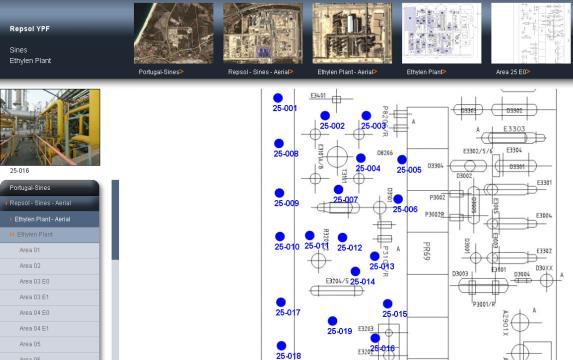
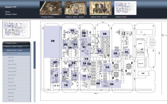
2 3D Spatial Survey Workflow Hardware Requirements Phase Based Laser Scanner: -Leica ScanStation P20 x 1EA -Usage: Short-range, ~80m Time of Flight Laser Scanner: -Leica Scanstation C10 x 1EA -Usage: Long-range, ~ 300m Portable Laser Scanner: -Mantis Vision F5 x 1EA -Usage: Close-range, ~ 4.5m Total Station: -Leica TCR 1202 x 1EA Panoramic Photo Equipment: -Canon 5D Mark II with Sigma 8mm SSP20 (2012) SSC10(2010) MV-F5(2012)
 - Ron Aarts, Adivising Director - 2 Laser Scan Teams; Each")
 - Sungwoo Cho, Director - Vikram Yedlapalli, Manager Total 15 Professionals will")
3 3D Spatial Survey Workflow People Project Managing Team (2) - Hoyong Kim, Project Director - Siro Kim, Project Manager 3D Survey Team (6) - Ron Aarts, Adivising Director - 2 Laser Scan Teams; Each Team Consists of 3 People Survey Team (2) - Sanghak Han, Chief Surveyor 3D Data Processing & Modeling Team (5) - Sungwoo Cho, Director - Vikram Yedlapalli, Manager Total 15 Professionals will be assigned!


4 3D Spatial Survey Workflow Software Registration / Data Processing: - Leica Cyclone, Model, Register, Publisher Server Software: - Leica Cyclone Server (for Large D/B, efficient collaboration) Point Cloud Enabling Software: - Leica CloudWorx for MSTN, AutoCAD Pro, SPR, SP3D, PDMS - ClearEdge 3D Edgewise Plant - INOVx RealtyLinx Exchange for PDMS Engineering 3D Design Systems: - Intergraph Smart Plant 3D and AVEVA PDMS -Autodesk Navisworks


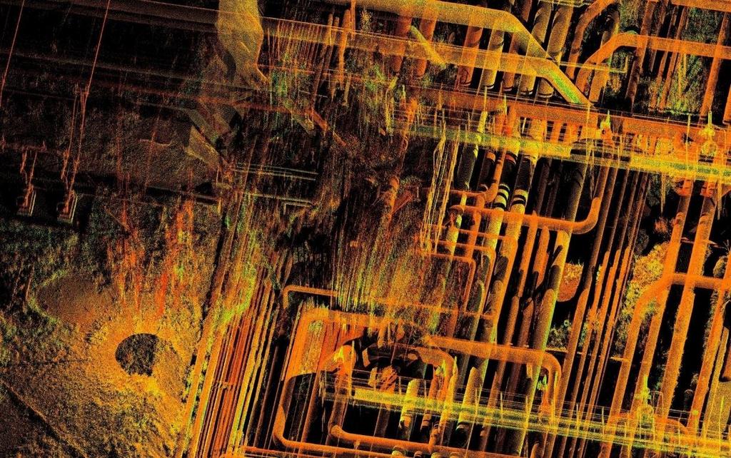
5 3D Spatial Survey Workflow 3D Laser Scanning & TPS Survey 3D laser scanning Total Station to collect target locations HDR Photography Raw as- built Scan Data (Point Cloud) Reference Coordinate System Point Cloud processing registration TrueView Database Survey Report Coordinate Drawings Cleanup Scan Data & QA / QC QA /QC reports Clash detection, etc. As-built Point Cloud Database


6 3D Spatial Survey Workflow 3D Scan PointCloud Post-Processing Cyclone Surface Modelling Cyclone Object Exchange Import & Reverse Engineering Customer S/W Data Q/A, Q/C 2D/3D As-built Data 획득

 Intergraph SmartPlant Review CloudWorx for SPR UGS FactoryCAD")
7 Top 3D Plant design systems Company Product Leica Interface Alias (Intergraph) I-Sketch PCF AVEVA PDMS CloudWorx for PDMS Bentley Systems AutoPLANT CloudWorx for AutoCAD Bentley Systems PlantSpace CloudWorx for Microstation CAE Plant4D CloudWorx for AutoCAD CloudWorx for Microstation COADE CADWorx CloudWorx for AutoCAD Dassant Systems CATIA PTS Import Intergraph PDS CloudWorx for Microstation Intergraph SmartPlant 3D 3D As-Built Model Import (or SmartPlant Review Interface) Intergraph SmartPlant Review CloudWorx for SPR UGS FactoryCAD CloudWorx for AutoCAD
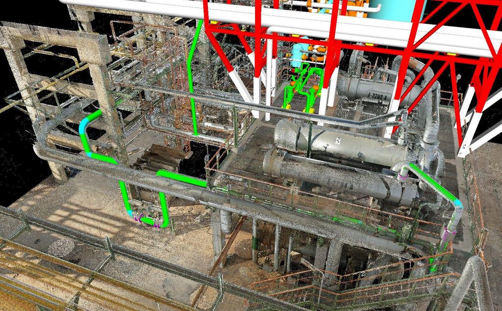
8 3D Model Intergration


9 Lsser Scans shown within design environment

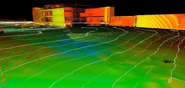
10 Truview Sample

11 Truview Sample


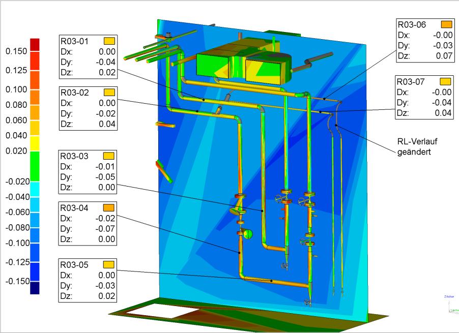
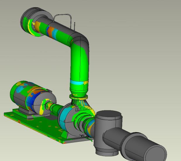
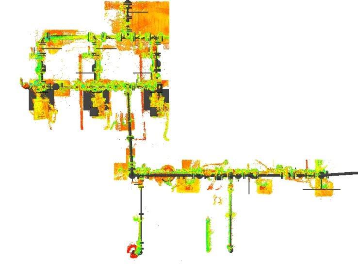
12 Laser Scan Data VS Model Data QA/QC


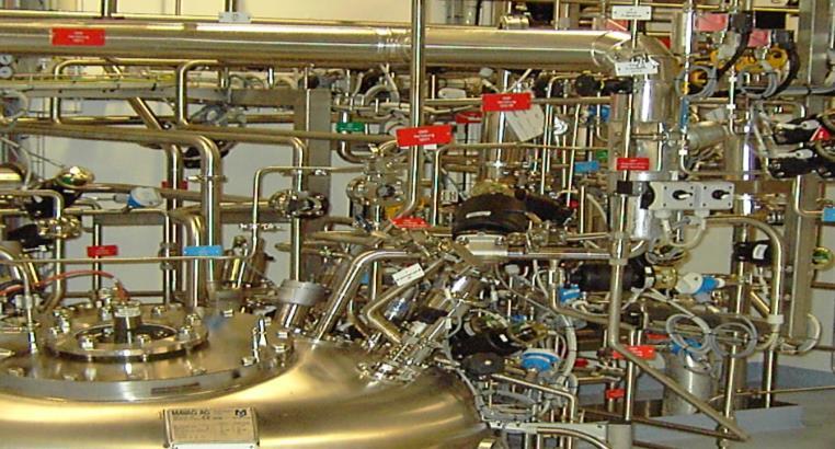

13 Laser Scanning Engineering Services Chemical Petrochemical Industrial plants Power Generation Pharmaceutical Food industry Shipping Structural Civil


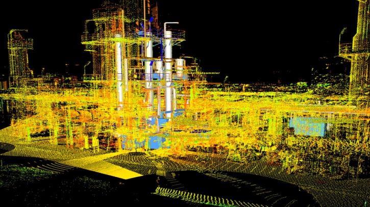
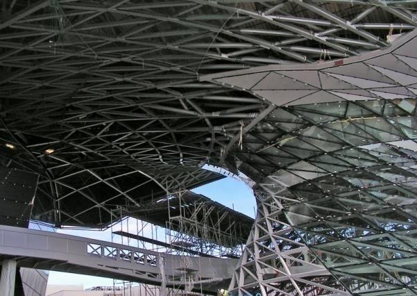
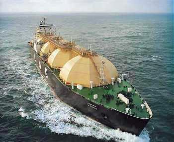
14 Shipbuilding & Offshore Platform Comprehensive 3D cloud-point scan of the entire facilities
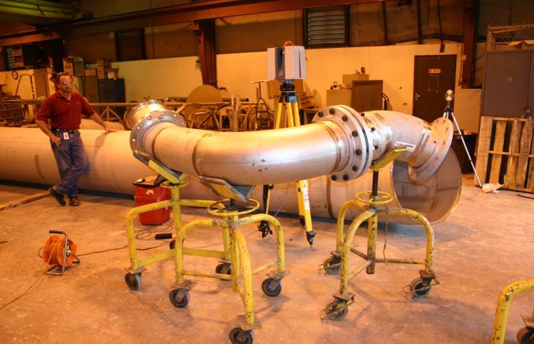
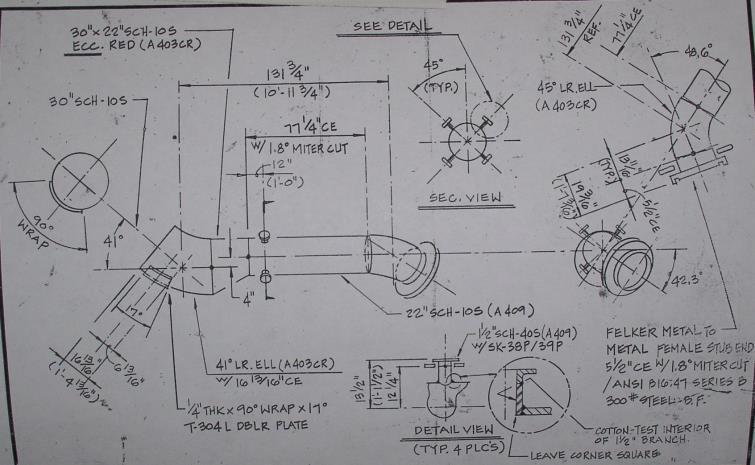
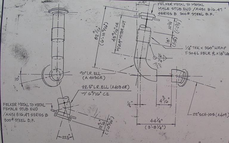
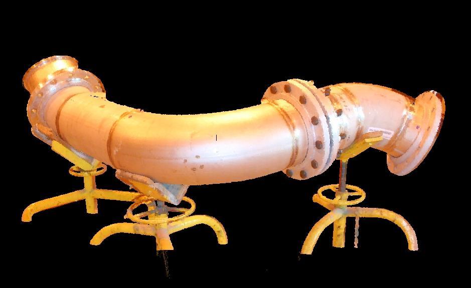
15 Pipe Fabrications Pre-Fab Piping Inspections At Fabrication Shop


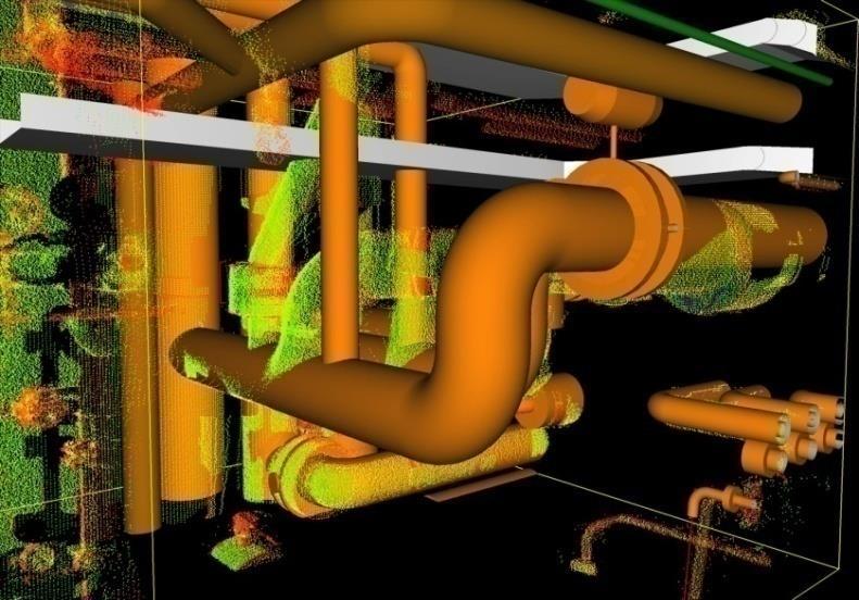
16 Scanning For Design & Installation Condenser Scans converted to models in Cyclone


17 Clash check of as built against design model CloudWorx as a plug-in for 3D Design Tools Scanned Equipment & Structures XXXXXX in PDMS or Smart Plant 3D 3D Designed Model can also directly imported in Cyclone for the clash check CloudWorx for AVEVA PDMS CloudWorx for Integraph Smart Plant 3D

18 Traditional Work Process 8 Steps

19 Laser Scan Work Process 5 Steps Skipped Process : 1. Research Existing 2. Field Measurement 3. Field Check
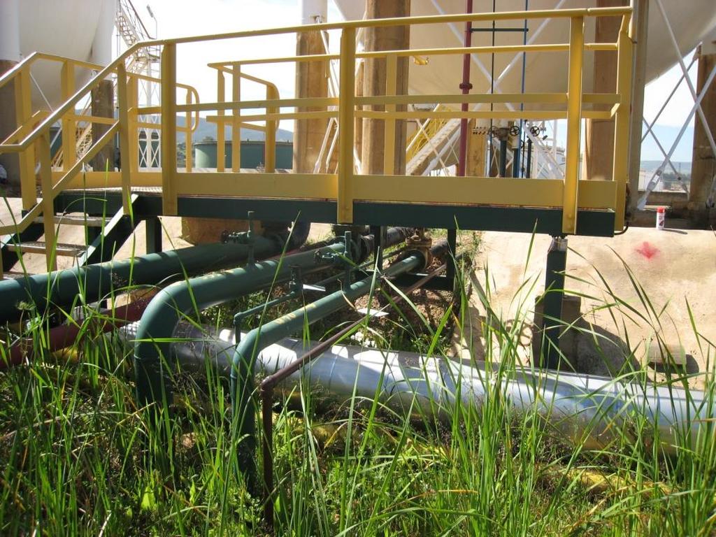
20 Obstacles: weeds
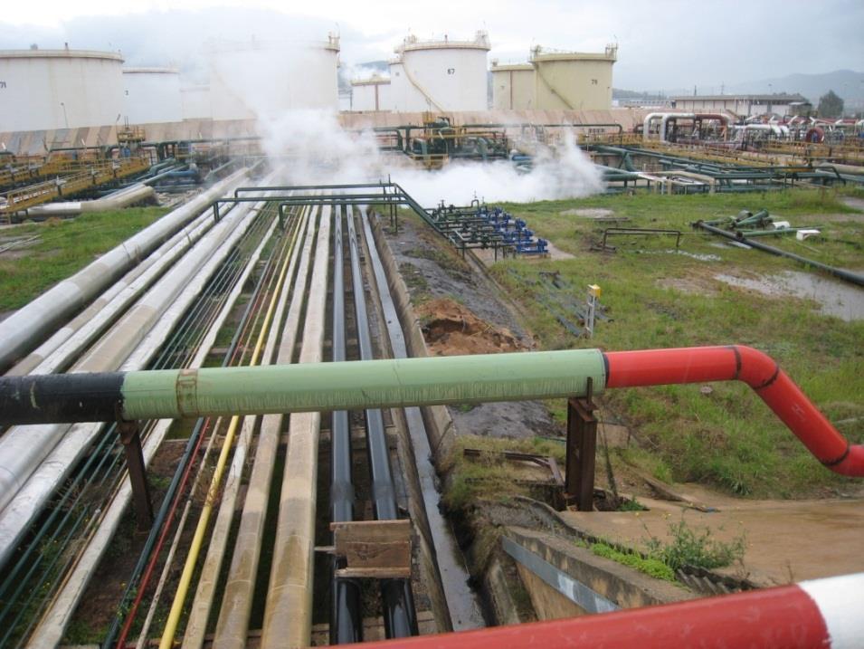
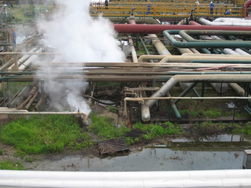
21 Obstacles: steam/marsh

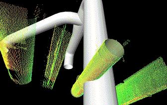
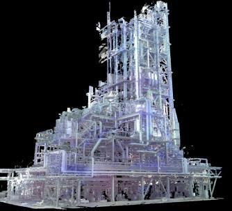
22 Geometry Modeling in Cyclone


23 Plant View Smart Plant Maintenance System
 Piping & Scan Data 비교 Modify or New")
24 SP3D Job Process Piping 3D Scan Data DGN file Conversion (Single Line) Piping & Scan Data 비교 Modify or New Drawing


")

25 SP3D Job Process Equipment & Structure 3D Scan Data DGN file Conversion (Single Line) Piping & Scan Data Comparision Modify or New Drawing


26 SK MGC Revamp Project ~ PDS Modeling


27 SAMSUNG FINE CHEMICALS MC PLANT Project ~ SP3D Modeling


28 HYUNDAI RPLC DEEP CONVERSION PROJECT ~ SP3D Modeling
Most as-built information is still manually collected. Today s Design Market
 Agenda 1. Overview of 3D laser scanning 2. HDS 3D Laser scanning applications Leica ScanStation2 True Color Scan 3. Demonstration of HDS & Trueview 4. Questions and Answers The advanced 3D Laser Scanning
Laser Scanning. 3D Model is not existing and is required for: studies revamping maintenance HSE integration in another 3D model archiving
 Laser Scanning Laser Scanning Laser scanning is used whenever: 3D Model is not existing and is required for: studies revamping maintenance HSE integration in another 3D model archiving 2 Object acquisition
ARECATECH SDN BHD CAPTURE THE REALITY IN TOUCH WITH TOMORROW
 CAPTURE THE REALITY IN TOUCH WITH TOMORROW ARECATECH SDN BHD 3D Laser Scanning Integrity and Management Services Detail Engineering Design Support & COMOS Intelligent P & ID Services SmartPlant - PDMS
Marc De Bruyne 3D Design Improvement Leader, DOW Chemical
 Marc De Bruyne 3D Design Improvement Leader, DOW Chemical John Foster Director, Profox Companies DOW Chemical Terneuzen in the Netherlands Globally, second largest DOW site after Freeport US. Producing
OPEN. INTELLIGENT. Laser Scanning Software Solutions
 OPEN. INTELLIGENT. Laser Scanning Software Solutions www.lfm-software.com The Future of Laser Scanning Safe and efficient operation of complex engineering assets, and the efficient management of their
 www.lfm-software.com LFM Software Overview Realise the true value of your laser scan data. Outside the EPC environment, Owner Operators are now also recognising the benefits of 3D laser scanning. Laser
Leveraging Point Clouds to Produce Accurate As-Built Models. Sonia Delgadillo
 Leveraging Point Clouds to Produce Accurate As-Built Models Sonia Delgadillo Time What is CADWorx fieldpipe? Easy customization Comprehensive specs Short learning curve AutoCAD -based CADWorx Plant Design
A Sweet Success in Plant Documentation for Michigan Sugar Company
 A Sweet Success in Plant Documentation for Michigan Sugar Company COMPANY LOCATION 3D Imaging Services Flint, MI TOOLS USED Leica ScanStation P40 (solutionshardware-p40.html) Leica Cyclone Software (solutionssoftware-cyclone.html)
Laser Scanning & Creation of 3D Models For BIM and Process Facilities
 Specialised Surveying Solutions Presented to: ICES UAE Region Abu Dhabi November 2009 Land and Engineering Surveying Services 3D Laser Scanning & Modeling Laser Scanning Technology Zoller+Fröhlich Phase
Leica High-Definition Surveying Systems. Leica HDS3000. The Industry Standard for High-Definition Surveying
 Leica High-Definition Surveying Systems Leica HDS3000 The Industry Standard for High-Definition Surveying HDS High-Definition Surveying TM : Laser Scanning Redefined High-Definition Surveying, or HDS,
The Leica HDS Family. The Right Tool for the Job HDS3000 HDS2500 HDS4500. Cyclone & CloudWorx. Press the QuickScan button to define the field-of-view.
 HDS2500 High accuracy scanner, ideal for fixed or raised installations when leveled tripod mounting is not practical, or areas with less stringent field-of-view requirements. The Leica HDS Family Time-of-flight
Leica ScanStation C10 The All-in-One Laser Scanner for Any Application
 The All-in-One Laser Scanner for Any Application Versatility, Productivity, Value Many organizations interested in laser scanning to diversify and/or improve current business have been waiting for a scanner
Terrestrial 3D laser scanning Practical aspects
 Terrestrial 3D laser scanning Practical aspects ISPRS WG VI/5&SC Summer School 2007 by Gregor Bilban 3D laser scanning Benefits Lower data collection costs Reduction or elimination of re-visits More accurate
Integrating Laser Scanning and 3D Capture in Shipbuilding
 Integrating Laser Scanning and 3D Capture in Shipbuilding Jen Rizzo, AVEVA Greg Lawes, point3d www.aveva.com About AVEVA The leading supplier of engineering design and information management software solutions
ROHR2. Program System ROHR2 Interfaces - Overview and Details. SIGMA Ingenieurgesellschaft mbh
 ROHR2 Program System ROHR2 Interfaces - Overview and Details ROHR2 Interfaces Feature List Content ROHR2 Introduction... 1 1 ROHR2 interfaces... 1 1.1 ROHR2 Interfaces overview... 2 1.2 Licenses and system
INTEROPERABILITY SUMMARY Leveraging 3D Designs & Data
 W H I T E P A P E R INTEROPERABILITY SUMMARY Leveraging 3D Designs & Data Referencing and Converting Existing External Data to and from Multiple Formats in Engineering and Construction Projects Contents
3D ponttechnológia használata napjainkban október. 10. Tatabány, Mérnöki továbbképzés Zeke Zsolt Mérnök üzletkötő
 3D ponttechnológia használata napjainkban 2018. október. 10. Tatabány, Mérnöki továbbképzés Zeke Zsolt Mérnök üzletkötő Leica BLK3D NEW based on photogrametry Leica HDS Termékportfólió BLK360 RTC360 P40/50
Unveiling ProjectWise Navigator V8i The Information Rich Review Alternative
 Unveiling ProjectWise Navigator V8i The Information Rich Review Alternative Tony DeRosa Interoperability Priorities Reusable and Complete Information Exchange rich heterogeneous information Rely upon secure
CloudWorx for Intergraph SmartPlant Review 1.0 Tutorial High-Definition Surveying. Tutorial-Plant
 Tutorial-Plant CloudWorx 1.0 for Intergraph SmartPlant Review CloudWorx for Intergraph SmartPlant Review provides a dynamic and flexible way to work efficiently with large as-built point clouds within
Converting Existing Piping Specs
 Converting Existing Piping Specs Ian Matthew Autodesk, Inc. PD4216: In this class, we will show you how to convert piping specs from other 3D products. This class will demonstrate how to efficiently use
3D LASER SCANNING SERVICES
 3D LASER SCANNING SERVICES O I L G A S O F F S H O R E 4 6 8 3D POINT CLOUD 3D MODEL 360 PANORAMIC VIEW ONLINE OR OFFLINE WEB PLATFORM What is 3D laser scanning? The 3D laser scanning technology is the
Extracting Plant Deliverables from AutoCAD Point Clouds
 Extracting Plant Deliverables from AutoCAD Point Clouds The webinar will begin shortly. You will hear silence until the webinar begins. Please note that this webinar is being recorded and all registrants
Leica Cyclone 5.4 Technical Specifications
 Leica Cyclone 5.4 Technical Specifications HDS Scanner control and operation Scan Scan Scan Register Model Survey Viewer Acquire and display image Acquire image at specified resolution (high, medium, low)
REGISTRATION, VISUALISATION, MODELLING & QUERY TOOLS
 REGISTRATION, VISUALISATION, MODELLING & QUERY TOOLS BASIC 3D navigation, Pan, Zoom, Rotate 3D mouse support Panoramic view mode Align to surface view mode Cloud Level of Detail for fast visualisation
BIM & Digital Transformation Scotland Live 2018 Capturing 3D Reality at the push of a button
 BIM & Digital Transformation Scotland Live 2018 Capturing 3D Reality at the push of a button Gary Kelly Country Manager Scotland Leica Geosystems @LeicaScot Capturing 3D Reality at the push of a button
Leica Cyclone 9.1 and Leica CloudWorx Technical Specifications
 Leica 9.1 and Leica CloudWorx Technical Specifications Leica 9.1 Technical Specifications REGISTRATION, VISUALIZATION, MODELING & QUERY TOOLS 3D navigation Panoramic view mode Cloud Level of Detail for
Leica Cyclone and Leica CloudWorx Technical Specifications
 Leica Cyclone and Leica CloudWorx Technical Specifications Valid as of December 2017 leica-geosystems.com REGISTRATION, VISUALISATION, MODELLING & QUERY TOOLS 3D navigation, Pan, Zoom, Rotate / 3D mouse
Displayed with permission The American Surveyor April/May Copyright 2009 Cheves Media
 NASA s Environmental Simulation Chamber A at the Johnson Space Center in Houston will require upgrades to accommodate testing of components for the new space telescopes. Laser scanning with the FARO LS
Autodesk Plant Design Suite. Build on the power and familiarity of AutoCAD with multidiscipline plant design solutions.
 Autodesk Plant Design Suite Build on the power and familiarity of AutoCAD with multidiscipline plant design solutions. The Suite Advantage: Convenient, Comprehensive, Cost-Effective Autodesk Plant Design
USE THE 3D LASER SCANNING FOR DOCUMENTATION THE RIGA CATHEDRAL IN LATVIA
 USE THE 3D LASER SCANNING FOR DOCUMENTATION THE RIGA CATHEDRAL IN LATVIA Maris Kalinka, Elina Rutkovska, Department of Geomatic, Riga Technical University, Azenes 16-109, Riga, Latvia, geomatika@geomatika.lv
Leica ScanStation C5 Scalable Laser Scanner
 Leica ScanStation C5 Scalable Laser Scanner Leica ScanStation C5 Scalable from the Start Companies entering into laser scanning are often faced with inflexible and complex situations and would like a scalable
UAVs & IMAGES ACCESSORIES ABOUT GEXCEL
 LIDAR SOFTWARE UAVs & IMAGES MONITORING MOBILE MAPPING ACCESSORIES OTHER ABOUT GEXCEL BUSINESS TEAM LOCATIONS Gexcel offices are located in Italy in two Innovation Centers SALES NETWORK Gexcel s worldwide
Leica Cyclone 8.1 Leica CloudWorx Technical Specifications
 Leica 8.1 Leica CloudWorx Technical Specifications Leica 8.1 Technical Specifications HDS SCANNER CONTROL AND OPERATION & REGISTRATION Acquire and display image ^ ^ ^ Acquire image at specified resolution
Leica Cyclone 9.1 and Leica CloudWorx Technical Specifications
 Leica 9.1 and Leica CloudWorx Technical Specifications Leica 9.1 Technical Specifications REGISTRATION, VISUALISATION, MODELLING & QUERY TOOLS 3D navigation, including 3D mouse support Panoramic view mode
Simplicity is the new black: The BLK360 story
 Simplicity is the new black: The BLK360 story Vanda KADLECIKOVA Leica Geosystems Heerbrugg, Switzerland E-mail: vanda.kadlecikova@leica-geosystems.com Abstract Meet the game changer. The new Leica BLK360
Scan-to-BIM. NEWBIM ApS, Galina Slavova CEO, BIM Specialist
 Scan-to-BIM NEWBIM ApS, Galina Slavova CEO, BIM Specialist Agenda What is Building Information Modeling (BIM) About NEWBIM ApS 3D Laser Scanning Integration Case Study Demonstration Building Information
Engineering Systems Manager
 02/04/2006 1 Engineering Systems Manager Colin K Fairweather 02/04/2006 2 Point Cloud Data With PDMS On Brownfield Projects What are the benefits and why use the technology? 02/04/2006 3 The History of
3D Industrial plants. Documentation
 3D Industrial plants Documentation Published by: FARO Europe GmbH & Co. KG, Lingwiesenstrasse 11/2, D-70825 Korntal-Münchingen, Tel: +49 7150 9797-0, Fax: +49 7150 9797-44, info@faroeurope.com, www.faro.com
Converting Existing Specs and Catalogs for Use in Autodesk AutoCAD Plant 3D
 Converting Existing Specs and Catalogs for Use in Autodesk AutoCAD Plant 3D Tarryn de Magalhaes Plant Solutions Consultant Caddman (Pty) Ltd TazDAutoCADguru Join us on Twitter: #AU2013 My Background Autodesk
Trimble Realworks Software
 TECHNICAL NOTES Trimble Realworks Software A Powerful 3D Laser Scanning Office Software Suite DESIGNED FOR TODAY S MULTIFACETED SCANNING PROFESSIONAL, TRIMBLE REALWORKS IS A POWERFUL OFFICE SOFTWARE THAT
ISO and interoperability Proteus and XMpLant technology. Adrian Laud Noumenon Consulting Ltd May Why ISO 15926?
 ISO 15926 and interoperability Proteus and XMpLant technology Adrian Laud Noumenon Consulting Ltd May 2010 Why ISO 15926? Years Months Days To date to create the standard 1 ISO 15926 in use today 80 major
RealWorks Software. A Powerful 3D Laser Scanning Office Software Suite
 TECHNICAL NOTES RealWorks Software A Powerful 3D Laser Scanning Office Software Suite Trimble RealWorks is a powerful office software that imports rich data from your 3D laser scanning instrument and transforms
Suite en It Up with Autodesk ReCap
 Chad Studer ADSK Solutions RC3165 Static and mobile laser scanning technologies capture millions of points and provide photorealistic interactive virtual sites known as point clouds. With Autodesk ReCap
General Software. Program (Software House) Function. Office Productivity. Office (Microsoft) PDF File Generation and Management
 Function. Office Productivity. Office (Microsoft) PDF File Generation and Management") Company Software General Software Office (Microsoft) Office Productivity Acrobat Professional (Adobe) Primavera P6 Professional R8.2 (Oracle) Microstation Ver.J, V8,XS and all versions (Bentley) Autocad
Company Software General Software Office (Microsoft) Office Productivity Acrobat Professional (Adobe) Primavera P6 Professional R8.2 (Oracle) Microstation Ver.J, V8,XS and all versions (Bentley) Autocad
Bentley OpenPlant PowerPID
 Bentley OpenPlant PowerPID Agenda Presenter Rob Harper Director of Product Management OpenPlant PowerPID Overview What is OpenPlant PowerPID OpenPlant PowerPID Features Specification Mapping and 2D to
technical notes trimble realworks software
 technical notes trimble realworks software A POWERFUL 3D LASER SCANNING OFFICE SOFTWARE SUITE Designed for today s multifaceted scanning professional, Trimble RealWorks is a powerful office software that
Reality Capture using: RPAS Technologies & Image Laser Scanners
 Reality Capture using: RPAS Technologies & Image Laser Scanners by Johan Erasmus (RPAS Technologies) & Barend Bornman (Image Laser Scanners) from Aciel Geomatics Laser Scanners High-Definition Surveying
Leica Cyclone and Leica CloudWorx Technical Specifications
 Leica Cyclone and Leica CloudWorx Technical Specifications Valid as of August 2018 leica-geosystems.com Key 1 These types can be created using best-fit methods 2 As delivered in database, cannot modify
Terrestrial LiDAR. Patrick Crawford. Harnessing the Power of Big Data for Asset and Facility Management WHITE PAPER SHAFER, KLINE & WARREN
 WHITE PAPER Terrestrial LiDAR Harnessing the Power of Big Data for Asset and Facility Management Patrick Crawford Team Leader, Geospatial Systems SHAFER, KLINE & WARREN Executive Summary Terrestrial LiDAR
With FARO PointSense for Revit. Jörg Braunes Platform Owner Software Chris Palmer Sales Engineer 1
 From Point Clouds to BIM Models With FARO PointSense for Revit Jörg Braunes Platform Owner Software Chris Palmer Sales Engineer 1 Agenda Scan to BIM with Revit PointClouds in Revit Advanced Workflow with
ON THE ROAD JULY/AUGUST MAP PROJECTIONS The importance of horizontal and vertical datums in GIS mapping
 VOLUME 4 ISSUE 5 JULY/AUGUST 2014 ON THE ROAD 30 40 62 MAP PROJECTIONS The importance of horizontal and vertical datums in GIS mapping FOLLOW THE LEDDAR A special purpose sensor that does several 3D measurement
Realworks Software. A Powerful 3D Laser Scanning Office Software Suite
 TECHNICAL NOTES Realworks Software A Powerful 3D Laser Scanning Office Software Suite Trimble RealWorks is a powerful office software that imports rich data from your 3D laser scanning instrument and transforms
Geosystems Monday Hands-on Sessions
 Geosystems Monday Hands-on Sessions 1110: HDS University - Leica ScanStation P30/40 (and C10 & P20) Operation and Surveying Workflows (CEU eligible nominal fees will apply) The all new Leica ScanStation
DEMO OF SMART STRESS ISO (SSI)
") DEMO OF SMART STRESS ISO (SSI) The information flow in the complete Life Cycle Solution is the following: PDS PDMS AutoPlant Piping Specs I-EXPORT IDF/PCF I-CONVERT I-SKETCH (ISOGEN) PIPENET Standard PIPENET
DEMO OF SMART STRESS ISO (SSI) The information flow in the complete Life Cycle Solution is the following: PDS PDMS AutoPlant Piping Specs I-EXPORT IDF/PCF I-CONVERT I-SKETCH (ISOGEN) PIPENET Standard PIPENET
Geospatial Engineering Problems & Solutions Associated With NDP Roads, Tunnelling & Civil Engineering Projects Use of HDS Leica Laser Scanners
 Geospatial Engineering Problems & Solutions Associated With NDP Roads, Tunnelling & Civil Engineering Projects Use of HDS Leica Laser Scanners Laser Scanning Laser Scanning is a method of collecting large
Bentley Descartes and what s new in Descartes V8i (SELECTseries 3) What is Bentley Descartes? 2011 Bentley Systems, Incorporated
 What is Bentley Descartes? 2011 Bentley Systems, Incorporated") Bentley Descartes and what s new in Descartes V8i (SELECTseries 3) Tom Stogdill Bentley Systems, Inc. What is Bentley Descartes? Image Processing Raster Geo-Referencing Advanced raster transformation (warping,
Bentley Descartes and what s new in Descartes V8i (SELECTseries 3) Tom Stogdill Bentley Systems, Inc. What is Bentley Descartes? Image Processing Raster Geo-Referencing Advanced raster transformation (warping,
Autodesk Plant Design Suite. Integrated solutions for plant design and whole-project review
 Autodesk Plant Design Suite Integrated solutions for plant design and whole-project review The Suite Advantage The suite combines AutoCAD, AutoCAD P&ID, AutoCAD Plant 3D, and Autodesk Navisworks software
Intergraph Pds 8 Install Tutorial Manual READ ONLINE
 Intergraph Pds 8 Install Tutorial Manual READ ONLINE Installation Intergraph Pds Guide - Pds Intergraph Tutorial Manual booklad.org Project Name and Logo Monday, intergraph pds installation guide New Version
Trimble RealWorks. What s new in version 9.0
 Trimble RealWorks What s new in version 9.0 Trimble RealWorks v9.0 What s new Over 40 new features and enhancements Navigation and visualization improvements SketchUp interoperability Additional 3 rd party
Product Release Summary AVEVA LFM Server
 Product Release Summary AVEVA LFM Server 5.0.0.5 Release Date: 18/03/2019 This document outlines all changes made in the above release of AVEVA LFM Server. Document Prepared by: Praveen Vankdoth Application
Z+F IMAGER 5006i. The new way of scanning highly accurate, fast, reliable and flexible
 Z+F IMAGER 5006i The new way of scanning highly accurate, fast, reliable and flexible Z+F IMAGER 5006i An improved system based upon the highly regarded Z+F IMAGER 5006 Stand alone concept Improved point
Autodesk Revit Architecture 2017 Guida Alla Progettazione Bim
 Autodesk Revit Architecture 2017 Guida Alla Progettazione Bim We have made it easy for you to find a PDF Ebooks without any digging. And by having access to our ebooks online or by storing it on your computer,
Product Release Summary AVEVA LFM Server
 Product Release Summary AVEVA LFM Server 4.4.2.19 Release Date: 02/08/2018 This document outlines all changes made in the above release of AVEVA LFM Server. Document Prepared by: Praveen Vankdoth Application
What s New in Autodesk Inventor 2019
 What s New in Autodesk Inventor 2019 Welcome & Agenda Inventor 2019 Professional Grade Connected Inventor Experience Accessing the update Q&A Designed in Inventor by Benoit Belleville. Available for download
Documentation Shipbuilding & Marine Engineering
 Documentation 3D Shipbuilding & Marine Engineering Published by: FARO Europe GmbH & Co.KG, Lingwiesenstraße 11/2, D-70825 Korntal-Münchingen, Tel: +49 7150 9797-0, Fax: +49 7150 9797-44, info@faroeurope.com,
Leica No Date From To. software for. We are pleased to. point cloud. system. Grid and intelligen. Orientati. Then you. view.
 No Date From To 27-2013 BU Terrestrial Laser Scanning 29 th October 2013 Bill Wallace All representatives Leica CloudWorx for AutoCAD 5.0 Product Release Announcement We are pleased to announce the release
EXPERT TIPS & TRICKS MAR/APR 2017
 VOLUME 7 ISSUE 2 MAR/APR 2017 EXPERT TIPS & TRICKS 21 27 30 DRONE-BASED LIDAR STUDY To evaluate the effectiveness of drone-based LIDAR tech Juniper Unmanned conducted a unique empirical study OIL AND GAS
ROHR2 Interfaces. Program System ROHR2 Interfaces - Overview and Details. SIGMA Ingenieurgesellschaft mbh
 Program System ROHR2 Interfaces - Overview and Details Contents 1 Integration of ROHR2... 1 2 Interfaces to CAD-Systems... 2 2.1 2D CAD-Systems - Overview... 2 2.2 Neutral Interface... 3 2.3 Interface
EXPERIENCES ON DEVELOPMENT OF A 4D PLANT CONSTRUCTION SIMULATION SYSTEM
 EXPERIENCES ON DEVELOPMENT OF A 4D PLANT CONSTRUCTION SIMULATION SYSTEM Shang-Hsien Hsieh 1, Chuin-Shan Chen 2, Yuan-Fu Liao 3 Cheng-Tao Yang 4, and I-Chen Wu 5 ABSTRACT This paper reports the experiences
3D Manufacturing Facility and Production Line Capture
 SPAR 2004 Symposium May 19, 2004 3D Manufacturing Facility and Production Line Capture Presented by: Bill Campbell GM Vehicle Operations Competitive Operations Engineering Mike Ryan GHAFARI Companies SPAR
Multidiscipline CAD Usage at an EPC Company Jimmy Bergmark Pharmadule Emtunga AB / JTB World
 November 28 December 1, 2005 Orlando, Florida Multidiscipline CAD Usage at an EPC Company Jimmy Bergmark Pharmadule Emtunga AB / JTB World PD12-1 This case study will discuss CAD usage at Pharmadule Emtunga.
Integrated Field to Finish BIM for Surveyors. Boris Skopljak Market Manager, Trimble Geospatial Office Software
 Integrated Field to Finish BIM for Surveyors Boris Skopljak (boris_skopljak@trimble.com) Market Manager, Trimble Geospatial Office Software Agenda Trimble Introduction BIM relevance in Trimble Trimble
Leica Geosystems QuickStart Guide
 Leica Geosystems QuickStart Guide Product Leica Cyclone REGISTER 360 1.4.1 Date 3 January 2018 From HDS Software Product Management Contents Introduction... 2 Installation... 3 Licensing Setup... 4 Basic
COADE. CADWorx. Plant Design Suite
 COADE CADWorx Plant Design Suite CADWorx: The most complete plant design suite for the AutoCAD platform! CADWorx is COADE s integrated series of AutoCAD -based tools for plant design that provides intelligent
QuickStart Guide: Leica Cyclone REGISTER 360
 Leica Geosystems QuickStart Guide: Cyclone REGISTER 360 Product Leica Cyclone REGISTER 360 1.4 Date 17 October 2017 From HDS Software Product Management Contents Introduction... 2 Installation... 3 Licensing
Leica BLK360 Questions & Answers. Vers
 Questions & Answers Vers. 11.01.2017 What is it? 2 What is it? 3 What is it? Calibrated full spherical image, LED flash support 4 What is it? 5 A new, simple way to capture reality Speed On-the-fly image
A selection of our previous clients:
 Survey Solutions Geo-Spatial Survey Solutions Ltd Contact: Tel: Email: Y X Roger Davies 07713 160041 roger.davies@geo-spatial.co.uk www.geo-spatial.co.uk A selection of our previous clients: English Heritage
Explore Laser Scanning in As-Built Survey. Vijay Chowdhary SE: BIM/CIM
 Explore Laser Scanning in As-Built Survey Vijay Chowdhary SE: BIM/CIM About FARO The world leader in portable 3-D measurement and imaging technology EMEA Headquarters Korntal-Münchingen, Germany APAC Headquarters
Trimble 3D Laser Scanning TRANSFORMING THE WAY THE WORLD WORKS
 Trimble 3D Laser Scanning Speed, Precision and Versatility Complete Solutions for Every Challenge CAPTURE AND DELIVER PRECISE DATA. FASTER. For scanning professionals, speed and precision are critical.
Figure 1: Mobile mapping project location in New York City.
 Using Mobile LiDAR to Deliver Survey Accurate Data This presentation will take the attendees though the process of controlling and delivering survey grade LiDAR data for use in CADD, Modeling, and GIS
Efficient and Effective Quality Assessment of As-Is Building Information Models and 3D Laser-Scanned Data
 Efficient and Effective Quality Assessment of As-Is Building Information Models and 3D Laser-Scanned Data Pingbo Tang 1, Engin Burak Anil 2, Burcu Akinci 2, Daniel Huber 3 1 Civil and Construction Engineering
3D SPATIAL DATA ACQUISITION AND MODELING OF ANGHEL SALIGNY MONUMENT USING TERRESTRIAL LASER SCANNING
 JOURNAL OF APPLIED ENGINEERING SCIENCES VOL. 2(15), issue 2_2012 ISSN 2247-3769 ISSN-L 2247-3769 (Print) / e-issn:2284-7197 3D SPATIAL DATA ACQUISITION AND MODELING OF ANGHEL SALIGNY MONUMENT USING TERRESTRIAL
2011 Bentley Systems, Incorporated. Bentley Descartes V8i (SELECTseries 3) Advancing Information Modeling For Intelligent Infrastructure
 Advancing Information Modeling For Intelligent Infrastructure") Bentley Descartes V8i (SELECTseries 3) Advancing Information Modeling For Intelligent Infrastructure What is Bentley Descartes? Image Processing Raster Geo-Referencing Advanced raster transformation (warping,
Bentley Descartes V8i (SELECTseries 3) Advancing Information Modeling For Intelligent Infrastructure What is Bentley Descartes? Image Processing Raster Geo-Referencing Advanced raster transformation (warping,
Draper Aden VIRTUAL CONSTRUCTION DOCUMENT, DESIGN, AND BUILD IN 3D
 VIRTUAL CONSTRUCTION VIRTUAL CONSTRUCTION The design and construction environment has changed. While the goals of completing a project on time, within budget, and at the expected level of quality remain
COMPLEX 3D BIM OCT/NOV PORTABLE NUKE INSPECTIONS Might a backpack and ultra-portable LIDAR technology make the world a safer place?
 VOLUME 5 ISSUE 7 OCT/NOV 2015 COMPLEX 24 40 50 PORTABLE NUKE INSPECTIONS Might a backpack and ultra-portable LIDAR technology make the world a safer place? APPLYING FOR A 333 EXEMPTION Vertical Information
SmartPlant Fusion: Technology and Capabilities
 W H I T E P A P E R SmartPlant Fusion: Technology and Capabilities The Fastest and Smartest Way to Make Documents and Drawings Available for Decision Support Contents 1. Introduction... 1 2. SmartPlant
Leica Cyclone 7.0 Leica CloudWorx 4.0 and 2.0 Technical Specifications
 Leica Cyclone 7.0 Leica CloudWorx 4.0 and 2.0 Technical Specifications Leica Cyclone 7.0 Technical Specifications HDS Scanner Control and Operation Acquire and display image Acquire image at specified
Structural Engineering Training courses :
 Structural Engineering Training courses : Course BIM Structural Diploma Revit Structure Robot Structure Analysis Autocad Structure Detailing Navis Works BIM Structural Diploma BIM structural diploma maximize
Cross-Discipline Coordination in Autodesk s Revit Platform
 Cross-Discipline Coordination in Autodesk s Revit Platform Matt Dillon The DC CADD Company, Inc. AB214-4 The Revit platform offers many opportunities and tools for coordination that have not been possible
Customer Product Release Summary LFM Server Release Date: 20/11/2017
 Customer Product Release Summary LFM Server 4.4.1.23 Release Date: 20/11/2017 This document outlines all changes made in the above release of LFM software. Document Prepared by: Arun Putcha Application
Laser Scanning Specification
 Laser Scanning Specification Visual Surveys [Laser] LFM-TR-003-001-DOC-R1 Prepared for: Revision: 0.2 Prepared By: Issue Date: OPEN. INTELLIGENT. Laser
Complete Construction Digital Documentation.a record for Life.
 Complete Construction Digital Documentation.a record for Life. PHOTO. VIDEO. WEBCAM. Total Asset Visibility Developed In Vancouver 2013 Operates in 48 Offices around the world Last 3 years have Documented
Landfill Grading Using GPS Machine Control
 Landfill Grading Using GPS Machine Control NC SWANA April 2018 Presented by: Bernie Garrett, PE Garrett & Moore Inc. & Gabe Leach Cooper Barnette & Page Inc. 1 Purpose Work flow processes used by Engineers,
2006 3D Laser Scanner Hardware Survey
 2006 3D Laser Scanner Hardware Survey MANUFACTURER PRODUCT PERFORMANCE Laser Wavelength (in nm) Laser Power (in W, mw) FDA Laser Classification (Class) Beam Diameter at Specified Distance from the Scanner
Documentation. Architecture & Construction Markets
 3D Documentation Architecture & Construction Markets CONTENTS 01Page 06 02Page 10 03Page 14 04Page 18 05Page 22 06Page 26 07Page 28 08Page 30 09Page 31 Building Construction Facility Management Building
Autodesk Utility Design and Your GIS
 UT4523-P Autodesk Utility Design and Your GIS Prashant Srivastav Quality Assurance Lead, Utilities Co Speakers: Jeff Saunders, Carsten Hess The Power Track Utility Design Power Track at a glance... and
aveva.com LASER FOCUSED How the use of laser scanning and 3D modelling is modernising shipyard operations WHITE PAPER September 2017
 aveva.com LASER FOCUSED How the use of laser scanning and 3D modelling is modernising shipyard operations WHITE PAPER September 2017 WHITE PAPER 2 TIME TO TRANSFORM Shipyards around the world are going
HIGH-DEFINITION SURVEY AND BIM PRESENTATION FOR BIM-MEP AUS
 www.aamgroup.com/bim HIGH-DEFINITION SURVEY AND BIM PRESENTATION FOR BIM-MEP AUS Matt Rumbelow, B.Arch AAM BIM Coordinator ABOUT AAM Reality Captured. Certainty Delivered Reality Captured. Certainty Delivered
BIM PROCESS COMPARING NEW BUILD WITH EXISTING ASSETS A VERY QUICK SUMMARY OF THE PROCESS
 : STEPPING INTO THE FUTURE WITH THE PAST HYBRID MODELLING IN THE BIM PROCESS CARL BROOKES 8 DECEMBER 2017 INTRODUCTION Very quick summary of BIM process Comparing New build with existing assets 3D model
Leica Geosystems Release Notes
 Leica Geosystems Release Notes Product Cyclone REGISTER 360 Version 1.4 Date 17 th October 2017 From HDS Software Product Management Contents INTRODUCTION...2 FEATURES...2 COMPUTER SPECIFICATIONS...2 Minimum