3D Data Modelling at Esri. Paul Hardy Business Development Consultant Esri Europe
|
|
|
- Laura Fleming
- 6 years ago
- Views:
Transcription


1 3D Data Modelling at Esri Paul Hardy Business Development Consultant Esri Europe

2 Users of 3D GIS Local government Facilities management Civil engineering 3D GIS Defense / Public Safety Natural resources


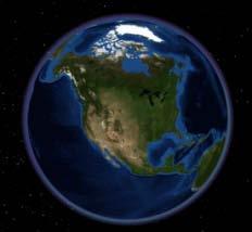
3 3D GIS Viewing geospatial data in 3D leads to new insights 2D 3D Sometimes you need to edit your data in 3D 2D 3D Some problems can only be solved in 3D 3D 3D We live in a 3D world, so model and present your data in 3D


4 ArcGIS A complete system for 3D GIS Visualize Manage Share Analyze Your City Data in 3D


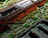
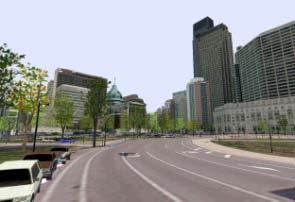
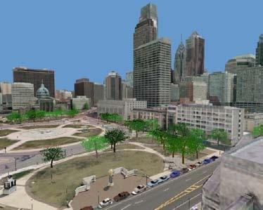
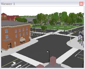
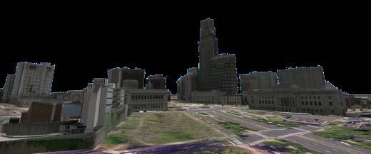
5 Virtual City Template - Philadelphia Visualization ingredients optimization City Management creation / storage updates 3D City Analyses Visibility Shadow/glare effects 3D routing Sharing of Virtual City


6 Visualize Virtual Philadelphia ingredients Visualize Manage Analyze Share Topographic maps Aerial photographs High resolution terrain Visual Impact Before After Photo realistic 3D buildings Providing 3D insight into your information

7 Ingredients Topographic basemap Visualize Manage Analyze Share Streets Shaded Relief Vegetation Labels Buildings Map Template Resource Center Topographic basemap


8 Ingredients Imagery Visualize Manage Analyze Share ArcGIS Server Image Extension Imagery from ArcGIS Online Resource Center


9 Ingredients Elevation Visualize Manage Analyze Share Elevation Globes from ArcGIS.com

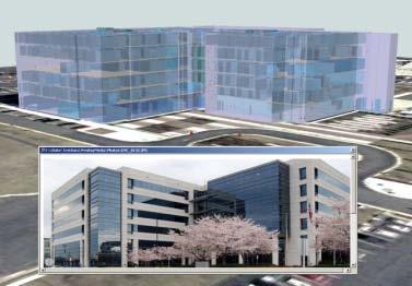
10 Ingredients Buildings Visualize Manage Analyze Share Extruded Buildings Textured Buildings Sources of textured buildings - Pictometry Building your own multipatch buildings


11 ArcGIS for 3D ArcGIS Desktop ArcGIS Server ArcGlS.com ArcMap ArcGlobe ArcCatalog ArcScene ArcGlS Explorer (Free Download) ArcGIS Explorer Online (Browser)
 3D Models: Street furniture, etc.")
 3D Texture Line Symbols 3D Polygons 3D Texture Fill Symbols Elevation grid rasters (DTM/DEM) Terrains")
12 3D Datatypes in the Geodatabase Vector feature classes with X,Y,Z geometry 3D Points 3D Geometric primitives (spheres, pyramids, ) 3D Models: Street furniture, etc. 3D Character Markers, or Billboarded Markers 3D Lines 3D Geometric primitives (ribbons, tubes. ) 3D Texture Line Symbols 3D Polygons 3D Texture Fill Symbols Elevation grid rasters (DTM/DEM) Terrains (TIN, Point cloud, surface) Multipatch (volumetric bodies)


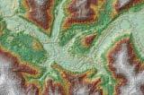
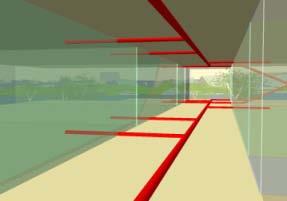
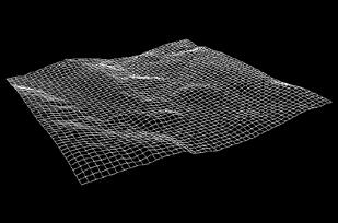
13 Introducing Terrains Massive point datasets with a multi-resolution, on-the-fly TIN For modelling 3D surfaces Measurements stored as feature classes within a feature dataset User defined pyramid levels for different resolutions & tolerances 3D Analyst extension required to define & edit terrains No license needed to view A
14 Characteristics of Terrains Terrains quickly deploy & visualize TIN based surfaces at multiple scales Derived from a set of feature classes with features that contain z-values Different pyramid level TINs can be defined Breaklines & polygons can be added to further delineate surface CdnRockies CdnRockies_Terrain Points Breaklines LakeBoundaries Pyramid TIN surfaces


15 Terrains in ArcGIS Assist visualization & analysis of multi-resolution data Can integrate with other geospatial information Multi-user access in a versioned GDB ArcMap ArcGlobe Displays as a TIN Layer Displays as an Elevation Layer


16 Introducing Multipatch A geodatabase feature type for 3D objects. Collection of triangle strips, triangle fans, triangles, and rings Allow storage of texture image, colour, transparency, and lighting vector information within the geometry


17 Triangle Strip A continuous, linked strip of 3D triangles where every vertex after the first two completes a new triangle


18 Triangle Fan A continuous fan of 3D triangles where the first point defines the apex that all triangles share
19 Triangle A collection of 3D triangles where each consecutive triplet of vertices defines a new triangle


20 Ring A geometric element from which polygons are constructed, defined by an area bounded by one closed sequence of connected segments


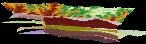
21 Collections can be complex A single composite multipatch can contain multiple patches of varying types

22 Textures can be applied Two rings and one triangle strip Different textures for roof, floor and walls

23 Multipatch in Catalog


24 Data Collection Elevation Types of Data Imagery Subsurface Models and Multipatches Topographic (2 or 3D) Additional Features Across Scales Local Regional Global


25 Data Conversion: Import 3D Files Input Formats COLLADA SketchUp OpenFlight 3ds Max GeoVRML These formats can store geographic location


26 Data Conversion: Data Interoperability Extension Can convert a large variety of formats to the Geodatabase CityGML IFC Can control the type of data that is produced


27 Data Conversion: Layer 3D to Feature Class 3D Symbology Extrusion Settings Texture Downsampling


28 Manage Virtual Philadelphia Visualize Manage Analyze Share Create 3D city elements Import / replace buildings Scale Move, rotate Export to COLLADA Create, Build, and Manage Virtual Cities in 3D


29 Analyze Virtual Philadelphia Visualize Manage Analyze Share Maximum building height Skyline analysis 3D routing Volumetric Shadows Volumetric Glare Enabling better decisions leveraging 3D


30 Civil engineering / Natural resources Visualize Manage Analyze Share LiDAR in terrain dataset Manage subsurface well points Profile LiDAR points Create subsurface horizons TIN editing Create, Build, and Manage GIS in 3D


31 Civil engineering / Natural resources Visualize Manage Analyze Share Elevation Slope 3D Viewshed Hillshade Aspect Fence diagrams Flood plain Enabling better decisions leveraging 3D


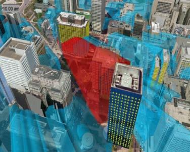
32 Defense / Public Safety Visualize Manage Analyze Share Threat domes Sniper / Spotter coverage Emergency 3D routing Airspace infringement Security camera coverage Enabling better decisions leveraging 3D


33 Facilities Management Campus model Visualize Manage Analyze Share Campus 3D transportation network Spaces within a building Interior assets Partners: PenBay Media Archibus Woolpert Providing 3D insight into your information


 Enabling")
34 Facilities Management Campus model Visualize Manage Analyze Share Interior transportation networks Interior direct sunlight Space management: Parking distance analysis (MIT campus) Enabling better decisions leveraging 3D
35 Optimized Visualisation Ingredients Fast rendering of 2D map caches in ArcGlobe Topographic maps and imagery as 2D cache Improved display performance of 3D annotation / Point labeling built-in conflict detection Fast display of textured multi-patches automatic textures management Improved display performance of 3D vectors surface-hugging vectors


36 Sharing Virtual Cities Visualize Manage Analyze Share WebGIS Publish Virtual Cities as 3D services KML Post to ArcGIS.com Create screenshots Mobile 3D Export video animations Communicating GIS using 3D

37 Sharing ArcGIS Explorer free download Visualize Manage Analyze Share Interactive 3D Maps Share Video Animations Maps and Screenshots Communicating GIS using 3D

38
From 2D to 3D at Esri
 From 2D to 3D at Esri OGC/EuroSDR workshop on CityGML in National Mapping Paul Hardy phardy@esri.com Business Development Consultant National Mapping & Cadastre Esri 3D GIS Visualize Manage Share Analyze
From 2D to 3D at Esri
 From 2D to 3D at Esri Paul Hardy, Esri Inc phardy@esri.com, Cambridge, UK SHORT PAPER This short paper provides an overview of the 3D capabilities of a modern GIS, illustrated by the Esri ArcGIS system,
Creating, managing and utilizing a 3D Virtual City in ArcGIS Tamrat Belayneh Eric Wittner
 Creating, managing and utilizing a 3D Virtual City in ArcGIS 10.1 Tamrat Belayneh (tbelayneh@esri.com) Eric Wittner (ewittner@esri.com ) Contents 3D Mapping & Ingredients of a 3D Virtual City Creating
Paul Hardy. We Live in a Rapidly Changing World. Mobile Mapping: Collect, Manage, Produce, Share. MMT Krakow, Many Forces Are Converging
 Mobile Mapping: Collect, Manage, Produce, Share MMT Krakow, 2011 Paul Hardy We Live in a Rapidly Changing World Increasingly Driven by Population Growth & Human Action Impacting Environment Society Economy
3D Analyst Visualization with ArcGlobe. Brady Hoak, ESRI DC
 3D Analyst Visualization with ArcGlobe Brady Hoak, ESRI DC 3D GIS Viewing geospatial data in 3D leads to new insights 2D 3D Sometimes you need to edit your data in 3D 2D 3D Some problems can only be solved
Esri UC2013. Technical Workshop. Type Presentation Name Here
 Type Presentation Name Here 2013 Esri International User Conference July 8 12, 2013 San Diego, California Technical Workshop 3D Analyst An Introduction Deepinder Deol Michael Contreras Why use 3D GIS?
Contents What is 3D Mapping Creating g the 3D Dataset Ingredients of a 3D Virtual City Publishing 3D Globes The Road ahead Questions and Answers
 Creating a 3D Virtual City Using ArcGIS Tamrat Belayneh Hardeep Bajwa Contents What is 3D Mapping Creating g the 3D Dataset Ingredients of a 3D Virtual City Publishing 3D Globes The Road ahead Questions
GEOGRAPHIC INFORMATION SYSTEMS Lecture 25: 3D Analyst
 GEOGRAPHIC INFORMATION SYSTEMS Lecture 25: 3D Analyst 3D Analyst - 3D Analyst is an ArcGIS extension designed to work with TIN data (triangulated irregular network) - many of the tools in 3D Analyst also
Sharing 3D Content on the Web
 Sharing 3D Content on the Web Nathan Shephard, Gert van Maren Why 3D GIS? Because our world is 3D Improve understanding 3D is easy for everyone to understand Better communication 3D makes it easier to
3D Analysis Tools and Visualization with ArcGIS. Jie Chang Jinwu Ma
 3D Analysis Tools and Visualization with ArcGIS Jie Chang Jinwu Ma Why 3D GIS? Because our world is 3D Improve understanding 3D is easy for everyone to understand Solve 3D problems Some spatial problems
Visualization with ArcGlobe. Brady Hoak
 Visualization with ArcGlobe Brady Hoak Contents What is ArcGlobe? 3D Mapping and ArcGlobe Displaying data in ArcGlobe ArcGlobe tools Tips for constructing ArcGlobe documents New at ArcGIS 9.3 ArcGIS integration
COPYRIGHTED MATERIAL. Introduction to 3D Data: Modeling with ArcGIS 3D Analyst and Google Earth CHAPTER 1
 CHAPTER 1 Introduction to 3D Data: Modeling with ArcGIS 3D Analyst and Google Earth Introduction to 3D Data is a self - study tutorial workbook that teaches you how to create data and maps with ESRI s
Introduction to 3D Analysis. Jinwu Ma Jie Chang Khalid Duri
 Introduction to 3D Analysis Jinwu Ma Jie Chang Khalid Duri Area & Volume 3D Analyst Features Detect Change Determine Cut/Fill Calculate Surface Area & Volume Data Management Data Creation Data Conversion
3DCity: Create 3D city features
 3DCity: Create 3D city features Workflow: 3D City Creation Version: 1.0 Date: September 12, 2012 Map templates and workflows are ArcGIS resources that can be used to help create 2D / 3D maps and web map
Surface Analysis with 3D Analyst
 2013 Esri International User Conference July 8 12, 2013 San Diego, California Technical Workshop Surface Analysis with 3D Analyst Khalid H. Duri Esri UC2013. Technical Workshop. Why use 3D GIS? Because
Designing and Using Basemaps. Jennifer Hughey
 Designing and Using Basemaps Jennifer Hughey Agenda The ArcGIS System Basemaps are a key component of your system Cartographic design considerations Using basemap layers in ArcMap Best practices for designing
Image Services for Elevation Data
 Image Services for Elevation Data Peter Becker Need for Elevation Using Image Services for Elevation Data sources Creating Elevation Service Requirement: GIS and Imagery, Integrated and Accessible Field
Exporting ArcScene to 3D Web Scenes. Documents. An Esri White Paper November 2013
 Exporting ArcScene to 3D Web Scenes Documents An Esri White Paper November 2013 Copyright 2013 Esri All rights reserved. Printed in the United States of America. The information contained in this document
Your Prioritized List. Priority 1 Faulted gridding and contouring. Priority 2 Geoprocessing. Priority 3 Raster format
 Your Prioritized List Priority 1 Faulted gridding and contouring Priority 2 Geoprocessing Priority 3 Raster format Priority 4 Raster Catalogs and SDE Priority 5 Expanded 3D Functionality Priority 1 Faulted
Introduction to GIS 2011
 Introduction to GIS 2011 Digital Elevation Models CREATING A TIN SURFACE FROM CONTOUR LINES 1. Start ArcCatalog from either Desktop or Start Menu. 2. In ArcCatalog, create a new folder dem under your c:\introgis_2011
Serving Imagery with ArcGIS Server 10.1
 Serving Imagery with ArcGIS Server 10.1 Presented by: André Piasta apiasta@esri.ca Esri Canada Users Conference Calgary, AB 28 May 2013 Today s Agenda ArcGIS server and image services Publishing of imagery
introduction to 3D data
 introduction to 3D data MODELING WITH ARCGIS 3D ANALYST AND GOOGLE EARTH K. HEATHER KENNEDY Introduction to 3D Data Introduction to 3D Data Modeling with ArcGIS 3D Analyst and Google Earth K. Heather
3D in the Browser with WebGL. Chris Andrews 3D Product Manager Javier Gutierrez 3D Product Engineer
 3D in the Browser with WebGL Chris Andrews 3D Product Manager Javier Gutierrez 3D Product Engineer Just sayin This is not a programming class Goal is to help you learn about a technology area that impacts
What s s Coming in ArcGIS 10 Desktop
 What s s Coming in ArcGIS 10 Desktop Damian Spangrud ArcGIS Product Manager, ESRI dspangrud@esri.com (or at least turn to silent) ArcGIS 10 A Simple & Pervasive System for Using Maps & Geographic Information
Managing Lidar and Photogrammetric Point Clouds. Lindsay Weitz Cody Benkelman
 and Photogrammetric Point Clouds Lindsay Weitz Cody Benkelman Presentation Context What is lidar, and how does it work? Not this presentation! What can you do with lidar in ArcGIS? What does Esri recommend
Creating and Maintaining Your 3D Basemap. Brian Sims Dan Hedges Gert van Maren
 Creating and Maintaining Your 3D Basemap Brian Sims Dan Hedges Gert van Maren Complementary Resource Email (no marketing) A copy of the presentation Links to today s web demos Links to training materials
Integrating CAD Data with ArcGIS
 Integrating CAD Data with ArcGIS Agenda An Overview of CAD Drawings CAD Data Structure in ArcGIS Visualization Georeferencing Data Conversion ArcGIS for AutoCAD Q & A CAD Drawings - Overview Widely used
The 3D Analyst extension extends ArcGIS to support surface modeling and 3- dimensional visualization. 3D Shape Files
 NRM 435 Spring 2016 ArcGIS 3D Analyst Page#1 of 9 0B3D Analyst Extension The 3D Analyst extension extends ArcGIS to support surface modeling and 3- dimensional visualization. 3D Shape Files Analogous to
TerraExplorer Quick Start Guide
 TerraExplorer Quick Start Guide Basic Concepts Opening, Creating, and Saving.. 1 Navigating in the 3D Window... 1 Using the Project Tree... 2 System Requirements... 2 Project Settings Controlling Date
ArcGIS Pro Editing. Jennifer Cadkin & Phil Sanchez
 ArcGIS Pro Editing Jennifer Cadkin & Phil Sanchez ArcGIS Pro Editing Overview Provides tools that allow you to maintain, update, and create new data - Modifying geometry, drawing new features - Entering
ArcGIS Pro Terminology Guide
 ArcGIS Pro Terminology Guide Essential Terminology or Functionality That s New to ArcGIS Pro ArcGIS Pro Project Map Scene Ribbon Tab on the ribbon View Active view Pane Gallery Task Quick Access Toolbar
ArcGIS Pro Terminology Guide
 ArcGIS Pro Terminology Guide Sharing Terminology and User Interface Cross-Reference Share content Project package (.ppkx) Map package (.mpkx) Layer package (.lpkx) Share or publish a web layer Share Web
Tutorial 18: 3D and Spatial Analyst - Creating a TIN and Visual Analysis
 Tutorial 18: 3D and Spatial Analyst - Creating a TIN and Visual Analysis Module content 18.1. Creating a TIN 18.2. Spatial Analyst Viewsheds, Slopes, Hillshades and Density. 18.1 Creating a TIN Sometimes
Image Management and Dissemination. Peter Becker
 Image Management and Dissemination Peter Becker OUTLINE Requirements Intro to Mosaic Datasets Workflows & Demo Dynamic Mosaicking, On-the-fly processing Properties Differentiator Raster Catalog, ISDef,
An ESRI Technical Paper May 2007 Techniques for Consuming 3D Textured Objects in ArcGlobe and ArcScene
 An ESRI Technical Paper May 2007 Techniques for Consuming 3D Textured Objects in ArcGlobe and ArcScene ESRI 380 New York St., Redlands, CA 92373-8100 USA TEL 909-793-2853 FAX 909-793-5953 E-MAIL info@esri.com
Managing Imagery and Raster Data using Mosaic Datasets
 Esri European User Conference October 15-17, 2012 Oslo, Norway Hosted by Esri Official Distributor Managing Imagery and Raster Data using Mosaic Datasets Peter Becker ArcGIS is a Comprehensive Imagery
SkylineGlobe 6.5 s New Developments
 SkylineGlobe 6.5 s New Developments The SkylineGlobe Enterprise suite of applications was created to provide all of the necessary software tools for an organization to implement their own private, 3D virtual
Lidar and GIS: Applications and Examples. Dan Hedges Clayton Crawford
 Lidar and GIS: Applications and Examples Dan Hedges Clayton Crawford Outline Data structures, tools, and workflows Assessing lidar point coverage and sample density Creating raster DEMs and DSMs Data area
ArcGIS Runtime: Building 3D Apps. Rex Hansen Adrien Meriaux
 ArcGIS Runtime: Building 3D Apps Rex Hansen Adrien Meriaux Agenda 3D across the ArcGIS Platform 3D in ArcGIS Runtime Road ahead ArcGIS 3D helps customers Create and Manage Design and Simulate Visualize
ArcGIS Pro Editing: An Introduction. Jennifer Cadkin & Phil Sanchez
 ArcGIS Pro Editing: An Introduction Jennifer Cadkin & Phil Sanchez See Us Here WORKSHOP ArcGIS Pro Editing: An Introduction LOCATION SDCC - Ballroom 20 D TIME FRAME Thursday 10:00 11:00 ArcGIS Pro: 3D
George Mason University Department of Civil, Environmental and Infrastructure Engineering
 George Mason University Department of Civil, Environmental and Infrastructure Engineering Dr. Celso Ferreira Prepared by Lora Baumgartner December 2015 Revised by Brian Ross July 2016 Exercise Topic: GIS
GIS IN ECOLOGY: VISUALIZING IN 3D
 GIS IN ECOLOGY: VISUALIZING IN 3D Contents Introduction... 2 3D Analyst and ArcScene... 2 3D Data... 2 Course Data Sources... 3 Instructions for Copying the Course Dataset... 4 Tasks... 4 Visualizing and
What is coming in. ArcGIS Server 10. Ismael Chivite ArcGIS Server Product Manager James Cardona Technical Marketing
 What is coming in ArcGIS Server 10 Ismael Chivite ArcGIS Server Product Manager James Cardona Technical Marketing ArcGIS Server is a complete server based GIS Delivering GIS with powerful services and
Using VBA and ArcMap to Create and Export 3D Buildings
 Using VBA and ArcMap to Create and Export 3D Buildings Abstract Brian Bradshaw Layers in ArcScene containing polygon features can be extruded to create 3D blocks for display in the current scene. While
Imagery and Raster Data in ArcGIS. Abhilash and Abhijit
 Imagery and Raster Data in ArcGIS Abhilash and Abhijit Agenda Imagery in ArcGIS Mosaic datasets Raster processing ArcGIS is a Comprehensive Imagery System Integrating All Types, Sources, and Sensor Models
Managing and Serving Elevation and Lidar Data. Cody Benkelman UC 2018
 Managing and Serving Elevation and Lidar Data Cody Benkelman UC 2018 Outline Usage Modes Data Management - Architecture - Workflow Automation for Repeatability & Scalability A few options Usage Modes of
LASERDATA LIS build your own bundle! LIS Pro 3D LIS 3.0 NEW! BETA AVAILABLE! LIS Road Modeller. LIS Orientation. LIS Geology.
 LIS 3.0...build your own bundle! NEW! LIS Geology LIS Terrain Analysis LIS Forestry LIS Orientation BETA AVAILABLE! LIS Road Modeller LIS Editor LIS City Modeller colors visualization I / O tools arithmetic
GIS IN ECOLOGY: VISUALIZING IN 3D
 GIS IN ECOLOGY: VISUALIZING IN 3D Contents Introduction... 2 3D Analyst and ArcScene... 2 3D Data... 3 Course Data Sources... 4 Copying the Course Dataset... 5 Tasks... 5 Creating/Converting 3D Data...
3D CITY MODELLING WITH CYBERCITY-MODELER
 1 3D CITY MODELLING WITH CYBERCITY-MODELER Kilian Ulm 1 and Daniela Poli 1 1. CyberCity AG, Zurich, Switzerland, (kilian.ulm, daniela.poli)@cybercity.tv ABSTRACT 3D city models using stereo aerial-/satellite
Version 6 Release Notes
 Version 6 Release Notes Information contained in this document is subject to change without notice and does not represent a commitment on behalf of Skyline Software Systems Inc. No part of this document
Feature Extraction from Imagery & Lidar. Kurt Schwoppe, Esri Mark Romero, Esri Gregory Bacon, Fairfax County
 Feature Extraction from & Lidar Kurt Schwoppe, Esri Mark Romero, Esri Gregory Bacon, Fairfax County Today s Speakers Image Processing Experts and Good Colleagues Kurt Schwoppe Industry Lead Esri Mark Romero
ArcGIS Desktop The Road Ahead. Amadea Azerki
 ArcGIS Desktop The Road Ahead Amadea Azerki Agenda An Overview of ArcGIS 10 Desktop Enhancements User Interface Mapping Editing Analysis Sharing Q & A ArcGIS 10 Overview Focuses on Usability and Productivity
Extend GIS. The Reach. Of Your GIS. Chris Cappelli Nathan Bennett
 Extend The Reach GIS Of Your GIS Chris Cappelli Nathan Bennett Where do your co-workers, managers, customers, and citizens go when they want to find or make a map? GIS is a practical system for problem
Publishing image services in ArcGIS
 Esri International User Conference San Diego, California Technical Workshops July 26, 2012 Publishing image services in ArcGIS Wenxue Ju & Melanie Harlow What is an image service? A way to make image and
MODULE 1 BASIC LIDAR TECHNIQUES
 MODULE SCENARIO One of the first tasks a geographic information systems (GIS) department using lidar data should perform is to check the quality of the data delivered by the data provider. The department
RASTER ANALYSIS GIS Analysis Winter 2016
 RASTER ANALYSIS GIS Analysis Winter 2016 Raster Data The Basics Raster Data Format Matrix of cells (pixels) organized into rows and columns (grid); each cell contains a value representing information.
Virtualizing Boathouses in Dwejra, Malta for Access through WebGIS Applications (Abstract)
") Virtualizing Boathouses in Dwejra, Malta for Access through WebGIS Applications (Abstract) Daniel LANGENHAUN, Erich BUHMANN, Matthias PIETSCH, Santosh CHOUGULE and Philip PAAR 1 Keywords Digital Landscape
Virtualizing Boathouses in Dwejra, Malta for Access through WebGIS Applications (Abstract) Daniel LANGENHAUN, Erich BUHMANN, Matthias PIETSCH, Santosh CHOUGULE and Philip PAAR 1 Keywords Digital Landscape
Getting Started With LP360
 Getting Started With LP360 12/22/2015 1 Contents What is LP360?... 3 System Requirements... 3 Installing LP360... 4 How to Enable the LP360 Extension... 4 How to Display the LP360 Toolbar... 4 How to Import
3D in the ArcGIS Platform. Chris Andrews
 3D in the ArcGIS Platform Chris Andrews Geospatial 3D is already all around us 3D is expanding the GIS community s opportunity to provide value 3D City & Infrastructure Models Generated 3D features Photogrammetrc
Setting up a 3D Environment for the City of Portland
 Setting up a 3D Environment for the City of Portland www.learn.arcgis.com 380 New York Street Redlands, California 92373 8100 USA Copyright 2018 Esri All rights reserved. Printed in the United States of
3D GIS MODELING APPLICATION FOR DEVELOPING THE BUTUAN CITY 3D MODEL
 3D GIS MODELING APPLICATION FOR DEVELOPING THE BUTUAN CITY 3D MODEL Alexander T. Demetillo, Michelle V. Japitana and Peter John A. Galamiton CLAIMS-GIS Project, College of Engineering and Information Technology,
RASTER ANALYSIS GIS Analysis Fall 2013
 RASTER ANALYSIS GIS Analysis Fall 2013 Raster Data The Basics Raster Data Format Matrix of cells (pixels) organized into rows and columns (grid); each cell contains a value representing information. What
SkylineGlobe - Products Overview
 SkylineGlobe - Products Overview Skyline Software Systems, Inc. is a leading provider of 3D earth visualization software and services. The company offers a comprehensive platform of applications, tools
Cartographic Techniques and Representations
 Cartographic Techniques and Representations NEARC 2007 ESRI Technical Session ESRI, Boston Overview of Presentation Labeling and Annotation Masking Layout Tips Cartographic Representations Labeling versus
By Colin Childs, ESRI Education Services. Catalog
 s resolve many traditional raster management issues By Colin Childs, ESRI Education Services Source images ArcGIS 10 introduces Catalog Mosaicked images Sources, mosaic methods, and functions are used
Getting Started. Extruding Features. Convert to feature class
 http://gmv.cast.uark.edu A Method Store for Advanced Survey and Modeling Technologies Mon, 01 Apr 2013 03:29:18 +0000 en-us hourly 1 http://wordpress.org/?v=3.5.1 http://gmv.cast.uark.edu/modeling/software-visualization/sketchup/workflow-sketchup/arcscene-tosketchup-to-arcscene/
Visualizing 2D Data in a 3D World
 Visualizing 2D Data in a 3D World Karl Kliparchuk, M.Sc., GISP, and Brendan Walashek, B.Sc. McElhanney Consulting Services Ltd. Email: kkliparchuk@mcelhanney.com and bwalashek@mcelhanney.com Agenda A Quick
What s New in ArcGIS Server 10
 What s New in ArcGIS Server 10 Derek Law ArcGIS Server Product Management What s s new in ArcGIS Server 10? Agenda Highlights: Enhanced Web mapping More powerful server-based analysis Geo-collaboration
The ArcGIS Platform for Managing, Processing, and Sharing UAV Data
 The ArcGIS Platform for Managing, Processing, and Sharing UAV Data Cody Benkelman, Technical Product Manager - Imagery David Gadsden, Nonprofit Program Manager Esri Advancing GIS Strong and Growing..Serving
RASTER ANALYSIS S H A W N L. P E N M A N E A R T H D A T A A N A LY S I S C E N T E R U N I V E R S I T Y O F N E W M E X I C O
 RASTER ANALYSIS S H A W N L. P E N M A N E A R T H D A T A A N A LY S I S C E N T E R U N I V E R S I T Y O F N E W M E X I C O TOPICS COVERED Spatial Analyst basics Raster / Vector conversion Raster data
Best Practices for Designing Effective Map Services
 2013 Esri International User Conference July 8 12, 2013 San Diego, California Technical Workshop Best Practices for Designing Effective Map Services Ty Fitzpatrick Tanu Hoque What s in this session Map
What s New in Desktop 10.1
 What s New in Desktop 10.1 Damian Spangrud Esri Redlands Trip Down Memory Lane ArcGIS A Complete System for Geographic Information Cloud Web Online Mobile Enterprise Desktop Sharing Information sharing
Contents of Lecture. Surface (Terrain) Data Models. Terrain Surface Representation. Sampling in Surface Model DEM
 Data Models. Terrain Surface Representation. Sampling in Surface Model DEM") Lecture 13: Advanced Data Models: Terrain mapping and Analysis Contents of Lecture Surface Data Models DEM GRID Model TIN Model Visibility Analysis Geography 373 Spring, 2006 Changjoo Kim 11/29/2006 1
Lecture 13: Advanced Data Models: Terrain mapping and Analysis Contents of Lecture Surface Data Models DEM GRID Model TIN Model Visibility Analysis Geography 373 Spring, 2006 Changjoo Kim 11/29/2006 1
SPATIAL DATA MODELS Introduction to GIS Winter 2015
 SPATIAL DATA MODELS Introduction to GIS Winter 2015 GIS Data Organization The basics Data can be organized in a variety of ways Spatial location, content (attributes), frequency of use Come up with a system
What s New in Imagery in ArcGIS. Presented by: Christopher Patterson Date: October 18, 2017
 What s New in Imagery in ArcGIS Presented by: Christopher Patterson Date: October 18, 2017 Imagery in ArcGIS Advancing 2010 Stretch, Extract Bands Clip, Mask Reproject, Orthorectify, Pan Sharpen Vegetation
Nye funktioner i ArcGIS Pro - ArcGIS Pro 2.1
 Nye funktioner i ArcGIS Pro - ArcGIS Pro 2.1 Paulina Karkauskaite GIS Konsulent Paulinak@geoinfo.dk Tlf: +45 53 39 59 16 Niklas Gregersen Presales GIS Konsulent Niklasg@geoinfo.dk Tlf: +45 53 39 59 28
LAB #7 Creating TIN and 3D scenes (ArcScene) GISC, UNIVERSITY OF CALIFORNIA BERKELEY
 GISC, UNIVERSITY OF CALIFORNIA BERKELEY") LAB #7 Creating TIN and 3D scenes (ArcScene) GISC, UNIVERSITY OF CALIFORNIA BERKELEY The purpose of this laboratory is to introduce and explore surface data analysis using a vector data model: TIN. We
LAB #7 Creating TIN and 3D scenes (ArcScene) GISC, UNIVERSITY OF CALIFORNIA BERKELEY The purpose of this laboratory is to introduce and explore surface data analysis using a vector data model: TIN. We
Digital Elevation Models (DEM)
") Digital Elevation Models (DEM) Digital representation of the terrain surface also referred to as Digital Terrain Models (DTM) Digital Elevation Models (DEM) How has relief depiction changed with digital
Digital Elevation Models (DEM) Digital representation of the terrain surface also referred to as Digital Terrain Models (DTM) Digital Elevation Models (DEM) How has relief depiction changed with digital
USING 3D GIS SIMULATION FOR URBAN DESIGN
 Do-Hyung Kim Ilir Bejleri USING 3D GIS SIMULATION FOR URBAN DESIGN Abstract The Florida town of High Springs joins the University of Florida to develop a vision for the revitalization of its historic town
3D Model - Data Transfer Guide
 Introduction 3D Model - The Leicester City model is a photogrammetric survey based 3D representation of 380ha of Leicester s Central Regeneration Area. The model is to be: Used for marketing and inward
IMAGERY FOR ARCGIS. Manage and Understand Your Imagery. Credit: Image courtesy of DigitalGlobe
 IMAGERY FOR ARCGIS Manage and Understand Your Imagery Credit: Image courtesy of DigitalGlobe 2 ARCGIS IS AN IMAGERY PLATFORM Empowering you to make informed decisions from imagery and remotely sensed data
N.J.P.L.S. An Introduction to LiDAR Concepts and Applications
 N.J.P.L.S. An Introduction to LiDAR Concepts and Applications Presentation Outline LIDAR Data Capture Advantages of Lidar Technology Basics Intensity and Multiple Returns Lidar Accuracy Airborne Laser
SkylineGlobe s New Developments
 SkylineGlobe 6.6.1 s New Developments The SkylineGlobe 6.6.1 release highlights PhotoMesh v6.6.1, an all-new Skyline product developed from the ground up, based on the latest state-of-the-art technologies.
Converting Lidar Data to Shapefile and Raster File Format for Analysis and Viewing
 Converting Lidar Data to Shapefile and Raster File Format for Analysis and Viewing 1. Create a File Based Geodatabase Open ArcCatolog and right click under contents and click New and File Geodatabase where
Visualizing Integrated Three-Dimensional Datasets Modeling data in the geodatabase using multipatch features
 Visualizing Integrated Three-Dimensional Datasets Modeling data in the geodatabase using multipatch features By Alistair Ford Recent advances in interoperability and standards, in addition to the breakout
ArcGIS Pro. Terminology Guide
 ArcGIS Pro Terminology Guide Essential Terminology or Functionality That s New to ArcGIS Pro ArcGIS Pro Project Map Scene Ribbon Tab on the ribbon View Active view Pane Gallery Task Quick Access Toolbar
ICIT. Brian Hiller ESRI Account Manger. What s new in ArcGIS 10
 ICIT Brian Hiller ESRI Account Manger What s new in ArcGIS 10 ArcGIS 10 Fast Easy Powerful Everywhere late June 2010 ArcGIS System for Geographic Information Desktop Server Mobile Online A System A Complete
Server Usage & Third-Party Viewers
 Server Usage & Third-Party Viewers October 2016 HiPER LOOK Version 1.4.16.0 Copyright 2015 PIXIA Corp. All Rights Reserved. Table of Contents HiPER LOOK Server Introduction... 2 Google Earth... 2 Installation...2
TRAINING COURSE CATALOG
 GEOSPATIAL EXPLOITATION PRODUCTS (GXP ) TRAINING COURSE CATALOG Revised: May 08, 2014 www.baesystems.com/gxp ALL SCHEDULED TRAINING COURSES HELD IN OUR REGIONAL TRAINING CENTERS ARE FREE FOR CURRENT GXP
Version Datasheet
 Version 5.1.2 w w w. S k y l i n e G l o b e. c o m Table of Contents Overview... 2 Product Main Features... 3 Layers... 4 Objects... 7 Measurement and Analysis... 11 Programming with TerraExplorer Pro...
Drone2Map for ArcGIS: Bring Drone Imagery into ArcGIS
 Drone2Map for ArcGIS: Bring Drone Imagery into ArcGIS Mike Sweeney 1 Drone2Map for ArcGIS Turn Drones into Enterprise Productivity Tools ArcGIS Drone2Map for ArcGIS Create 2D and 3D products from raw drone
Does Your Data Have Harmony. Dan Stone
 Does Your Data Have Harmony Dan Stone Agenda Introduction Configuration Patterns Implementation Approaches Your Feedback ArcGIS for Local Government Esri solutions for local government customers Series
TerrainOnDemand ArcGIS
 TM TerrainOnDemand ArcGIS Connect to Intermap Technologies NEXTMap data within: ArcGIS Desktop 9.3.1 and Above AGDQS0312 TerrainOnDemand ArcGIS 2 TerrainOnDemand ArcGIS Table of Contents 1. Introduction...1
A Second Look at DEM s
 A Second Look at DEM s Overview Detailed topographic data is available for the U.S. from several sources and in several formats. Perhaps the most readily available and easy to use is the National Elevation
Introducing ArcScan for ArcGIS
 Introducing ArcScan for ArcGIS An ESRI White Paper August 2003 ESRI 380 New York St., Redlands, CA 92373-8100, USA TEL 909-793-2853 FAX 909-793-5953 E-MAIL info@esri.com WEB www.esri.com Copyright 2003
Digital Elevation Models (DEMs)
") Digital Elevation Models (DEM) - Terrain Models (DTM) How has relief depiction on maps and online changed with digital mapping/ GIS?.. Perhaps more than the other map elements / layers Digital Elevation
Digital Elevation Models (DEM) - Terrain Models (DTM) How has relief depiction on maps and online changed with digital mapping/ GIS?.. Perhaps more than the other map elements / layers Digital Elevation
Raster Serving with ArcGIS
 Raster Serving with ArcGIS Agenda Introduction to server technology Workflow considerations ESRI raster serving technology ArcGIS Server Basic (ArcSDE) ArcGIS Server Standard/Advanced Web Services ArcGIS
Welcome to NR402 GIS Applications in Natural Resources. This course consists of 9 lessons, including Power point presentations, demonstrations,
 Welcome to NR402 GIS Applications in Natural Resources. This course consists of 9 lessons, including Power point presentations, demonstrations, readings, and hands on GIS lab exercises. Following the last
RELEASE NOTES FOR TERRAEXPLORER FOR WEB 7.1
 RELEASE NOTES FOR TERRAEXPLORER FOR WEB 7.1 About TerraExplorer for Web TerraExplorer for Web (TE4W) is a lightweight 3D GIS viewer that seamlessly accesses online data from Skyline s SkylineGlobe Server,
UTILIZACIÓN DE DATOS LIDAR Y SU INTEGRACIÓN CON SISTEMAS DE INFORMACIÓN GEOGRÁFICA
 UTILIZACIÓN DE DATOS LIDAR Y SU INTEGRACIÓN CON SISTEMAS DE INFORMACIÓN GEOGRÁFICA Aurelio Castro Cesar Piovanetti Geographic Mapping Technologies Corp. (GMT) Consultores en GIS info@gmtgis.com Geographic