Spectral Classification
|
|
|
- Augustine Ryan
- 6 years ago
- Views:
Transcription
1 Spectral Classification
2 Spectral Classification
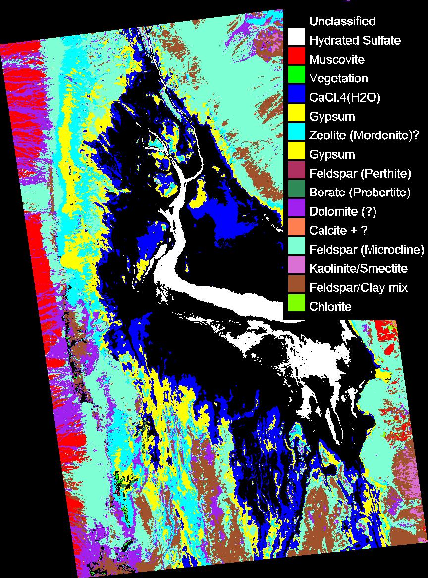
3 Supervised versus Unsupervised Classification n Unsupervised Classes are determined by the computer. Also referred to as clustering n Supervised Classes are specified by analyst, typically via extraction of spectra from training areas in the scene.
4

5 Supervised Classifications (all available in ENVI!) Parallelepiped
6 Minimum Distance


7 Minimum Distance Method
8 Maximum Likelihood
9 Maximum Likelihood
10 Spectral Angle Mapper
11 Spectral Angle Mapper

12 Unsupervised Techniques: K-Means n User specifies # of classes. Algorithm first assigns randomly distributed class centers in n-d space, clusters pixels according to min. distance. Next iteration, finds mean coordinates of clusters, uses these locations as new class centers and re-clusters by distance. Continues until means move less than a specified threshold between subsequent iterations. Most useful when you know the number of spectral units in a scene a priori, but don t necessarily know where they fall within the scene (so supervised techniques aren t possible).

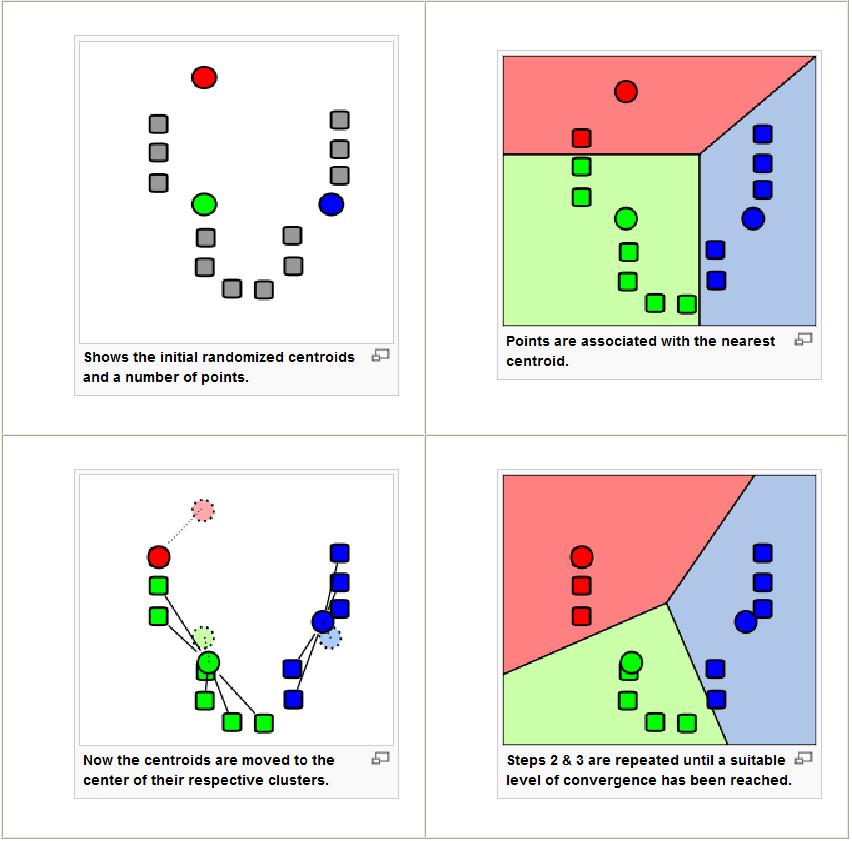
13 K-Means Demo:
14 Unsupervised Techniques: Isodata n Similar to K-means, except user doesn t need to specify number of classes. Algorithm starts with randomly spaced trial classes, calculates minimum distances to cluster all pixels in the scene. Before next iteration, algorithm looks at the statistics of each class to see if any should be split, merged, or deleted. Iterations continue until number of pixels in each class changes less than some threshold between iterations. Most useful when you don t have a clue how many spectral units are likely to be present in a scene.
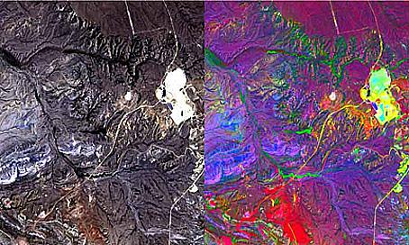
15 Correlated vs. Uncorrelated Data
16 3-Band Correlations in RGB Data only occupy a small fraction of the total colors available for display.
17 Intensity, Saturation, and Hue Most of the compositional information is in hue and saturation.
18 An HIS stretch usually involves converting RGB coordinates for pixels into measures of hue, intensity, and saturation. Intensity and saturation can be stretched to more completely fill color space. Often, another higher spatial resolution, monoor pan-chromatic band is used to replace the original intensity data. The lower resolution multispectral data are used to provide hue and saturation in the merged (or fused ) output image. Called Pan-sharpening.
19
20 Principal Component Analysis (PCA) Multispectral, and especially hyperspectral data have more information from more wavelengths than our brains can process! Often, one band is highly correlated with another PCA offers a way to reduce the inherent dimensionality of a multi- or hyperspectral dataset into the smallest number of independent dimensions Makes contrast enhancement of different classes much better
21 Principal Component Analysis (PCA) 1. Move origin of coordinate system to center (mean) of data cloud. 2. Find a rotation of axes that maximizes the variance of the data along the new orientations of the axes. 3. Stretch the data along the new axes to fill the color space points are no longer correlated.
22 PCA Terminology n Eigenvector: Describes the shift and orientation of the new axes. For n input bands, you get n output bands with n associated eigenvectors n Eigenvalue: Describes the magnitude of the variance along the new axes (prior to stretching). There is one eigenvalue for each axis.
 because higher-order axes don t contain as much independent")
23 PCA Advantages n PCA analysis can simultaneously consider all input bands. n Has the effect of reducing the dimensionality of the data (fewer # of bands contain most of the information) because higher-order axes don t contain as much independent (uncorrelated) information. n More completely fills the available color space when PCA bands are displayed in RGB triplets
24 PCA Disadvantages n Can be difficult to understand PCA bands in terms of composition no one-to-one correspondence between a particular PCA band and any one input band. Typically, PCA bands are used to map the spectral/ compositional units in a scene. Once the pixels belonging to a particular spectral unit have been identified, compositional identifications are made using spectra for those pixels extracted from the original input pixels (pre-pca).
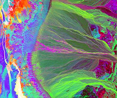
25 Decorrelation Stretching After performing a PCA rotation and stretching the data, the axes are rotated back to their original (input) orientations. Preserves original sense of color.
26
27
Data Fusion. Merging data from multiple sources to optimize data or create value added data
 Data Fusion Jeffrey S. Evans - Landscape Ecologist USDA Forest Service Rocky Mountain Research Station Forestry Sciences Lab - Moscow, Idaho Data Fusion Data Fusion is a formal framework in which are expressed
Data: a collection of numbers or facts that require further processing before they are meaningful
 Digital Image Classification Data vs. Information Data: a collection of numbers or facts that require further processing before they are meaningful Information: Derived knowledge from raw data. Something
ENVI Classic Tutorial: Multispectral Analysis of MASTER HDF Data 2
 ENVI Classic Tutorial: Multispectral Analysis of MASTER HDF Data Multispectral Analysis of MASTER HDF Data 2 Files Used in This Tutorial 2 Background 2 Shortwave Infrared (SWIR) Analysis 3 Opening the
Unsupervised Learning
 Unsupervised Learning Unsupervised learning Until now, we have assumed our training samples are labeled by their category membership. Methods that use labeled samples are said to be supervised. However,
INF 4300 Classification III Anne Solberg The agenda today:
 INF 4300 Classification III Anne Solberg 28.10.15 The agenda today: More on estimating classifier accuracy Curse of dimensionality and simple feature selection knn-classification K-means clustering 28.10.15
Image Analysis, Classification and Change Detection in Remote Sensing
 Image Analysis, Classification and Change Detection in Remote Sensing WITH ALGORITHMS FOR ENVI/IDL Morton J. Canty Taylor &. Francis Taylor & Francis Group Boca Raton London New York CRC is an imprint
CIE L*a*b* color model
 CIE L*a*b* color model To further strengthen the correlation between the color model and human perception, we apply the following non-linear transformation: with where (X n,y n,z n ) are the tristimulus
Network Traffic Measurements and Analysis
 DEIB - Politecnico di Milano Fall, 2017 Introduction Often, we have only a set of features x = x 1, x 2,, x n, but no associated response y. Therefore we are not interested in prediction nor classification,
Classification. Vladimir Curic. Centre for Image Analysis Swedish University of Agricultural Sciences Uppsala University
 Classification Vladimir Curic Centre for Image Analysis Swedish University of Agricultural Sciences Uppsala University Outline An overview on classification Basics of classification How to choose appropriate
Hyperspectral Remote Sensing
 Hyperspectral Remote Sensing Multi-spectral: Several comparatively wide spectral bands Hyperspectral: Many (could be hundreds) very narrow spectral bands GEOG 4110/5100 30 AVIRIS: Airborne Visible/Infrared
ENVI Classic Tutorial: Basic SAR Processing and Analysis
 ENVI Classic Tutorial: Basic SAR Processing and Analysis Basic SAR Processing and Analysis 2 Files Used in this Tutorial 2 Background 2 Single-Band SAR Processing 3 Read and Display RADARSAT CEOS Data
HYPERSPECTRAL REMOTE SENSING
 HYPERSPECTRAL REMOTE SENSING By Samuel Rosario Overview The Electromagnetic Spectrum Radiation Types MSI vs HIS Sensors Applications Image Analysis Software Feature Extraction Information Extraction 1
Introduction to digital image classification
 Introduction to digital image classification Dr. Norman Kerle, Wan Bakx MSc a.o. INTERNATIONAL INSTITUTE FOR GEO-INFORMATION SCIENCE AND EARTH OBSERVATION Purpose of lecture Main lecture topics Review
ENVI Tutorial: Vegetation Hyperspectral Analysis
 ENVI Tutorial: Vegetation Hyperspectral Analysis Table of Contents OVERVIEW OF THIS TUTORIAL...1 HyMap Processing Flow...4 VEGETATION HYPERSPECTRAL ANALYSIS...4 Examine the Jasper Ridge HyMap Radiance
Copyright 2005 Center for Imaging Science Rochester Institute of Technology Rochester, NY
 Development of Algorithm for Fusion of Hyperspectral and Multispectral Imagery with the Objective of Improving Spatial Resolution While Retaining Spectral Data Thesis Christopher J. Bayer Dr. Carl Salvaggio
CLASSIFICATION AND CHANGE DETECTION
 IMAGE ANALYSIS, CLASSIFICATION AND CHANGE DETECTION IN REMOTE SENSING With Algorithms for ENVI/IDL and Python THIRD EDITION Morton J. Canty CRC Press Taylor & Francis Group Boca Raton London NewYork CRC
ENVI Tutorial: Basic SAR Processing and Analysis
 ENVI Tutorial: Basic SAR Processing and Analysis Table of Contents OVERVIEW OF THIS TUTORIAL...2 Background...2 SINGLE-BAND SAR PROCESSING...3 Read and Display RADARSAT CEOS Data...3 Review CEOS Header...3
IMAGE ANALYSIS, CLASSIFICATION, and CHANGE DETECTION in REMOTE SENSING
 SECOND EDITION IMAGE ANALYSIS, CLASSIFICATION, and CHANGE DETECTION in REMOTE SENSING ith Algorithms for ENVI/IDL Morton J. Canty с*' Q\ CRC Press Taylor &. Francis Group Boca Raton London New York CRC
Color and Shading. Color. Shapiro and Stockman, Chapter 6. Color and Machine Vision. Color and Perception
 Color and Shading Color Shapiro and Stockman, Chapter 6 Color is an important factor for for human perception for object and material identification, even time of day. Color perception depends upon both
Region Based Image Fusion Using SVM
 Region Based Image Fusion Using SVM Yang Liu, Jian Cheng, Hanqing Lu National Laboratory of Pattern Recognition, Institute of Automation, Chinese Academy of Sciences ABSTRACT This paper presents a novel
DIGITAL IMAGE ANALYSIS. Image Classification: Object-based Classification
 DIGITAL IMAGE ANALYSIS Image Classification: Object-based Classification Image classification Quantitative analysis used to automate the identification of features Spectral pattern recognition Unsupervised
Classification. Vladimir Curic. Centre for Image Analysis Swedish University of Agricultural Sciences Uppsala University
 Classification Vladimir Curic Centre for Image Analysis Swedish University of Agricultural Sciences Uppsala University Outline An overview on classification Basics of classification How to choose appropriate
Region-based Segmentation
 Region-based Segmentation Image Segmentation Group similar components (such as, pixels in an image, image frames in a video) to obtain a compact representation. Applications: Finding tumors, veins, etc.
Copyright 2005 Society of Photo-Optical Instrumentation Engineers.
 Copyright 2005 Society of Photo-Optical Instrumentation Engineers. This paper was published in the Proceedings, SPIE Symposium on Defense & Security, 28 March 1 April, 2005, Orlando, FL, Conference 5806
A MAXIMUM NOISE FRACTION TRANSFORM BASED ON A SENSOR NOISE MODEL FOR HYPERSPECTRAL DATA. Naoto Yokoya 1 and Akira Iwasaki 2
 A MAXIMUM NOISE FRACTION TRANSFORM BASED ON A SENSOR NOISE MODEL FOR HYPERSPECTRAL DATA Naoto Yokoya 1 and Akira Iwasaki 1 Graduate Student, Department of Aeronautics and Astronautics, The University of
Files Used in This Tutorial. Background. Feature Extraction with Example-Based Classification Tutorial
 Feature Extraction with Example-Based Classification Tutorial In this tutorial, you will use Feature Extraction to extract rooftops from a multispectral QuickBird scene of a residential area in Boulder,
Dimension reduction : PCA and Clustering
 Dimension reduction : PCA and Clustering By Hanne Jarmer Slides by Christopher Workman Center for Biological Sequence Analysis DTU The DNA Array Analysis Pipeline Array design Probe design Question Experimental
CSE 40171: Artificial Intelligence. Learning from Data: Unsupervised Learning
 CSE 40171: Artificial Intelligence Learning from Data: Unsupervised Learning 32 Homework #6 has been released. It is due at 11:59PM on 11/7. 33 CSE Seminar: 11/1 Amy Reibman Purdue University 3:30pm DBART
( ) =cov X Y = W PRINCIPAL COMPONENT ANALYSIS. Eigenvectors of the covariance matrix are the principal components
 =cov X Y = W PRINCIPAL COMPONENT ANALYSIS. Eigenvectors of the covariance matrix are the principal components") Review Lecture 14 ! PRINCIPAL COMPONENT ANALYSIS Eigenvectors of the covariance matrix are the principal components 1. =cov X Top K principal components are the eigenvectors with K largest eigenvalues
Review Lecture 14 ! PRINCIPAL COMPONENT ANALYSIS Eigenvectors of the covariance matrix are the principal components 1. =cov X Top K principal components are the eigenvectors with K largest eigenvalues
ENVI Classic Tutorial: A Quick Start to ENVI Classic
 ENVI Classic Tutorial: A Quick Start to ENVI Classic A Quick Start to ENVI Classic 2 Files Used in this Tutorial 2 Getting Started with ENVI Classic 3 Loading a Gray Scale Image 3 Familiarizing Yourself
ENVI. Get the Information You Need from Imagery.
 Visual Information Solutions ENVI. Get the Information You Need from Imagery. ENVI is the premier software solution to quickly, easily, and accurately extract information from geospatial imagery. Easy
Remote Sensing & Photogrammetry W4. Beata Hejmanowska Building C4, room 212, phone:
 Remote Sensing & Photogrammetry W4 Beata Hejmanowska Building C4, room 212, phone: +4812 617 22 72 605 061 510 galia@agh.edu.pl 1 General procedures in image classification Conventional multispectral classification
CSE 158. Web Mining and Recommender Systems. Midterm recap
 CSE 158 Web Mining and Recommender Systems Midterm recap Midterm on Wednesday! 5:10 pm 6:10 pm Closed book but I ll provide a similar level of basic info as in the last page of previous midterms CSE 158
Assignment 2. Classification and Regression using Linear Networks, Multilayer Perceptron Networks, and Radial Basis Functions
 ENEE 739Q: STATISTICAL AND NEURAL PATTERN RECOGNITION Spring 2002 Assignment 2 Classification and Regression using Linear Networks, Multilayer Perceptron Networks, and Radial Basis Functions Aravind Sundaresan
INTERNATIONAL JOURNAL OF GEOMATICS AND GEOSCIENCES Volume 2, No 2, 2011
 INTERNATIONAL JOURNAL OF GEOMATICS AND GEOSCIENCES Volume 2, No 2, 2011 Copyright 2010 All rights reserved Integrated Publishing services Research article ISSN 076 480 Image fusion techniques for accurate
Lecture 11: Classification
 Lecture 11: Classification 1 2009-04-28 Patrik Malm Centre for Image Analysis Swedish University of Agricultural Sciences Uppsala University 2 Reading instructions Chapters for this lecture 12.1 12.2 in
ENVI Tutorial: Geologic Hyperspectral Analysis
 ENVI Tutorial: Geologic Hyperspectral Analysis Table of Contents OVERVIEW OF THIS TUTORIAL...2 Objectives...2 s Used in This Tutorial...2 PROCESSING FLOW...3 GEOLOGIC HYPERSPECTRAL ANALYSIS...4 Overview
Fast Edge Detection Using Structured Forests
 Fast Edge Detection Using Structured Forests Piotr Dollár, C. Lawrence Zitnick [1] Zhihao Li (zhihaol@andrew.cmu.edu) Computer Science Department Carnegie Mellon University Table of contents 1. Introduction
Principal Component Image Interpretation A Logical and Statistical Approach
 Principal Component Image Interpretation A Logical and Statistical Approach Md Shahid Latif M.Tech Student, Department of Remote Sensing, Birla Institute of Technology, Mesra Ranchi, Jharkhand-835215 Abstract
Image Classification. RS Image Classification. Present by: Dr.Weerakaset Suanpaga
 Image Classification Present by: Dr.Weerakaset Suanpaga D.Eng(RS&GIS) 6.1 Concept of Classification Objectives of Classification Advantages of Multi-Spectral data for Classification Variation of Multi-Spectra
Using Imagery for Intelligence Analysis
 2013 Esri International User Conference July 8 12, 2013 San Diego, California Technical Workshop Using Imagery for Intelligence Analysis Renee Bernstein Natalie Campos Esri UC2013. Technical Workshop.
Object-Based Classification & ecognition. Zutao Ouyang 11/17/2015
 Object-Based Classification & ecognition Zutao Ouyang 11/17/2015 What is Object-Based Classification The object based image analysis approach delineates segments of homogeneous image areas (i.e., objects)
Machine Learning Applications in Exploration and Mining
 Machine Learning Applications in Exploration and Mining Tom Carmichael, Brenton Crawford, Liam Webb. QEC - The role of data in discovery 28 th February 2018 www.solvegeosolutions.com Outline Where and
Biometrics Technology: Image Processing & Pattern Recognition (by Dr. Dickson Tong)
") Biometrics Technology: Image Processing & Pattern Recognition (by Dr. Dickson Tong) References: [1] http://homepages.inf.ed.ac.uk/rbf/hipr2/index.htm [2] http://www.cs.wisc.edu/~dyer/cs540/notes/vision.html
Biometrics Technology: Image Processing & Pattern Recognition (by Dr. Dickson Tong) References: [1] http://homepages.inf.ed.ac.uk/rbf/hipr2/index.htm [2] http://www.cs.wisc.edu/~dyer/cs540/notes/vision.html
Analysis of Functional MRI Timeseries Data Using Signal Processing Techniques
 Analysis of Functional MRI Timeseries Data Using Signal Processing Techniques Sea Chen Department of Biomedical Engineering Advisors: Dr. Charles A. Bouman and Dr. Mark J. Lowe S. Chen Final Exam October
CS325 Artificial Intelligence Ch. 20 Unsupervised Machine Learning
 CS325 Artificial Intelligence Cengiz Spring 2013 Unsupervised Learning Missing teacher No labels, y Just input data, x What can you learn with it? Unsupervised Learning Missing teacher No labels, y Just
IMAGE PROCESSING >FILTERS AND EDGE DETECTION FOR COLOR IMAGES UTRECHT UNIVERSITY RONALD POPPE
 IMAGE PROCESSING >FILTERS AND EDGE DETECTION FOR COLOR IMAGES UTRECHT UNIVERSITY RONALD POPPE OUTLINE Filters for color images Edge detection for color images Canny edge detection FILTERS FOR COLOR IMAGES
Classifying Images with Visual/Textual Cues. By Steven Kappes and Yan Cao
 Classifying Images with Visual/Textual Cues By Steven Kappes and Yan Cao Motivation Image search Building large sets of classified images Robotics Background Object recognition is unsolved Deformable shaped
Cluster Analysis. Mu-Chun Su. Department of Computer Science and Information Engineering National Central University 2003/3/11 1
 Cluster Analysis Mu-Chun Su Department of Computer Science and Information Engineering National Central University 2003/3/11 1 Introduction Cluster analysis is the formal study of algorithms and methods
CSE 258 Lecture 5. Web Mining and Recommender Systems. Dimensionality Reduction
 CSE 258 Lecture 5 Web Mining and Recommender Systems Dimensionality Reduction This week How can we build low dimensional representations of high dimensional data? e.g. how might we (compactly!) represent
COSC160: Detection and Classification. Jeremy Bolton, PhD Assistant Teaching Professor
 COSC160: Detection and Classification Jeremy Bolton, PhD Assistant Teaching Professor Outline I. Problem I. Strategies II. Features for training III. Using spatial information? IV. Reducing dimensionality
Unsupervised Learning
 Networks for Pattern Recognition, 2014 Networks for Single Linkage K-Means Soft DBSCAN PCA Networks for Kohonen Maps Linear Vector Quantization Networks for Problems/Approaches in Machine Learning Supervised
Probably 3 Questions Each on:
 Probably 3 Questions Each on: 1. Radiometric Enhancement 2. Geometric Enhancement 3. Temperature Retrieval 4. The Frequency Domain 5. Classification 6. Principal Component Analysis (PCA) Effects of the
Raster Classification with ArcGIS Desktop. Rebecca Richman Andy Shoemaker
 Raster Classification with ArcGIS Desktop Rebecca Richman Andy Shoemaker Raster Classification What is it? - Classifying imagery into different land use/ land cover classes based on the pixel values of
ECG782: Multidimensional Digital Signal Processing
 Professor Brendan Morris, SEB 3216, brendan.morris@unlv.edu ECG782: Multidimensional Digital Signal Processing Spring 2014 TTh 14:30-15:45 CBC C313 Lecture 06 Image Structures 13/02/06 http://www.ee.unlv.edu/~b1morris/ecg782/
COMPARATIVE STUDY OF IMAGE FUSION TECHNIQUES IN SPATIAL AND TRANSFORM DOMAIN
 COMPARATIVE STUDY OF IMAGE FUSION TECHNIQUES IN SPATIAL AND TRANSFORM DOMAIN Bhuvaneswari Balachander and D. Dhanasekaran Department of Electronics and Communication Engineering, Saveetha School of Engineering,
Lab 9. Julia Janicki. Introduction
 Lab 9 Julia Janicki Introduction My goal for this project is to map a general land cover in the area of Alexandria in Egypt using supervised classification, specifically the Maximum Likelihood and Support
8. Clustering: Pattern Classification by Distance Functions
 CEE 6: Digital Image Processing Topic : Clustering/Unsupervised Classification - W. Philpot, Cornell University, January 0. Clustering: Pattern Classification by Distance Functions The premise in clustering
A Method for Edge Detection in Hyperspectral Images Based on Gradient Clustering
 A Method for Edge Detection in Hyperspectral Images Based on Gradient Clustering V.C. Dinh, R. P. W. Duin Raimund Leitner Pavel Paclik Delft University of Technology CTR AG PR Sys Design The Netherlands
Case-Based Reasoning. CS 188: Artificial Intelligence Fall Nearest-Neighbor Classification. Parametric / Non-parametric.
 CS 188: Artificial Intelligence Fall 2008 Lecture 25: Kernels and Clustering 12/2/2008 Dan Klein UC Berkeley Case-Based Reasoning Similarity for classification Case-based reasoning Predict an instance
CS 188: Artificial Intelligence Fall 2008
 CS 188: Artificial Intelligence Fall 2008 Lecture 25: Kernels and Clustering 12/2/2008 Dan Klein UC Berkeley 1 1 Case-Based Reasoning Similarity for classification Case-based reasoning Predict an instance
CSE 255 Lecture 5. Data Mining and Predictive Analytics. Dimensionality Reduction
 CSE 255 Lecture 5 Data Mining and Predictive Analytics Dimensionality Reduction Course outline Week 4: I ll cover homework 1, and get started on Recommender Systems Week 5: I ll cover homework 2 (at the
Hyperspectral Chemical Imaging: principles and Chemometrics.
 Hyperspectral Chemical Imaging: principles and Chemometrics aoife.gowen@ucd.ie University College Dublin University College Dublin 1,596 PhD students 6,17 international students 8,54 graduate students
Spatially variant dimensionality reduction for the visualization of multi/hyperspectral images
 Author manuscript, published in "International Conference on Image Analysis and Recognition, Burnaby : Canada (2011)" DOI : 10.1007/978-3-642-21593-3_38 Spatially variant dimensionality reduction for the
Lecture 11: E-M and MeanShift. CAP 5415 Fall 2007
 Lecture 11: E-M and MeanShift CAP 5415 Fall 2007 Review on Segmentation by Clustering Each Pixel Data Vector Example (From Comanciu and Meer) Review of k-means Let's find three clusters in this data These
A Vector Agent-Based Unsupervised Image Classification for High Spatial Resolution Satellite Imagery
 A Vector Agent-Based Unsupervised Image Classification for High Spatial Resolution Satellite Imagery K. Borna 1, A. B. Moore 2, P. Sirguey 3 School of Surveying University of Otago PO Box 56, Dunedin,
(Refer Slide Time: 0:51)
") Introduction to Remote Sensing Dr. Arun K Saraf Department of Earth Sciences Indian Institute of Technology Roorkee Lecture 16 Image Classification Techniques Hello everyone welcome to 16th lecture in
Introduction to Remote Sensing Dr. Arun K Saraf Department of Earth Sciences Indian Institute of Technology Roorkee Lecture 16 Image Classification Techniques Hello everyone welcome to 16th lecture in
Clustering & Dimensionality Reduction. 273A Intro Machine Learning
 Clustering & Dimensionality Reduction 273A Intro Machine Learning What is Unsupervised Learning? In supervised learning we were given attributes & targets (e.g. class labels). In unsupervised learning
PRINCIPAL components analysis (PCA) is a widely
 is a widely") 1586 IEEE TRANSACTIONS ON GEOSCIENCE AND REMOTE SENSING, VOL. 44, NO. 6, JUNE 2006 Independent Component Analysis-Based Dimensionality Reduction With Applications in Hyperspectral Image Analysis Jing Wang,
1586 IEEE TRANSACTIONS ON GEOSCIENCE AND REMOTE SENSING, VOL. 44, NO. 6, JUNE 2006 Independent Component Analysis-Based Dimensionality Reduction With Applications in Hyperspectral Image Analysis Jing Wang,
Modern Medical Image Analysis 8DC00 Exam
 Parts of answers are inside square brackets [... ]. These parts are optional. Answers can be written in Dutch or in English, as you prefer. You can use drawings and diagrams to support your textual answers.
Classify Multi-Spectral Data Classify Geologic Terrains on Venus Apply Multi-Variate Statistics
 Classify Multi-Spectral Data Classify Geologic Terrains on Venus Apply Multi-Variate Statistics Operations What Do I Need? Classify Merge Combine Cross Scan Score Warp Respace Cover Subscene Rotate Translators
Implementation & comparative study of different fusion techniques (WAVELET, IHS, PCA)
") International Refereed Journal of Engineering and Science (IRJES) ISSN (Online) 2319-183X, (Print) 2319-1821 Volume 1, Issue 4(December 2012), PP.37-41 Implementation & comparative study of different fusion
International Refereed Journal of Engineering and Science (IRJES) ISSN (Online) 2319-183X, (Print) 2319-1821 Volume 1, Issue 4(December 2012), PP.37-41 Implementation & comparative study of different fusion
Figure 1: Workflow of object-based classification
 Technical Specifications Object Analyst Object Analyst is an add-on package for Geomatica that provides tools for segmentation, classification, and feature extraction. Object Analyst includes an all-in-one
Remote Sensing Introduction to the course
 Remote Sensing Introduction to the course Remote Sensing (Prof. L. Biagi) Exploitation of remotely assessed data for information retrieval Data: Digital images of the Earth, obtained by sensors recording
Clustering. CS294 Practical Machine Learning Junming Yin 10/09/06
 Clustering CS294 Practical Machine Learning Junming Yin 10/09/06 Outline Introduction Unsupervised learning What is clustering? Application Dissimilarity (similarity) of objects Clustering algorithm K-means,
Pattern recognition. Classification/Clustering GW Chapter 12 (some concepts) Textures
 Textures") Pattern recognition Classification/Clustering GW Chapter 12 (some concepts) Textures Patterns and pattern classes Pattern: arrangement of descriptors Descriptors: features Patten class: family of patterns
Pattern recognition Classification/Clustering GW Chapter 12 (some concepts) Textures Patterns and pattern classes Pattern: arrangement of descriptors Descriptors: features Patten class: family of patterns
Salient Pixels and Dimensionality Reduction for Display of Multi/Hyperspectral Images
 Salient Pixels and Dimensionality Reduction for Display of Multi/Hyperspectral Images Steven Le Moan 1,2, Ferdinand Deger 1,2, Alamin Mansouri 1, Yvon Voisin 1,andJonY.Hardeberg 2 1 Laboratoire d Electronique,
Recognition: Face Recognition. Linda Shapiro EE/CSE 576
 Recognition: Face Recognition Linda Shapiro EE/CSE 576 1 Face recognition: once you ve detected and cropped a face, try to recognize it Detection Recognition Sally 2 Face recognition: overview Typical
ENVI Classic Tutorial: 3D SurfaceView and Fly- Through
 ENVI Classic Tutorial: 3D SurfaceView and Fly- Through 3D SurfaceView and Fly-Through 2 Files Used in this Tutorial 2 3D Visualization in ENVI Classic 2 Load a 3D SurfaceView 3 Open and Display Landsat
Fundamentals of Digital Image Processing
 \L\.6 Gw.i Fundamentals of Digital Image Processing A Practical Approach with Examples in Matlab Chris Solomon School of Physical Sciences, University of Kent, Canterbury, UK Toby Breckon School of Engineering,
10/14/2017. Dejan Sarka. Anomaly Detection. Sponsors
 Dejan Sarka Anomaly Detection Sponsors About me SQL Server MVP (17 years) and MCT (20 years) 25 years working with SQL Server Authoring 16 th book Authoring many courses, articles Agenda Introduction Simple
Unsupervised and Self-taught Learning for Remote Sensing Image Analysis
 Unsupervised and Self-taught Learning for Remote Sensing Image Analysis Ribana Roscher Institute of Geodesy and Geoinformation, Remote Sensing Group, University of Bonn 1 The Changing Earth https://earthengine.google.com/timelapse/
Clustering and The Expectation-Maximization Algorithm
 Clustering and The Expectation-Maximization Algorithm Unsupervised Learning Marek Petrik 3/7 Some of the figures in this presentation are taken from An Introduction to Statistical Learning, with applications
Spatializing GIS Commands with Self-Organizing Maps. Jochen Wendel Barbara P. Buttenfield Roland J. Viger Jeremy M. Smith
 Spatializing GIS Commands with Self-Organizing Maps Jochen Wendel Barbara P. Buttenfield Roland J. Viger Jeremy M. Smith Outline Introduction Characterizing GIS Commands Implementation Interpretation of
APPLICATION OF SOFTMAX REGRESSION AND ITS VALIDATION FOR SPECTRAL-BASED LAND COVER MAPPING
 APPLICATION OF SOFTMAX REGRESSION AND ITS VALIDATION FOR SPECTRAL-BASED LAND COVER MAPPING J. Wolfe a, X. Jin a, T. Bahr b, N. Holzer b, * a Harris Corporation, Broomfield, Colorado, U.S.A. (jwolfe05,
ISSN Vol.03,Issue.14 June-2014, Pages:
 www.semargroup.org, www.ijsetr.com ISSN 2319-8885 Vol.03,Issue.14 June-2014, Pages:3012-3017 Comparison between Edge Detection and K-Means Clustering Methods for Image Segmentation and Merging HNIN MAR
Statistical Analysis of Metabolomics Data. Xiuxia Du Department of Bioinformatics & Genomics University of North Carolina at Charlotte
 Statistical Analysis of Metabolomics Data Xiuxia Du Department of Bioinformatics & Genomics University of North Carolina at Charlotte Outline Introduction Data pre-treatment 1. Normalization 2. Centering,
Machine learning Pattern recognition. Classification/Clustering GW Chapter 12 (some concepts) Textures
 Textures") Machine learning Pattern recognition Classification/Clustering GW Chapter 12 (some concepts) Textures Patterns and pattern classes Pattern: arrangement of descriptors Descriptors: features Patten class:
Machine learning Pattern recognition Classification/Clustering GW Chapter 12 (some concepts) Textures Patterns and pattern classes Pattern: arrangement of descriptors Descriptors: features Patten class:
Prof. Fanny Ficuciello Robotics for Bioengineering Visual Servoing
 Visual servoing vision allows a robotic system to obtain geometrical and qualitative information on the surrounding environment high level control motion planning (look-and-move visual grasping) low level
By Colin Childs, ESRI Education Services. Catalog
 s resolve many traditional raster management issues By Colin Childs, ESRI Education Services Source images ArcGIS 10 introduces Catalog Mosaicked images Sources, mosaic methods, and functions are used
ECG782: Multidimensional Digital Signal Processing
 Professor Brendan Morris, SEB 3216, brendan.morris@unlv.edu ECG782: Multidimensional Digital Signal Processing Spring 2014 TTh 14:30-15:45 CBC C313 Lecture 10 Segmentation 14/02/27 http://www.ee.unlv.edu/~b1morris/ecg782/
Histogram and watershed based segmentation of color images
 Histogram and watershed based segmentation of color images O. Lezoray H. Cardot LUSAC EA 2607 IUT Saint-Lô, 120 rue de l'exode, 50000 Saint-Lô, FRANCE Abstract A novel method for color image segmentation
MRO CRISM TRR3 Hyperspectral Data Filtering
 MRO CRISM TRR3 Hyperspectral Data Filtering CRISM Data User's Workshop 03/18/12 F. Seelos, CRISM SOC CRISM PDS-Delivered VNIR TRR3 I/F 3-Panel Plot False Color RGB Composite Composite band distribution
Digital Image Classification Geography 4354 Remote Sensing
 Digital Image Classification Geography 4354 Remote Sensing Lab 11 Dr. James Campbell December 10, 2001 Group #4 Mark Dougherty Paul Bartholomew Akisha Williams Dave Trible Seth McCoy Table of Contents:
Fast Sample Generation with Variational Bayesian for Limited Data Hyperspectral Image Classification
 Fast Sample Generation with Variational Bayesian for Limited Data Hyperspectral Image Classification July 26, 2018 AmirAbbas Davari, Hasan Can Özkan, Andreas Maier, Christian Riess Pattern Recognition
CSE 158 Lecture 6. Web Mining and Recommender Systems. Community Detection
 CSE 158 Lecture 6 Web Mining and Recommender Systems Community Detection Dimensionality reduction Goal: take high-dimensional data, and describe it compactly using a small number of dimensions Assumption:
Large-Scale Face Manifold Learning
 Large-Scale Face Manifold Learning Sanjiv Kumar Google Research New York, NY * Joint work with A. Talwalkar, H. Rowley and M. Mohri 1 Face Manifold Learning 50 x 50 pixel faces R 2500 50 x 50 pixel random
CSE 255 Lecture 6. Data Mining and Predictive Analytics. Community Detection
 CSE 255 Lecture 6 Data Mining and Predictive Analytics Community Detection Dimensionality reduction Goal: take high-dimensional data, and describe it compactly using a small number of dimensions Assumption:
CHAPTER 3 PRINCIPAL COMPONENT ANALYSIS AND FISHER LINEAR DISCRIMINANT ANALYSIS
 38 CHAPTER 3 PRINCIPAL COMPONENT ANALYSIS AND FISHER LINEAR DISCRIMINANT ANALYSIS 3.1 PRINCIPAL COMPONENT ANALYSIS (PCA) 3.1.1 Introduction In the previous chapter, a brief literature review on conventional
Hyperspectral Image Enhancement Based on Sensor Simulation and Vector Decomposition
 Hyperspectral Image Enhancement Based on Sensor Simulation and Vector Decomposition Ankush Khandelwal Lab for Spatial Informatics International Institute of Information Technology Hyderabad, India ankush.khandelwal@research.iiit.ac.in