Using Mobile LiDAR To Efficiently Collect Roadway Asset and Condition Data. Pierre-Paul Grondin, B.Sc. Surveying
|
|
|
- Dylan Lawson
- 6 years ago
- Views:
Transcription


1 Using Mobile LiDAR To Efficiently Collect Roadway Asset and Condition Data Pierre-Paul Grondin, B.Sc. Surveying
2 LIDAR (Light Detection and Ranging) The prevalent method to determine distance to an object or surface is to use laser pulses. Like the similar radar technology (Radio detection and Ranging), which uses radio waves instead of light, the range to an object is determined by measuring the time delay between transmission of a pulse and detection of the reflected signal.
3 Primary difference between LiDAR and radar: LiDAR uses much shorter wavelengths of the electromagnetic spectrum, typically in the ultraviolet, visible, or near infrared.
4 Why LiDAR and not RADAR At radar frequencies, a metallic object produces a significant reflection while non-metallic objects produce weak reflections; some materials may produce no detectable reflection at all. Lasers provide a solution to these problems because of the beam densities and coherency + wavelengths are much smaller and are therefore reflected very well from small objects.
5 LiDARs used in mapping are eye-safe. When not, they incorporate preprogrammed safety functions.


6 One Technology Same technology as that used for airborne applications
7 One Technology 2D (dynamic) or 3D (static) Range in mobile mapping Generally 30 m to 100 m Reigl Q-240 Terrestrial/Airborne 450 m App points/sec Accuracy Generally +/- 1 inch Final accuracy greatly enhanced due to nb of pts
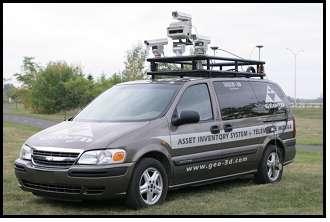
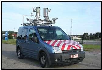


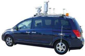
8 Data acquisition One Technology, Multiple Applications Mobile Mapping and Inventory Vehicles
9 Mobile mapping + lidar Why? Inventory Method Feet on the Street Historical Records Ortho Photography Mobile Mapping + LiDAR Safety Efficiency Complete ness Accuracy Low-Med Low High Med-High High Low Low Low High High Low Med-High High High High High Cost $$$$ $ $$$ $

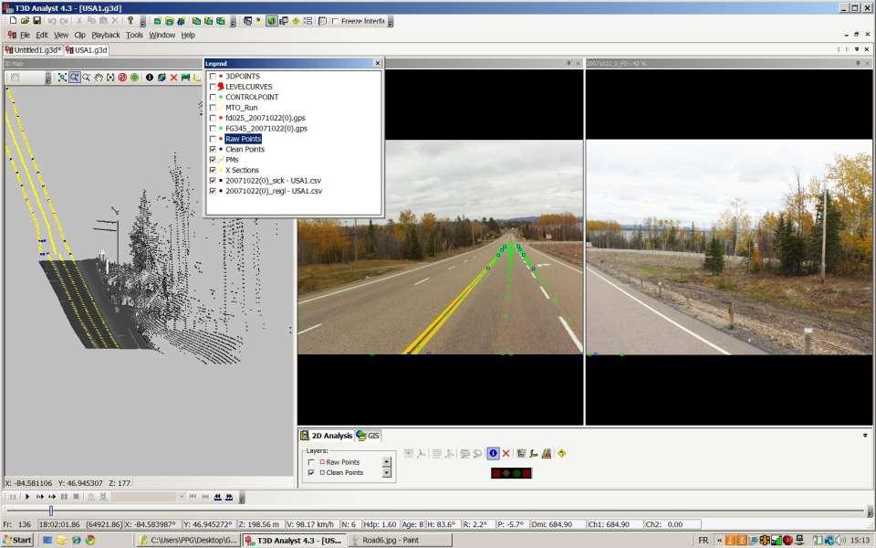
10 Mobile mapping + lidar Process Capture Convert Post Processing Optional for greater accuracy Analyst Office Analysis Manual/Automated Asset Extraction End Use GIS Asset Management Image Viewing Database/Tabular Data Acquisition Field Data Collection

11 DATA ACQUISITION 2D Laser Scanning

12 DATA ACQUISITION 2D Laser Scanning

13 DATA ACQUISITION 2D Laser Scanning

14 DATA ACQUISITION 2D Laser Scanning
15 OFFICE ANALYSIS Common issues in mobile mapping: Accuracy and Error Budget Raw GPS Errors Camera and Lens Errors Vehicle Lever Arm Errors Photogrammetric Errors Synchronization Errors Real time GPS and RTK corrections GPS post processing Precise lens calibration Precise measurement of lever arms On the fly QA & QC Integration of high resolution cameras Robust photogrammetric engine Precise synchronization of devices using PPS signal Multiplexer
 Object reflectivity Automation of: Location Measurements")
16 Office Analysis Automated Asset Detection Key data returned by laser: Coordinates (position) Object reflectivity Automation of: Location Measurements Recognition

17 Office analysis Automated Asset Detection Assets distinguished from surrounding environment Achieved through the use of: Filters Spatial Analysis Dynamic Parameters Reflectivity Analysis
18 SOME APPLICATIONS

19 Applications Automation Automation Focus on infrastructure related to safety o Signs o Pavement Markings o Road Geometry o Poles o Guiderails

20 applications Automated Sign Detection Every point has a 3D coordinate and a reflectivity value They enable the calculation of the position and size Reflective value does not meet MUTCD standards but...

21 applications Automated Sign Recognition Sign recognition is analyzed through comparison to sign library Recognition requires editing at the moment v


22 applications Automation Results Study Verification 23.7 miles surveyed 16 false detections 416 signs detected, located, and measured 1 missed sign Processing time ~ 90 seconds Final production including QA/QC: 416 signs in 45 mins
 o Vertical clearances o Capital improvement studies o Historical records Pavement / Shoulder Imaging o Image rectification for general condition")
23 Applications Trident 3D Solution Road Geometry o Road cross fall o Vertical / horizontal alignments o Road centerlines Corridor Assessments o Infrastructure offsets (encroachment) o Vertical clearances o Capital improvement studies o Historical records Pavement / Shoulder Imaging o Image rectification for general condition rating
24
25
26
27
28
29
30
31

32 Applications Image Rectification

33 applications Utility Modeling

34 applications Utility Measurements Pole Heights Connection Heights Cable Clearances Cable Separations Clearance Measurements 8 m

35 Pole Detection
36 BENEFITS
37 TRIDent-3D Solution Benefits Safety Efficiency Simplicity Completeness Accuracy Scalable No workers on the roadside: does not hinder traffic Data processing at a desktop level Faster than conventional data collection methods Rapid access to data Reduced operational costs Generally user friendly interfaces Click of the button in most cases Real time QA/QC in field and office settings Field re-visits can be done from a desktop Data is available at all times Depending on equipment, location referencing provides good absolute accuracy and very good relative accuracy Open, modular, and portable solution Coupled closely to GIS and Asset Management Systems
38
39
40

41
Aerial and Mobile LiDAR Data Fusion
 Creating Value Delivering Solutions Aerial and Mobile LiDAR Data Fusion Dr. Srini Dharmapuri, CP, PMP What You Will Learn About LiDAR Fusion Mobile and Aerial LiDAR Technology Components & Parameters Project
Microwave. Infrared. Preprogrammed Chip
 Advanced Technology for Design Mapping and Construction Layout AACE A.A.C.E. Meeting August 5, 2009 Daniel K. Mardock RBF Consulting Survey Manager Registered Land Surveyor Certified Federal Surveyor Arizona
Mobile LiDAR for Ground Applications. Spar 2006, March Paul Mrstik, Terrapoint Canada Inc. Craig Glennie, Terrapoint USA LLC
 Mobile LiDAR for Ground Applications Spar 2006, March 27 2006 Paul Mrstik, Terrapoint Canada Inc. Craig Glennie, Terrapoint USA LLC Agenda Introduction to Terrapoint What is mobile LiDAR? Advantages of
Mobile Mapping Solutions for Ohio s Integrated Transportation Network. Brian Foster, CP
 Mobile Mapping Solutions for Ohio s Integrated Transportation Network Brian Foster, CP About Woolpert Established in 1911 Over 600 Professionals 25 Offices $12,000,000 invested in new technology in last
Minnesota Department of Transportation Metro Barrier Extraction and LiDAR Project
 Minnesota Department of Transportation Metro Barrier Extraction and LiDAR Project Trisha Stefanksi, Primary Author Minnesota Department of Transportation June 2014 Research Project Final Report 2014-22
Georeferencing West Virginia DOT s Roadside Assets: An Asset Inventory Case Study. Geoff Dew April 13,
 : An Asset Inventory Case Study Geoff Dew April 13, 2010 General Project Scope 17,817 miles collected across all systems. System Type Delivered Miles 1 Interstates 1100.820 2 US Routes 2184.538 3 WV Routes
GeoSmart Asia Locate 18
 MOBILE MAPPING GeoSmart Asia Locate 18 ESP Associates, P.A. ESP Associates, P.A. ABOUT ESP Founded in 1986 (28 Years of Experience with DOT s) ESP has 14 offices throughout the US 37 States, Canada, and
Paul DiGiacobbe, PE, DBIA MASER Consulting Ryan Putt, PE HNTB Corporation Kevin Poad, PE HNTB Corporation
 Paul DiGiacobbe, PE, DBIA MASER Consulting Ryan Putt, PE HNTB Corporation Kevin Poad, PE HNTB Corporation Introduction Using LiDAR to Manage Safety Assets SPEED the acquisition phase is being performed
Critical Assessment of Automatic Traffic Sign Detection Using 3D LiDAR Point Cloud Data
 1 2 3 4 5 6 7 8 9 10 11 12 13 14 15 16 17 18 19 Critical Assessment of Automatic Traffic Sign Detection Using 3D LiDAR Point Cloud Data Chengbo Ai PhD Student School of Civil and Environmental Engineering
A New Way to Control Mobile LiDAR Data
 A New Way to Control Mobile LiDAR Data Survey control has always been a critically important issue when conducting mobile LiDAR surveys. While the accuracies currently being achieved with the most capable
A New Direction in GIS Data Collection or Why Are You Still in the Field?
 GeoAutomation The Mobile Mapping System Survey-Enabled Imagery A New Direction in GIS Data Collection or Why Are You Still in the Field? Presentation to: URISA BC GIS Technology Showcase January 19, 2011
Terrestrial GPS setup Fundamentals of Airborne LiDAR Systems, Collection and Calibration. JAMIE YOUNG Senior Manager LiDAR Solutions
 Terrestrial GPS setup Fundamentals of Airborne LiDAR Systems, Collection and Calibration JAMIE YOUNG Senior Manager LiDAR Solutions Topics Terrestrial GPS reference Planning and Collection Considerations
Commercial suas The Right Tool for the Right Job
 Commercial suas The Right Tool for the Right Job Presentation Objectives Overview of current data collection technologies UAS Systems Overview Surveyor 2.0 Project Case Study Mobile LiDAR & suas How Do
LIDAR MAPPING FACT SHEET
 1. LIDAR THEORY What is lidar? Lidar is an acronym for light detection and ranging. In the mapping industry, this term is used to describe an airborne laser profiling system that produces location and
The Application of Lasers to determine Structure Gauge Encroachments
 David Petterson The Application of Lasers to determine Structure Gauge Encroachments. Page 1. The Application of Lasers to determine Structure Gauge Encroachments Biography David Petterson, B. Geomatics,
Trimble Geospatial Division Integrated Solutions for Geomatics professions. Volker Zirn Regional Sales Representative
 Trimble Geospatial Division Integrated Solutions for Geomatics professions Volker Zirn Regional Sales Representative 1 Agenda Trimble GeoSpatial Division Airborne System Solutions Trimble Inpho Software
TLS Parameters, Workflows and Field Methods
 TLS Parameters, Workflows and Field Methods Marianne Okal, UNAVCO June 20 th, 2014 How a Lidar instrument works (Recap) Transmits laser signals and measures the reflected light to create 3D point clouds.
ENY-C2005 Geoinformation in Environmental Modeling Lecture 4b: Laser scanning
 1 ENY-C2005 Geoinformation in Environmental Modeling Lecture 4b: Laser scanning Petri Rönnholm Aalto University 2 Learning objectives To recognize applications of laser scanning To understand principles
ROAD-SCANNER COMPACT APPLICATION FIELDS MAIN FEATURES
 ROAD-SCANNER COMPACT Mobile Mapping System by GEXCEL & SITECO collaboration A smaller mobile system for asset management and cartography suited for ZOLLER & FRÖHLICH PROFILER 9012 laser scanner. 2 + 3
Integrated Multi-Source LiDAR and Imagery
 Figure 1: AirDaC aerial scanning system Integrated Multi-Source LiDAR and Imagery The derived benefits of LiDAR scanning in the fields of engineering, surveying, and planning are well documented. It has
An Overview of Applanix.
 An Overview of Applanix The Company The Industry Leader in Developing Aided Inertial Technology Founded on Canadian Aerospace and Defense Industry Expertise Providing Precise Position and Orientation Systems
2-4 April 2019 Taets Art and Event Park, Amsterdam CLICK TO KNOW MORE
 Co-Host Host 2-4 April 2019 Taets Art and Event Park, Amsterdam CLICK TO KNOW MORE Presentation Outline review modern survey methodologies available to support railway requirements measuring everything
Course Outline (1) #6 Data Acquisition for Built Environment. Fumio YAMAZAKI
 #6 Data Acquisition for Built Environment. Fumio YAMAZAKI") AT09.98 Applied GIS and Remote Sensing for Disaster Mitigation #6 Data Acquisition for Built Environment 9 October, 2002 Fumio YAMAZAKI yamazaki@ait.ac.th http://www.star.ait.ac.th/~yamazaki/ Course Outline
AT09.98 Applied GIS and Remote Sensing for Disaster Mitigation #6 Data Acquisition for Built Environment 9 October, 2002 Fumio YAMAZAKI yamazaki@ait.ac.th http://www.star.ait.ac.th/~yamazaki/ Course Outline
Pathway Services Inc. Technology Presentation
 Lauren Tran Budapest, Hungary 2015 Largest Vendor of this kind in the U.S. Largest Fleet of Full Service Vehicles in U.S. (26) More Than 5 Million Kilometers Collected Using Our Equipment Nearly 50% of
Jeffrey A. Schepers P.S. EIT Geospatial Services Holland Engineering Inc. 220 Hoover Blvd, Suite 2, Holland, MI Desk
 Jeffrey A. Schepers P.S. EIT Geospatial Services Holland Engineering Inc. 220 Hoover Blvd, Suite 2, Holland, MI 49423 616-594-5127 Desk 616-322-1724 Cell 616-392-5938 Office Mobile LiDAR - Laser Scanning
2/9/2016. Session Agenda: Implementing new Geospatial Technologies for more efficient data capture
 Implementing new Geospatial Technologies for more efficient data capture Jay Haskamp Applied Geospatial Engineer Steve Richter VP Sales Session Agenda: Today s changing technologies and what lies ahead
Case Study for Long- Range Beyond Visual Line of Sight Project. March 15, 2018 RMEL Transmission and Planning Conference
 Case Study for Long- Range Beyond Visual Line of Sight Project March 15, 2018 RMEL Transmission and Planning Conference 2014 HDR Architecture, 2016 2014 HDR, Inc., all all rights reserved. Helicopters
IP-S2 HD. High Definition 3D Mobile Mapping System
 IP-S2 HD High Definition 3D Mobile Mapping System Integrated, turnkey solution Georeferenced, Time-Stamped, Point Clouds and Imagery High Density, Long Range LiDAR sensor for ultimate in visual detail
Airborne Laser Scanning: Remote Sensing with LiDAR
 Airborne Laser Scanning: Remote Sensing with LiDAR ALS / LIDAR OUTLINE Laser remote sensing background Basic components of an ALS/LIDAR system Two distinct families of ALS systems Waveform Discrete Return
Terrain Modeling and Mapping for Telecom Network Installation Using Scanning Technology. Maziana Muhamad
 Terrain Modeling and Mapping for Telecom Network Installation Using Scanning Technology Maziana Muhamad Summarising LiDAR (Airborne Laser Scanning) LiDAR is a reliable survey technique, capable of: acquiring
Trimble MX2 mobile mapping
 Trimble MX2 mobile mapping user applications Point clouds within your reach The Trimble MX2 is a vehicle-mounted spatial imaging system which combines high resolution laser scanning and panoramic cameras
2/19/2018. Who are we? Who am I? What is Scanning? How does scanning work? How does scanning work? Scanning for Today s Surveyors
 2/19/2018 Who are we? Scanning for Today s Surveyors Survey, GIS, and Construction dealer Founded in 1988 Employee Owned Headquartered in Bismarck, ND States covered: ND, SD, MN, MT, WY, CO, UT, ID, WA,
Lecture 11. LiDAR, RADAR
 NRMT 2270, Photogrammetry/Remote Sensing Lecture 11 Calculating the Number of Photos and Flight Lines in a Photo Project LiDAR, RADAR Tomislav Sapic GIS Technologist Faculty of Natural Resources Management
Light Detection and Ranging (LiDAR)
") Light Detection and Ranging (LiDAR) http://code.google.com/creative/radiohead/ Types of aerial sensors passive active 1 Active sensors for mapping terrain Radar transmits microwaves in pulses determines
Light Detection and Ranging (LiDAR) http://code.google.com/creative/radiohead/ Types of aerial sensors passive active 1 Active sensors for mapping terrain Radar transmits microwaves in pulses determines
DO YOU NEED TO MEASURE OVERHEAD STRUCTURES?
 DO YOU NEED TO MEASURE OVERHEAD STRUCTURES? THE RSA LASER HEIGHT POLE WILL ALLOW YOU TO COLLECT THESE MEASUREMENTS AT HIGHWAY SPEEDS FROM THE COMFORT OF YOUR VEHICLE! April 15, 2015, President of RSA Network
ROAD SURFACE STRUCTURE MONITORING AND ANALYSIS USING HIGH PRECISION GPS MOBILE MEASUREMENT SYSTEMS (MMS)
") ROAD SURFACE STRUCTURE MONITORING AND ANALYSIS USING HIGH PRECISION GPS MOBILE MEASUREMENT SYSTEMS (MMS) Bonifacio R. Prieto PASCO Philippines Corporation, Pasig City, 1605, Philippines Email: bonifacio_prieto@pascoph.com
ROAD SURFACE STRUCTURE MONITORING AND ANALYSIS USING HIGH PRECISION GPS MOBILE MEASUREMENT SYSTEMS (MMS) Bonifacio R. Prieto PASCO Philippines Corporation, Pasig City, 1605, Philippines Email: bonifacio_prieto@pascoph.com
Creating Value. Delivering Solutions
 Creating Value Delivering Solutions LIDAR...Light Detection and Ranging Technology from the military (1960 s) Rapid, highly accurate DEM coverage of large to medium sized project areas Feature extraction
Airborne LiDAR Data Acquisition for Forestry Applications. Mischa Hey WSI (Corvallis, OR)
") Airborne LiDAR Data Acquisition for Forestry Applications Mischa Hey WSI (Corvallis, OR) WSI Services Corvallis, OR Airborne Mapping: Light Detection and Ranging (LiDAR) Thermal Infrared Imagery 4-Band
Airborne LiDAR Data Acquisition for Forestry Applications Mischa Hey WSI (Corvallis, OR) WSI Services Corvallis, OR Airborne Mapping: Light Detection and Ranging (LiDAR) Thermal Infrared Imagery 4-Band
Introduction Photogrammetry Photos light Gramma drawing Metron measure Basic Definition The art and science of obtaining reliable measurements by mean
 Photogrammetry Review Neil King King and Associates Testing is an art Introduction Read the question Re-Read Read The question What is being asked Answer what is being asked Be in the know Exercise the
TLS Parameters, Workflows and Field Methods
 TLS Parameters, Workflows and Field Methods Marianne Okal, UNAVCO GSA, September 23 rd, 2016 How a Lidar instrument works (Recap) Transmits laser signals and measures the reflected light to create 3D point
LiDAR Applications in Surveying and Engineering
 LiDAR Applications in Surveying and Engineering 2013 NC GIS Conference Raleigh, NC Frank A. Alex Rankin, III PE, PLS What is LiDAR? Light Detection and Ranging Analogous to RADAR, but using a different
Lidar Sensors, Today & Tomorrow. Christian Sevcik RIEGL Laser Measurement Systems
 Lidar Sensors, Today & Tomorrow Christian Sevcik RIEGL Laser Measurement Systems o o o o Online Waveform technology Stand alone operation no field computer required Remote control through wireless network
Chapters 1 9: Overview
 Chapters 1 9: Overview Chapter 1: Introduction Chapters 2 4: Data acquisition Chapters 5 9: Data manipulation Chapter 5: Vertical imagery Chapter 6: Image coordinate measurements and refinements Chapters
TLS Parameters, Workflows and Field Methods
 TLS Parameters, Workflows and Field Methods Marianne Okal, UNAVCO GSA, October 20 th, 2017 How a Lidar instrument works (Recap) Transmits laser signals and measures the reflected light to create 3D point
LaserFleX New Generation of High Performance Infrastructure Measurement System
 Balfour Beatty Rail LaserFleX New Generation of High Performance Infrastructure Measurement System LaserFleX TM Introduction LaserFleX TM is the modular railway infrastructure and track measurement system
MAPPS 2013 Winter Conference 2013 Cornerstone Mapping, Inc. 1
 MAPPS 2013 Winter Conference 2013 Cornerstone Mapping, Inc. 1 What is Thermal Imaging? Infrared radiation is perceived as heat Heat is a qualitative measure of temperature Heat is the transfer of energy
Federica Zampa Sineco SpA V. le Isonzo, 14/1, Milan, 20135, Italy
 LYNX MOBILE MAPPER TM : THE NEW SURVEY TECHNOLOGY Federica Zampa Sineco SpA V. le Isonzo, 14/1, Milan, 20135, Italy federica.zampa@sineco.co.it Dario Conforti Optech Incorporated 300 Interchange Way, Vaughan,
Video Based Asset Data Collection at NJDOT
 Video Based Asset Data Collection at NJDOT DEPARTMENT TRANPORTATION JEREY DEPARTMENT TRANPORTATION JEREY Presenters Richard A. Robyak, PE Michael Baker Jr., Inc. GIT Practice Leader Transportation Greg
LiDAR & Orthophoto Data Report
 LiDAR & Orthophoto Data Report Tofino Flood Plain Mapping Data collected and prepared for: District of Tofino, BC 121 3 rd Street Tofino, BC V0R 2Z0 Eagle Mapping Ltd. #201 2071 Kingsway Ave Port Coquitlam,
LiDAR AT PennDOT Michael Loose, C.P. BOPD Photogrammetry and Surveys
 LiDAR AT PennDOT Michael Loose, C.P. BOPD Photogrammetry and Surveys 2 I. What is LiDAR? II. Benefits of LiDAR III. PennDOT Case Studies IV. Best Practices/Lessons Learned V. Questions 3 4 LiDAR for Engineering
UTILIZACIÓN DE DATOS LIDAR Y SU INTEGRACIÓN CON SISTEMAS DE INFORMACIÓN GEOGRÁFICA
 UTILIZACIÓN DE DATOS LIDAR Y SU INTEGRACIÓN CON SISTEMAS DE INFORMACIÓN GEOGRÁFICA Aurelio Castro Cesar Piovanetti Geographic Mapping Technologies Corp. (GMT) Consultores en GIS info@gmtgis.com Geographic
Airborne LiDAR Surveys and Data Delivery in the Pipeline Industry
 Airborne LiDAR Surveys and Data Delivery in the Pipeline Industry Carlos Femmer Faron Olivier October 25, 2011 October 25, 2011 GITA GIS for Oil and Gas Pipeline 2011 Organization Fugro is a decentralized
inspiring innovative Infratech Jyväskylä infra3d unique simplify 12 May 2017 Manuel Dätwyler Product Management infra3d
 inspiring Infratech Jyväskylä infra3d 12 May 2017 Manuel Dätwyler Product Management infra3d simplify unique innovative What s the issue? «cost-intensive infrastructure management» 2 What are yours subjects
3D Optics (including Photogrammetry)
") To: USDOT/RITA research team members From: C. Brooks, D. Evans CC: P. Hannon Date: October 15 th, 2010 Number: 07 Re: Work plans progress to date The following summarizes the work plans associated with
To: USDOT/RITA research team members From: C. Brooks, D. Evans CC: P. Hannon Date: October 15 th, 2010 Number: 07 Re: Work plans progress to date The following summarizes the work plans associated with
UAS based laser scanning for forest inventory and precision farming
 UAS based laser scanning for forest inventory and precision farming M. Pfennigbauer, U. Riegl, P. Rieger, P. Amon RIEGL Laser Measurement Systems GmbH, 3580 Horn, Austria Email: mpfennigbauer@riegl.com,
iwitness maps traffic accident scenes over distances of several hundred feet
 iwitness maps traffic accident scenes over distances of several hundred feet Background: In October 2005, the New Hampshire State Patrol (NHSP) teamed with DeChant Consulting Services - DCS Inc to conduct
Quality Assurance and Quality Control Procedures for Survey-Grade Mobile Mapping Systems
 Quality Assurance and Quality Control Procedures for Survey-Grade Mobile Mapping Systems Latin America Geospatial Forum November, 2015 Agenda 1. Who is Teledyne Optech 2. The Lynx Mobile Mapper 3. Mobile
Corridor Survey of Both Existing and New to be Built Pipelines on Land Using LiDAR Scanning
 Corridor Survey of Both Existing and New to be Built Pipelines on Land Using LiDAR Scanning 1. Introduction For good monitoring and planning an onshore pipeline and to feed the Geographic Information System,
An Introduction to Lidar & Forestry May 2013
 An Introduction to Lidar & Forestry May 2013 Introduction to Lidar & Forestry Lidar technology Derivatives from point clouds Applied to forestry Publish & Share Futures Lidar Light Detection And Ranging
COMMISSION POLICY POLICY #9.16
 COMMISSION POLICY POLICY #9.16 SUBJECT: Public Right-of-Way Encroachments and Regulations for Mailboxes and Newspaper Delivery Boxes DATE ADOPTED PAGE (BCC MINUTES) February 19, 2008 Page 26 OBSOLETE VERSIONS
(Subsea) Keith Vickery Zupt LLC
 Keith Vickery Zupt LLC") (Subsea) Keith Vickery Zupt LLC kv@zupt.com Offshore subsea infrastructure surveys (pipeline inspection, well, XT, and manifold inspections) are required to ensure compliance with both internal operator,
(Subsea) Keith Vickery Zupt LLC kv@zupt.com Offshore subsea infrastructure surveys (pipeline inspection, well, XT, and manifold inspections) are required to ensure compliance with both internal operator,
GEO 6895: Airborne laser scanning - workflow, applications, value. Christian Hoffmann
 GEO 6895: Airborne laser scanning - workflow, applications, value. Christian Hoffmann Agenda Why LiDAR? The value of an end-to-end workflow The Trimble AX-Series Data processing & modelling Information
P recise Eye. High resolution, diffraction-limited f/4.5 optical quality for high precision measurement and inspection.
 High resolution, diffraction-limited f/4.5 optical quality for high precision measurement and inspection. Long working distance makes lighting and handling easier. Compact size. Coaxial lighting available
Mayden VP of Business Development Surdex Corporation
 Making Sense of Sensors Randy Mayden, Mayden VP of Business Development Surdex Corporation randym@surdex.com EARLYAERIAL PHOTOGRAPHY 2 FIRSTAERIAL CAMERA 3 AERIAL CAMERA SYSTEM DEVELOPMENT Aerial Camera
Project Overview Mapping Technology Assessment for Connected Vehicle Highway Network Applications
 Project Overview Mapping Technology Assessment for Connected Vehicle Highway Network Applications ESRI International Users Conference July 2012 Table Of Contents Connected Vehicle Program Goals Mapping
POINT CLOUD ANALYSIS FOR ROAD PAVEMENTS IN BAD CONDITIONS INTRODUCTION
 POINT CLOUD ANALYSIS FOR ROAD PAVEMENTS IN BAD CONDITIONS Yoshiyuki Yamamoto, Associate Professor Yasuhiro Shimizu, Doctoral Student Eiji Nakamura, Professor Masayuki Okugawa, Associate Professor Aichi
STARTING WITH DRONES. Data Collection and Remote Sensing with UAVs, etc. Dr. Bill Hazelton LS
 STARTING WITH DRONES Data Collection and Remote Sensing with UAVs, etc. Dr. Bill Hazelton LS What this Talk is About UAV-based data acquisition: What you need to get involved Processes in getting spatial
HIGH-DEFINITION SURVEY AND BIM PRESENTATION FOR BIM-MEP AUS
 www.aamgroup.com/bim HIGH-DEFINITION SURVEY AND BIM PRESENTATION FOR BIM-MEP AUS Matt Rumbelow, B.Arch AAM BIM Coordinator ABOUT AAM Reality Captured. Certainty Delivered Reality Captured. Certainty Delivered
IP-S2 HD HD IP-S2. 3D Mobile Mapping System. 3D Mobile Mapping System
 HD HD 3D Mobile Mapping System 3D Mobile Mapping System Capture Geo-referenced, Time-Stamped Point Clouds and Imagery 3D Scanning of Roadside Features 360º Camera for Spherical Image Capture Dual Frequency
Re: Developing Requirements for Mobile LiDAR Data (#1015)
") TM Tech Notes Certainty 3D April 10, 2012 To: General Release From: Ted Knaak Certainty 3D, Inc. Re: Developing Requirements for Mobile LiDAR Data (#1015) Introduction Recent discussions within the industry
TM Tech Notes Certainty 3D April 10, 2012 To: General Release From: Ted Knaak Certainty 3D, Inc. Re: Developing Requirements for Mobile LiDAR Data (#1015) Introduction Recent discussions within the industry
City of San Antonio Utilizing Advanced Technologies for Stormwater System Mapping and Condition Assessments
 City of San Antonio Utilizing Advanced Technologies for Stormwater System Mapping and Condition Assessments Prepared for: Prepared by Noelle Gaspard, PE, GISP, CFM Agenda Purpose Project Overview Challenges
Camera Calibration for a Robust Omni-directional Photogrammetry System
 Camera Calibration for a Robust Omni-directional Photogrammetry System Fuad Khan 1, Michael Chapman 2, Jonathan Li 3 1 Immersive Media Corporation Calgary, Alberta, Canada 2 Ryerson University Toronto,
RIEGL VMX-250. Mobile Laser Scanning. Compact Mobile Laser Scanning System. visit our website
 Compact Mobile Laser Scanning System RIEGL VMX-250 The RIEGL VMX-250 is an extremely compact and user-friendly Mobile Laser Scanning System. 2 RIEGL VQ-250 scanners smoothly integrated with IMU/GNSS unit
Chapter 1: Overview. Photogrammetry: Introduction & Applications Photogrammetric tools:
 Chapter 1: Overview Photogrammetry: Introduction & Applications Photogrammetric tools: Rotation matrices Photogrammetric point positioning Photogrammetric bundle adjustment This chapter will cover the
Validation of Aerial LiDAR Products For Transportation Applications
 Creating Value Delivering Solutions Validation of Aerial LiDAR Products For Transportation Applications Dr. Srini Dharmapuri, CP, PMP Michael Baker Jr., Inc. Lauren Little, PE Alaska DOT Public Facility
Overview of the Trimble TX5 Laser Scanner
 Overview of the Trimble TX5 Laser Scanner Trimble TX5 Revolutionary and versatile scanning solution Compact / Lightweight Efficient Economical Ease of Use Small and Compact Smallest and most compact 3D
QUESTIONS & ANSWERS FOR. ORTHOPHOTO & LiDAR AOT
 QUESTIONS & ANSWERS FOR ORTHOPHOTO & LiDAR AOT Question# 1. Section 3.2 Will the imagery be clipped to the 1000m boundary? If so, what color will be used for null valued pixels? Yes, the imagery will be
Remote Sensing Sensor Integration
 Remote Sensing Sensor Integration Erica Tharp LiDAR Supervisor Table of Contents About 3001 International Inc Remote Sensing Platforms Why Sensor Integration? Technical Aspects of Sensor Integration Limitations
CLASSIFICATION OF NONPHOTOGRAPHIC REMOTE SENSORS
 CLASSIFICATION OF NONPHOTOGRAPHIC REMOTE SENSORS PASSIVE ACTIVE DIGITAL CAMERA THERMAL (e.g. TIMS) VIDEO CAMERA MULTI- SPECTRAL SCANNERS VISIBLE & NIR MICROWAVE HYPERSPECTRAL (e.g. AVIRIS) SLAR Real Aperture
Iwane Mobile Mapping System
 Iwane Mobile Mapping System Geo-Imaging Mobile Mapping Solution Iwane Mobile Mapping System (IMMS) is high-efficient, easyto-use, end-to-end solution that provides tremendous flexibility in collecting,
Precision Roadway Feature Mapping Jay A. Farrell, University of California-Riverside James A. Arnold, Department of Transportation
 Precision Roadway Feature Mapping Jay A. Farrell, University of California-Riverside James A. Arnold, Department of Transportation February 26, 2013 ESRA Fed. GIS Outline: Big picture: Positioning and
SPAR, ELMF 2013, Amsterdam. Laser Scanning on the UK Highways Agency Network. Hamish Grierson Blom Uk
 SPAR, ELMF 2013, Amsterdam Laser Scanning on the UK Highways Agency Network Hamish Grierson Blom Uk www.blomasa.com www.blom-uk.co.uk Blom UK Part of the Blom Group Blom Group - Europe s largest aerial
RIEGL VMX-450. Mobile Laser Scanning. Compact Mobile Laser Scanning System. visit our website
 Compact Mobile Laser Scanning System RIEGL VMX-450 2 RIEGL VQ-450 scanners smoothly integrated with IMU/GNSS unit very high measurement rate up to 1.1 million meas./sec scanning rate up to 400 lines/sec
Vision-Based Technologies for Security in Logistics. Alberto Isasi
 Vision-Based Technologies for Security in Logistics Alberto Isasi aisasi@robotiker.es INFOTECH is the Unit of ROBOTIKER-TECNALIA specialised in Research, Development and Application of Information and
SimActive and PhaseOne Workflow case study. By François Riendeau and Dr. Yuri Raizman Revision 1.0
 SimActive and PhaseOne Workflow case study By François Riendeau and Dr. Yuri Raizman Revision 1.0 Contents 1. Introduction... 2 1.1. Simactive... 2 1.2. PhaseOne Industrial... 2 2. Testing Procedure...
Trimble Business Center Software, v3.30
 Trimble Business Center Software, v3.30 We are pleased to announce a new version of the Trimble Business Center software, version 3.30. This new version includes over 30 new features and enhancements increasing
Optical Sensors: Key Technology for the Autonomous Car
 Optical Sensors: Key Technology for the Autonomous Car Rajeev Thakur, P.E., Product Marketing Manager, Infrared Business Unit, Osram Opto Semiconductors Autonomously driven cars will combine a variety
N.J.P.L.S. An Introduction to LiDAR Concepts and Applications
 N.J.P.L.S. An Introduction to LiDAR Concepts and Applications Presentation Outline LIDAR Data Capture Advantages of Lidar Technology Basics Intensity and Multiple Returns Lidar Accuracy Airborne Laser
City of San Antonio Utilizing Advanced Technologies for Stormwater System Mapping and Condition Assessments
 City of San Antonio Utilizing Advanced Technologies for Stormwater System Mapping and Condition Assessments Prepared for: 2017 ESRI Users Conference Prepared by Noelle Gaspard, PE, GISP, CFM July 12,2017
Technology for Cadastral Applications. John R. Hacker, Jr. Marketing Manager Geospatial Applications
 Technology for Cadastral Applications John R. Hacker, Jr. Marketing Manager Geospatial Applications Agenda Cadastral Mapping Issues Precision and Accuracy Data Creation Data Management Data Publishing
Chapters 1 7: Overview
 Chapters 1 7: Overview Photogrammetric mapping: introduction, applications, and tools GNSS/INS-assisted photogrammetric and LiDAR mapping LiDAR mapping: principles, applications, mathematical model, and
a Geo-Odyssey of UAS LiDAR Mapping Henno Morkel UAS Segment Specialist DroneCon 17 May 2018
 a Geo-Odyssey of UAS LiDAR Mapping Henno Morkel UAS Segment Specialist DroneCon 17 May 2018 Abbreviations UAS Unmanned Aerial Systems LiDAR Light Detection and Ranging UAV Unmanned Aerial Vehicle RTK Real-time
DELAWARE COUNTY SECONDARY ROAD DEPARTMENT POLICY AND PROCEDURE MEMORANDUM
 DELAWARE COUNTY SECONDARY ROAD DEPARTMENT POLICY AND PROCEDURE MEMORANDUM PPM #17, 2003 SUBJECT: Mailbox Installation in County Rights of Way Problem: Highway and roadside safety is the primary reason
Trimble Mobile Mapping Portfolio
 Jörg Amend Sales Account Manager SEPTEMBER 20 2017 Trimble Mobile Mapping Portfolio Current challenges and trends Multible Sensors connecting to one Echosystem Trimble RealWorks Trimble Edgewise TBC Pathfinder
Remote Sensing Introduction to the course
 Remote Sensing Introduction to the course Remote Sensing (Prof. L. Biagi) Exploitation of remotely assessed data for information retrieval Data: Digital images of the Earth, obtained by sensors recording
RetroSign GRX-7 1. MEASUREMENT PARAMETERS:
 Specification for handheld Retroreflectometer for determining the coefficient of retroreflected luminance (R A ) of road traffic signs, high visibility clothing, license plates and reflective tapes 1.
Human Detection. A state-of-the-art survey. Mohammad Dorgham. University of Hamburg
 Human Detection A state-of-the-art survey Mohammad Dorgham University of Hamburg Presentation outline Motivation Applications Overview of approaches (categorized) Approaches details References Motivation
Cultural Heritage. Geometric Recording of Cultural Monuments. Basic Principles of Geometric Recording. Specific requirements
 LOW COST DIGITAL PHOTOGRAMMETRIC TECHNIQUES FOR THE DOCUMENTATION OF CULTURAL HERITAGE Ch. Ioannidis, S. Soile, C. Potsiou Lab. of Photogrammetry School of Rural & Surveying Eng. National Technical University
NEW RIEGL. Triple Scanner Mobile Mapping System Specifically Designed for Rail Application. Typical Applications
 NEW RIEGL VMX -RAIL 3 MHz pulse repetition rate, and 750 lines per second resulting in up to 7000 pts/m 2 in 3m range at 80 km/h platform speed 420m 3 MHz optional The is a fully integrated Mobile Laser
SLR, Climate Change, Infrastructure Solutions, Adaption and GIS
 Presenters: Francisco D Elia B.S., M.Sc. Geographic Information Systems Franciscodelia@miamibeachfl.gov Nestor Navarro, GISP, MCSA GIS Manager Nestornavarro@miamibeachfl.gov Data Acquisition, Integration