Terrestrial 3D laser scanning Practical aspects
|
|
|
- Simon Lane
- 6 years ago
- Views:
Transcription


1 Terrestrial 3D laser scanning Practical aspects ISPRS WG VI/5&SC Summer School 2007 by Gregor Bilban 3D laser scanning Benefits Lower data collection costs Reduction or elimination of re-visits More accurate and complete as-builds Fast, unobtrusive scene capture Reduced project time Safer data capture PCs can be used and revieved many times


2 Terrestial laser scanners Types According to distance measurement method - ToF ranging scanners - Phase based scanners Leica ScanStation Leica HDS6000 Ultra-fast phase based laser scanner Leica HDS6000 Compact and integrated Internal replacable battery Integrated hard drive min. 60 GB, Ethernet, USB and Bluetooth connection Three scanner control options: integrated side pannel wireless PDA full laptop control using Cyclone software Accuracy: 6 25 m, m Ultra-high speed: up to point / sec High resolution: m, m Integrated tilt sensor IP54 environment spec.


3 New class of laser scanner Leica ScanStation Combines 4 fundamental total station features ScanStation users can traverse, backsight and resection Applications: bridges, dams, roads, highways, tunnels, cultural heritage, large constructions, facades, monitoring & deformations, topographic surveys... Leica ScanStation 4 fundamental total station features 270 x 360 FoV 2-axis compensator


4 Leica ScanStation 4 fundamental total station features High accuracy Practical range Software Leica Cyclone Cyclone Viewer: Visualisation Cyclone Moduli: SCAN, REGISTER, SURVEY, MODEL Cyclone COE: Two-way data transfer Cyclone CloudWorx: Point cloud processing inside CAD ACAD, Intergraph, MicroStation, PDMS, SmartPlant


, measuring, collecting topographic data,")
5 Leica Cyclone Publisher & TrueView Cyclone Publisher Point cloud in a format for publishing on WWW Leica TrueView Free plug-in for Internet Explorer 4,527 - Overview -Marking - Measuring Terrestrial Laser Scanning Scanning process Scene overview, determination of scanner set-ups, setting up targets for registering and georeferencing Scanning Registering scans and geofererencing point clouds 4,527 Processing: modelling (2D, 3D), measuring, collecting topographic data, data export


6 Scanning process Determination of scanner and target setups Checking the scene, object dimensions, detail, inaccessible areas Scanner setups: optimal view, minimal number of setups Targets: optimal coverage between two adjacent scans Field book & notes Scanning process Scanning Scanning Detailed scanning Targets acquisition Photographs (texture mapping and documenting) 4,527


")


7 Scanning process Registering and Geo-referencing Combining scans collected at different stations using targets or cloud constraints Total station or GNSS measurements Georeferencing: using targets or using field setup methods (traverse, orientation, resection) 4,527 Scanning process Processing point clouds Cleaning 3D model 2D design Profiles and edges Meshes & contours 4,527 Volumes Coordinates Measurements Export


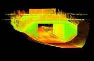
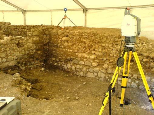
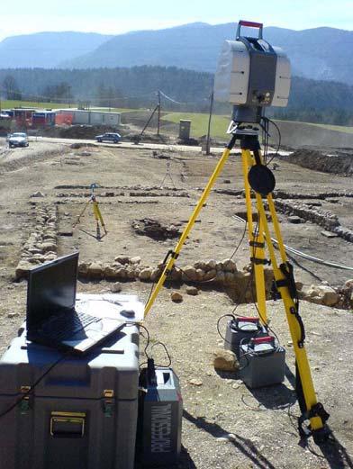
8 Geoservis Our samples and experiences Cultural heritage Archeological sites Large structures Industry Pipelines Roads, tunnels Virtual reality Reverse engineering Geoservis: samples Archeology Archeological findings in Mošnje
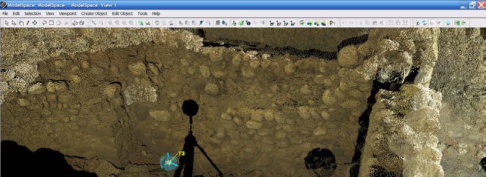
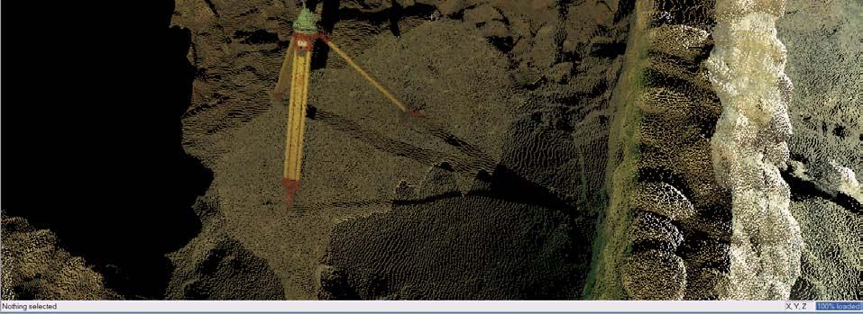
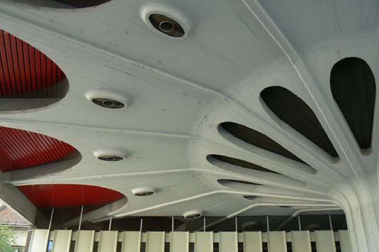
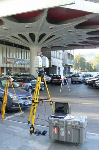
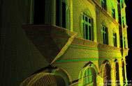
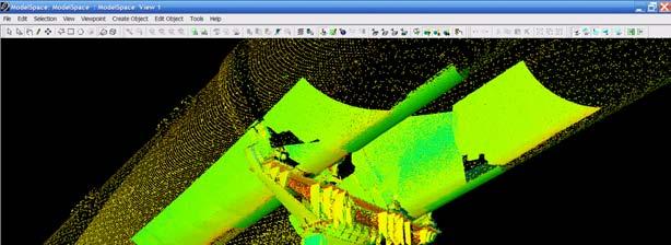
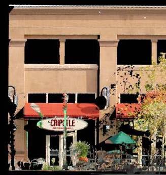
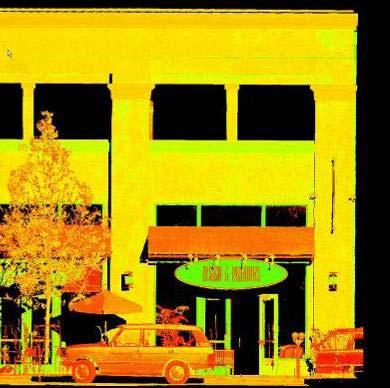
9 Geoservis: samples Archeology Geoservis: samples Architecture Former gas station


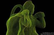
10 Geoservis: samples Architecture Registered and geo-referenced point cloud with modelled edges will allow precise as-built and reconstruction. Geoservis: samples Reverse engineering Famous tank M84 at the military barracs in Ilirska Bistrica


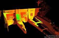
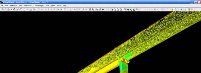
11 Geoservis: samples Reverse engineering Point cloud with every single detail on a vehicle Geoservis: samples Industry Documentary photo Mosaic photo collected by the scanner integrated digital camera
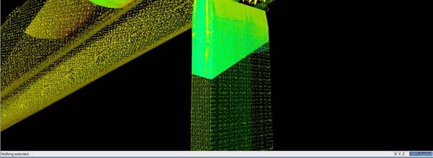
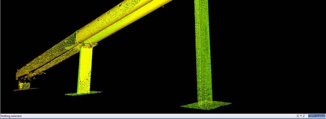
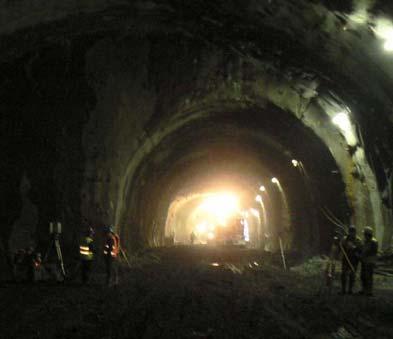
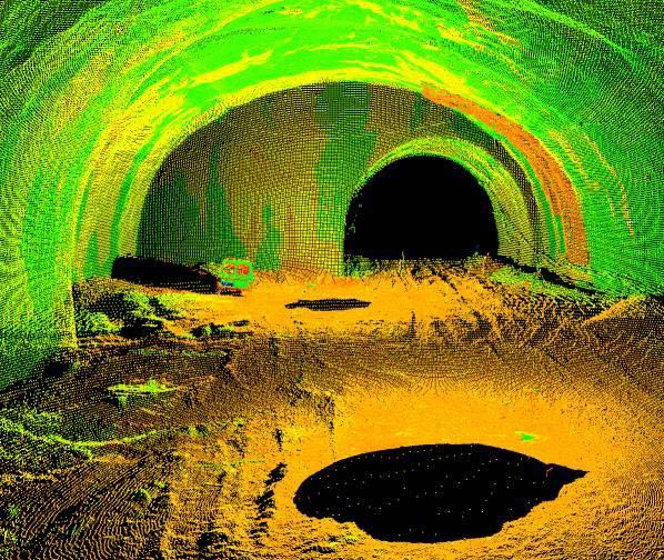
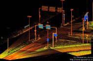
12 Geoservis: samples Industry Point cloud - coarse and additionally scanned detail Geoservis: samples Roads and tunnels


13 Thank you for your attention!
Leica ScanStation C10 The All-in-One Laser Scanner for Any Application
 The All-in-One Laser Scanner for Any Application Versatility, Productivity, Value Many organizations interested in laser scanning to diversify and/or improve current business have been waiting for a scanner
Most as-built information is still manually collected. Today s Design Market
 Agenda 1. Overview of 3D laser scanning 2. HDS 3D Laser scanning applications Leica ScanStation2 True Color Scan 3. Demonstration of HDS & Trueview 4. Questions and Answers The advanced 3D Laser Scanning
Increase Field Survey Efficiency by Merging Technologies in NOVA MultiStation. Vincent Lui Leica Geosystems Ltd
 Increase Field Survey Efficiency by Merging Technologies in NOVA MultiStation Vincent Lui Leica Geosystems Ltd Advantages of Laser Scanning Advantages of TPS Measurements Advantages of Imaging Advantages
Leica ScanStation C5 Scalable Laser Scanner
 Leica ScanStation C5 Scalable Laser Scanner Leica ScanStation C5 Scalable from the Start Companies entering into laser scanning are often faced with inflexible and complex situations and would like a scalable
Geospatial Engineering Problems & Solutions Associated With NDP Roads, Tunnelling & Civil Engineering Projects Use of HDS Leica Laser Scanners
 Geospatial Engineering Problems & Solutions Associated With NDP Roads, Tunnelling & Civil Engineering Projects Use of HDS Leica Laser Scanners Laser Scanning Laser Scanning is a method of collecting large
Laser Scanning. 3D Model is not existing and is required for: studies revamping maintenance HSE integration in another 3D model archiving
 Laser Scanning Laser Scanning Laser scanning is used whenever: 3D Model is not existing and is required for: studies revamping maintenance HSE integration in another 3D model archiving 2 Object acquisition
3D Terrestrial Laser Scanner Innovative Applications for 3D Documentation
 3D Terrestrial Laser Scanner Innovative Applications for 3D Documentation Rodney Chaffee Head of Sales, FARO Asia Pacific 3D Laser Scaning Market 2017 2.3 Billion $ 2012 1.3 Billion $ CAGR : > 12% Source:
3D Laser Scanner VS1000 User Manual
 3D Laser Scanner VS1000 User Manual 1 VS1000 Introduction SMART MAX GEOSYSTEMS CO., LTD VS1000 3D Laser Scanner based on pulses ranging principle, could quick acquire massive point cloud data from the
Italian pavilion in 3D, project for EXPO 2015, Milan (Italy) JRC 3D RECONSTRUCTOR POWERFUL. ADVANCED. PROFESSIONAL
 JRC 3D RECONSTRUCTOR POWERFUL. ADVANCED. PROFESSIONAL") Italian pavilion in 3D, project for EXPO 2015, Milan (Italy) JRC 3D RECONSTRUCTOR POWERFUL. ADVANCED. PROFESSIONAL OVERVIEW JRC 3D Reconstructor is the well known multi-platform and multi-resolution software
Italian pavilion in 3D, project for EXPO 2015, Milan (Italy) JRC 3D RECONSTRUCTOR POWERFUL. ADVANCED. PROFESSIONAL OVERVIEW JRC 3D Reconstructor is the well known multi-platform and multi-resolution software
Leica Cyclone 5.4 Technical Specifications
 Leica Cyclone 5.4 Technical Specifications HDS Scanner control and operation Scan Scan Scan Register Model Survey Viewer Acquire and display image Acquire image at specified resolution (high, medium, low)
Trimble VISION Positions from Pictures
 Trimble VISION Positions from Pictures This session will cover What Is Trimble VISION? Trimble VISION Portfolio What Do you Need? How Does It Work & How Accurate Is It? Applications Resources Trimble VISION
Leica Cyclone 8.1 Leica CloudWorx Technical Specifications
 Leica 8.1 Leica CloudWorx Technical Specifications Leica 8.1 Technical Specifications HDS SCANNER CONTROL AND OPERATION & REGISTRATION Acquire and display image ^ ^ ^ Acquire image at specified resolution
Siberian State Academy of Geodesy
 Siberian State Academy of Geodesy USING LASER SCANNING FOR ESTIMATING MINES OUTPUT VOLUMES AND 3D MODELING OF GEOLOGICAL SITUATION Vladimir A. Seredovich, Alexander V. Seredovich, Michael D. Kozoriz Russian
Leica High-Definition Surveying Systems. Leica HDS3000. The Industry Standard for High-Definition Surveying
 Leica High-Definition Surveying Systems Leica HDS3000 The Industry Standard for High-Definition Surveying HDS High-Definition Surveying TM : Laser Scanning Redefined High-Definition Surveying, or HDS,
The Leica HDS Family. The Right Tool for the Job HDS3000 HDS2500 HDS4500. Cyclone & CloudWorx. Press the QuickScan button to define the field-of-view.
 HDS2500 High accuracy scanner, ideal for fixed or raised installations when leveled tripod mounting is not practical, or areas with less stringent field-of-view requirements. The Leica HDS Family Time-of-flight
Leveraging Point Clouds to Produce Accurate As-Built Models. Sonia Delgadillo
 Leveraging Point Clouds to Produce Accurate As-Built Models Sonia Delgadillo Time What is CADWorx fieldpipe? Easy customization Comprehensive specs Short learning curve AutoCAD -based CADWorx Plant Design
technical notes trimble realworks software
 technical notes trimble realworks software A POWERFUL 3D LASER SCANNING OFFICE SOFTWARE SUITE Designed for today s multifaceted scanning professional, Trimble RealWorks is a powerful office software that
Trimble Realworks Software
 TECHNICAL NOTES Trimble Realworks Software A Powerful 3D Laser Scanning Office Software Suite DESIGNED FOR TODAY S MULTIFACETED SCANNING PROFESSIONAL, TRIMBLE REALWORKS IS A POWERFUL OFFICE SOFTWARE THAT
SURVEY 3.0. Innovative field solutions for Surveyors X PAD. works when you do
 Innovative field solutions for Surveyors works when you do X PAD INNOVATIVE FIELD SOLUTION FOR SURVEYORS The software for survey, stakeout and control, ensuring productivity and flexibility in the field,
IP-S2 HD. High Definition 3D Mobile Mapping System
 IP-S2 HD High Definition 3D Mobile Mapping System Integrated, turnkey solution Georeferenced, Time-Stamped, Point Clouds and Imagery High Density, Long Range LiDAR sensor for ultimate in visual detail
TAKING LIDAR SUBSEA. Adam Lowry, Nov 2016
 TAKING LIDAR SUBSEA Adam Lowry, Nov 2016 3D AT DEPTH Based in the technology hub of Boulder, Colorado, 3D at Depth is dedicated to the development of underwater laser measurement sensors and software Patented
BIM & Digital Transformation Scotland Live 2018 Capturing 3D Reality at the push of a button
 BIM & Digital Transformation Scotland Live 2018 Capturing 3D Reality at the push of a button Gary Kelly Country Manager Scotland Leica Geosystems @LeicaScot Capturing 3D Reality at the push of a button
POINT CLOUD based REVERSE ENGINEERING. Young-Ho Chai, Ph.D
 POINT CLOUD based REVERSE ENGINEERING Young-Ho Chai, Ph.D 3D Spatial Survey Workflow Hardware Requirements Phase Based Laser Scanner: -Leica ScanStation P20 x 1EA -Usage: Short-range, ~80m Time of Flight
INTEGRATING PHOTOGRAMMETRIC TECHNOLOGIES AND GEODETIC METHODS FOR 3D MODELING
 INTEGRATING PHOTOGRAMMETRIC TECHNOLOGIES AND GEODETIC METHODS FOR 3D MODELING Georgeta Pop Faculty of Geodesy, Geodesy and Photogrammetry Department, Technical University of Civil Engineering Bucharest,
Reality Capture using: RPAS Technologies & Image Laser Scanners
 Reality Capture using: RPAS Technologies & Image Laser Scanners by Johan Erasmus (RPAS Technologies) & Barend Bornman (Image Laser Scanners) from Aciel Geomatics Laser Scanners High-Definition Surveying
3D IN GIS. 1. Presentation of the results of the scientific and technical contents
 G. Nagy, A. Szepes 3D in GIS 3D IN GIS NAGY Gábor, assistant professor, University of West Hungary, Faculty of Geoinformatics, Department of GIS, ng@geo.info.hu SZEPES András, associate professor, University
UAVs & IMAGES ACCESSORIES ABOUT GEXCEL
 LIDAR SOFTWARE UAVs & IMAGES MONITORING MOBILE MAPPING ACCESSORIES OTHER ABOUT GEXCEL BUSINESS TEAM LOCATIONS Gexcel offices are located in Italy in two Innovation Centers SALES NETWORK Gexcel s worldwide
MODELING CITY HALL S FAÇADE USING LASER SCANNING TECHNOLOGY
 Преглед НЦД 15 (2009), 59 63 Vladimir Pajić, Dušan Jovanović Miro Govedarica (Faculty of Technical Sciences, Novi Sad, Serbia) MODELING CITY HALL S FAÇADE USING LASER SCANNING TECHNOLOGY Abstract. This
TERRESTRIAL LASER SCANNER DATA PROCESSING
 TERRESTRIAL LASER SCANNER DATA PROCESSING L. Bornaz (*), F. Rinaudo (*) (*) Politecnico di Torino - Dipartimento di Georisorse e Territorio C.so Duca degli Abruzzi, 24 10129 Torino Tel. +39.011.564.7687
Scan-Copter 2.0. Strength by Cooperation. a product of 4D-IT GmbH & von-oben e.u. High-Quality. 3D Documentation. supported by UAV
 Scan-Copter 2.0 a product of 4D-IT GmbH & von-oben e.u. Peter Dorninger Dominik Krawczyk Clemens Nothegger Strength by Cooperation 3D Documentation Multimedia Applications Data Processing Sensor Integration
Real World to Virtual World. With Geomagic Design X
 Real World to Virtual World With Geomagic Design X About OR3D OR3D based in UK with offices in Wrexham (Wales) and Bristol (England) Cover the UK and Internationally UK s largest supplier of Geomagic software
Comparing Aerial Photogrammetry and 3D Laser Scanning Methods for Creating 3D Models of Complex Objects
 Comparing Aerial Photogrammetry and 3D Laser Scanning Methods for Creating 3D Models of Complex Objects A Bentley Systems White Paper Cyril Novel Senior Software Engineer, Bentley Systems Renaud Keriven
Realworks Software. A Powerful 3D Laser Scanning Office Software Suite
 TECHNICAL NOTES Realworks Software A Powerful 3D Laser Scanning Office Software Suite Trimble RealWorks is a powerful office software that imports rich data from your 3D laser scanning instrument and transforms
Digital Preservation of the Aurelius Church and the Hirsau Museum Complex by Means of HDS and Photogrammetric Texture Mapping
 Master Thesis Ruxandra MOROSAN Ruxandra MOROSAN Digital Preservation of the Aurelius Church and the Hirsau Museum Complex by Means of HDS and Photogrammetric Texture Mapping Duration of the Thesis: 6 months
RealWorks Software. A Powerful 3D Laser Scanning Office Software Suite
 TECHNICAL NOTES RealWorks Software A Powerful 3D Laser Scanning Office Software Suite Trimble RealWorks is a powerful office software that imports rich data from your 3D laser scanning instrument and transforms
Comparing Aerial Photogrammetry and 3D Laser Scanning Methods for Creating 3D Models of Complex Objects
 www.bentley.com Comparing Aerial Photogrammetry and 3D Laser Scanning Methods for Creating 3D Models of Complex Objects A Bentley White Paper Cyril Novel Senior Software Engineer, Bentley Systems Renaud
3D Laser Scanning Technology. Fast, Safe, Accurate. Rugged hardware and powerful software combined with streamlined survey workflow
 3D Laser Scanning Technology Fast, Safe, Accurate Rugged hardware and powerful software combined with streamlined survey workflow Maptek specialises in the research, development and application of 3D laser
IP-S2 HD HD IP-S2. 3D Mobile Mapping System. 3D Mobile Mapping System
 HD HD 3D Mobile Mapping System 3D Mobile Mapping System Capture Geo-referenced, Time-Stamped Point Clouds and Imagery 3D Scanning of Roadside Features 360º Camera for Spherical Image Capture Dual Frequency
Leica Geosystems UAS Airborne Sensors. MAPPS Summer Conference July 2014 Alistair Stuart
 Leica Geosystems UAS Airborne Sensors MAPPS Summer Conference July 2014 Alistair Stuart 1 Sensors for UAS! Promise of UAS is to expand aerial data acquisition capabilities for traditional and non-traditional
USE THE 3D LASER SCANNING FOR DOCUMENTATION THE RIGA CATHEDRAL IN LATVIA
 USE THE 3D LASER SCANNING FOR DOCUMENTATION THE RIGA CATHEDRAL IN LATVIA Maris Kalinka, Elina Rutkovska, Department of Geomatic, Riga Technical University, Azenes 16-109, Riga, Latvia, geomatika@geomatika.lv
The Processing of Laser Scan Data for the Analysis of Historic Structures in Ireland
 The 7th International Symposium on Virtual Reality, Archaeology and Cultural Heritage VAST (2006) M. Ioannides, D. Arnold, F. Niccolucci, K. Mania (Editors) The Processing of Laser Scan Data for the Analysis
High resolution survey for topographic surveying
 IOP Conference Series: Earth and Environmental Science OPEN ACCESS High resolution survey for topographic surveying To cite this article: L C Luh et al 2014 IOP Conf. Ser.: Earth Environ. Sci. 18 012067
Advanced Highway Maintenance and Construction Technology Research Center
 Advanced Highway Maintenance and Construction Technology Research Center Department of Mechanical and Aerospace Engineering University of California at Davis Creating Standards and Specifications for the
Comparing Quality of Aerial Photogrammetry and 3D Laser Scanning Methods for Creating 3D Models of Objects
 Environmental Engineering 10th International Conference eissn 2029-7092 / eisbn 978-609-476-044-0 Vilnius Gediminas Technical University Lithuania, 27 28 April 2017 Article ID: enviro.2017.182 http://enviro.vgtu.lt
3D SPATIAL DATA ACQUISITION AND MODELING OF ANGHEL SALIGNY MONUMENT USING TERRESTRIAL LASER SCANNING
 JOURNAL OF APPLIED ENGINEERING SCIENCES VOL. 2(15), issue 2_2012 ISSN 2247-3769 ISSN-L 2247-3769 (Print) / e-issn:2284-7197 3D SPATIAL DATA ACQUISITION AND MODELING OF ANGHEL SALIGNY MONUMENT USING TERRESTRIAL
ROAD-SCANNER COMPACT APPLICATION FIELDS MAIN FEATURES
 ROAD-SCANNER COMPACT Mobile Mapping System by GEXCEL & SITECO collaboration A smaller mobile system for asset management and cartography suited for ZOLLER & FRÖHLICH PROFILER 9012 laser scanner. 2 + 3
BIM for infrastructure make easy with Laser Scanner. 17 October Beng Chieh Quah Head of Marketing Asia Pacific
 BIM for infrastructure make easy with Laser Scanner 17 October 2016 Beng Chieh Quah Head of Marketing Asia Pacific who is? founded in 1981 NASDAQ since 1997 Global technology company Offering a range of
Trimble MX2 mobile mapping
 Trimble MX2 mobile mapping user applications Point clouds within your reach The Trimble MX2 is a vehicle-mounted spatial imaging system which combines high resolution laser scanning and panoramic cameras
The Trimble 3D Scanning Solution: Designed by Surveyors for Surveyors
 The Trimble 3D Scanning Solution: Designed by Surveyors for Surveyors TRIMBLE 3D SCANNING Designed by surveyors for surveyors, the Trimble 3D scanning solution follows the surveying workflow you re familiar
IDENTIFICATION DEFORMATION AREAS OF SLOPS USING TERRESTRIAL LASER
 IDENTIFICATION DEFORMATION AREAS OF SLOPS USING TERRESTRIAL LASER SCANNER PRELIMINARY RESEARCH Bartłomiej Ćmielewski 1 Abstract The identification of the deformation of superficial objects, not monolithic,
XXV FIG International Congress KUALA LUMPUR Highly Detailed 3D Modelling of Mayan Cultural Heritage using an UAV
 XXV FIG International Congress KUALA LUMPUR 2014 Highly Detailed 3D Modelling of Mayan Cultural Heritage using an UAV Cornelis Stal, Britt Lonneville, Timothy Nuttens, Philippe De Maeyer, Alain De Wulf
High Definition Modeling of Calw, Badstrasse and its Google Earth Integration
 Master Thesis Yuanting LI High Definition Modeling of Calw, Badstrasse and its Google Earth Integration Duration of the Thesis: 6 months Completion: July, 2014 Supervisors: Prof.Dr.-Ing.Dieter Fritsch
3D MODELING OF CLOSE-RANGE OBJECTS: PHOTOGRAMMETRY OR LASER SCANNING?
 3D MODELING OF CLOSE-RANGE OBJECTS: PHOTOGRAMMETRY OR LASER SCANNING? F. Remondino 1 A. Guarnieri 2 A. Vettore 2 1 Institute of Geodesy and Photogrammetry ETH Hönggerberg - Zurich, Switzerland e-mail:
Towards Virtual Reality GIS
 'Photogrammetric Week 05' Dieter Fritsch, Ed. Wichmann Verlag, Heidelberg 2005. Haala 285 Towards Virtual Reality GIS NORBERT HAALA, Stuttgart ABSTRACT Due to the rapid developments in the field of computer
SPAR, ELMF 2013, Amsterdam. Laser Scanning on the UK Highways Agency Network. Hamish Grierson Blom Uk
 SPAR, ELMF 2013, Amsterdam Laser Scanning on the UK Highways Agency Network Hamish Grierson Blom Uk www.blomasa.com www.blom-uk.co.uk Blom UK Part of the Blom Group Blom Group - Europe s largest aerial
Version 5.0 English. Leica ScanStation C10/C5 User Manual
 Version 5.0 English Leica ScanStation C10/C5 User Manual ScanStation C10/C5, Introduction Introduction 2 Purchase Congratulations on the purchase of a ScanStation C10/C5 instrument. This manual contains
POLARIS Laser Scanner
 POLARIS Laser Scanner Compact, Powerful, Scanning Technology from Teledyne Optech The Optech Polaris Terrestrial Laser Scanner (TLS) delivers accurate, precise data faster than ever before, bridging the
Geospatial database for heritage building conservation
 IOP Conf. Series: Earth and Environmental Science 18 (2014) 012087 doi:10.1088/1755-1315/18/1/012087 Geospatial database for heritage building conservation W N F W A Basir1,3, H Setan1, Z M ajid1, A Chong2
Version 2.0 English. Leica ScanStation C10 User Manual
 Version 2.0 English Leica ScanStation C10 User Manual ScanStation C10, Introduction Introduction 2 Purchase Congratulations on the purchase of a ScanStation C10 instrument. This manual contains important
2/9/2016. Session Agenda: Implementing new Geospatial Technologies for more efficient data capture
 Implementing new Geospatial Technologies for more efficient data capture Jay Haskamp Applied Geospatial Engineer Steve Richter VP Sales Session Agenda: Today s changing technologies and what lies ahead
REGISTRATION, VISUALISATION, MODELLING & QUERY TOOLS
 REGISTRATION, VISUALISATION, MODELLING & QUERY TOOLS BASIC 3D navigation, Pan, Zoom, Rotate 3D mouse support Panoramic view mode Align to surface view mode Cloud Level of Detail for fast visualisation
Geosystems Monday Hands-on Sessions
 Geosystems Monday Hands-on Sessions 1110: HDS University - Leica ScanStation P30/40 (and C10 & P20) Operation and Surveying Workflows (CEU eligible nominal fees will apply) The all new Leica ScanStation
Trimble Business Center Software, v3.30
 Trimble Business Center Software, v3.30 We are pleased to announce a new version of the Trimble Business Center software, version 3.30. This new version includes over 30 new features and enhancements increasing
Third Rock from the Sun
 Geodesy 101 AHD LiDAR Best Practice The Mystery of LiDAR Best Practice Glenn Jones SSSi GIS in the Coastal Environment Batemans Bay November 9, 2010 Light Detection and Ranging (LiDAR) Basic principles
Leica Cyclone 9.1 and Leica CloudWorx Technical Specifications
 Leica 9.1 and Leica CloudWorx Technical Specifications Leica 9.1 Technical Specifications REGISTRATION, VISUALIZATION, MODELING & QUERY TOOLS 3D navigation Panoramic view mode Cloud Level of Detail for
Cyclone Tips and Tricks. Hexagon Geosystems Track June 2012
 Cyclone Tips and Tricks Hexagon Geosystems Track June 2012 Built-in Hotkeys Enhanced Working Format Open GL Modes There are some very powerful built-in viewing hotkeys in Cyclone. Here are some of them:
Leica Public Safety Solutions Versatile. Durable. Admissible
 Leica Public Safety Solutions Versatile. Durable. Admissible Public Safety Solutions 3D Laser Scanners Software Training and Consulting Services Leica ScanStation PS Series Professional Grade 3D Laser
GRAPHICS TOOLS FOR THE GENERATION OF LARGE SCALE URBAN SCENES
 GRAPHICS TOOLS FOR THE GENERATION OF LARGE SCALE URBAN SCENES Norbert Haala, Martin Kada, Susanne Becker, Jan Böhm, Yahya Alshawabkeh University of Stuttgart, Institute for Photogrammetry, Germany Forename.Lastname@ifp.uni-stuttgart.de
Overview of the Trimble TX5 Laser Scanner
 Overview of the Trimble TX5 Laser Scanner Trimble TX5 Revolutionary and versatile scanning solution Compact / Lightweight Efficient Economical Ease of Use Small and Compact Smallest and most compact 3D
Trimble 3D Laser Scanning TRANSFORMING THE WAY THE WORLD WORKS
 Trimble 3D Laser Scanning Speed, Precision and Versatility Complete Solutions for Every Challenge CAPTURE AND DELIVER PRECISE DATA. FASTER. For scanning professionals, speed and precision are critical.
2/19/2018. Who are we? Who am I? What is Scanning? How does scanning work? How does scanning work? Scanning for Today s Surveyors
 2/19/2018 Who are we? Scanning for Today s Surveyors Survey, GIS, and Construction dealer Founded in 1988 Employee Owned Headquartered in Bismarck, ND States covered: ND, SD, MN, MT, WY, CO, UT, ID, WA,
IMAGER The new way of scanning highly accurate, fast, reliable and flexible.
 IMAGER 5006 The new way of scanning highly accurate, fast, reliable and flexible www.zf-laser.com Advantages of the product IMAGER 5006 Wireless operation via PDA (Bluetooth) With the IMAGER 5006 Zoller+Froehlich
An Undergraduate Project with Terrestrial Laser Scanner for Purpose of Architectural Survey
 Theory and Application of Laser Scanning ISPRS Summer School 2007 Ljubljana,Slovenia An Undergraduate Project with Terrestrial Laser Scanner for Purpose of Architectural Survey Cemal Özgür KIVILCIM ISPRS
Geometric Accuracy Investigations of the Latest Terrestrial Laser Scanning Systems
 Thomas Kersten, Klaus Mechelke, Maren Lindstaedt, Harald Sternberg Geometric Accuracy Investigations of the Latest Terrestrial Laser Scanning Systems Outline of presentation Introduction Laser scanning
Leica DISTO X4 Designed for bright, outdoor environments
 Leica DISTO X4 Designed for bright, outdoor environments Pointfinder camera The DISTO X4 is equipped with a Pointfinder camera allowing you to easily target distant objects in bright sunlight. Even if
Building a 3D reference model for canal tunnel surveying using SONAR and LASER scanning
 ISPRS / CIPA Workshop «UNDERWATER 3D RECORDING & MODELING» 16 17 April 2015 Piano di Sorrento (Napoli), Italy Building a 3D reference model for canal tunnel surveying using SONAR and LASER scanning E.
3D Industrial plants. Documentation
 3D Industrial plants Documentation Published by: FARO Europe GmbH & Co. KG, Lingwiesenstrasse 11/2, D-70825 Korntal-Münchingen, Tel: +49 7150 9797-0, Fax: +49 7150 9797-44, info@faroeurope.com, www.faro.com
OLERDOLA S CAVE, CATALONIA, PAST AND PRESENT: A VIRTUAL REALITY RECONSTRUCTION FROM TERRESTRIAL LASER SCANNER AND GIS DATA
 LM VC OLERDOLA S CAVE, CATALONIA, PAST AND PRESENT: A RECONSTRUCTION FROM TERRESTRIAL AND GIS DATA B. Pucci a, A. Marambio a a Virtual City Modelling Lab, Politecnical University of Catalonia, 08012 Barcelona,
3D ponttechnológia használata napjainkban október. 10. Tatabány, Mérnöki továbbképzés Zeke Zsolt Mérnök üzletkötő
 3D ponttechnológia használata napjainkban 2018. október. 10. Tatabány, Mérnöki továbbképzés Zeke Zsolt Mérnök üzletkötő Leica BLK3D NEW based on photogrametry Leica HDS Termékportfólió BLK360 RTC360 P40/50
Leica Cyclone 7.0 Leica CloudWorx 4.0 and 2.0 Technical Specifications
 Leica Cyclone 7.0 Leica CloudWorx 4.0 and 2.0 Technical Specifications Leica Cyclone 7.0 Technical Specifications HDS Scanner Control and Operation Acquire and display image Acquire image at specified
A New Approach for Façade Documentation Using Laser Scanner
 Australian Journal of Basic and Applied Sciences, 5(5): 1080-1085, 2011 ISSN 1991-8178 A New Approach for Façade Documentation Using Laser Scanner 1 Ahmed K. Abdel-Gawwad and 2 Yasser M. El-Sherbiny 1,2
COMPARATIVE STUDY ON METHODS FOR 3D MODELLING OF URBAN AREAS
 COMPARATIVE STUDY ON METHODS FOR 3D MODELLING OF URBAN AREAS E. Oniga a a Department of Terrestrial Measurements and Cadastre, Technical University Gheorghe Asachi of Iasi, D. Mangeron Street, Iasi, Romania
3D Laser Scanner. Fast, Portable, Accurate. Long range laser scanner Modular design configured to suit your survey needs
 3D Laser Scanner Fast, Portable, Accurate Long range laser scanner Modular design configured to suit your survey needs Introducing the Maptek I-Site 8820 laser scanner The Maptek I-Site 8820 laser scanner
IMPROVEMENT OF AIRCRAFT MECHANICAL DAMAGE INSPECTION WITH ADVANCED 3D IMAGING TECHNOLOGIES
 IMPROVEMENT OF AIRCRAFT MECHANICAL DAMAGE INSPECTION WITH ADVANCED 3D IMAGING TECHNOLOGIES MARK MAIZONNASSE 60TH A4A NDT FORUM SEPTEMBER 2017, FORT LAUDERDALE, FL, USA BRIDGING PHYSICAL AND DIGITAL WORLDS
A New Direction in GIS Data Collection or Why Are You Still in the Field?
 GeoAutomation The Mobile Mapping System Survey-Enabled Imagery A New Direction in GIS Data Collection or Why Are You Still in the Field? Presentation to: URISA BC GIS Technology Showcase January 19, 2011
Z+F IMAGER 5006i. The new way of scanning highly accurate, fast, reliable and flexible
 Z+F IMAGER 5006i The new way of scanning highly accurate, fast, reliable and flexible Z+F IMAGER 5006i An improved system based upon the highly regarded Z+F IMAGER 5006 Stand alone concept Improved point
Watershed Sciences 4930 & 6920 ADVANCED GIS
 Watershed Sciences 4930 & 6920 ADVANCED GIS TERRESTRIAL LASER SCANNING (AKA GROUND BASED LIDAR) Joe Wheaton PURPOSE OF TODAY S DEMONSTRATION Introduce you to TLS Demystify TLS & LiDaR TODAY S PLAN I. What
A selection of our previous clients:
 Survey Solutions Geo-Spatial Survey Solutions Ltd Contact: Tel: Email: Y X Roger Davies 07713 160041 roger.davies@geo-spatial.co.uk www.geo-spatial.co.uk A selection of our previous clients: English Heritage
Ability of Terrestrial Laser Scanner Trimble TX5 in Cracks Monitoring at Different Ambient Conditions
 World Applied Sciences Journal 34 (12): 1748-1753, 2016 ISSN 1818-4952 IDOSI Publications, 2016 DOI: 10.5829/idosi.wasj.2016.1748.1753 Ability of Terrestrial Laser Scanner Trimble TX5 in Cracks Monitoring
Explore Laser Scanning in As-Built Survey. Vijay Chowdhary SE: BIM/CIM
 Explore Laser Scanning in As-Built Survey Vijay Chowdhary SE: BIM/CIM About FARO The world leader in portable 3-D measurement and imaging technology EMEA Headquarters Korntal-Münchingen, Germany APAC Headquarters
3D Reconstruction of Ancient Structures Assisted by Terrestrial Laser Scanning Technology
 2nd International Forum on Management, Education and Information Technology Application (IFMEITA 2017) 3D Reconstruction of Ancient Structures Assisted by Terrestrial Laser Scanning Technology Li Xuefei
MODELING OF THE PLAN DA MATTUN ARCHAEOLOGICAL SITE USING A COMBINATION OF DIFFERENT SENSORS
 MODELING OF THE PLAN DA MATTUN ARCHAEOLOGICAL SITE USING A COMBINATION OF DIFFERENT SENSORS D. Novák, P. Tokarczyk*, P.W. Theiler Institute of Geodesy and Photogrammetry, ETH Zürich, 8093 Zürich, Switzerland
MODERN TECHNOLOGIES IN RESEARCH AND EDUCATION AT THE INSTITUTE OF GEODESY AND GEOINFORMATICS
 MODERN TECHNOLOGIES IN RESEARCH AND EDUCATION AT THE INSTITUTE OF GEODESY AND GEOINFORMATICS Andrzej Borkowski, Wojciech Sowa, Jarosław Bosy, Bernard Kontny Institute of Geodesy and Geoinformatics DRUŽICOVÉ
Table Of Contents. Introduction Installation Included Materials System Requirements Quick Start... 9
 Cyclone 5.8 Table Of Contents Introduction... 3 Cyclone Software Introduction... 3 Installation... 5 Included Materials... 5 System Requirements... 5 Installing Cyclone... 6 Obtaining your Cyclone License...
Automatic image network design leading to optimal image-based 3D models
 Automatic image network design leading to optimal image-based 3D models Enabling laymen to capture high quality 3D models of Cultural Heritage Bashar Alsadik & Markus Gerke, ITC, University of Twente,
Leica Campus Knowledge at your Fingertips
 Leica Campus Knowledge at your Fingertips Training Schedule 2010 1 Leica Campus Training Schedule 2010 Leica Campus Training Packages offers flexible courses designed to suit your company s needs and the
Marc De Bruyne 3D Design Improvement Leader, DOW Chemical
 Marc De Bruyne 3D Design Improvement Leader, DOW Chemical John Foster Director, Profox Companies DOW Chemical Terneuzen in the Netherlands Globally, second largest DOW site after Freeport US. Producing
Case studies about using Mobile Mapping System (MMS) on traffic network mapping
 on traffic network mapping") HUNGARIAN GEODETIC AND MAPPING CORPORATION LTD. Case studies about using Mobile Mapping System (MMS) on traffic network mapping Peter Csörgits Chief Engineer Hungarian Geodetic and Mapping co. Ltd. What
HUNGARIAN GEODETIC AND MAPPING CORPORATION LTD. Case studies about using Mobile Mapping System (MMS) on traffic network mapping Peter Csörgits Chief Engineer Hungarian Geodetic and Mapping co. Ltd. What
TERRESTRIAL LASER SCANNING AND APPLICATION IN GEODETIC ENGINEERING
 TERRESTRIAL LASER SCANNING AND APPLICATION IN GEODETIC ENGINEERING Marko Pejić U n i ve rs i t y o f B e l g ra d e, Fa c u l t y o f C i v i l E n g i n e e r i n g Mostar, 10.19.2017. TLS method and
Leica Cyclone 9.1 and Leica CloudWorx Technical Specifications
 Leica 9.1 and Leica CloudWorx Technical Specifications Leica 9.1 Technical Specifications REGISTRATION, VISUALISATION, MODELLING & QUERY TOOLS 3D navigation, including 3D mouse support Panoramic view mode