Rapid generation of 3D GIS content from reality capture data sources. Keir Keightley, HDR
|
|
|
- Bathsheba Flowers
- 5 years ago
- Views:
Transcription


1 Rapid generation of 3D GIS content from reality capture data sources Keir Keightley, HDR
2 Purpose Why do we want 3D GIS content? A picture is worth a thousand words, and more, if you can navigate it in 3D Visualization: a)key to demonstrating capability when pursuing work b)powerful for communicating ideas, information and progress among project team members c)effective in revealing completed results to clients


3 Purpose Why do we want 3D GIS content? A picture is worth a thousand words, and more, if you can navigate it in 3D Reality capture: Current state of an object of interest and its environment ( as is conditions) Rapid, detailed, cost effective Broadly accessible Better than as-built drawings, traditional survey, manual measurements and photographs Users can consume 3D content via widely available GIS platforms

4 Methods Hardware, Software and Workflow


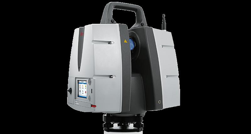

5 Capturing Reality Laser scanner or other point cloud generating device


6 Software Scan alignment: Scene, ReCap, CloudCompare (fls, e57, others) Segmentation and clean-up: CloudCompare (e57, ply) Surface meshing: Meshlab (ply, dae) Modeling: SketchUp (dae, skp)

7 Reality Capture Modeling Workflow 1. Scan site (experience goes a long way) 2. Align scans: generally completed as part of the scan process by scanning technician 3. Create unified point cloud

 using")
8 Reality Capture Modeling Workflow 4. Segment data into logical groups (e.g. interior walls by room/floor, ceilings/floors, roof, exterior walls, surrounding site) using CloudCompare (v2.8.1)


9 Hardware, Software and Workflow Reality Capture Modeling Workflow 5. Clean and decimate data: a. Remove noise and extraneous data b. Reduce data density and generate uniform sample (minimum distance sample)
, export to *.")

10 Reality Capture Modeling Workflow 6. Transform data for easier use in modeling (z axis is different in modeling program), export to *.ply Initial rotation and translation: Secondary rotation (to fix axis transposition in Sketchup):

, export to collada file")
11 Reality Capture Modeling Workflow 7. Mesh point cloud to create surfaces (ball pivoting, Meshlab v1.3 beta), export to collada file format (*.dae)


12 Reality Capture Modeling Workflow 8. Import mesh files to modeling software, create cross sections as needed (vertical, horizontal or oblique) in Sketchup (v2017)

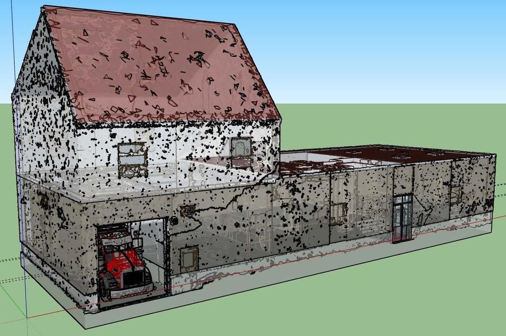
13 Reality Capture Modeling Workflow 9. Generate finished 3D model surfaces based on reality capture based surfaces

14

15 Reality Capture Modeling Workflow 10.Place model in real world location adjusting horizontal position, rotation angle and elevation

16 Site/Environment Modeling Workflow 1. Assemble geospatial data for inclusion in site modeling 2. Create empty CityEngine project 3. Import vector data, aerial and elevation data

17 Site/Environment Modeling Workflow 4. Assign procedural modeling rules to feature groups, such as... a. Extrude buildings b. Assign tree species and height c. Customize roadway rules to best approximate reality

18 Site/Environment Modeling Workflow 5. Import detailed model from reality capture workflow 6. Port to viewing platforms (online/agol, offline CEViewer, Google Earth, others)

19 Site/Environment Modeling Workflow 5. Import detailed model from reality capture workflow 6. Port to viewing platforms (online/agol, offline CEViewer, Google Earth, others)


20 Site/Environment Modeling Workflow 5. Import detailed model from reality capture workflow 6. Port to viewing platforms (online/agol, offline CEViewer, Google Earth, others)

21 Site/Environment Modeling Workflow 5. Import detailed model from reality capture workflow 6. Port to viewing platforms (online/agol, offline CEViewer, Google Earth, others)
22 Results Product, Issues, Recommendations


23 Reality Captured Detail like angled ramp is not lost to generic modeling
24 Reality Captured Error tracking possible by comparing mesh with modeled surfaces. Deviation between measured and modeled data revealed in surface difference maps.


25 Results are portable and accessible Visualization is at the team s fingertips ArcGIS Online Link
26 Questions Acknowledgments CloudCompare: danielgm.net GNU GPL MeshLab: meshlab.net, isti.cnr.it (open source)
GUIDE TO POST-PROCESSING OF THE POINT CLOUD
 GUIDE TO POST-PROCESSING OF THE POINT CLOUD Contents Contents 3 Reconstructing the point cloud with MeshLab 16 Reconstructing the point cloud with CloudCompare 2 Reconstructing the point cloud with MeshLab
TcpMDT. Digital Terrain Model Version 7.5. TcpMDT
 Digital Terrain Model Version 7.5 Versions and Modules PROFESSIONAL STANDARD IMAGES SURVEYING POINT CLOUD Product Features STANDARD Surveying Points Management Digital Terrain Model Contours Terrain Cross
Esri UC2013. Technical Workshop. Type Presentation Name Here
 Type Presentation Name Here 2013 Esri International User Conference July 8 12, 2013 San Diego, California Technical Workshop 3D Analyst An Introduction Deepinder Deol Michael Contreras Why use 3D GIS?
From 2D to 3D at Esri
 From 2D to 3D at Esri Paul Hardy, Esri Inc phardy@esri.com, Cambridge, UK SHORT PAPER This short paper provides an overview of the 3D capabilities of a modern GIS, illustrated by the Esri ArcGIS system,
Trimble RealWorks. What s new in version 9.0
 Trimble RealWorks What s new in version 9.0 Trimble RealWorks v9.0 What s new Over 40 new features and enhancements Navigation and visualization improvements SketchUp interoperability Additional 3 rd party
From 2D to 3D at Esri
 From 2D to 3D at Esri OGC/EuroSDR workshop on CityGML in National Mapping Paul Hardy phardy@esri.com Business Development Consultant National Mapping & Cadastre Esri 3D GIS Visualize Manage Share Analyze
Frequently Asked Questions
 Frequently Asked Questions FAQ Sections FAQ Sections... 1 General Questions about FARO Zone 3D... 2 Q. What makes FARO Zone 3D different from other drawing or CAD programs?... 2 Q. What is the difference
SketchUp Quick Start For Surveyors
 SketchUp Quick Start For Surveyors Reason why we are doing this SketchUp allows surveyors to draw buildings very quickly. It allows you to locate them in a plan of the area. It allows you to show the relationship
Tutorial 15: Publish web scenes
 Tutorial 15: Publish web scenes Table of Contents....................................... 3 2 In this tutorial: Part 1: Export CityEngine scene to Web Scene (.3ws) Part 2: Preview Web Scene locally Part
Introduction to Google SketchUp
 Introduction to Google SketchUp When initially opening SketchUp, it will be useful to select the Google Earth Modelling Meters option from the initial menu. If this menu doesn t appear, the same option
3DReshaper Application. Tank Control with 3DReshaper
 3DReshaper Application Tank Control with 3DReshaper Contents 1. Extract the best cylinder... 2 2. 3D Inspection... 2 Compare the tank to the best cylinder... 2 Add labels... 3 Print a report... 3 Go to
2011 Bentley Systems, Incorporated. Bentley Descartes V8i Advancing Information Modeling For Intelligent Infrastructure
 Bentley Descartes V8i Advancing Information Modeling For Intelligent Infrastructure Agenda Why would you need Bentley Descartes? What is Bentley Descartes? Advanced Point Cloud Workflows Advanced Terrain
IGTF 2016 Fort Worth, TX, April 11-15, 2016 Submission 149
 IGTF 26 Fort Worth, TX, April -5, 26 2 3 4 5 6 7 8 9 2 3 4 5 6 7 8 9 2 2 Light weighted and Portable LiDAR, VLP-6 Registration Yushin Ahn (yahn@mtu.edu), Kyung In Huh (khuh@cpp.edu), Sudhagar Nagarajan
Licensed Features - Trimble Business Center v3.10
 Licensed Features - Trimble Business Center v3.10 The following table lists the features available in Trimble Business Center based on the installed. Feature No License Base Complete Advanced Photogrammetry
TcpMDT Version 7.0 Summary of Differences with Version 6.5
 Sumatra, 9 E-29190 Málaga (Spain) www.aplitop.com Tel.: +34 95 2439771 Fax: +34 95 2431371 TcpMDT Version 7.0 Summary of Differences with Version 6.5 CAD Versions supported TcpMDT 7 works with several
Automatic generation of 3-d building models from multiple bounded polygons
 icccbe 2010 Nottingham University Press Proceedings of the International Conference on Computing in Civil and Building Engineering W Tizani (Editor) Automatic generation of 3-d building models from multiple
GIS Data Collection. This chapter reviews the main methods of GIS data capture and transfer and introduces key practical management issues.
 9 GIS Data Collection OVERVIEW This chapter reviews the main methods of GIS data capture and transfer and introduces key practical management issues. It distinguishes between primary (direct measurement)
New Features in TerraScan. Arttu Soininen Software developer Terrasolid Ltd
 New Features in TerraScan Arttu Soininen Software developer Terrasolid Ltd Default Coordinate Setup Default coordinate setup category added to Settings Defines coordinate setup to use if you open a design
PhotoMesh v7.0. What s New in PhotoMesh v7.0
 PhotoMesh v7.0 PhotoMesh v7.0 fully automates the generation of high-resolution, textured, 3D mesh models from standard 2D photographs. Combining any number of photographs, in a wide range of formats and
Version 6.1 Release Notes September 2016
 Version 6.1 Release Notes September 2016 Copyright 2016 FARO. All rights reserved. No part of this publication may be reproduced or transmitted in any form or by any means without written permission of
Geospatial database for heritage building conservation
 IOP Conf. Series: Earth and Environmental Science 18 (2014) 012087 doi:10.1088/1755-1315/18/1/012087 Geospatial database for heritage building conservation W N F W A Basir1,3, H Setan1, Z M ajid1, A Chong2
TLS Data Processing and Exploration Manual
 Katherine Shervais (UNAVCO), Marin Clark (University of Michigan) Collecting data in the field is only the first step in the complete TLS workflow. This manual will take you through the skills needed to
TCP MDT Digital Terrain Model - V7.5
 TCP MDT Digital Terrain Model - V7.5 Standard Version Introduction The Standard Version is suitable for carrying out all kinds of topographical survey projects, terrain profiles, volume calculations etc.
User s guide. November LSE S.r.l. All rights reserved
 User s guide November 2015 2015 LSE S.r.l. All rights reserved WARNING In writing this manual every care has been taken to offer the most updated, correct and clear information possible; however unwanted
Quantifier Pro User Guide
 Quantifier Pro User Guide Table of Contents Word did not find any entries for your table of contents. In your document, select the words to include in the table of contents, and then in the Formatting
Suite en It Up with Autodesk ReCap
 Chad Studer ADSK Solutions RC3165 Static and mobile laser scanning technologies capture millions of points and provide photorealistic interactive virtual sites known as point clouds. With Autodesk ReCap
MatterHackers. How to make a 3D model using Google Earth. Written By: Ryan Lutz. How to make a 3D model using Google Earth data
 MatterHackers How to make a 3D model using Google Earth data Written By: Ryan Lutz 2017 matterhackers.dozuki.com Page 1 of 20 INTRODUCTION EDIT 7/25/17: Sadly, Sketchup has changed the map service they
FILTER PACKAGE USER S GUIDE
 FILTER PACKAGE USER S GUIDE 1 CONTENT I. Introduction... 3 II. Installation... 3 III. Using the filters... 4 a- General... 4 b- Edge filter... 5 c- Uniform filter... 7 d- Angular filter... 8 e- Circle
Using Laser Scanning technology and software. Chris Palmer Sales Engineer 28 th April
 Construction Verification Using Laser Scanning technology and software Chris Palmer Sales Engineer 28 th April 2017 1 Contents What is construction verification? How do we measure and check construction
TLS Parameters, Workflows and Field Methods
 TLS Parameters, Workflows and Field Methods Marianne Okal, UNAVCO June 20 th, 2014 How a Lidar instrument works (Recap) Transmits laser signals and measures the reflected light to create 3D point clouds.
TLS Parameters, Workflows and Field Methods
 TLS Parameters, Workflows and Field Methods Marianne Okal, UNAVCO GSA, October 20 th, 2017 How a Lidar instrument works (Recap) Transmits laser signals and measures the reflected light to create 3D point
Getting Started. Extruding Features. Convert to feature class
 http://gmv.cast.uark.edu A Method Store for Advanced Survey and Modeling Technologies Mon, 01 Apr 2013 03:29:18 +0000 en-us hourly 1 http://wordpress.org/?v=3.5.1 http://gmv.cast.uark.edu/modeling/software-visualization/sketchup/workflow-sketchup/arcscene-tosketchup-to-arcscene/
TLS Parameters, Workflows and Field Methods
 TLS Parameters, Workflows and Field Methods Marianne Okal, UNAVCO GSA, September 23 rd, 2016 How a Lidar instrument works (Recap) Transmits laser signals and measures the reflected light to create 3D point
SketchUp. SketchUp. Google SketchUp. Using SketchUp. The Tool Set
 Google Google is a 3D Modelling program which specialises in making computer generated representations of real-world objects, especially architectural, mechanical and building components, such as windows,
Overview of the Trimble TX5 Laser Scanner
 Overview of the Trimble TX5 Laser Scanner Trimble TX5 Revolutionary and versatile scanning solution Compact / Lightweight Efficient Economical Ease of Use Small and Compact Smallest and most compact 3D
TOPOSCOPY, A CLOSE RANGE PHOTOGRAMMETRIC SYSTEM FOR ARCHITECTS AND LANDSCAPE DESIGNERS
 TOPOSCOPY, A CLOSE RANGE PHOTOGRAMMETRIC SYSTEM FOR ARCHITECTS AND LANDSCAPE DESIGNERS A. C. Groneman-van der Hoeven Bureau Toposcopie, Bachlaan 78, 6865 ES Doorwerth, The Netherlands. info@toposcopie.nl
Outline of Presentation. Introduction to Overwatch Geospatial Software Feature Analyst and LIDAR Analyst Software
 Outline of Presentation Automated Feature Extraction from Terrestrial and Airborne LIDAR Presented By: Stuart Blundell Overwatch Geospatial - VLS Ops Co-Author: David W. Opitz Overwatch Geospatial - VLS
Laser Surveys BIM ready models LASER SURVEYS. BIM Ready Models. A guide for our Clients. P a g e 1
 LASER SURVEYS BIM Ready Models A guide for our Clients P a g e 1 Introduction - the purpose of this guide: Survey information for the construction industry has a long-established tradition and is generally
Analytical and Computer Cartography Winter Lecture 14: Three Dimensional Mapping and Modeling
 Analytical and Computer Cartography Winter 2017 Lecture 14: Three Dimensional Mapping and Modeling 3D measurement systems: remote sensing of objects First generation DEMs, photogrammetry and contour conversion
Creating and Maintaining Your 3D Basemap. Brian Sims Dan Hedges Gert van Maren
 Creating and Maintaining Your 3D Basemap Brian Sims Dan Hedges Gert van Maren Complementary Resource Email (no marketing) A copy of the presentation Links to today s web demos Links to training materials
Rapid Energy Modeling and Sustainable Design with Reality Capture Jessica Miller TRO Jung Brannen
 Rapid Energy Modeling and Sustainable Design with Reality Capture Jessica Miller TRO Jung Brannen MP6081-P With the increasing need to promote sustainable design in existing buildings, one of the most
TerraScan New Features
 www.terrasolid.com TerraScan New Features Arttu Soininen 23.01.2018 Import Scanner Positions for Trajectories File / Import scanner positions menu command in Manage Trajectories reads scanner positions
Displayed with permission The American Surveyor April/May Copyright 2009 Cheves Media
 NASA s Environmental Simulation Chamber A at the Johnson Space Center in Houston will require upgrades to accommodate testing of components for the new space telescopes. Laser scanning with the FARO LS
Leica Cyclone 5.4 Technical Specifications
 Leica Cyclone 5.4 Technical Specifications HDS Scanner control and operation Scan Scan Scan Register Model Survey Viewer Acquire and display image Acquire image at specified resolution (high, medium, low)
Notes and Observations of the South Napa Earthquake August 24, 2014
 Notes and Observations of the August 24, 2014 Case Study: Pre- and Post-Quake 3D Laser Scanning Of the Historic Gordon Building By Shari Kamimori October 16, 2014 The Historic Gordon Building is located
3D Terrestrial Laser Scanner Innovative Applications for 3D Documentation
 3D Terrestrial Laser Scanner Innovative Applications for 3D Documentation Rodney Chaffee Head of Sales, FARO Asia Pacific 3D Laser Scaning Market 2017 2.3 Billion $ 2012 1.3 Billion $ CAGR : > 12% Source:
POINT CLOUD PROCESSING
 POINT CLOUD PROCESSING August 19-20 Northern California Bentley Bash 2011 UC Berkeley Berkeley, CA Taught by: Mike Lazear Point Cloud Processing Point Cloud Processing N O R T H E R N C A L I F O R N I
Version 6.2 Release Notes February 2017
 Version 6.2 Release Notes February 2017 Copyright 2017 FARO. All rights reserved. No part of this publication may be reproduced or transmitted in any form or by any means without written permission of
GETTING STARTED TABLE OF CONTENTS
 Sketchup Tutorial GETTING STARTED Sketchup is a 3D modeling program that can be used to create 3D objects in a 2D environment. Whether you plan to model for 3D printing or for other purposes, Sketchup
Visual 2012 Help Index
 Visual 2012 Help Index Absolute Coordinates 2.1 Cartesian Coordinates Aim 7.4.3 Place and Aim Luminaires 7.4.4 Reaiming Luminaires Align Cursor and Plane to Current View 9.6 Align to View Align Cursor
Virtualizing Boathouses in Dwejra, Malta for Access through WebGIS Applications (Abstract)
") Virtualizing Boathouses in Dwejra, Malta for Access through WebGIS Applications (Abstract) Daniel LANGENHAUN, Erich BUHMANN, Matthias PIETSCH, Santosh CHOUGULE and Philip PAAR 1 Keywords Digital Landscape
Virtualizing Boathouses in Dwejra, Malta for Access through WebGIS Applications (Abstract) Daniel LANGENHAUN, Erich BUHMANN, Matthias PIETSCH, Santosh CHOUGULE and Philip PAAR 1 Keywords Digital Landscape
With FARO PointSense for Revit. Jörg Braunes Platform Owner Software Chris Palmer Sales Engineer 1
 From Point Clouds to BIM Models With FARO PointSense for Revit Jörg Braunes Platform Owner Software Chris Palmer Sales Engineer 1 Agenda Scan to BIM with Revit PointClouds in Revit Advanced Workflow with
APPLICATIONS OF OPEN AND FREE SOFTWARE: FROM UNDERWATER TO THE SKY
 APPLICATIONS OF OPEN AND FREE SOFTWARE: FROM UNDERWATER TO THE SKY ISPRS Working Group V/2 Conference, Cultural heritage data acquisition and processing 17th 19th August 2011 - University of York, UK Why
ROAD SURFACE STRUCTURE MONITORING AND ANALYSIS USING HIGH PRECISION GPS MOBILE MEASUREMENT SYSTEMS (MMS)
") ROAD SURFACE STRUCTURE MONITORING AND ANALYSIS USING HIGH PRECISION GPS MOBILE MEASUREMENT SYSTEMS (MMS) Bonifacio R. Prieto PASCO Philippines Corporation, Pasig City, 1605, Philippines Email: bonifacio_prieto@pascoph.com
ROAD SURFACE STRUCTURE MONITORING AND ANALYSIS USING HIGH PRECISION GPS MOBILE MEASUREMENT SYSTEMS (MMS) Bonifacio R. Prieto PASCO Philippines Corporation, Pasig City, 1605, Philippines Email: bonifacio_prieto@pascoph.com
Visual Information Solutions. E3De. The interactive software environment for extracting 3D information from LiDAR data.
 Visual Information Solutions E3De. The interactive software environment for extracting 3D information from LiDAR data. Photorealistic Visualizations. 3D Feature Extraction. Versatile Geospatial Products.
Design Workflow for AM: From CAD to Part
 Design Workflow for AM: From CAD to Part Sanjay Joshi Professor of Industrial and Manufacturing Engineering Penn State University Offered by: Center for Innovative Materials Processing through Direct Digital
3D Data Modelling at Esri. Paul Hardy Business Development Consultant Esri Europe
 3D Data Modelling at Esri Paul Hardy phardy@esri.com Business Development Consultant Esri Europe Users of 3D GIS Local government Facilities management Civil engineering 3D GIS Defense / Public Safety
Data Integration in Building Virtual Models
 Data Integration in Building Virtual Models Erik Singels, Geospatial Information Sciences Program Brent Vollmar, Department of Geosciences Adewale Okunoren, Department of Geosciences Carlos L. V. Aiken,
2/9/2016. Session Agenda: Implementing new Geospatial Technologies for more efficient data capture
 Implementing new Geospatial Technologies for more efficient data capture Jay Haskamp Applied Geospatial Engineer Steve Richter VP Sales Session Agenda: Today s changing technologies and what lies ahead
4) Click on Load Point Cloud to load the.czp file from Scene. Open Intersection_Demo.czp
 Click on Load Point Cloud to load the.czp file from Scene. Open Intersection_Demo.czp") Intersection 3D Demo 1) Open the Crash Zone or Crime Zone diagram program. 2) Click on to open the CZ Point Cloud tool. 3) Click on 3D/Cloud Preferences. a) Set the Cloud File Units (Feet or Meters). b)
Intersection 3D Demo 1) Open the Crash Zone or Crime Zone diagram program. 2) Click on to open the CZ Point Cloud tool. 3) Click on 3D/Cloud Preferences. a) Set the Cloud File Units (Feet or Meters). b)
3DCity: Create 3D city features
 3DCity: Create 3D city features Workflow: 3D City Creation Version: 1.0 Date: September 12, 2012 Map templates and workflows are ArcGIS resources that can be used to help create 2D / 3D maps and web map
Trimble Business Center Software, v3.30
 Trimble Business Center Software, v3.30 We are pleased to announce a new version of the Trimble Business Center software, version 3.30. This new version includes over 30 new features and enhancements increasing
INTEGRATING PHOTOGRAMMETRIC TECHNOLOGIES AND GEODETIC METHODS FOR 3D MODELING
 INTEGRATING PHOTOGRAMMETRIC TECHNOLOGIES AND GEODETIC METHODS FOR 3D MODELING Georgeta Pop Faculty of Geodesy, Geodesy and Photogrammetry Department, Technical University of Civil Engineering Bucharest,
Cyclone Tips and Tricks. Hexagon Geosystems Track June 2012
 Cyclone Tips and Tricks Hexagon Geosystems Track June 2012 Built-in Hotkeys Enhanced Working Format Open GL Modes There are some very powerful built-in viewing hotkeys in Cyclone. Here are some of them:
What s New in ecognition 9.0. Christian Weise
 What s New in ecognition 9.0 Christian Weise Presenting ecognition 9 Release Date: March 2014 Who s eligible? All user with a valid ecognition maintenance contract Presenting ecognition 9 ecognition version
Comparing Aerial Photogrammetry and 3D Laser Scanning Methods for Creating 3D Models of Complex Objects
 Comparing Aerial Photogrammetry and 3D Laser Scanning Methods for Creating 3D Models of Complex Objects A Bentley Systems White Paper Cyril Novel Senior Software Engineer, Bentley Systems Renaud Keriven
Creating a 3D GIS Program in the City of Cambridge
 Creating a 3D GIS Program in the City of Cambridge JEFF AMERO CITY OF CAMBRIDGE ESRI User Conference, San Diego, CA July 13, 2017 Presentation Overview -Bringing 3D GIS to Cambridge -Components of the
Comparing Aerial Photogrammetry and 3D Laser Scanning Methods for Creating 3D Models of Complex Objects
 www.bentley.com Comparing Aerial Photogrammetry and 3D Laser Scanning Methods for Creating 3D Models of Complex Objects A Bentley White Paper Cyril Novel Senior Software Engineer, Bentley Systems Renaud
LiForest Software White paper. TRGS, 3070 M St., Merced, 93610, Phone , LiForest
 0 LiForest LiForest is a platform to manipulate large LiDAR point clouds and extract useful information specifically for forest applications. It integrates a variety of advanced LiDAR processing algorithms
ARCHICAD 21 and START Edition Feature Comparison Chart 21 SE 2018 SE Complex, Multi-story Elements + + +
 ARCHICAD ARCHICAD 21 and START Edition Feature Comparison Chart 21 SE 2018 SE 2017 Modeling Complex, Multi-story Elements + + + Floor-plan Display Options for Construction Elements + + + Multi-Plane Roof
What is SketchUp? 10/3/2016. Why do you need SketchUp? A powerful way of presenting information in 3d. An easier way to draw than CAD
 Introducing What is SketchUp? A powerful way of presenting information in 3d. An easier way to draw than CAD A better way to draw than paper A great way of getting information to ALL participants in a
3D Analyst Visualization with ArcGlobe. Brady Hoak, ESRI DC
 3D Analyst Visualization with ArcGlobe Brady Hoak, ESRI DC 3D GIS Viewing geospatial data in 3D leads to new insights 2D 3D Sometimes you need to edit your data in 3D 2D 3D Some problems can only be solved
Advanced Tips for Better Translation Autodesk Revit 2010 IES
 Advanced Tips for Better Translation Autodesk Revit 2010 IES IES Worldwide Support Series A. Chan and M. Farrell What is a gbxml? When you click on Set Model Properties, even though you are doing it within
Mapping Environments Project 4 Modern Maps
 880106 Mapping Environments Project 4 Modern Maps Week 08-09: When Engineering Design Labs & University Campus: Where Group of 4: Who 15%: Worth 1 Aim: The overarching aim of this project is to introduce
Title: Improving Your InRoads DTM. Mats Dahlberg Consultant Civil
 Title: Improving Your InRoads DTM Mats Dahlberg Consultant Civil Improving Your InRoads Digital Terrain Model (DTM) Digital Terrain Model A digital representation of a surface topography or terrain composed
3D Scanners help Grovely Wood speed up their production time
 Coventry St Michaels Cathedral, built in the late 14th century. It was one of the most beautiful and largest parish churches of its time, in England until it was destroyed during the Second World War.
MODULE 1 BASIC LIDAR TECHNIQUES
 MODULE SCENARIO One of the first tasks a geographic information systems (GIS) department using lidar data should perform is to check the quality of the data delivered by the data provider. The department
OLERDOLA S CAVE, CATALONIA, PAST AND PRESENT: A VIRTUAL REALITY RECONSTRUCTION FROM TERRESTRIAL LASER SCANNER AND GIS DATA
 LM VC OLERDOLA S CAVE, CATALONIA, PAST AND PRESENT: A RECONSTRUCTION FROM TERRESTRIAL AND GIS DATA B. Pucci a, A. Marambio a a Virtual City Modelling Lab, Politecnical University of Catalonia, 08012 Barcelona,
Digital Preservation of the Aurelius Church and the Hirsau Museum Complex by Means of HDS and Photogrammetric Texture Mapping
 Master Thesis Ruxandra MOROSAN Ruxandra MOROSAN Digital Preservation of the Aurelius Church and the Hirsau Museum Complex by Means of HDS and Photogrammetric Texture Mapping Duration of the Thesis: 6 months
Team 2: Boeing KML Urban Scene Builder Technical Specification / Schedule KML Urban Scene Builder 2008
 Team 2: Boeing KML Urban Scene Builder 2008 Technical Specification / Schedule KML Urban Scene Builder 2008 CSE 498, Collaborative Design Jeff Winship Tom Pytleski Daniel Briggs Michael Jeffery Department
SketchUp Starting Up The first thing you must do is select a template.
 SketchUp Starting Up The first thing you must do is select a template. While there are many different ones to choose from the only real difference in them is that some have a coloured floor and a horizon
3DReshaper Help DReshaper Beginner's Guide. Surveying
 3DReshaper Beginner's Guide Surveying 1 of 29 Cross sections Exercise: Tunnel analysis Surface analysis Exercise: Complete analysis of a concrete floor Surveying extraction Exercise: Automatic extraction
Technical Masterclass: Making the Most of Point Cloud ReCap 360 Pro
 Developed by Cadline Limited Page 1 of 8 Technical Masterclass: Making the Most of Point Cloud ReCap 360 Pro Presented by: Geoff Woodhead, Infrastructure Specialist Page 2 of 8 Making the Most of Point
Point Cloud Classification
 Point Cloud Classification Introduction VRMesh provides a powerful point cloud classification and feature extraction solution. It automatically classifies vegetation, building roofs, and ground points.
Critical Essentials. Overview. Objectives. Recommended Prior Skills. Upon completion of these topics, you should be able to:
 Critical Essentials Visualizing spaces in three dimensions is critical to the success of the design of architectural spaces. The interplay of light, color, and space are critical concepts to master. Traditional
Creating a Competitive Edge with FARO Scanners
 CASE STUDY Creating a Competitive Edge with FARO Scanners Wesley Grimes President of Collision Engineering Associates, Inc Crash Reconstruction Firm Adopts FARO Laser Scanners To Safely Capture Scenes
Module 7 Defining Coordinate Systems
 Module 7 Defining Coordinate Systems Introduction Objectives Outline of Topics Covered The use of coordinate systems is very important in managing 3D spatial data including point clouds. In this module
On Grid: Tools and Techniques to Place Reality Data in a Geographic Coordinate System
 RC21940 On Grid: Tools and Techniques to Place Reality Data in a Geographic Coordinate System Seth Koterba Principal Engineer ReCap Autodesk Ramesh Sridharan Principal Research Engineer Infraworks Autodesk
Low-Cost Orthophoto Production Using OrthoMapper Software
 Low-Cost Orthophoto Production Using OrthoMapper Software Rick Day Penn State Cooperative Extension, Geospatial Technology Program, RGIS-Chesapeake Air Photos Historical air photos are available from a
Aerial and Mobile LiDAR Data Fusion
 Creating Value Delivering Solutions Aerial and Mobile LiDAR Data Fusion Dr. Srini Dharmapuri, CP, PMP What You Will Learn About LiDAR Fusion Mobile and Aerial LiDAR Technology Components & Parameters Project
Drone2Map for ArcGIS: Bring Drone Imagery into ArcGIS
 Drone2Map for ArcGIS: Bring Drone Imagery into ArcGIS Mike Sweeney 1 Drone2Map for ArcGIS Turn Drones into Enterprise Productivity Tools ArcGIS Drone2Map for ArcGIS Create 2D and 3D products from raw drone
TCP MDT Digital Terrain Model - V7
 TCP MDT Digital Terrain Model - V7 Professional Version Introduction The Professional Version is designed to assist the user at all stages of developing a project in the context of Topography and Civil
3D recording of archaeological excavation
 5 th International Conference Remote Sensing in Archaeology The Age of Sensing 13-15 October 2014 - Duke University 3D recording of archaeological excavation Stefano Campana UNIVERSITY of CAMBRIDGE Faculty
UTILIZACIÓN DE DATOS LIDAR Y SU INTEGRACIÓN CON SISTEMAS DE INFORMACIÓN GEOGRÁFICA
 UTILIZACIÓN DE DATOS LIDAR Y SU INTEGRACIÓN CON SISTEMAS DE INFORMACIÓN GEOGRÁFICA Aurelio Castro Cesar Piovanetti Geographic Mapping Technologies Corp. (GMT) Consultores en GIS info@gmtgis.com Geographic
Network licenses (5 seat minimum - price per seat and excl. VAT): Network extension (existing license required - price per seat and excl.
: Network extension (existing license required - price per seat and excl.") Pricing SketchUp Pro If you want to buy SketchUp Pro there are several options to choose from: Commercial Licenses A Standalone license costs per license only (excl. VAT): 655,- This price includes 1 year
Pricing SketchUp Pro If you want to buy SketchUp Pro there are several options to choose from: Commercial Licenses A Standalone license costs per license only (excl. VAT): 655,- This price includes 1 year
Realworks Software. A Powerful 3D Laser Scanning Office Software Suite
 TECHNICAL NOTES Realworks Software A Powerful 3D Laser Scanning Office Software Suite Trimble RealWorks is a powerful office software that imports rich data from your 3D laser scanning instrument and transforms
AutoCAD 2014 Preview Guide
 AutoCAD 2014 Preview Guide Design and shape the world around you with the powerful, connected design tools found in Autodesk AutoCAD software, one of the world s leading 2D and 3D design applications.
Texturing Techniques in 3D City Modeling
 Texturing Techniques in 3D City Modeling 1 İdris Kahraman, 2 İsmail Rakıp Karaş, Faculty of Engineering, Department of Computer Engineering, Karabuk University, Turkey 1 idriskahraman@karabuk.edu.tr, 2
NEW PERSPECTIVE SEPTEMBER 2017
 VOLUME 7 ISSUE 6 SEPTEMBER 2017 NEW PERSPECTIVE 18 26 38 POLARIS SHOWS THE WAY The terrestrial laser scanning market continues to evolve, providing today s practitioner with an abundance of options LITTLE
Three-Dimensional Laser Scanner. Field Evaluation Specifications
 Stanford University June 27, 2004 Stanford Linear Accelerator Center P.O. Box 20450 Stanford, California 94309, USA Three-Dimensional Laser Scanner Field Evaluation Specifications Metrology Department