Aerial Mapping using UAS. Jeff Campbell
|
|
|
- Imogen Long
- 5 years ago
- Views:
Transcription


1 Aerial Mapping using UAS Jeff Campbell 1
2 Agenda 1. Introduction 2. UAS Mapping Explained 3. Use Cases / Outputs 4. Technologies 5. Training Methods 6. Implementation Strategies 7. Emerging Technologies 2
3 Vertical Aspect Specializing in Unmanned Aerial Vehicle (UAS) Mapping Services Consultation Training (Face-to face and Remote) Offer related hardware / software Robota Eclipse Fixed Wing Texas Dealer Pix4D Pro Mapping / Virtual Surveyor Software V-Map Ground Control Targets FAA Certification, Insured 3
4 Our Background Jeff Campbell Navy Rotary Wing Pilot Lockheed Martin Program Manager Involved in UAS since 2012 Mark Paulson Registered Professional Surveyor Private Pilot Sales / training of UAS since
5 UAS Mapping Explained 5

6 Plan & Load the mission Simplified Workflow Fly Capture images Process, Provide Output 6
7 UAS vs. Conventional Mapping Higher Speed of Capture Smaller Crew size More Data Points Less Cost Higher Efficiency Safer Less Impact on Operations Comparable accuracy (w/ground Control) 7
8 Use Cases / Outputs 8
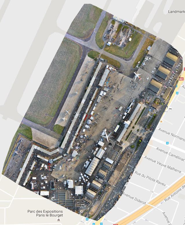
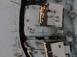
9 Orthomosaic 9

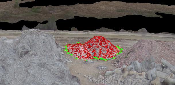
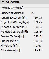
10 Stockpile Volume Calculations 10
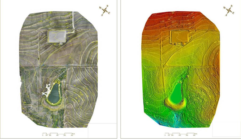
11 Topographic 11 11

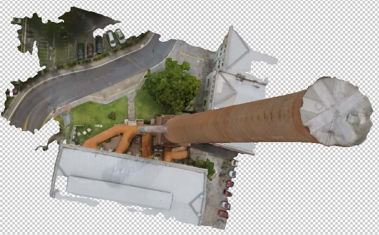
12 3D Model 12
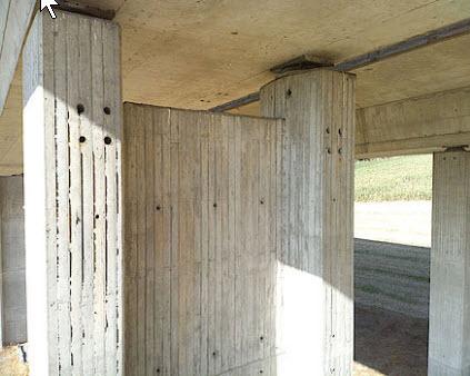

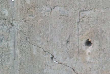
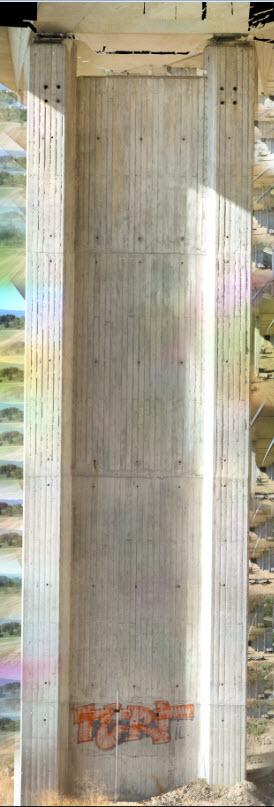
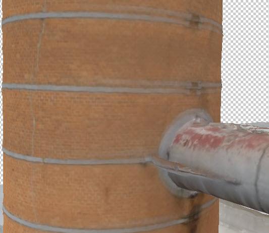
13 Inspections 13
14 Inspections 14
15 UAS Mapping: Technologies 15
16 UAS Mapping Requirements UAS System (fixed wing or multirotor) Image capture app Tablet or laptop for field use Pix4D Processing software Desktop or hi end laptop for processing Training (UAS, image capture, post-processing) FAA Part 107 certification for commercial ops 16


17 Typical Mapping Platforms DJI Inspire 1 Robota Eclipse DJI Phantom 4 SenseFly ebee 17
18 Multitorotor vs. Fixed Wing 18
19 Multirotor vs. Fixed Wing Attribute Multirotor Fixed Wing Size of Project Up to 100 ac (~30 ac /flt) 1200 ac + (~400 ac / flt) Learning Curve Easiest + smaller datasets More complex (+ larger datasets) Landing/takeoff area Vertical (Very small) Larger clear area for takeoff/landing Altitude / detail Lower alt / higher detail / less coverage Flt times ~21 mins ~50 mins Higher alt / less detail / greater coverage Cost of entry $ $3000 $12,500 - $34,000 19

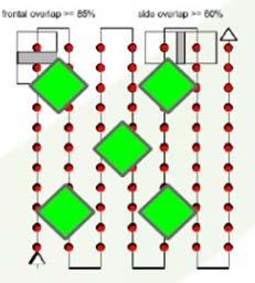
20 Flight Planning / Image Capture 20
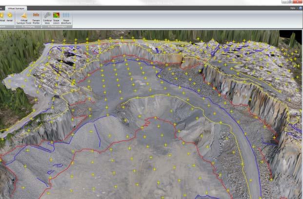
21 Post-Processing Software Pix4D Virtual Surveyor 21


22 Ensuring Accuracy Ground Control Points Professional Grade GPS Ground Control Kit 22
23 Training Methods 23
24 How We Learned Self-Taught Prior knowledge as springboard Scour tutorials, forums, groups Trial & Error Research, Guess, Purchase Aircraft, software, accessories Buy, Fly, Crash, Fix Repeat. 24
25 How We Teach Determine client s goals / experience / budget Customized, individualized training Face-to-Face Best for initial systems, flight and software training Able to teach basics in one day Ground school, flight, image capture, post-processing Follow-up with remote training Using remote PC / MAC screen access (recorded session) Assist in processing client s first projects Teach advanced processing / different output types / other software Follow-up with clients as technology improves 25
26 Implementation Strategies 26
27 Questions to ask In-House or Outsource Familiar with technology/ convinced of benefits? How much UAS mapping work anticipated? Staff available to train? Ability to invest? Desire to keep up with technology Already in related business (natural progression of capabilities?) Outsource at first prior to making decision 27
28 UAS Mapping Strategy Initial Consult with expert Start small Consumer or Prosumer Quadrotor / register with FAA Train one to two individuals Learn systems / image capture / post processing Obtain FAA Part 107 Drone certification Obtain Liability Insurance Annual around $800-$1,000 for $1M On Demand (e.g. Verifly) - from $10/hr for $1M Capture sample missions Topographic, orthographic, volume measurement, 3D modeling, etc. Work with Ground Control points (team up with surveyor at first) Learn end-to-end workflow Simple single battery missions migrate to multi-battery missions Produce deliverables for projects <100 acres 28
29 UAS Mapping Strategy - Mature Add fixed wing platform Larger areas / datasets Learn additional software tools Global Mapper / Virtual Surveyor Dedicated processing computer More complex deliverables (additional workflow) Add additional staff separate image capture from back end processing 29
30 Emerging Technologies Increasing Accuracy Proliferation of Real Time Kinematics (RTK) Accurate measurements without GCP Obstacle Avoidance Transponders / Collision Avoidance Automation: Standoff / vertical patterns / 3D modeling Airborne LIDAR Software Improvements Post Processing Flight control / Image capture Terrain Awareness Increased battery capacity / flight times Camera improvements zoom, thermal, multispectral 30
31 Jeff Campbell Mark Paulson or us at 31
Unmanned Aerial Systems: A Look Into UAS at ODOT
 Ohio Department of Transportation John R. Kasich, Governor Jerry Wray, Director Unmanned Aerial Systems: Tim Burkholder, PS Mapping Manager Division of Engineering Office of CADD and Mapping Services Kyle
Equipment. Remote Systems & Sensors. Altitude Imaging uses professional drones and sensors operated by highly skilled remote pilots
 Remote Systems & Sensors Altitude Imaging uses professional drones and sensors operated by highly skilled remote pilots Equipment www.altitude-imaging.com About Us Altitude Imaging has been providing a
DRONE MAPPING FOR CONSTRUCTION
 DRONE MAPPING FOR CONSTRUCTION POWERFUL SOLUTIONS FOR AS-BUILT SURVEYS AND SITE DOCUMENTATION - AUTOMATED FLEXIBLE PROCESSING - REPEATABLE RELIABLE ACCURACY - APPLICABLE RESULTS WE CAPTURE IMAGES FROM
Drone2Map for ArcGIS: Bring Drone Imagery into ArcGIS. Will
 Drone2Map for ArcGIS: Bring Drone Imagery into ArcGIS Will Meyers @MeyersMaps A New Window on the World Personal Mapping for Micro-Geographies Accurate High Quality Simple Low-Cost Drone2Map for ArcGIS
USING UNMANNED AERIAL VEHICLE (DRONE/FLYCAM) TECHNOLOGY IN SURVEY WORK OF PORTCOAST
 TECHNOLOGY IN SURVEY WORK OF PORTCOAST") USING UNMANNED AERIAL VEHICLE (DRONE/FLYCAM) TECHNOLOGY IN SURVEY WORK OF PORTCOAST 1. Capturing aerial images by using Drone Taking images by drones is currently applied in many fields especially in topographic
USING UNMANNED AERIAL VEHICLE (DRONE/FLYCAM) TECHNOLOGY IN SURVEY WORK OF PORTCOAST 1. Capturing aerial images by using Drone Taking images by drones is currently applied in many fields especially in topographic
TAKING FLIGHT JULY/AUGUST 2015 COMMERCIAL UAS ADVANCEMENT BALLOONS THE POOR MAN S UAV? SINGLE PHOTON SENSOR REVIEW VOLUME 5 ISSUE 5
 VOLUME 5 ISSUE 5 JULY/AUGUST 2015 TAKING FLIGHT 14 COMMERCIAL UAS ADVANCEMENT 24 BALLOONS THE POOR MAN S UAV? 30 SINGLE PHOTON SENSOR REVIEW Closing in on 500 authorizations the FAA has expedited the exemption
The Use and Applications of Unmanned- Aerial Systems (UAS) In Agriculture
 In Agriculture") The Use and Applications of Unmanned- Aerial Systems (UAS) In Agriculture R O B E R T A U S T I N, D E P A R T M E N T O F S O I L S C I E N C E N C S T A T E U N I V E R S I T Y DJI Inspire Photo Credit:
The Use and Applications of Unmanned- Aerial Systems (UAS) In Agriculture R O B E R T A U S T I N, D E P A R T M E N T O F S O I L S C I E N C E N C S T A T E U N I V E R S I T Y DJI Inspire Photo Credit:
UAS to GIS Utilizing a low-cost Unmanned Aerial System (UAS) for Coastal Erosion Monitoring
 for Coastal Erosion Monitoring") UAS to GIS Utilizing a low-cost Unmanned Aerial System (UAS) for Coastal Erosion Monitoring A New Window on the World Personal Mapping for Micro-Geographies Accurate High Quality Simple Low-Cost Drone2Map
UAS to GIS Utilizing a low-cost Unmanned Aerial System (UAS) for Coastal Erosion Monitoring A New Window on the World Personal Mapping for Micro-Geographies Accurate High Quality Simple Low-Cost Drone2Map
UAV s in Surveying: Integration/processes/deliverables A-Z. 3Dsurvey.si
 UAV s in Surveying: Integration/processes/deliverables A-Z Info@eGPS.net TODAY S PROGRAM Introduction to photogrammetry and 3Dsurvey Theoretical facts about the technology and basics of 3dsurvey Introduction
Quality Accuracy Professionalism
 GeoWing - who are we? Mapping Data Service Provider Lidar Multispectral Topographic and Planimetric Maps Elevation Models Point Clouds / 3D Models Orthophotography FAA-Authorized UAS Operators WOSB / DBE
2/9/2016. Session Agenda: Implementing new Geospatial Technologies for more efficient data capture
 Implementing new Geospatial Technologies for more efficient data capture Jay Haskamp Applied Geospatial Engineer Steve Richter VP Sales Session Agenda: Today s changing technologies and what lies ahead
FAA NEEDS PAYLOADS ROV SUAS. /robotics DARLEY OFFERS ROBOTICS EQUIPMENT, TRAINING & SUPPORT
 ROBOTICS FAA NEEDS PAYLOADS ROV SUAS SUPPORT TRAINING UAV Shop /robotics DARLEY OFFERS ROBOTICS EQUIPMENT, TRAINING & SUPPORT Darley is here to help with your departments drone program from the ground
UAS Campus Survey Project
 ARTICLE STUDENTS CAPTURING SPATIAL INFORMATION NEEDS UAS Campus Survey Project Texas A&M University- Corpus Christi, home to the largest geomatics undergraduate programme in Texas, USA, is currently undergoing
a Geo-Odyssey of UAS LiDAR Mapping Henno Morkel UAS Segment Specialist DroneCon 17 May 2018
 a Geo-Odyssey of UAS LiDAR Mapping Henno Morkel UAS Segment Specialist DroneCon 17 May 2018 Abbreviations UAS Unmanned Aerial Systems LiDAR Light Detection and Ranging UAV Unmanned Aerial Vehicle RTK Real-time
Reality Modeling Drone Capture Guide
 Reality Modeling Drone Capture Guide Discover the best practices for photo acquisition-leveraging drones to create 3D reality models with ContextCapture, Bentley s reality modeling software. Learn the
Accuracy Assessment of an ebee UAS Survey
 Accuracy Assessment of an ebee UAS Survey McCain McMurray, Remote Sensing Specialist mmcmurray@newfields.com July 2014 Accuracy Assessment of an ebee UAS Survey McCain McMurray Abstract The ebee unmanned
FAA NEEDS PAYLOADS ROV SUAS. /robotics DARLEY OFFERS ROBOTICS EQUIPMENT, TRAINING & SUPPORT
 ROBOTICS FAA NEEDS PAYLOADS ROV SUAS SUPPORT TRAINING UAV Shop /robotics DARLEY OFFERS ROBOTICS EQUIPMENT, TRAINING & SUPPORT Darley is here to help with your departments drone program from the ground
Trends in Digital Aerial Acquisition Systems
 Trends in Digital Aerial Acquisition Systems Ernest Yap Regional Sales Manager, Airborne-Americas eyap@applanix.com 1 Medium Format Digital Cameras Medium Format Digital Cameras Where does the Medium
Practical Considerations of UAS Operations on Data Quality
 Practical Considerations of UAS Operations on Data Quality Precision. Accuracy. Reliability OVERVIEW Project Planning and Execution Ground Control Data Processing and Delivery 1 OVERVIEW Get Legal: Section
Sasanka Madawalagama Geoinformatics Center Asian Institute of Technology Thailand
 Sasanka Madawalagama Geoinformatics Center Asian Institute of Technology Thailand This learning material was not prepared by ADB. The views expressed in this document are the views of the author/s and
UAV Geophysics Workshop
 UAV Geophysics Workshop September 29, 2017 www.denbury.com NYSE: DNR 1 Mapping Oilfield Infrastructure with UAV Application of high resolution photogrammetry to seismic survey planning and reclamation
Commercial suas The Right Tool for the Right Job
 Commercial suas The Right Tool for the Right Job Presentation Objectives Overview of current data collection technologies UAS Systems Overview Surveyor 2.0 Project Case Study Mobile LiDAR & suas How Do
Case Study for Long- Range Beyond Visual Line of Sight Project. March 15, 2018 RMEL Transmission and Planning Conference
 Case Study for Long- Range Beyond Visual Line of Sight Project March 15, 2018 RMEL Transmission and Planning Conference 2014 HDR Architecture, 2016 2014 HDR, Inc., all all rights reserved. Helicopters
Our Experiences with UAVs in Coastal Monitoring at Gator Lake. Capt. Joe Morrow MRD Associates, Inc. Destin, Florida
 Our Experiences with UAVs in Coastal Monitoring at Gator Lake Capt. Joe Morrow MRD Associates, Inc. Destin, Florida FSBPA 2018 National Conference on Beach Preservation Technology February 9, 2018 OVERVIEW
The Use of UAS in modern field work
 The Use of UAS in modern field work SplitRS 2015, Thessaloniki, GREECE 22/05/2015 1 ebee by sensefly Swiss-made UAV Fully autonomous flight Suitable for: Mapping, GIS, Surveying Precision Agriculture Environmental
Surveying like never before
 CAD functionalities GCP Mapping and Aerial Image Processing Software for Land Surveying Specialists Surveying like never before www.3dsurvey.si Modri Planet d.o.o., Distributors: info@3dsurvey.si +386
INTRODUCTION TO Accelerating Data Collection with Unmanned Aircraft Systems
 INTRODUCTION TO Accelerating Data Collection with Unmanned Aircraft Systems Kyle Kukuk Terry Pallotto MWCC Enviromental Conference July 10-12, 2016 Who is Here? Kyle Kukuk, PE Project Manager Blackstone
HOVERFLY LIVESKY HOVERFLY DEVELOPS BEST-IN-CLASS AERIAL ROBOTS FOR INDUSTRIAL, COMMERCIAL, GOVERNMENT, AND OTHER SPECIALIZED APPLICATIONS
 HOVERFLY LIVESKY HOVERFLY DEVELOPS BEST-IN-CLASS AERIAL ROBOTS FOR INDUSTRIAL, COMMERCIAL, GOVERNMENT, AND OTHER SPECIALIZED APPLICATIONS The LiveSky is a persistent drone vehicle with powerover-tether-technology
A COMPARISON OF STANDARD FIXED-WING VS MULTIROTOR DRONE PHOTOGRAMMETRY SURVEYS
 A COMPARISON OF STANDARD FIXED-WING VS MULTIROTOR DRONE PHOTOGRAMMETRY SURVEYS Dr Steve Harwin, UAV Operations, Tas KEY QUESTIONS What detail, scale and accuracy are needed? For change analysis the data
Assessing the Accuracy of Stockpile Volumes Obtained Through Aerial Surveying
 CASE STUDY Assessing the Accuracy of Stockpile Volumes Obtained Through Aerial Surveying Martin Remote Sensing share surveying insight DroneDeploy Introduction This report comes to us from Kelsey Martin,
The intelligent mapping & inspection drone
 The intelligent mapping & inspection drone 3 reasons to choose exom 1 flight, 3 types of imagery With exom you can switch between capturing video, still and thermal imagery during the same flight, without
Over the years, they have been used several tools to perform aerial surveys of analyzed to archaeological sites and monuments. From the plane to the
 Over the years, they have been used several tools to perform aerial surveys of analyzed to archaeological sites and monuments. From the plane to the balloon, the balloon to the telescopic rods, all of
UAS for Surveyors. An emerging technology for the Geospatial Industry. Ian Murgatroyd : Technical Sales Rep. Trimble
 UAS for Surveyors An emerging technology for the Geospatial Industry Ian Murgatroyd : Technical Sales Rep. Trimble Project Overview Voyager Quarry, located near Perth Australia Typical of hard rock mines,
Applications of Mobile LiDAR and UAV Sourced Photogrammetry
 Applications of Mobile LiDAR and UAV Sourced Photogrammetry Thomas J. Pingel and Earle W. Isibue Northern Illinois University 2017 Illinois GIS Association (ILGISA) Annual Meeting October 2-4, 2017 tpingel.org
A New Protocol of CSI For The Royal Canadian Mounted Police
 A New Protocol of CSI For The Royal Canadian Mounted Police I. Introduction The Royal Canadian Mounted Police started using Unmanned Aerial Vehicles to help them with their work on collision and crime
ALL-IN-ONE DRONE SOLUTION FOR 3D MODELING
 ALL-IN-ONE DRONE SOLUTION FOR 3D MODELING Powered by PHOTO & VIDEO FULL HD 1080P - 14MPX 3-AXIS STABILIZATION AUGMENTED POWER 30MIN FLIGHT TIME 32GB INTERNAL MEMORY INCLUDES 3D MODELING SOFTWARE SAFE VIEW
LEAK DETECTION UTILIZING SMALL UNMANNED AERIAL SYSTEMS (SUAS) PRESENTED BY MATT HALKER
 PRESENTED BY MATT HALKER") LEAK DETECTION UTILIZING SMALL UNMANNED AERIAL SYSTEMS (SUAS) PRESENTED BY MATT HALKER of Agenda Introduction Who we are Why we need leak detection Traditional methods of inspection Benefits of suas inspection
LEAK DETECTION UTILIZING SMALL UNMANNED AERIAL SYSTEMS (SUAS) PRESENTED BY MATT HALKER of Agenda Introduction Who we are Why we need leak detection Traditional methods of inspection Benefits of suas inspection
GPS-Aided Inertial Navigation Systems (INS) for Remote Sensing
 for Remote Sensing") GPS-Aided Inertial Navigation Systems (INS) for Remote Sensing www.inertiallabs.com 1 EVOLUTION OF REMOTE SENSING The latest progress in Remote sensing emerged more than 150 years ago, as balloonists took
GPS-Aided Inertial Navigation Systems (INS) for Remote Sensing www.inertiallabs.com 1 EVOLUTION OF REMOTE SENSING The latest progress in Remote sensing emerged more than 150 years ago, as balloonists took
Drone2Map: an Introduction. October 2017
 Drone2Map: an Introduction October 2017 Drone2Map: An Introduction Topics: - Introduction to Drone Mapping - Coordinate Systems - Overview of Drone2Map - Basic Drone2Map Workflow - 2D Data Processing -
Trimble UAS Portfolio Update. August 25 th 2015
 Trimble UAS Portfolio Update August 25 th 2015 Trimble UAS Portfolio Updates Trimble UX5 Setting the Standard in Mapping Trimble UX5 HP High Precision Surveying and Mapping Solution Trimble ZX5 Flexible
Generating highly accurate 3D data using a sensefly exom drone
 Generating highly accurate 3D data using a sensefly exom drone C. Álvarez 1, A. Roze 2, A. Halter 3, L. Garcia 4 1 Geomatic Engineer, Lehmann Géomètre SA 2 Application Engineer, sensefly SA 3 Geomatic
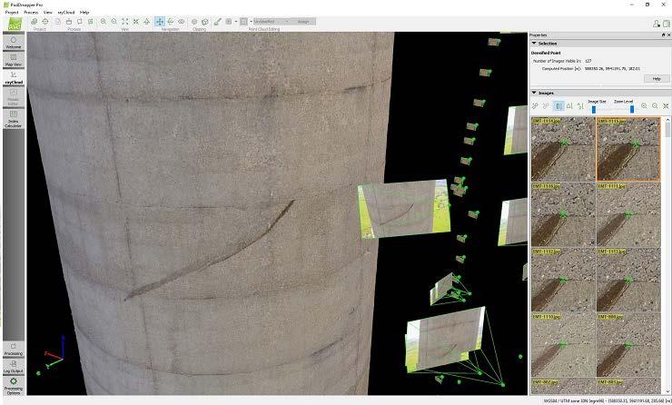
Simply powerful. Pix4Dmapper features the raycloud. Read more on Next generation aerial image processing software
 Next generation aerial image processing software Simply powerful Pix4D is your solution to convert thousands of aerial images taken by lightweight UAV or aircraft into georeferenced 2D mosaics and 3D surface
Welcome to IMAGIN. June 18, 2018
 Welcome to IMAGIN June 18, 2018 Battle Royale: Pix4D vs Drone2Map A Comparison of Drone Processing Softwares as applied to GIS and a Fly-Through of UAV/GIS workflows 2 Presentation Flight Plan 1. Introductions
Assessing 3D Point Cloud Fidelity of UAS SfM Software Solutions Over Varying Terrain
 Assessing 3D Point Cloud Fidelity of UAS SfM Software Solutions Over Varying Terrain Michael Schwind, Michael J. Starek (Presenter) 18th Annual JALBTCX Airborne Coastal Mapping and Charting Technical Workshop,
STARTING WITH DRONES. Data Collection and Remote Sensing with UAVs, etc. Dr. Bill Hazelton LS
 STARTING WITH DRONES Data Collection and Remote Sensing with UAVs, etc. Dr. Bill Hazelton LS What this Talk is About UAV-based data acquisition: What you need to get involved Processes in getting spatial
Added support for version matching between DJI Assistant 2 and flight control system.
 Date : 2017.01.18 DJI GO App Version : ios V 3.1.2, Android V 3.1.1 DJI Assistant 2 Version : 1.0.9-2 Flight Controller Firmware Version : 1.7.0.0 Added support for version matching between DJI Assistant
PHOTOGRAMMETRIC MISSION PLANNER FOR RPAS
 PHOTOGRAMMETRIC MISSION PLANNER FOR RPAS F. Gandor, M. Rehak, J. Skaloud École Polytechnique Fédérale de Lausanne (EPFL), Switzerland (florian.gandor, martin.rehak, jan.skaloud)@epfl.ch KEY WORDS: mission
Virtual and remote inspection methods
 Virtual and remote inspection methods Rasmus Lindeneg Johansen, RLJ@cowi.dk 1 How do we inspect "today"? 2 Inspection "today" Manual inspections From the ground From lift/platform By rope Data was collected
Innovative Applications of Drone Technology in the Engineering of Large Dams
 Innovative Applications of Drone Technology in the Engineering of Large Dams Giorgio Pietrangeli Giuseppe Pittalis Vincenzo Millesi Riccardo Cifra Studio Ing. G. Pietrangeli Srl Via Cicerone 28 00193 Rome
Harnessing GIS and Imagery for Power Transmission Inspection. ESRI European Users Conference October 15, 2015
 Harnessing GIS and Imagery for Power Transmission Inspection ESRI European Users Conference October 15, 2015 About Us Airborne/Threod Designer, manufacturer & service provider for multi-rotor & fixed wing
Overview of the Trimble TX5 Laser Scanner
 Overview of the Trimble TX5 Laser Scanner Trimble TX5 Revolutionary and versatile scanning solution Compact / Lightweight Efficient Economical Ease of Use Small and Compact Smallest and most compact 3D
REMOTE SENSING LiDAR & PHOTOGRAMMETRY 19 May 2017
 REMOTE SENSING LiDAR & PHOTOGRAMMETRY 19 May 2017 SERVICES Visual Inspections Digital Terrain Models Aerial Imagery Volume Computations Thermal Inspections Photo maps Aerial Video Training & Consultancy
FOUR-BAND THERMAL MOSAICKING: A NEW METHOD TO PROCESS THERMAL IMAGERY FROM UAV FLIGHT YICHEN YANG YALE SCHOOL OF FORESTRY AND ENVIRONMENTAL STUDIES
 FOUR-BAND THERMAL MOSAICKING: A NEW METHOD TO PROCESS THERMAL IMAGERY FROM UAV FLIGHT YICHEN YANG YALE SCHOOL OF FORESTRY AND ENVIRONMENTAL STUDIES OUTLINE Background Objectives Methodology Results Calibration
Best Practices for Managing Aerial and UAS Frame Imagery. Cody Benkelman, Jie Zhang
 Best Practices for Managing Aerial and UAS Frame Imagery Cody Benkelman, Jie Zhang Objectives Manage and share collections of imagery from aerial frame cameras - Professional digital cameras - Metric lens,
Zenmuse XT Release Notes
 2017.06.28 1. Firmware Version: v1.30.0.10 2. DJI Pilot App Android Version: v0.3.1 Added support for the Matrice 200. 1. This firmware upgrade is for the Zenmuse XT gimbal and camera only. It cannot be
Four Mainstream Reality Capture Tools* Optical GNSS (or more commonly GPS) Lidar. Photogrammetry 12/20/2015. Static Mobile Aerial
 Lidar. Photogrammetry 12/20/2015. Static Mobile Aerial") Four Mainstream Reality Capture Tools* Optical GNSS (or more commonly GPS) Lidar Static Mobile Aerial Photogrammetry UAV Collected Ground Collected 1 Optical Consists of three measurement devices H Angle,
Four Mainstream Reality Capture Tools* Optical GNSS (or more commonly GPS) Lidar Static Mobile Aerial Photogrammetry UAV Collected Ground Collected 1 Optical Consists of three measurement devices H Angle,
Hardware 3D Mapping Systems
 Hardware 3D Mapping Systems About Us GreenValley International GreenValley International provides 3D mapping solutions that include mobile & aerial LiDAR acquisition hardware, post-processing software
sensefly Inspection 360 More insights, less risk
 sensefly Inspection 360 More insights, less risk sensefly and Pix4D offer a turnkey solution from take-off to the final 3D model which I would recommend. It avoids wasting time, plus you benefit from customer
Integrated Multi-Source LiDAR and Imagery
 Figure 1: AirDaC aerial scanning system Integrated Multi-Source LiDAR and Imagery The derived benefits of LiDAR scanning in the fields of engineering, surveying, and planning are well documented. It has
LiDAR Surveying and the UAS Phenomenon: Understanding How to See the Wood for the Trees
 LiDAR Surveying and the UAS Phenomenon: Understanding How to See the Wood for the Trees Craig Emrick, PSM Vice-President of Mapping Services Prepared For: 51 st Transmission and Substation Design and Operation
FPVMODEL. Rescue-2. Integrated with 1 OX Zoom HD Camera Intended for Search and Rescue Missions USER MANUAL
 FPVMODEL Rescue-2 USER MANUAL Integrated with 1 OX Zoom HD Camera Intended for Search and Rescue Missions FP IU n-= WWW.FPVMODEL.COM Copyright 201 7 FPVMODEL LIMITED WARNING AND DISCLAIMER Make sure not
DJI MATRICE 600 PRO Release Notes
 Date : 2017.10.24 Aircraft Firmware : V 1.0.1.65 DJI GO App : ios V 3.1.18, Android V 3.1.11 DJI Assistant 2 : V 1.1.6 Aircraft Firmware: Increased flight safety. Fixed issue of output error when F channel
Drones for research - Observing the world in 3D from a LiDAR-UAV
 Drones for research - Observing the world in 3D from a LiDAR-UAV Program lunch seminar: Lammert Kooistra: The Unmanned Aerial Remote Sensing Facility goes 3D: Unmanned Aerial Laser Scanning Sander Mücher:
DJI AGRAS MG-1S Release Notes
 Date: 2018.03.29 Aircraft Firmware: V 2.5.0.0 Remote Controller Firmware: V 2.5.0.0 DJI MG App: V 1.5.7 DJI Assistant 2 for MG: V 2.0.0 Added support for the MG Spreading System. This firmware is only
Updates An Introduction to the New ASPSuite
 L. Graham 02 September 2017 We are releasing a significant update to the AirGon Sensor Package Software Suite (ASPSuite or just ASP) with the release of our new direct geopositioning system (DGPS), Loki.
2. POINT CLOUD DATA PROCESSING
 Point Cloud Generation from suas-mounted iphone Imagery: Performance Analysis A. D. Ladai, J. Miller Towill, Inc., 2300 Clayton Road, Suite 1200, Concord, CA 94520-2176, USA - (andras.ladai, jeffrey.miller)@towill.com
Rates Card
 Rates Card 2018 www.altitudephotography.co.uk hello@altitudephotography.co.uk 01256 630 409 2018 Altitude Aerial Photography Ltd. Limited Company Registered in England No. 09604229. Fully qualified & CAA
Open Pit Mines. Terrestrial LiDAR and UAV Aerial Triangulation for. Figure 1: ILRIS at work
 Terrestrial LiDAR and UAV Aerial Triangulation for Open Pit Mines Figure 1: ILRIS at work Figure 2: Geo-Copter X-8000 taking off ay what you will about the past few years, it has produced some useful tools
Aerial and Mobile LiDAR Data Fusion
 Creating Value Delivering Solutions Aerial and Mobile LiDAR Data Fusion Dr. Srini Dharmapuri, CP, PMP What You Will Learn About LiDAR Fusion Mobile and Aerial LiDAR Technology Components & Parameters Project
Ingesting, Managing, and Using UAV (Drone) Imagery in the ArcGIS Platform
 Imagery in the ArcGIS Platform") Ingesting, Managing, and Using UAV (Drone) Imagery in the ArcGIS Platform Cody A. Benkelman Technical Product Manager Imagery Esri cbenkelman@esri.com Version 2 17 November 2015 This in an Esri draft document
Ingesting, Managing, and Using UAV (Drone) Imagery in the ArcGIS Platform Cody A. Benkelman Technical Product Manager Imagery Esri cbenkelman@esri.com Version 2 17 November 2015 This in an Esri draft document
The ArcGIS Platform for Managing, Processing, and Sharing UAV Data
 The ArcGIS Platform for Managing, Processing, and Sharing UAV Data Cody Benkelman, Technical Product Manager - Imagery David Gadsden, Nonprofit Program Manager Esri Advancing GIS Strong and Growing..Serving
2015 TELLY TREND REPORT TELLY AWARD WINNERS TAKE ON INDUSTRY TRENDS AND TECHNOLOGIES
 2015 TELLY TREND REPORT TELLY AWARD WINNERS TAE ON INDUSTRY TRENDS AND TECHNOLOGIES 2015 TELLY TREND REPORT TREND SUMMARY Video has quickly become a major player in the way in which we communicate. It
Two-Year Academic Course Schedule - Fall 2017 through Summer Program Director: Eric Himler Campus Phone :
 AVT 101 Private Pilot Ground School 4.00 GR M GR M GR M GR M AVT 102 Private Pilot Flight 4.00 O ARR O ARR O ARR O ARR AVT 103 Intro to ATC 3.00 GR M GR M GR M GR M AVT 105 Aviation Meteorology 4.00 GR
3D Laser Scanning Technology. Fast, Safe, Accurate. Rugged hardware and powerful software combined with streamlined survey workflow
 3D Laser Scanning Technology Fast, Safe, Accurate Rugged hardware and powerful software combined with streamlined survey workflow Maptek specialises in the research, development and application of 3D laser
Photogrammetric Performance of an Ultra Light Weight Swinglet UAV
 Photogrammetric Performance of an Ultra Light Weight Swinglet UAV J. Vallet, F. Panissod, C. Strecha, M. Tracol UAV-g 2011 - Unmanned Aerial Vehicle in Geomatics September 14-16, 2011ETH Zurich Summary
Trimble GeoSpatial Products
 Expanding Solutions for Photogrammetric and Remote Sensing Professionals 55 th Photogrammetric Week in Stuttgart September 7 th 2015 Tobias Heuchel, Trimble Stuttgart, Germany Trimble GeoSpatial Products
UAVs & IMAGES ACCESSORIES ABOUT GEXCEL
 LIDAR SOFTWARE UAVs & IMAGES MONITORING MOBILE MAPPING ACCESSORIES OTHER ABOUT GEXCEL BUSINESS TEAM LOCATIONS Gexcel offices are located in Italy in two Innovation Centers SALES NETWORK Gexcel s worldwide
Hydra Fusion Tools. Capabilities Guide. Real-time 3D Reconstructions
 Hydra Fusion Tools Capabilities Guide Real-time 3D Reconstructions Hydra Fusion Tools Building a Mapping System Flying an unmanned aircraft system (UAS) is no longer a stand-alone activity. Operators are
Zenmuse XT Release Notes
 2018.03.30 1. Firmware Version: v1.31.0.00 2. DJI Pilot App Android Version: v0.5.1 3. DJI GO App ios Version: V3.1.30 4. DJI GO App Android Version: V3.1.28 1. Fixed an issue where users can't take photos
ESRI Mobile GIS Solutions Overview. Justin Fan
 ESRI Mobile GIS Solutions Overview Justin Fan Agenda Mobile GIS challenges ESRI Mobile GIS solutions ArcPad ArcGIS Mobile ArcGIS Engine Selecting a mobile GIS solution Q & A Objective To help you select
PhotoScan. Fully automated professional photogrammetric kit
 PhotoScan Fully automated professional photogrammetric kit Agisoft PhotoScan is a stand-alone photogrammetric software solution for automatic generation of dense point clouds, textured polygonal models,
Todd King, PLS, LEED AP Business Developer
 Todd King, PLS, LEED AP Business Developer TKing@McKimCreed.com 38 YEARS 378 EMPLOYEES ENR Top 500 Design Firm ENR Top 200 Environmental ENR Southeast Engineer Firms POB Geospatial Top 100 Top 50 Trenchless
COLLABORATION is KEY
 AN AERIAL ADVANTAGE COLLABORATION is KEY LIVING AND WORKING IN A WORLD OF FAST TECHNOLOGICAL ADVANCEMENT, COLLABORATION OF SKILLS IS BECOMING MORE COMMONPLACE. DTM Technologies Ltd and Seahawk AP have
DJI MATRICE 600 Release Notes
 Date : 2018.04.17 Aircraft Firmware : V 1.0.1.66 DJI GO App : ios V 3.1.31, Android V 3.1.30 DJI Assistant 2 : V 1.1.7 Aircraft Firmware: Improved altitude measuring precision by lowering barometer drift
Comparing workflow and point cloud outputs of the Trimble SX10 TLS and sensefly ebee Plus drone
 Comparing workflow and point cloud outputs of the Trimble SX10 TLS and sensefly ebee Plus drone Armin WEBER and Thomas LERCH Lerch Weber AG, Switzerland Key words: terrestrial laser scanner, Trimble SX10,
3D Modelling for surveying projects using Unmanned Arial Vehicles (UAVs) and Laser Scanning
 and Laser Scanning") University of Southern Queensland Faculty of Health, Engineering and Sciences 3D Modelling for surveying projects using Unmanned Arial Vehicles (UAVs) and Laser Scanning A dissertation submitted by Bradley
University of Southern Queensland Faculty of Health, Engineering and Sciences 3D Modelling for surveying projects using Unmanned Arial Vehicles (UAVs) and Laser Scanning A dissertation submitted by Bradley
LiDAR Drone. Land Profile to Your Desktop. Processing. for LiDAR data processing, point cloud vectorization, classification and more
 LiDAR Drone Processing Outsource to us for LiDAR data processing, point cloud vectorization, classification and more Goodland Surveys Pvt Ltd # # # Mobile/Airbone LiDAR Processing & Conversion Geo Spatial
Merging Geospatial Technologies to Improve the Bottom Line. John Whitehead Trimble Navigation Limited
 Merging Geospatial Technologies to Improve the Bottom Line John Whitehead Trimble Navigation Limited Trimble: Data Collection to Decision Making Today s Survey Professional Today s Customer Requirements
Welcome Back Photogrammetry!
 Marvin Andelin verifying proper overlap with stereoscope. What s Old is New Again Welcome Back Photogrammetry! The year was 1981. The Dodgers had taken the World Series from the Yankees in Game Six at
Northwest UAV A GLOBAL COMPANY
 FULLY AUTONOMOUS CONTROL FOR UNMANNED VEHICLES Northwest UAV A GLOBAL COMPANY Where Precision and Reliability Soar! Fully Autonomous Control Hybrid, Multirotor, Fixed-wing, Heli, Missile, Ground Vehicle,
Drones in ArcGIS Workshop. Jeff Liedtke, Alex Muleh, Doug Ridenour, Jim Michel Esri Jeff Safran, BLM
 Drones in ArcGIS Workshop Jeff Liedtke, Alex Muleh, Doug Ridenour, Jim Michel Esri Jeff Safran, BLM Drones in ArcGIS Workshop Agenda Introduction and Background Key Concepts DEMO: The Video Player Operation
The YellowScan Surveyor: 5cm Accuracy Demonstrated
 The YellowScan Surveyor: 5cm Accuracy Demonstrated Pierre Chaponnière1 and Tristan Allouis2 1 Application Engineer, YellowScan 2 CTO, YellowScan Introduction YellowScan Surveyor, the very latest lightweight
SPARK. Quick Start Guide V1.6
 SPARK Quick Start Guide V1.6 SPARK The DJI SPARK is DJI's smallest flying camera featuring a stabilized camera, Intelligent Flight Modes, and Obstacle Avoidance inside a light, portable body. Equipped
COMBINING UAV AND FAST DATA ANALYSIS TO IDENTIFY VEGETATION THREATS TO POWER LINES
 COMBINING UAV AND FAST DATA ANALYSIS TO IDENTIFY VEGETATION THREATS TO POWER LINES 1 UAV TO BUSINESS DECISIONS 100 People 100 Countries $25M raised 2 BVLOS SINCE 2012 BVLOS flights in 30+ countries MINI
BIM & Digital Transformation Scotland Live 2018 Capturing 3D Reality at the push of a button
 BIM & Digital Transformation Scotland Live 2018 Capturing 3D Reality at the push of a button Gary Kelly Country Manager Scotland Leica Geosystems @LeicaScot Capturing 3D Reality at the push of a button
James Van Rens CEO Riegl USA, Inc. Mining Industry and UAV s combined with LIDAR Commercial UAV Las Vegas October 2015 James Van Rens CEO Riegl USA
 James Van Rens CEO Riegl USA, Inc. Mining Industry and UAV s combined with LIDAR Commercial UAV Las Vegas October 2015 James Van Rens CEO Riegl USA COST EFFECIENCY CONTINUUM LIDAR and IMU Partnership Technology
Drone2Map for ArcGIS: Bring Drone Imagery into ArcGIS
 Drone2Map for ArcGIS: Bring Drone Imagery into ArcGIS Mike Sweeney 1 Drone2Map for ArcGIS Turn Drones into Enterprise Productivity Tools ArcGIS Drone2Map for ArcGIS Create 2D and 3D products from raw drone
PHANTOM 4 Release Notes
 2017.09.12 Overview Remote Controller Firmware: v1.9.3.0 DJI GO 4 App ios: v4.1.10 DJI GO 4 App Android: v4.1.10 What s New Added support for Head Tracking function when connected with the DJI Goggles.
UAS based laser scanning for forest inventory and precision farming
 UAS based laser scanning for forest inventory and precision farming M. Pfennigbauer, U. Riegl, P. Rieger, P. Amon RIEGL Laser Measurement Systems GmbH, 3580 Horn, Austria Email: mpfennigbauer@riegl.com,
SYSTEM DYNAMICS / ZACHMAN FRAMEWORK CHARACTERIZATION UAV T&E
 SYSTEM DYNAMICS / ZACHMAN FRAMEWORK CHARACTERIZATION OF UAV T&E Bharath Dantu IMSE: Industrial, Manufacturing and Systems Engineering Eric Smith RIMES: Research Institute for Manufacturing and Engineering