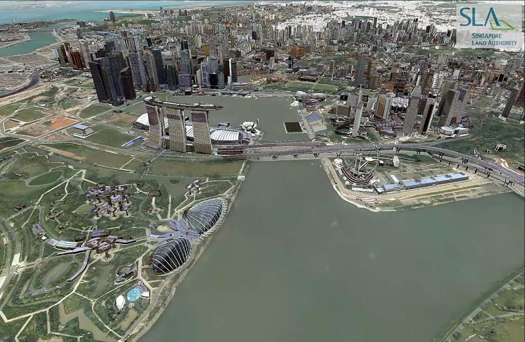
Bringing Singapore to life in 3D
|
|
|
- Augustus Nichols
- 5 years ago
- Views:
Transcription

1 Bringing Singapore to life in 3D Dr Victor Khoo, Deputy Director Singapore Land Authority

2 Bringing Singapore to life in 3D ESRI Singapore UC 2016 Dr. Victor Khoo Singapore Land Authority SLA 2016 RESTRICTED


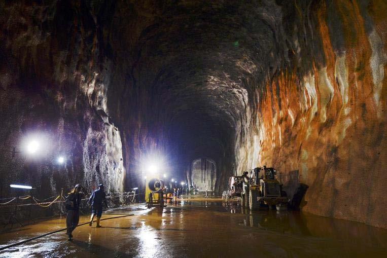
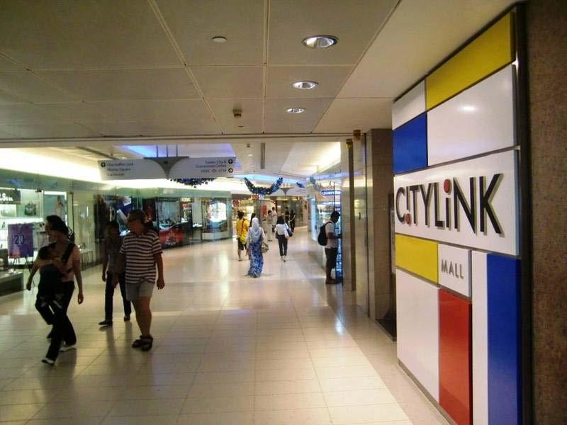
3 Creating Space Above and Below Industry Space Above Roads Underground Mall Jurong Rock Caverns (Source: JTC) Source: ST Singapore


4 Current 2D Maps Are Not Adequate Not able to fully represent the real world Low resolution and few details


5 Growing Needs for 3D Information Development Planning Underground Infrastructure Urban Heat Island 3D Geological Map DTM for Flood Management Solar Potential Study Underground Utilities Urban Air Flow Dynamic Telecommunication Coverage

6 Smart Nation Singapore is building the World's first Smart Nation by harnessing technology and gathering insights from data to the fullest with the aim of improving the lives of citizens, creating more opportunities, and building stronger communities. Measurement + Prediction = Performance


7 We Need 3D Map Data As-built 3-dimension Smart Data Model High Resolution Reliable Up-to-date 3D Map Data Applications National Security Urban Challenges Underground Development Climate Change Adaptation Development Planning

")


8 3D Mapping Framework Decision Making (Applications) Updating Workflow Satellite Remote Sensing GNSS Laser Scanning Imaging Geodetic Survey Capture Model Data Models Data Standards Modelling Techniques Managing Workflow Spatial Data Infrastructure Sharing Standards Web Technology Share Manage Single Point of Truth Database GIS


 Facility /")
 Building Building")


9 Theatre / World Country Installation / Region State / Province County 3D Mapping City Site Natural Asset Real Property Asset Air / Space Underground Water / Sea Land / Parcel 3D Cadastre Geospatial Information Small Scale (low detail) Facility / Built Large Scale (high detail) Building Building information System Space Overlay Structure System Space Overlay Linear Structure Sub-Systems Level Sub-Systems Level Node Components Room Components Room Source: NBIMS Segment Building Information Model


")


10 3D National Mapping Project Partners Phase 1 (Completed) Airborne Laser Scanning and Imaging (FY13 to FY15) Phase 2 (In-progress) Mobile Laser Scanning and Imaging (Expected Completion: Jun 17) FY13 FY14 FY15 FY16 Phase 1 Phase 2


11 Airborne Laser Scanning Optech Pegasus ALTM
")


12 Airborne Laser Scanning (Point Clouds Data) Laser Scanning Data Point Cloud Altitude of 3600ft Minimum 5 points/sq m Vertical accuracy +/- 15cm


13 Digital Surface Model (DSM) / Digital Terrain Model (DTM)


14 Leica RCD 30 Oblique Camera


15 Vertical and Oblique Images

16 Photo Map from Airborne Images Photo Map (Orthophoto)


17 Building Modelling using Imagery

18 3D Building Modelling SLA 2016


")


19 Mobile Mapping System Components IMU Inertial Measurement Unit (inside) 360 Spherical Camera - Ladybug 5 GNSS Receiver Mobile Laser Scanner Riegl VMX-450 DMI Distance Measuring Instrument 19

20 MMS Data Capturing

21 Mobile Laser Scanning Point Cloud

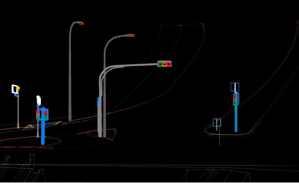
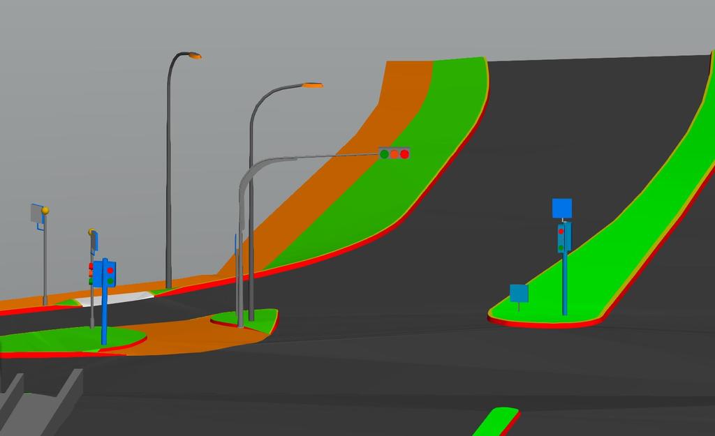
22 3D Modelling Transportation and Street Furniture


23 3D Map - Data and Products 3D Data Airborne Laser Scanning Data Airborne Vertical / Oblique Images 360 Camera Imagery Mobile Laser Scanning Data 3D Products 3D Building Models Digital Terrain Model & Digital Surface Model Photo Map 3D Road Models
24 Data Management Strategies Collect once, use by many 1. Single point of truth (SPOT) is managed and maintained in Open Source Data Format and Data Schema Embrace Open Geospatial Consortium (OGC) standard (e.g. CityGML) Ensure government data is technology-independent 2. Data standard Establish 3D data standard to ensure interoperability and support inter-agency data sharing Actively contribute and influence international 3D standard 3. Multiple source / technology


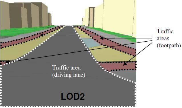
25 CityGML CityGML is an XML base data format CityGML captures 3D geometry, 3D topology, semantics, and appearance in 5 discrete scales (Levels of Detail, LoD) LoD0 Terrain Model Source: Thomas Kolbe LoD1 Block models with no roof structures LoD2 Explicit roof structures LoD3 Detailed architectural models LoD4 Interior modelled


26 Static Laser Scanner Rapidly capture very high resolution 3D data on ground level Capable of going indoor Capable of integrating color from images

27 3D Point Cloud State Property
28 Benefits to Agencies Flood Risk Map Underground Master Plan National Geological Map Slope Risk Analysis Map 3D Cadastre Coastal Protection Map Development Planning Virtual Singapore Urban Heat Island Study SolarNova Project Tree Mapping Flight Safety Planning Driverless Vehicle Development


29 Spin-off 3D indoor mapping to support Location Based Services (LBS) Underground mapping in 3D Augmented Reality and Virtual Reality Research Future city / smart city Clean energy Transport and mobility Simulation


30 Are we future-ready? Wow! It s 3D..
31

32 SLA 2015

33
Development of Geospatial Smart Cities and Management
 Presented at the FIG Congress 2018, May 6-11, 2018 in Istanbul, Turkey Development of Geospatial Smart Cities and Management (E. Yılmaz, F. Kartal, E. Uçar, K. Eren) FIG2018 - Istanbul, 8 th May 2018 1
AIRBORNE GEIGER MODE LIDAR - LATEST ADVANCEMENTS IN REMOTE SENSING APPLICATIONS RANDY RHOADS
 Place image here (10 x 3.5 ) AIRBORNE GEIGER MODE LIDAR - LATEST ADVANCEMENTS IN REMOTE SENSING APPLICATIONS RANDY RHOADS Geospatial Industry Manager HARRIS.COM #HARRISCORP Harris Company Information SECURITY
A Strategy and Vision for Enterprise 3D GIS. B r o o k s P a t r i c k A c c o u n t E x e c u t i v e b p a t r i c e s r i.
 A Strategy and Vision for Enterprise 3D GIS B r o o k s P a t r i c k A c c o u n t E x e c u t i v e b p a t r i c k @ e s r i. c o m Understanding where things are, and why, is essential for rational
Trimble Geospatial Division Integrated Solutions for Geomatics professions. Volker Zirn Regional Sales Representative
 Trimble Geospatial Division Integrated Solutions for Geomatics professions Volker Zirn Regional Sales Representative 1 Agenda Trimble GeoSpatial Division Airborne System Solutions Trimble Inpho Software
Hamilton County Enhances GIS Base Mapping with 1-foot Contours
 Hamilton County Enhances GIS Base Mapping with 1-foot Contours Presented by Larry Stout, Hamilton County GIS Manager Brad Fugate, Woolpert Inc. Today s Presentation Hamilton County s 2004 Base Mapping
Mobile LiDAR for Ground Applications. Spar 2006, March Paul Mrstik, Terrapoint Canada Inc. Craig Glennie, Terrapoint USA LLC
 Mobile LiDAR for Ground Applications Spar 2006, March 27 2006 Paul Mrstik, Terrapoint Canada Inc. Craig Glennie, Terrapoint USA LLC Agenda Introduction to Terrapoint What is mobile LiDAR? Advantages of
Trimble VISION Positions from Pictures
 Trimble VISION Positions from Pictures This session will cover What Is Trimble VISION? Trimble VISION Portfolio What Do you Need? How Does It Work & How Accurate Is It? Applications Resources Trimble VISION
IT Infrastructure for BIM and GIS 3D Data, Semantics, and Workflows
 IT Infrastructure for BIM and GIS 3D Data, Semantics, and Workflows Hans Viehmann Product Manager EMEA ORACLE Corporation November 23, 2017 @SpatialHannes Safe Harbor Statement The following is intended
Using Databases for 3D Data Management From Point Cloud to City Model
 Using Databases for 3D Data Management From Point Cloud to City Model Hans Viehmann 1 1 ORACLE Corporation, Server Technologies Division, Hamburg, Germany, hans.viehmann@oracle.com Abstract With the cost
2/9/2016. Session Agenda: Implementing new Geospatial Technologies for more efficient data capture
 Implementing new Geospatial Technologies for more efficient data capture Jay Haskamp Applied Geospatial Engineer Steve Richter VP Sales Session Agenda: Today s changing technologies and what lies ahead
CityGML Experience: From Validation to Database Management. Kean Huat SOON, Eric LOW, Zhen Hao NG and Victor KHOO
 Experience: From Validation to Database Management Kean Huat SOON, Eric LOW, Zhen Hao NG and Victor KHOO Outline : WOG 3D National Topographic Mapping Project Validation Process Management of Data in DBMS
Overview of the Trimble TX5 Laser Scanner
 Overview of the Trimble TX5 Laser Scanner Trimble TX5 Revolutionary and versatile scanning solution Compact / Lightweight Efficient Economical Ease of Use Small and Compact Smallest and most compact 3D
Terrain Modeling and Mapping for Telecom Network Installation Using Scanning Technology. Maziana Muhamad
 Terrain Modeling and Mapping for Telecom Network Installation Using Scanning Technology Maziana Muhamad Summarising LiDAR (Airborne Laser Scanning) LiDAR is a reliable survey technique, capable of: acquiring
SPAR, ELMF 2013, Amsterdam. Laser Scanning on the UK Highways Agency Network. Hamish Grierson Blom Uk
 SPAR, ELMF 2013, Amsterdam Laser Scanning on the UK Highways Agency Network Hamish Grierson Blom Uk www.blomasa.com www.blom-uk.co.uk Blom UK Part of the Blom Group Blom Group - Europe s largest aerial
An Introduction to Lidar & Forestry May 2013
 An Introduction to Lidar & Forestry May 2013 Introduction to Lidar & Forestry Lidar technology Derivatives from point clouds Applied to forestry Publish & Share Futures Lidar Light Detection And Ranging
Trimble Indoor Mobile Mapping Solution
 Kevin Perkins Applanix Corp. NATIONAL SURVEYING, MAPPING & GEOSPATIAL CONFERENCE - MARCH 13-17, 2017 Trimble Indoor Mobile Mapping Solution Why Indoor Mapping? The need: As-built maps/models of indoor
Jeffrey A. Schepers P.S. EIT Geospatial Services Holland Engineering Inc. 220 Hoover Blvd, Suite 2, Holland, MI Desk
 Jeffrey A. Schepers P.S. EIT Geospatial Services Holland Engineering Inc. 220 Hoover Blvd, Suite 2, Holland, MI 49423 616-594-5127 Desk 616-322-1724 Cell 616-392-5938 Office Mobile LiDAR - Laser Scanning
Trimble GeoSpatial Products
 Expanding Solutions for Photogrammetric and Remote Sensing Professionals 55 th Photogrammetric Week in Stuttgart September 7 th 2015 Tobias Heuchel, Trimble Stuttgart, Germany Trimble GeoSpatial Products
Mayden VP of Business Development Surdex Corporation
 Making Sense of Sensors Randy Mayden, Mayden VP of Business Development Surdex Corporation randym@surdex.com EARLYAERIAL PHOTOGRAPHY 2 FIRSTAERIAL CAMERA 3 AERIAL CAMERA SYSTEM DEVELOPMENT Aerial Camera
ROAD-SCANNER COMPACT APPLICATION FIELDS MAIN FEATURES
 ROAD-SCANNER COMPACT Mobile Mapping System by GEXCEL & SITECO collaboration A smaller mobile system for asset management and cartography suited for ZOLLER & FRÖHLICH PROFILER 9012 laser scanner. 2 + 3
The Most Comprehensive Solution for Indoor Mapping Applications
 The Most Comprehensive Solution for Indoor Mapping Applications TRIMBLE INDOOR MOBILE MAPPING SOLUTION TRIMBLE INDOOR MOBILE MAPPING SOLUTION (TIMMS): HIGH EFFICIENCY, MAXIMUM FLEXIBILITY, ALL-IN-ONE PACKAGE
GIS Data Collection. This chapter reviews the main methods of GIS data capture and transfer and introduces key practical management issues.
 9 GIS Data Collection OVERVIEW This chapter reviews the main methods of GIS data capture and transfer and introduces key practical management issues. It distinguishes between primary (direct measurement)
Automated Processing for 3D Mosaic Generation, a Change of Paradigm
 Automated Processing for 3D Mosaic Generation, a Change of Paradigm Frank BIGNONE, Japan Key Words: 3D Urban Model, Street Imagery, Oblique imagery, Mobile Mapping System, Parallel processing, Digital
STARTING WITH DRONES. Data Collection and Remote Sensing with UAVs, etc. Dr. Bill Hazelton LS
 STARTING WITH DRONES Data Collection and Remote Sensing with UAVs, etc. Dr. Bill Hazelton LS What this Talk is About UAV-based data acquisition: What you need to get involved Processes in getting spatial
Evaluation of the Existing CORS Network Infrastructure in Singapore to Meet User Demand Singapore Land Authority Presenter: Victor Khoo
 Evaluation of the Existing CORS Network Infrastructure in Singapore to Meet User Demand Dr Victor Khoo Senior Principal Surveyor 1 Presenter: Objective Why need to review? To stay relevant and meet users
RealWorld RealCity RealTerrain Airborne Reality Capture The Integral World of Leica Airborne Solutions
 RealWorld RealCity RealTerrain Airborne Reality Capture The Integral World of Leica Airborne Solutions Photogrammetric Week, September 11, 2017 Dr. Hartmut Rosengarten, Director Airborne Solutions EMEA,
IP-S2 HD. High Definition 3D Mobile Mapping System
 IP-S2 HD High Definition 3D Mobile Mapping System Integrated, turnkey solution Georeferenced, Time-Stamped, Point Clouds and Imagery High Density, Long Range LiDAR sensor for ultimate in visual detail
From 2D to 3D at Esri
 From 2D to 3D at Esri Paul Hardy, Esri Inc phardy@esri.com, Cambridge, UK SHORT PAPER This short paper provides an overview of the 3D capabilities of a modern GIS, illustrated by the Esri ArcGIS system,
High resolution survey and orthophoto project of the Dosso-Gaya region in the Republic of Niger. by Tim Leary, Woolpert Inc.
 High resolution survey and orthophoto project of the Dosso-Gaya region in the Republic of Niger by Tim Leary, Woolpert Inc. Geospatial Solutions Photogrammetry & Remote Sensing LiDAR Professional Surveying
Assimilation of Break line and LiDAR Data within ESRI s Terrain Data Structure (TDS) for creating a Multi-Resolution Terrain Model
 for creating a Multi-Resolution Terrain Model") Assimilation of Break line and LiDAR Data within ESRI s Terrain Data Structure (TDS) for creating a Multi-Resolution Terrain Model Tarig A. Ali Department of Civil Engineering American University of Sharjah,
Assimilation of Break line and LiDAR Data within ESRI s Terrain Data Structure (TDS) for creating a Multi-Resolution Terrain Model Tarig A. Ali Department of Civil Engineering American University of Sharjah,
Municipal Projects in Cambridge Using a LiDAR Dataset. NEURISA Day 2012 Sturbridge, MA
 Municipal Projects in Cambridge Using a LiDAR Dataset NEURISA Day 2012 Sturbridge, MA October 15, 2012 Jeff Amero, GIS Manager, City of Cambridge Presentation Overview Background on the LiDAR dataset Solar
Digital Defence LiDAR based Smart 3D Geospatial Intelligence for Smart Defence
 www. geokno.com Digital Defence LiDAR based Smart 3D Geospatial Intelligence for Smart Defence Presentation Agenda About Geokno About LiDAR Technology LiDAR Products for Security Forces Development uses
Capturing Reality with Point Clouds: Applications, Challenges and Solutions
 Capturing Reality with Point Clouds: Applications, Challenges and Solutions Rico Richter 1 st February 2017 Oracle Spatial Summit at BIWA 2017 Hasso Plattner Institute Point Cloud Analytics and Visualization
Aerial and Mobile LiDAR Data Fusion
 Creating Value Delivering Solutions Aerial and Mobile LiDAR Data Fusion Dr. Srini Dharmapuri, CP, PMP What You Will Learn About LiDAR Fusion Mobile and Aerial LiDAR Technology Components & Parameters Project
STATUS OF AIRBORNE OBLIQUE IMAGING EUROSDR COMMISSION I PROJECT OBLIQUE IMAGERY. Markus Gerke May 15, 2014
 STATUS OF AIRBORNE OBLIQUE IMAGING EUROSDR COMMISSION I PROJECT OBLIQUE IMAGERY Markus Gerke May 15, 2014 THE FIRST AIRBORNE PHOTOS WERE OBLIQUE First recorded aerial photograph in the US (Boston), by
Trimble MX2 mobile mapping
 Trimble MX2 mobile mapping user applications Point clouds within your reach The Trimble MX2 is a vehicle-mounted spatial imaging system which combines high resolution laser scanning and panoramic cameras
From 2D to 3D at Esri
 From 2D to 3D at Esri OGC/EuroSDR workshop on CityGML in National Mapping Paul Hardy phardy@esri.com Business Development Consultant National Mapping & Cadastre Esri 3D GIS Visualize Manage Share Analyze
Mobile Mapping and Navigation. Brad Kohlmeyer NAVTEQ Research
 Mobile Mapping and Navigation Brad Kohlmeyer NAVTEQ Research Mobile Mapping & Navigation Markets Automotive Enterprise Internet & Wireless Mobile Devices 2 Local Knowledge & Presence Used to Create Most
UTILIZACIÓN DE DATOS LIDAR Y SU INTEGRACIÓN CON SISTEMAS DE INFORMACIÓN GEOGRÁFICA
 UTILIZACIÓN DE DATOS LIDAR Y SU INTEGRACIÓN CON SISTEMAS DE INFORMACIÓN GEOGRÁFICA Aurelio Castro Cesar Piovanetti Geographic Mapping Technologies Corp. (GMT) Consultores en GIS info@gmtgis.com Geographic
Trimble Mobile Mapping Portfolio
 Jörg Amend Sales Account Manager SEPTEMBER 20 2017 Trimble Mobile Mapping Portfolio Current challenges and trends Multible Sensors connecting to one Echosystem Trimble RealWorks Trimble Edgewise TBC Pathfinder
Terrestrial Laser Scanning: Applications in Civil Engineering Pauline Miller
 Terrestrial Laser Scanning: Applications in Civil Engineering Pauline Miller School of Civil Engineering & Geosciences Newcastle University Overview Laser scanning overview Research applications geometric
Leica ALS70. Airborne Laser Scanners Performance for diverse Applications
 Leica ALS70 Airborne Laser Scanners Performance for diverse Applications Three Models, One Result. Highest Productivity in all Applications. Imagine an affordable 500 khz pulse rate city-mapping LIDAR
Applications of Mobile LiDAR and UAV Sourced Photogrammetry
 Applications of Mobile LiDAR and UAV Sourced Photogrammetry Thomas J. Pingel and Earle W. Isibue Northern Illinois University 2017 Illinois GIS Association (ILGISA) Annual Meeting October 2-4, 2017 tpingel.org
IP-S2 HD HD IP-S2. 3D Mobile Mapping System. 3D Mobile Mapping System
 HD HD 3D Mobile Mapping System 3D Mobile Mapping System Capture Geo-referenced, Time-Stamped Point Clouds and Imagery 3D Scanning of Roadside Features 360º Camera for Spherical Image Capture Dual Frequency
Quality Assurance and Quality Control Procedures for Survey-Grade Mobile Mapping Systems
 Quality Assurance and Quality Control Procedures for Survey-Grade Mobile Mapping Systems Latin America Geospatial Forum November, 2015 Agenda 1. Who is Teledyne Optech 2. The Lynx Mobile Mapper 3. Mobile
An Overview of Applanix.
 An Overview of Applanix The Company The Industry Leader in Developing Aided Inertial Technology Founded on Canadian Aerospace and Defense Industry Expertise Providing Precise Position and Orientation Systems
3D Data Modelling at Esri. Paul Hardy Business Development Consultant Esri Europe
 3D Data Modelling at Esri Paul Hardy phardy@esri.com Business Development Consultant Esri Europe Users of 3D GIS Local government Facilities management Civil engineering 3D GIS Defense / Public Safety
2-4 April 2019 Taets Art and Event Park, Amsterdam CLICK TO KNOW MORE
 Co-Host Host 2-4 April 2019 Taets Art and Event Park, Amsterdam CLICK TO KNOW MORE Presentation Outline review modern survey methodologies available to support railway requirements measuring everything
Sensor Fusion: Potential, Challenges and Applications. Presented by KVH Industries and Geodetics, Inc. December 2016
 Sensor Fusion: Potential, Challenges and Applications Presented by KVH Industries and Geodetics, Inc. December 2016 1 KVH Industries Overview Innovative technology company 600 employees worldwide Focused
Cyber, An Evolving Ecosystem: Creating The Road For Tomorrows Smart Cities
 SESSION ID: SBX3-W1 Cyber, An Evolving Ecosystem: Creating The Road For Tomorrows Smart Cities Gary Hayslip Deputy Director, CISO City of San Diego, CA @ghayslip City of San Diego by the Numbers 11,000+
JANUARY 2017 WATER S END. Mobile Mapping. Station to Station. Decided Guidance Indoor application. Implementing BIM. A fixed boundary R E YEARS
 JANUARY 2017 WATER S END Mobile Mapping Station to Station Decided Guidance Indoor application Implementing BIM A fixed boundary R LEB ATING E C 30 YEARS Indoor Mobile Mapping A unique approach to interior
Commercial suas The Right Tool for the Right Job
 Commercial suas The Right Tool for the Right Job Presentation Objectives Overview of current data collection technologies UAS Systems Overview Surveyor 2.0 Project Case Study Mobile LiDAR & suas How Do
THINK RESILIENCY 2.0 WITH VIZONOMY
 VIZONOMY // 01 ABOUT US The greatest advances in climate risk awareness will be those that merge, harness, and properly communicate big data sources to drive meaningful action and response. Vizonomy s
APPLICATION OF 3D TERRESTRIAL LASER SCANNING IN THE PROCESS OF UPDATE OR CORRECTION OF ERRORS IN THE CADASTRAL MAP
 Presented at the FIG Working Week 2017, May 29 - June 2, 2017 in Helsinki, Finland Dr.-Eng. Gintcho Kostov GEO ZEMIA Ltd. 1 1. Introduction 3D Terrestrial laser scanning delivers highly accurate spatial
ALS40 Airborne Laser Scanner
 ALS40 Airborne Laser Scanner Airborne LIDAR for Professionals High Performance Laser Scanning Direct Measurement of Ground Surface from the Air The ALS40 Airborne Laser Scanner measures the topography
CE 59700: LASER SCANNING
 Digital Photogrammetry Research Group Lyles School of Civil Engineering Purdue University, USA Webpage: http://purdue.edu/ce/ Email: ahabib@purdue.edu CE 59700: LASER SCANNING 1 Contact Information Instructor:
ROAD SURFACE STRUCTURE MONITORING AND ANALYSIS USING HIGH PRECISION GPS MOBILE MEASUREMENT SYSTEMS (MMS)
") ROAD SURFACE STRUCTURE MONITORING AND ANALYSIS USING HIGH PRECISION GPS MOBILE MEASUREMENT SYSTEMS (MMS) Bonifacio R. Prieto PASCO Philippines Corporation, Pasig City, 1605, Philippines Email: bonifacio_prieto@pascoph.com
ROAD SURFACE STRUCTURE MONITORING AND ANALYSIS USING HIGH PRECISION GPS MOBILE MEASUREMENT SYSTEMS (MMS) Bonifacio R. Prieto PASCO Philippines Corporation, Pasig City, 1605, Philippines Email: bonifacio_prieto@pascoph.com
TIMMS : FAST, ACCURATE & COST-EFFECTIVE INDOOR MAPPING
 TIMMS : FAST, ACCURATE & COST-EFFECTIVE INDOOR MAPPING Designed for ease-of-use and maneuverability, TIMMS is a high-productivity tool for accurately measuring, georeferencing and modeling interior spaces
2011 Bentley Systems, Incorporated. Bentley Descartes V8i Advancing Information Modeling For Intelligent Infrastructure
 Bentley Descartes V8i Advancing Information Modeling For Intelligent Infrastructure Agenda Why would you need Bentley Descartes? What is Bentley Descartes? Advanced Point Cloud Workflows Advanced Terrain
GeoSmart Asia Locate 18
 MOBILE MAPPING GeoSmart Asia Locate 18 ESP Associates, P.A. ESP Associates, P.A. ABOUT ESP Founded in 1986 (28 Years of Experience with DOT s) ESP has 14 offices throughout the US 37 States, Canada, and
Corridor Survey of Both Existing and New to be Built Pipelines on Land Using LiDAR Scanning
 Corridor Survey of Both Existing and New to be Built Pipelines on Land Using LiDAR Scanning 1. Introduction For good monitoring and planning an onshore pipeline and to feed the Geographic Information System,
Course Outline (1) #6 Data Acquisition for Built Environment. Fumio YAMAZAKI
 #6 Data Acquisition for Built Environment. Fumio YAMAZAKI") AT09.98 Applied GIS and Remote Sensing for Disaster Mitigation #6 Data Acquisition for Built Environment 9 October, 2002 Fumio YAMAZAKI yamazaki@ait.ac.th http://www.star.ait.ac.th/~yamazaki/ Course Outline
AT09.98 Applied GIS and Remote Sensing for Disaster Mitigation #6 Data Acquisition for Built Environment 9 October, 2002 Fumio YAMAZAKI yamazaki@ait.ac.th http://www.star.ait.ac.th/~yamazaki/ Course Outline
Airborne LiDAR Surveys and Data Delivery in the Pipeline Industry
 Airborne LiDAR Surveys and Data Delivery in the Pipeline Industry Carlos Femmer Faron Olivier October 25, 2011 October 25, 2011 GITA GIS for Oil and Gas Pipeline 2011 Organization Fugro is a decentralized
A Whole New World of Mapping and Sensing: Uses from Asset to Management to In Vehicle Sensing for Collision Avoidance
 A Whole New World of Mapping and Sensing: Uses from Asset to Management to In Vehicle Sensing for Collision Avoidance Charles Toth, Dorota A Grejner-Brzezinska, Carla Bailo and Joanna Pinkerton Satellite
Comparison GRASS-LiDAR modules TerraScan with respect to vegetation filtering
 Comparison GRASS-LiDAR modules TerraScan with respect to vegetation filtering Sara Lucca sara.lucca@mail.polimi.it Maria Antonia Brovelli - maria.brovelli@polimi.it LiDAR system Detection system by a laser
Internet of Things Towards a more collaborative model
 i Internet of Things Towards a more collaborative model Brahim GHRIBI Head of Government Relations MEA NOKIA 1 Nokia 2017 Past has been about connecting people, the future is about connecting things Improving
Enhancing photogrammetric 3d city models with procedural modeling techniques for urban planning support
 IOP Conference Series: Earth and Environmental Science OPEN ACCESS Enhancing photogrammetric 3d city models with procedural modeling techniques for urban planning support To cite this article: S Schubiger-Banz
Unwrapping of Urban Surface Models
 Unwrapping of Urban Surface Models Generation of virtual city models using laser altimetry and 2D GIS Abstract In this paper we present an approach for the geometric reconstruction of urban areas. It is
Technical Considerations and Best Practices in Imagery and LiDAR Project Procurement
 Technical Considerations and Best Practices in Imagery and LiDAR Project Procurement Presented to the 2014 WV GIS Conference By Brad Arshat, CP, EIT Date: June 4, 2014 Project Accuracy A critical decision
HawkEye III - A new deep penetrating bathymetric LIDAR system
 Please insert a picture (Insert, Picture, from file). Size according to grey field (10 cm x 25.4 cm). Scale picture: highlight, pull corner point Cut picture: highlight, choose the cutting icon from the
Technology for Cadastral Applications. John R. Hacker, Jr. Marketing Manager Geospatial Applications
 Technology for Cadastral Applications John R. Hacker, Jr. Marketing Manager Geospatial Applications Agenda Cadastral Mapping Issues Precision and Accuracy Data Creation Data Management Data Publishing
A New Way to Control Mobile LiDAR Data
 A New Way to Control Mobile LiDAR Data Survey control has always been a critically important issue when conducting mobile LiDAR surveys. While the accuracies currently being achieved with the most capable
Third Rock from the Sun
 Geodesy 101 AHD LiDAR Best Practice The Mystery of LiDAR Best Practice Glenn Jones SSSi GIS in the Coastal Environment Batemans Bay November 9, 2010 Light Detection and Ranging (LiDAR) Basic principles
Leica Geosystems Regional Public Safety Conference. Joshua Rayburn Consolidated Forensic Laboratory, Washington DC Present Date:
 Leica Geosystems Regional Public Safety Conference Joshua Rayburn Consolidated Forensic Laboratory, Washington DC Present Date: 04.15.15 2 What is a Pegasus? Portable survey-grade mobile mapping solution
Hyperspectral Remote Sensing in Acquisition of Geospatial Information for the Modern Warfare. Dr M R Bhutiyani,
 Hyperspectral Remote Sensing in Acquisition of Geospatial Information for the Modern Warfare Dr M R Bhutiyani, Ex-Director, DTRL, New Delhi Chairman, ISRS, Delhi Chapter Air photo-interpretation Multi-spectral
Airborne and Mobile LiDAR for Transport Corridor Survey Dr. Bharat Lohani Director, Geokno India Pvt. Ltd. & Professor, Geoinformatics IIT Kanpur
 www.geokno.com Airborne and Mobile LiDAR for Transport Corridor Survey Dr. Bharat Lohani Director, Geokno India Pvt. Ltd. & Professor, Geoinformatics IIT Kanpur Geokno has executed and is executing multiple
Paul Hardy. We Live in a Rapidly Changing World. Mobile Mapping: Collect, Manage, Produce, Share. MMT Krakow, Many Forces Are Converging
 Mobile Mapping: Collect, Manage, Produce, Share MMT Krakow, 2011 Paul Hardy We Live in a Rapidly Changing World Increasingly Driven by Population Growth & Human Action Impacting Environment Society Economy
REPORT 1A Analysis of needs and possibilities with the technology of the future
 REPORT 1A Analysis of needs and possibilities with the technology of the future Part of R&D project Infrastructure in 3D in cooperation between Innovation Norge, Trafikverket and TerraTec Trafikverket
2018 Executive Summary & Fact Sheet
 2018 Executive Summary & Fact Sheet Who is EagleView? EagleView is the unparalleled provider of aerial imagery, data analytics, property data, and GIS solutions for government, infrastructure and commercial
Intelligent Enterprise meets Science of Where. Anand Raisinghani Head Platform & Data Management SAP India 10 September, 2018
 Intelligent Enterprise meets Science of Where Anand Raisinghani Head Platform & Data Management SAP India 10 September, 2018 Value The Esri & SAP journey Customer Impact Innovation Track Record Customer
European Location Framework (ELF) acting as a facilitator implementing INSPIRE
 acting as a facilitator implementing INSPIRE") www.eurogeographics.org European Location Framework (ELF) acting as a facilitator implementing INSPIRE Saulius Urbanas, Mick Cory (EuroGeographics) 29 October 2016 Copyright 2013 EuroGeographics EuroGeographics
www.eurogeographics.org European Location Framework (ELF) acting as a facilitator implementing INSPIRE Saulius Urbanas, Mick Cory (EuroGeographics) 29 October 2016 Copyright 2013 EuroGeographics EuroGeographics
Integrated Multi-Source LiDAR and Imagery
 Figure 1: AirDaC aerial scanning system Integrated Multi-Source LiDAR and Imagery The derived benefits of LiDAR scanning in the fields of engineering, surveying, and planning are well documented. It has
Presented at the FIG Congress 2018, May 6-11, 2018 in Istanbul, Turkey
 Presented at the FIG Congress 2018, May 6-11, 2018 in Istanbul, Turkey Evangelos MALTEZOS, Charalabos IOANNIDIS, Anastasios DOULAMIS and Nikolaos DOULAMIS Laboratory of Photogrammetry, School of Rural
RealWorld. HUAZHENG Panoramic Photorealistic 3D. Geospatial Data at Engineering Level
 3D RealWorld HUAZHENG Panoramic Photorealistic 3D Geospatial Data at Engineering Level District Drainage Facilities Management Simulate the extreme weather effect on buildings, road networks, and especially
James Van Rens CEO Riegl USA, Inc. Mining Industry and UAV s combined with LIDAR Commercial UAV Las Vegas October 2015 James Van Rens CEO Riegl USA
 James Van Rens CEO Riegl USA, Inc. Mining Industry and UAV s combined with LIDAR Commercial UAV Las Vegas October 2015 James Van Rens CEO Riegl USA COST EFFECIENCY CONTINUUM LIDAR and IMU Partnership Technology
SimActive and PhaseOne Workflow case study. By François Riendeau and Dr. Yuri Raizman Revision 1.0
 SimActive and PhaseOne Workflow case study By François Riendeau and Dr. Yuri Raizman Revision 1.0 Contents 1. Introduction... 2 1.1. Simactive... 2 1.2. PhaseOne Industrial... 2 2. Testing Procedure...
Mobile Mapping Solutions for Ohio s Integrated Transportation Network. Brian Foster, CP
 Mobile Mapping Solutions for Ohio s Integrated Transportation Network Brian Foster, CP About Woolpert Established in 1911 Over 600 Professionals 25 Offices $12,000,000 invested in new technology in last
Bonemapping: A LiDAR Processing and Visualization Approach and Its Applications
 Bonemapping: A LiDAR Processing and Visualization Approach and Its Applications Thomas J. Pingel Northern Illinois University National Geography Awareness Week Lecture Department of Geology and Geography
3D CITY MODELLING WITH CYBERCITY-MODELER
 1 3D CITY MODELLING WITH CYBERCITY-MODELER Kilian Ulm 1 and Daniela Poli 1 1. CyberCity AG, Zurich, Switzerland, (kilian.ulm, daniela.poli)@cybercity.tv ABSTRACT 3D city models using stereo aerial-/satellite
LiForest Software White paper. TRGS, 3070 M St., Merced, 93610, Phone , LiForest
 0 LiForest LiForest is a platform to manipulate large LiDAR point clouds and extract useful information specifically for forest applications. It integrates a variety of advanced LiDAR processing algorithms
Automated Extraction of Buildings from Aerial LiDAR Point Cloud and Digital Imaging Datasets for 3D Cadastre - Preliminary Results
 Automated Extraction of Buildings from Aerial LiDAR Point Cloud and Digital Imaging Datasets for 3D Pankaj Kumar 1*, Alias Abdul Rahman 1 and Gurcan Buyuksalih 2 ¹Department of Geoinformation Universiti
Iwane Mobile Mapping System
 Iwane Mobile Mapping System Geo-Imaging Mobile Mapping Solution Iwane Mobile Mapping System (IMMS) is high-efficient, easyto-use, end-to-end solution that provides tremendous flexibility in collecting,
3D in the ArcGIS Platform. Chris Andrews
 3D in the ArcGIS Platform Chris Andrews Geospatial 3D is already all around us 3D is expanding the GIS community s opportunity to provide value 3D City & Infrastructure Models Generated 3D features Photogrammetrc
Advanced Highway Maintenance and Construction Technology Research Center
 Advanced Highway Maintenance and Construction Technology Research Center Department of Mechanical and Aerospace Engineering University of California at Davis Creating Standards and Specifications for the
Surveying like never before
 CAD functionalities GCP Mapping and Aerial Image Processing Software for Land Surveying Specialists Surveying like never before www.3dsurvey.si Modri Planet d.o.o., Distributors: info@3dsurvey.si +386
MOBILE MAPPING SYSTEMS FOR AIRPORTS CASE STUDY TIMIŞOARA TRAIAN VUIA INTERNATIONAL AIRPORT
 E.C. Gabor, C. Iosub Mobile Mapping Systems for Airports Case Study Timişoara Traian Vuia International Airport MOBILE MAPPING SYSTEMS FOR AIRPORTS CASE STUDY TIMIŞOARA TRAIAN VUIA INTERNATIONAL AIRPORT
LiDAR-Maps. and More for. Engineers. TechTime New Mapping Tools for Transportation Engineering. Airborne LiDAR. Digital Cameras
 LiDAR-Maps Airborne LiDAR and More for Digital Cameras Engineers and Their Applications Presenter: Azadeh Koohzare, Ph.D., P.Eng. Project Manager, Geodesy and Geomatics AKoohzare@mcelhanney.com 604-683-8521
Cisco Smart+Connected Communities
 Brochure Cisco Smart+Connected Communities Helping Cities on Their Digital Journey Cities worldwide are becoming digital or are evaluating strategies for doing so in order to make use of the unprecedented
Recent developments in laser scanning
 Recent developments in laser scanning Kourosh Khoshelham With contributions from: Sander Oude Elberink, Guorui Li, Xinwei Fang, Sudan Xu and Lucia Diaz Vilarino Why laser scanning? Laser scanning accurate
Selective 4D modelling framework for spatialtemporal Land Information Management System
 Selective 4D modelling framework for spatialtemporal Land Information Management System A. Doulamis, S. Soile, N. Doulamis, C. Chrisouli, N. Grammalidis, K. Dimitropoulos C. Manesis, C. Potsiou, C. Ioannidis