Overview and Agenda. (Green)BIM, Indoor Mobile Mapping - Innovative Ways to Scan Geomatic BIM education
|
|
|
- Job Barton
- 5 years ago
- Views:
Transcription


1 CEGE Department - 3DIMPact of Civil, Environmental & Geomatic Engineering (CEGE) 3D Imaging, Metrology, Photogrammetry Applied Coordinate Technologies (3DIMPact) Chadwick GreenBIM Advancing Operational Understanding of existing buildings with BIM Dietmar Backes, Charlie Thomson, Dr Jan Boehm, Prof Robson et.al.
2 Overview and Agenda (Green)BIM, Introduction Overview Aims Project status Results of Phase 1 Lessons been learned Indoor Mobile Mapping - Innovative Ways to Scan Geomatic BIM education

3 Introduction BIM hype in UK seems to continue European Directive Officially Opens Public Procurement to use BIM (Directive 2014/24/EU of the European Parliament and of the Council of 26 February 2014 on public procurement and repealing Directive 2)
4 Bew-Richards diagram


5 Chadwick GREEN BIM The building: Grade 1 listed building in need of modernisation Work environment in need of improvements Poor sustainability performance Patchy Building documentation Expertise: Still segregated Often duplicated across organisations

6 Chadwick GREEN BIM Motivations and Ambitions: Grass root approach Interdisciplinary approach - Involving people: students as well as academics Integration and cooperation across all disciplines UCL Estates and facilities: show case and living Lab idea Exploring ways for collaborative research Improving sustainability and work environment in Chadwick building
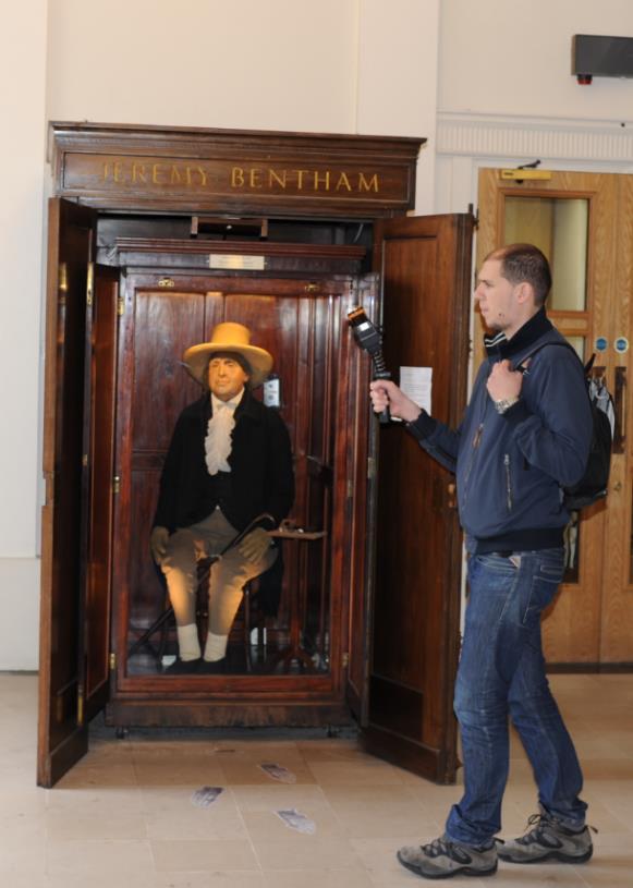
7 Chadwick GREEN BIM A detailed Case study of UCL Chadwick building Data Capture 3D Laserscanning Thermal Imaging Parametric As Built Model Environmental parameters Space utilisation Environmental Modelling and Analysis Well-being and health Energy Emissions Water Space Costs Improvements Recommendations Scenarios Emissions Reduction Improving performance and sustainability UCL CEGE Sustainability Strategy - Smart Retrofit - Innovative Research - Achievement Carbon Reduction targets


8 Chadwick GREEN BIM building the initiative Research into BIM started in the scope of cooperation with FARO Vibrant Green Group keeps winning awards Decision to develop the Topic systematically in four focus Groups CEGE, the Faculty of Engineering and Estates and Facilities jointly agreed funding for a first Phase to build Chadwick GreenBIM
9 Chadwick GREEN BIM Phase 1 Comprehensive data collection including As build documentation: External data: Space borne, airborne, mobile mapping Internal Complete 3D Laserscan of the building Collecting environmental data Establishing a space utilisation monitoring scheme Collecting further information from any source possible (Estates and Facility records)


10 3D Laserscanning concept: Registered using a traditional survey network Surveyed reference system to guarantee geometric fidelity

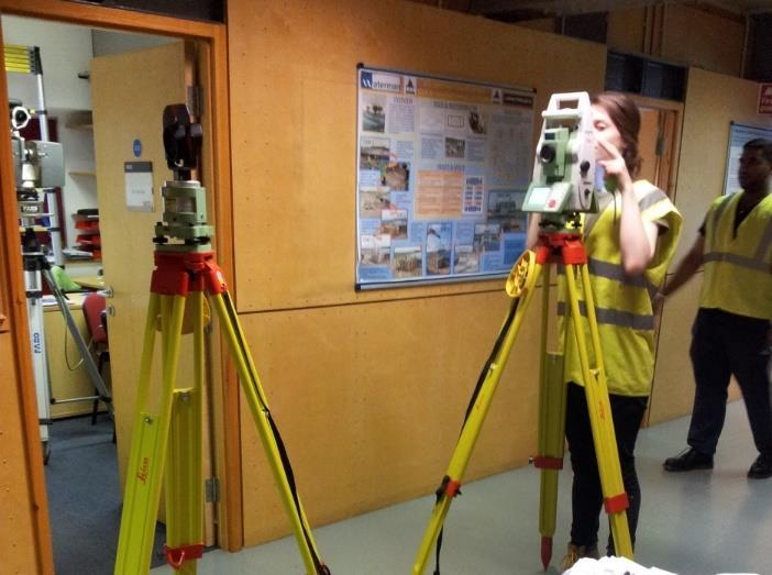
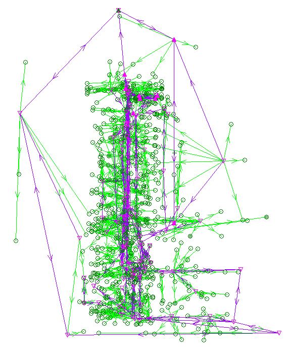
11 Rigorous Survey Network:

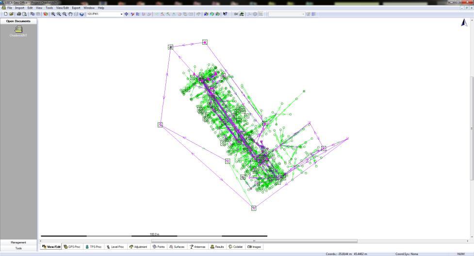
12 Rigorous Survey Network:


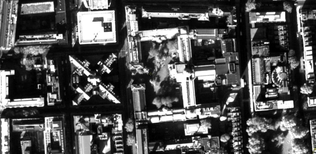
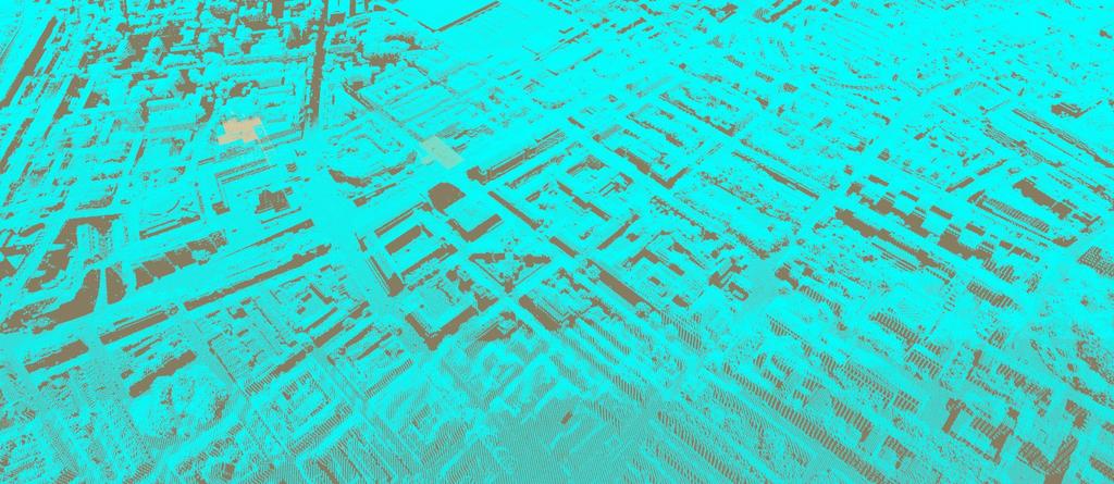
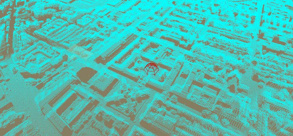
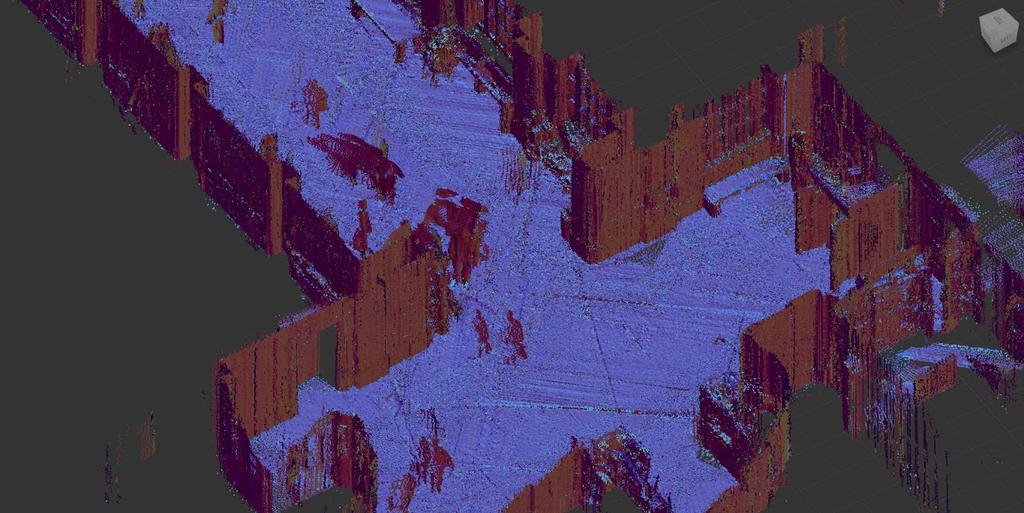
13 The Scans: Many Scans placed together: Birdseye view on Pointcloud: outside:

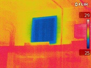
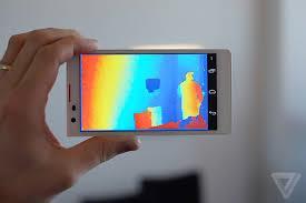
14 Thermal Images:


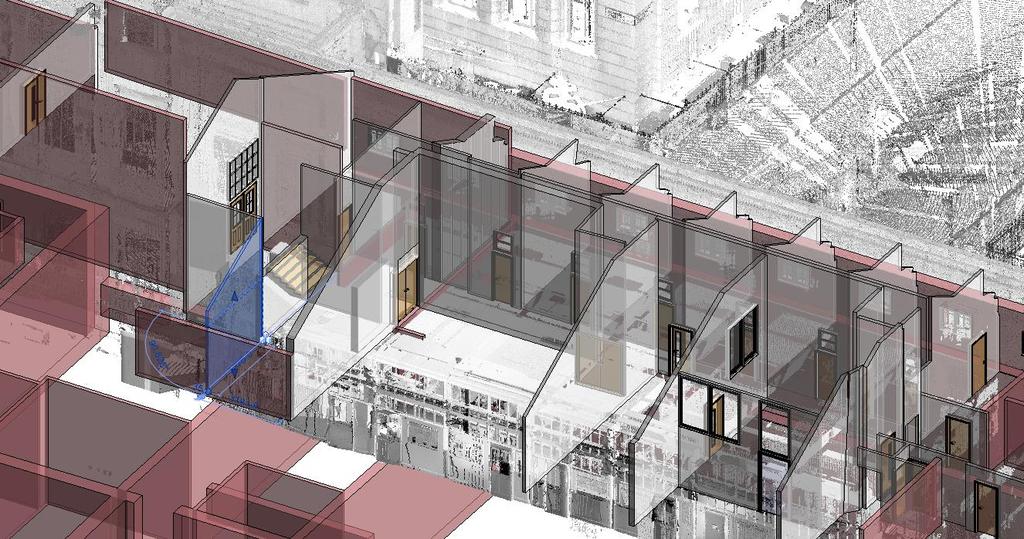
15 Point Clouds based modelling in Revit:


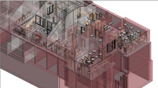
16 Point Clouds based modelling in Revit:


17 CEGE - 3DIMPact Some results:

18 Some results:


19 CEGE - 3DIMPact Chadwick GREEN BIM Multiple Scales

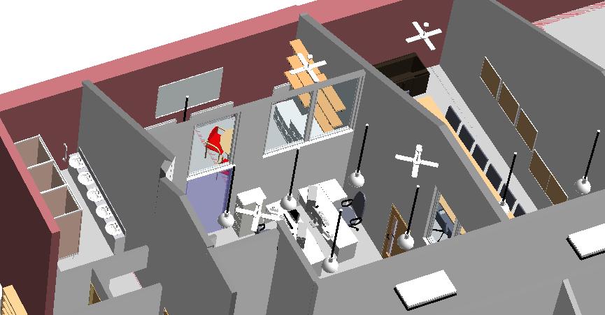
20 Application Environmental Comfort Analysis Sensor Network: Temperature, Light Intensity and Relative Humidity Currently 20 Sensors were placed in chosen rooms around the building, with the aim to represent the variation in working conditions across a variety of room function and occupation. The data collected will also be used to validate future CFD and thermal models.

21 Application Environmental Comfort Analysis Thermal Imaging and Airflow measurement A thermal image camera was used in the 20 rooms which contain sensors. Through the thermal imaging process hot and cold spots could be seen. This will help give an idea about the thermal gradients which exist within the building. Air vents within the 20 rooms were assessed to see the direction of flow (if any) and the thermal image camera was used to visualise the temperature of the air Using an Anemometer, the volumetric flow rate, velocity and temperature of air entering/exiting the vent was measured. In general, it was found the many of the vents were disfunctional, only 2 rooms could be considered to have adequate ventilation.


22 Application Environmental Comfort Analysis Comfort Analysis: Simulation vs. real Measurements The next phase of the project will involve the use of the created Parametric model as the dataset in CFD simulations and thermal modelling. To progress to the next phase the validity and reliability of software and modelling techniques were assessed.

23 Application Environmental Comfort Analysis Comfort Analysis: Simulation vs. real Measurements


24 Lessons learned: Labour intensive Static Scanning takes to long Post processing Rigorous data Management is required For new collected data and legacy data Documentation and Quality assessment Bim maturity Level3 remains the Holy Grail Interdisciplinary Interfaces and requirements Need to be defined A specialised Skillset is required!

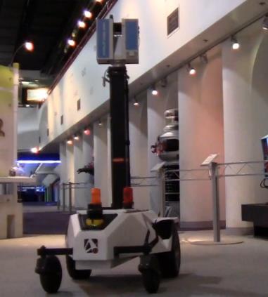
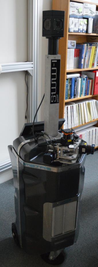
25 Lessons learned:
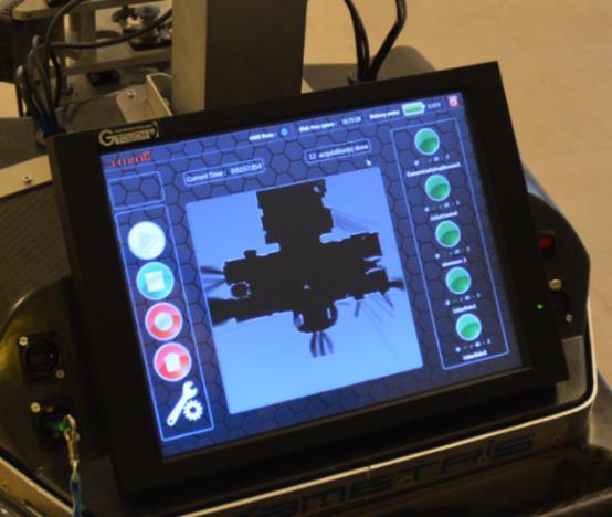
26 Emerging Indoor Mobile Mapping (IMMS) Master Thesis by Georgios Apostolopoulos
27 Emerging Indoor Mobile Mapping (IMMS) Driven by: Technical advances and innovation by a vibrant robotics and computer vision community the need of more efficient/rapid 3D data capture solutions for fast Scanning campaigns (Ref. Rechenbach) Kinematic systems; automated Automated Pre-Processing incl. registration georeference Requirements of range of identified applications Trade of between speed and accuracy Environmental simulations, asset, space and change management etc.
28 Emerging Indoor Mobile Mapping (IMMS) Aims of the study: 1) To assess the performance of indoor mobile systems against a traditional survey workflow. 2) To investigate the quality of the generated point clouds and the ability to design accurate geometry for BIM applications. 3) To provide a starting point for discussion. 4) Further development and exploitation of the systems.


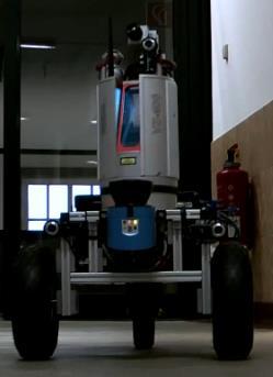
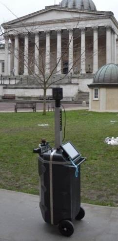
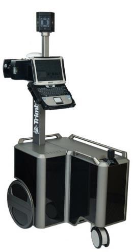
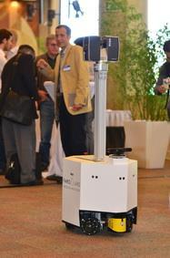


29 Overview of current Systems Trolley-Based Robotic Hand-held Experimental (?!)


30 Study areal Long corridor ( m). Repetitive, but clean structures. Frequent pedestrian traffic. South Cloisters of UCL

31 Static Solutions: Focus3Ds & Leica TS15 Focus3D: A state-of-the-art scanner commonly used for building surveys. Its light weight and compactness make it ideal for indoor applications. Data are treated as the reference due to higher accuracy and density. Leica TS15: To establish a control network where the results can be compared. A method still used for building surveys. Georeference of Focu3D data.


32 Trolley based IMMS: Viametis i-mms


33 Trolley based IMMS: Viametis i-mms System based on 3D Lidar vision SLAM: - Small and compact - Inexpensive fast solution - Slam algorithms are complex and still subject to R&D (fast progress)

34 Viametris imms - Trajectory overlay


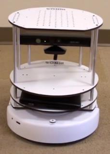
35 IMMS: CSIRO Zebedee/GeoSlam Zeb1
36 TIME IN MINUTES CEGE - 3DIMPact Data Acquisition & Analysis Points Acquired Focus 3D imms ZEB1 Viva TS15 90 million in 5 hrs 18 million in 10 min 8 million in 10 min 120 points in 3 hrs Data Analysis 5 hrs 2 hrs 10 min 3 hrs Point Density 1-2 mm 6-12 mm 8-25 mm Focus3D imms ZEB1 Viva TS15 Data Acquisition Data Analysis
37 Analysis: Point Cloud Comparison Focus 3Ds point clouds were the reference data due to higher density and accuracy, while imms and ZEB1 were the compared. imms and ZEB1 data were aligned to Focus 3D with the ICP algorithm. Distance differences were calculated between corresponding points. Focus 3D - imms ICP algorithm Focus 3D - ZEB1 Deviation using the Height Function Focus 3D -imms Focus 3D - ZEB1 Deviation using the Least Square Planes Focus 3D -imms Focus 3D -ZEB1 RMS (m) Mean (m) St. Dev. (m)

38 Georeferencing The point clouds from the various systems transformed to the same coordinate system through the ICP method prior to modelling. Artefacts in the scans caused by people and glass, as well as non overlapping areas were removed prior to alignment Registration of the Focus3D and i-mms point clouds Registration of the Focus3D and ZEB1 point clouds

39 Modelling Models were designed in Revit Architecture Point clouds have to be converted in the proprietary RCS format, before import to Revit. Specific elements were selected and the comparison was based on the calculated dimensions. The quality of the underlying point clouds affects the modelling procedure. A LoD 3 has been chosen, corresponding to a point spacing of 10 mm.

40 Modelling Primary focus was given to model the basic detail of elements. Materials and structural elements were excluded. Verticality & perpendicularity of walls was not taken into account. The modelling based solely on underlying point clouds.
 Mean (height) Focus 3D imms 0.035 m 0.")
41 Modelling Differences based on 10 door elements Mean (width) Mean (height) Focus 3D imms m m Focus 3D ZEB m m Leica TS15 & tape measures - imms Leica TS15 & tape measures - ZEB m m m m Differences based on 7 window elements Mean (width) Mean (height) Focus 3D imms m m Focus 3D ZEB m m Leica TS15 & tape measures - imms Leica TS15 & tape measures - ZEB m m m m

42 Modelling Differences based on lengths Mean (length) Max (length) Focus 3D imms m m Focus 3D ZEB1 Leica TS15 & tape measures - imms m m m m Leica TS15 & tape measures - ZEB m m
43 Results imms Focus 3D imms is restricted to 2D plane and a small change in the height can degrade the results.

44 Results imms Focus 3D generates a clean point cloud. Drifts on the point clouds of imms are observed. ZEB1 produces a much more sparse point cloud and does not record intensity. Georeference of ZEB1 data will remain a challenging issue. Focus 3D Better scanning performance of imms over larger distances. Long trajectories might produce bigger drifts on the data. imms and ZEB1 produce point clouds and BIM models that deviate only a few cm from a traditional survey. imms is restricted to 2D plane and a small change in the height can degrade the results.

45 Possible Applications Rapid data capture for asset management. Room planning. Maintenance operations. Operational information and supervision during building construction. Monitoring applications and deformation analysis. Architectural reconstruction. Not for featureless open areas and tunnel like environments.

46 Future Work UCL has bought a new imms from Viametris. Close collaboration between Viametris and UCL researchers to mitigate the limitations of the system. Integration of an IMU unit to the system, so as to make it fully 3D. Integration of a Faro laser scanner as an extra profiler. Total station tracking. Calibration of the system in a laboratory environment.


47 So what is next?
48 BIM education Skills required! MSc Geomatic BIM: We created a new dedicated MSc Programme called Geomatics for BIM (first intake 2014) New applied BIM module First cohort capped to 25 students (oversubscribed by 2/1) Competitive
49 Student projects: Self directed project: students work in groups competitive to each other and deliver a result to a client. 4 Groups: 2 groups used the Focus 3Ds. 2 groups the Viametris imms. Students shall apply standard technologies introduced and investigate aspects of the project further


")
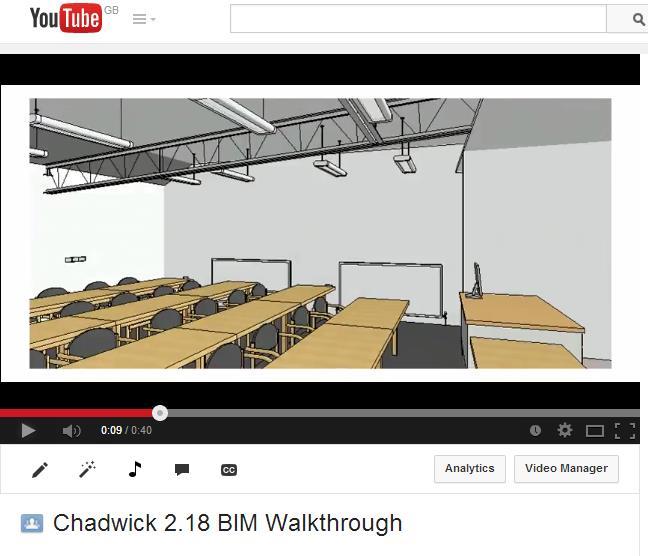
50 Some results: Mobile viewing (BIM 360 Glue)
51 Some Conclusions BIM will be a vibrant area for the foreseeable future. Technology will continue to accelerate: - Change the way we work. - Encourage cooperation and multidisciplinary cooperation. New Perspectives for young people
Delivering the value of BIM to Smart Mobile Devices
 UCL CEGE Geomatic Delivering the value of BIM to Smart Mobile Devices Capturing 3D Geometry for BIM (Scan2BIM) Dietmar Backes, Charles Thomson, Stuart McLeod, Prof Stuart Robson, Dr Jan Boehm, Dr David
Example of Monitoring Requirement
 CEGE Department 3DIMPact of Civil, Environmental & Geomatic Engineering (CEGE) 3D Imaging, Metrology, Photogrammetry Applied Coordinate Technologies (3DIMPact) Optical non-contact railway track measurement
Rapid Building information modeling. Ivar Oveland 2013
 Rapid Building information modeling Ivar Oveland 2013 Case study How can I rapidly create a building information model? Today: Different methods are used today to establish a building information model
ASSETS DATA INVENTORY BASED ON BUILDING INFORMATION MODELLING
 ASSETS DATA INVENTORY BASED ON BUILDING INFORMATION MODELLING Asep Yusup Saptari (Surveying and Cadastre Research Group) Geodesy And Geomatic Earth Science And Engineering Faculty Institut Teknologi Bandung
3D Point Cloud Processing
 3D Point Cloud Processing The image depicts how our robot Irma3D sees itself in a mirror. The laser looking into itself creates distortions as well as changes in intensity that give the robot a single
Three-Dimensional Laser Scanner. Field Evaluation Specifications
 Stanford University June 27, 2004 Stanford Linear Accelerator Center P.O. Box 20450 Stanford, California 94309, USA Three-Dimensional Laser Scanner Field Evaluation Specifications Metrology Department
UAVs & IMAGES ACCESSORIES ABOUT GEXCEL
 LIDAR SOFTWARE UAVs & IMAGES MONITORING MOBILE MAPPING ACCESSORIES OTHER ABOUT GEXCEL BUSINESS TEAM LOCATIONS Gexcel offices are located in Italy in two Innovation Centers SALES NETWORK Gexcel s worldwide
Quality Assurance and Quality Control Procedures for Survey-Grade Mobile Mapping Systems
 Quality Assurance and Quality Control Procedures for Survey-Grade Mobile Mapping Systems Latin America Geospatial Forum November, 2015 Agenda 1. Who is Teledyne Optech 2. The Lynx Mobile Mapper 3. Mobile
Large-Scale. Point Cloud Processing Tutorial. Application: Mobile Mapping
 Large-Scale 3D Point Cloud Processing Tutorial 2013 Application: Mobile Mapping The image depicts how our robot Irma3D sees itself in a mirror. The laser looking into itself creates distortions as well
REPORT 1A Analysis of needs and possibilities with the technology of the future
 REPORT 1A Analysis of needs and possibilities with the technology of the future Part of R&D project Infrastructure in 3D in cooperation between Innovation Norge, Trafikverket and TerraTec Trafikverket
INDOOR MODELLING BENCHMARK FOR 3D GEOMETRY EXTRACTION
 INDOOR MODELLING BENCHMARK FOR 3D GEOMETRY EXTRACTION Charles Thomson* & Jan Boehm Dept. of Civil, Environmental & Geomatic Engineering (CEGE), University College London, Gower Street, London, WC1E 6BT,
ROAD-SCANNER COMPACT APPLICATION FIELDS MAIN FEATURES
 ROAD-SCANNER COMPACT Mobile Mapping System by GEXCEL & SITECO collaboration A smaller mobile system for asset management and cartography suited for ZOLLER & FRÖHLICH PROFILER 9012 laser scanner. 2 + 3
Suite en It Up with Autodesk ReCap
 Chad Studer ADSK Solutions RC3165 Static and mobile laser scanning technologies capture millions of points and provide photorealistic interactive virtual sites known as point clouds. With Autodesk ReCap
Rigorous Scan Data Adjustment for kinematic LIDAR systems
 Rigorous Scan Data Adjustment for kinematic LIDAR systems Paul Swatschina Riegl Laser Measurement Systems ELMF Amsterdam, The Netherlands 13 November 2013 www.riegl.com Contents why kinematic scan data
HANDHELD MOBILE MAPPING / 3D LASER MAPPING SOLUTIONS. ZEB Family Brochure. geoslam.com
 HANDHELD MOBILE MAPPING / 3D LASER MAPPING SOLUTIONS ZEB Family Brochure geoslam.com NEW Long range, greater intensity, UAV ready HANDHELD BACKPACK UAV Effortless Data Capture Your tool to capture, view
From Point Cloud to Building Information Model
 UCL CIVIL, ENVIRONMENTAL AND GEOMATIC ENGINEERING From Point Cloud to Building Information Model Capturing and Processing Survey Data Towards Automation for High Quality 3D Models to Aid a BIM Process
GNSS/INS for High Accuracy Mobile Mapping. Olaf Gross 11 th Terrasolid European User Event Kittilä, Finland
 GNSS/INS for High Accuracy Mobile Mapping Olaf Gross 11 th Terrasolid European User Event 15.02.2012 Kittilä, Finland IGI mbh Founded 1978 25 staff about half in R&D More than 380 customers in 60 different
Robust Automatic 3D Point Cloud Registration and Object Detection
 FEATURE EXTRACTION FOR BIM Robust Automatic 3D Point Cloud Registration and Object Detection BY DAVID SELVIAH This article presents a ground-breaking approach to generating survey data for a BIM process
Energy Action Plan 2015
 Energy Action Plan 2015 Purpose: In support of the Texas A&M University Vision 2020: Creating a Culture of Excellence and Action 2015: Education First Strategic Plan, the Energy Action Plan (EAP) 2015
Construction Progress Management and Interior Work Analysis Using Kinect 3D Image Sensors
 33 rd International Symposium on Automation and Robotics in Construction (ISARC 2016) Construction Progress Management and Interior Work Analysis Using Kinect 3D Image Sensors Kosei Ishida 1 1 School of
INDOOR 3D MODEL RECONSTRUCTION TO SUPPORT DISASTER MANAGEMENT IN LARGE BUILDINGS Project Abbreviated Title: SIMs3D (Smart Indoor Models in 3D)
") INDOOR 3D MODEL RECONSTRUCTION TO SUPPORT DISASTER MANAGEMENT IN LARGE BUILDINGS Project Abbreviated Title: SIMs3D (Smart Indoor Models in 3D) PhD Research Proposal 2015-2016 Promoter: Prof. Dr. Ir. George
INDOOR 3D MODEL RECONSTRUCTION TO SUPPORT DISASTER MANAGEMENT IN LARGE BUILDINGS Project Abbreviated Title: SIMs3D (Smart Indoor Models in 3D) PhD Research Proposal 2015-2016 Promoter: Prof. Dr. Ir. George
Introducing. GeoSLAM. The experts in go anywhere 3D mobile mapping technology. The Company. The Technology. The Applications. Strategic Partnerships
 Introducing GeoSLAM The experts in go anywhere 3D mobile mapping technology The Company The Technology The Applications Strategic Partnerships The Company Multipurpose Presentation Template 2 About Us
Intensity Augmented ICP for Registration of Laser Scanner Point Clouds
 Intensity Augmented ICP for Registration of Laser Scanner Point Clouds Bharat Lohani* and Sandeep Sashidharan *Department of Civil Engineering, IIT Kanpur Email: blohani@iitk.ac.in. Abstract While using
THE ISPRS/EUROSDR BENCHMARK ON MULTI-PLATFORM PHOTOGRAMMETRY: RESULTS AND LESSON LEARNT FRANCESCO NEX AND MARKUS GERKE
 THE ISPRS/EUROSDR BENCHMARK ON MULTI-PLATFORM PHOTOGRAMMETRY: RESULTS AND LESSON LEARNT FRANCESCO NEX AND MARKUS GERKE Overview Summary of the results Statistics Data release What s next? ISPRS / EuroSDR
Automating Data Alignment from Multiple Collects Author: David Janssen Optech Incorporated,Senior Technical Engineer
 Automating Data Alignment from Multiple Collects Author: David Janssen Optech Incorporated,Senior Technical Engineer Stand in Presenter: David Collison Optech Incorporated, Regional Sales Manager Introduction
Runway Centerline Deviation Estimation from Point Clouds using LiDAR imagery
 Runway Centerline Deviation Estimation from Point Clouds using LiDAR imagery Seth Young 1, Charles Toth 2, Zoltan Koppanyi 2 1 Department of Civil, Environmental and Geodetic Engineering The Ohio State
3D MODELING OF CLOSE-RANGE OBJECTS: PHOTOGRAMMETRY OR LASER SCANNING?
 3D MODELING OF CLOSE-RANGE OBJECTS: PHOTOGRAMMETRY OR LASER SCANNING? F. Remondino 1 A. Guarnieri 2 A. Vettore 2 1 Institute of Geodesy and Photogrammetry ETH Hönggerberg - Zurich, Switzerland e-mail:
3D Terrestrial Laser Scanner Innovative Applications for 3D Documentation
 3D Terrestrial Laser Scanner Innovative Applications for 3D Documentation Rodney Chaffee Head of Sales, FARO Asia Pacific 3D Laser Scaning Market 2017 2.3 Billion $ 2012 1.3 Billion $ CAGR : > 12% Source:
2/19/2018. Who are we? Who am I? What is Scanning? How does scanning work? How does scanning work? Scanning for Today s Surveyors
 2/19/2018 Who are we? Scanning for Today s Surveyors Survey, GIS, and Construction dealer Founded in 1988 Employee Owned Headquartered in Bismarck, ND States covered: ND, SD, MN, MT, WY, CO, UT, ID, WA,
EUROPEAN COMMISSION DIRECTORATE GENERAL FOR INTERPRETATION
 EUROPEAN COMMISSION DIRECTORATE GENERAL FOR INTERPRETATION RESOURCES AND SUPPORT DIRECTORATE Management of Technical Infrastructure Brussels, 23 January 2013 M/516 EN Ref. Ares(2013)136537-04/02/2013 REQUEST
Sensor Integration and Image Georeferencing for Airborne 3D Mapping Applications
 Sensor Integration and Image Georeferencing for Airborne 3D Mapping Applications By Sameh Nassar and Naser El-Sheimy University of Calgary, Canada Contents Background INS/GPS Integration & Direct Georeferencing
IP-S2 HD. High Definition 3D Mobile Mapping System
 IP-S2 HD High Definition 3D Mobile Mapping System Integrated, turnkey solution Georeferenced, Time-Stamped, Point Clouds and Imagery High Density, Long Range LiDAR sensor for ultimate in visual detail
GeoSLAM Overview. The experts in go-anywhere 3D mobile mapping technology
 GeoSLAM Overview The experts in go-anywhere 3D mobile mapping technology 1 About GeoSLAM The experts in go-anywhere 3D mobile mapping technology 2 Who We Are GeoSLAM is a global market leader in go-anywhere
Survey and Audit Service Schedule. Airflow and Thermal Imaging Survey Service Schedule. Data Centre Solutions Expertly Engineered
 Survey and Audit Service Schedule Airflow and Thermal Imaging Survey Service Schedule Data Centre Solutions Expertly Engineered Consult optimisation, audit and survey services Data Centre Services Workspace
OUTDOOR AND INDOOR NAVIGATION WITH MICROSOFT KINECT
 DICA-Dept. of Civil and Environmental Engineering Geodesy and Geomatics Section OUTDOOR AND INDOOR NAVIGATION WITH MICROSOFT KINECT Diana Pagliari Livio Pinto OUTLINE 2 The Microsoft Kinect sensor The
SPAR, ELMF 2013, Amsterdam. Laser Scanning on the UK Highways Agency Network. Hamish Grierson Blom Uk
 SPAR, ELMF 2013, Amsterdam Laser Scanning on the UK Highways Agency Network Hamish Grierson Blom Uk www.blomasa.com www.blom-uk.co.uk Blom UK Part of the Blom Group Blom Group - Europe s largest aerial
Smart Data Centres. Robert M Pe, Data Centre Consultant HP Services SEA
 Smart Data Centres Robert M Pe, Data Centre Consultant Services SEA 2006 Hewlett-Packard Development Company, L.P. The information contained herein is subject to change without notice Content Data center
Precise laser-based optical 3D measurement of welding seams under water
 Precise laser-based optical 3D measurement of welding seams under water ISPRS/CIPA Workshop Underwater 3D Recording & Modeling" Piano di Sorrento (Napoli), Italy 16. 17. April 2015 Tanja Ekkel (M.Sc.)
A NEW AUTOMATIC SYSTEM CALIBRATION OF MULTI-CAMERAS AND LIDAR SENSORS
 A NEW AUTOMATIC SYSTEM CALIBRATION OF MULTI-CAMERAS AND LIDAR SENSORS M. Hassanein a, *, A. Moussa a,b, N. El-Sheimy a a Department of Geomatics Engineering, University of Calgary, Calgary, Alberta, Canada
Exploiting Indoor Mobile Laser Scanner Trajectories for Interpretation of Indoor Scenes
 Exploiting Indoor Mobile Laser Scanner Trajectories for Interpretation of Indoor Scenes March 2018 Promoter: Prof. Dr. Ir. George Vosselman Supervisor: Michael Peter 1 Indoor 3D Model Reconstruction to
High Resolution Tree Models: Modeling of a Forest Stand Based on Terrestrial Laser Scanning and Triangulating Scanner Data
 ELMF 2013, 11-13 November 2013 Amsterdam, The Netherlands High Resolution Tree Models: Modeling of a Forest Stand Based on Terrestrial Laser Scanning and Triangulating Scanner Data Lothar Eysn Lothar.Eysn@geo.tuwien.ac.at
AN EVALUATION PIPELINE FOR INDOOR LASER SCANNING POINT CLOUDS
 AN EVALUATION PIPELINE FOR INDOOR LASER SCANNING POINT CLOUDS S. Karam 1, *, M. Peter 1, S. Hosseinyalamdary 1, G. Vosselman 1 1 Dept. of Earth Observation Science, Faculty ITC, University of Twente, 7514
Exterior Orientation Parameters
 Exterior Orientation Parameters PERS 12/2001 pp 1321-1332 Karsten Jacobsen, Institute for Photogrammetry and GeoInformation, University of Hannover, Germany The georeference of any photogrammetric product
GeoSLAM Overview. The global leader in go anywhere 3D mobile mapping technology. 1
 GeoSLAM Overview The global leader in go anywhere 3D mobile mapping technology. 1 About GeoSLAM The global leader in go anywhere 3D mobile mapping technology. 2 Who We Are GeoSLAM is a global market leader
STATE-OF-THE-ART in DENSE IMAGE MATCHING
 STATE-OF-THE-ART in DENSE IMAGE MATCHING Fabio REMONDINO 3D Optical Metrology (3DOM) Bruno Kessler Foundation (FBK) Trento, Italy Email: remondino@fbk.eu http://3dom.fbk.eu Bruno Kessler Foundation (FBK)
POINT CLOUD REGISTRATION: CURRENT STATE OF THE SCIENCE. Matthew P. Tait
 POINT CLOUD REGISTRATION: CURRENT STATE OF THE SCIENCE Matthew P. Tait Content 1. Quality control: Analyzing the true errors in Terrestrial Laser Scanning (TLS) 2. The prospects for automatic cloud registration
Comparing Aerial Photogrammetry and 3D Laser Scanning Methods for Creating 3D Models of Complex Objects
 Comparing Aerial Photogrammetry and 3D Laser Scanning Methods for Creating 3D Models of Complex Objects A Bentley Systems White Paper Cyril Novel Senior Software Engineer, Bentley Systems Renaud Keriven
Critical Aspects when using Total Stations and Laser Scanners for Geotechnical Monitoring
 Critical Aspects when using Total Stations and Laser Scanners for Geotechnical Monitoring Lienhart, W. Institute of Engineering Geodesy and Measurement Systems, Graz University of Technology, Austria Abstract
BIM PROCESS COMPARING NEW BUILD WITH EXISTING ASSETS A VERY QUICK SUMMARY OF THE PROCESS
 : STEPPING INTO THE FUTURE WITH THE PAST HYBRID MODELLING IN THE BIM PROCESS CARL BROOKES 8 DECEMBER 2017 INTRODUCTION Very quick summary of BIM process Comparing New build with existing assets 3D model
CE 59700: LASER SCANNING
 Digital Photogrammetry Research Group Lyles School of Civil Engineering Purdue University, USA Webpage: http://purdue.edu/ce/ Email: ahabib@purdue.edu CE 59700: LASER SCANNING 1 Contact Information Instructor:
inspiring innovative Infratech Jyväskylä infra3d unique simplify 12 May 2017 Manuel Dätwyler Product Management infra3d
 inspiring Infratech Jyväskylä infra3d 12 May 2017 Manuel Dätwyler Product Management infra3d simplify unique innovative What s the issue? «cost-intensive infrastructure management» 2 What are yours subjects
ifp Universität Stuttgart Performance of IGI AEROcontrol-IId GPS/Inertial System Final Report
 Universität Stuttgart Performance of IGI AEROcontrol-IId GPS/Inertial System Final Report Institute for Photogrammetry (ifp) University of Stuttgart ifp Geschwister-Scholl-Str. 24 D M. Cramer: Final report
ASHRAE. Shaping Tomorrows Built Environment Today. Erich Binder - Director At Large
 ASHRAE Shaping Tomorrows Built Environment Today Erich Binder - Director At Large http://ashare.org/ ASHRAE is the Answer People spend about 90 % of their lives indoors. Buildings are the places where
NATIONWIDE POINT CLOUDS AND 3D GEO- INFORMATION: CREATION AND MAINTENANCE GEORGE VOSSELMAN
 NATIONWIDE POINT CLOUDS AND 3D GEO- INFORMATION: CREATION AND MAINTENANCE GEORGE VOSSELMAN OVERVIEW National point clouds Airborne laser scanning in the Netherlands Quality control Developments in lidar
Snow cover change detection with laser scanning range and brightness measurements
 Snow cover change detection with laser scanning range and brightness measurements Sanna Kaasalainen, Harri Kaartinen, Antero Kukko, Henri Niittymäki Department of Remote Sensing and Photogrammetry 5th
Location Based Technology Expert. Mobile VR 3D modeling for BIM
 Location Based Technology Expert Mobile VR 3D modeling for BIM 50bln square meters indoor environment are waiting to be digitized and go online. So we need a way efficient enough to map the indoors VR
ACCURACY OF EXTERIOR ORIENTATION FOR A RANGE CAMERA
 ACCURACY OF EXTERIOR ORIENTATION FOR A RANGE CAMERA Jan Boehm, Timothy Pattinson Institute for Photogrammetry, University of Stuttgart, Germany jan.boehm@ifp.uni-stuttgart.de Commission V, WG V/2, V/4,
Principles for a National Space Industry Policy
 Principles for a National Space Industry Policy Commonwealth of Australia 2011 DIISR 11/144 This work is copyright. Apart from any use as permitted under the Copyright Act 1968, no part may be reproduced
A multilevel simulation framework for highly automated harvest processes enabled by environmental sensor systems
 A multilevel simulation framework for highly automated harvest processes enabled by environmental sensor systems Jannik Redenius, M.Sc., Matthias Dingwerth, M.Sc., Prof. Dr. Arno Ruckelshausen, Faculty
CyberGage360 3D SCANNERS. One-Button Automation for 3D Scan Inspection.
 CyberGage360 One-Button Automation for 3D Scan Inspection. 3D SCANNERS Unprecedented speed, accuracy and one-button simplicity for non-contact automated 3D scanning inspection. Powered by MRS Technology
An Overview of Applanix.
 An Overview of Applanix The Company The Industry Leader in Developing Aided Inertial Technology Founded on Canadian Aerospace and Defense Industry Expertise Providing Precise Position and Orientation Systems
Mobile Mapping with the Road-Scanner in France Hi-grade 1:200 scale mapping
 FARO USER CONFERENCE APRIL 27-28 2014 Mobile Mapping with the Road-Scanner in France Hi-grade 1:200 scale mapping 03/04/2014 ing. Augusto Burchi burchi@sitecoinf.it Siteco's profile Founded in 2000 as
Italian pavilion in 3D, project for EXPO 2015, Milan (Italy) JRC 3D RECONSTRUCTOR POWERFUL. ADVANCED. PROFESSIONAL
 JRC 3D RECONSTRUCTOR POWERFUL. ADVANCED. PROFESSIONAL") Italian pavilion in 3D, project for EXPO 2015, Milan (Italy) JRC 3D RECONSTRUCTOR POWERFUL. ADVANCED. PROFESSIONAL OVERVIEW JRC 3D Reconstructor is the well known multi-platform and multi-resolution software
Italian pavilion in 3D, project for EXPO 2015, Milan (Italy) JRC 3D RECONSTRUCTOR POWERFUL. ADVANCED. PROFESSIONAL OVERVIEW JRC 3D Reconstructor is the well known multi-platform and multi-resolution software
IGTF 2016 Fort Worth, TX, April 11-15, 2016 Submission 149
 IGTF 26 Fort Worth, TX, April -5, 26 2 3 4 5 6 7 8 9 2 3 4 5 6 7 8 9 2 2 Light weighted and Portable LiDAR, VLP-6 Registration Yushin Ahn (yahn@mtu.edu), Kyung In Huh (khuh@cpp.edu), Sudhagar Nagarajan
KRISTAPS KLAVA - HEAD OF LASER SCANNING DEPARTMENT AT MERKO 3D LASER SCANNING POSSIBILITIES IN REAL ESTATE
 KRISTAPS KLAVA - HEAD OF LASER SCANNING DEPARTMENT AT MERKO 3D LASER SCANNING POSSIBILITIES IN REAL ESTATE Overview 1. What is laser scanning; 2. Technology; 3. End results of laser scanning; 4. Applications;
Using SLAM-based Handheld Laser Scanning to Gain Information on Difficult-to-access Areas for Use in Maintenance Model
 Using SLAM-based Handheld Laser Scanning to Gain Information on Difficult-to-access Areas for Use in Maintenance Model T. Makkonen a, R. Heikkilä a, P. Tölli b, F. Fedorik a a Construction Technology Research
The YellowScan Surveyor: 5cm Accuracy Demonstrated
 The YellowScan Surveyor: 5cm Accuracy Demonstrated Pierre Chaponnière1 and Tristan Allouis2 1 Application Engineer, YellowScan 2 CTO, YellowScan Introduction YellowScan Surveyor, the very latest lightweight
The Most Comprehensive Solution for Indoor Mapping Applications
 The Most Comprehensive Solution for Indoor Mapping Applications TRIMBLE INDOOR MOBILE MAPPING SOLUTION TRIMBLE INDOOR MOBILE MAPPING SOLUTION (TIMMS): HIGH EFFICIENCY, MAXIMUM FLEXIBILITY, ALL-IN-ONE PACKAGE
A New Protocol of CSI For The Royal Canadian Mounted Police
 A New Protocol of CSI For The Royal Canadian Mounted Police I. Introduction The Royal Canadian Mounted Police started using Unmanned Aerial Vehicles to help them with their work on collision and crime
Summary of Research and Development Efforts Necessary for Assuring Geometric Quality of Lidar Data
 American Society for Photogrammetry and Remote Sensing (ASPRS) Summary of Research and Development Efforts Necessary for Assuring Geometric Quality of Lidar Data 1 Summary of Research and Development Efforts
Flexible Visual Inspection. IAS-13 Industrial Forum Horizon 2020 Dr. Eng. Stefano Tonello - CEO
 Flexible Visual Inspection IAS-13 Industrial Forum Horizon 2020 Dr. Eng. Stefano Tonello - CEO IT+Robotics Spin-off of University of Padua founded in 2005 Strong relationship with IAS-LAB (Intelligent
CHILLED WATER. HIGH PRECISION AIR CONDITIONERS, FROM 7 TO 211 kw
 IT COOLING CLOSE CONTROL AIR CONDITIONERS CHILLED WATER HIGH PRECISION AIR CONDITIONERS, FROM 7 TO 211 kw 3 Versions available Single chilled water coil Double chilled water coil High temperature IT COOLING
Scan-to-BIM. NEWBIM ApS, Galina Slavova CEO, BIM Specialist
 Scan-to-BIM NEWBIM ApS, Galina Slavova CEO, BIM Specialist Agenda What is Building Information Modeling (BIM) About NEWBIM ApS 3D Laser Scanning Integration Case Study Demonstration Building Information
Energy Efficient Design Lessons Learned & Best Practices
 Energy Efficient Design Lessons Learned & Best Practices Presented to: Energy Design Conference Preconference Workshop Duluth, Minnesota February 20, 2017 Presented by: Rebecca Ellis, PE, LEED AP BD+C,
Drones for research - Observing the world in 3D from a LiDAR-UAV
 Drones for research - Observing the world in 3D from a LiDAR-UAV Program lunch seminar: Lammert Kooistra: The Unmanned Aerial Remote Sensing Facility goes 3D: Unmanned Aerial Laser Scanning Sander Mücher:
3D Data Acquisition in Tunnels Optimizing Track Time Using Terrestrial Mobile LiDAR. Scanning. Michael R. Frecks, PLS.
 3D Data Acquisition in Tunnels Optimizing Track Time Using Terrestrial Mobile LiDAR Scanning Michael R. Frecks, PLS President/CEO AREMA 2013 1207 Understanding mobile 3D LiDAR? light detection and ranging
3D Grid Size Optimization of Automatic Space Analysis for Plant Facility Using Point Cloud Data
 33 rd International Symposium on Automation and Robotics in Construction (ISARC 2016) 3D Grid Size Optimization of Automatic Space Analysis for Plant Facility Using Point Cloud Data Gyu seong Choi a, S.W.
REPRESENTATION REQUIREMENTS OF AS-IS BUILDING INFORMATION MODELS GENERATED FROM LASER SCANNED POINT CLOUD DATA
 REPRESENTATION REQUIREMENTS OF AS-IS BUILDING INFORMATION MODELS GENERATED FROM LASER SCANNED POINT CLOUD DATA Engin Burak Anil 1 *, Burcu Akinci 1, and Daniel Huber 2 1 Department of Civil and Environmental
USE THE 3D LASER SCANNING FOR DOCUMENTATION THE RIGA CATHEDRAL IN LATVIA
 USE THE 3D LASER SCANNING FOR DOCUMENTATION THE RIGA CATHEDRAL IN LATVIA Maris Kalinka, Elina Rutkovska, Department of Geomatic, Riga Technical University, Azenes 16-109, Riga, Latvia, geomatika@geomatika.lv
Comparing Aerial Photogrammetry and 3D Laser Scanning Methods for Creating 3D Models of Complex Objects
 www.bentley.com Comparing Aerial Photogrammetry and 3D Laser Scanning Methods for Creating 3D Models of Complex Objects A Bentley White Paper Cyril Novel Senior Software Engineer, Bentley Systems Renaud
Digital Preservation of the Aurelius Church and the Hirsau Museum Complex by Means of HDS and Photogrammetric Texture Mapping
 Master Thesis Ruxandra MOROSAN Ruxandra MOROSAN Digital Preservation of the Aurelius Church and the Hirsau Museum Complex by Means of HDS and Photogrammetric Texture Mapping Duration of the Thesis: 6 months
How UAE is Driving Smart Sustainable Cities: key Achievements and Future Considerations
 How UAE is Driving Smart Sustainable Cities: key Achievements and Future Considerations By Dr. Saeed Al Dhaheri @DDSaeed Chairman, We are the leading Smart Solutions Integrator. With our far sight and
2D-based Indoor Mobile Laser Scanning for Construction Digital Mapping Application with BIM
 Presented at the FIG Congress 2018, May 6-11, 2018 in Istanbul, Turkey 2D-based Indoor Mobile Laser Scanning for Construction Digital Mapping Application with BIM Chao CHEN Llewellyn TANG Craig M HANCOCK
SOFTWARE TOOLS FROM BUILDINGS ENERGY SIMULATION
 Bulletin of the Transilvania University of Braşov CIBv 2015 Vol. 8 (57) Special Issue No. 1-2015 SOFTWARE TOOLS FROM BUILDINGS ENERGY SIMULATION M. HORNEȚ 1 L. BOIERIU 1 Abstract: Energy simulation software
Trimble Indoor Mobile Mapping Solution
 Kevin Perkins Applanix Corp. NATIONAL SURVEYING, MAPPING & GEOSPATIAL CONFERENCE - MARCH 13-17, 2017 Trimble Indoor Mobile Mapping Solution Why Indoor Mapping? The need: As-built maps/models of indoor
CyberGage 360 3D SCANNERS. One-Button Automation for 3D Scan Inspection.
 CyberGage 360 One-Button Automation for 3D Scan Inspection. Powered by MRS Technology 3D SCANNERS Unprecedented speed, accuracy and one-button simplicity for non-contact automated 3D scanning inspection.
Evaluation of Structure from Motion (SfM) in Compact, Long Hallways
 in Compact, Long Hallways") Evaluation of Structure from Motion (SfM) in Compact, Long Hallways Structure from Motion (SfM) is an emerging technology which can generate 3D point clouds from a series of overlapping 2D images. Research
Evaluation of Structure from Motion (SfM) in Compact, Long Hallways Structure from Motion (SfM) is an emerging technology which can generate 3D point clouds from a series of overlapping 2D images. Research
Development of a Test Field for the Calibration and Evaluation of Kinematic Multi Sensor Systems
 Development of a Test Field for the Calibration and Evaluation of Kinematic Multi Sensor Systems DGK-Doktorandenseminar Graz, Austria, 26 th April 2017 Erik Heinz Institute of Geodesy and Geoinformation
Addressing Deferred Maintenance with Advanced Facility Condition Assessments at the University of Arizona
 Addressing Deferred Maintenance with Advanced Facility Condition Assessments at the University of Arizona Christopher M. Kopach, AVP, The University of Arizona; APPA President Phillip Saieg, Regional Technical
HFB Benchmark, Inc. (HFBB) Democratising Student Property Ownership
 Democratising Student Property Ownership") HFB Benchmark, Inc. (HFBB) Democratising Student Property Ownership HFBB Smart Buildings & IoT JUNE 2017 Table of Contents HFBB Smart Buildings & IoT 3 HFBB and Smart Building Technology 3 What is a smart
HFB Benchmark, Inc. (HFBB) Democratising Student Property Ownership HFBB Smart Buildings & IoT JUNE 2017 Table of Contents HFBB Smart Buildings & IoT 3 HFBB and Smart Building Technology 3 What is a smart
Aided-inertial for Long-term, Self-contained GPS-denied Navigation and Mapping
 Aided-inertial for Long-term, Self-contained GPS-denied Navigation and Mapping Erik Lithopoulos, Louis Lalumiere, Ron Beyeler Applanix Corporation Greg Spurlock, LTC Bruce Williams Defense Threat Reduction
BEng (Hons) Mechanical Engineering - E440 (Under Review)
 Mechanical Engineering - E440 (Under Review)") BEng (Hons) Mechanical Engineering - E440 (Under Review) 1.0 Introduction Mechanical Engineering is the historical root of engineering practice. It gave its name to the realm of technology-based problem-solving,
BEng (Hons) Mechanical Engineering - E440 (Under Review) 1.0 Introduction Mechanical Engineering is the historical root of engineering practice. It gave its name to the realm of technology-based problem-solving,
Helping the channel capitalise on network transformation
 Helping the channel capitalise on network transformation Next generation networks The network is changing Legacy networks are being crushed by the pressures of the digital era. They weren t built for the
3GSM GmbH. Plüddemanngasse 77 A-8010 Graz, Austria Tel Fax:
 White Paper Graz, April 2014 3GSM GmbH Plüddemanngasse 77 A-8010 Graz, Austria Tel. +43-316-464744 Fax: +43-316-464744-11 office@3gsm.at www.3gsm.at Measurement and assessment of rock and terrain surfaces
Efficient and Effective Quality Assessment of As-Is Building Information Models and 3D Laser-Scanned Data
 Efficient and Effective Quality Assessment of As-Is Building Information Models and 3D Laser-Scanned Data Pingbo Tang 1, Engin Burak Anil 2, Burcu Akinci 2, Daniel Huber 3 1 Civil and Construction Engineering
ENGN D Photography / Spring 2018 / SYLLABUS
 ENGN 2502 3D Photography / Spring 2018 / SYLLABUS Description of the proposed course Over the last decade digital photography has entered the mainstream with inexpensive, miniaturized cameras routinely
2-4 April 2019 Taets Art and Event Park, Amsterdam CLICK TO KNOW MORE
 Co-Host Host 2-4 April 2019 Taets Art and Event Park, Amsterdam CLICK TO KNOW MORE Presentation Outline review modern survey methodologies available to support railway requirements measuring everything
3D Industrial plants. Documentation
 3D Industrial plants Documentation Published by: FARO Europe GmbH & Co. KG, Lingwiesenstrasse 11/2, D-70825 Korntal-Münchingen, Tel: +49 7150 9797-0, Fax: +49 7150 9797-44, info@faroeurope.com, www.faro.com
Nonlinear State Estimation for Robotics and Computer Vision Applications: An Overview
 Nonlinear State Estimation for Robotics and Computer Vision Applications: An Overview Arun Das 05/09/2017 Arun Das Waterloo Autonomous Vehicles Lab Introduction What s in a name? Arun Das Waterloo Autonomous
Storage Tank Solutions TRANSFORMING THE WAY THE WORLD WORKS
 Storage Tank Solutions Trimble TX8 Scanner: A Revolution in 3D Scanning TRUE PERFORMANCE IN A REAL WORLD The Trimble TX8 laser scanner sets new standards for performance and ease of use in high-speed collection